2023 Vol. 48, No. 3
Display Method:
2023, 48(3): 835-856.
doi: 10.3799/dqkx.2022.297
 PDF 4789KB
Abstract:
Geothermal energy is a promising clean energy. As a hot resarch topic, deep geothermal energy has been studied worldwide. The present-day crustal thermal state is the final result of the lithospheric thermal evolution and is mainly influenced by the latest tectono-thermal events. It is of great scientific significance and application value to study the influence of neoid major tectono-thermal events on crustal thermal state for further understanding and exploration of deep geothermal energy. We collect a large number of literature and summarize the research progress on the potential impacts of neoid major tectono-thermal events such as mantle plume, fault activity, lithospheric extension and volcanic activity on deep geothermal energy. Combined with the research background of China, we point out the scientific problems to be solved and emphasize the importance of the deep dynamic processes to the shallow thermal structure. It provides a theoretical basis for future exploration and development of deep geothermal resources.
Geothermal energy is a promising clean energy. As a hot resarch topic, deep geothermal energy has been studied worldwide. The present-day crustal thermal state is the final result of the lithospheric thermal evolution and is mainly influenced by the latest tectono-thermal events. It is of great scientific significance and application value to study the influence of neoid major tectono-thermal events on crustal thermal state for further understanding and exploration of deep geothermal energy. We collect a large number of literature and summarize the research progress on the potential impacts of neoid major tectono-thermal events such as mantle plume, fault activity, lithospheric extension and volcanic activity on deep geothermal energy. Combined with the research background of China, we point out the scientific problems to be solved and emphasize the importance of the deep dynamic processes to the shallow thermal structure. It provides a theoretical basis for future exploration and development of deep geothermal resources.


2023, 48(3): 857-877.
doi: 10.3799/dqkx.2022.351
Abstract:
Hot dry rock (HDR) is defined by the rock underground with high temperature but lack of fluid due to low porosity and permeability. The heat stored in HDR needs to be artificially fractured to form an enhanced geothermal system (EGS) to be exploited. The geothermal energy that can be exploited in HDR under the current technical and economic conditions is called HDR geothermal resources, which is regarded as one of the important alternative new energy sources for human beings in the future. The research on HDR began in the 1970s. After nearly 50 years of continuous development, great progress in both theory and practice has been made. Developed countries such as the United States, Japan, France, Germany, and Australia have successively invested heavily in HDR exploration, evaluation and development experiments. Moreover, some successful commercial development examples of HDR have been set up. The practices show that HDR geothermal resources are a part of deep geothermal energy, which means they often co-heat and are symbiotic with high temperature hydrothermal system. However, it is more difficult to exploit HDR than the hydrothermal system due to more complex geological conditions. Therefore, "deep geothermal energy" and "generalized EGS" concept should be advocated. According to EGS technology, we should focus on the overall development of deep hydrothermal and HDR geothermal energy. Moreover, it is developing from "rigid reservoir stimulation" to "soft reservoir stimulation" in order to overcome the environmental safety problems such as induced earthquakes. In recent years, China has carried out geological exploration on HDR in Qinghai, Tibet, Sichuan, Fujian, Guangdong, Hunan, Heilongjiang, Hainan and other areas with high heat flow. And then, preliminary drillings of HDR in Gonghe, Lijin, Huizhou, Kangding, Matouyin and northern Hainan have been implemented. Unfortunately, the breakthrough has only been made in the exploration and development experiments of HDR in Gonghe basin. Considering the distribution of global high-temperature geothermal zones, plate tectonic setting in Chinese continent, the current distribution pattern of terrestrial heat flow, lithospheric thermal structure, Moho depth and heat source in crust, Cenozoic volcanic activity, the distribution of hot springs, the distribution and active faults, and the existing HDR exploration results, the most promising HDR exploration target areas in Chinese continent are delineated, which include the Cenozoic volcanic activity area in Northeast China, Hainan Island-Leizhou Peninsula and the Yunnan-Tibet-Sichuan area (eastern Tibetan Plateau tectonic junction). In addition, medium and thick carbonate rocks with high thermal background should be the key target for deep geothermal energy exploitation.
Hot dry rock (HDR) is defined by the rock underground with high temperature but lack of fluid due to low porosity and permeability. The heat stored in HDR needs to be artificially fractured to form an enhanced geothermal system (EGS) to be exploited. The geothermal energy that can be exploited in HDR under the current technical and economic conditions is called HDR geothermal resources, which is regarded as one of the important alternative new energy sources for human beings in the future. The research on HDR began in the 1970s. After nearly 50 years of continuous development, great progress in both theory and practice has been made. Developed countries such as the United States, Japan, France, Germany, and Australia have successively invested heavily in HDR exploration, evaluation and development experiments. Moreover, some successful commercial development examples of HDR have been set up. The practices show that HDR geothermal resources are a part of deep geothermal energy, which means they often co-heat and are symbiotic with high temperature hydrothermal system. However, it is more difficult to exploit HDR than the hydrothermal system due to more complex geological conditions. Therefore, "deep geothermal energy" and "generalized EGS" concept should be advocated. According to EGS technology, we should focus on the overall development of deep hydrothermal and HDR geothermal energy. Moreover, it is developing from "rigid reservoir stimulation" to "soft reservoir stimulation" in order to overcome the environmental safety problems such as induced earthquakes. In recent years, China has carried out geological exploration on HDR in Qinghai, Tibet, Sichuan, Fujian, Guangdong, Hunan, Heilongjiang, Hainan and other areas with high heat flow. And then, preliminary drillings of HDR in Gonghe, Lijin, Huizhou, Kangding, Matouyin and northern Hainan have been implemented. Unfortunately, the breakthrough has only been made in the exploration and development experiments of HDR in Gonghe basin. Considering the distribution of global high-temperature geothermal zones, plate tectonic setting in Chinese continent, the current distribution pattern of terrestrial heat flow, lithospheric thermal structure, Moho depth and heat source in crust, Cenozoic volcanic activity, the distribution of hot springs, the distribution and active faults, and the existing HDR exploration results, the most promising HDR exploration target areas in Chinese continent are delineated, which include the Cenozoic volcanic activity area in Northeast China, Hainan Island-Leizhou Peninsula and the Yunnan-Tibet-Sichuan area (eastern Tibetan Plateau tectonic junction). In addition, medium and thick carbonate rocks with high thermal background should be the key target for deep geothermal energy exploitation.


2023, 48(3): 878-893.
doi: 10.3799/dqkx.2022.235
Abstract:
Boron is one of the typical characteristic elements in high temperature geothermal fluids. Its origin and enrichment in geothermal fluids are of great significance to understanding the formation and evolution of geothermal system and the rational development of geothermal resources. At the same time, boron is one of the harmful elements, and will cause serious negative effects on the geothermal area and its surrounding environment as geothermal fluids discharged to the surface. In recent years, under the background of large-scale exploitation and utilization of high temperature geothermal resources, the origin of boron in high temperature geothermal fluids and its environmental effects have attracted extensive attention. In this paper, the geochemistry characteristics, sources and environmental geological effects of boron in geothermal fluids are reviewed, aiming to provide insights for the rational exploitation of geothermal resources and the environmental protection near the geothermal areas.
Boron is one of the typical characteristic elements in high temperature geothermal fluids. Its origin and enrichment in geothermal fluids are of great significance to understanding the formation and evolution of geothermal system and the rational development of geothermal resources. At the same time, boron is one of the harmful elements, and will cause serious negative effects on the geothermal area and its surrounding environment as geothermal fluids discharged to the surface. In recent years, under the background of large-scale exploitation and utilization of high temperature geothermal resources, the origin of boron in high temperature geothermal fluids and its environmental effects have attracted extensive attention. In this paper, the geochemistry characteristics, sources and environmental geological effects of boron in geothermal fluids are reviewed, aiming to provide insights for the rational exploitation of geothermal resources and the environmental protection near the geothermal areas.

2023, 48(3): 894-907.
doi: 10.3799/dqkx.2022.222
Abstract:
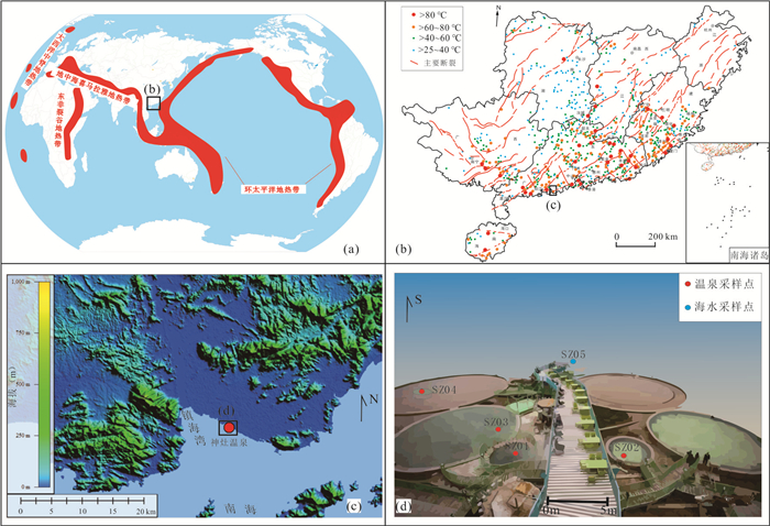
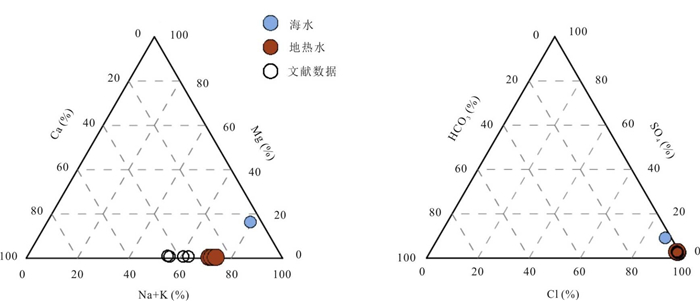
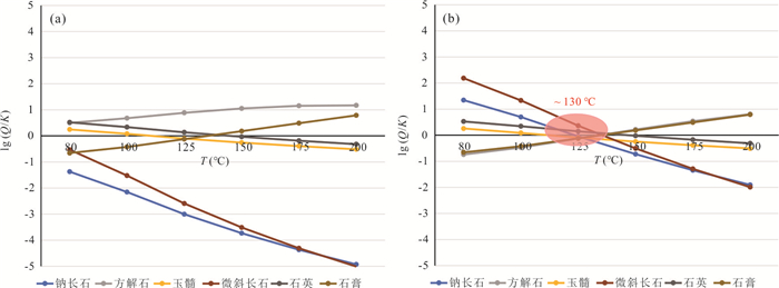
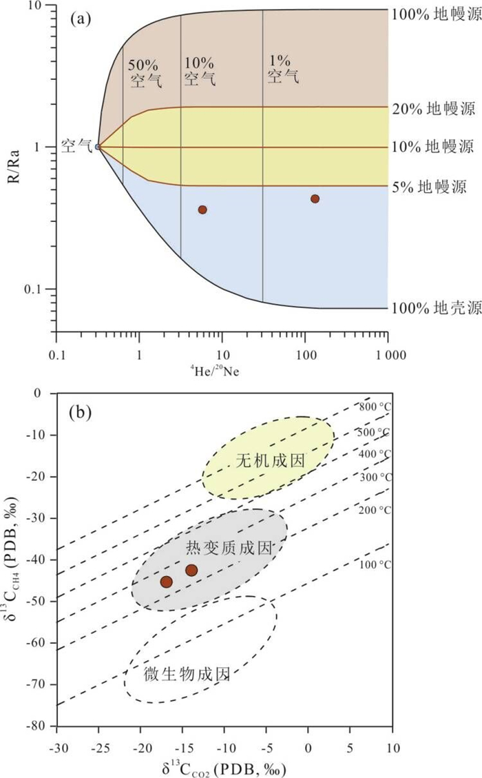
Shenzao hot springs are exposed in seawater and it is significant to reveal the circulation mechanism of geothermal fluids for the sustainable development and utilization of geothermal resources. By collecting samples of geothermal water, geothermal gas and the seawater, and testing the chemical and isotopic compositions of the samples, this study draws the following conclusions: the hot spring water is of Cl-Na-Ca type, recharged by the precipitation; the dissolved constituents are mainly derived from the dissolution of silicates and mixture with the seawater, with a mixing ratio of 29%-32%. According to the hydrochemical geothermometers, the reservoir temperature is 130 ℃, implying a circulation depth of 4 km. The atmospheric-derived N2 is the dominant component in geothermal gas and the CO2, CH4 are thermogenic products of the crustal organic sediments. In addition, the helium isotopic compositions suggest that the mantle contribution is less than 5% and the local heat flow value is about 67-69 mW/m2. Therefore, the Shenzao geothermal system is a medium-temperature convective system mainly heated by the crustal radiogenic heat source.
Shenzao hot springs are exposed in seawater and it is significant to reveal the circulation mechanism of geothermal fluids for the sustainable development and utilization of geothermal resources. By collecting samples of geothermal water, geothermal gas and the seawater, and testing the chemical and isotopic compositions of the samples, this study draws the following conclusions: the hot spring water is of Cl-Na-Ca type, recharged by the precipitation; the dissolved constituents are mainly derived from the dissolution of silicates and mixture with the seawater, with a mixing ratio of 29%-32%. According to the hydrochemical geothermometers, the reservoir temperature is 130 ℃, implying a circulation depth of 4 km. The atmospheric-derived N2 is the dominant component in geothermal gas and the CO2, CH4 are thermogenic products of the crustal organic sediments. In addition, the helium isotopic compositions suggest that the mantle contribution is less than 5% and the local heat flow value is about 67-69 mW/m2. Therefore, the Shenzao geothermal system is a medium-temperature convective system mainly heated by the crustal radiogenic heat source.


2023, 48(3): 908-922.
doi: 10.3799/dqkx.2022.323
Abstract:
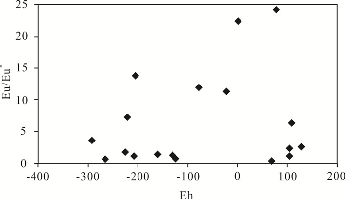
Shidian medium-low temperature geothermal system, which has a complicated reservoir structure due to the intense tectonic movement, is a critical part of the Yunnan–Sichuan-Tibet geothermal Province (YST) with few studies focusing on it. The goal of this research is to study the geochemical behavior of the rare earth elements (REEs) in the Shidian geothermal system in order to reveal the dominant hydrogeochemical processes in the carbonate geothermal reservoir. The results in this study show that most of the geothermal fluids are rich in LREEs, indicating an inheritance of REEs feature from the host rocks. The geothermal fluids also have Cerium (Ce), Europium (Eu) and Yttrium (Y) anomalies. Among which, the negative Ce anomalies are probably the result of interaction between geothermal water and carbonate rock or an indicator of paleo-oxic conditions. The positive Eu anomalies are ascribed to the dissolution of feldspar minerals, while the positive Y anomalies are caused by the preferential adsorption of Ho on carbonates during the transport of geothermal fluids. The calculation by PHREEQC shows that the dominant species of REEs in geothermal fluid are LnCO3+ and Ln(CO3)2‒. The content of LnCO3+ decreases with the increasing atomic number, in contrast, Ln(CO3)2‒ increases with the increasing atomic number. In addition, there are still some Ln3+, LnF2+, LnHCO32+ and LnSO4+ species with small amount in the geothermal fluid, which are controlled by the pH of water as well as F‒, HCO3‒, and SO42‒ content. REEs can provide important evidence for studying the hydrogeochemical processes in a geothermal system.
Shidian medium-low temperature geothermal system, which has a complicated reservoir structure due to the intense tectonic movement, is a critical part of the Yunnan–Sichuan-Tibet geothermal Province (YST) with few studies focusing on it. The goal of this research is to study the geochemical behavior of the rare earth elements (REEs) in the Shidian geothermal system in order to reveal the dominant hydrogeochemical processes in the carbonate geothermal reservoir. The results in this study show that most of the geothermal fluids are rich in LREEs, indicating an inheritance of REEs feature from the host rocks. The geothermal fluids also have Cerium (Ce), Europium (Eu) and Yttrium (Y) anomalies. Among which, the negative Ce anomalies are probably the result of interaction between geothermal water and carbonate rock or an indicator of paleo-oxic conditions. The positive Eu anomalies are ascribed to the dissolution of feldspar minerals, while the positive Y anomalies are caused by the preferential adsorption of Ho on carbonates during the transport of geothermal fluids. The calculation by PHREEQC shows that the dominant species of REEs in geothermal fluid are LnCO3+ and Ln(CO3)2‒. The content of LnCO3+ decreases with the increasing atomic number, in contrast, Ln(CO3)2‒ increases with the increasing atomic number. In addition, there are still some Ln3+, LnF2+, LnHCO32+ and LnSO4+ species with small amount in the geothermal fluid, which are controlled by the pH of water as well as F‒, HCO3‒, and SO42‒ content. REEs can provide important evidence for studying the hydrogeochemical processes in a geothermal system.


2023, 48(3): 923-934.
doi: 10.3799/dqkx.2022.164
Abstract:
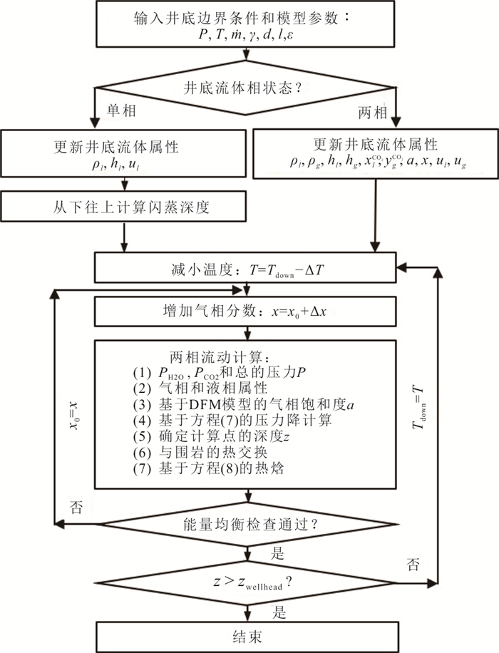
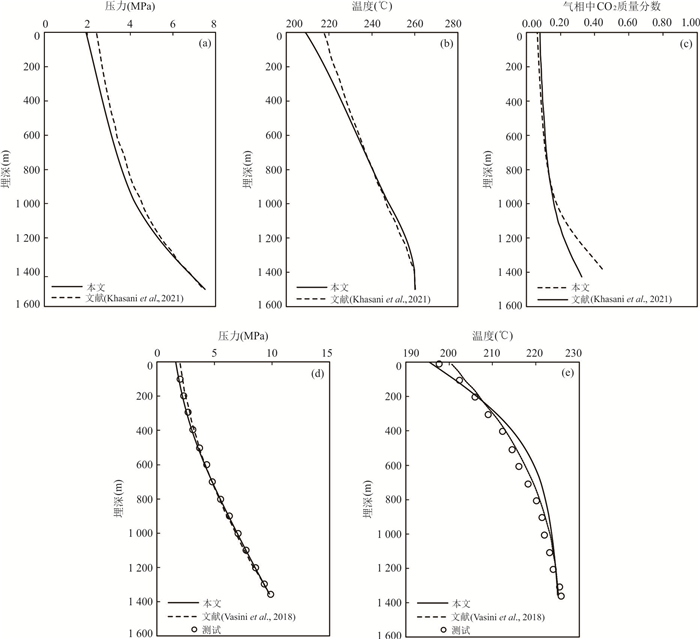
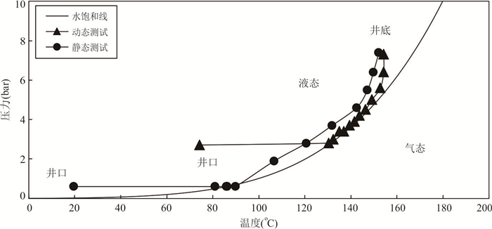
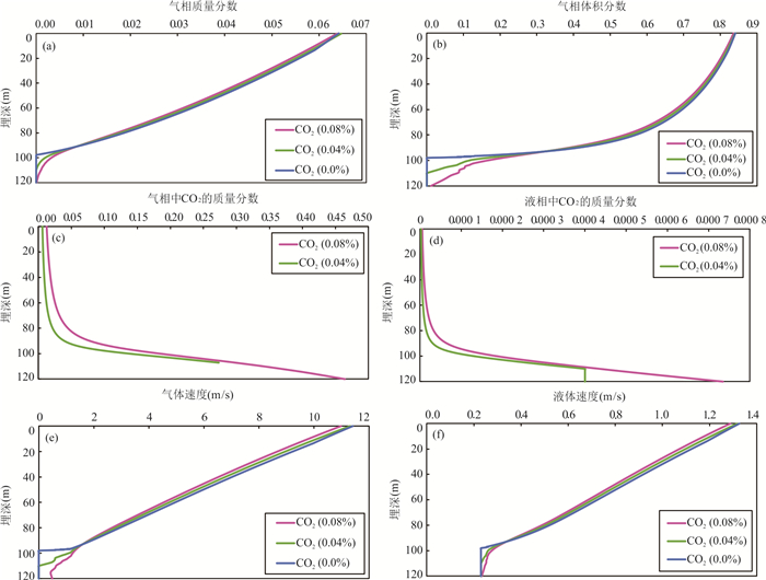
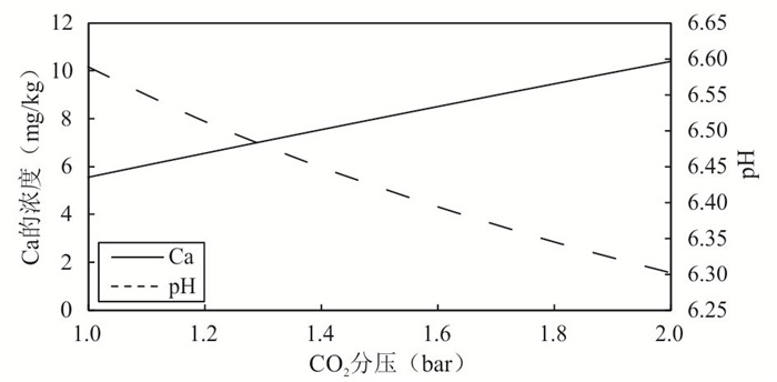
The quantitative evaluation of calcite scaling in high temperature geothermal production wells involves complex physical and chemical processes, in which the two-phase flow in the wellbore is the basis for the evaluation. Based on mass, energy and momentum conservations, this paper firstly constructs a model for governing the two-phase steady flow with phase transition in the presence of CO2 in the wellbore. A robust calculation method is presented and the calculation is validated. Then the temperature and pressure measurements in a typical geothermal well were carried out during discharge tests including static and dynamic test in the Yangbajing geothermal field, Tibet. Combined with the discharge test, the model is successfully used to evaluate the two-phase flow process in a high temperature production well. The results show that the velocity difference between the gas and liquid phase has a decisive impact on the profiles of temperature and pressure in the wellbore. If the velocity difference is not considered in the model, the calculations will deviate far from the measurements. At the production rate of 19.10 kg/s, the calculated wellhead temperature and pressure are about 128 ℃ and 2.6 bar, respectively. The wellhead gas mass fraction is between 6% and 7%, and the corresponding gas phase saturation is about 0.84. The CO2 mass fractions in both gas and liquid phases change sharply about 20-30 m up from the flash point, indicating that serious calcite scaling will occur in this well section.
The quantitative evaluation of calcite scaling in high temperature geothermal production wells involves complex physical and chemical processes, in which the two-phase flow in the wellbore is the basis for the evaluation. Based on mass, energy and momentum conservations, this paper firstly constructs a model for governing the two-phase steady flow with phase transition in the presence of CO2 in the wellbore. A robust calculation method is presented and the calculation is validated. Then the temperature and pressure measurements in a typical geothermal well were carried out during discharge tests including static and dynamic test in the Yangbajing geothermal field, Tibet. Combined with the discharge test, the model is successfully used to evaluate the two-phase flow process in a high temperature production well. The results show that the velocity difference between the gas and liquid phase has a decisive impact on the profiles of temperature and pressure in the wellbore. If the velocity difference is not considered in the model, the calculations will deviate far from the measurements. At the production rate of 19.10 kg/s, the calculated wellhead temperature and pressure are about 128 ℃ and 2.6 bar, respectively. The wellhead gas mass fraction is between 6% and 7%, and the corresponding gas phase saturation is about 0.84. The CO2 mass fractions in both gas and liquid phases change sharply about 20-30 m up from the flash point, indicating that serious calcite scaling will occur in this well section.


2023, 48(3): 935-945.
doi: 10.3799/dqkx.2022.163
Abstract:
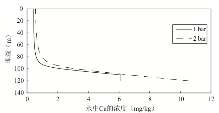
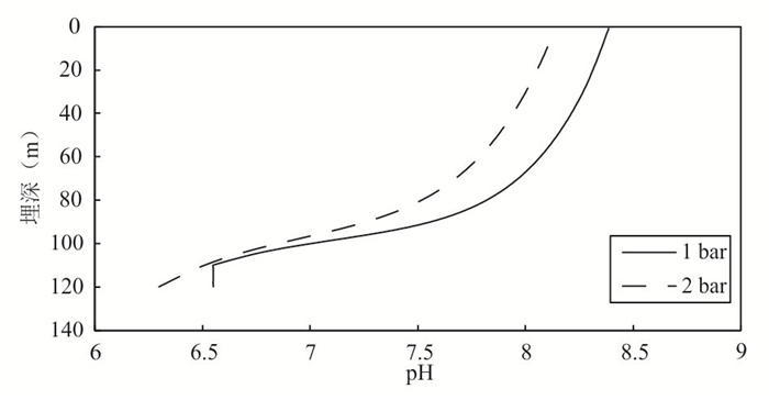
Wellbore scaling in high temperature geothermal fields is one of the prominent problems encountered in geothermal development, which involves complex hydrogeochemical processes. In this paper, a coupling model for quantitative assessment of wellbore scaling, including two-phase flow, hydrogeochemical reactions among water-gas-scaling minerals and wellbore adhesion, was established. The wellhead sampling for water, gas and mineral was carried out in typical geothermal wells in the Yangbajing geothermal field. The analysis results show that calcite is the dominant scaling-formed mineral. The geothermal fluid is supersaturated with respect to carbonate minerals. CO2 is the main non-condensable gas in the fluid. Finally, this paper evaluates the location and rate of calcite scaling based on the established model and measured fluid results. The results show that CO2 partial pressure has controlling effect on the precipitation of calcite. The maximum scaling thickness with 14-25 mm occurs 10-20 m above the flash depth for one-year production. Under the assumption that all the precipitation of calcite adheres to the wellbore wall, the scaling thickness is about 200 mm. The high CO2 content in the fluid results in greater thickness of scaling.
Wellbore scaling in high temperature geothermal fields is one of the prominent problems encountered in geothermal development, which involves complex hydrogeochemical processes. In this paper, a coupling model for quantitative assessment of wellbore scaling, including two-phase flow, hydrogeochemical reactions among water-gas-scaling minerals and wellbore adhesion, was established. The wellhead sampling for water, gas and mineral was carried out in typical geothermal wells in the Yangbajing geothermal field. The analysis results show that calcite is the dominant scaling-formed mineral. The geothermal fluid is supersaturated with respect to carbonate minerals. CO2 is the main non-condensable gas in the fluid. Finally, this paper evaluates the location and rate of calcite scaling based on the established model and measured fluid results. The results show that CO2 partial pressure has controlling effect on the precipitation of calcite. The maximum scaling thickness with 14-25 mm occurs 10-20 m above the flash depth for one-year production. Under the assumption that all the precipitation of calcite adheres to the wellbore wall, the scaling thickness is about 200 mm. The high CO2 content in the fluid results in greater thickness of scaling.


2023, 48(3): 946-957.
doi: 10.3799/dqkx.2022.310
Abstract:
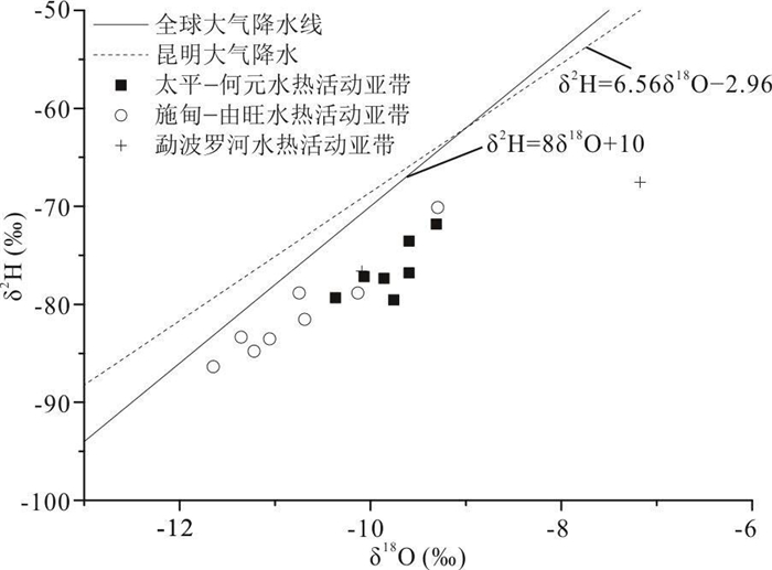
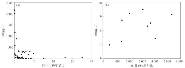
Antimony is a typical harmful element, and the negative environmental effects of antimony-rich hot springs discharge can not be neglected since geothermal genesis of antimony is an important source of antimony in the natural water environments. In this paper, the morphological distribution of antimony in hot springs and its geochemical genesis were analyzed in selected typical geothermal areas in southern Tibet and western Yunnan. In general, the antimony of geothermal water discharged from the study area can be up to 2 128.7 μg/L, which is much higher than the background values in the natural water environments. Hydrogeochemical calculations indicate that the main forms of antimony present in the hot springs are antimonate and antimonite, however, the percentage of thioantimony in some hot spring samples can be as high as 35% of the total antimony. Sulfide concentration, S(-Ⅱ)/Sb molar ratio, and competitive thiolation between arsenic and antimony are the key factors affecting the content of thioantimony in hot springs. Among the geothermal systems involved in this study, the Tibetan MapamYumco, Moincer, and Moluojiang are magma-heat geothermal systems, and the antimony in the geothermal water originates from the input of fluids released from the hot storage surrounding rocks leaching and magma house as the heat source under high temperature conditions, while the Tibetan Quzuomu, Langjiu and Yunnan Banglazhang are non-magma-heat geothermal systems, and the main source of antimony in their thermal springs is geothermal water-peripheral rock mineral interaction.
Antimony is a typical harmful element, and the negative environmental effects of antimony-rich hot springs discharge can not be neglected since geothermal genesis of antimony is an important source of antimony in the natural water environments. In this paper, the morphological distribution of antimony in hot springs and its geochemical genesis were analyzed in selected typical geothermal areas in southern Tibet and western Yunnan. In general, the antimony of geothermal water discharged from the study area can be up to 2 128.7 μg/L, which is much higher than the background values in the natural water environments. Hydrogeochemical calculations indicate that the main forms of antimony present in the hot springs are antimonate and antimonite, however, the percentage of thioantimony in some hot spring samples can be as high as 35% of the total antimony. Sulfide concentration, S(-Ⅱ)/Sb molar ratio, and competitive thiolation between arsenic and antimony are the key factors affecting the content of thioantimony in hot springs. Among the geothermal systems involved in this study, the Tibetan MapamYumco, Moincer, and Moluojiang are magma-heat geothermal systems, and the antimony in the geothermal water originates from the input of fluids released from the hot storage surrounding rocks leaching and magma house as the heat source under high temperature conditions, while the Tibetan Quzuomu, Langjiu and Yunnan Banglazhang are non-magma-heat geothermal systems, and the main source of antimony in their thermal springs is geothermal water-peripheral rock mineral interaction.


2023, 48(3): 958-972.
doi: 10.3799/dqkx.2022.385
Abstract:
The geochemical geothermometer is a common method for estimating the temperature of deep thermal reservoirs, which is widely used where no boreholes are drilled or the borehole depths do not reach the geothermal reservoir. However, the calculation results of the geochemical geothermometer were generally compared to the wellhead temperature in the previous studies. Comparison studies with the measured temperature of the borehole are few, which results in uncertainty of the geothermometers. In this study, 12 geothermal wells in the geothermal field with detailed research basis and abundant data in Xiong'an New Area, Jizhong depression, North China Plain, were selected to evaluate the reliability of the geothermometer in conjunction with water temperature measurement, borehole logging, and geothermal water collection and analysis. Nineteen geochemical geothermometers were used to estimate the thermal storage temperature of geothermal water after the evolution of water-rock interaction and multimineral thermodynamic equilibrium simulation. And then the results were compared with the measured borehole temperature and wellhead temperature. Results show that when the wellhead temperature in the study area is less than 70 ℃, the wellhead temperature falls within the range of the actual borehole temperature from the thermal reservoir roof to the floor. However, when the wellhead temperature exceeds 100 ℃, the wellhead temperature is lower than the thermal reservoir roof temperature and much lower to the bottom plate temperature. They are affected by several factors such as cooling, decompression, phase separation, CO2 degassing, and SiO2 precipitation during the transport process, which should be paid great attention in the future. Secondly, the geothermal water in Jixian karst-fissured reservoir belongs to immature water, and the cation geothermometer is not applicable, while the geothermal water in the porous Neogene sandstone reservoir is mainly located in a partial equilibrium area which implies the feasibility of both cation and SiO2 geothermometer. The borehole temperatures were used to verify the suitable geothermometers. It is found that the chalcedony solubility geothermometer is suitable for Jixian karst-fissured reservoir with a deviation of 6.2 ℃, while the Na-K geothermometer and chalcedony geothermometer are suitable for the porous Neogene sandstone reservoir with a deviation of 6.0 ℃ and 3.4 ℃, respectively. Finally, a variety of geothermometers are recommended to be selected with constraints of stratigraphic information, rock characteristics, wellhead temperature, and so on. And if the borehole logging is not available, underground temperature can be roughly understood with geochemical geothermometers at different sampling depths under the same geological structural unit. Our results have significant implications for the application of geochemical geothermometers and sustainable management of geothermal resources.
The geochemical geothermometer is a common method for estimating the temperature of deep thermal reservoirs, which is widely used where no boreholes are drilled or the borehole depths do not reach the geothermal reservoir. However, the calculation results of the geochemical geothermometer were generally compared to the wellhead temperature in the previous studies. Comparison studies with the measured temperature of the borehole are few, which results in uncertainty of the geothermometers. In this study, 12 geothermal wells in the geothermal field with detailed research basis and abundant data in Xiong'an New Area, Jizhong depression, North China Plain, were selected to evaluate the reliability of the geothermometer in conjunction with water temperature measurement, borehole logging, and geothermal water collection and analysis. Nineteen geochemical geothermometers were used to estimate the thermal storage temperature of geothermal water after the evolution of water-rock interaction and multimineral thermodynamic equilibrium simulation. And then the results were compared with the measured borehole temperature and wellhead temperature. Results show that when the wellhead temperature in the study area is less than 70 ℃, the wellhead temperature falls within the range of the actual borehole temperature from the thermal reservoir roof to the floor. However, when the wellhead temperature exceeds 100 ℃, the wellhead temperature is lower than the thermal reservoir roof temperature and much lower to the bottom plate temperature. They are affected by several factors such as cooling, decompression, phase separation, CO2 degassing, and SiO2 precipitation during the transport process, which should be paid great attention in the future. Secondly, the geothermal water in Jixian karst-fissured reservoir belongs to immature water, and the cation geothermometer is not applicable, while the geothermal water in the porous Neogene sandstone reservoir is mainly located in a partial equilibrium area which implies the feasibility of both cation and SiO2 geothermometer. The borehole temperatures were used to verify the suitable geothermometers. It is found that the chalcedony solubility geothermometer is suitable for Jixian karst-fissured reservoir with a deviation of 6.2 ℃, while the Na-K geothermometer and chalcedony geothermometer are suitable for the porous Neogene sandstone reservoir with a deviation of 6.0 ℃ and 3.4 ℃, respectively. Finally, a variety of geothermometers are recommended to be selected with constraints of stratigraphic information, rock characteristics, wellhead temperature, and so on. And if the borehole logging is not available, underground temperature can be roughly understood with geochemical geothermometers at different sampling depths under the same geological structural unit. Our results have significant implications for the application of geochemical geothermometers and sustainable management of geothermal resources.


2023, 48(3): 973-987.
doi: 10.3799/dqkx.2022.087
Abstract:
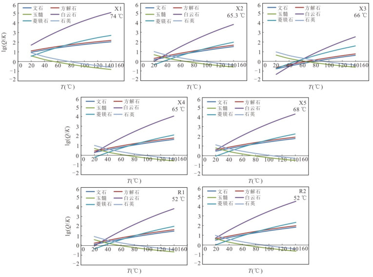
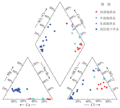
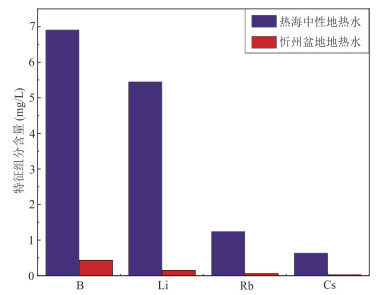
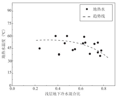
Studies on geothermal water geochemistry are of great significance for understanding the genesis of various hydrothermal resources. By taking the Xinzhou basin in Shanxi Province as a study area, this paper aims to identify the geochemical origin of the Xinzhou geothermal waters, to evaluate the mixing process between the geothermal waters and the shallow cold groundwaters, and to reveal the geological genesis of the Xinzhou geothermal system based on a systematic geochemical study conducted there. The formation of the Xinzhou geothermal system should have nothing to do with a shallow magma chamber or excessive decay heat of radioactive elements in shallow rocks. Instead, it occurred as a result of the deep groundwater circulation in a normal heat flow background. The atmospheric precipitation in the western Yunzhongshan recharge area infiltrated into the deep underground and migrated to the Xinzhou basin with circulation depths between 1 618.3 and 3 451.5 m. Correspondingly, the reservoir temperatures ranged from 48.4 to 91.8 ℃. The geothermal waters were mixed substantially with the shallow groundwaters when ascending to the Quaternary aquifers, the highest mixing ratio being up to 78 %.
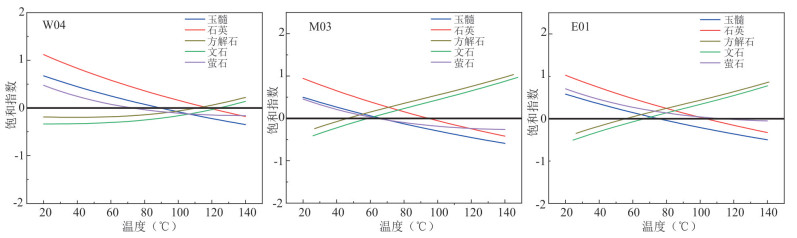
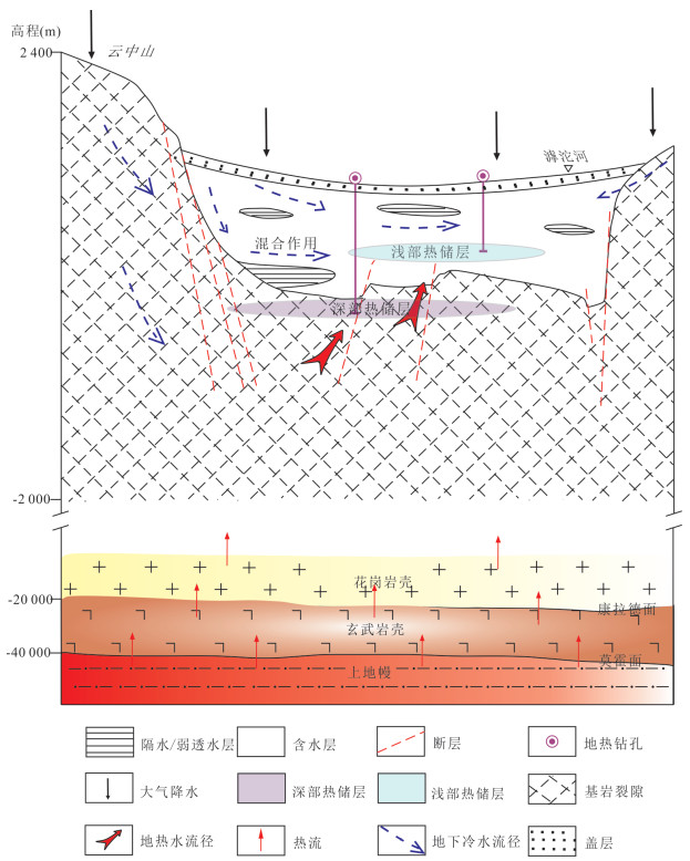
Studies on geothermal water geochemistry are of great significance for understanding the genesis of various hydrothermal resources. By taking the Xinzhou basin in Shanxi Province as a study area, this paper aims to identify the geochemical origin of the Xinzhou geothermal waters, to evaluate the mixing process between the geothermal waters and the shallow cold groundwaters, and to reveal the geological genesis of the Xinzhou geothermal system based on a systematic geochemical study conducted there. The formation of the Xinzhou geothermal system should have nothing to do with a shallow magma chamber or excessive decay heat of radioactive elements in shallow rocks. Instead, it occurred as a result of the deep groundwater circulation in a normal heat flow background. The atmospheric precipitation in the western Yunzhongshan recharge area infiltrated into the deep underground and migrated to the Xinzhou basin with circulation depths between 1 618.3 and 3 451.5 m. Correspondingly, the reservoir temperatures ranged from 48.4 to 91.8 ℃. The geothermal waters were mixed substantially with the shallow groundwaters when ascending to the Quaternary aquifers, the highest mixing ratio being up to 78 %.


2023, 48(3): 988-1001.
doi: 10.3799/dqkx.2022.070
Abstract:
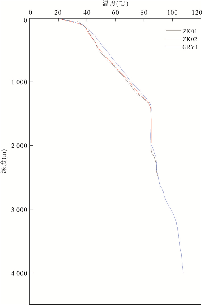
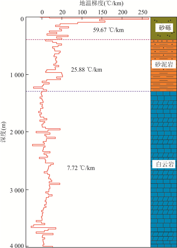
Understanding the lithospheric thermal structure is an important basis for understanding the continental dynamics (i.e., tectonic deformation and evolution) of the continental lithosphere. It is also the core of studies on the thermal source mechanisms of geothermal fields. Most importantly, it can provide scientific guidance for the exploration and development of deep geothermal resources. The Cangxian uplift enjoys rich geothermal resources and favorable geothermal geological conditions. However, its lithospheric thermal structure is still unclear, which restricts the exploration and development of regional geothermal resources. Focusing on the Xianxian geothermal field in the middle part of the Cangxian uplift through the temperature measurement of a 4 000 m deep well and fine tests of geotechnical thermophysical properties, this study has ascertained the characteristics of the terrestrial heat flow and lithospheric thermal structure in the study area, thus filling the gap in terrestrial heat flow measurement. Moreover, this study has established a conceptual model of the lithospheric thermal structure of the study area and estimated the deep temperature and lithospheric thickness in the study area. The results show that the Xianxian geothermal field has a heat flow of 70.58 mW/m2, a burial depth of the Curie surface of about 24 km, a Moho temperature of about 749 ℃, and a lithospheric thickness of about 85-96 km.
Understanding the lithospheric thermal structure is an important basis for understanding the continental dynamics (i.e., tectonic deformation and evolution) of the continental lithosphere. It is also the core of studies on the thermal source mechanisms of geothermal fields. Most importantly, it can provide scientific guidance for the exploration and development of deep geothermal resources. The Cangxian uplift enjoys rich geothermal resources and favorable geothermal geological conditions. However, its lithospheric thermal structure is still unclear, which restricts the exploration and development of regional geothermal resources. Focusing on the Xianxian geothermal field in the middle part of the Cangxian uplift through the temperature measurement of a 4 000 m deep well and fine tests of geotechnical thermophysical properties, this study has ascertained the characteristics of the terrestrial heat flow and lithospheric thermal structure in the study area, thus filling the gap in terrestrial heat flow measurement. Moreover, this study has established a conceptual model of the lithospheric thermal structure of the study area and estimated the deep temperature and lithospheric thickness in the study area. The results show that the Xianxian geothermal field has a heat flow of 70.58 mW/m2, a burial depth of the Curie surface of about 24 km, a Moho temperature of about 749 ℃, and a lithospheric thickness of about 85-96 km.


2023, 48(3): 1002-1013.
doi: 10.3799/dqkx.2022.134
Abstract:
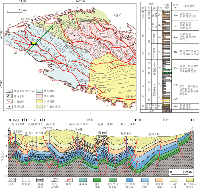
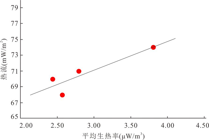
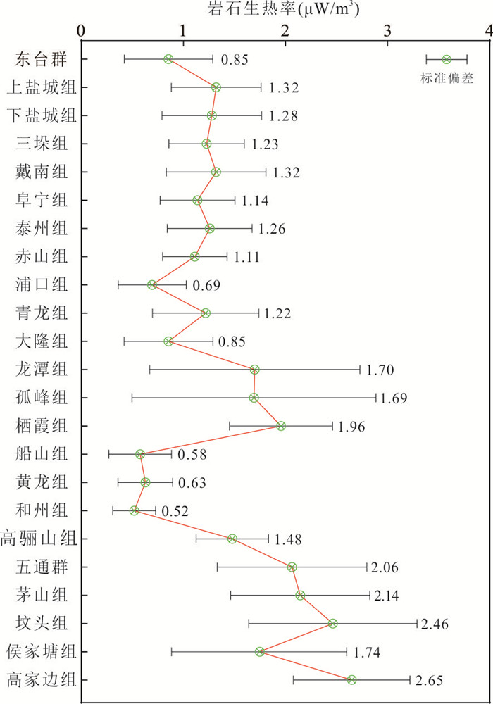
The Yingxiongling structural belt is one of the most important petroliferous areas in the Qaidam Basin. The geothermal field not only has an important influence on the oil and gas accumulation process,but also is an important reference for the implementation of oilfield development and other projects. Based on the temperature data by well oil-test and the measured thermal conductivity data,the present-day heat flow characteristics in the study area are studied. The geothermal gradient in the Yingdong area ranges from 31.8 to 35.3 ℃/km,with an average of 33.6 ℃/km. The thermal conductivity of Neogene rocks ranges from 1.8 to 2.4 W/m/K,with an average of 2.07 W/m/K. The calculated heat flow value is 65-74 mW/m2,and the average value is 69 mW/m2. The heat flow in the central and western parts of the Qaidam Basin is mainly characterized by "high in the west and low in the east" pattern. The heat flow in Kunbei,Nanyishan and Yiliping is generally greater than 65 mW/m2,while the heat flow in the front of the Altun Mountains,the Lenghu structural belt and the Sebei is relatively low. The heat flow is generally lower than 50 mW/m2 in Xianshuiquan and Lenghu. The measured average heat production rate is ca. 2.84 μW/m3,and the contribution rate to heat flow is about 20%. The study area has a relative thermal crust and warm mantle,and the heat flow is influenced by the large contribution of crustal radioactive heat production,the high U intrusive rocks of the sedimentary source area,the tectonic heat caused by the convergence of the Indian plate,and the thermal lithosphere thickness,etc..
The Yingxiongling structural belt is one of the most important petroliferous areas in the Qaidam Basin. The geothermal field not only has an important influence on the oil and gas accumulation process,but also is an important reference for the implementation of oilfield development and other projects. Based on the temperature data by well oil-test and the measured thermal conductivity data,the present-day heat flow characteristics in the study area are studied. The geothermal gradient in the Yingdong area ranges from 31.8 to 35.3 ℃/km,with an average of 33.6 ℃/km. The thermal conductivity of Neogene rocks ranges from 1.8 to 2.4 W/m/K,with an average of 2.07 W/m/K. The calculated heat flow value is 65-74 mW/m2,and the average value is 69 mW/m2. The heat flow in the central and western parts of the Qaidam Basin is mainly characterized by "high in the west and low in the east" pattern. The heat flow in Kunbei,Nanyishan and Yiliping is generally greater than 65 mW/m2,while the heat flow in the front of the Altun Mountains,the Lenghu structural belt and the Sebei is relatively low. The heat flow is generally lower than 50 mW/m2 in Xianshuiquan and Lenghu. The measured average heat production rate is ca. 2.84 μW/m3,and the contribution rate to heat flow is about 20%. The study area has a relative thermal crust and warm mantle,and the heat flow is influenced by the large contribution of crustal radioactive heat production,the high U intrusive rocks of the sedimentary source area,the tectonic heat caused by the convergence of the Indian plate,and the thermal lithosphere thickness,etc..


2023, 48(3): 1014-1029.
doi: 10.3799/dqkx.2022.150
Abstract:
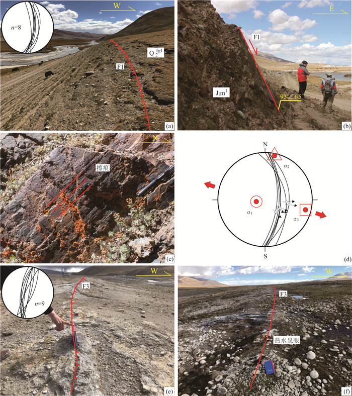
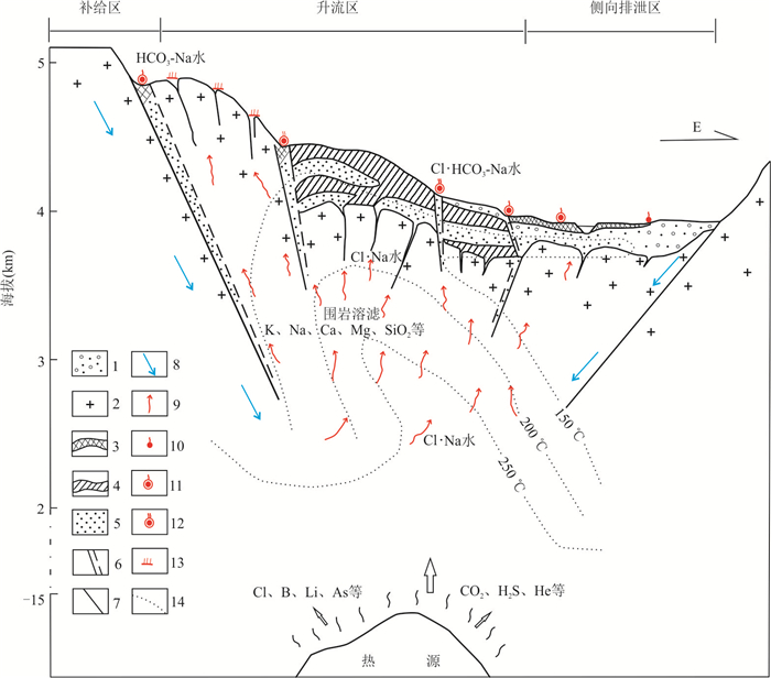
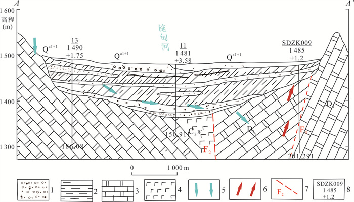
The Gulu geothermal field successfully revealed high temperature thermal reservoir of 189.2 ℃ in 2020, therefore, studying geothermal geological characteristics of the Gulu geothermal field can be significant for guiding geothermal development and helpful for revealing the high temperature geothermal system mechanism. Based on the structural geological survey, combined with the latest geophysical, drilling, and hydrological data, this paper summarizes the structural thermal control laws of the Gulu geothermal field by analyzing the internal connection of the structure-water-thermal cycle system, and establishes a conceptual model of the geothermal system. The faults of the Gulu geothermal field can be divided into 3 groups: N-S trending (F1, F3), E-W trending (F2, F4) and NE trending. Atmospheric precipitation and iceberg meltwater migrated deep along the Jiuzila-Sangxiong fault, and were heated by deep heat sources to form high-temperature geothermal fluids, and rose along the F1 fault at the edge of the basin. The hot water was blocked by the F2 and F4 faults near surface, converging into thermal reservoir, migrating and draining along the channel system which formed by the N-S and NE faults; The conglomerate cemented by sinter overlying the basement granite played a role in ensuring water and thermal insulation for thermal reservoir. The Quaternary sediments were very thin in geothermal field, and the thermal reservoir was mainly stored in the bedrock fissures. According to the results, the "Y"-shaped fault system formed by F1 and F3 faults is the main storage place for thermal reservoir, and these two faults can be regarded as the main target for deep geothermal exploration.
The Gulu geothermal field successfully revealed high temperature thermal reservoir of 189.2 ℃ in 2020, therefore, studying geothermal geological characteristics of the Gulu geothermal field can be significant for guiding geothermal development and helpful for revealing the high temperature geothermal system mechanism. Based on the structural geological survey, combined with the latest geophysical, drilling, and hydrological data, this paper summarizes the structural thermal control laws of the Gulu geothermal field by analyzing the internal connection of the structure-water-thermal cycle system, and establishes a conceptual model of the geothermal system. The faults of the Gulu geothermal field can be divided into 3 groups: N-S trending (F1, F3), E-W trending (F2, F4) and NE trending. Atmospheric precipitation and iceberg meltwater migrated deep along the Jiuzila-Sangxiong fault, and were heated by deep heat sources to form high-temperature geothermal fluids, and rose along the F1 fault at the edge of the basin. The hot water was blocked by the F2 and F4 faults near surface, converging into thermal reservoir, migrating and draining along the channel system which formed by the N-S and NE faults; The conglomerate cemented by sinter overlying the basement granite played a role in ensuring water and thermal insulation for thermal reservoir. The Quaternary sediments were very thin in geothermal field, and the thermal reservoir was mainly stored in the bedrock fissures. According to the results, the "Y"-shaped fault system formed by F1 and F3 faults is the main storage place for thermal reservoir, and these two faults can be regarded as the main target for deep geothermal exploration.


2023, 48(3): 1030-1039.
doi: 10.3799/dqkx.2022.314
Abstract:
In order to deeply understand the regional geothermal background in Zhejiang, the continuous temperature measurement data of 53 deep geothermal wells in Zhejiang are sorted out, and 110 groups of related rock thermal conductivity data are measured and collected. Finally, 23 new terrestrial heat flow values are screened and calculated, with an average 73.7 mW/m2 of 61.7- 87.9 mW/m2, which is higher than the national average. The results show that controlled by NE-trending and NW-trending deep faults, there are Jiaxing-Cixi-Ningbo high heat flow geothermal unit in northeast Zhejiang, Suichang-Lanxi-Pujiang high heat flow geothermal unit in southwestern Zhejiang and Anji-Xinchang-Wenling low heat flow geothermal unit in central Zhejiang. The distribution of the above geothermal units is highly consistent with that of large Cretaceous faulted basins and Cenozoic sedimentary basins, and the analysis may be closely related to modern crustal movement and tectonic activity.
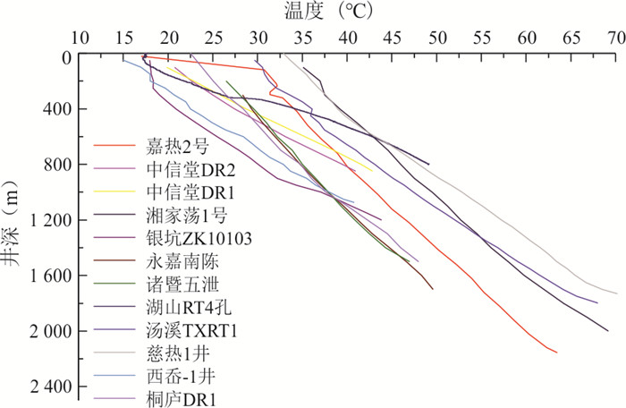
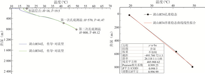
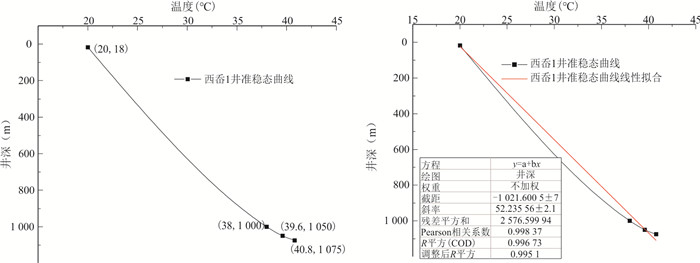
In order to deeply understand the regional geothermal background in Zhejiang, the continuous temperature measurement data of 53 deep geothermal wells in Zhejiang are sorted out, and 110 groups of related rock thermal conductivity data are measured and collected. Finally, 23 new terrestrial heat flow values are screened and calculated, with an average 73.7 mW/m2 of 61.7- 87.9 mW/m2, which is higher than the national average. The results show that controlled by NE-trending and NW-trending deep faults, there are Jiaxing-Cixi-Ningbo high heat flow geothermal unit in northeast Zhejiang, Suichang-Lanxi-Pujiang high heat flow geothermal unit in southwestern Zhejiang and Anji-Xinchang-Wenling low heat flow geothermal unit in central Zhejiang. The distribution of the above geothermal units is highly consistent with that of large Cretaceous faulted basins and Cenozoic sedimentary basins, and the analysis may be closely related to modern crustal movement and tectonic activity.


2023, 48(3): 1040-1057.
doi: 10.3799/dqkx.2023.044
Abstract:
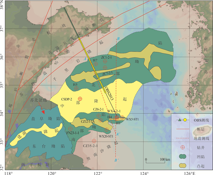
The study of lithosphere thermal structure state can not only understand the deep dynamic evolution mechanism of the lithosphere, but also be an important part of the evaluation of oil and gas resources in oil-bearing areas. The lack of heat generation rate data in the South Yellow Sea basin gets in the way of the research progress of lithospheric thermal structure. In this paper, the heat generation rate of sedimentary strata in the South Yellow Sea basin is calculated by the empirical relationship of GR (gamma value)-A (rock heat generation rate). Under the constraints of the terrestrial heat flow, the formation heat generation rate, the two-dimensional multi-channel seismic profile that passes through the basin in the south-north direction and the crust velocity structure profile OBS2013, the crust heat generation model of the South Yellow Sea basin was established, and the lithospheric thermal structure of the basin was calculated. The calculated results of lithospheric thermal structure show that: (1) the Moho average temperature of the three sub-units of the north depression, the central uplift and the south depression of the South Yellow Sea basin are 602.2±15.25 ℃, 592.7±2.56 ℃ and 650.6±20.24 ℃, respectively; (2) The average thermal lithosphere thickness is 99.7±2.20 km, 101.7±0.51 km, 88.2±2.49 km; (3) The crust-mantle heat flux ratios are 0.76±0.02, 0.88±0.01, and 0.71±0.15, respectively, with the characteristics of "cold crust and hot mantle". The results of this paper reveal that the South Yellow Sea basin not only has a high heat flow background, but also is in the transition stage from tectonic active area to tectonic stable area. In addition, the different lithospheric thermal structure characteristics of the three sub-units in the present South Yellow Sea basin may be related to the tectonic setting of the para-foreland basin formed on the south side of the Sulu orogenic belt (present northern depression) by the subduction collision of the Yangtze block and the North China block in the Late Triassic.
The study of lithosphere thermal structure state can not only understand the deep dynamic evolution mechanism of the lithosphere, but also be an important part of the evaluation of oil and gas resources in oil-bearing areas. The lack of heat generation rate data in the South Yellow Sea basin gets in the way of the research progress of lithospheric thermal structure. In this paper, the heat generation rate of sedimentary strata in the South Yellow Sea basin is calculated by the empirical relationship of GR (gamma value)-A (rock heat generation rate). Under the constraints of the terrestrial heat flow, the formation heat generation rate, the two-dimensional multi-channel seismic profile that passes through the basin in the south-north direction and the crust velocity structure profile OBS2013, the crust heat generation model of the South Yellow Sea basin was established, and the lithospheric thermal structure of the basin was calculated. The calculated results of lithospheric thermal structure show that: (1) the Moho average temperature of the three sub-units of the north depression, the central uplift and the south depression of the South Yellow Sea basin are 602.2±15.25 ℃, 592.7±2.56 ℃ and 650.6±20.24 ℃, respectively; (2) The average thermal lithosphere thickness is 99.7±2.20 km, 101.7±0.51 km, 88.2±2.49 km; (3) The crust-mantle heat flux ratios are 0.76±0.02, 0.88±0.01, and 0.71±0.15, respectively, with the characteristics of "cold crust and hot mantle". The results of this paper reveal that the South Yellow Sea basin not only has a high heat flow background, but also is in the transition stage from tectonic active area to tectonic stable area. In addition, the different lithospheric thermal structure characteristics of the three sub-units in the present South Yellow Sea basin may be related to the tectonic setting of the para-foreland basin formed on the south side of the Sulu orogenic belt (present northern depression) by the subduction collision of the Yangtze block and the North China block in the Late Triassic.


2023, 48(3): 1058-1079.
doi: 10.3799/dqkx.2022.179
Abstract:
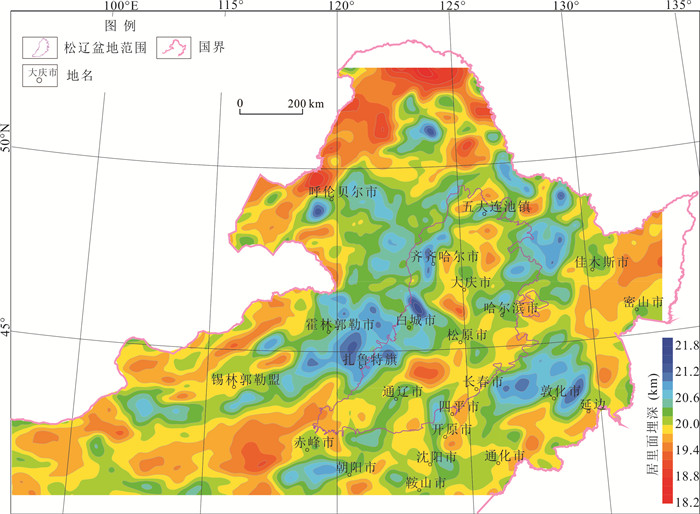
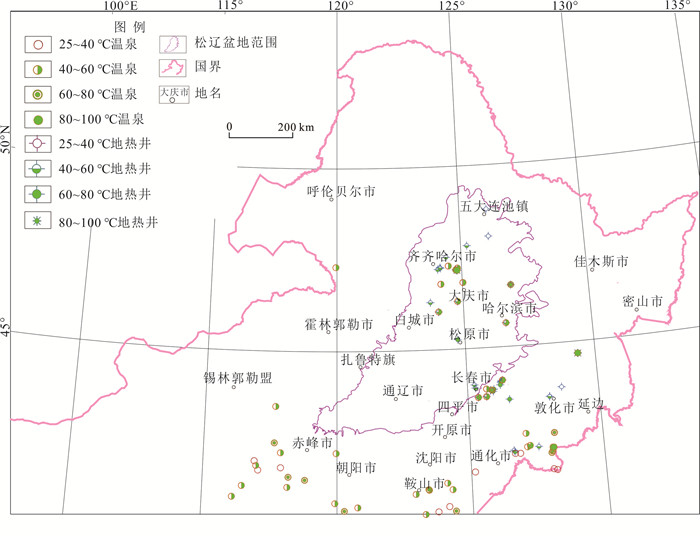
With the high heat flow values and high geothermal gradient values, the Songliao basin is considered as a favorable geothermal resources potential area in China. Although some important developments have been made in previous studies on hot dry rocks in the Songliao basin, there is a lack of important parameters in some domains (such as terrestrial heat flow, geothermal gradient), and there are still controversies over the favorable areas of geothermal resources due to the colletion-based major evaluation data. In this paper, based on a large number of geophysical data, the buried depth of high conductivity layers in the crust, the depth of curie point isotherm, the Moho buried depth and the lithology distribution on Mesozoic base were obtained. Meanwhile, the collected data was integrated, including heat flow, geothermal gradient, earthquake magnitude and the distribution of surface hot springs and geothermal wells. Finally, using the method of fuzzy mathematics, the deep geothermal resources potential in the Songliao basin is evaluated. The main results are as follows: The distribution characteristics of deep geothermal resources in the Songliao basin are "excellent in the middle, good in the southeast, poor in the west and north"; Two favorable areas for deep geothermal resources are obtained, with one of Daqing-Songyuan area, and the other of Zhaodong-Harbin area; The total resources of hot dry rock in the two favorable areas are about 6.236×10²² J(equivalent to 2.128×10¹² tce), which indicates that there is great resource potential of hot dry rock in the basin.
With the high heat flow values and high geothermal gradient values, the Songliao basin is considered as a favorable geothermal resources potential area in China. Although some important developments have been made in previous studies on hot dry rocks in the Songliao basin, there is a lack of important parameters in some domains (such as terrestrial heat flow, geothermal gradient), and there are still controversies over the favorable areas of geothermal resources due to the colletion-based major evaluation data. In this paper, based on a large number of geophysical data, the buried depth of high conductivity layers in the crust, the depth of curie point isotherm, the Moho buried depth and the lithology distribution on Mesozoic base were obtained. Meanwhile, the collected data was integrated, including heat flow, geothermal gradient, earthquake magnitude and the distribution of surface hot springs and geothermal wells. Finally, using the method of fuzzy mathematics, the deep geothermal resources potential in the Songliao basin is evaluated. The main results are as follows: The distribution characteristics of deep geothermal resources in the Songliao basin are "excellent in the middle, good in the southeast, poor in the west and north"; Two favorable areas for deep geothermal resources are obtained, with one of Daqing-Songyuan area, and the other of Zhaodong-Harbin area; The total resources of hot dry rock in the two favorable areas are about 6.236×10²² J(equivalent to 2.128×10¹² tce), which indicates that there is great resource potential of hot dry rock in the basin.


2023, 48(3): 1080-1092.
doi: 10.3799/dqkx.2022.324
Abstract:
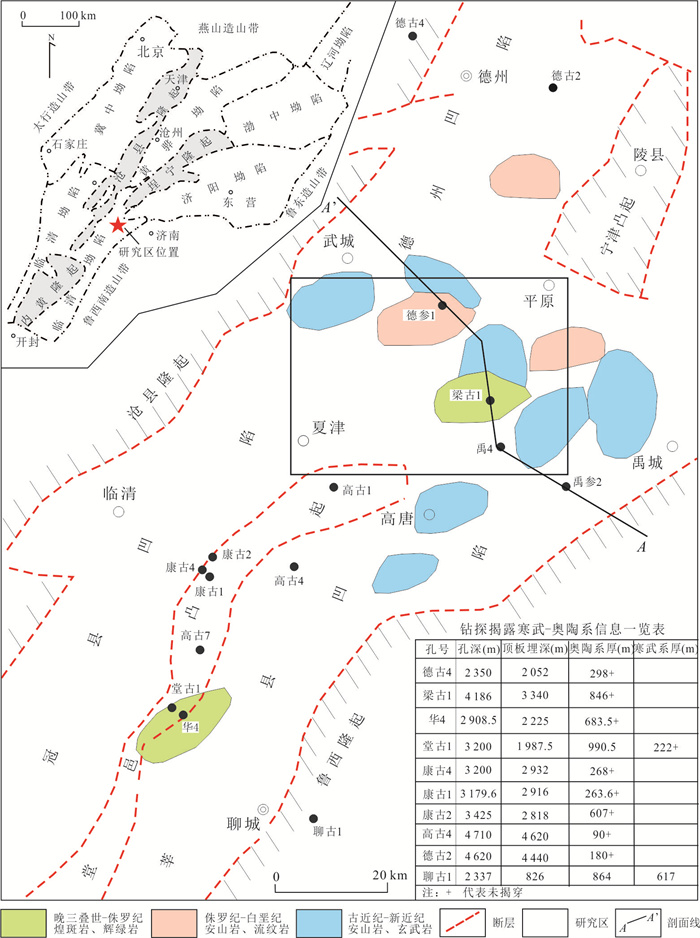
Geothermal energy is a green and low-carbon clean energy, and its large-scale development and utilization to replace fossil energy is of great significance to reduce carbon emissions and improve the atmospheric environment. In order to promote the geothermal electricity production by low-median temperature geothermal resources, and to fulfill the goal of carbon peak and carbon neutrality, this paper evaluated the resource sufficiency for a 10 MW geothermal power plant demonstration project based on the heat accumulation mechanism and geothermal resources potential of the karst reservoir in Liangcun buried uplift. Based on the correlation analysis between geothermal gradient, heat flow value and concave-convex structural lattice, thermal conductivity of rocks, together with the combination relationship study between karst development characteristics, thermal water abundance and structure, lithology, hydrodynamic conditions, the four-sources heat accumulation mechanism of the karst reservoir in Liangcun buried uplift is revealed as: the first source is high terrestrial heat flux caused by the destruction of north China Craton and lithosphere thinning, the second source is the thermal accumulation of the high thermal conductivity diffluence in the uplift area, the third source is the belt shaped convective thermal accumulation in the deep fault zone, and the fourth source is convective heat flow accumulation of diagenetic compaction water. Furthermore, the available heat resources and geothermal water resources in the Cambrian-Ordovician karst reservoir in Liangcun buried uplift are estimated to be 2.218 3×10¹⁹ J and 6.34×10⁹ m3, respectively. Driven by four-sources heat accumulation, the Liangcun buried uplift karst geothermal field with high thermal gradient was formed, and its thermal energy and geothermal water resources met the demand of 10 MW geothermal power station.
Geothermal energy is a green and low-carbon clean energy, and its large-scale development and utilization to replace fossil energy is of great significance to reduce carbon emissions and improve the atmospheric environment. In order to promote the geothermal electricity production by low-median temperature geothermal resources, and to fulfill the goal of carbon peak and carbon neutrality, this paper evaluated the resource sufficiency for a 10 MW geothermal power plant demonstration project based on the heat accumulation mechanism and geothermal resources potential of the karst reservoir in Liangcun buried uplift. Based on the correlation analysis between geothermal gradient, heat flow value and concave-convex structural lattice, thermal conductivity of rocks, together with the combination relationship study between karst development characteristics, thermal water abundance and structure, lithology, hydrodynamic conditions, the four-sources heat accumulation mechanism of the karst reservoir in Liangcun buried uplift is revealed as: the first source is high terrestrial heat flux caused by the destruction of north China Craton and lithosphere thinning, the second source is the thermal accumulation of the high thermal conductivity diffluence in the uplift area, the third source is the belt shaped convective thermal accumulation in the deep fault zone, and the fourth source is convective heat flow accumulation of diagenetic compaction water. Furthermore, the available heat resources and geothermal water resources in the Cambrian-Ordovician karst reservoir in Liangcun buried uplift are estimated to be 2.218 3×10¹⁹ J and 6.34×10⁹ m3, respectively. Driven by four-sources heat accumulation, the Liangcun buried uplift karst geothermal field with high thermal gradient was formed, and its thermal energy and geothermal water resources met the demand of 10 MW geothermal power station.


2023, 48(3): 1093-1106.
doi: 10.3799/dqkx.2022.200
Abstract:
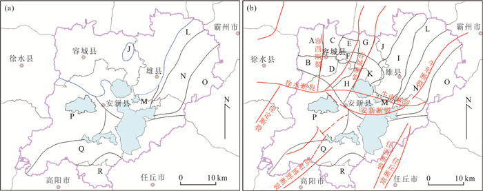
Analysis of the formation of geothermal resources and accurate assessment of the amount of geothermal resources are of great significance for the scientific and sustainable development and utilization of geothermal resources in Xiong'an New Area and achievement of carbon neutrality. This paper analyses the spatial distribution range and geothermal reserve characteristics of Guantao Formation, Cambrian System, Wumishan Formation and Gaoyuzhuang Formation in the geothermal field by studying data from 26 geothermal exploration wells including water quality analysis and mining tests in the Xiong'an New Area, and evaluates the geothermal resources of the Xiong'an New Area using the recoverable coefficient method and the equilibrium method of extraction-reinjection. The results show that the recoverable resources and heat calculated by the balanced extraction and reinjection method are much larger than those by the extraction coefficient method. The balanced extraction and reinjection method is closer to the actual development conditions and verified by the comparison method. The recoverable resources of geothermal fluids in the whole area under the balanced extraction and reinjection conditions are 401.77×10⁶ m3/a, and the recoverable heat of geothermal fluids is 1 013.2×10¹⁴ J/a, equivalent to 346.99×10⁴ t standard coal/year. This study will optimise the zoning of geothermal resources in the new area and promote the achievement of goal of "carbon peaking and carbon neutrality".
Analysis of the formation of geothermal resources and accurate assessment of the amount of geothermal resources are of great significance for the scientific and sustainable development and utilization of geothermal resources in Xiong'an New Area and achievement of carbon neutrality. This paper analyses the spatial distribution range and geothermal reserve characteristics of Guantao Formation, Cambrian System, Wumishan Formation and Gaoyuzhuang Formation in the geothermal field by studying data from 26 geothermal exploration wells including water quality analysis and mining tests in the Xiong'an New Area, and evaluates the geothermal resources of the Xiong'an New Area using the recoverable coefficient method and the equilibrium method of extraction-reinjection. The results show that the recoverable resources and heat calculated by the balanced extraction and reinjection method are much larger than those by the extraction coefficient method. The balanced extraction and reinjection method is closer to the actual development conditions and verified by the comparison method. The recoverable resources of geothermal fluids in the whole area under the balanced extraction and reinjection conditions are 401.77×10⁶ m3/a, and the recoverable heat of geothermal fluids is 1 013.2×10¹⁴ J/a, equivalent to 346.99×10⁴ t standard coal/year. This study will optimise the zoning of geothermal resources in the new area and promote the achievement of goal of "carbon peaking and carbon neutrality".


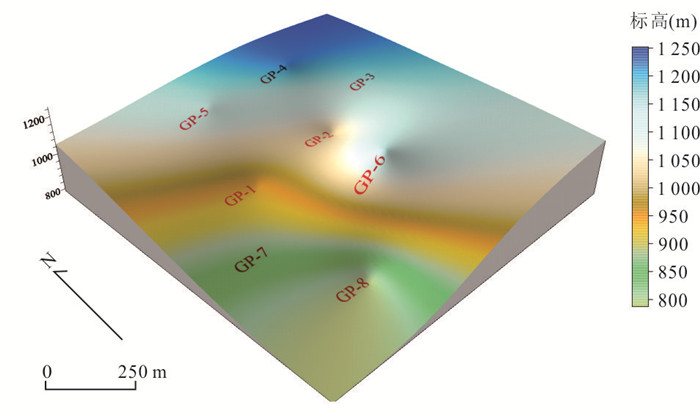
Geothermal Resources Evaluation Based on 3D Geological Modeling: The Case of Shidian Geothermal Area
2023, 48(3): 1107-1117.
doi: 10.3799/dqkx.2022.343
Abstract:
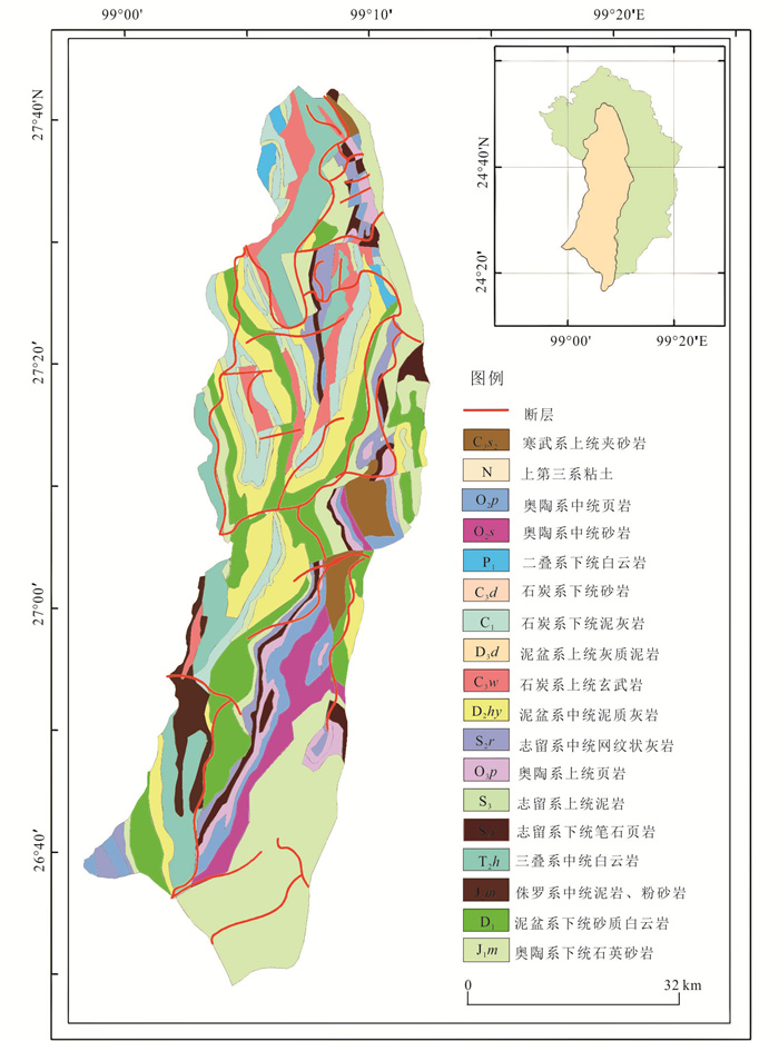
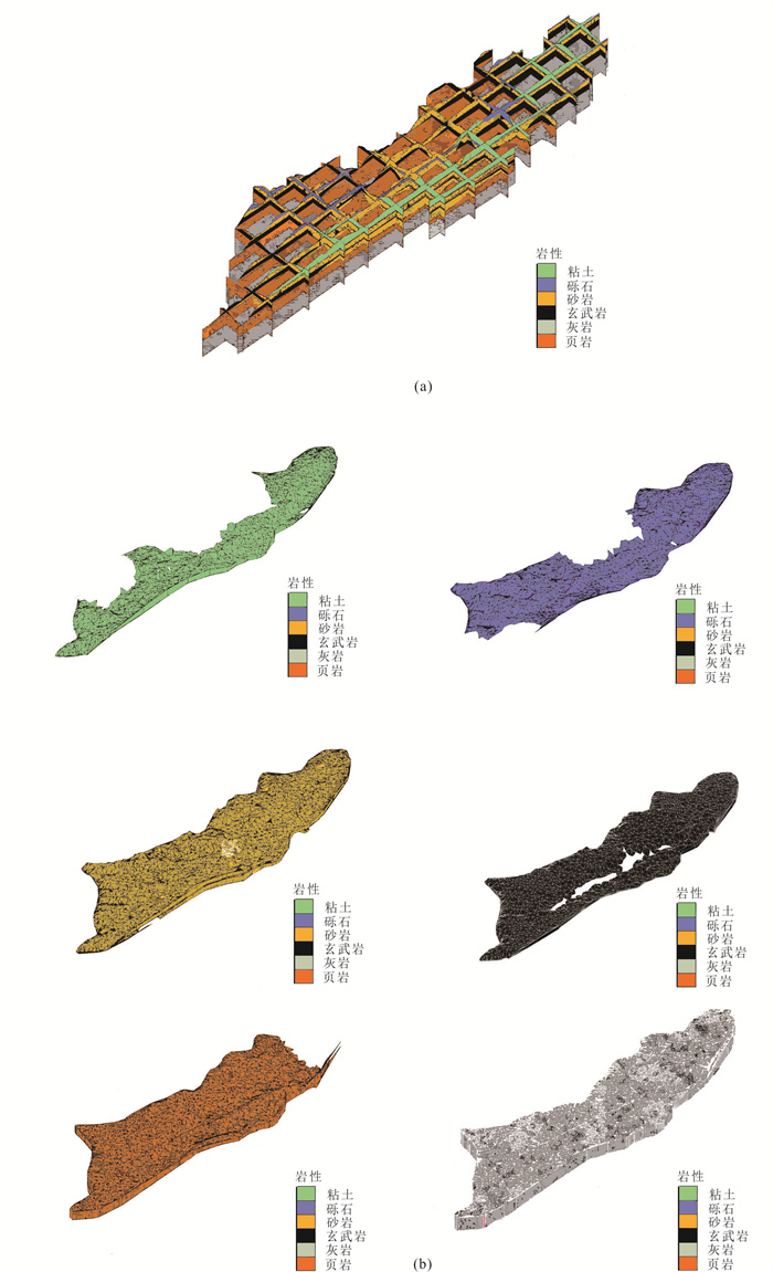
Although it is simple to evaluate geothermal resources using the traditional thermal reservoir method, the deviation of the evaluation results is usually large. Taking the Shidian geothermal field as a typical study area, a 3D geological model showing the distribution of geothermal reservoirs and caprocks in the area was built, using GMS software on the basis of geological and geothermal geological conditions in the region, combined with geophysical and drilling data. Considering the differences in the evaluation parameters of geothermal resources, the study area is divided into 9 sub-areas according to the thermal storage temperature, and the thermal reservoir volume is calculated in combination with the established three-dimensional geological model, and the improved thermal storage method is used to accurately and dynamically evaluate the study area. The heat stored in geothermal waters of the study area was calculated to be 1.38×10¹⁷ J, the heat stored in thermal storage rocks was 1.49×10¹⁹ J, and the total geothermal resources was 1.5×10¹⁹ J. According to the calculation results of the extractable amount of geothermal water, as well as the reasonable development and utilization of geothermal water resources in Shidian, 4.36×10⁷ t of standard coal can be saved annually. This study provides a new mode for the scientific and rational evaluation of geothermal resources in Shidian.
Although it is simple to evaluate geothermal resources using the traditional thermal reservoir method, the deviation of the evaluation results is usually large. Taking the Shidian geothermal field as a typical study area, a 3D geological model showing the distribution of geothermal reservoirs and caprocks in the area was built, using GMS software on the basis of geological and geothermal geological conditions in the region, combined with geophysical and drilling data. Considering the differences in the evaluation parameters of geothermal resources, the study area is divided into 9 sub-areas according to the thermal storage temperature, and the thermal reservoir volume is calculated in combination with the established three-dimensional geological model, and the improved thermal storage method is used to accurately and dynamically evaluate the study area. The heat stored in geothermal waters of the study area was calculated to be 1.38×10¹⁷ J, the heat stored in thermal storage rocks was 1.49×10¹⁹ J, and the total geothermal resources was 1.5×10¹⁹ J. According to the calculation results of the extractable amount of geothermal water, as well as the reasonable development and utilization of geothermal water resources in Shidian, 4.36×10⁷ t of standard coal can be saved annually. This study provides a new mode for the scientific and rational evaluation of geothermal resources in Shidian.


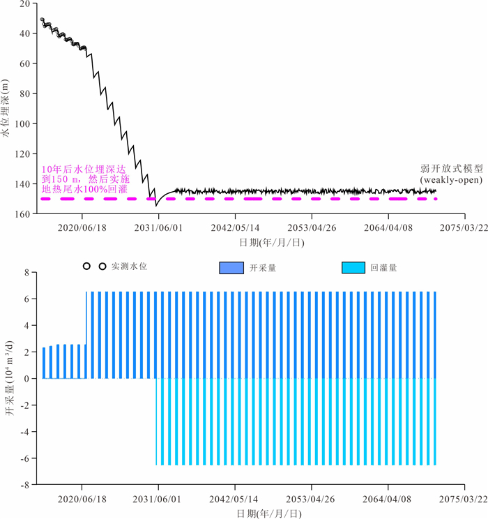
2023, 48(3): 1118-1137.
doi: 10.3799/dqkx.2022.448
Abstract:
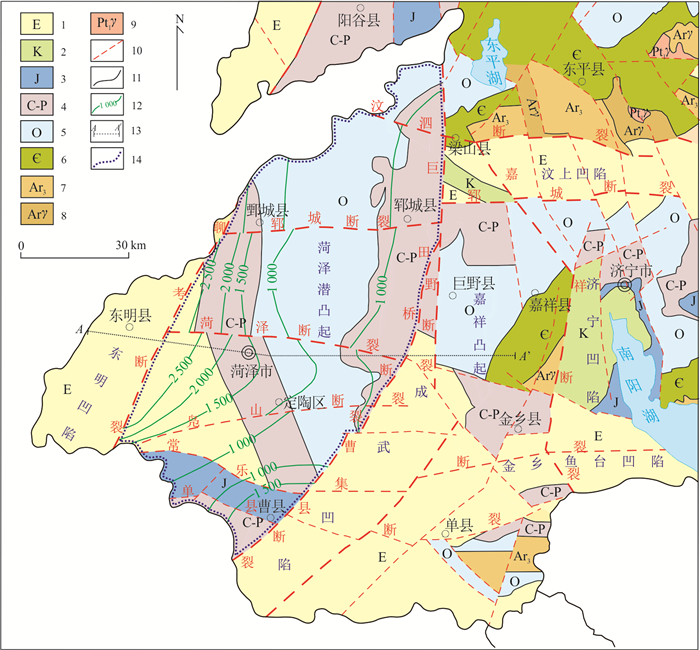
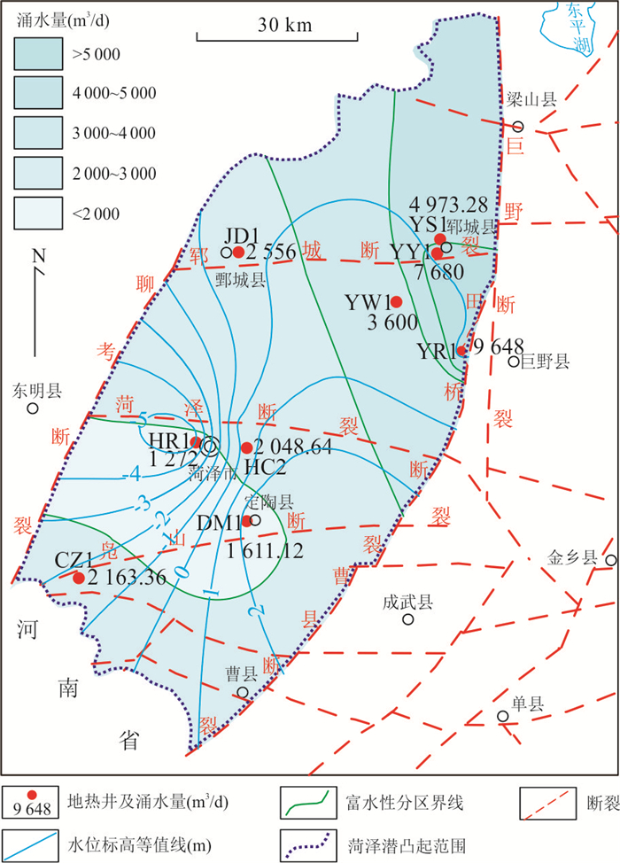
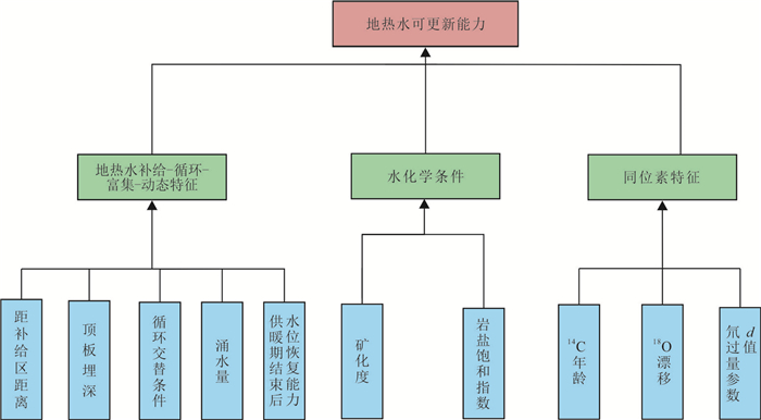
The renewable capacity of geothermal water and production-reinjection balanced resources evaluation of karst geothermal fields are the key issues of sustainable exploitation of geothermal energy. In order to evaluate the research more scientifically, this paper takes the Heze buried uplift geothermal field as an example, and takes the cycle enrichment, development dynamics, hydro-chemical and isotope characteristics of geothermal water as the controlling factors to establish an evaluation index system to comprehensively evaluate the renewable capacity of karst reservoir geothermal resources. The calculation method of sustainable yield of geothermal water is put forward under the prerequisite of production-reinjection balance, i.e. under the condition of geothermal water equilibrium and heat energy equilibrium. Then, the sustainable yield of geothermal water in the concentrated exploitation area of the geothermal field is evaluated. The renewability of geothermal water in the Heze buried uplift geothermal field is divided into four districts: strong, relatively strong, medium and poor. The strong region is distributed in the recharge area in the northeastern part of the geothermal field near the Liang mountain and Jiaxiang; the poor region is distributed in the discharge area around Dingtao-Heze urban area in the central and southern part of the geothermal field. In the recharge area and near the fault zones, the fissures and karstifications are developed strongly, and the water abundance of the geothermal reservoir is rich. On the contrary, far away from the recharge area and the fault zones, the fissures and karstifications are developed weakly, and the water abundance is poor. Under the production-reinjection balanced condition, the sustainable yield of geothermal resources is evaluated to be 122 600 m3/d in the concentrated exploitation area, which is 2.49 times as much as under the natural condition.
The renewable capacity of geothermal water and production-reinjection balanced resources evaluation of karst geothermal fields are the key issues of sustainable exploitation of geothermal energy. In order to evaluate the research more scientifically, this paper takes the Heze buried uplift geothermal field as an example, and takes the cycle enrichment, development dynamics, hydro-chemical and isotope characteristics of geothermal water as the controlling factors to establish an evaluation index system to comprehensively evaluate the renewable capacity of karst reservoir geothermal resources. The calculation method of sustainable yield of geothermal water is put forward under the prerequisite of production-reinjection balance, i.e. under the condition of geothermal water equilibrium and heat energy equilibrium. Then, the sustainable yield of geothermal water in the concentrated exploitation area of the geothermal field is evaluated. The renewability of geothermal water in the Heze buried uplift geothermal field is divided into four districts: strong, relatively strong, medium and poor. The strong region is distributed in the recharge area in the northeastern part of the geothermal field near the Liang mountain and Jiaxiang; the poor region is distributed in the discharge area around Dingtao-Heze urban area in the central and southern part of the geothermal field. In the recharge area and near the fault zones, the fissures and karstifications are developed strongly, and the water abundance of the geothermal reservoir is rich. On the contrary, far away from the recharge area and the fault zones, the fissures and karstifications are developed weakly, and the water abundance is poor. Under the production-reinjection balanced condition, the sustainable yield of geothermal resources is evaluated to be 122 600 m3/d in the concentrated exploitation area, which is 2.49 times as much as under the natural condition.


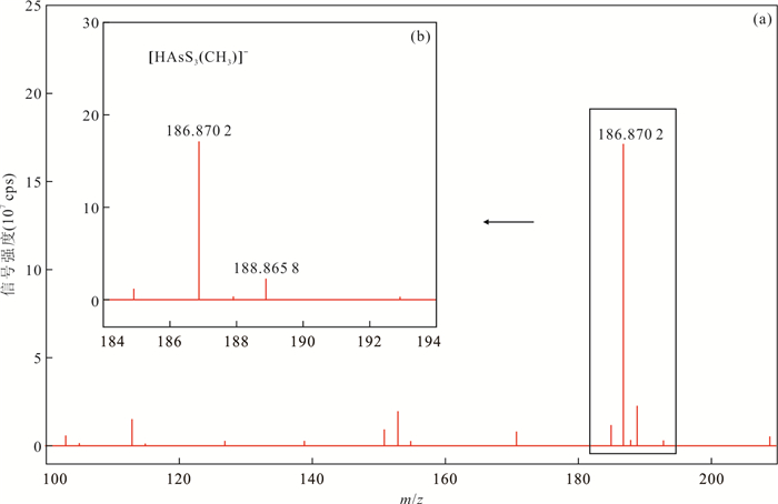
2023, 48(3): 1138-1145.
doi: 10.3799/dqkx.2022.250
Abstract:
Geothermal waters generally have far higher arsenic concentrations than other types of natural waters, and analysis of arsenic speciation in geothermal waters is of great environmental geochemical significance. Methylthiolated arsenates are non-negligible arsenic species under special aqueous environmental conditions, while little environmental geochemical studies of methylthiolated arsenates have been done so far. In this work, various methylthiolated arsenates standards were synthesized, and an ion chromatography coupled to inductively coupled plasma-mass spectrometry, capable of determining concentrations of common arsenic species as well as methylthiolated arsenates in natural waters including monomethylmonothioarsenate (MMMTA), monomethyldithioarsenate (MMDTA), monomethyltrithioarsenate (MMTTA), dimethylmonothioarsenate (DMMTA), and dimethyldithioarsenate (DMDTA), was set up. Furthermore, the arsenic speciation in a typical geothermal water sample was analyzed. The efforts made in this study produced an analytical method basis for future geochemical studies of methylthiolated arsenates in aqueous environments.
Geothermal waters generally have far higher arsenic concentrations than other types of natural waters, and analysis of arsenic speciation in geothermal waters is of great environmental geochemical significance. Methylthiolated arsenates are non-negligible arsenic species under special aqueous environmental conditions, while little environmental geochemical studies of methylthiolated arsenates have been done so far. In this work, various methylthiolated arsenates standards were synthesized, and an ion chromatography coupled to inductively coupled plasma-mass spectrometry, capable of determining concentrations of common arsenic species as well as methylthiolated arsenates in natural waters including monomethylmonothioarsenate (MMMTA), monomethyldithioarsenate (MMDTA), monomethyltrithioarsenate (MMTTA), dimethylmonothioarsenate (DMMTA), and dimethyldithioarsenate (DMDTA), was set up. Furthermore, the arsenic speciation in a typical geothermal water sample was analyzed. The efforts made in this study produced an analytical method basis for future geochemical studies of methylthiolated arsenates in aqueous environments.


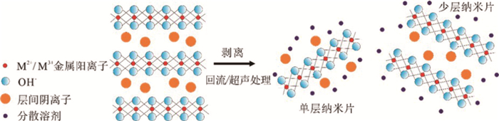
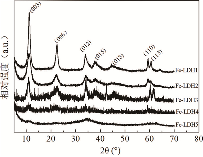
2023, 48(3): 1146-1155.
doi: 10.3799/dqkx.2022.342
Abstract:
Geothermal waters are generally enriched in multiple groups of harmful components, which threaten the safety of drinking water for the surrounding residents when non-concentrated discharged in the form of hot springs. In this paper, five iron-based LDH (Fe-LDH) modified materials were prepared and used in the treatment of hot springs in typical geothermal areas of Yunnan. The results show that Fe-LDH has the best removal of arsenic, followed by fluoride and tungsten, and the removal of antimony and boron was influenced by coexisting ions; whereas, the modified materials effectively narrow the gap of competitive sorption between different harmful components, which shows that ion exchange capacity of the lactate intercalated Fe-LDH was significantly improved and the removal of fluorine and boron was enhanced, while the delaminated Fe-LDHs exposed more active sites and increased the interlayer contact, thus it had a greater enhancement on the removal of arsenic and tungsten, which are primarily complexed with iron, along with the removal of fluoride and boron by ion exchange. Finally, the best sorbent in static sorption performance, L-asparagine delaminated Fe-LDH, could dynamically and effectively remove multiple groups of harmful components from hot springs as a filling material for small water treatment devices, which provides a practical method for the remediation of geothermal waters.
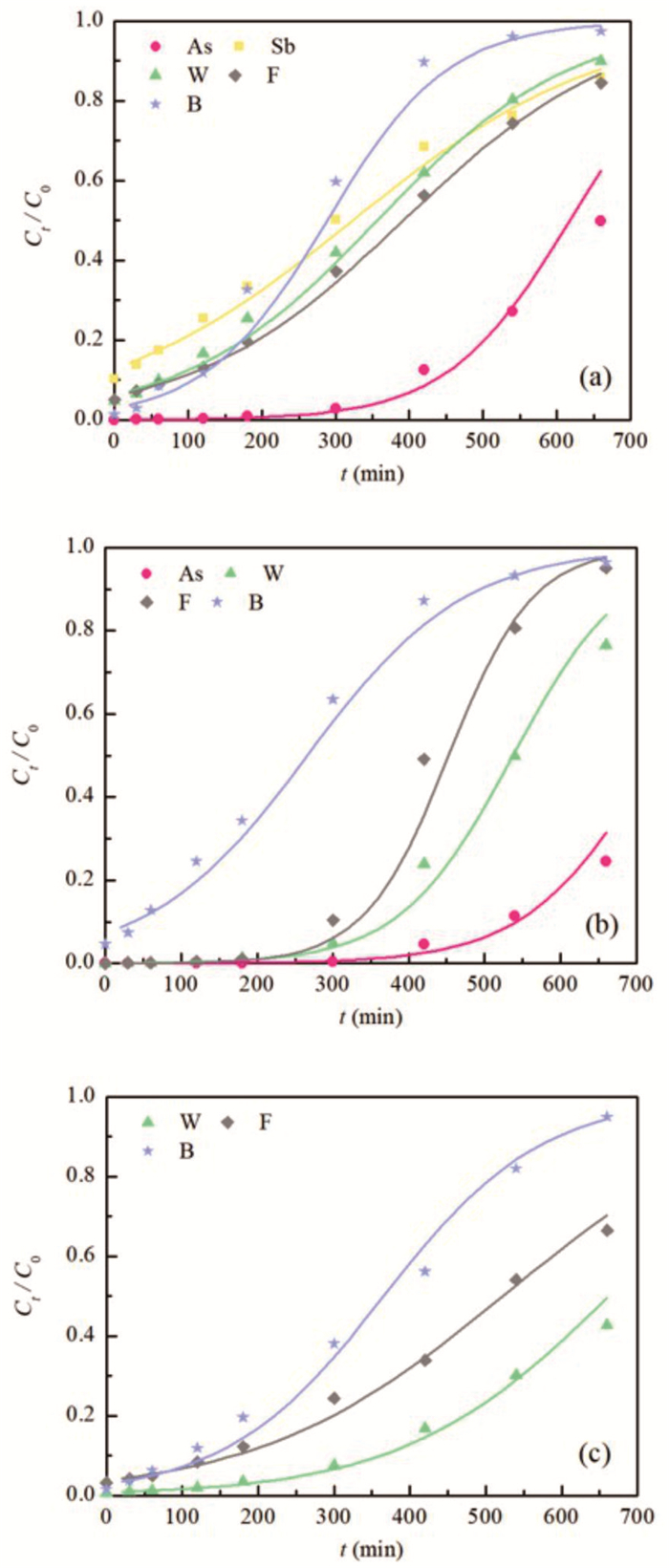
Geothermal waters are generally enriched in multiple groups of harmful components, which threaten the safety of drinking water for the surrounding residents when non-concentrated discharged in the form of hot springs. In this paper, five iron-based LDH (Fe-LDH) modified materials were prepared and used in the treatment of hot springs in typical geothermal areas of Yunnan. The results show that Fe-LDH has the best removal of arsenic, followed by fluoride and tungsten, and the removal of antimony and boron was influenced by coexisting ions; whereas, the modified materials effectively narrow the gap of competitive sorption between different harmful components, which shows that ion exchange capacity of the lactate intercalated Fe-LDH was significantly improved and the removal of fluorine and boron was enhanced, while the delaminated Fe-LDHs exposed more active sites and increased the interlayer contact, thus it had a greater enhancement on the removal of arsenic and tungsten, which are primarily complexed with iron, along with the removal of fluoride and boron by ion exchange. Finally, the best sorbent in static sorption performance, L-asparagine delaminated Fe-LDH, could dynamically and effectively remove multiple groups of harmful components from hot springs as a filling material for small water treatment devices, which provides a practical method for the remediation of geothermal waters.


2023, 48(3): 1156-1178.
doi: 10.3799/dqkx.2022.264
Abstract:
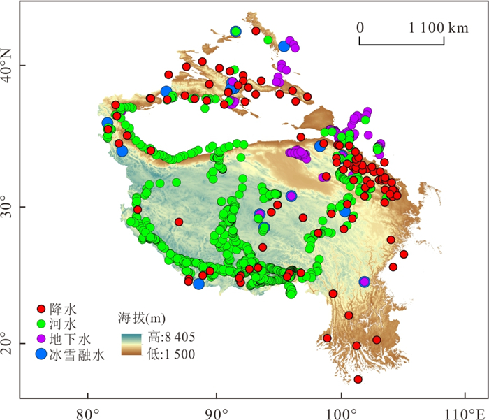
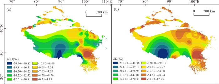
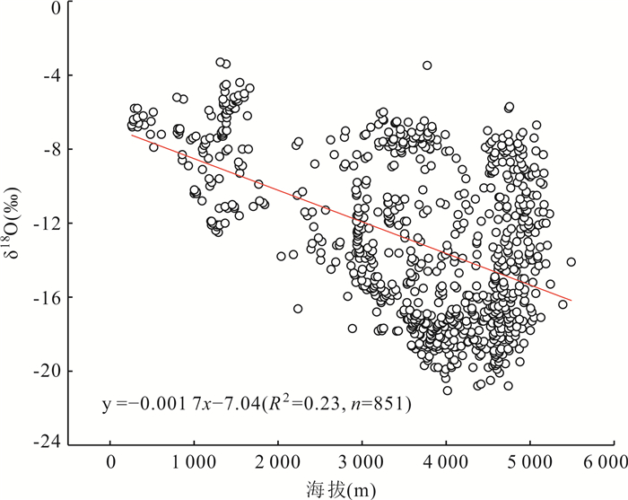
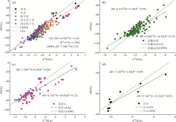
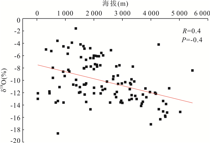
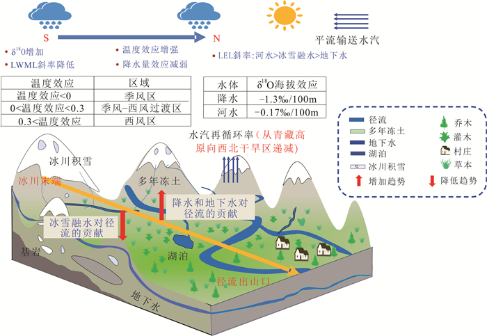
The mountainous alpine area in western China is an Asian water tower and is an important ecological barrier area. With the development of environmental isotope test technology and the maturity of the related theories, stabilizing isotope technology has become a technique integrating many functions such as tracing, integration, and indication. Based on the previous research results, this study sorts out and summarizes the isotopic ecohydrology of the alpine mountains in a western area. It is found that the atmospheric precipitation line in the west of the alpine mountains is δD=7.44δ18O+5.23 (R2=0.86). The temperature effect shows an increasing trend from the south to north, while the precipitation effect shows an opposite direction. The water vapor sources in the western alpine mountains are complex. When the temperature coefficient is less than 0, the water vapor source is dominated by the southwest monsoon; when the temperature coefficient is 0-0.3, the water vapor source is jointly dominated by the southwest monsoon and the westerly wind; when the temperature coefficient is more significant than 0.3, the water vapor source is dominated by the westerly wind. Different water bodies are affected by water supply and evaporation differences. The slope of the local evaporation lines of stable isotope in each water body is in the following order: river water > ice and snow melt water > groundwater. The altitude effect of δ18O in precipitation in the western alpine mountains is -1.3‰/100m, and the altitude effect of δ18O in river water is -0.17‰/100m. The primary source of plant water in the study area is soil water, and the utilization rate of water is closely related to plant types and the regional environment. Water vapor recycling has become an essential part of regional precipitation water vapor sources. However, with the deepening of the major national strategy of ecological civilization construction, the western alpine mountainous area, which is an essential national ecological barrier, is undergoing profound and drastic changes in the ecological and hydrological processes under the changing environment. It poses challenges to regional water resources security, ecological security and sustainable development, which in turn provides a broad stage for the development of isotope ecohydrology in cold regions. In the future, it is urgent to further advances in the four aspects involving the observation, sampling, modeling, and theory in this domain.
The mountainous alpine area in western China is an Asian water tower and is an important ecological barrier area. With the development of environmental isotope test technology and the maturity of the related theories, stabilizing isotope technology has become a technique integrating many functions such as tracing, integration, and indication. Based on the previous research results, this study sorts out and summarizes the isotopic ecohydrology of the alpine mountains in a western area. It is found that the atmospheric precipitation line in the west of the alpine mountains is δD=7.44δ18O+5.23 (R2=0.86). The temperature effect shows an increasing trend from the south to north, while the precipitation effect shows an opposite direction. The water vapor sources in the western alpine mountains are complex. When the temperature coefficient is less than 0, the water vapor source is dominated by the southwest monsoon; when the temperature coefficient is 0-0.3, the water vapor source is jointly dominated by the southwest monsoon and the westerly wind; when the temperature coefficient is more significant than 0.3, the water vapor source is dominated by the westerly wind. Different water bodies are affected by water supply and evaporation differences. The slope of the local evaporation lines of stable isotope in each water body is in the following order: river water > ice and snow melt water > groundwater. The altitude effect of δ18O in precipitation in the western alpine mountains is -1.3‰/100m, and the altitude effect of δ18O in river water is -0.17‰/100m. The primary source of plant water in the study area is soil water, and the utilization rate of water is closely related to plant types and the regional environment. Water vapor recycling has become an essential part of regional precipitation water vapor sources. However, with the deepening of the major national strategy of ecological civilization construction, the western alpine mountainous area, which is an essential national ecological barrier, is undergoing profound and drastic changes in the ecological and hydrological processes under the changing environment. It poses challenges to regional water resources security, ecological security and sustainable development, which in turn provides a broad stage for the development of isotope ecohydrology in cold regions. In the future, it is urgent to further advances in the four aspects involving the observation, sampling, modeling, and theory in this domain.


2023, 48(3): 1179-1194.
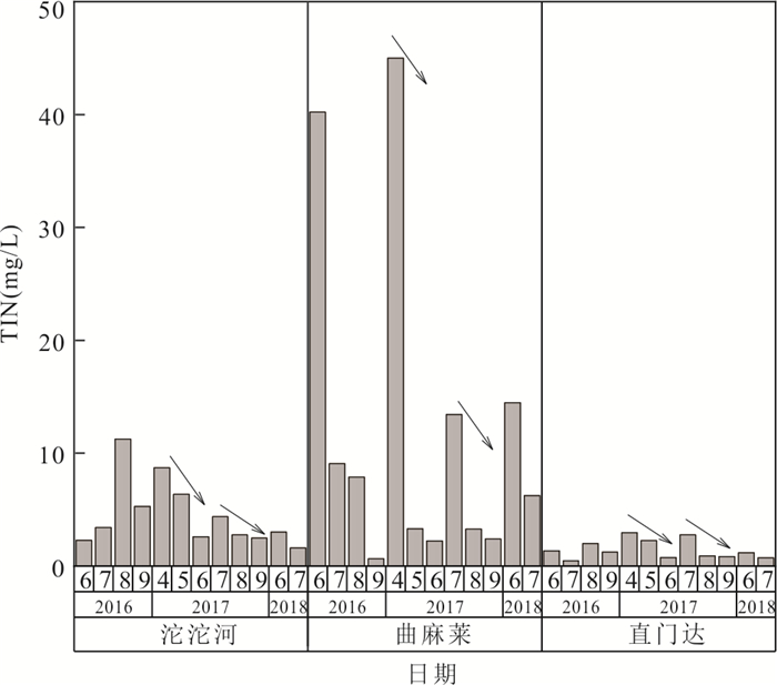
doi: 10.3799/dqkx.2022.319
Abstract:
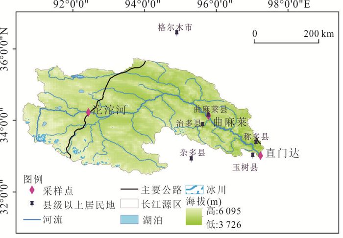
As the source of the longest river in Asia, the source region of the Yangtze River is great significance to explore its nitrogen deposition characteristics for protecting the safety of water sources in China. The result shows: (1) From April 2016 to July 2018, the average concentrations of NO2--N、NO3--N and NH4+-N were 1.01 mg/L, 2.45 mg/L and 1.30 mg/L respectively, the average deposition of NO2--N、NO3--N and NH4+-N were 0.02 kg/hm2、0.09 kg/hm2、0.30 kg/hm2. Qumalai had the highest proportion to the overall nitrogen deposition concentration in the source region of the Yangtze River, followed by the Tuotuo River, Zhimenda was the smallest, and the nitrogen deposition in spring and summer was higher than that in autumn and winter. (2) There was a logarithmic function relationship between nitrogen concentration and precipitation, and a positive power function relationship between deposition and precipitation; NO2--N and NO3--N deposition were negatively correlated with temperature, and NH4+-N was positively correlated with temperature. (3) The increase in NH4+-N deposition in the source region of the Yangtze River in summer is mainly due to grazing by herdsmen, and the increase in NOx--N deposition in winter is mainly due to coal combustion, and the transmission of pollutants is also affected by westerly circulation and local circulation, and overseas sources are more concentrated in West Asia.
As the source of the longest river in Asia, the source region of the Yangtze River is great significance to explore its nitrogen deposition characteristics for protecting the safety of water sources in China. The result shows: (1) From April 2016 to July 2018, the average concentrations of NO2--N、NO3--N and NH4+-N were 1.01 mg/L, 2.45 mg/L and 1.30 mg/L respectively, the average deposition of NO2--N、NO3--N and NH4+-N were 0.02 kg/hm2、0.09 kg/hm2、0.30 kg/hm2. Qumalai had the highest proportion to the overall nitrogen deposition concentration in the source region of the Yangtze River, followed by the Tuotuo River, Zhimenda was the smallest, and the nitrogen deposition in spring and summer was higher than that in autumn and winter. (2) There was a logarithmic function relationship between nitrogen concentration and precipitation, and a positive power function relationship between deposition and precipitation; NO2--N and NO3--N deposition were negatively correlated with temperature, and NH4+-N was positively correlated with temperature. (3) The increase in NH4+-N deposition in the source region of the Yangtze River in summer is mainly due to grazing by herdsmen, and the increase in NOx--N deposition in winter is mainly due to coal combustion, and the transmission of pollutants is also affected by westerly circulation and local circulation, and overseas sources are more concentrated in West Asia.


2023, 48(3): 1195-1204.
doi: 10.3799/dqkx.2022.238
Abstract:
The study of soil grain fractal characteristics in the desert-steppe transition zone can provide a scientific basis for regional soil quality evaluation, ecological management, and restoration. In this study, we use fractal theory to analyze the soil particle composition and fractal characteristics of three vegetation types in the desert-steppe transition zone along the northern bank of the Yellow River basin in Lanzhou. (1) The soil in the study area is mainly composed of silt and very fine sand, and as desertification degree and soil depth increase, the contents of clay and silt decrease and sand contents show the opposite trend. In addition, the frequency curve of soil particle size distribution (PSD) becomes more heterogeneous, and the homogeneity of soil texture decreases. (2) The single fractal dimension (Dv), multifractal generalized dimension spectrum parameters (D1, D1/D0, and D2), and the singular spectral function parameters (△α and △f) decrease significantly with the increase of desertification degree and soil depth. (3) Dv, D1, D2, D1/D0, △α, and △f are significantly positively correlated with clay and silt contents, and significantly negatively correlated with sand contents. The clay contents, silt contents, Dv, D1, D2, D1/D0, △α, and △f are positively correlated with the decrease of desertification degree, while the sand content is negatively correlated with it. The single weight and multiple fractal dimensions of soil can well reflect the structural properties and changes of soil in different vegetation types of the desert-steppe transition zone, which can provide theoretical basis and technical guidance for regional ecological management and consolidation.
The study of soil grain fractal characteristics in the desert-steppe transition zone can provide a scientific basis for regional soil quality evaluation, ecological management, and restoration. In this study, we use fractal theory to analyze the soil particle composition and fractal characteristics of three vegetation types in the desert-steppe transition zone along the northern bank of the Yellow River basin in Lanzhou. (1) The soil in the study area is mainly composed of silt and very fine sand, and as desertification degree and soil depth increase, the contents of clay and silt decrease and sand contents show the opposite trend. In addition, the frequency curve of soil particle size distribution (PSD) becomes more heterogeneous, and the homogeneity of soil texture decreases. (2) The single fractal dimension (Dv), multifractal generalized dimension spectrum parameters (D1, D1/D0, and D2), and the singular spectral function parameters (△α and △f) decrease significantly with the increase of desertification degree and soil depth. (3) Dv, D1, D2, D1/D0, △α, and △f are significantly positively correlated with clay and silt contents, and significantly negatively correlated with sand contents. The clay contents, silt contents, Dv, D1, D2, D1/D0, △α, and △f are positively correlated with the decrease of desertification degree, while the sand content is negatively correlated with it. The single weight and multiple fractal dimensions of soil can well reflect the structural properties and changes of soil in different vegetation types of the desert-steppe transition zone, which can provide theoretical basis and technical guidance for regional ecological management and consolidation.


2023, 48(3): 1205-1216.
doi: 10.3799/dqkx.2022.056
Abstract:
The Bainaimiao arc belt is located in the northern margin of the North China Craton. The exact time of the collision between the Bainaimiao arc belt and the North China Craton is thus a key for understanding the accretionary process of the northern margin of the North China Craton. In order to constrain the collision time of the Bainaimiao arc belt and the North China Craton, this study carried out zircon U-Pb age dating and zircon Lu-Hf isotope analysis of the Chaganhabu Formation. The weighted average age of the three youngest zircons from the Chaganhabu Formation is 393.5±4.9 Ma, consistent with previous paleontological reports. Therefore, the maximum deposition age of the Chaganhabu Formation is the late Early Devonian. Moreover, the characteristic of zircon U-Pb age spectra and Hf isotope of the Chaganhabu Formation is similar to that of the Bainaimiao arc belt and different from that of the North China Craton, which means that the provenance of the Chaganhabu Formation is the Bainaimiao arc belt rather than the North China Craton. Combined with regional tectonic research, these data indicate that during the Early Devonian, there was still a wide ocean between the Bainaimiao arc belt and the northern margin of the North China Craton, and the arc-continent collision has not yet occurred.
The Bainaimiao arc belt is located in the northern margin of the North China Craton. The exact time of the collision between the Bainaimiao arc belt and the North China Craton is thus a key for understanding the accretionary process of the northern margin of the North China Craton. In order to constrain the collision time of the Bainaimiao arc belt and the North China Craton, this study carried out zircon U-Pb age dating and zircon Lu-Hf isotope analysis of the Chaganhabu Formation. The weighted average age of the three youngest zircons from the Chaganhabu Formation is 393.5±4.9 Ma, consistent with previous paleontological reports. Therefore, the maximum deposition age of the Chaganhabu Formation is the late Early Devonian. Moreover, the characteristic of zircon U-Pb age spectra and Hf isotope of the Chaganhabu Formation is similar to that of the Bainaimiao arc belt and different from that of the North China Craton, which means that the provenance of the Chaganhabu Formation is the Bainaimiao arc belt rather than the North China Craton. Combined with regional tectonic research, these data indicate that during the Early Devonian, there was still a wide ocean between the Bainaimiao arc belt and the northern margin of the North China Craton, and the arc-continent collision has not yet occurred.
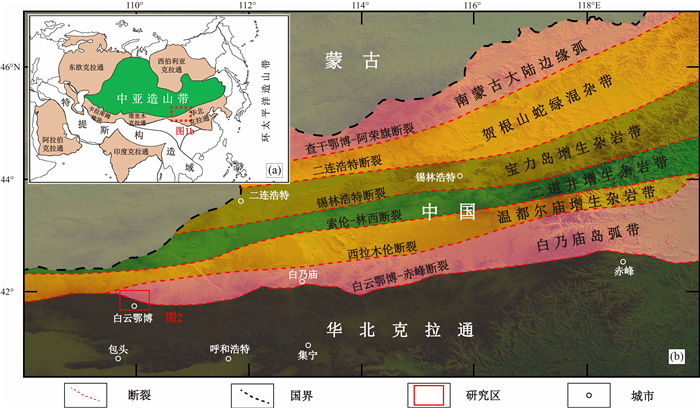
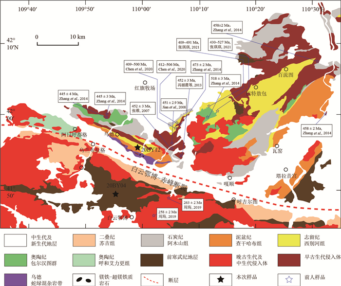

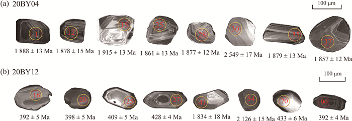


2023, 48(3): 1217-1231.
doi: 10.3799/dqkx.2022.354
Abstract:
The redox state of the lithospheric mantle can be estimated by well equilibrated mineral pairs of mantle peridotite xenoliths. Here we explore the mantle redox state of the northwest North China Craton by measuring the mineral Fe3+/∑Fe of the Langshan spinel lherzolite xenoliths using the newly established lab of WSS-10 Mössbauer spectroscopy at China University of Geosciences (Wuhan). The results show that the Fe3+/∑Fe ratios are 0.05-0.11 for orthopyroxene, 0.16-0.25 for clinopyroxene, 0.16-0.22 for spinel, and no Fe3+ was confirmed in olivine. The corresponding mantle oxygen fugacity using the olivine-orthopyroxene-spinel oxy-barometry is FMQ-0.82 to FMQ-0.39 (averaged at FMQ-0.65), slightly higher than the estimates using electron microprobe data (FMQ-1.49 to FMQ-0.8, averaged at FMQ-1.25). This discrepancy may be explained by the non-stoichiometry Fe3+ excess and cation vacancies in the spinel lattice, which is generally ignored in the stoichinometric calculation using electron microprobe data. Compared with global cratonic mantle (averaged at FMQ-0.35), the lithospheric mantle underneath the northwest North China Craton, represent by Langshan mantle xenoliths, is relatively reduced, and likely results from metasomatism by low-fO2 melts from deeper mantle domains.
The redox state of the lithospheric mantle can be estimated by well equilibrated mineral pairs of mantle peridotite xenoliths. Here we explore the mantle redox state of the northwest North China Craton by measuring the mineral Fe3+/∑Fe of the Langshan spinel lherzolite xenoliths using the newly established lab of WSS-10 Mössbauer spectroscopy at China University of Geosciences (Wuhan). The results show that the Fe3+/∑Fe ratios are 0.05-0.11 for orthopyroxene, 0.16-0.25 for clinopyroxene, 0.16-0.22 for spinel, and no Fe3+ was confirmed in olivine. The corresponding mantle oxygen fugacity using the olivine-orthopyroxene-spinel oxy-barometry is FMQ-0.82 to FMQ-0.39 (averaged at FMQ-0.65), slightly higher than the estimates using electron microprobe data (FMQ-1.49 to FMQ-0.8, averaged at FMQ-1.25). This discrepancy may be explained by the non-stoichiometry Fe3+ excess and cation vacancies in the spinel lattice, which is generally ignored in the stoichinometric calculation using electron microprobe data. Compared with global cratonic mantle (averaged at FMQ-0.35), the lithospheric mantle underneath the northwest North China Craton, represent by Langshan mantle xenoliths, is relatively reduced, and likely results from metasomatism by low-fO2 melts from deeper mantle domains.

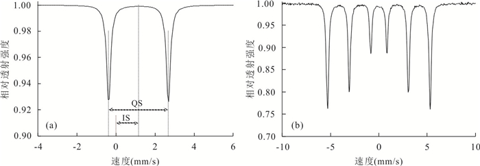


2023, 48(3): 1232-1245.
doi: 10.3799/dqkx.2022.388
Abstract:
Although, the paleoclimate plays an important role in controlling uranium mineralization during the deposition of uranium-bearing rocks, it has not attracted enough attention of uranium geologists for a long time. The lower member of Yaojia formation is the ore bearing target layer in the southwest of Songliao basin. Taking the lower member of Yaojia formation as the research object, the contents of the main and trace elements and total organic carbon of mudstone samples from representative boreholes were tested. A number of chemical weathering indexes, such as K/Na ratio, aAlNa, chemical proxy of alteration (CPA), modified chemical index of alteration (CIX), plagioclase index of alteration (PIA), chemical index of weathering (CIW), chemical index of alteration (CIA), are used to judge the intensity of chemical weathering of the samples, and reconstruct the paleoclimate conditions during the depositional period. At the same time, combined with the contents of U and TOC and the ratio of Fe2+/Fe3+, the constraints of paleoclimate conditions on uranium mineralization during the deposition of uranium-bearing rock series in the study area are discussed. The results show that the clastic rocks in the study area have experienced the change of chemical weathering intensity from weak to strong to weak, indicating that the evolution law of paleoclimate from relative cold and drought to relative warm and humidity to relative cold and drought. This paleoclimate change leads to low TOC content in uranium reservoir sand bodies (average value 0.05%) and large-scale development of interlayer oxidation zone, so uranium ore bodies are mainly located in the hinterland of the basin far away from the erosion source area. Dark mudstone formed in humid climate has higher TOC (average 0.61%) and U content (up to 885×10-6). It has become one of the important sources of uranium due to its strong preconcentration during deposition. The discharge of reducing pore water during diagenesis may be the main factor for the construction of oxidation-reduction barrier in uranium reservoir sand bodies. During deposition, the warm and humid climate enhances the intensity of chemical weathering in the source area, which is conducive to the activation and leaching of uranium in the parent rock and the uranium preconcentration of mudstone in the sedimentary area.
Although, the paleoclimate plays an important role in controlling uranium mineralization during the deposition of uranium-bearing rocks, it has not attracted enough attention of uranium geologists for a long time. The lower member of Yaojia formation is the ore bearing target layer in the southwest of Songliao basin. Taking the lower member of Yaojia formation as the research object, the contents of the main and trace elements and total organic carbon of mudstone samples from representative boreholes were tested. A number of chemical weathering indexes, such as K/Na ratio, aAlNa, chemical proxy of alteration (CPA), modified chemical index of alteration (CIX), plagioclase index of alteration (PIA), chemical index of weathering (CIW), chemical index of alteration (CIA), are used to judge the intensity of chemical weathering of the samples, and reconstruct the paleoclimate conditions during the depositional period. At the same time, combined with the contents of U and TOC and the ratio of Fe2+/Fe3+, the constraints of paleoclimate conditions on uranium mineralization during the deposition of uranium-bearing rock series in the study area are discussed. The results show that the clastic rocks in the study area have experienced the change of chemical weathering intensity from weak to strong to weak, indicating that the evolution law of paleoclimate from relative cold and drought to relative warm and humidity to relative cold and drought. This paleoclimate change leads to low TOC content in uranium reservoir sand bodies (average value 0.05%) and large-scale development of interlayer oxidation zone, so uranium ore bodies are mainly located in the hinterland of the basin far away from the erosion source area. Dark mudstone formed in humid climate has higher TOC (average 0.61%) and U content (up to 885×10-6). It has become one of the important sources of uranium due to its strong preconcentration during deposition. The discharge of reducing pore water during diagenesis may be the main factor for the construction of oxidation-reduction barrier in uranium reservoir sand bodies. During deposition, the warm and humid climate enhances the intensity of chemical weathering in the source area, which is conducive to the activation and leaching of uranium in the parent rock and the uranium preconcentration of mudstone in the sedimentary area.

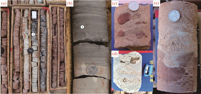

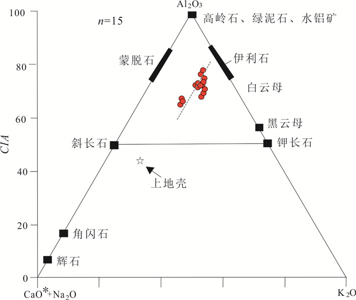


2023, 48(3): 1246-1258.
doi: 10.3799/dqkx.2022.389
Abstract:
With the large-scale development of coalbed methane industry, the environmental effects of produced water from coalbed methane wells receive more attention. Taking 8 coalbed methane test wells in Songhejing Formation in western Guizhou as an example, the geochemical data of 5 batches of produced water in 2018 were tracked dynamically, and the environmental effects of produced water were evaluated by fuzzy comprehensive evaluation method and single factor analysis method, and the causes were analyzed. The following conclusions were drawn: The geochemical characteristics of coalbed methane produced water in Songhejing Formation are mainly characterized by high concentration of Na+, HCO3‒ and Cl‒ and high salinity, and the produced water types are Na-Cl and Na-HCO3‒. In this paper, the fuzzy comprehensive evaluation method is used to calculate that the produced water of eight coalbed methane test wells belongs to grade V heavy pollution, and the main pollution indicators are TDS, Na+ and Cl‒, and the elements F and Mn slightly exceed the standard. On this basis, the single factor analysis shows that the evaluation result is heavy pollution. Two comprehensive evaluation methods show that the main pollution indicators are TDS, Na+, Cl‒ and Ba2+. In a certain range, the pollution degree fluctuates slightly with time and has a weak decreasing trend. The water pollution level of coalbed methane wells in the study area is high and fluctuates with time, which is the coupling result of the superposition of geological factors and engineering factors. The high geological background of various elements enrichment in coal measures strata is the fundamental influencing factor, which controls the types and contents of trace elements. Secondly, the change of fracturing fluid flowback rate has a significant effect. Seasonal precipitation strengthens the water-rock effect and promotes the dissolution of elements.
With the large-scale development of coalbed methane industry, the environmental effects of produced water from coalbed methane wells receive more attention. Taking 8 coalbed methane test wells in Songhejing Formation in western Guizhou as an example, the geochemical data of 5 batches of produced water in 2018 were tracked dynamically, and the environmental effects of produced water were evaluated by fuzzy comprehensive evaluation method and single factor analysis method, and the causes were analyzed. The following conclusions were drawn: The geochemical characteristics of coalbed methane produced water in Songhejing Formation are mainly characterized by high concentration of Na+, HCO3‒ and Cl‒ and high salinity, and the produced water types are Na-Cl and Na-HCO3‒. In this paper, the fuzzy comprehensive evaluation method is used to calculate that the produced water of eight coalbed methane test wells belongs to grade V heavy pollution, and the main pollution indicators are TDS, Na+ and Cl‒, and the elements F and Mn slightly exceed the standard. On this basis, the single factor analysis shows that the evaluation result is heavy pollution. Two comprehensive evaluation methods show that the main pollution indicators are TDS, Na+, Cl‒ and Ba2+. In a certain range, the pollution degree fluctuates slightly with time and has a weak decreasing trend. The water pollution level of coalbed methane wells in the study area is high and fluctuates with time, which is the coupling result of the superposition of geological factors and engineering factors. The high geological background of various elements enrichment in coal measures strata is the fundamental influencing factor, which controls the types and contents of trace elements. Secondly, the change of fracturing fluid flowback rate has a significant effect. Seasonal precipitation strengthens the water-rock effect and promotes the dissolution of elements.