2023 Vol. 48, No. 4
Display Method:
2023, 48(4): 1259-1270.
doi: 10.3799/dqkx.2022.400
 PDF 4422KB
Abstract:
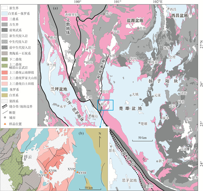
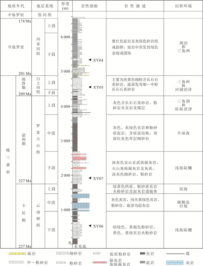
There exist divergent views about the Indosinian tectonic nature of basin and the evolution of basin-range pattern in the southwest margin of the Yangtze block. Detrital zircon U-Pb dating and detrital provenance analysis of sandstone samples from the Upper Triassic-Lower Jurassic of Xiangyun Section in the western Chuxiong basin were carried out. The results show that the detrital sources of the Upper Triassic Yunnanyi Formation and Luojiadashan Formation are mainly from the Middle-Lower Triassic and Permian in the Upper Yangtze region. The detrital sources of the Upper Triassic Baitutian Formation and the Lower Jurassic Fengjiahe Formation are mainly from the Songpan-Ganzi terrane and Kangdian ancient land.Combined with the sedimentary environment evolution and regional geological setting, it is considered that the orogeny is relatively weak during the earlier Late Triassic, and Chuxiong basin is an underfilled basin, whose clastic source supply is insufficient. From the later Late Triassic to Early Jurassic, the tectonic evolution of Chuxiong basin was controlled by the thrust nappe of Ailaoshan orogenic belt, but the sedimentary filling process of Chuxiong basin was mainly controlled by the rapid rise of Songpan-Ganzi orogenic belt.
There exist divergent views about the Indosinian tectonic nature of basin and the evolution of basin-range pattern in the southwest margin of the Yangtze block. Detrital zircon U-Pb dating and detrital provenance analysis of sandstone samples from the Upper Triassic-Lower Jurassic of Xiangyun Section in the western Chuxiong basin were carried out. The results show that the detrital sources of the Upper Triassic Yunnanyi Formation and Luojiadashan Formation are mainly from the Middle-Lower Triassic and Permian in the Upper Yangtze region. The detrital sources of the Upper Triassic Baitutian Formation and the Lower Jurassic Fengjiahe Formation are mainly from the Songpan-Ganzi terrane and Kangdian ancient land.Combined with the sedimentary environment evolution and regional geological setting, it is considered that the orogeny is relatively weak during the earlier Late Triassic, and Chuxiong basin is an underfilled basin, whose clastic source supply is insufficient. From the later Late Triassic to Early Jurassic, the tectonic evolution of Chuxiong basin was controlled by the thrust nappe of Ailaoshan orogenic belt, but the sedimentary filling process of Chuxiong basin was mainly controlled by the rapid rise of Songpan-Ganzi orogenic belt.


2023, 48(4): 1271-1287.
doi: 10.3799/dqkx.2022.312
Abstract:
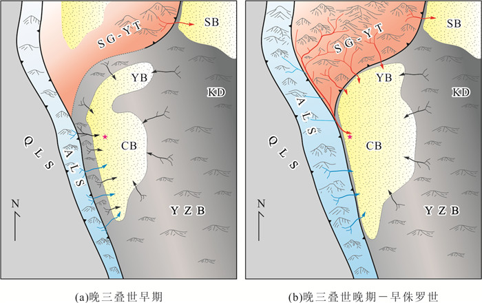
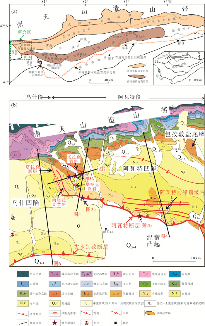
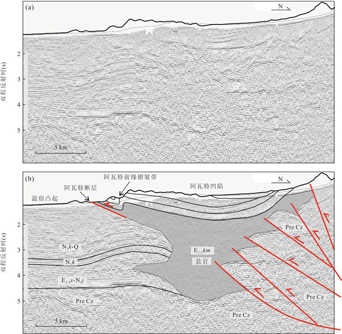
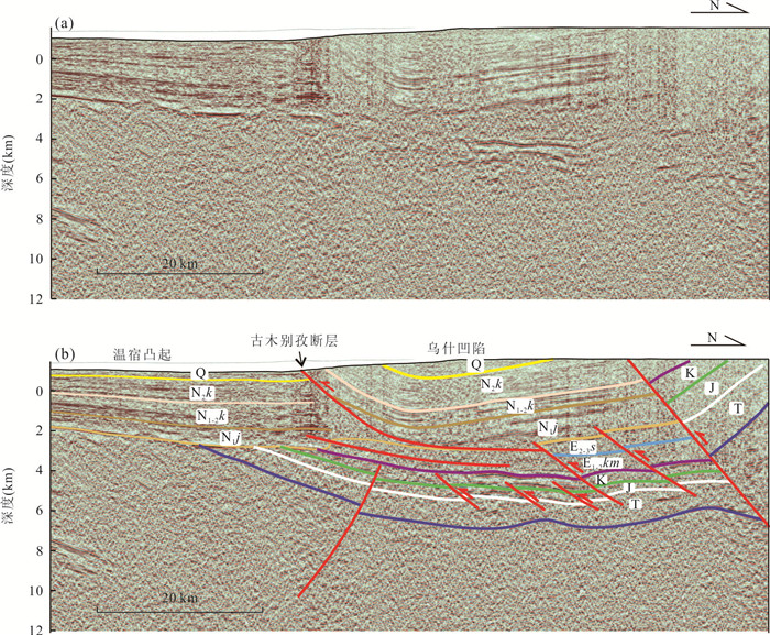
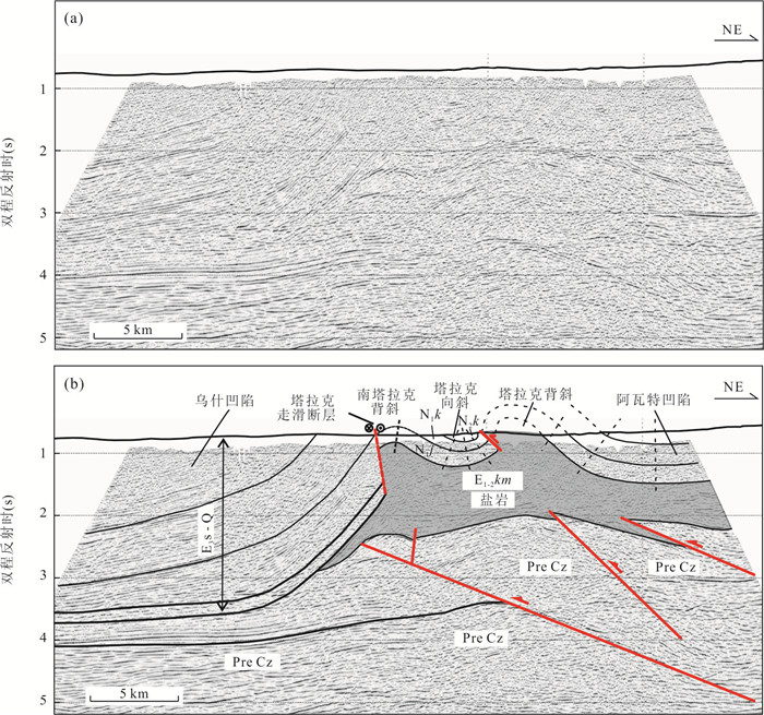
In order to determine the characteristics and influencing factors of salt structure evolution located at the border of salt basin in western Kuqa depression, a comprehensive analysis of Awate transfer zone was carried out by field geological survey, structural analysis of industrial seismic profiles and 3D sand-box analogue modeling experiment. The results show follows. (1)Awate structural belt is a typical compressional structural transfer zone in western Kuqa depression, where differential structures formed from imbricated thrust faults in the Wushi sag to salt-related folds in the Awate sag. (2) The Talake strike-slip fault occurred at the junction of Wushi sag and Awate sag is an accommodative transverse fault developed in the overburden. Influenced by this fault, Talake syncline, Talake anticline and other drag salt-related structures formed in the overburden. The closer to the Talake strike-slip fault, the stronger the drag and wrinkling effect becomes, and even the fold-related faults are easy to develop, prompting the outcrop of salt rock in the core of anticline. (3) The Cenozoic deformation of Awate structural transfer zone is mainly controlled by regional compression, the distribution of salt rock and the activity of basement faults.
In order to determine the characteristics and influencing factors of salt structure evolution located at the border of salt basin in western Kuqa depression, a comprehensive analysis of Awate transfer zone was carried out by field geological survey, structural analysis of industrial seismic profiles and 3D sand-box analogue modeling experiment. The results show follows. (1)Awate structural belt is a typical compressional structural transfer zone in western Kuqa depression, where differential structures formed from imbricated thrust faults in the Wushi sag to salt-related folds in the Awate sag. (2) The Talake strike-slip fault occurred at the junction of Wushi sag and Awate sag is an accommodative transverse fault developed in the overburden. Influenced by this fault, Talake syncline, Talake anticline and other drag salt-related structures formed in the overburden. The closer to the Talake strike-slip fault, the stronger the drag and wrinkling effect becomes, and even the fold-related faults are easy to develop, prompting the outcrop of salt rock in the core of anticline. (3) The Cenozoic deformation of Awate structural transfer zone is mainly controlled by regional compression, the distribution of salt rock and the activity of basement faults.


2023, 48(4): 1288-1306.
doi: 10.3799/dqkx.2022.071
Abstract:
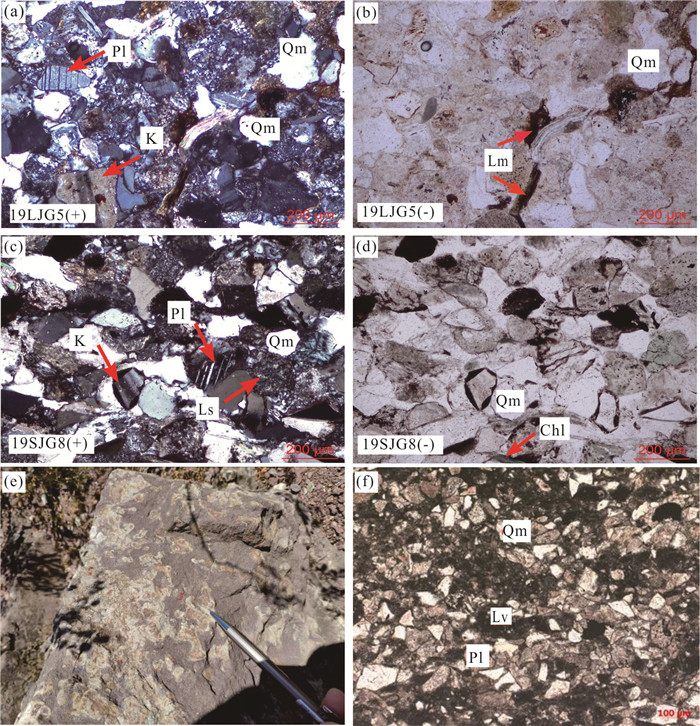
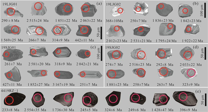
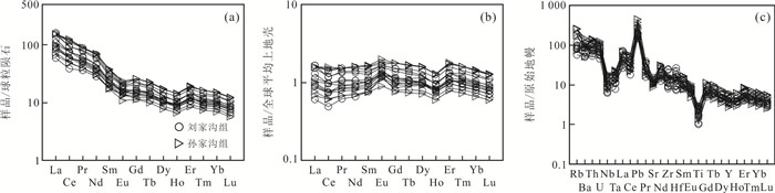
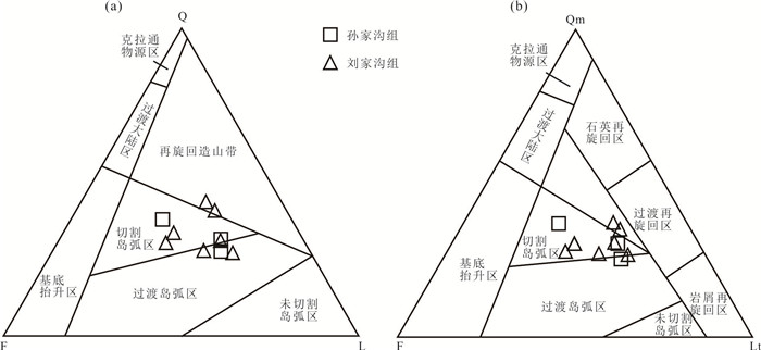
The Permian-Triassic stratum of North China craton is well known for its extensive distribution, special lithology, marine-terrestrial transition system and significant division of sedimentary lithology. The predecessors have discussed sedimentary age and source of the Permian-Triassic sandstones, but there is still much controversy. In this study, five sandstone samples are selected from the eastern Ordos basin (Liulin area, Liujiagou and Sunjiagou formations) and Qinshui basin (Qinshui area, Sunjiagou Formation) in Shanxi Province of the central North China craton for LA-ICP-MS U-Pb dating of detrital zircons and geochemical analysis, with the attempt to determine the maximum sedimentary age and its provenance. The geochronology results show that detrital zircons (n=364) from five samples are composed mainly of the Paleozoic and Precambrian magmatic zircons. Among them, the Paleozoic zircons account for 21% with peak ages of ~275 Ma (218-333 Ma; n=65) and ~431 Ma (368-442 Ma; n=10), while the Precambrian zircons account for 79% with distinct peak ages of ~1 888 Ma (1 562-2 222 Ma; n=178) and ~2 529 Ma (2 253-3 167 Ma; n=111). By using the youngest single detrital zircons ages (YSG) and TuffZirc (Zircon Age Extractor)(+6), it obtained different maximum sedimentary ages of 253±7 Ma and 250±7 Ma for the Liujiagou Formation, as well as 256±7 Ma (MSWD=1.1, n=31), 264±11 Ma (MSWD=4.3, n=7), and 250±6 Ma (MSWD=3.6, n=6) for the Sunjiagou Formation, respectively, which is close to the Permian/Triassic boundary age 251.0±0.4 Ma. Based on these results, it constrains that the Liujiagou Formation formed in the Early Triassic and Sunjiagou Formation formed in the Late Permian, and further presume that the sedimentary timing of northern part of Sunjiagou Formation in Shanxi Province is older than southern part. The main material sources of the Permian-Triassic sandstones (Liujiagou and Sunjiagou Formations) are from the Late Paleozoic intrusive rocks in the Inner Mongolia uplift at the northern part of North China craton and the metamorphic basement of North China craton, while a few material sources are from granitic intrusive rocks in southern Xing-Meng orogenic belt.
The Permian-Triassic stratum of North China craton is well known for its extensive distribution, special lithology, marine-terrestrial transition system and significant division of sedimentary lithology. The predecessors have discussed sedimentary age and source of the Permian-Triassic sandstones, but there is still much controversy. In this study, five sandstone samples are selected from the eastern Ordos basin (Liulin area, Liujiagou and Sunjiagou formations) and Qinshui basin (Qinshui area, Sunjiagou Formation) in Shanxi Province of the central North China craton for LA-ICP-MS U-Pb dating of detrital zircons and geochemical analysis, with the attempt to determine the maximum sedimentary age and its provenance. The geochronology results show that detrital zircons (n=364) from five samples are composed mainly of the Paleozoic and Precambrian magmatic zircons. Among them, the Paleozoic zircons account for 21% with peak ages of ~275 Ma (218-333 Ma; n=65) and ~431 Ma (368-442 Ma; n=10), while the Precambrian zircons account for 79% with distinct peak ages of ~1 888 Ma (1 562-2 222 Ma; n=178) and ~2 529 Ma (2 253-3 167 Ma; n=111). By using the youngest single detrital zircons ages (YSG) and TuffZirc (Zircon Age Extractor)(+6), it obtained different maximum sedimentary ages of 253±7 Ma and 250±7 Ma for the Liujiagou Formation, as well as 256±7 Ma (MSWD=1.1, n=31), 264±11 Ma (MSWD=4.3, n=7), and 250±6 Ma (MSWD=3.6, n=6) for the Sunjiagou Formation, respectively, which is close to the Permian/Triassic boundary age 251.0±0.4 Ma. Based on these results, it constrains that the Liujiagou Formation formed in the Early Triassic and Sunjiagou Formation formed in the Late Permian, and further presume that the sedimentary timing of northern part of Sunjiagou Formation in Shanxi Province is older than southern part. The main material sources of the Permian-Triassic sandstones (Liujiagou and Sunjiagou Formations) are from the Late Paleozoic intrusive rocks in the Inner Mongolia uplift at the northern part of North China craton and the metamorphic basement of North China craton, while a few material sources are from granitic intrusive rocks in southern Xing-Meng orogenic belt.


2023, 48(4): 1307-1320.
doi: 10.3799/dqkx.2022.423
Abstract:
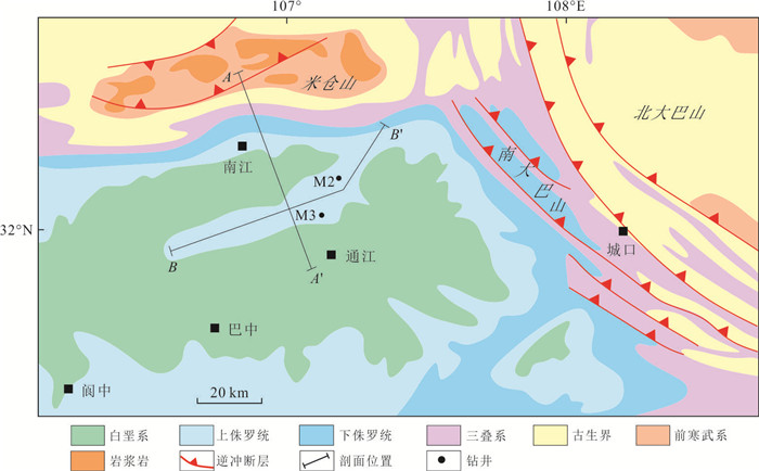
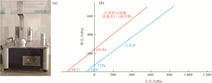
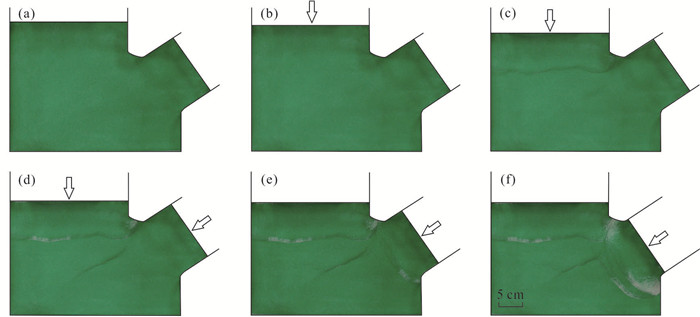
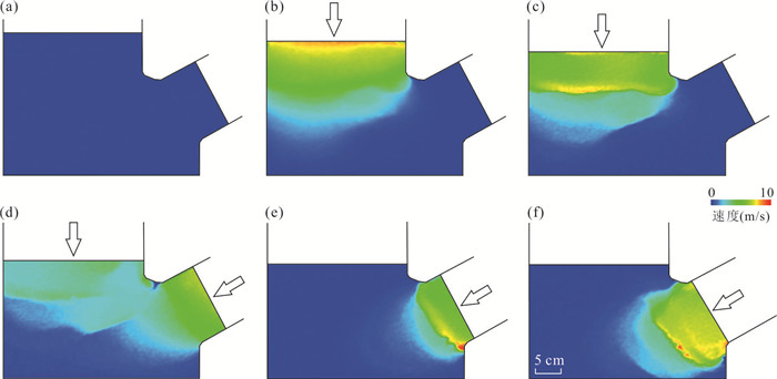
Tongnanba anticline is located in the Northeast Sichuan basin, which is adjacent to the Micangshan Mountain to the north and Dabashan Mountain to the northeast. Conducting analogue modeling on tectonic relationships between Tongnanba anticline with surrounding mountains and paleo-uplift has important significance for constraining orogenic tectonic deformation time and sequences in the region, and also has importance significance for oil and gas exploration. In the model, shortening from north and northeast represents Micangshan Mountain and Dabashan Mountain, respectively. Lower silicone and upper sand are used to represent salts of Leikoupo Formation in Triassic and upper clastic rocks, respectively. The plasticene in the model acts as uplift developed in Paleozoic in NE Sichuan basin, which is widely accepted.Experiment results show that during compression from north moving wall, velocity vectors rapidly transferred to plasticene, which representing paleo-uplift, to form NE fold and thrust. During compression from northeast moving wall, NW trend arc-shape structures were formed imposing on the earlier formed NE trend structure. Combining with earlier reports on evolution histories, it makes conclusions that the evolution of Tongnanba anticline was controlled by surrounding Micang and Daba orogenic belts to form tectonic superposition of earlier NE trend structures and later NW trend structures. While, the Paleozoic NE trend uplift in NE Sichuan basin also controlled the orientation of Tongnanba anticline.
Tongnanba anticline is located in the Northeast Sichuan basin, which is adjacent to the Micangshan Mountain to the north and Dabashan Mountain to the northeast. Conducting analogue modeling on tectonic relationships between Tongnanba anticline with surrounding mountains and paleo-uplift has important significance for constraining orogenic tectonic deformation time and sequences in the region, and also has importance significance for oil and gas exploration. In the model, shortening from north and northeast represents Micangshan Mountain and Dabashan Mountain, respectively. Lower silicone and upper sand are used to represent salts of Leikoupo Formation in Triassic and upper clastic rocks, respectively. The plasticene in the model acts as uplift developed in Paleozoic in NE Sichuan basin, which is widely accepted.Experiment results show that during compression from north moving wall, velocity vectors rapidly transferred to plasticene, which representing paleo-uplift, to form NE fold and thrust. During compression from northeast moving wall, NW trend arc-shape structures were formed imposing on the earlier formed NE trend structure. Combining with earlier reports on evolution histories, it makes conclusions that the evolution of Tongnanba anticline was controlled by surrounding Micang and Daba orogenic belts to form tectonic superposition of earlier NE trend structures and later NW trend structures. While, the Paleozoic NE trend uplift in NE Sichuan basin also controlled the orientation of Tongnanba anticline.


2023, 48(4): 1321-1329.
doi: 10.3799/dqkx.2022.394
Abstract:
The plate configuration is the basic geological question in the tectonics, which considers the large scale basin-orogen relationship, and controls the configuration of oceans and continents, origin and evolution of basin-range provinces, and has also been applied to uncover the close of ocean and uplift of mountains. The end of Early Paleozoic is the key transition period of Chinese three plates. Based on the global high coefficient paleomagnetic data and tectonic comparison in geological affiliation, the global configuration in the Late Precambrian to Early Paleozoic is reconstructed by GPlate software, the Ordovician-Silurian is the key transition period of Chinese three plates. Before 440 Ma, the configuration of Chinese three plates is N-S/T style(North China lies in the west, South China lies in the northeast, Tarim lies in the southeast). After 440 Ma, the configuration is transformed into a T-N/S style (Tarim lies in the west, North China lies in the northeast, South China lies in the southeast) that maintains. The key transition is related to the breakup of the Late Precambrian Rodinian supercontinent and the change of ocean-continent configuration of Chinese three plates in the Early Paleozoic, the transition is from extension to compression in tectonic setting.
The plate configuration is the basic geological question in the tectonics, which considers the large scale basin-orogen relationship, and controls the configuration of oceans and continents, origin and evolution of basin-range provinces, and has also been applied to uncover the close of ocean and uplift of mountains. The end of Early Paleozoic is the key transition period of Chinese three plates. Based on the global high coefficient paleomagnetic data and tectonic comparison in geological affiliation, the global configuration in the Late Precambrian to Early Paleozoic is reconstructed by GPlate software, the Ordovician-Silurian is the key transition period of Chinese three plates. Before 440 Ma, the configuration of Chinese three plates is N-S/T style(North China lies in the west, South China lies in the northeast, Tarim lies in the southeast). After 440 Ma, the configuration is transformed into a T-N/S style (Tarim lies in the west, North China lies in the northeast, South China lies in the southeast) that maintains. The key transition is related to the breakup of the Late Precambrian Rodinian supercontinent and the change of ocean-continent configuration of Chinese three plates in the Early Paleozoic, the transition is from extension to compression in tectonic setting.


2023, 48(4): 1330-1350.
doi: 10.3799/dqkx.2022.466
Abstract:
Studies on granites in the North Lancang River suture were mainly focused on the Indosinian period, but little on the Cretaceous. Based on the field geological survey, the petrogeochemistry, zircon U-Pb dating and Hf isotope of the newly discovered granites in Leiwuqi area, East Tibet are carried out. The results show that the diagenetic ages of the two granites are 75.06±0.82 Ma (MSWD=1.90) and 74.89±0.65 Ma (MSWD=1.05), respectively, which are the products of Late Cretaceous magmatic activity. The granites contain muscovite (~5%) and are characterized by high SiO2 (69.07%-69.39%), rich K2O (5.31%-5.77%) and low Mg# (0.30-0.33), with A/CNK ratio of 1.11-1.15, and are enriched in large ion lithophile elements (LILE, e.g., Rb, Th, U and Pb) and LREE, depleted in high field strength elements (HFSE, e.g., Ba, Nb, Sr, P and Ti) and HREE, with strong fractionation of light and heavy rare earth elements and significant negative Eu anomaly. These features suggest that the granites belong to the peraluminaceous S-type granite, and the source rocks are metamorphic argillaceous rocks and greywacke. The zircon εHf(t) value of the granite (-4.6 to 1.1) varies widely and are of ancient two-stage Hf isotopic model ages (TDM2, 1.07-1.43 Ga). Comprehensive analysis shows that the Late Cretaceous granites in the North Lancang River suture were generated by a degree of separation crystallization of parent magma, derived from mantle derived mafic magma formed by the upwelling and decompression melting of asthenosphere materials caused by the delamination of the thickened lithosphere, underplating into the ancient crust, inducing the melting of the ancient crust and mixing with it, which indicates that the orogenic evolution of the Leiwuqi area in East Tibet was in the late orogenic destruction stage during Late Cretaceous.
Studies on granites in the North Lancang River suture were mainly focused on the Indosinian period, but little on the Cretaceous. Based on the field geological survey, the petrogeochemistry, zircon U-Pb dating and Hf isotope of the newly discovered granites in Leiwuqi area, East Tibet are carried out. The results show that the diagenetic ages of the two granites are 75.06±0.82 Ma (MSWD=1.90) and 74.89±0.65 Ma (MSWD=1.05), respectively, which are the products of Late Cretaceous magmatic activity. The granites contain muscovite (~5%) and are characterized by high SiO2 (69.07%-69.39%), rich K2O (5.31%-5.77%) and low Mg# (0.30-0.33), with A/CNK ratio of 1.11-1.15, and are enriched in large ion lithophile elements (LILE, e.g., Rb, Th, U and Pb) and LREE, depleted in high field strength elements (HFSE, e.g., Ba, Nb, Sr, P and Ti) and HREE, with strong fractionation of light and heavy rare earth elements and significant negative Eu anomaly. These features suggest that the granites belong to the peraluminaceous S-type granite, and the source rocks are metamorphic argillaceous rocks and greywacke. The zircon εHf(t) value of the granite (-4.6 to 1.1) varies widely and are of ancient two-stage Hf isotopic model ages (TDM2, 1.07-1.43 Ga). Comprehensive analysis shows that the Late Cretaceous granites in the North Lancang River suture were generated by a degree of separation crystallization of parent magma, derived from mantle derived mafic magma formed by the upwelling and decompression melting of asthenosphere materials caused by the delamination of the thickened lithosphere, underplating into the ancient crust, inducing the melting of the ancient crust and mixing with it, which indicates that the orogenic evolution of the Leiwuqi area in East Tibet was in the late orogenic destruction stage during Late Cretaceous.


2023, 48(4): 1351-1365.
doi: 10.3799/dqkx.2022.434
Abstract:
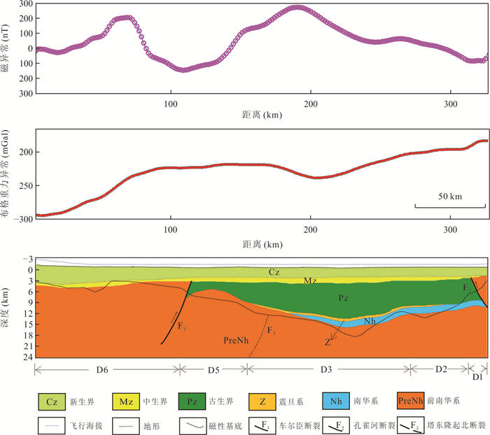
In order to explore the depth and properties of magnetic basement in northeastern Tarim basin and its indication for tectonic attributes, based on the latest high-precision aeromagnetic data, the minimum buried depth of magnetic body in northeastern Tarim basin was calculated by using section tangent method, and the magnetic basement depth map was drawn. The results show that the depth of magnetic basement in most areas of northeastern Tarim basin is approximate to the depth of bottom boundary of sedimentary cover in seismic exploration, indicating that the calculation results of tangent method have high reliability. However, in the northern edge of Tadong uplift, the magnetic basement fluctuates greatly, and the depth is obviously different from that of sedimentary cover layer. Based on the analysis of the magnetic basement depth map, combining the high-precision Bouguer gravity anomaly and seismic interpretation profile, the tectonic attributes of the Tadong uplift and Kongquehe slope are interpreted. The obviously long-wave magnetic anomaly gradient zone, the low gravity, the highly variable magnetic basement depth, combining a large number of the Paleoproterozoic metamorphic granite samples in borehole, indicate that Tadong uplift may be the most important Precambrian structural boundary. The gravity and magnetic anomalies in Kongquehe slope show obviously negative correlation. Based on the spatial structure relations of magnetic basement, the Nanhua-Sinian sedimentary thickness and gravity-magnetic anomalies, and the magnetic characteristics of the rock, etc., in this study it suggests that the Neoproterozoic rift event may reduce the magnetism of the basement, on the contrary, the crust of the central and southern region of northern depression which was not affected by the rifting, still retains the strong magnetic characteristics.
In order to explore the depth and properties of magnetic basement in northeastern Tarim basin and its indication for tectonic attributes, based on the latest high-precision aeromagnetic data, the minimum buried depth of magnetic body in northeastern Tarim basin was calculated by using section tangent method, and the magnetic basement depth map was drawn. The results show that the depth of magnetic basement in most areas of northeastern Tarim basin is approximate to the depth of bottom boundary of sedimentary cover in seismic exploration, indicating that the calculation results of tangent method have high reliability. However, in the northern edge of Tadong uplift, the magnetic basement fluctuates greatly, and the depth is obviously different from that of sedimentary cover layer. Based on the analysis of the magnetic basement depth map, combining the high-precision Bouguer gravity anomaly and seismic interpretation profile, the tectonic attributes of the Tadong uplift and Kongquehe slope are interpreted. The obviously long-wave magnetic anomaly gradient zone, the low gravity, the highly variable magnetic basement depth, combining a large number of the Paleoproterozoic metamorphic granite samples in borehole, indicate that Tadong uplift may be the most important Precambrian structural boundary. The gravity and magnetic anomalies in Kongquehe slope show obviously negative correlation. Based on the spatial structure relations of magnetic basement, the Nanhua-Sinian sedimentary thickness and gravity-magnetic anomalies, and the magnetic characteristics of the rock, etc., in this study it suggests that the Neoproterozoic rift event may reduce the magnetism of the basement, on the contrary, the crust of the central and southern region of northern depression which was not affected by the rifting, still retains the strong magnetic characteristics.


2023, 48(4): 1366-1378.
doi: 10.3799/dqkx.2022.228
Abstract:
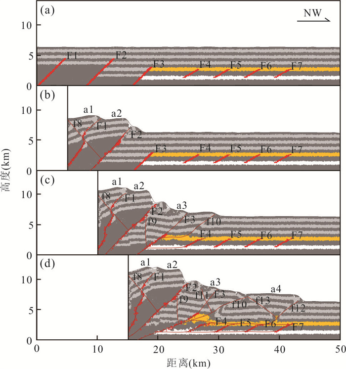
The fold-thrust belt of the northern Bogda Mountain is characterized by horizontal segmentation, vertical stratification, overlap of multi-phase structure deformation and rich pre-existing structures. Two décollements, the Xishangyao Formation of Upper Jurassic and the Badaowan Formation of Lower Jurassic, are developed in this area. In order to investigate the influence of the difference in cohesion strength between the two décollements and the pre-existing structures on the structure deformation in Cenozoic, this study designed five experiments including a model without décollement and four double-décollement models with different cohesion strength combinations adopted the discrete element method, on the basis of laying out pre-existing structures. The experimental results show that when the cohesion strengths of the double-décollement are the same, the upper décollement has the advantage in stress propagation; when the cohesion strengths of the double-décollement are different, the stress will preferentially transmits along the weaker cohesion décollement, and when the cohesion strength of the lower décollement is weaker, the upper décollement may not play a role. By comparing the experimental results with actual geological profile, it is concluded that the pre-existing structures control the structure deformation style of the thrust belt. However, the two décollements jointly control the tectonic decoupling in the vertical of the fold-thrust belt, and that the cohesion strength of the upper décollement weaker than that of the lower décollement, which is a key factor affecting the Cenozoic structure deformation in the study area.
The fold-thrust belt of the northern Bogda Mountain is characterized by horizontal segmentation, vertical stratification, overlap of multi-phase structure deformation and rich pre-existing structures. Two décollements, the Xishangyao Formation of Upper Jurassic and the Badaowan Formation of Lower Jurassic, are developed in this area. In order to investigate the influence of the difference in cohesion strength between the two décollements and the pre-existing structures on the structure deformation in Cenozoic, this study designed five experiments including a model without décollement and four double-décollement models with different cohesion strength combinations adopted the discrete element method, on the basis of laying out pre-existing structures. The experimental results show that when the cohesion strengths of the double-décollement are the same, the upper décollement has the advantage in stress propagation; when the cohesion strengths of the double-décollement are different, the stress will preferentially transmits along the weaker cohesion décollement, and when the cohesion strength of the lower décollement is weaker, the upper décollement may not play a role. By comparing the experimental results with actual geological profile, it is concluded that the pre-existing structures control the structure deformation style of the thrust belt. However, the two décollements jointly control the tectonic decoupling in the vertical of the fold-thrust belt, and that the cohesion strength of the upper décollement weaker than that of the lower décollement, which is a key factor affecting the Cenozoic structure deformation in the study area.


2023, 48(4): 1379-1388.
doi: 10.3799/dqkx.2022.279
Abstract:
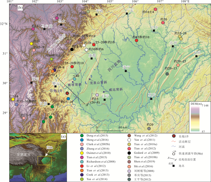
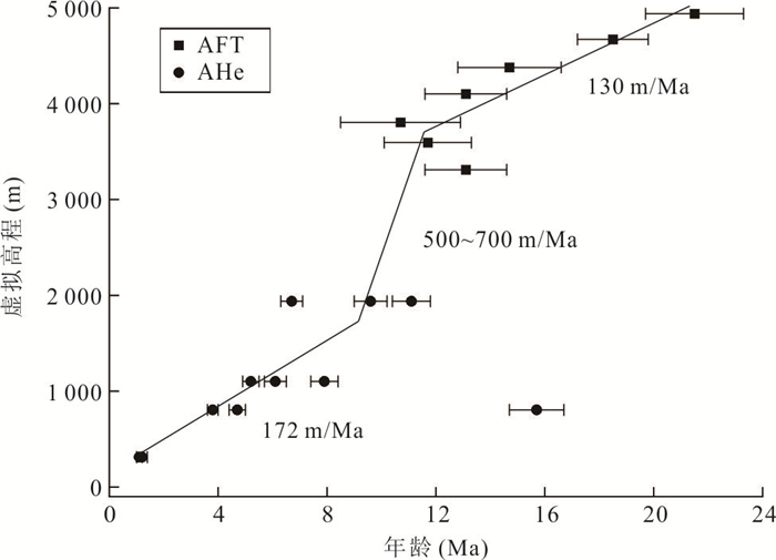
The uplift mechanism of the Cenozoic Longmenshan has two endmember modes: upper crustal shortening and lower crustal flow. The two modes will cause different tectonic deformation responses in the Sichuan basin and form different basin-mountain systems. In order to determine the tectonic deformation characteristics of the basin-mountain system in the southern Longmenshan and the frontal area and its dynamic indicative significance, seven sandstone samples from Well Ledi 1 in the southern Longmenshan frontal area were analyzed by low-temperature thermochronology (AFT and AHe) to constrain the exhumation characteristics of the front area. The results show that the shallow strata in the frontal area of the southern Longmenshan have experienced a rapid exhumation stage (~500 to 700 m/Ma) of ~10 to 11 Ma since the Miocene (~21 Ma). This rapid exhumation stage is synchronized with the rapid exhumation time revealed by the predecessors in the southern Longmenshan. Combined with regional geological data, it is believed that the thrust and nappe from the southern Longmenshan to the southeast at ~10 to 11 Ma, caused the tectonic stress to be transferred to the basin through the multi-layered detachment layers in the southwestern Sichuan basin, resulting in large-scale tectonic deformation and rapid exhumation in the front area. This knowledge indicates the uplift mechanism of the southern Longmenshan is the upper crustal shortening model.
The uplift mechanism of the Cenozoic Longmenshan has two endmember modes: upper crustal shortening and lower crustal flow. The two modes will cause different tectonic deformation responses in the Sichuan basin and form different basin-mountain systems. In order to determine the tectonic deformation characteristics of the basin-mountain system in the southern Longmenshan and the frontal area and its dynamic indicative significance, seven sandstone samples from Well Ledi 1 in the southern Longmenshan frontal area were analyzed by low-temperature thermochronology (AFT and AHe) to constrain the exhumation characteristics of the front area. The results show that the shallow strata in the frontal area of the southern Longmenshan have experienced a rapid exhumation stage (~500 to 700 m/Ma) of ~10 to 11 Ma since the Miocene (~21 Ma). This rapid exhumation stage is synchronized with the rapid exhumation time revealed by the predecessors in the southern Longmenshan. Combined with regional geological data, it is believed that the thrust and nappe from the southern Longmenshan to the southeast at ~10 to 11 Ma, caused the tectonic stress to be transferred to the basin through the multi-layered detachment layers in the southwestern Sichuan basin, resulting in large-scale tectonic deformation and rapid exhumation in the front area. This knowledge indicates the uplift mechanism of the southern Longmenshan is the upper crustal shortening model.


2023, 48(4): 1389-1404.
doi: 10.3799/dqkx.2022.169
Abstract:
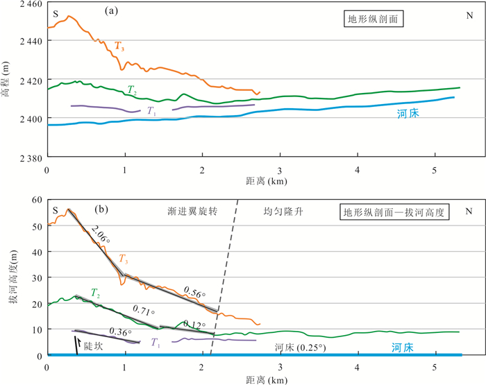
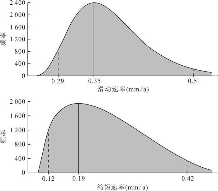
Subsurface fault geometry and deformation rates can be estimated by combining the pattern of terrace deformation with kinematic model and geomorphic age. Quantifying the geometry, kinematics and deformation rate of the thrust-and-fold belt is the key to exploring tectonic deformation and strain distribution of the Tianshan intermontane basin. This is demonstrated by the Bayan anticline in Youlududsi basin in the eastern Chinese Tianshan. The Kaidu River, flowing through the central part of the Bayan anticline, has formed three terrace levels at tilted fold backlimbs. Based on the field geological investigation, warped and tilted terraces in the Bayan anticline are characterized by broad, continuous backlimbs and abrupt forelimbs and suggest folding through progressive limb rotation of listric thrust model. Combining with the kinematic model and geomorphic age, the slip rate and crustal shortening rate of the underlying fault in Bayan anticline is (0.35-0.06)-(0.35+0.16) mm/a and (0.23-0.04)-(0.23+0.10) mm/a, respectively. This shortening represents over 15%-20% of the total deformation in Youludusi basin and ~2% of the 8.5±0.5 mm/a total shortening rate measured from GPS velocity across the entire range in East Tianshan.Therefore, a significant fraction of the total Quaternary deformation is accommodated within the central part of the East Tianshan.
Subsurface fault geometry and deformation rates can be estimated by combining the pattern of terrace deformation with kinematic model and geomorphic age. Quantifying the geometry, kinematics and deformation rate of the thrust-and-fold belt is the key to exploring tectonic deformation and strain distribution of the Tianshan intermontane basin. This is demonstrated by the Bayan anticline in Youlududsi basin in the eastern Chinese Tianshan. The Kaidu River, flowing through the central part of the Bayan anticline, has formed three terrace levels at tilted fold backlimbs. Based on the field geological investigation, warped and tilted terraces in the Bayan anticline are characterized by broad, continuous backlimbs and abrupt forelimbs and suggest folding through progressive limb rotation of listric thrust model. Combining with the kinematic model and geomorphic age, the slip rate and crustal shortening rate of the underlying fault in Bayan anticline is (0.35-0.06)-(0.35+0.16) mm/a and (0.23-0.04)-(0.23+0.10) mm/a, respectively. This shortening represents over 15%-20% of the total deformation in Youludusi basin and ~2% of the 8.5±0.5 mm/a total shortening rate measured from GPS velocity across the entire range in East Tianshan.Therefore, a significant fraction of the total Quaternary deformation is accommodated within the central part of the East Tianshan.


2023, 48(4): 1405-1420.
doi: 10.3799/dqkx.2022.272
Abstract:
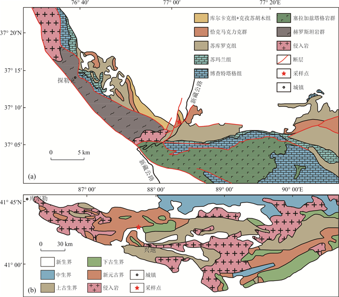
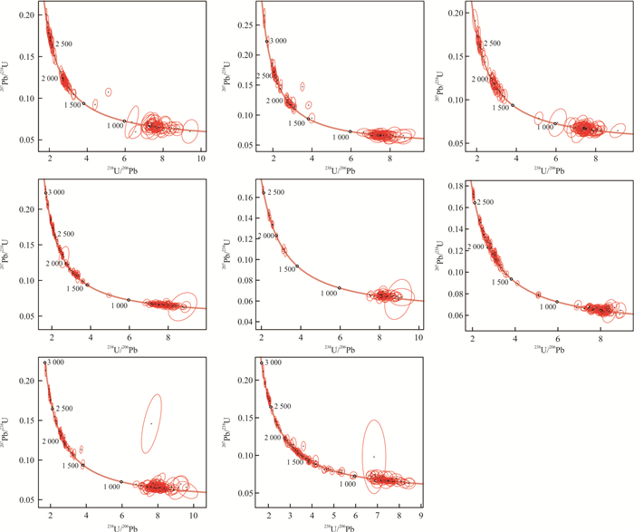
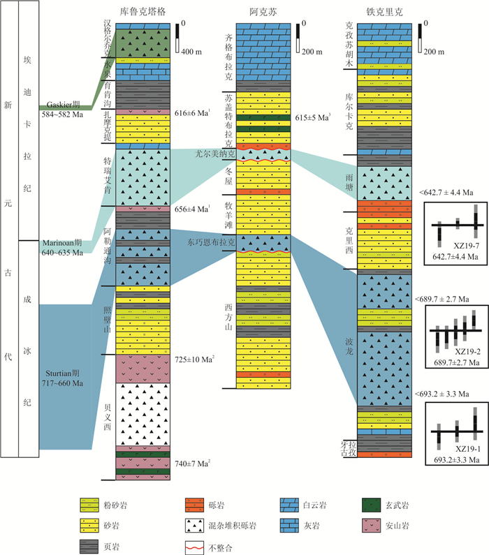
In recent years, it has been suggested that a Grenvillian orogenic belt developed in the Tarim Craton. However, associated magmatic and metamorphic evidence is absence. An orogeny provides massive detritus for the nearby basin, and hence would be reflected in the detrital zircon records.In this study, seven Neoproterozoic sandstone samples were obtained in the Tieklik area (Southwest Tarim) and the Quruqtagh area (Northeast Tarim), and studied through detrital zircon U-Pb dating. A total of 1 135 detrital zircon age data were obtained. In the Nanhua System, there are tillites in the Bolong Formation and Yutang Formation in the Southwest Tarim. The maximum depositional ages constrained by the detrital zircon records are 693.2±3.3 Ma and 642.7±4.4 Ma, respectively. Therefore, the Bolong tillite and the Yutang tillite can be correlated with the Sturtian glaciation and the Marinoan glaciation, respectively. Besides, previously published data were integrated to form a complete detrital zircon U-Pb age database of the Neoproterozoic in the Tarim craton. It shows that the detrital zircon ages are mainly distributed in the ranges of 700-900 Ma and 1 800-2 100 Ma, which is inconsistent with the age range of 980-1 250 Ma for the Grenvillian orogeny.Besides, the provenances of the Neoproterozoic clastic rocks in the three outcrop areas, i.e., the Aksu, Quruqtagh and Tieklik areas, are significantly different. It indicates that there were more than one source regions during the Nanhua-Sinian periods, which contradicts the hypothesis of a large-scale orogen across the craton. In brief, this study concludes from the detrital zircon records that no Grenvillian collisional orogen developed in the Tarim craton.
In recent years, it has been suggested that a Grenvillian orogenic belt developed in the Tarim Craton. However, associated magmatic and metamorphic evidence is absence. An orogeny provides massive detritus for the nearby basin, and hence would be reflected in the detrital zircon records.In this study, seven Neoproterozoic sandstone samples were obtained in the Tieklik area (Southwest Tarim) and the Quruqtagh area (Northeast Tarim), and studied through detrital zircon U-Pb dating. A total of 1 135 detrital zircon age data were obtained. In the Nanhua System, there are tillites in the Bolong Formation and Yutang Formation in the Southwest Tarim. The maximum depositional ages constrained by the detrital zircon records are 693.2±3.3 Ma and 642.7±4.4 Ma, respectively. Therefore, the Bolong tillite and the Yutang tillite can be correlated with the Sturtian glaciation and the Marinoan glaciation, respectively. Besides, previously published data were integrated to form a complete detrital zircon U-Pb age database of the Neoproterozoic in the Tarim craton. It shows that the detrital zircon ages are mainly distributed in the ranges of 700-900 Ma and 1 800-2 100 Ma, which is inconsistent with the age range of 980-1 250 Ma for the Grenvillian orogeny.Besides, the provenances of the Neoproterozoic clastic rocks in the three outcrop areas, i.e., the Aksu, Quruqtagh and Tieklik areas, are significantly different. It indicates that there were more than one source regions during the Nanhua-Sinian periods, which contradicts the hypothesis of a large-scale orogen across the craton. In brief, this study concludes from the detrital zircon records that no Grenvillian collisional orogen developed in the Tarim craton.


2023, 48(4): 1421-1440.
doi: 10.3799/dqkx.2023.019
Abstract:
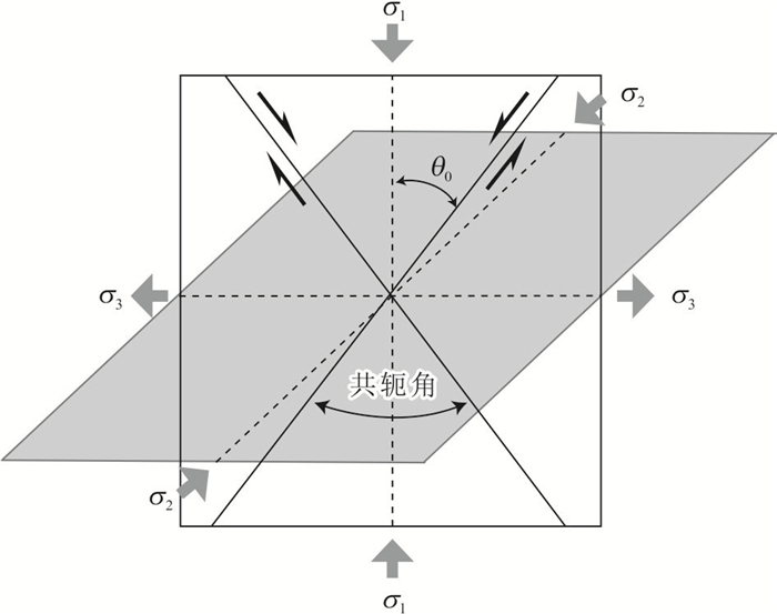
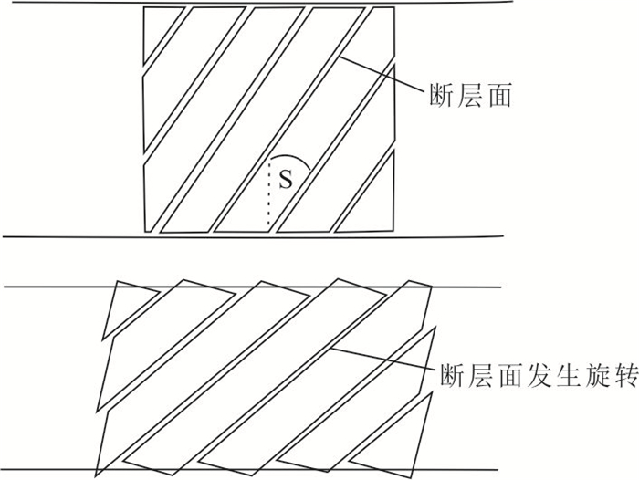
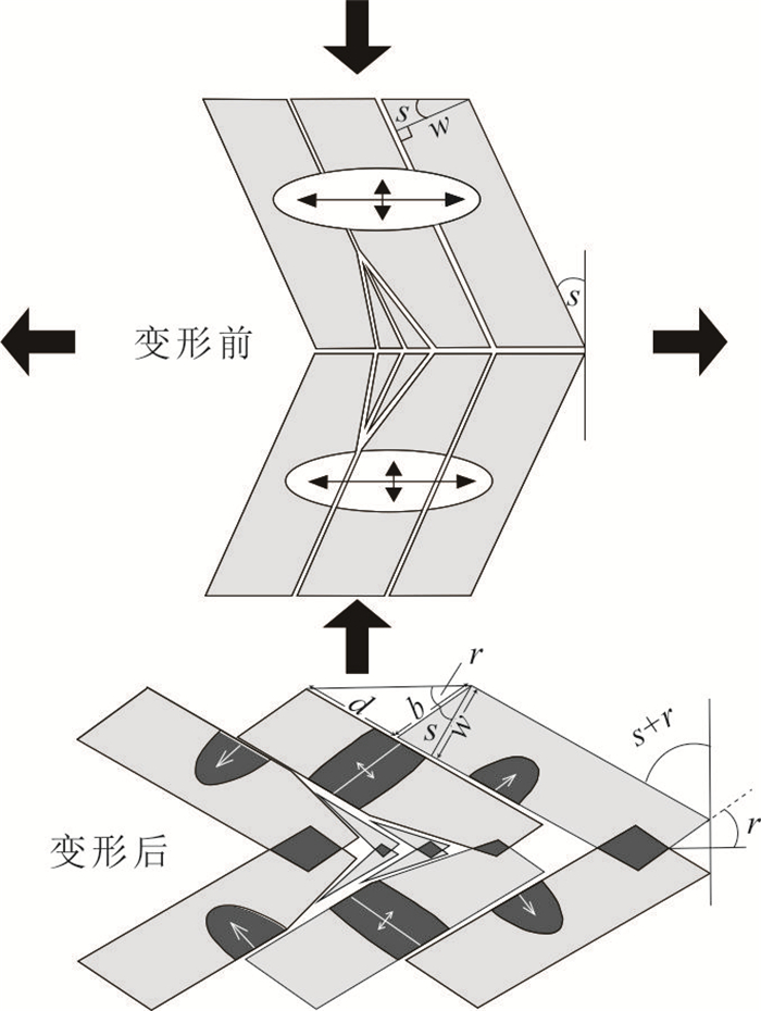
The V-shaped conjugate strike-slip fault system is defined as strike-slip faults with obtuse conjugate angles, whose opening side has an acute angle between the V-shaped faults, pointing to the direction of maximum extension. Previous studies on V-shaped conjugate strike-slip faults mostly focused on their development background and associated dynamic mechanisms. However, few literatures exist to comprehensively review the geometry and kinematics of V-shaped conjugate strike-slip faults. Here, we firstly summarize previous findings on the geometry, kinematic characteristics and formation mechanisms of existing V-shaped conjugate strike-slip faults, and then select the V-shaped conjugate strike-slip faults in the southeastern Tibetan Plateau for a case analysis. The characteristics of V-shaped conjugate strike-slip faults in the western United States, central and western Eurasian plate and central Tibet show a negative relation among conjugate angles and corresponding fault slip rates and fault lengths. The four formation mechanisms of the V-shaped conjugate strike-slip faults are 1) the fault planes experienced rotation after their formation, 2) the faults were reactivated along preexisting structurally weak zones, 3) the faults followed the paired general shear model and 4) the fault evolved according to the maximum-effective-moment criterion. Integrating analyses of geophysical data, elevation difference and geometric characteristics, we infer that the development of V-shaped conjugate strike-slip faults (Batang-Litang and Derong-Xiangcheng faults) in the Chuan-Dian block in the southeastern Tibetan Plateau, is consistent with gravitational spreading of the Tibetan lithosphere under the paired general shear model. This provides important insights for understanding the continuum crustal deformation in the southeastern Tibetan Plateau.
The V-shaped conjugate strike-slip fault system is defined as strike-slip faults with obtuse conjugate angles, whose opening side has an acute angle between the V-shaped faults, pointing to the direction of maximum extension. Previous studies on V-shaped conjugate strike-slip faults mostly focused on their development background and associated dynamic mechanisms. However, few literatures exist to comprehensively review the geometry and kinematics of V-shaped conjugate strike-slip faults. Here, we firstly summarize previous findings on the geometry, kinematic characteristics and formation mechanisms of existing V-shaped conjugate strike-slip faults, and then select the V-shaped conjugate strike-slip faults in the southeastern Tibetan Plateau for a case analysis. The characteristics of V-shaped conjugate strike-slip faults in the western United States, central and western Eurasian plate and central Tibet show a negative relation among conjugate angles and corresponding fault slip rates and fault lengths. The four formation mechanisms of the V-shaped conjugate strike-slip faults are 1) the fault planes experienced rotation after their formation, 2) the faults were reactivated along preexisting structurally weak zones, 3) the faults followed the paired general shear model and 4) the fault evolved according to the maximum-effective-moment criterion. Integrating analyses of geophysical data, elevation difference and geometric characteristics, we infer that the development of V-shaped conjugate strike-slip faults (Batang-Litang and Derong-Xiangcheng faults) in the Chuan-Dian block in the southeastern Tibetan Plateau, is consistent with gravitational spreading of the Tibetan lithosphere under the paired general shear model. This provides important insights for understanding the continuum crustal deformation in the southeastern Tibetan Plateau.


2023, 48(4): 1441-1460.
doi: 10.3799/dqkx.2022.335
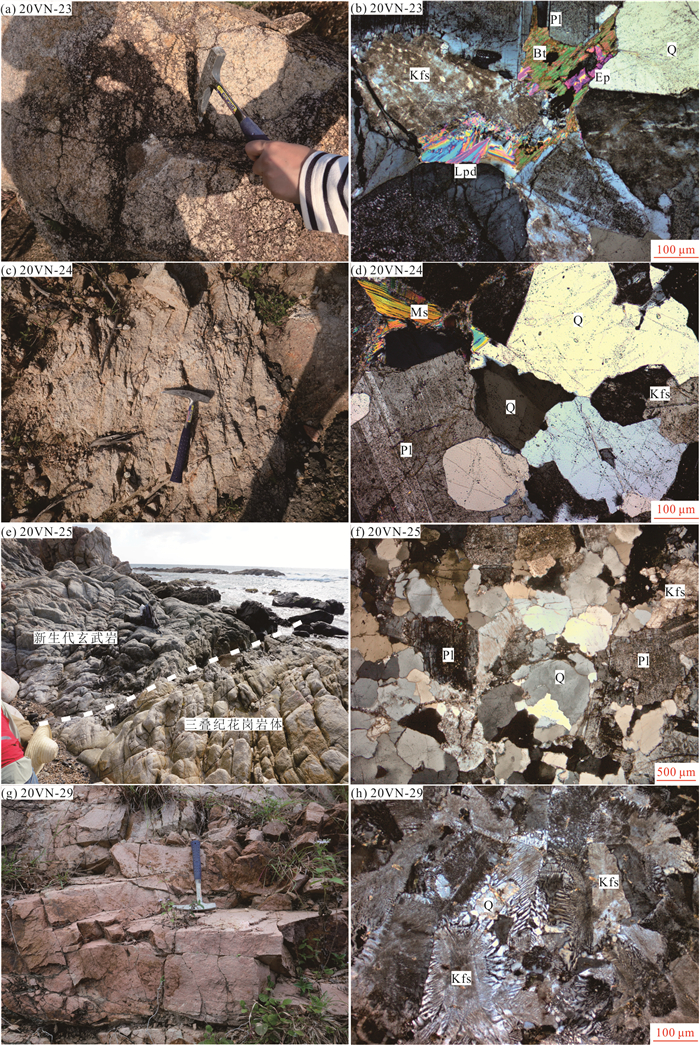
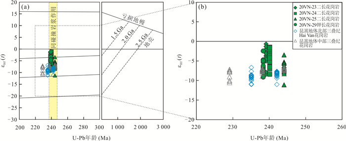
Abstract:
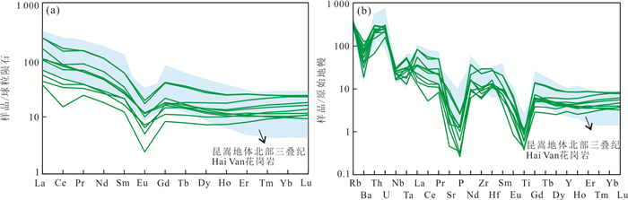
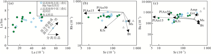
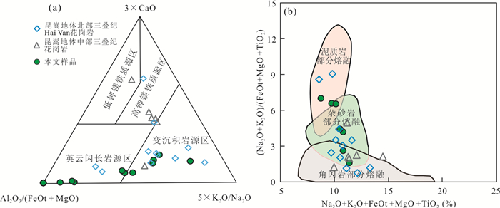
Kontum massif in the central Indochina records abundant Indosinian magmatism and tectonic thermal events, and is a key area for investigating the tectonic evolution of Paleotethyan ocean and subsequent collision between the Indochina and South China blocks. However, the origin of this Indosinian magmatism and its relationship with the Truong Son zone in the north are poorly constrained. In this study, it presents a set of petrographic, zircon U-Pb geochronological, zircon in-situ Hf isotopic, and whole-rock geochemical data for the granites from the Huyen Tuy An and Chu Loan area in the Kontum massif to constrain their crystallization ages, petrogenesis, and tectonic setting. Zircon U-Pb dating shows that the granites formed at 244-239 Ma. These samples contain monzogranites and K-feldspar granites and belong to the high-K calc-alkaline series. They are S-type granites with A/CNK values ranging from 1.03 to 1.21. These samples show enrichment of Rb, Th, and U, and depletion of Nb, Sr, Zr, and Ti, with obvious negative Eu anomalies (Eu/Eu*=0.24-0.56). Their negative zircon εHf(t) values ((-11.2)-(-0.7)) and Paleo- to Meso-Proterozoic Hf model ages (TDM2=1.98-1.31 Ga) indicate that these granites were derived from the partial melting of the Paleo- to Meso-Proterozoic metasedimentary rocks with a small amount of metaigneous component. Our new data along with the regional geological observations suggest that the Middle Triassic Van Canh granites in the Kontum massif were formed in a post-collisional setting in response to the collision between the Indochina and South China blocks following the closure of Song-Ma Paleotethyan branch. Our studies further suggest that the Truong Son zone can southerly extend to the central Kontum massif.
Kontum massif in the central Indochina records abundant Indosinian magmatism and tectonic thermal events, and is a key area for investigating the tectonic evolution of Paleotethyan ocean and subsequent collision between the Indochina and South China blocks. However, the origin of this Indosinian magmatism and its relationship with the Truong Son zone in the north are poorly constrained. In this study, it presents a set of petrographic, zircon U-Pb geochronological, zircon in-situ Hf isotopic, and whole-rock geochemical data for the granites from the Huyen Tuy An and Chu Loan area in the Kontum massif to constrain their crystallization ages, petrogenesis, and tectonic setting. Zircon U-Pb dating shows that the granites formed at 244-239 Ma. These samples contain monzogranites and K-feldspar granites and belong to the high-K calc-alkaline series. They are S-type granites with A/CNK values ranging from 1.03 to 1.21. These samples show enrichment of Rb, Th, and U, and depletion of Nb, Sr, Zr, and Ti, with obvious negative Eu anomalies (Eu/Eu*=0.24-0.56). Their negative zircon εHf(t) values ((-11.2)-(-0.7)) and Paleo- to Meso-Proterozoic Hf model ages (TDM2=1.98-1.31 Ga) indicate that these granites were derived from the partial melting of the Paleo- to Meso-Proterozoic metasedimentary rocks with a small amount of metaigneous component. Our new data along with the regional geological observations suggest that the Middle Triassic Van Canh granites in the Kontum massif were formed in a post-collisional setting in response to the collision between the Indochina and South China blocks following the closure of Song-Ma Paleotethyan branch. Our studies further suggest that the Truong Son zone can southerly extend to the central Kontum massif.


2023, 48(4): 1461-1480.
doi: 10.3799/dqkx.2022.174
Abstract:
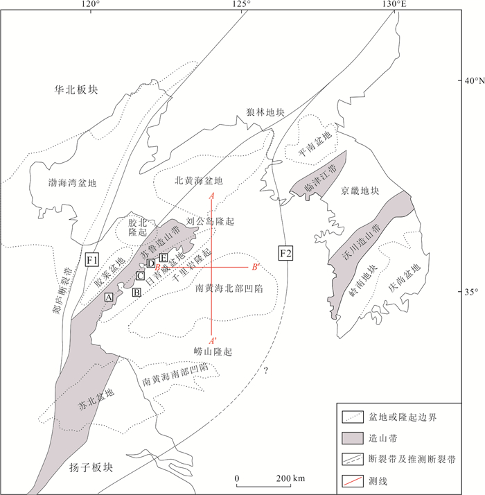
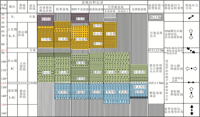
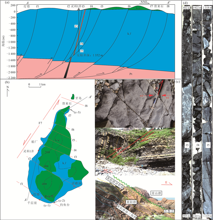
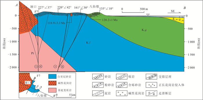
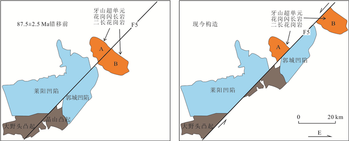
The subduction, rollbacking and the direction of the subduction of the Paleo-Pacific Plate had a significant influence on the development of the basins in the Yellow Sea and its adjacent areas. According to the drilling core data of the field profile and marine seismic profile, the sedimentation between different basins is compared and analyzed, and the changes of the stress field direction and main tectonic deformation framework in different periods are identified. Meanwhile, the main faults are defined, critical time nodes have provided evidence, and the research area's tectonic transition from the Jurassic to the Cretaceous is restored. The results indicate that: (1) Under the background of the subduction of the paleo-pacific plate, the basin has undergone multiple stages of 'extension' and 'compression' structural stress fields and under the joint control of the two main fault zones of the Tanlu fault zone F1 and the western Korean Peninsula fault zone F2. (2) During Laiyang period, passive rift was developed due to the stretching from south to north; At 125±1 Ma stage, thermal uplift extrusion caused slight tectonic inversion and formed angular unconformity in the uplift area; The volcanic arc basin with active rift was formed during the Qingshan period; At the extrusion stage of 87.5±2.5 Ma, large-scale sinistral strike-slip occurred and regional angular unconformity was formed; The thermal subsidence in Wang stage formed a large area depression with the nature of take-away slip and pull-apart; At the extrusion stage of 50±5 Ma, dextral strike-slip occurred mainly at F1 and F2 faults. (3) In this paper, the strike-slip amount in the extrusion stage is estimated, and the elongation and settlement rate in the extension stage are calculated. It is the first time to reconstruct the tectonic framework and basin prototype before the evolution of the Late Mesozoic compressive tectonic episode in the Yellow Sea and adjacent areas of China, and to explain the influence of the subduction of the Paleo-Pacific plate on the evolution of the tectonic framework in the Yellow Sea and adjacent areas.
The subduction, rollbacking and the direction of the subduction of the Paleo-Pacific Plate had a significant influence on the development of the basins in the Yellow Sea and its adjacent areas. According to the drilling core data of the field profile and marine seismic profile, the sedimentation between different basins is compared and analyzed, and the changes of the stress field direction and main tectonic deformation framework in different periods are identified. Meanwhile, the main faults are defined, critical time nodes have provided evidence, and the research area's tectonic transition from the Jurassic to the Cretaceous is restored. The results indicate that: (1) Under the background of the subduction of the paleo-pacific plate, the basin has undergone multiple stages of 'extension' and 'compression' structural stress fields and under the joint control of the two main fault zones of the Tanlu fault zone F1 and the western Korean Peninsula fault zone F2. (2) During Laiyang period, passive rift was developed due to the stretching from south to north; At 125±1 Ma stage, thermal uplift extrusion caused slight tectonic inversion and formed angular unconformity in the uplift area; The volcanic arc basin with active rift was formed during the Qingshan period; At the extrusion stage of 87.5±2.5 Ma, large-scale sinistral strike-slip occurred and regional angular unconformity was formed; The thermal subsidence in Wang stage formed a large area depression with the nature of take-away slip and pull-apart; At the extrusion stage of 50±5 Ma, dextral strike-slip occurred mainly at F1 and F2 faults. (3) In this paper, the strike-slip amount in the extrusion stage is estimated, and the elongation and settlement rate in the extension stage are calculated. It is the first time to reconstruct the tectonic framework and basin prototype before the evolution of the Late Mesozoic compressive tectonic episode in the Yellow Sea and adjacent areas of China, and to explain the influence of the subduction of the Paleo-Pacific plate on the evolution of the tectonic framework in the Yellow Sea and adjacent areas.


2023, 48(4): 1481-1495.
doi: 10.3799/dqkx.2022.298
Abstract:
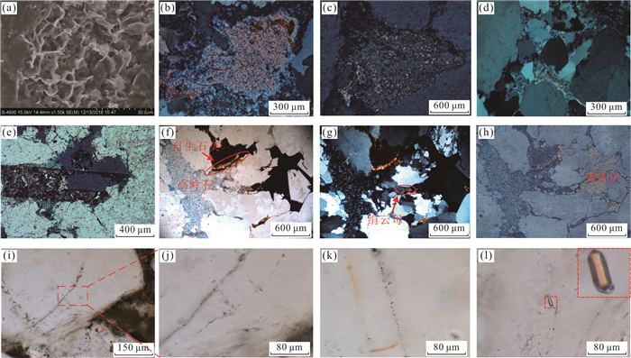
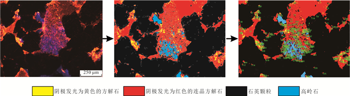
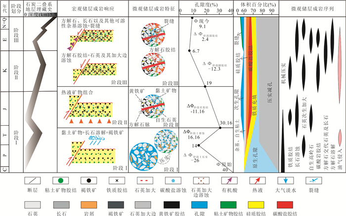
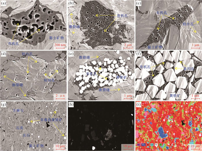
In this paper it aims to gain new insights into clastic buried hill reservoirs. For this purpose, the Permian sandstone reservoirs in Upper Shihezi Formation, Gubei low buried hill, Jiyang depression, was taken as the object. Referring to the diagenesis in the process of burial-lifting-reburning of the reservoirs, with the aid of techniques like core observation, casting sheet observation, scanning electron microscopy (SEM), cathode luminescence, carbon-oxygen isotope analysis and fluid inclusion. The results show that: It is found that the diagenetic evolution of the sandstone reservoir of Upper Shihezi Formation of Permian in Gubei buried hill of Jiyang Depression has gone through three stages from early to late. Stage I: Late Triassic and Early-Middle Jurassic, Gubei buried hill was uplifted and the Permian strata were denuded by the Indosinian movement, and the main diagenetic environment was shallow burial and uplift exposure denudation. The main diagenetic responses are feldspar dissolution, kaolinite cementation, stage ①quartz cementation and limonite invasion. Stage II: Jurassic and Cretaceous, the sinistral strike-slip movement occurred in the Tancheng-Lujiang fault zone, the strong tectonic activity accompanied by active volcanic activity, and the hydrothermal activity associated with volcanic activity greatly affected the reservoir. The diagenetic response is the development of stage ① carbonate cementation, stage ② quartz cementation, pyrite, sericite, chlorite and long columnar apatite. Stage Ⅲ: Cenozoic, under the action of regional transtensional stress, the burial depth of Gubei buried hill increased, the maturity of organic matter increased, and the diagenetic environment was dominated by organic acid. The diagenetic response was mainly from carbonate cementation and quartz dissolution in stage ② to carbonate dissolution and feldspar dissolution in late stage. The results of quantitative restoration of pore evolution show that the compaction and cementation in stages Ⅰ and Ⅱ have a great influence on the porosity, which decreases from 40% to 19%, and the diagenesis in early alkaline environment in stage Ⅲ has a destructive effect on the porosity of the reservoir, which decreases from 19% to 6.7%. After that, the porosity of the reservoir increased from 6.7% to 9.1% due to the dissolution reconstruction in acidic environment, and the secondary dissolution pores were developed and well preserved.
In this paper it aims to gain new insights into clastic buried hill reservoirs. For this purpose, the Permian sandstone reservoirs in Upper Shihezi Formation, Gubei low buried hill, Jiyang depression, was taken as the object. Referring to the diagenesis in the process of burial-lifting-reburning of the reservoirs, with the aid of techniques like core observation, casting sheet observation, scanning electron microscopy (SEM), cathode luminescence, carbon-oxygen isotope analysis and fluid inclusion. The results show that: It is found that the diagenetic evolution of the sandstone reservoir of Upper Shihezi Formation of Permian in Gubei buried hill of Jiyang Depression has gone through three stages from early to late. Stage I: Late Triassic and Early-Middle Jurassic, Gubei buried hill was uplifted and the Permian strata were denuded by the Indosinian movement, and the main diagenetic environment was shallow burial and uplift exposure denudation. The main diagenetic responses are feldspar dissolution, kaolinite cementation, stage ①quartz cementation and limonite invasion. Stage II: Jurassic and Cretaceous, the sinistral strike-slip movement occurred in the Tancheng-Lujiang fault zone, the strong tectonic activity accompanied by active volcanic activity, and the hydrothermal activity associated with volcanic activity greatly affected the reservoir. The diagenetic response is the development of stage ① carbonate cementation, stage ② quartz cementation, pyrite, sericite, chlorite and long columnar apatite. Stage Ⅲ: Cenozoic, under the action of regional transtensional stress, the burial depth of Gubei buried hill increased, the maturity of organic matter increased, and the diagenetic environment was dominated by organic acid. The diagenetic response was mainly from carbonate cementation and quartz dissolution in stage ② to carbonate dissolution and feldspar dissolution in late stage. The results of quantitative restoration of pore evolution show that the compaction and cementation in stages Ⅰ and Ⅱ have a great influence on the porosity, which decreases from 40% to 19%, and the diagenesis in early alkaline environment in stage Ⅲ has a destructive effect on the porosity of the reservoir, which decreases from 19% to 6.7%. After that, the porosity of the reservoir increased from 6.7% to 9.1% due to the dissolution reconstruction in acidic environment, and the secondary dissolution pores were developed and well preserved.


2023, 48(4): 1496-1516.
doi: 10.3799/dqkx.2022.177
Abstract:
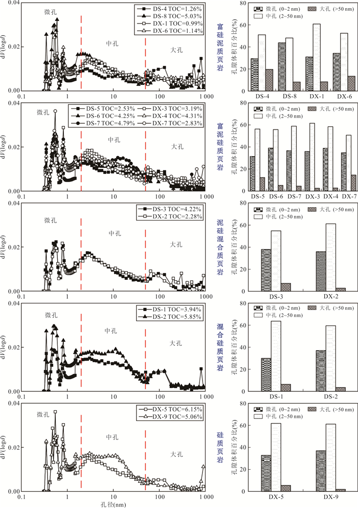
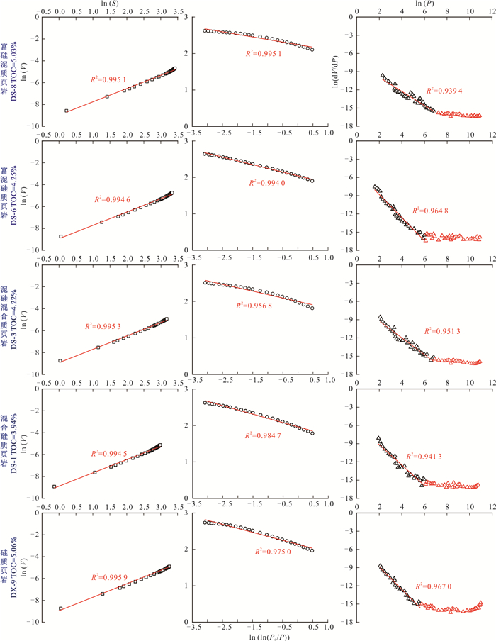
To clarify the micropore structure and fractal characteristics of deep overpressured organic-rich shale in Wufeng and Longmaxi Formations in Southeast Sichuan basin, in this work it takes the organic-rich shales in Wufeng and Longmaxi Formations from four typical wells in the Dingshan and Dongxi areas as the research object. After ascertaining the mineralogical and geochemical characteristics of shale rocks, high-resolution scanning electron microscope, low-temperature gas (N2, CO2) adsorption, and mercury intrusion porosimetry experiments are used to qualitatively and quantitatively characterize the micropore structure of organic shale from the Wufeng and Longmaxi Formations. Based on gas (CO2 and N2) adsorption, mercury intrusion porosimetry and fractal theory, the fractal dimensions of pores in shale are calculated, and the internal relations between pore structure parameters, mineral composition, total organic carbon (TOC) content and fractal dimension of shale in different lithofacies are discussed. Results show that organic pores, inorganic pores (intergranular pores and intragranular pores) and microfractures are widely developed in these shale samples from Wufeng and Longmaxi Formations in the Dingshan and Dongxi areas. The pore morphology is dominated by wedge-shaped, slit-shaped or some parallel plate pores. The pore size distribution is multimodal. Mesoporeis the main contributor to the total pore volume (accounting for approximately 59%), and micropores are the minor contributor to the total pore volume (accounting for approximately 35%). The contribution of macropore to the total pore volume is relatively small. Influenced by the differences of rock composition, TOC content and diagenesis, the pores of different shale lithofacies show various evolution characteristics, resulting in strong heterogeneity and complex pore structure. The pores of the Wufeng-Longmaxi shale in the study area have obvious multi-scale fractal characteristics, and the pore fractal dimension characteristics between shale lithofacies at different scales are different, reflecting the extremely strong heterogeneous characteristics. Among them, the micropore fractal dimension D1 and mesopore fractal dimension D2 of siliceous shale are the largest, developing a more complex micropore and mesopore pore structure network, which can provide a large number of gas adsorption sites and storage space. In contrast, silicon-rich argillaceous shale has the largest macropore fractal dimension D3, indicating that the macropore pore structure is relatively more complex, which can provide more pore space and facilitate the storage of free shale gas.
To clarify the micropore structure and fractal characteristics of deep overpressured organic-rich shale in Wufeng and Longmaxi Formations in Southeast Sichuan basin, in this work it takes the organic-rich shales in Wufeng and Longmaxi Formations from four typical wells in the Dingshan and Dongxi areas as the research object. After ascertaining the mineralogical and geochemical characteristics of shale rocks, high-resolution scanning electron microscope, low-temperature gas (N2, CO2) adsorption, and mercury intrusion porosimetry experiments are used to qualitatively and quantitatively characterize the micropore structure of organic shale from the Wufeng and Longmaxi Formations. Based on gas (CO2 and N2) adsorption, mercury intrusion porosimetry and fractal theory, the fractal dimensions of pores in shale are calculated, and the internal relations between pore structure parameters, mineral composition, total organic carbon (TOC) content and fractal dimension of shale in different lithofacies are discussed. Results show that organic pores, inorganic pores (intergranular pores and intragranular pores) and microfractures are widely developed in these shale samples from Wufeng and Longmaxi Formations in the Dingshan and Dongxi areas. The pore morphology is dominated by wedge-shaped, slit-shaped or some parallel plate pores. The pore size distribution is multimodal. Mesoporeis the main contributor to the total pore volume (accounting for approximately 59%), and micropores are the minor contributor to the total pore volume (accounting for approximately 35%). The contribution of macropore to the total pore volume is relatively small. Influenced by the differences of rock composition, TOC content and diagenesis, the pores of different shale lithofacies show various evolution characteristics, resulting in strong heterogeneity and complex pore structure. The pores of the Wufeng-Longmaxi shale in the study area have obvious multi-scale fractal characteristics, and the pore fractal dimension characteristics between shale lithofacies at different scales are different, reflecting the extremely strong heterogeneous characteristics. Among them, the micropore fractal dimension D1 and mesopore fractal dimension D2 of siliceous shale are the largest, developing a more complex micropore and mesopore pore structure network, which can provide a large number of gas adsorption sites and storage space. In contrast, silicon-rich argillaceous shale has the largest macropore fractal dimension D3, indicating that the macropore pore structure is relatively more complex, which can provide more pore space and facilitate the storage of free shale gas.


2023, 48(4): 1517-1531.
doi: 10.3799/dqkx.2022.081
Abstract:
Volcanic reservoir of the Upper Jurassic is a new exploration domain in the Hailaer basin. Recent exploration proves that the Upper Jurassic volcano-sedimentary rocks in Hailar basin have good prospects of oil and gas. The Western depression of the Hailar basin lies between the Derbugan and Erguna faults. The fault-related structures play an important role in the volcanic eruption and basin filling process. However, the detailed coupling relationships between fault-related structures and volcanic facies are unclear that affects the further exploration of volcanic reservoirs. This study uses well-seismic correlation, multi-attribute combination to analyze the drilling core, logging data and 2D/3D seismic data and summarizes the typical characteristics of logging and seismic reflection for the contrasting volcanic and sedimentary rocks. This study identifies volcanic edifice and lithofacies distribution in the Upper Jurassic of the western depression and reconstructs the volcanic paleogeography. The analyzed results indicate that the Derbugan and Erguna faults limited the eruption region of the Late Jurassic volcanos. Volcanic edifices predominantly occur in the outer zone of the western depression distributing along the NE-trending secondary faults in styles of beaded- and banded-shapes. The volcanic edifices show multi-center eruption patterns as the typical features of composite volcanos. The recognized parallel-fault assemblage, antithetical-fault assemblage, fault-transition zone and echelon-fault assemblage jointly control the volcanic structures and spatial distribution. Sedimentary rocks are mainly accommodated between volcanic edifices and faults, and the fault-related structures and volcanic paleogeomorphology jointly impact the distribution of sedimentary rocks.
Volcanic reservoir of the Upper Jurassic is a new exploration domain in the Hailaer basin. Recent exploration proves that the Upper Jurassic volcano-sedimentary rocks in Hailar basin have good prospects of oil and gas. The Western depression of the Hailar basin lies between the Derbugan and Erguna faults. The fault-related structures play an important role in the volcanic eruption and basin filling process. However, the detailed coupling relationships between fault-related structures and volcanic facies are unclear that affects the further exploration of volcanic reservoirs. This study uses well-seismic correlation, multi-attribute combination to analyze the drilling core, logging data and 2D/3D seismic data and summarizes the typical characteristics of logging and seismic reflection for the contrasting volcanic and sedimentary rocks. This study identifies volcanic edifice and lithofacies distribution in the Upper Jurassic of the western depression and reconstructs the volcanic paleogeography. The analyzed results indicate that the Derbugan and Erguna faults limited the eruption region of the Late Jurassic volcanos. Volcanic edifices predominantly occur in the outer zone of the western depression distributing along the NE-trending secondary faults in styles of beaded- and banded-shapes. The volcanic edifices show multi-center eruption patterns as the typical features of composite volcanos. The recognized parallel-fault assemblage, antithetical-fault assemblage, fault-transition zone and echelon-fault assemblage jointly control the volcanic structures and spatial distribution. Sedimentary rocks are mainly accommodated between volcanic edifices and faults, and the fault-related structures and volcanic paleogeomorphology jointly impact the distribution of sedimentary rocks.


2023, 48(4): 1532-1542.
doi: 10.3799/dqkx.2022.201
Abstract:
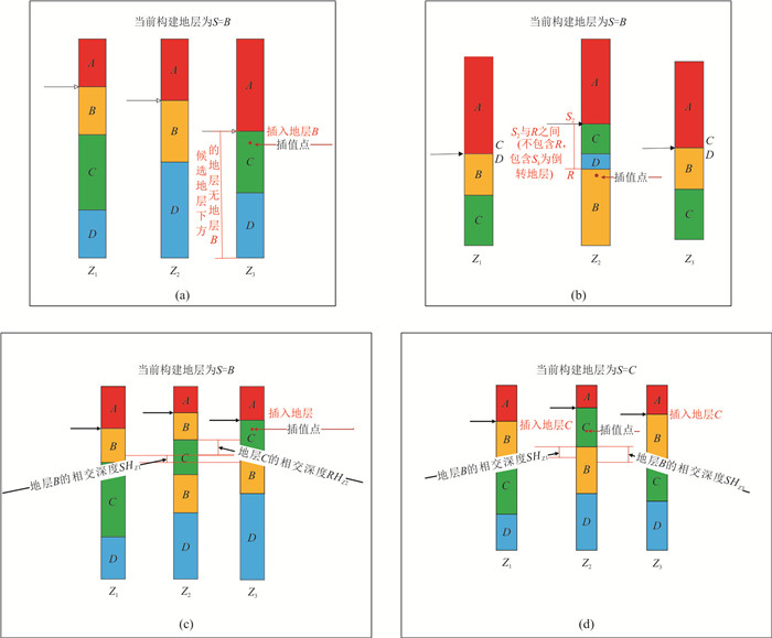
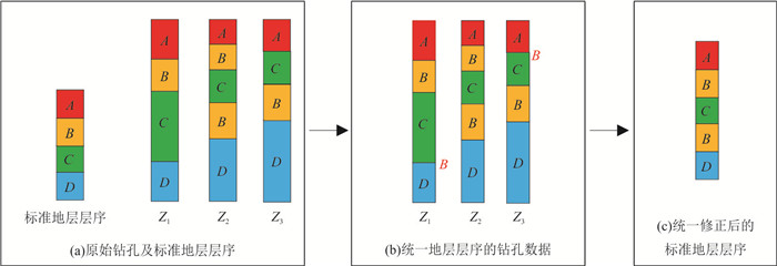
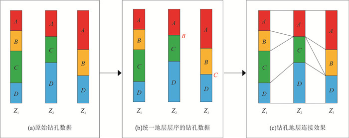
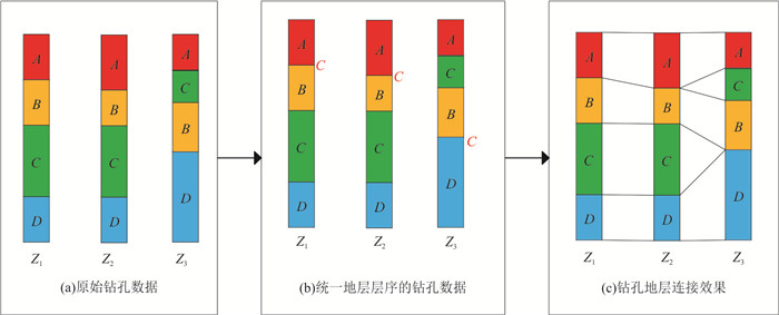
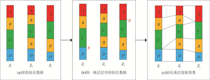
In the process of 3D geological model construction, due to the phenomena of stratum inversion, fold and joint caused by complex geological structure movement, the traditional stratum connection method does not consider the stratum corresponding to adjacent boreholes, which leads to the 3D model construction error. According to the problem, it puts forward a kind of complex stratigraphic sequence and unified revision and connection methods, introducing logic recursive unified stratigraphic sequence of ideas, drilling through stratigraphic math discriminant rule interpolation based on reverse calculation of layer thickness of zero insertion position, so as to unify all the drilling stratigraphic sequence and the revised standard stratigraphic sequence, inverted in the borehole, loss, repeated problems for processing. The results show that this method can fully solve the ambiguity of zero thickness layer insertion position and the ambiguity of reversed formation determination through the discussion of complex formation structures such as stratum missing, inversion and duplication and experimental verification. The algorithm can effectively solve complex stratum inversion and provide scientific basis for stratum connection in 3D geological modeling.
In the process of 3D geological model construction, due to the phenomena of stratum inversion, fold and joint caused by complex geological structure movement, the traditional stratum connection method does not consider the stratum corresponding to adjacent boreholes, which leads to the 3D model construction error. According to the problem, it puts forward a kind of complex stratigraphic sequence and unified revision and connection methods, introducing logic recursive unified stratigraphic sequence of ideas, drilling through stratigraphic math discriminant rule interpolation based on reverse calculation of layer thickness of zero insertion position, so as to unify all the drilling stratigraphic sequence and the revised standard stratigraphic sequence, inverted in the borehole, loss, repeated problems for processing. The results show that this method can fully solve the ambiguity of zero thickness layer insertion position and the ambiguity of reversed formation determination through the discussion of complex formation structures such as stratum missing, inversion and duplication and experimental verification. The algorithm can effectively solve complex stratum inversion and provide scientific basis for stratum connection in 3D geological modeling.


2023, 48(4): 1543-1550.
doi: 10.3799/dqkx.2022.426
Abstract:
Critical mineral resources refer to strategic mineral resources that are necessary for the sustainable development of modern society at present and near future but have high risks in terms of stable supply, mainly including the so-called “three rare metals” (rare earth elements, rare metals, rare dispersed metals), and other strategic metals, such as chromium, manganese, titanium, cobalt, nickel, and vanadium, as well as strategic non-metallic minerals, such as crystalline graphite, fluorite, talc, and boron.Qinghai Province is rich in critical metal deposits with a variety of ore deposit types and potential large resource reserves. In future study, it should focus on the fundamental geological theory of super-enrichment of the critical metals and efficient and modern technology for mineral exploration, including the following major tasks: to unravel the ore-forming controlling factors, ore formation regulations, the behavior of critical metals and their enrichment mechanisms; to investigate the occurrence state of rare metal elements, improve the utilization rate and reduce environmental pollution, and improve the level of exploration. Based on the situation of critical mineral resources in China and abroad, in this paper it puts forward some thoughts and suggestions on comprehensively improving the management, exploration, development and utilization level of critical mineral resources in Qinghai Province to secure the safety of mineral resources.
Critical mineral resources refer to strategic mineral resources that are necessary for the sustainable development of modern society at present and near future but have high risks in terms of stable supply, mainly including the so-called “three rare metals” (rare earth elements, rare metals, rare dispersed metals), and other strategic metals, such as chromium, manganese, titanium, cobalt, nickel, and vanadium, as well as strategic non-metallic minerals, such as crystalline graphite, fluorite, talc, and boron.Qinghai Province is rich in critical metal deposits with a variety of ore deposit types and potential large resource reserves. In future study, it should focus on the fundamental geological theory of super-enrichment of the critical metals and efficient and modern technology for mineral exploration, including the following major tasks: to unravel the ore-forming controlling factors, ore formation regulations, the behavior of critical metals and their enrichment mechanisms; to investigate the occurrence state of rare metal elements, improve the utilization rate and reduce environmental pollution, and improve the level of exploration. Based on the situation of critical mineral resources in China and abroad, in this paper it puts forward some thoughts and suggestions on comprehensively improving the management, exploration, development and utilization level of critical mineral resources in Qinghai Province to secure the safety of mineral resources.

2023, 48(4): 1551-1567.
doi: 10.3799/dqkx.2022.303
Abstract:
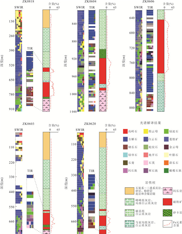
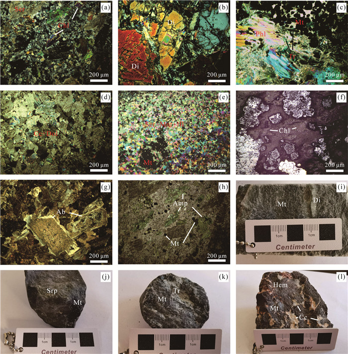
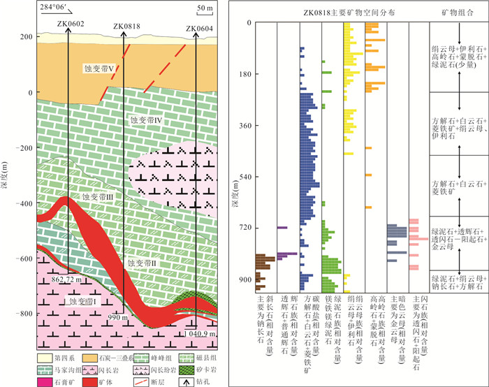
The Handan-Xingtai area is one of the important iron ore concentration areas in China. With the development of prospecting work, the prospecting effect of the traditional exploration technology is not ideal, new exploration methods and prospecting concepts are urgently needed. Infrared spectroscopy (SWIR+TIR) can be used to rapidly determine the types and spatial distribution of altered minerals, the changing law of spectral characteristic parameters of altered minerals is revealed, and the information related to mineralization further determined. Through infrared spectroscopy tests, it deciphered more than 20 minerals and determined five mineral zonation, from rock mass to surrounding rock is sericite-chlorite-calcite-albite zone (alteration zone Ⅰ), chlorite-serpentine-tremolite-actinite-diopside-chrysolite zone (alteration zone Ⅱ), calcite-dolomite-siderite zone (alteration zone Ⅲ), sericite-illite-calcite-dolomite-siderite zone (alteration zone Ⅳ), sericite-illite-kaolinite-montmorillonite zone (alteration zone Ⅴ). The study shows that it is closer to the mineralization areas, the lower the chlorite Fe-OH2250Pos, the lower the dolomite 6.45 μmPos and 11.2 μmPos reflection peak. Reduction of Al-OH2200FWHM of sericite minerals and the increase of Al-OH2170-IC of kaolinite minerals reflects the hotter fluid environment. Chlorite of low Fe-OH2250pos value (< 2 245 nm), dolomite of low 6.45μmPos value (< 6 440 nm) and dolomite of low 11.2 μmPos value (< 11 250 nm) are effective prospecting sign in Baijian. The decrease of sericite Al-OH2200FWHM value(30→22)and the increase of kaolinite Al-OH2170-IC value(0.2→2.8) both can determine whether there is a mineralization system in deep. These research results provide a scientific basis for mineral exploration in the Baijian mining area, and also provide new ideas and methods for prospecting for the same type of deposits in Han-Xing area.
The Handan-Xingtai area is one of the important iron ore concentration areas in China. With the development of prospecting work, the prospecting effect of the traditional exploration technology is not ideal, new exploration methods and prospecting concepts are urgently needed. Infrared spectroscopy (SWIR+TIR) can be used to rapidly determine the types and spatial distribution of altered minerals, the changing law of spectral characteristic parameters of altered minerals is revealed, and the information related to mineralization further determined. Through infrared spectroscopy tests, it deciphered more than 20 minerals and determined five mineral zonation, from rock mass to surrounding rock is sericite-chlorite-calcite-albite zone (alteration zone Ⅰ), chlorite-serpentine-tremolite-actinite-diopside-chrysolite zone (alteration zone Ⅱ), calcite-dolomite-siderite zone (alteration zone Ⅲ), sericite-illite-calcite-dolomite-siderite zone (alteration zone Ⅳ), sericite-illite-kaolinite-montmorillonite zone (alteration zone Ⅴ). The study shows that it is closer to the mineralization areas, the lower the chlorite Fe-OH2250Pos, the lower the dolomite 6.45 μmPos and 11.2 μmPos reflection peak. Reduction of Al-OH2200FWHM of sericite minerals and the increase of Al-OH2170-IC of kaolinite minerals reflects the hotter fluid environment. Chlorite of low Fe-OH2250pos value (< 2 245 nm), dolomite of low 6.45μmPos value (< 6 440 nm) and dolomite of low 11.2 μmPos value (< 11 250 nm) are effective prospecting sign in Baijian. The decrease of sericite Al-OH2200FWHM value(30→22)and the increase of kaolinite Al-OH2170-IC value(0.2→2.8) both can determine whether there is a mineralization system in deep. These research results provide a scientific basis for mineral exploration in the Baijian mining area, and also provide new ideas and methods for prospecting for the same type of deposits in Han-Xing area.


2023, 48(4): 1568-1586.
doi: 10.3799/dqkx.2022.358
Abstract:
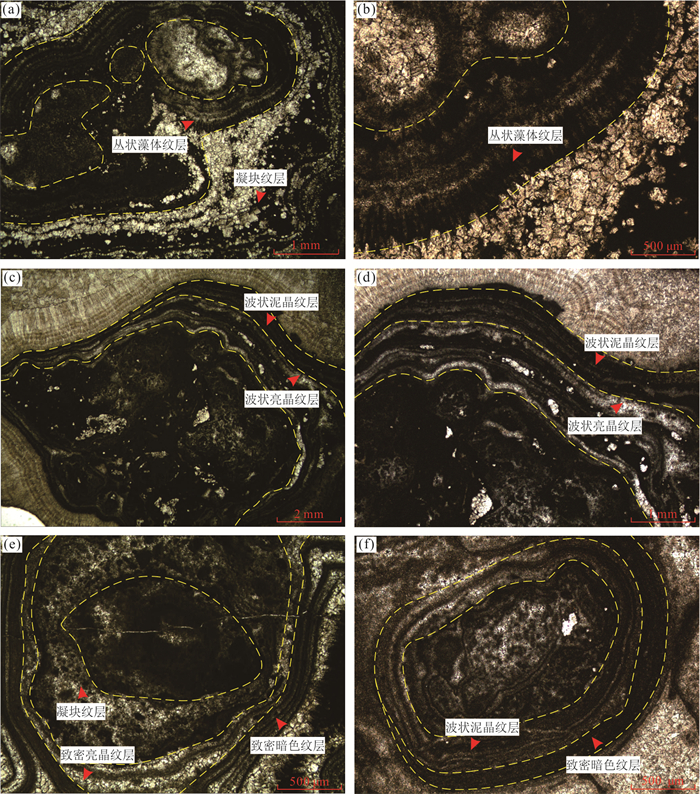
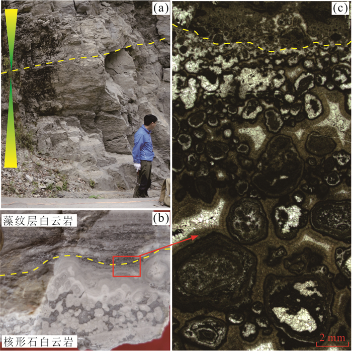
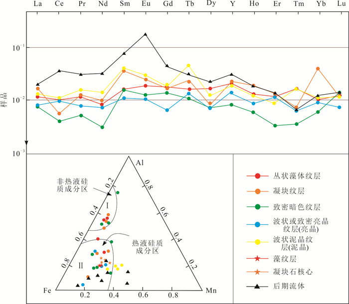
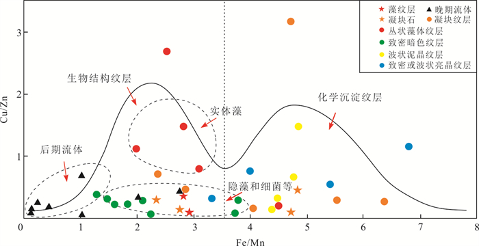
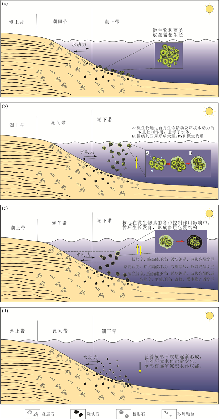
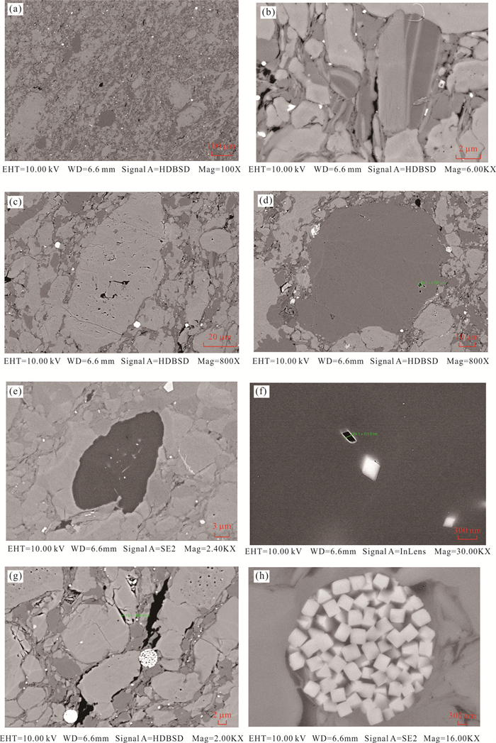
As a typical Precambrian microbial carbonate rock, the Sinian Dengying Formation oncoidal dolostone is one of the rock types of ancient deep oil and gas exploration in China. The study on the genetic model of oncoids has important guiding significance for the restoration of paleoenvironment, the study of paleo-water and its reservoir-forming model. In this paper, the oncoid of Dengying Formation is divided into six types based on its structural characteristics and genetic mechanism. Combined with petrology, sedimentology, geochemistry and other research methods, a comprehensive study of the distribution characteristics and depositional process of oncoids in the northern margin of the Sichuan basin has been carried out . The results show that the second member of Dengying Formation sedimented in the environment of subtidal flat and intertidal flat. The differences of hydrodynamic and microbial conditions affect the four kinds of formation mechanisms of oncoidal laminations: microbial growth, microbial calcification, bonding and capturing of microbial biofilm, and chemical precipitation. On the other hand, hydrodynamic conditions control the development thickness of laminations, morphological characteristics and associated rock types of the oncoids. The microbial activity habits affects the differentiation characteristics of the main trace and rare earth elements of the oncoids. The Fe/Mn ratio of the pooralgae lamina is higher than that of the rich algae lamina; the Cu/Zn ratio of the solid algae is higher than that of the non-solid algae; and the enrichment of rare earth elements in the lamina is generally lower than that the oncoidal nuclei. In summary, there are four formation mechanisms for oncoids in the second member of Dengying Formation, and they are jointly controlled by microbial and hydrodynamic conditions under sea level change.
As a typical Precambrian microbial carbonate rock, the Sinian Dengying Formation oncoidal dolostone is one of the rock types of ancient deep oil and gas exploration in China. The study on the genetic model of oncoids has important guiding significance for the restoration of paleoenvironment, the study of paleo-water and its reservoir-forming model. In this paper, the oncoid of Dengying Formation is divided into six types based on its structural characteristics and genetic mechanism. Combined with petrology, sedimentology, geochemistry and other research methods, a comprehensive study of the distribution characteristics and depositional process of oncoids in the northern margin of the Sichuan basin has been carried out . The results show that the second member of Dengying Formation sedimented in the environment of subtidal flat and intertidal flat. The differences of hydrodynamic and microbial conditions affect the four kinds of formation mechanisms of oncoidal laminations: microbial growth, microbial calcification, bonding and capturing of microbial biofilm, and chemical precipitation. On the other hand, hydrodynamic conditions control the development thickness of laminations, morphological characteristics and associated rock types of the oncoids. The microbial activity habits affects the differentiation characteristics of the main trace and rare earth elements of the oncoids. The Fe/Mn ratio of the pooralgae lamina is higher than that of the rich algae lamina; the Cu/Zn ratio of the solid algae is higher than that of the non-solid algae; and the enrichment of rare earth elements in the lamina is generally lower than that the oncoidal nuclei. In summary, there are four formation mechanisms for oncoids in the second member of Dengying Formation, and they are jointly controlled by microbial and hydrodynamic conditions under sea level change.


2023, 48(4): 1587-1602.
doi: 10.3799/dqkx.2022.437
Abstract:
This paper mainly takes the shale of Carboniferous Luzhai Formation of Guirongye 1 well as the research object, systematically evaluates the characteristics of high-quality shale reservoir of Luzhai Formation through the aspects of petrology, organic geochemistry, mineral composition, pore type, reservoir physical property and gas bearing property by using a variety of testing methods such as whole rock clay X-ray diffraction, argon ion polishing scanning electron microscope, nuclear magnetic resonance, field desorption and geochemical analysis, combined with logging interpretation results. The analysis results shows: ① the high-quality shale in the first member of Luzhai Formation of Carboniferous system is mainly black carbonaceous shale and gray black calcareous shale, which is mainly formed in deep-water facies under the sedimentary environment of rift trough. The high-quality shale has a continuous thickness and has a good shale gas sedimentary foundation; ②Luzhai shale formation has high organic carbon content, moderate degree of thermal evolution, and has good hydrocarbon generation basis and hydrocarbon generation capacity; ③Luzhai shale formation has good brittleness, well developed pore space, good desorption gas bearing property on site and good shale gas storage capacity; ④ The distribution of shale is continuous and stable, and the conditions of roof and floor are good. Fault reverse plugging is conducive to the enrichment and preservation of shale gas, which has good conditions for shale gas preservation. It is further confirmed that the Carboniferous Luzhai Formation in this area has good conditions for rich shale gas accumulation.
This paper mainly takes the shale of Carboniferous Luzhai Formation of Guirongye 1 well as the research object, systematically evaluates the characteristics of high-quality shale reservoir of Luzhai Formation through the aspects of petrology, organic geochemistry, mineral composition, pore type, reservoir physical property and gas bearing property by using a variety of testing methods such as whole rock clay X-ray diffraction, argon ion polishing scanning electron microscope, nuclear magnetic resonance, field desorption and geochemical analysis, combined with logging interpretation results. The analysis results shows: ① the high-quality shale in the first member of Luzhai Formation of Carboniferous system is mainly black carbonaceous shale and gray black calcareous shale, which is mainly formed in deep-water facies under the sedimentary environment of rift trough. The high-quality shale has a continuous thickness and has a good shale gas sedimentary foundation; ②Luzhai shale formation has high organic carbon content, moderate degree of thermal evolution, and has good hydrocarbon generation basis and hydrocarbon generation capacity; ③Luzhai shale formation has good brittleness, well developed pore space, good desorption gas bearing property on site and good shale gas storage capacity; ④ The distribution of shale is continuous and stable, and the conditions of roof and floor are good. Fault reverse plugging is conducive to the enrichment and preservation of shale gas, which has good conditions for shale gas preservation. It is further confirmed that the Carboniferous Luzhai Formation in this area has good conditions for rich shale gas accumulation.


2023, 48(4): 1603-1633.
doi: 10.3799/dqkx.2022.307
Abstract:
As a precious cultural heritage, the grotto temples seriously deteriorate due to the long-term influence of internal and external factors, leading to instability and failure of rock mass as common occurrence. In order to better carry out the protection of grotto cultural relics, the research results on the deterioration and instability of grotto temple rock mass were systematically reviewed. On the basis of expounding the researches on the degradation and failure of grotto temple rock mass, the deterioration and instability mechanism of grotto rock mass under the action of various factors were summarized from seven aspects, which were diagenetic environment and regional geology, regional environmental evolution, soluble salt, water environment, biological action, cave shape and multi-factor coupling. It is pointed out that the fundamental reason of degradation and instability of grotto temple rock mass is the coupling effects of mechanical, physical, chemical and biological actions caused by multiple factors. These effects are often manifested as the evolution of generation, expansion, connection and network formation of the internal microstructure in rock mass, and lead to the cumulative and instantaneous failure of grotto temple rock mass. The degradation and instability of grotto temple rock mass show diversity and regional differences, and the research ideas can be used for reference. The research needs of grotto temple rock mass protection in multi-scale, multi-means, multi-factor coupling and multi-regional combination are prospected. The review can not only provide references for related research work, but also provide basis for the formulation of protection policy of grotto temples.
As a precious cultural heritage, the grotto temples seriously deteriorate due to the long-term influence of internal and external factors, leading to instability and failure of rock mass as common occurrence. In order to better carry out the protection of grotto cultural relics, the research results on the deterioration and instability of grotto temple rock mass were systematically reviewed. On the basis of expounding the researches on the degradation and failure of grotto temple rock mass, the deterioration and instability mechanism of grotto rock mass under the action of various factors were summarized from seven aspects, which were diagenetic environment and regional geology, regional environmental evolution, soluble salt, water environment, biological action, cave shape and multi-factor coupling. It is pointed out that the fundamental reason of degradation and instability of grotto temple rock mass is the coupling effects of mechanical, physical, chemical and biological actions caused by multiple factors. These effects are often manifested as the evolution of generation, expansion, connection and network formation of the internal microstructure in rock mass, and lead to the cumulative and instantaneous failure of grotto temple rock mass. The degradation and instability of grotto temple rock mass show diversity and regional differences, and the research ideas can be used for reference. The research needs of grotto temple rock mass protection in multi-scale, multi-means, multi-factor coupling and multi-regional combination are prospected. The review can not only provide references for related research work, but also provide basis for the formulation of protection policy of grotto temples.


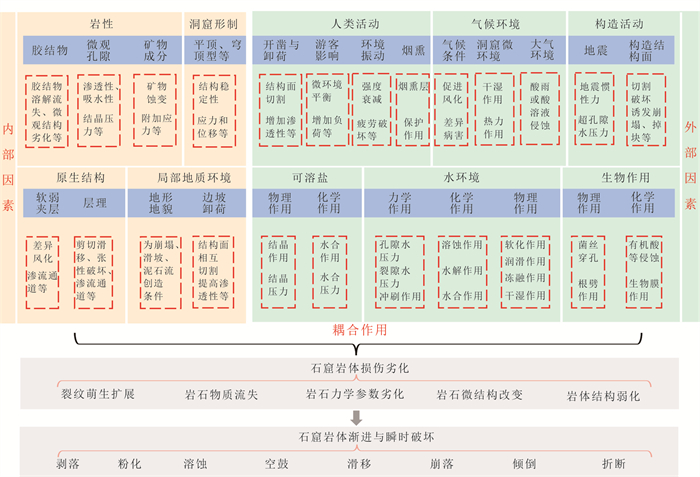
2023, 48(4): 1634-1648.
doi: 10.3799/dqkx.2022.360
Abstract:
Landslide dam is a common geological disaster in mountainous area. Once breach, it would pose a serious threat to the lives and property safety of downstream people. In emergency response, it is necessary to rapidly and accurately predict the landslide dam breach hydrograph and morphology evolution. However, most of the state-of-the-art numerical models for landslide dam breaching cannot fully consider the geomorphological characteristics of the landslide dam, as well as the breach process under complicated topography. In this paper, the Reynolds-averaged Navier-Stokes equations combined with the renormalization group k-ε turbulence model were used to analyze the breach flow under the complex topography. Meanwhile, the sediment transport equations for bedload and suspended load were employed to simulate the breach morphology evolution process. The "11·03" Baige landslide dam failure case with detailed survey and hydrological data was selected as the representative for back analysis. The comparison of the calculated and measured results on breach hydrographs, hydrodynamic characteristics during dam breaching, and final breach morphologies show that the numerical simulation results can present good performance on landslide dam breach process, which testified to the rationality of the model.
Landslide dam is a common geological disaster in mountainous area. Once breach, it would pose a serious threat to the lives and property safety of downstream people. In emergency response, it is necessary to rapidly and accurately predict the landslide dam breach hydrograph and morphology evolution. However, most of the state-of-the-art numerical models for landslide dam breaching cannot fully consider the geomorphological characteristics of the landslide dam, as well as the breach process under complicated topography. In this paper, the Reynolds-averaged Navier-Stokes equations combined with the renormalization group k-ε turbulence model were used to analyze the breach flow under the complex topography. Meanwhile, the sediment transport equations for bedload and suspended load were employed to simulate the breach morphology evolution process. The "11·03" Baige landslide dam failure case with detailed survey and hydrological data was selected as the representative for back analysis. The comparison of the calculated and measured results on breach hydrographs, hydrodynamic characteristics during dam breaching, and final breach morphologies show that the numerical simulation results can present good performance on landslide dam breach process, which testified to the rationality of the model.


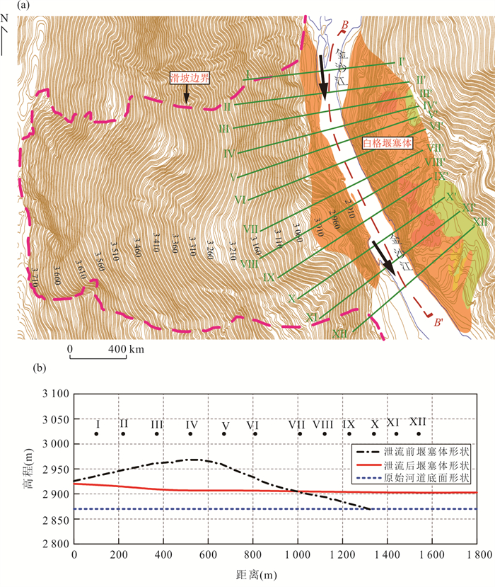
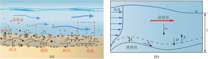

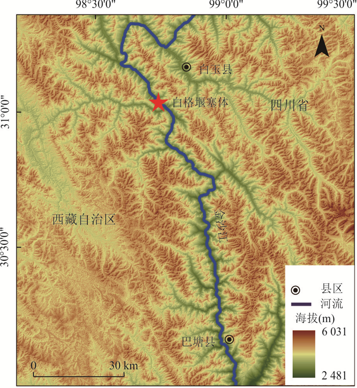
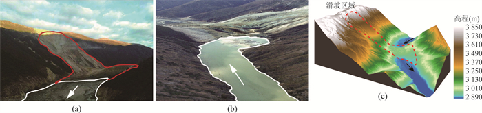


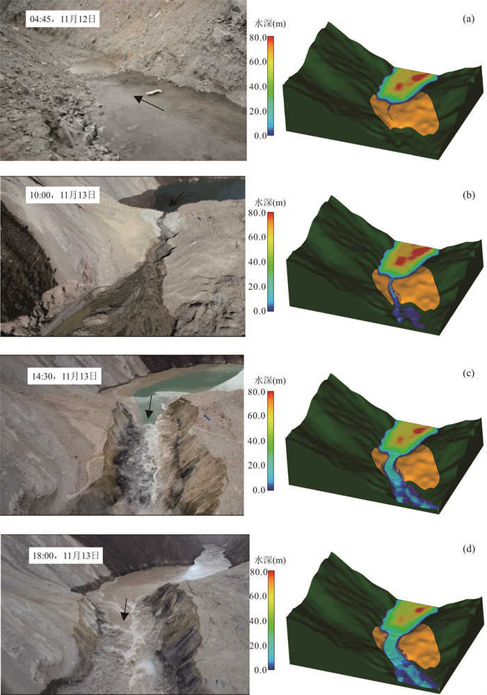
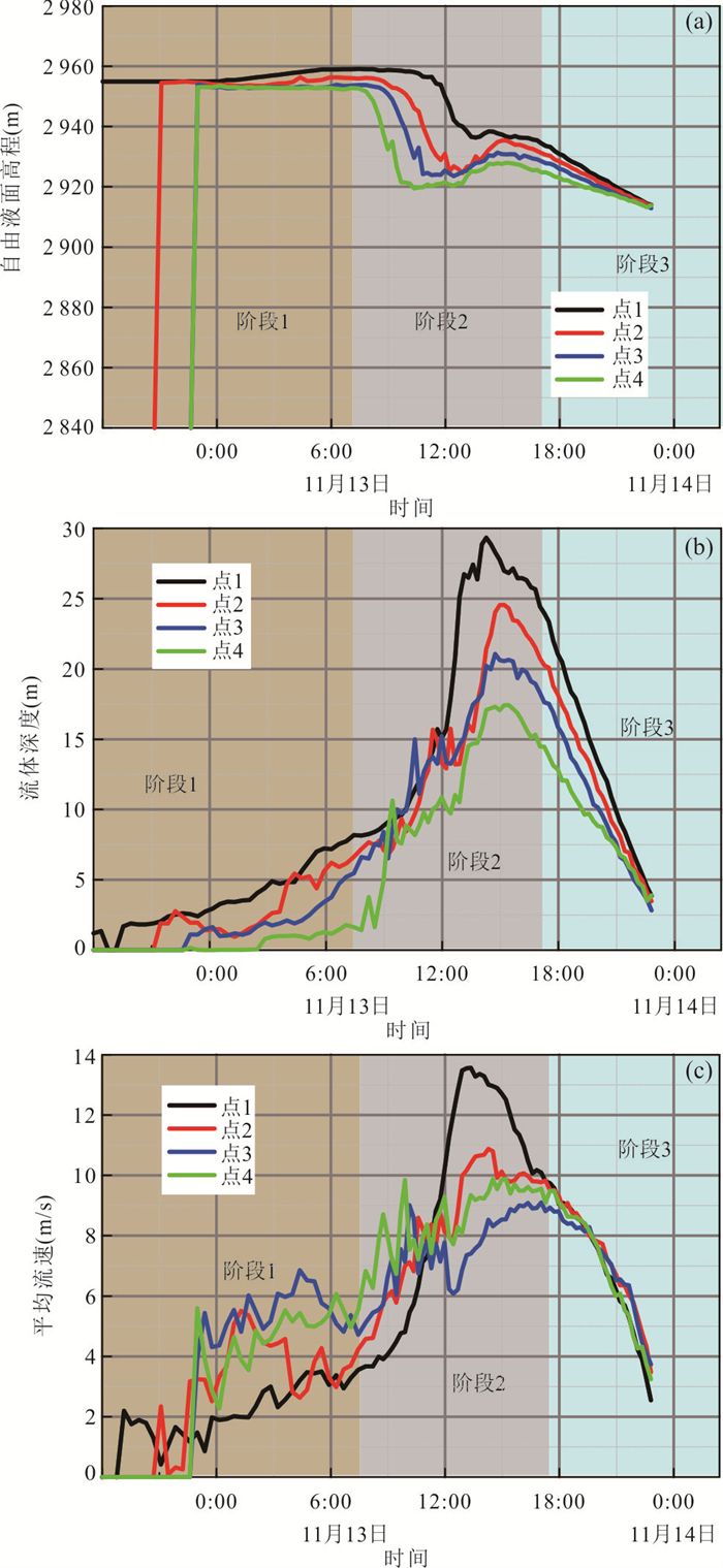

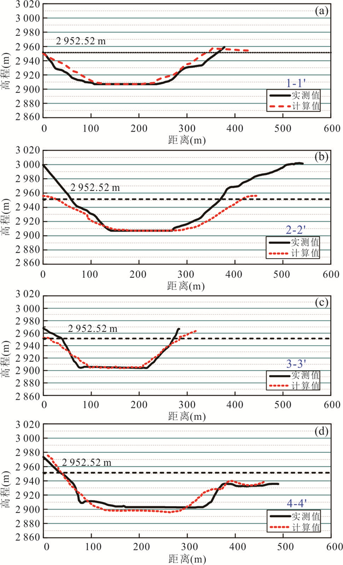
2023, 48(4): 1649-1656.
doi: 10.3799/dqkx.2022.115
Abstract:
Iron cycling mediated by iron-reducing bacteria is an important factor driving material cycle in the surface system of earth. H2O2 naturally generated and artificially injected into the subsurface environment may affect the activity and function of iron-reducing bacteria through oxidative stress, but the response and mechanism of iron-reducing bacteria to H2O2 disturbance is still unclear. In this study, Shewanella oneidensis MR-1 was chosen as a representative iron-reducing bacterium. In combination with batch experiments and RNA-seq analysis, the changes of MR-1 activity and function under different concentrations of H2O2 and its regulatory mechanism were investigated. Results show that MR-1 could resist H2O2 stress effectively, and H2O2 enhanced the Fe(Ⅲ)-reducing ability of MR-1. RNA-seq results show that MR-1 maintained in an anti-stress state infacing to H2O2 disturbance, which could resist the negative effects of H2O2 by actively oxidizing organic matter to provide energy and promoting the synthesis of catalase.
Iron cycling mediated by iron-reducing bacteria is an important factor driving material cycle in the surface system of earth. H2O2 naturally generated and artificially injected into the subsurface environment may affect the activity and function of iron-reducing bacteria through oxidative stress, but the response and mechanism of iron-reducing bacteria to H2O2 disturbance is still unclear. In this study, Shewanella oneidensis MR-1 was chosen as a representative iron-reducing bacterium. In combination with batch experiments and RNA-seq analysis, the changes of MR-1 activity and function under different concentrations of H2O2 and its regulatory mechanism were investigated. Results show that MR-1 could resist H2O2 stress effectively, and H2O2 enhanced the Fe(Ⅲ)-reducing ability of MR-1. RNA-seq results show that MR-1 maintained in an anti-stress state infacing to H2O2 disturbance, which could resist the negative effects of H2O2 by actively oxidizing organic matter to provide energy and promoting the synthesis of catalase.