2023 Vol. 48, No. 8
Display Method:
Evolution of Terrestrial Triassic Ichnofossils and Ecological Significance in Western Henan Province
2023, 48(8): 2807-2821.
doi: 10.3799/dqkx.2021.078
 PDF 29818KB
Abstract:
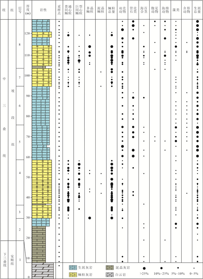
In this paper, the characteristics and variations of the Triassic terrestrial ichnofossils in western Henan Province were analyzed in terms of the abundance, ichnodiversity, biodisturbance index, behavior habits and food⁃feeding strategy of the trace⁃making organisms, burrow size and ichnofabric tiering. Ichnofossils developing in the study area during Early and Middle Triassic recorded the evolution of benthic communities from survival to recovery and radiation after the Permian⁃Triassic Mass Extinction (PTME). It reflected by the enlargement of metazoan's body size, the complicatedness of behavior habits and food⁃feeding strategy, the expansion of living space from the surficial tier and semi⁃infaunal tier to shallow, middle and deep tier, the increasement of ecological space occupying rate, the enhancement of the ability to modify and utilize the sedimentary environment gradually. The variations of the Late Triassic ichnofossils tend to be stable with fluctuation. The sedimentary environment was a crucial influence on the evolution of ichnofossils in Chunshuyao Formation, and the enhancement of the ichnodiversity and complexity of ichnofossils in Tanzhuang Formation was the joint work of the giant monsoon, sedimentary environment and biological factors.
In this paper, the characteristics and variations of the Triassic terrestrial ichnofossils in western Henan Province were analyzed in terms of the abundance, ichnodiversity, biodisturbance index, behavior habits and food⁃feeding strategy of the trace⁃making organisms, burrow size and ichnofabric tiering. Ichnofossils developing in the study area during Early and Middle Triassic recorded the evolution of benthic communities from survival to recovery and radiation after the Permian⁃Triassic Mass Extinction (PTME). It reflected by the enlargement of metazoan's body size, the complicatedness of behavior habits and food⁃feeding strategy, the expansion of living space from the surficial tier and semi⁃infaunal tier to shallow, middle and deep tier, the increasement of ecological space occupying rate, the enhancement of the ability to modify and utilize the sedimentary environment gradually. The variations of the Late Triassic ichnofossils tend to be stable with fluctuation. The sedimentary environment was a crucial influence on the evolution of ichnofossils in Chunshuyao Formation, and the enhancement of the ichnodiversity and complexity of ichnofossils in Tanzhuang Formation was the joint work of the giant monsoon, sedimentary environment and biological factors.


2023, 48(8): 2822-2836.
doi: 10.3799/dqkx.2023.087
Abstract:
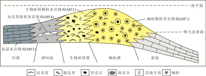
Giant ooids have been considered as abnormal sediment and distributed globally in the aftermath of the end-Permian mass extinction, and represent a marine carbonate supersaturated state which is unfavourable to the survival of metazoans. The marine environment returned to normal in the early Middle Triassic when abnormal sediments became rare. However, the discovery of giant ooids in the early Middle Triassic at the Poduan section, Ceheng, Guizhou Province, could give us more insights into the marine environmental conditions during that time. In this study, the sedimentary microfacies and fabrics of the carbonate rocks at the bottom of the Poduan section were analyzed. The sedimentary environments of the giant ooid-bearing beds were comprehensively studied based on the oolitic characteristics, oolitic content, bioclastic content and sedimentary microfacies. It can be considered that there are two oolitic enrichment periods. Four kinds of oolitic grains have been found at the Poduan section, including common concentric oolitic grains, giant concentric oolitic grains, polycrystalline oolitic grains and mud crystal oolitic grains. Four sedimentary microfacies were identified based on rock structure and carbonate particle characteristics and could represent the interbedded deposition of platform margin oolitic shoal and bioclastic shoal. The development of giant ooids in this area indicated that the marine carbonate saturation is still very high and the abnormal marine environment occurred in this area during the early Middle Triassic. It suggests that there were obvious regional differences in the global marine environment during the Middle Triassic, which is an important reason for the complexity of the model of biotic recovery and radiation.
Giant ooids have been considered as abnormal sediment and distributed globally in the aftermath of the end-Permian mass extinction, and represent a marine carbonate supersaturated state which is unfavourable to the survival of metazoans. The marine environment returned to normal in the early Middle Triassic when abnormal sediments became rare. However, the discovery of giant ooids in the early Middle Triassic at the Poduan section, Ceheng, Guizhou Province, could give us more insights into the marine environmental conditions during that time. In this study, the sedimentary microfacies and fabrics of the carbonate rocks at the bottom of the Poduan section were analyzed. The sedimentary environments of the giant ooid-bearing beds were comprehensively studied based on the oolitic characteristics, oolitic content, bioclastic content and sedimentary microfacies. It can be considered that there are two oolitic enrichment periods. Four kinds of oolitic grains have been found at the Poduan section, including common concentric oolitic grains, giant concentric oolitic grains, polycrystalline oolitic grains and mud crystal oolitic grains. Four sedimentary microfacies were identified based on rock structure and carbonate particle characteristics and could represent the interbedded deposition of platform margin oolitic shoal and bioclastic shoal. The development of giant ooids in this area indicated that the marine carbonate saturation is still very high and the abnormal marine environment occurred in this area during the early Middle Triassic. It suggests that there were obvious regional differences in the global marine environment during the Middle Triassic, which is an important reason for the complexity of the model of biotic recovery and radiation.


2023, 48(8): 2837-2850.
doi: 10.3799/dqkx.2022.420
Abstract:
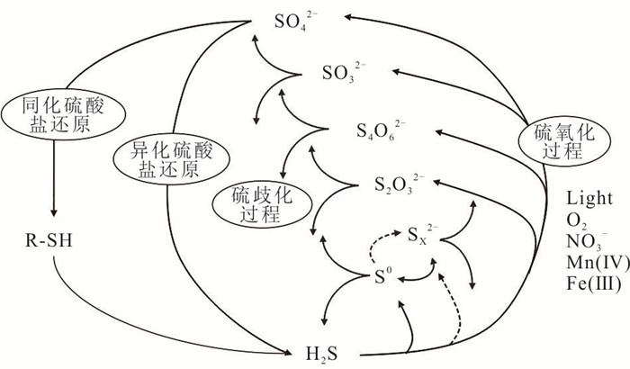
The isotopic preferences exhibited by microorganisms during the utilization of sulfur-containing materials result in sulfur isotopic fractionation in metabolites, Consequently, sulfur isotopes in the geological record can serve as indicators of microbial activity and redox conditions in the paleo-oceans and atmospheres. Conventionally, significant isotopic fractionation has been associated with microbially mediated sulfur reduction and sulfur disproportionation, while the fractionation effect caused by microbial sulfur oxidation processes has considered less evident. However, recent research has shown that one of sulfur-oxidizing bacteria can produce substantial sulfur isotopic fractionation, necessitating a reassessment of sulfur oxidation processes in the geological record. This paper provides a comprehensive review of sulfur isotopic fractionation effects in microbial anoxygenic photosynthetic sulfur oxidation processes and its geological implications, which includes the distribution and function of sulfur-oxidizing microorganisms and Chloroflexota, the sulfur isotopic fractionation effect of microbially mediated sulfur oxidation processes, and the geological record of sulfur isotopic fractionation studies related to microbial sulfur oxidation processes. Finally, the current status and future directions of research on sulfur isotopic fractionation mediated by microbial anoxygenic photosynthetic sulfur oxidation processes are summarized and presented.
The isotopic preferences exhibited by microorganisms during the utilization of sulfur-containing materials result in sulfur isotopic fractionation in metabolites, Consequently, sulfur isotopes in the geological record can serve as indicators of microbial activity and redox conditions in the paleo-oceans and atmospheres. Conventionally, significant isotopic fractionation has been associated with microbially mediated sulfur reduction and sulfur disproportionation, while the fractionation effect caused by microbial sulfur oxidation processes has considered less evident. However, recent research has shown that one of sulfur-oxidizing bacteria can produce substantial sulfur isotopic fractionation, necessitating a reassessment of sulfur oxidation processes in the geological record. This paper provides a comprehensive review of sulfur isotopic fractionation effects in microbial anoxygenic photosynthetic sulfur oxidation processes and its geological implications, which includes the distribution and function of sulfur-oxidizing microorganisms and Chloroflexota, the sulfur isotopic fractionation effect of microbially mediated sulfur oxidation processes, and the geological record of sulfur isotopic fractionation studies related to microbial sulfur oxidation processes. Finally, the current status and future directions of research on sulfur isotopic fractionation mediated by microbial anoxygenic photosynthetic sulfur oxidation processes are summarized and presented.

2023, 48(8): 2851-2871.
doi: 10.3799/dqkx.2021.233
Abstract:
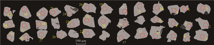
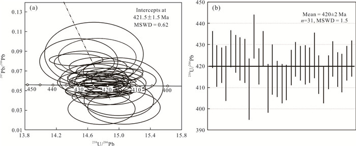
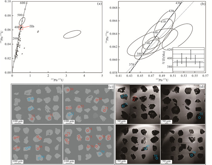
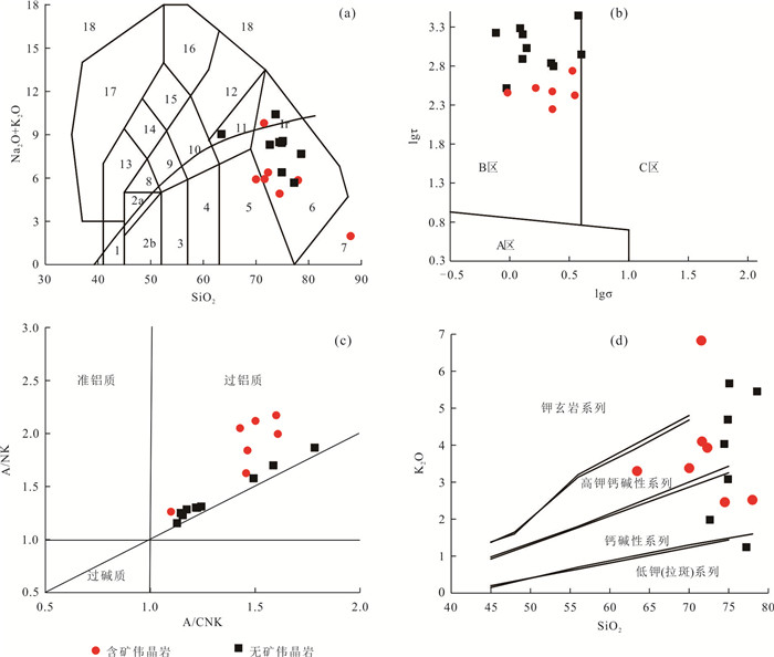
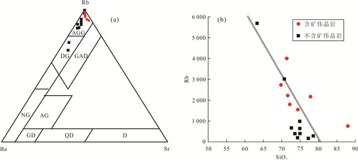
The Guanpo-Danfeng area in the North Qinling Belt is the most important pegmatite-type uranium metallogenic and an important pegmatite-type rare metal metallogenic region in China. However, the formation age and the genetic mechanism of the rare metal pegmatites in this area still remain unclear. This paper presents LA-MC-ICP-MS cassiterite U-Pb age, Hf isotopic and geochemical data of granitic pegmatites in the Guanpo area to determine the formation age, the petrogenesis and tectonic setting of the rare metal pegmatites. Cassiterite LA-MC-ICP-MS dating of Nanyangshan rare metal pegmatites yields concordant age of420±2 Ma, representing the the formation age of the end of the Silurian, which indicated North Qinling was in late or postorogenic tectonic setting.The pegmaties exhibit a restricted range of negative zircon εHf(t) values of -7.0 to -7.8, with TDM2 age of 2.45 to 2.52 Ga, suggesting that the magma dominantly derived from ancient crust. The pegmatites are characterized by high A/CNK (A/CNK > 1.1), with extremely low rare earth content (ΣREE=0.43×10⁻⁶~23.14×10⁻⁶) and widely variable LaN/YbN ratios(0.7~22.3) and δEu(0.09~1.84). The enrichment in large ion lithophile elements(Rb and K) and high field strength elements (Nb, Ta, P and Hf), depletion in Ba, Nd, Zr, and Ti, low Nb/Ta ratios (average 2.66) and tetrad effects of rare earth elements comprehensively indicated that the magma has experienced high degree crystallization differentiation. The isotopic and geochemical data confirm that the rare metal pegmatite in the Guanpo area formed from high degree crystallization differentiation of peraluminous granitic magma and the genetic connection between the pegmatites and Huichizi and Damaogou granites is absent.
The Guanpo-Danfeng area in the North Qinling Belt is the most important pegmatite-type uranium metallogenic and an important pegmatite-type rare metal metallogenic region in China. However, the formation age and the genetic mechanism of the rare metal pegmatites in this area still remain unclear. This paper presents LA-MC-ICP-MS cassiterite U-Pb age, Hf isotopic and geochemical data of granitic pegmatites in the Guanpo area to determine the formation age, the petrogenesis and tectonic setting of the rare metal pegmatites. Cassiterite LA-MC-ICP-MS dating of Nanyangshan rare metal pegmatites yields concordant age of420±2 Ma, representing the the formation age of the end of the Silurian, which indicated North Qinling was in late or postorogenic tectonic setting.The pegmaties exhibit a restricted range of negative zircon εHf(t) values of -7.0 to -7.8, with TDM2 age of 2.45 to 2.52 Ga, suggesting that the magma dominantly derived from ancient crust. The pegmatites are characterized by high A/CNK (A/CNK > 1.1), with extremely low rare earth content (ΣREE=0.43×10⁻⁶~23.14×10⁻⁶) and widely variable LaN/YbN ratios(0.7~22.3) and δEu(0.09~1.84). The enrichment in large ion lithophile elements(Rb and K) and high field strength elements (Nb, Ta, P and Hf), depletion in Ba, Nd, Zr, and Ti, low Nb/Ta ratios (average 2.66) and tetrad effects of rare earth elements comprehensively indicated that the magma has experienced high degree crystallization differentiation. The isotopic and geochemical data confirm that the rare metal pegmatite in the Guanpo area formed from high degree crystallization differentiation of peraluminous granitic magma and the genetic connection between the pegmatites and Huichizi and Damaogou granites is absent.


2023, 48(8): 2872-2887.
doi: 10.3799/dqkx.2021.219
Abstract:
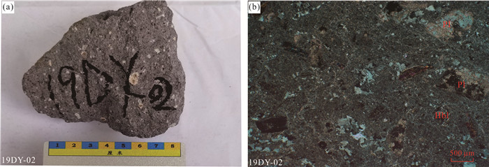
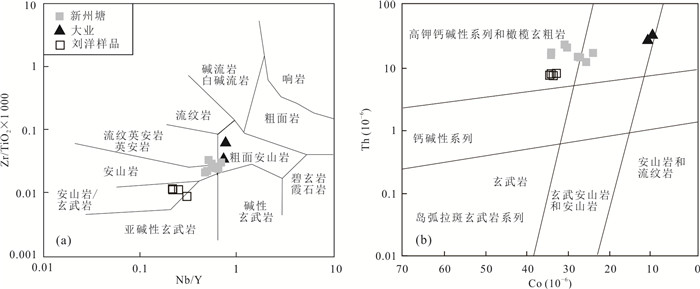
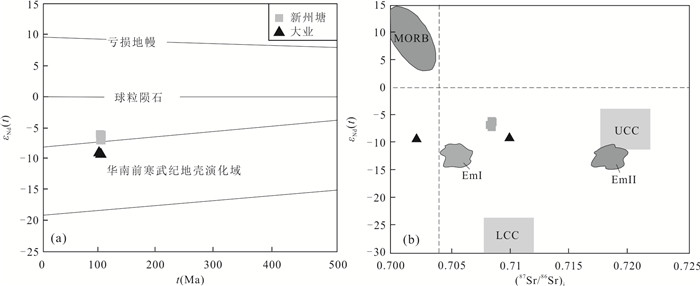
The late Mesozoic magmatism was widely developed in southeastern Guangxi, and its formation background and dynamic mechanism are still controversial. Chronological, whole-rock geochemistry and Sr-Nd-Hf isotope studies were carried out on the volcanic rocks in Xinzhoutang and Daye areas in southeast Guangxi. The results show that the main bodies of the Xinzhoutang and Daye volcanic rocks are andesite and dacite, respectively, and the zircon U-Pb ages are 98.5 to 100.5 Ma and 99.2 Ma, respectively, which were formed in the late Early Cretaceous. Both have the characteristics of low TiO2 (average value < 1%) and high Al2O3 (average value > 15%). They belong to the high potassium calcium-alkaline-potassium series. Both are enriched in LILE and depleted in HFSE, in the rare earth element distribution mode The above all showed the light rare earth enrichment right-leaning type, without obvious Eu anomaly. Compared with the Daye sample, the Xinzhoutang sample has a lower SiO2 content, a higher Mg# value, and a higher Cr and Ni content, It belongs to high magnesium andesite. The Sr-Nd-Hf isotope results show that the Xinzhou Tang andesite samples are more depleted than the Daye dacite samples (εNd(t) values are (-6.26~-7.11, -9.35~-9.37), εHf(t) values are (-6.47~-8.95, -8.70~-14.08)). Comprehensive regional data The Xinzhoutang andesite should be formed by partial melting of the enriched mantle, while the Daye dacite was formed by partial melting of the Paleoproterozoic crustal material during the same period. Their formation is closely related to the extensional structure of the South China continent in the Late Mesozoic.
The late Mesozoic magmatism was widely developed in southeastern Guangxi, and its formation background and dynamic mechanism are still controversial. Chronological, whole-rock geochemistry and Sr-Nd-Hf isotope studies were carried out on the volcanic rocks in Xinzhoutang and Daye areas in southeast Guangxi. The results show that the main bodies of the Xinzhoutang and Daye volcanic rocks are andesite and dacite, respectively, and the zircon U-Pb ages are 98.5 to 100.5 Ma and 99.2 Ma, respectively, which were formed in the late Early Cretaceous. Both have the characteristics of low TiO2 (average value < 1%) and high Al2O3 (average value > 15%). They belong to the high potassium calcium-alkaline-potassium series. Both are enriched in LILE and depleted in HFSE, in the rare earth element distribution mode The above all showed the light rare earth enrichment right-leaning type, without obvious Eu anomaly. Compared with the Daye sample, the Xinzhoutang sample has a lower SiO2 content, a higher Mg# value, and a higher Cr and Ni content, It belongs to high magnesium andesite. The Sr-Nd-Hf isotope results show that the Xinzhou Tang andesite samples are more depleted than the Daye dacite samples (εNd(t) values are (-6.26~-7.11, -9.35~-9.37), εHf(t) values are (-6.47~-8.95, -8.70~-14.08)). Comprehensive regional data The Xinzhoutang andesite should be formed by partial melting of the enriched mantle, while the Daye dacite was formed by partial melting of the Paleoproterozoic crustal material during the same period. Their formation is closely related to the extensional structure of the South China continent in the Late Mesozoic.


2023, 48(8): 2888-2904.
doi: 10.3799/dqkx.2021.210
Abstract:
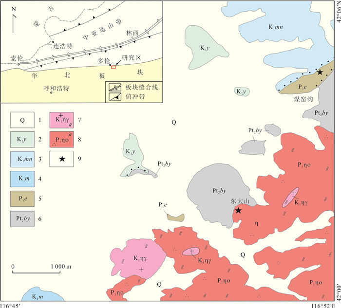
This paper presents petrological, Hf isotopes, geochronological and geochemical study on the early Permian Bimodal magmatites in Duolun area, Inner Mongolia, which is tectonically located in the northern margin of North China Craton, comprising quartz monzonite and basalt. U-Pb dating of zircons from the samples by LA-ICP-MS yield weighed mean 206Pb/238U ages of 283±1.6 Ma and 280±2.9 Ma respectively. They have similar Hf isotopes. Hf isotopes tDM2 was oldgenerally (from 1 760 to 2 354 Ma, merely two youngs: 324 Ma and 824 Ma) and closed to these reported in ancient basement of North China Plate. The quartz monzonite and basalt exhibit SiO2 geochemical discontinuity (50.64%~65.87%), showing typically bimodal features. They also significantly enrich K, Na, Al and deplete Ca, Mg. Besides, the quartz monzonite show significantly depletions in Ti and P compared with the basalt, showing complementary relations. This paper, combined with previous data, suggest that Bimodal magmatitesare the products of partial melting of the ancient basement of the North China Plate under the background of extension, which was caused by the upward migrating and gathering of the mantle magma formed from partial melting of mantle resulted in dewatering of subducted plate of the ancient Asian Ocean. In the early Permian, Dongdashan area is under the background of active continental margin.
This paper presents petrological, Hf isotopes, geochronological and geochemical study on the early Permian Bimodal magmatites in Duolun area, Inner Mongolia, which is tectonically located in the northern margin of North China Craton, comprising quartz monzonite and basalt. U-Pb dating of zircons from the samples by LA-ICP-MS yield weighed mean 206Pb/238U ages of 283±1.6 Ma and 280±2.9 Ma respectively. They have similar Hf isotopes. Hf isotopes tDM2 was oldgenerally (from 1 760 to 2 354 Ma, merely two youngs: 324 Ma and 824 Ma) and closed to these reported in ancient basement of North China Plate. The quartz monzonite and basalt exhibit SiO2 geochemical discontinuity (50.64%~65.87%), showing typically bimodal features. They also significantly enrich K, Na, Al and deplete Ca, Mg. Besides, the quartz monzonite show significantly depletions in Ti and P compared with the basalt, showing complementary relations. This paper, combined with previous data, suggest that Bimodal magmatitesare the products of partial melting of the ancient basement of the North China Plate under the background of extension, which was caused by the upward migrating and gathering of the mantle magma formed from partial melting of mantle resulted in dewatering of subducted plate of the ancient Asian Ocean. In the early Permian, Dongdashan area is under the background of active continental margin.


2023, 48(8): 2905-2914.
doi: 10.3799/dqkx.2022.055
Abstract:
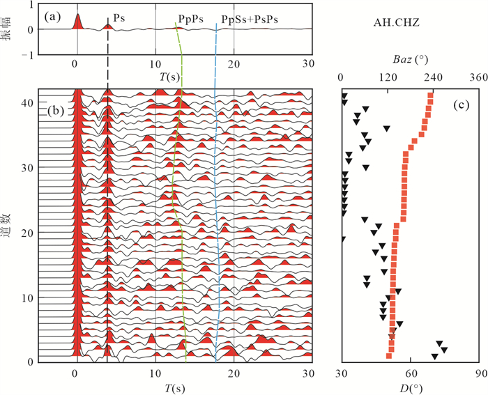
For the more thorough understanding of the crustal structure and evolution of Tanlu fault under extension background since early Cretaceous, we completed a study about crustal thickness and Poisson's ratio of Tanlu fault zone (southern segment) and adjacent Areas by P-wave receiver function. The results of H⁃κ showed the Lower Yangtze block's crust is relatively thinner and more severe deformation than the North China block's in study area. The average Poisson's ratio beneath Tanlu fault zone exhibited lower value feature. The result of migration revealed a crustal thinning deformation beneath the Tanlu fault zone, and a significant differences on thinning dip angle of Moho toward the Tanlu fault zone on both sides of the fault zone. Furthermore, The model of Asymmetrical extension could well explain the crustal evolution of southern segment of the Tanlu fault zone and its adjacent regions under extension background since early Cretaceous.
For the more thorough understanding of the crustal structure and evolution of Tanlu fault under extension background since early Cretaceous, we completed a study about crustal thickness and Poisson's ratio of Tanlu fault zone (southern segment) and adjacent Areas by P-wave receiver function. The results of H⁃κ showed the Lower Yangtze block's crust is relatively thinner and more severe deformation than the North China block's in study area. The average Poisson's ratio beneath Tanlu fault zone exhibited lower value feature. The result of migration revealed a crustal thinning deformation beneath the Tanlu fault zone, and a significant differences on thinning dip angle of Moho toward the Tanlu fault zone on both sides of the fault zone. Furthermore, The model of Asymmetrical extension could well explain the crustal evolution of southern segment of the Tanlu fault zone and its adjacent regions under extension background since early Cretaceous.


2023, 48(8): 2915-2932.
doi: 10.3799/dqkx.2023.049
Abstract:
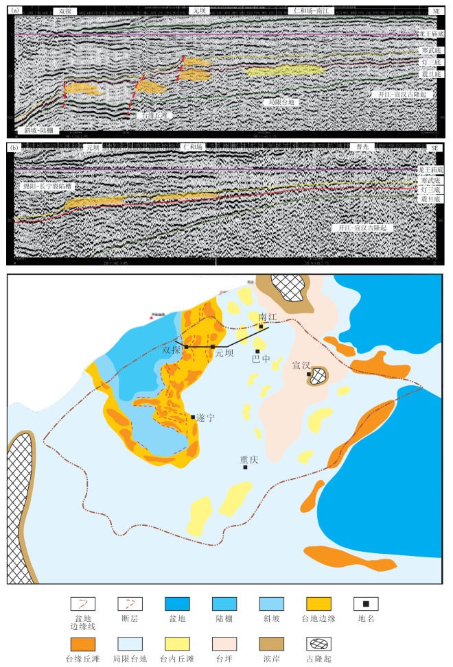
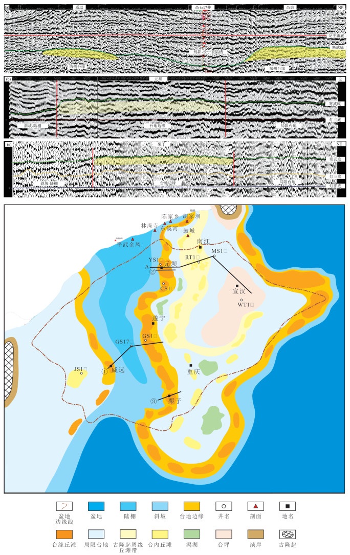
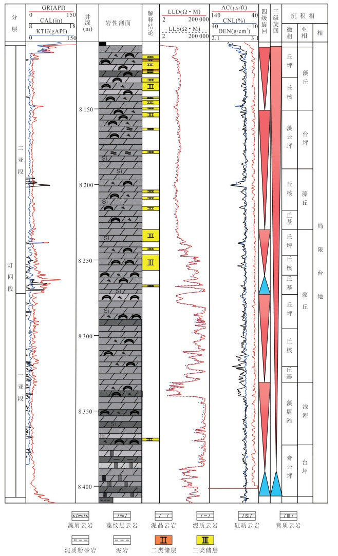
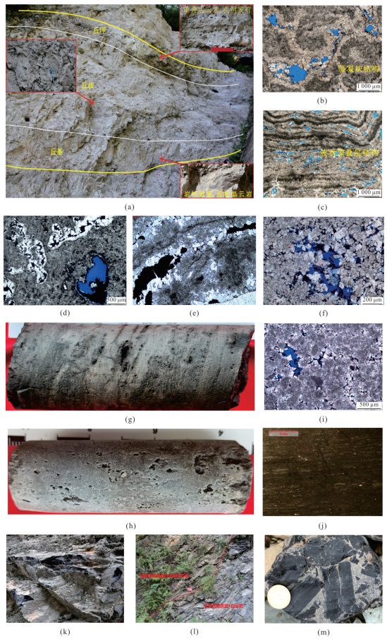
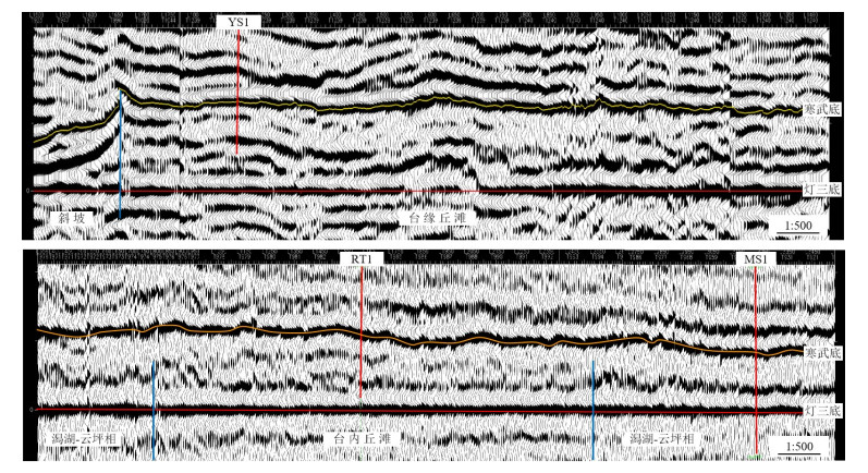
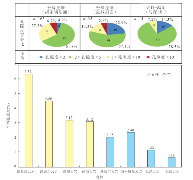
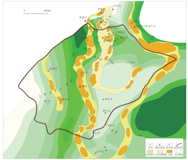
There are many divergences on the sedimentary pattern and reservoir development types of of the Sinian Dengying Formation in Sichuan Basin. In order to provide support for oil and gas exploration of Dengying Formation in the basin, the sedimentary pattern and multi type reservoir development characteristics of Dengying Formation are studied by using the field profile, drilling and seismic data. The controlling factors of high⁃quality reservoir development are defined, and the favorable areas for exploration breakthrough are pointed out. This study indicated that (1) Controlled by Mianyang⁃Changning rift trough, Hannan ancient land and Kaijiang⁃Xuanhan ancient uplift, Dengying Formation developed four favorable facies which are mound beach on the platform edge and mound beach in the platform. (2) The development of favorable dune and shoal facies belt in the fourth member of Dengying Formation is controlled by uplift depression pattern. Distribution of dune shoal facies belt on the console margin of rift trough. The platform margin facies area in the east is distributed in the Nanjiang⁃Yuanba⁃Gaomo⁃Lizi area. The platform margin facies area in the west is distributed in the Weiyuan⁃Chengdu⁃Dujiangyan area. The surrounding area of underwater paleo uplift and local micro geomorphic highland are favorable for the large⁃scale distribution of hills and beaches in the platform. (3) The reservoir of the fourth member of Dengying Formation is mainly developed in the platform margin mound bank reservoir and the shaol reformed reservoir. The development of high⁃quality reservoirs is jointly controlled by high⁃energy facies belt, quasi syngenetic period and Tongwan period karst transformation. There are three favorable exploration areas in the fourth member of Dengying Formation in Sichuan Basin: Yuanba⁃Langzhong Dengying Formation platform margin, Western Sichuan⁃Lizi Dengying Formation platform margin and Tongnanba⁃Puguang⁃Qijiang Dengying Formation platform. The three exploration areas are the important strategic new zones of oil and gas breakthrough in the deep ultra deep exploration field of the fourth member of Dengying Formation
There are many divergences on the sedimentary pattern and reservoir development types of of the Sinian Dengying Formation in Sichuan Basin. In order to provide support for oil and gas exploration of Dengying Formation in the basin, the sedimentary pattern and multi type reservoir development characteristics of Dengying Formation are studied by using the field profile, drilling and seismic data. The controlling factors of high⁃quality reservoir development are defined, and the favorable areas for exploration breakthrough are pointed out. This study indicated that (1) Controlled by Mianyang⁃Changning rift trough, Hannan ancient land and Kaijiang⁃Xuanhan ancient uplift, Dengying Formation developed four favorable facies which are mound beach on the platform edge and mound beach in the platform. (2) The development of favorable dune and shoal facies belt in the fourth member of Dengying Formation is controlled by uplift depression pattern. Distribution of dune shoal facies belt on the console margin of rift trough. The platform margin facies area in the east is distributed in the Nanjiang⁃Yuanba⁃Gaomo⁃Lizi area. The platform margin facies area in the west is distributed in the Weiyuan⁃Chengdu⁃Dujiangyan area. The surrounding area of underwater paleo uplift and local micro geomorphic highland are favorable for the large⁃scale distribution of hills and beaches in the platform. (3) The reservoir of the fourth member of Dengying Formation is mainly developed in the platform margin mound bank reservoir and the shaol reformed reservoir. The development of high⁃quality reservoirs is jointly controlled by high⁃energy facies belt, quasi syngenetic period and Tongwan period karst transformation. There are three favorable exploration areas in the fourth member of Dengying Formation in Sichuan Basin: Yuanba⁃Langzhong Dengying Formation platform margin, Western Sichuan⁃Lizi Dengying Formation platform margin and Tongnanba⁃Puguang⁃Qijiang Dengying Formation platform. The three exploration areas are the important strategic new zones of oil and gas breakthrough in the deep ultra deep exploration field of the fourth member of Dengying Formation


2023, 48(8): 2933-2946.
doi: 10.3799/dqkx.2023.057
Abstract:
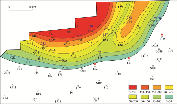
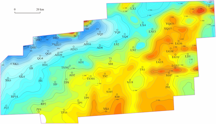
It is of great significance to quantitatively restore eroded strata for tectonic study in a basin. In this paper, through spectral analysis of the ln (Th/K) curve, an indicator of climate variation resulting from Milankovitch cycles, the eroded strata of Ordovician Yijianfang and Yingshan formations are quantitatively restored on Lunnan paleo⁃uplift of Tarim Basin. The following three results are concluded: (1)Milankovitch cycles are characterized by undeveloped longer eccentricity period (413 ka, 125 ka), well developed short eccentricity period of 95 ka, slope period and precession period in Yijianfang and Yingshan formations. (2) There are 86 short eccentricity periods developed in Yijianfang and Yingshan formations. Erosion thicknesses in 8 wells are restored quantitively by comparing the amount of Milankovitch cycles in short eccentricity period in denudation zones and inside strata. (3)Distributed in the north of well zone H6⁃TS2⁃TS1⁃LG36, the denudation zones include northwestern and northern centers, with an erosion thickness of over 300 m and 250 m respectively. It is approved that Milankovitch cycle analysis is a proxy for quantitative restoration of eroded carbonate strata and provide insight for paleo⁃structures restoration in marine carbonate basins.
It is of great significance to quantitatively restore eroded strata for tectonic study in a basin. In this paper, through spectral analysis of the ln (Th/K) curve, an indicator of climate variation resulting from Milankovitch cycles, the eroded strata of Ordovician Yijianfang and Yingshan formations are quantitatively restored on Lunnan paleo⁃uplift of Tarim Basin. The following three results are concluded: (1)Milankovitch cycles are characterized by undeveloped longer eccentricity period (413 ka, 125 ka), well developed short eccentricity period of 95 ka, slope period and precession period in Yijianfang and Yingshan formations. (2) There are 86 short eccentricity periods developed in Yijianfang and Yingshan formations. Erosion thicknesses in 8 wells are restored quantitively by comparing the amount of Milankovitch cycles in short eccentricity period in denudation zones and inside strata. (3)Distributed in the north of well zone H6⁃TS2⁃TS1⁃LG36, the denudation zones include northwestern and northern centers, with an erosion thickness of over 300 m and 250 m respectively. It is approved that Milankovitch cycle analysis is a proxy for quantitative restoration of eroded carbonate strata and provide insight for paleo⁃structures restoration in marine carbonate basins.


2023, 48(8): 2947-2959.
doi: 10.3799/dqkx.2022.377
Abstract:
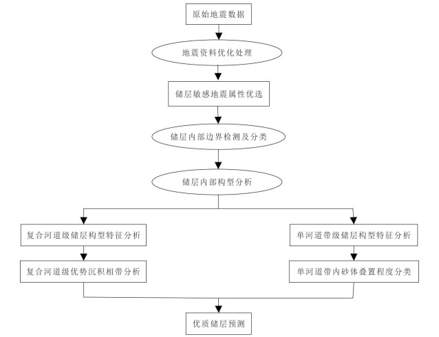
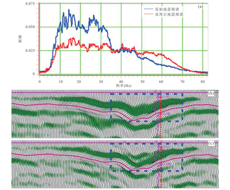
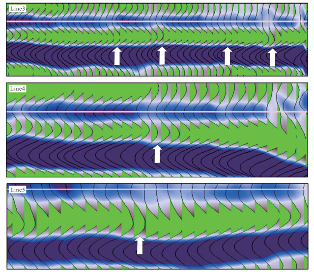
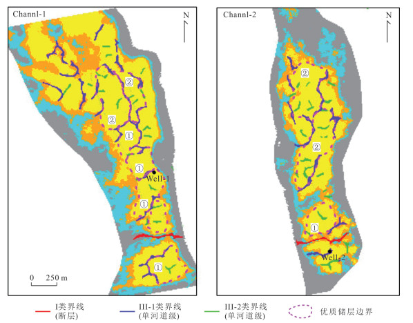
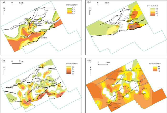
Underwater distributary channel sand body of fan deltaic front, the main reservoir for L1V oil group in K oil field, characterized by thin sand body, strong heterogeneity, low porosity and low permeability. At present, there are some problems in the oilfield development and production, such as slow diffusion of injected water and difficulty in energy supplement, unclear effectiveness of some water injection in some blocks, and limited scope of water flooding and so on. It's difficult to solve these problems just based on traditional Predominant sedimentary facies anlysis, especially to the low permeability reservoir. In this paper, one method was proposed to predict relatively high quality distribution in low permeability reservoirs dominated by different levels of architecture. Firstly, Based on optimized seismic data, the internal reservoir architecture boundaries are detected and classified, adopting mathematical morphology analysis method. Besides, different levels of reservoir architecture are analyzed in L1V oil formation. Secondly, constrained by composite channel reservoir architecture analysis, the distribution of dominant sedimentary facies belt for Channl⁃1 and Channel⁃2 are researched in L1V oil group, applying neural network clustering method. Finally, combined with dominant sedimentary facies belt and channel architecture boundary, which characterizes the connectivity of single stage channel sand body, relatively high quality reservoirs for low permeability reservoirs in the study area are optimized. The result shows that 1) for L1V oil formation, reservoir architecture boundaries are divided into 3 categories and 5 subcategories, including fault, composite channel and single channel belt, with different characteristics in sand body connectivity and seismic reflection; 2) it develops three composite channel in L1V oil formation, including Channel⁃1, Channel⁃2, Channel⁃3 with near N⁃S trending. Besides, sedimentary microfacies for each composite channel includes underwater distributary channel, inter⁃channel and levee. Among them, fan delta front underwater distributary channel is a high⁃quality reservoir facies belt with pretty porosity and permeability; 3) Based on the dominant sedimentary facies belt, combined with the reservoir architecture boundary characteristics, high⁃quality reservoirs for composite channel in the L1V oil group can be divided into two types. The method in this paper can improve the prediction accuracy of high quality reservoir in low⁃permeability reservoirs and guide inter well sand body connectivity and remaining oil potential area analysis. That will be beneficial to effectively avoid development risk in the oilfield development comprehensive adjustment stage and improve the economic benefits.
Underwater distributary channel sand body of fan deltaic front, the main reservoir for L1V oil group in K oil field, characterized by thin sand body, strong heterogeneity, low porosity and low permeability. At present, there are some problems in the oilfield development and production, such as slow diffusion of injected water and difficulty in energy supplement, unclear effectiveness of some water injection in some blocks, and limited scope of water flooding and so on. It's difficult to solve these problems just based on traditional Predominant sedimentary facies anlysis, especially to the low permeability reservoir. In this paper, one method was proposed to predict relatively high quality distribution in low permeability reservoirs dominated by different levels of architecture. Firstly, Based on optimized seismic data, the internal reservoir architecture boundaries are detected and classified, adopting mathematical morphology analysis method. Besides, different levels of reservoir architecture are analyzed in L1V oil formation. Secondly, constrained by composite channel reservoir architecture analysis, the distribution of dominant sedimentary facies belt for Channl⁃1 and Channel⁃2 are researched in L1V oil group, applying neural network clustering method. Finally, combined with dominant sedimentary facies belt and channel architecture boundary, which characterizes the connectivity of single stage channel sand body, relatively high quality reservoirs for low permeability reservoirs in the study area are optimized. The result shows that 1) for L1V oil formation, reservoir architecture boundaries are divided into 3 categories and 5 subcategories, including fault, composite channel and single channel belt, with different characteristics in sand body connectivity and seismic reflection; 2) it develops three composite channel in L1V oil formation, including Channel⁃1, Channel⁃2, Channel⁃3 with near N⁃S trending. Besides, sedimentary microfacies for each composite channel includes underwater distributary channel, inter⁃channel and levee. Among them, fan delta front underwater distributary channel is a high⁃quality reservoir facies belt with pretty porosity and permeability; 3) Based on the dominant sedimentary facies belt, combined with the reservoir architecture boundary characteristics, high⁃quality reservoirs for composite channel in the L1V oil group can be divided into two types. The method in this paper can improve the prediction accuracy of high quality reservoir in low⁃permeability reservoirs and guide inter well sand body connectivity and remaining oil potential area analysis. That will be beneficial to effectively avoid development risk in the oilfield development comprehensive adjustment stage and improve the economic benefits.


2023, 48(8): 2960-2978.
doi: 10.3799/dqkx.2023.032
Abstract:
In view of the large difference in productivity test results between low⁃permeability glutenite pay zone and sandstone pay zones, taking the low⁃permeability glutenite reservoir of Liushagang Formation in Wushi Sag of Beibu Gulf Basin as the main research object, the research on microscopic pore structure, microscopic seepage capacity, microscopic seepage characteristics and strategies for improving water flooding effect to enhance oil recovery was carried out through the indoor core experiments. The results show that the low⁃permeability glutenite reservoir has the characteristics of ternary pore structure, and the large pore throat and micro pore throat are more developed, resulting in the seepage characteristics of "high gas permeability, low liquid permeability, and low oil displacement efficiency" and the post⁃displacement fluid microscopic distribution characteristics of "large pore throat is rich in injection water, medium throat is rich in remaining oil, and micro pore throat is rich in original bound water". The key to improve the recovery factor of low permeability glutenite reservoir is to improve the microscopic sweep coefficient to increase the utilization rate of medium pore throat crude oil. It is suggested to change wettability by injecting low valent and high salinity water and utilize imbibition role by unsteady water injection to improve water flooding effect and enhance oil recovery.
In view of the large difference in productivity test results between low⁃permeability glutenite pay zone and sandstone pay zones, taking the low⁃permeability glutenite reservoir of Liushagang Formation in Wushi Sag of Beibu Gulf Basin as the main research object, the research on microscopic pore structure, microscopic seepage capacity, microscopic seepage characteristics and strategies for improving water flooding effect to enhance oil recovery was carried out through the indoor core experiments. The results show that the low⁃permeability glutenite reservoir has the characteristics of ternary pore structure, and the large pore throat and micro pore throat are more developed, resulting in the seepage characteristics of "high gas permeability, low liquid permeability, and low oil displacement efficiency" and the post⁃displacement fluid microscopic distribution characteristics of "large pore throat is rich in injection water, medium throat is rich in remaining oil, and micro pore throat is rich in original bound water". The key to improve the recovery factor of low permeability glutenite reservoir is to improve the microscopic sweep coefficient to increase the utilization rate of medium pore throat crude oil. It is suggested to change wettability by injecting low valent and high salinity water and utilize imbibition role by unsteady water injection to improve water flooding effect and enhance oil recovery.


2023, 48(8): 2979-2992.
doi: 10.3799/dqkx.2023.020
Abstract:
In order to clarify the genetic types, controlling factors and distribution rules of sandbodies in the third member of Dongying Formation of the west slope in the south-central Liaozhong Sag, combining drilling logs, analytical tests and 3D seismic data, the characteristics of sandbodies sedimentary response were analyzed, and its controlling factors and development patterns were discussed, the plane distribution and vertical evolution characteristics of gravity flow under high-precision sequence framework were clarified by means of well seismic calibration, stratum slicing and attribute extraction. The results show that the sandbodies in the third member of Dongying Formation of the study area were sublacustrine fan deposits, which have unique sedimentary characteristics of gravity flow on the grain size curve and C-M map. The sedimentary structure was dominated by massive sandstone, with local gravity flow characteristics such as boulders, mudstone lacerations, corrugated bedding and parallel bedding. There are two kinds of seismic phase characteristics: strong amplitude reflection of a single in-phase axis, low frequency of medium and weak amplitude, and certain configuration. The sublacustrine fan sandbodies were mainly controlled by the source supply outside the basin, the slope break zone and the secondary lake flood surface. Among them, The large braided river delta formed from the source outside the western Yanshan, which crossed the Liaoxi low uplift of "chain island" type, provided the material basis for sublacustrine fan deposition. the development location and facies zone boundary of sublacustrine fan were controled by the sedimentary slope breaks. The forward and reverse fault slope breaks in the basin can redistribute and regulate the distribution and flow direction of sand bodies, and further control the plane distribution morphology and development degree of sublacustrine fan sandbodies. The secondary flood surface formed by the frequent fluctuation of the lake plane controlled the vertical multi-phase superposition of sublacustrine fan, and the flood mudstone provided a good preservation condition for the lateral occlusion of the slope zone. The three-factor dynamic equilibrium sublacustrine fan sedimentation model controled the development of large-area lithologic traps in the slope area. sublacustrine fan are mainly distributed in the trangressive system tract of in the third member of Dongying sequence, a small amount of sublacustrine fan are developed in the lowstand system tract and highstand system tract. In the plane, the sublacustrine fan in the B structure area is tongue like, and its development scale and distribution range are better than those in the A and C structure areas, and the vertical overlap is good, and the oil and gas accumulation conditions are superior, which is a favorable target for the next exploration and evaluation of lithologic reservoirs.
In order to clarify the genetic types, controlling factors and distribution rules of sandbodies in the third member of Dongying Formation of the west slope in the south-central Liaozhong Sag, combining drilling logs, analytical tests and 3D seismic data, the characteristics of sandbodies sedimentary response were analyzed, and its controlling factors and development patterns were discussed, the plane distribution and vertical evolution characteristics of gravity flow under high-precision sequence framework were clarified by means of well seismic calibration, stratum slicing and attribute extraction. The results show that the sandbodies in the third member of Dongying Formation of the study area were sublacustrine fan deposits, which have unique sedimentary characteristics of gravity flow on the grain size curve and C-M map. The sedimentary structure was dominated by massive sandstone, with local gravity flow characteristics such as boulders, mudstone lacerations, corrugated bedding and parallel bedding. There are two kinds of seismic phase characteristics: strong amplitude reflection of a single in-phase axis, low frequency of medium and weak amplitude, and certain configuration. The sublacustrine fan sandbodies were mainly controlled by the source supply outside the basin, the slope break zone and the secondary lake flood surface. Among them, The large braided river delta formed from the source outside the western Yanshan, which crossed the Liaoxi low uplift of "chain island" type, provided the material basis for sublacustrine fan deposition. the development location and facies zone boundary of sublacustrine fan were controled by the sedimentary slope breaks. The forward and reverse fault slope breaks in the basin can redistribute and regulate the distribution and flow direction of sand bodies, and further control the plane distribution morphology and development degree of sublacustrine fan sandbodies. The secondary flood surface formed by the frequent fluctuation of the lake plane controlled the vertical multi-phase superposition of sublacustrine fan, and the flood mudstone provided a good preservation condition for the lateral occlusion of the slope zone. The three-factor dynamic equilibrium sublacustrine fan sedimentation model controled the development of large-area lithologic traps in the slope area. sublacustrine fan are mainly distributed in the trangressive system tract of in the third member of Dongying sequence, a small amount of sublacustrine fan are developed in the lowstand system tract and highstand system tract. In the plane, the sublacustrine fan in the B structure area is tongue like, and its development scale and distribution range are better than those in the A and C structure areas, and the vertical overlap is good, and the oil and gas accumulation conditions are superior, which is a favorable target for the next exploration and evaluation of lithologic reservoirs.


2023, 48(8): 2993-3006.
doi: 10.3799/dqkx.2022.417
Abstract:
Because of its geothermal, mineral, and oil and gas resources, volcanic rock reservoirs have piqued the interest of scholars from all over the world. Shear-wave velocity is crucial for seismic AVO analysis, reservoir characterization, and fluid identification. Shear wave velocity information is often missing in logging data due to limitations in acquisition technology and acquisition cost.Based on the statistical petrophysical inversion method and Xu-White model, this paper proposes a S-wave velocity prediction method of statistical rock-physics model suitable for volcanic reservoirs. This method uses the P-wave and S-wave velocity of sand and the aspect ratio of clay-related pores in the Xu-White model as the key petrophysical parameters affecting rock velocity. Firstly, according to the statistical rock physical inversion method, the prior distribution of key petrophysical parameters is constructed by the conventional logging data of reference wells and the Xu-White model. Secondly, the prior distribution is used to initialize the Xu-White model instead of the fixed parameter value to establish the statistical rock-physics model. Thirdly, based on the Bayesian inversion theory, the actual P-wave velocity and the simulated P-wave velocity of the target well are matched to calculate the posterior information of key petrophysical parameters of the target well. Finally, the S-wave velocity information of the target well is inversed by using the statistical rock-physics model and the posterior distribution of key petrophysical parameters of the target well. This method is applied to the actual logging data of No. 5 structure in Nanpu Sag, eastern China, and the S-wave velocity prediction results are better than those of the conventional method, which proves the effectiveness and accuracy of this method. This study will provide more accurate S-wave velocity for the subsequent exploration and development of volcanic reservoirs.
Because of its geothermal, mineral, and oil and gas resources, volcanic rock reservoirs have piqued the interest of scholars from all over the world. Shear-wave velocity is crucial for seismic AVO analysis, reservoir characterization, and fluid identification. Shear wave velocity information is often missing in logging data due to limitations in acquisition technology and acquisition cost.Based on the statistical petrophysical inversion method and Xu-White model, this paper proposes a S-wave velocity prediction method of statistical rock-physics model suitable for volcanic reservoirs. This method uses the P-wave and S-wave velocity of sand and the aspect ratio of clay-related pores in the Xu-White model as the key petrophysical parameters affecting rock velocity. Firstly, according to the statistical rock physical inversion method, the prior distribution of key petrophysical parameters is constructed by the conventional logging data of reference wells and the Xu-White model. Secondly, the prior distribution is used to initialize the Xu-White model instead of the fixed parameter value to establish the statistical rock-physics model. Thirdly, based on the Bayesian inversion theory, the actual P-wave velocity and the simulated P-wave velocity of the target well are matched to calculate the posterior information of key petrophysical parameters of the target well. Finally, the S-wave velocity information of the target well is inversed by using the statistical rock-physics model and the posterior distribution of key petrophysical parameters of the target well. This method is applied to the actual logging data of No. 5 structure in Nanpu Sag, eastern China, and the S-wave velocity prediction results are better than those of the conventional method, which proves the effectiveness and accuracy of this method. This study will provide more accurate S-wave velocity for the subsequent exploration and development of volcanic reservoirs.


2023, 48(8): 3007-3020.
doi: 10.3799/dqkx.2023.131
Abstract:
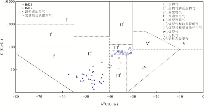
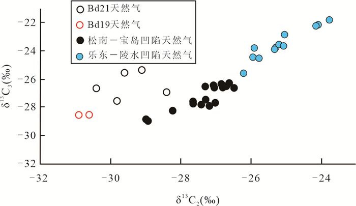
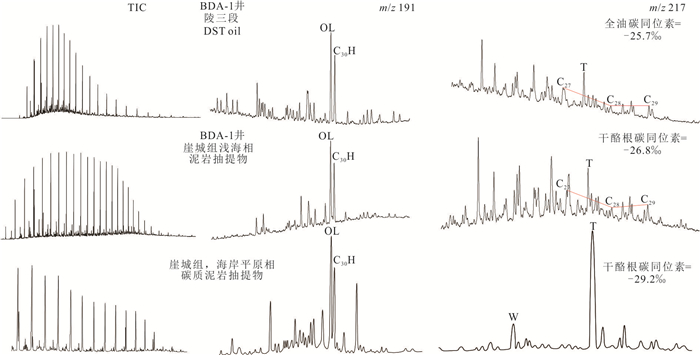
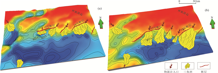
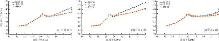
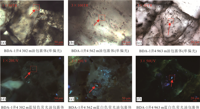
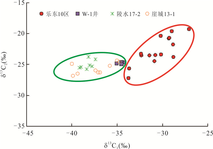
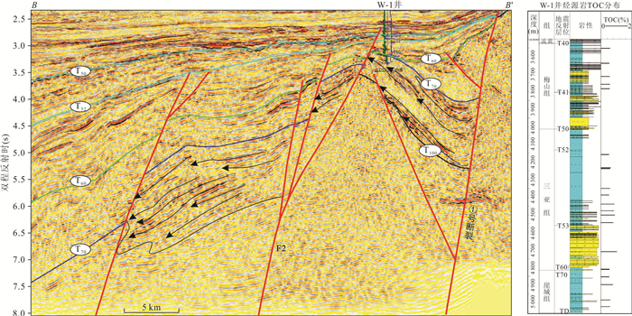
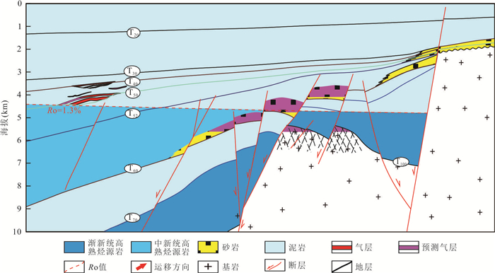
A number of gas-bearing structures were discovered in the northern fault zone of Songnan-Baodao Sag in Qiongdongnan Basin, but great disputes on the understanding of hydrocarbon source in the northern fault zone, the research on the scale of source rocks in deep-water is still weak, which hindered the decision of the next exploration direction. A total of 84 mudstone, 7 natrual gases, 3 crudoil samples from the study area were collected for rock pyrolysis, kerrogen carbon isotope, biomarkers, light hydrocarbon and carbon isotope analysis of natural gas in this paper, Geochemical characteristics of source rock from different strata in the study area systematic comparison, it is believed that the oil and gas in the norhern fault-step zone of Songnan-Baodao depression derived from marine mudstone of yacheng formation, and land-based organic hydrocarbon generation is dominant, combined with the paleoenvironment paleontology and microscopic components analysis, it is predicted that the whole yacheng formation is a shallow sea sedimentary environment, and conductive to the enrichment of organic matter form good source rocks, On this basis, the distribution characteristics of hydrocarbon source rocks of the yacheng formation in the study area are clarified through the seismic facies. The results show that the yacheng formation in the study area develop a large-scale coal-bearing delta、marine sedimentary system, which is the main occurrence unit of good hydrocarbon source rocks, distributed along the near concave and fault step zone. Fluid inclusion evidence shows that there are at least two stages of hydrocarbon filling in the deep-water area of the northern fault step zone of Songnan-Baodao depression, and the main accumulation is the high mature coal-type gas. It is confirmed that source rocks deposited on the coal-bearing delta and marine facies have rich gas supply, and a large amount of natural gas will be easier generated in the later stage, it is speculated that there are similar source rock distribution, thermal evolution characteristics and transport system in the fault step zone of deep-water area on the east side, which should be the first choice for next natural gas exploration.
A number of gas-bearing structures were discovered in the northern fault zone of Songnan-Baodao Sag in Qiongdongnan Basin, but great disputes on the understanding of hydrocarbon source in the northern fault zone, the research on the scale of source rocks in deep-water is still weak, which hindered the decision of the next exploration direction. A total of 84 mudstone, 7 natrual gases, 3 crudoil samples from the study area were collected for rock pyrolysis, kerrogen carbon isotope, biomarkers, light hydrocarbon and carbon isotope analysis of natural gas in this paper, Geochemical characteristics of source rock from different strata in the study area systematic comparison, it is believed that the oil and gas in the norhern fault-step zone of Songnan-Baodao depression derived from marine mudstone of yacheng formation, and land-based organic hydrocarbon generation is dominant, combined with the paleoenvironment paleontology and microscopic components analysis, it is predicted that the whole yacheng formation is a shallow sea sedimentary environment, and conductive to the enrichment of organic matter form good source rocks, On this basis, the distribution characteristics of hydrocarbon source rocks of the yacheng formation in the study area are clarified through the seismic facies. The results show that the yacheng formation in the study area develop a large-scale coal-bearing delta、marine sedimentary system, which is the main occurrence unit of good hydrocarbon source rocks, distributed along the near concave and fault step zone. Fluid inclusion evidence shows that there are at least two stages of hydrocarbon filling in the deep-water area of the northern fault step zone of Songnan-Baodao depression, and the main accumulation is the high mature coal-type gas. It is confirmed that source rocks deposited on the coal-bearing delta and marine facies have rich gas supply, and a large amount of natural gas will be easier generated in the later stage, it is speculated that there are similar source rock distribution, thermal evolution characteristics and transport system in the fault step zone of deep-water area on the east side, which should be the first choice for next natural gas exploration.


2023, 48(8): 3021-3030.
doi: 10.3799/dqkx.2022.479
Abstract:
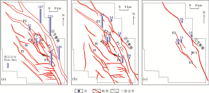
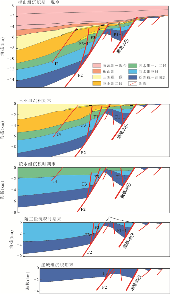
The purpose of this paper lies in clarifying the characteristics of faults in middle-deep layers in the southern segment of the eastern belt of Yinggehai Basin and their controlling effect on natural gas accumulation. Based on the new 3D seismic data, the faults in middle-deep layers in the southern segment of the eastern belt of Yinggehai Basin are described precisely for the first time. Combined with the characteristics of regional tectonic evolution, the types, shapes and activities of the faults are analyzed, and the controlling effect of the faults on natural gas accumulation is discussed. The results show that the Eocene-Early Miocene Yinggehai Basin is in the tectonic deformation stress field caused by left strike-slip. Located in the strike-slip transition zone of the No. 1 fault, the southern segment of the eastern belt of Yinggehai Basin develops three groups of tension-torsion (partialcompression-torsion) strike-slip faults. On the plane, the faults are NW-SE trending, with a left-lateral and right-step distribution. On the section, three groups of the faults are steep in occurrence, and present fault-step-like style and flower-like structures locally. The faults are mainly active in three phases: (1)Eocene-Early Oligocene, (2)Early and Mid-Late Oligocene, (3)Early Miocene, characterized by "early faults early senescence". The multi-stage activities of the faults in middle-deep layers control the development of land source deltas and hydrocarbon sources in the Yacheng Formation, the formulation of the "second step" gas accumulation background, the spatial distribution of sandstone in the Sanya Formation and the formation of traps. With a good match of production, migration and accumulation, the middle-deep layer in the southern section of the eastern belt of Yinggehai Basin is expected to become a natural gas accumulation area of 100 billion cubic meters in the Yinggehai Basin.
The purpose of this paper lies in clarifying the characteristics of faults in middle-deep layers in the southern segment of the eastern belt of Yinggehai Basin and their controlling effect on natural gas accumulation. Based on the new 3D seismic data, the faults in middle-deep layers in the southern segment of the eastern belt of Yinggehai Basin are described precisely for the first time. Combined with the characteristics of regional tectonic evolution, the types, shapes and activities of the faults are analyzed, and the controlling effect of the faults on natural gas accumulation is discussed. The results show that the Eocene-Early Miocene Yinggehai Basin is in the tectonic deformation stress field caused by left strike-slip. Located in the strike-slip transition zone of the No. 1 fault, the southern segment of the eastern belt of Yinggehai Basin develops three groups of tension-torsion (partialcompression-torsion) strike-slip faults. On the plane, the faults are NW-SE trending, with a left-lateral and right-step distribution. On the section, three groups of the faults are steep in occurrence, and present fault-step-like style and flower-like structures locally. The faults are mainly active in three phases: (1)Eocene-Early Oligocene, (2)Early and Mid-Late Oligocene, (3)Early Miocene, characterized by "early faults early senescence". The multi-stage activities of the faults in middle-deep layers control the development of land source deltas and hydrocarbon sources in the Yacheng Formation, the formulation of the "second step" gas accumulation background, the spatial distribution of sandstone in the Sanya Formation and the formation of traps. With a good match of production, migration and accumulation, the middle-deep layer in the southern section of the eastern belt of Yinggehai Basin is expected to become a natural gas accumulation area of 100 billion cubic meters in the Yinggehai Basin.


2023, 48(8): 3031-3043.
doi: 10.3799/dqkx.2022.459
Abstract:
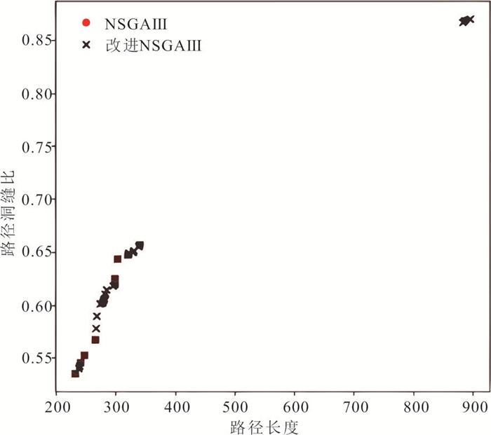
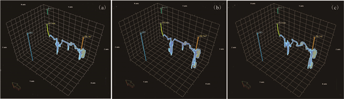
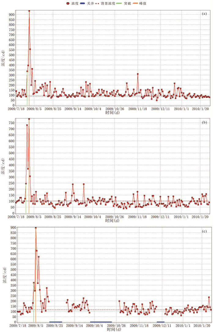
The deep marine carbonate reservoirs have complex reservoir types and strong heterogeneity, so it's difficult to evaluate the well connectivity.This paper designs a three-layer structure to address the subjectivity and multiple solutions problems about traditional static and dynamic inter-well connected evaluation methods. The improved A* algorithm is proposed to search for the inter-well connected paths by geological formations. The improved NSGA Ⅲ algorithm with self-applicable cross-variance probability according to the optimization objective is proposed to obtain three-dimensional multi-connected paths automatically which can carefully characterize the static connectivity. The experiment takes the S80 unit typical well group as the object in the TAHE oilfield. The results show that the adaptive cross-variance probability can effectively improve the multi-objective algorithm global search capability. The automatic search paths match with the seismic multi-attribute data analysis and tracer testing.Therefore, the algorithm can better reflect the spatial configuration relationship of fractures and cavities at different scales between wells. Furthermore, it can also provide technical support for adjusting the work system and improving the recovery in the field development of fractured-vuggy reservoirs in the water-injecting development stage.
The deep marine carbonate reservoirs have complex reservoir types and strong heterogeneity, so it's difficult to evaluate the well connectivity.This paper designs a three-layer structure to address the subjectivity and multiple solutions problems about traditional static and dynamic inter-well connected evaluation methods. The improved A* algorithm is proposed to search for the inter-well connected paths by geological formations. The improved NSGA Ⅲ algorithm with self-applicable cross-variance probability according to the optimization objective is proposed to obtain three-dimensional multi-connected paths automatically which can carefully characterize the static connectivity. The experiment takes the S80 unit typical well group as the object in the TAHE oilfield. The results show that the adaptive cross-variance probability can effectively improve the multi-objective algorithm global search capability. The automatic search paths match with the seismic multi-attribute data analysis and tracer testing.Therefore, the algorithm can better reflect the spatial configuration relationship of fractures and cavities at different scales between wells. Furthermore, it can also provide technical support for adjusting the work system and improving the recovery in the field development of fractured-vuggy reservoirs in the water-injecting development stage.


2023, 48(8): 3044-3052.
doi: 10.3799/dqkx.2022.276
Abstract:
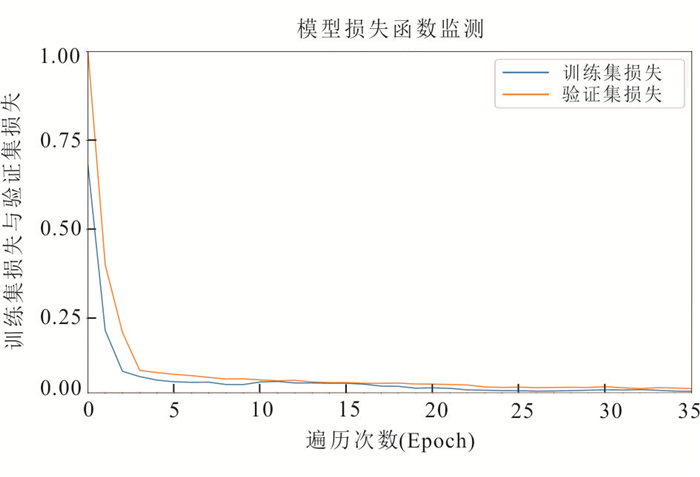
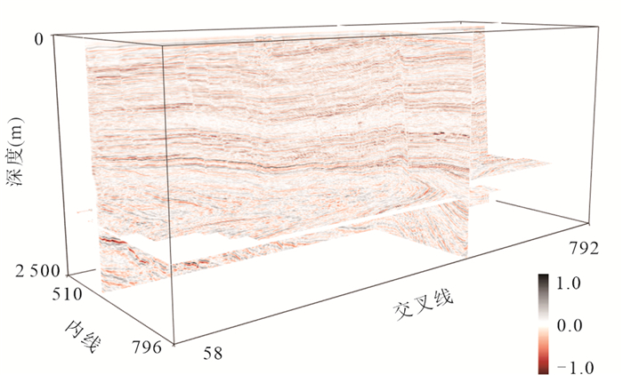
Fine fault identification is of great significance to improve the efficiency of exploration and development. Traditional seismic attribute fault recognition technologies identify fractures based on data discontinuity, and there are many interfering factors, making it more and more difficult to meet the needs of fine exploration in deep area. In order to improve the fault identification accuracy, this paper proposes a high-resolution intelligent identification method of fault. Based on the deep learning method to predict fault attributes from seismic data, a high-resolution and low-resolution fault label library is established, and a deep neural network is trained. It is confirmed by the model and actual data that the method solves the problem of high-frequency loss caused by up sampling in the convolutional neural network in deep learning, which reduces the resolution of faults, and improves the resolution ability. The root mean square error of the simulated data decreased by 40.02%.Compared with traditional algorithms, the method not only detects fault features more accurately, but also has a higher resolution than common deep learning fault recognition.
Fine fault identification is of great significance to improve the efficiency of exploration and development. Traditional seismic attribute fault recognition technologies identify fractures based on data discontinuity, and there are many interfering factors, making it more and more difficult to meet the needs of fine exploration in deep area. In order to improve the fault identification accuracy, this paper proposes a high-resolution intelligent identification method of fault. Based on the deep learning method to predict fault attributes from seismic data, a high-resolution and low-resolution fault label library is established, and a deep neural network is trained. It is confirmed by the model and actual data that the method solves the problem of high-frequency loss caused by up sampling in the convolutional neural network in deep learning, which reduces the resolution of faults, and improves the resolution ability. The root mean square error of the simulated data decreased by 40.02%.Compared with traditional algorithms, the method not only detects fault features more accurately, but also has a higher resolution than common deep learning fault recognition.


2023, 48(8): 3053-3067.
doi: 10.3799/dqkx.2022.047
Abstract:
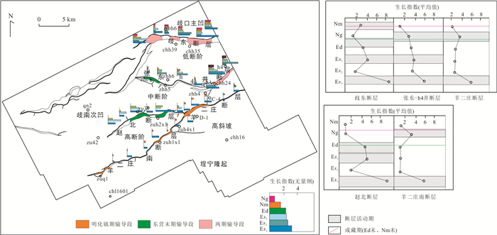
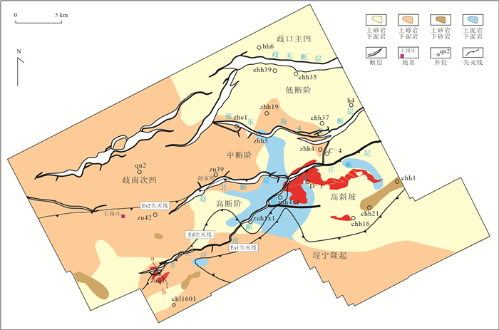
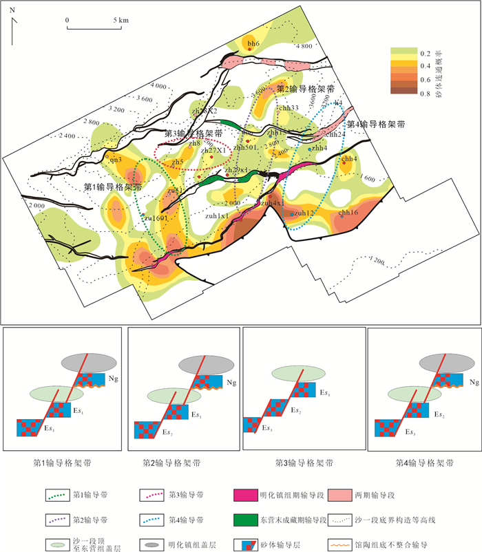
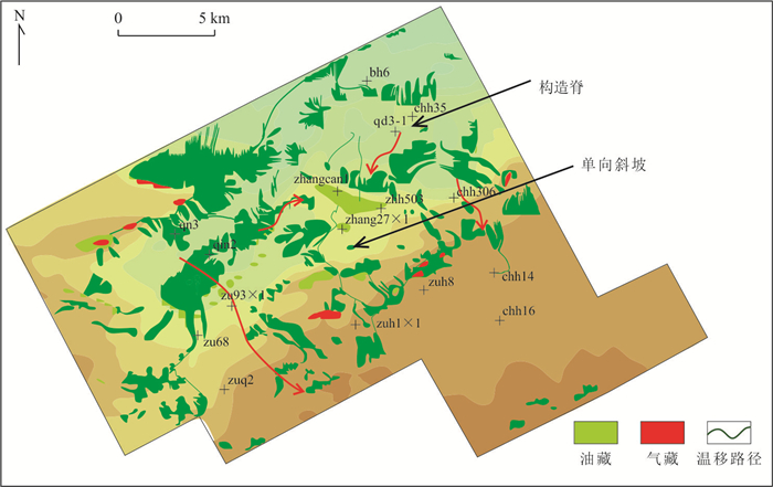
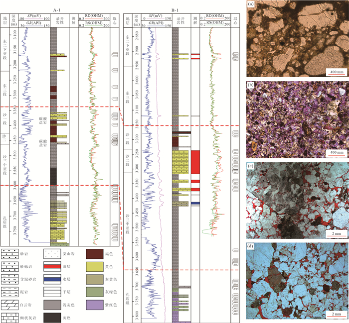
Influenced by tectonics and sedimentation, the complex pathway networks developed in ChengBei Fault Zone, consisting of faults, sand bodies and unconformities, which controlling petroleum migration and accumulation. Based on the seismic and logging data, the carrier networks were characterized systematically through the analysis on the transport performance of faults, sand bodies and unconformable surfaces in this paper. And the preferential migration pathways of hydrocarbon were traced by understanding the distribution and the physical and chemical properties of petroleum. The results showed that the two carrier layers were formed vertically, namely the third member-the second member-the lower part of the first member in Shahejie Formation, and the Guantao-Minghuazhen Formation, which were cutted by mudstone capcocks of the top part of Shahejie Formation and Dongying Formation, and Minghuazhen Formation. Chh24、h4 well areas are the leakage parts of hydrocarbon breaking through the upper part of the Dongying cap rock into the carriers of Guantao-Minghuazhen Formation. Horizontally, fault, sand body and unconformity surface constitute four major carrier belts: the first-third member of Shahejie Formation and the Guantao formation in Qinan Subsag and the areas of Youyi-Liu guanzhuang; the first-second member of Shahejie Formation and the Guantao formation around the lower and middle Chengbei Fault zone; the first-second-third member of Shahejie Formation from Qinan Subsag to the middle part of Chengbei Fault zone; the second-third member of Shahejie Formation and the Guantao formation in Zhang Dongdong areas. In these carrier belts, petroleum was enriched into structural ridges or monoclinal high points, which controlling the dominant migration direction. The composition of nitrogen compounds and the physical properties revealed that four potential migration pathways existed inside four major carrier belts respectively, developing main charging channels on a large scale. "Ladder" accumulating mode in ChengBei Fault Zone are mainly controlled by dual transport framework and four prefential migration pathways. Accordingly, the second-third member of Shahejie Formation in lower and middle part of ChengBei Fault Zone, and Guantao-Minghuazhen Formation in the high slope part are chosen as the potential areas, which will be beneficial to further discovery in similar areas.
Influenced by tectonics and sedimentation, the complex pathway networks developed in ChengBei Fault Zone, consisting of faults, sand bodies and unconformities, which controlling petroleum migration and accumulation. Based on the seismic and logging data, the carrier networks were characterized systematically through the analysis on the transport performance of faults, sand bodies and unconformable surfaces in this paper. And the preferential migration pathways of hydrocarbon were traced by understanding the distribution and the physical and chemical properties of petroleum. The results showed that the two carrier layers were formed vertically, namely the third member-the second member-the lower part of the first member in Shahejie Formation, and the Guantao-Minghuazhen Formation, which were cutted by mudstone capcocks of the top part of Shahejie Formation and Dongying Formation, and Minghuazhen Formation. Chh24、h4 well areas are the leakage parts of hydrocarbon breaking through the upper part of the Dongying cap rock into the carriers of Guantao-Minghuazhen Formation. Horizontally, fault, sand body and unconformity surface constitute four major carrier belts: the first-third member of Shahejie Formation and the Guantao formation in Qinan Subsag and the areas of Youyi-Liu guanzhuang; the first-second member of Shahejie Formation and the Guantao formation around the lower and middle Chengbei Fault zone; the first-second-third member of Shahejie Formation from Qinan Subsag to the middle part of Chengbei Fault zone; the second-third member of Shahejie Formation and the Guantao formation in Zhang Dongdong areas. In these carrier belts, petroleum was enriched into structural ridges or monoclinal high points, which controlling the dominant migration direction. The composition of nitrogen compounds and the physical properties revealed that four potential migration pathways existed inside four major carrier belts respectively, developing main charging channels on a large scale. "Ladder" accumulating mode in ChengBei Fault Zone are mainly controlled by dual transport framework and four prefential migration pathways. Accordingly, the second-third member of Shahejie Formation in lower and middle part of ChengBei Fault Zone, and Guantao-Minghuazhen Formation in the high slope part are chosen as the potential areas, which will be beneficial to further discovery in similar areas.


2023, 48(8): 3068-3080.
doi: 10.3799/dqkx.2022.052
Abstract:
The Central Structural Ridge, a synsedimentary subaqueous uplift controlled by strike-slip movement in Huanghekou Sag, is an important hydrocarbon bearing zone in Bohai Sea area. It is characterized by inapparent altitude difference, frequent internal reliefchange and strong reservoir heterogeneity. The characteristicsof sandbody distribution and reservoir development of thirdmemberof Shahejie Formationinthisbelt are not clear yet. In this paper, weconductpalaeogeomorphologic reconstruction bycombining seismic and drilling data and subdivide the belt into east, west and south parts. We separated the ranges of southern and northern source areas through light and heavy mineral data. Through synthetic analysis, we build the tectonic-deposition-reservoir patterns which could guide the exploration effectively. During the depositionof the thirdmemberof Shahejie Formation, the east Ridge was relativelylow and played the role of the major sediment channel. The sediment could transport longdistance towards the south with high maturity. The fractures developing inside the particles due to following tectonic inversion highly improved the permeability and resulted in development high-quality reservoirs. The west Ridge was relatively high and located aside the major channel and deposited thin sandstones with thick mudstone showing poor reservoir quality. The south Ridge located in the intersecting zone between north and south sediments adjacent to the central high landform causing strong carbonate cementing in sandstones.
The Central Structural Ridge, a synsedimentary subaqueous uplift controlled by strike-slip movement in Huanghekou Sag, is an important hydrocarbon bearing zone in Bohai Sea area. It is characterized by inapparent altitude difference, frequent internal reliefchange and strong reservoir heterogeneity. The characteristicsof sandbody distribution and reservoir development of thirdmemberof Shahejie Formationinthisbelt are not clear yet. In this paper, weconductpalaeogeomorphologic reconstruction bycombining seismic and drilling data and subdivide the belt into east, west and south parts. We separated the ranges of southern and northern source areas through light and heavy mineral data. Through synthetic analysis, we build the tectonic-deposition-reservoir patterns which could guide the exploration effectively. During the depositionof the thirdmemberof Shahejie Formation, the east Ridge was relativelylow and played the role of the major sediment channel. The sediment could transport longdistance towards the south with high maturity. The fractures developing inside the particles due to following tectonic inversion highly improved the permeability and resulted in development high-quality reservoirs. The west Ridge was relatively high and located aside the major channel and deposited thin sandstones with thick mudstone showing poor reservoir quality. The south Ridge located in the intersecting zone between north and south sediments adjacent to the central high landform causing strong carbonate cementing in sandstones.


2023, 48(8): 3081-3098.
doi: 10.3799/dqkx.2022.090
Abstract:
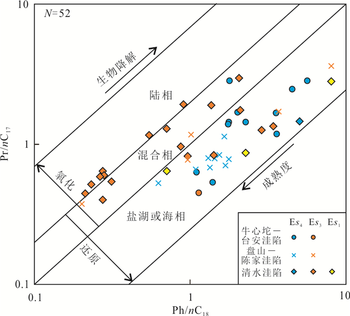
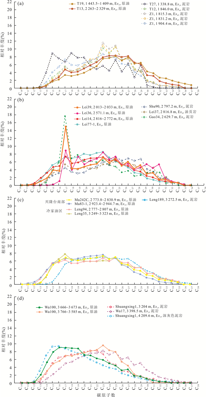
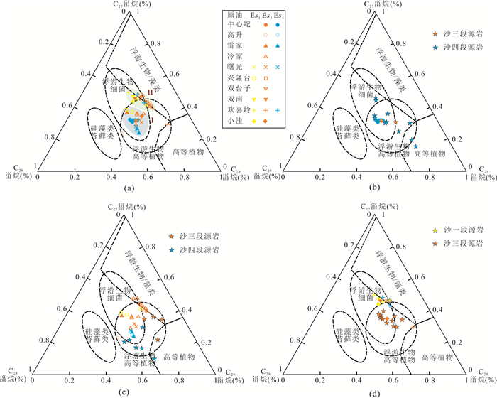
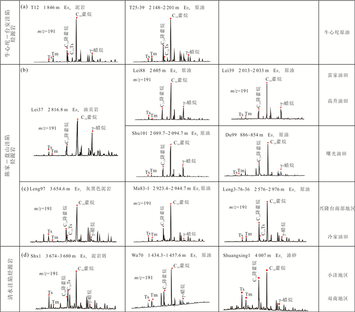
In order to clarify the differences in source rock characteristics and investigate the source of crude oil in different areas in the Liaohe Western Depression, the TOC, rock pyrolysis, Ro, and saturated hydrocarbon gas chromatography-mass spectrometry (GC-MS) are adopted to analyze the characteristics of source rock and crude oil, and the fine oil-source correlation is carried out. Results indicate that the Es4 source rock of Liaohe Western Depression is developed in the north (about 700 m), with high organic matter abundance but low maturity (Ro < 0.5%). The organic matter of Es4 source rock was dominated by terrestrial higher plants, mixed with a small amount of lower aquatic organisms, and the sedimentary environment was a partially reduced saline-brackish water environment; The Es3 and Es1 source rocks of Liaohe Western Depression are developed in the south with high abundance and maturity. The organic matter was mainly derived from aquatic organisms and deposited in the oxidized freshwater environment. Results show that the crude oil in the northern part comes from the Es4 source rock. The crude oil in the central part mainly comes from the Es3 source rock (the crude oil in the Lengjia area comes from the Es4 and Es3 source rock). The crude oil in the southern part comes from the Es3 and Es1 source rock.
In order to clarify the differences in source rock characteristics and investigate the source of crude oil in different areas in the Liaohe Western Depression, the TOC, rock pyrolysis, Ro, and saturated hydrocarbon gas chromatography-mass spectrometry (GC-MS) are adopted to analyze the characteristics of source rock and crude oil, and the fine oil-source correlation is carried out. Results indicate that the Es4 source rock of Liaohe Western Depression is developed in the north (about 700 m), with high organic matter abundance but low maturity (Ro < 0.5%). The organic matter of Es4 source rock was dominated by terrestrial higher plants, mixed with a small amount of lower aquatic organisms, and the sedimentary environment was a partially reduced saline-brackish water environment; The Es3 and Es1 source rocks of Liaohe Western Depression are developed in the south with high abundance and maturity. The organic matter was mainly derived from aquatic organisms and deposited in the oxidized freshwater environment. Results show that the crude oil in the northern part comes from the Es4 source rock. The crude oil in the central part mainly comes from the Es3 source rock (the crude oil in the Lengjia area comes from the Es4 and Es3 source rock). The crude oil in the southern part comes from the Es3 and Es1 source rock.


2023, 48(8): 3099-3114.
doi: 10.3799/dqkx.2023.137
Abstract:
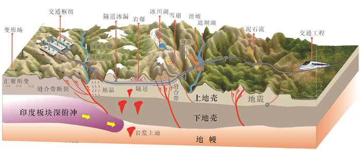
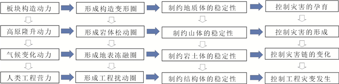
The essence of intense collision and continuous deformation of the Tibetan Plateau plate is the effect of the earth's sphere. It is also the key to explore the relationship of continuous tectonic deformation and shallow response, and catastrophe-pregnant mechanism. Based on the analyses of the dynamic background of sphere action on the Tibetan Plateau, this paper, from the perspective of engineering geology, divides the key zone of shallow crust into four types of the sphere, including tectonic deformation sphere, rock mass loosening sphere, surface freeze-thaw sphere, and engineering disturbance sphere. Meanwhile, this paper studies the deformation and failure law of rock-soil mass, the stability state and engineering safety of the rock-soil mass, as well as the behavior and mechanism of disaster in various spheres. This study shows that the mutual feedback of the four types of sphere has a profound impact on the geological body stability and disaster dynamic mechanism at different scales; that is, plate tectonic dynamic forms the tectonic deformation sphere, restricting the stability of regional geological body, and controlling the disaster-pregnant process; uplift dynamic of the plateau forms the rock mass loosening sphere, restricting the stability of engineering geological body, and controlling the formation of disasters; climatic change dynamic forms the surface freeze-thaw sphere, restricting the stability of engineering rock-soil mass, and controlling the evolution of disaster chains; human engineering force forms the engineering disturbance sphere, restricting the stability of engineering structures, and controlling the occurrence of engineering disasters. The lower sphere is inclusive of the upper sphere, and there is a progressive evolution law from bottom to top, which makes the rock-soil mass structure more complex, and the engineering geological problems and disaster effects more significant. This study provides a novel research idea for the geological safety risk prevention of major engineering construction.
The essence of intense collision and continuous deformation of the Tibetan Plateau plate is the effect of the earth's sphere. It is also the key to explore the relationship of continuous tectonic deformation and shallow response, and catastrophe-pregnant mechanism. Based on the analyses of the dynamic background of sphere action on the Tibetan Plateau, this paper, from the perspective of engineering geology, divides the key zone of shallow crust into four types of the sphere, including tectonic deformation sphere, rock mass loosening sphere, surface freeze-thaw sphere, and engineering disturbance sphere. Meanwhile, this paper studies the deformation and failure law of rock-soil mass, the stability state and engineering safety of the rock-soil mass, as well as the behavior and mechanism of disaster in various spheres. This study shows that the mutual feedback of the four types of sphere has a profound impact on the geological body stability and disaster dynamic mechanism at different scales; that is, plate tectonic dynamic forms the tectonic deformation sphere, restricting the stability of regional geological body, and controlling the disaster-pregnant process; uplift dynamic of the plateau forms the rock mass loosening sphere, restricting the stability of engineering geological body, and controlling the formation of disasters; climatic change dynamic forms the surface freeze-thaw sphere, restricting the stability of engineering rock-soil mass, and controlling the evolution of disaster chains; human engineering force forms the engineering disturbance sphere, restricting the stability of engineering structures, and controlling the occurrence of engineering disasters. The lower sphere is inclusive of the upper sphere, and there is a progressive evolution law from bottom to top, which makes the rock-soil mass structure more complex, and the engineering geological problems and disaster effects more significant. This study provides a novel research idea for the geological safety risk prevention of major engineering construction.


2023, 48(8): 3115-3126.
doi: 10.3799/dqkx.2021.127
Abstract:
The loose solid materials generated by a large amount of landslides triggered by meizoseismal area fill up the valley or river, which is easy to form a landslide dam. It breaks out and forms outburst debris flow under heavy rainfall and the scouring action of rainfall-runoff. In this study, 12 experiments were designed using the self-made flume to reproduce the failure process of landslide dams with different grain size distributions and hydrodynamic conditions. The failure process, breach discharge, and mechanical parameters are carried out. The landslide dams are divided into three instability modes: overtopping, sliding, and piping. The formation reasons of these three types of dam failure mode are analyzed combined with the grain size distributions of the landslide dams. Based on the dynamic characteristics, landslide dams' stability under different failure modes is established The research results are of great significance for the planning and designing prevention and control projects of the dam-break debris flow and improving the level of debris flow disaster prevention and mitigation.
The loose solid materials generated by a large amount of landslides triggered by meizoseismal area fill up the valley or river, which is easy to form a landslide dam. It breaks out and forms outburst debris flow under heavy rainfall and the scouring action of rainfall-runoff. In this study, 12 experiments were designed using the self-made flume to reproduce the failure process of landslide dams with different grain size distributions and hydrodynamic conditions. The failure process, breach discharge, and mechanical parameters are carried out. The landslide dams are divided into three instability modes: overtopping, sliding, and piping. The formation reasons of these three types of dam failure mode are analyzed combined with the grain size distributions of the landslide dams. Based on the dynamic characteristics, landslide dams' stability under different failure modes is established The research results are of great significance for the planning and designing prevention and control projects of the dam-break debris flow and improving the level of debris flow disaster prevention and mitigation.


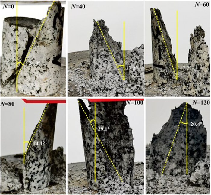
2023, 48(8): 3127-3136.
doi: 10.3799/dqkx.2023.002
Abstract:
Soft and hard interbedded rock slopes are widely distributed in meizoseismal areas of China and geological disasters are prone to be induced on such slopes due to earthquakes. In this paper, the key scientific issues of the dynamic response of soft and hard interbedded rock slopes under earthquakes were studied. The discrete element numerical simulation method was used to reveal the dynamic response of soft and hard interbedded rock slopes and influences of different slope factors on the dynamic response. The results show that bedding planes between soft and hard rocks play a main control role in the deformation and failure of the slope. Displacements obviously increase on the shear outlets and soft rock of the slope surface. Accelerations of seismic waves are amplified by soft and hard strata during the propagation of seismic wave and soft rocks have a significant amplification effect on the accelerations. The seismic wave spectra show that multiple fixed frequency bands are obviously amplified when the seismic wave propagates from hard rocks to soft rocks; the spectra decrease when the seismic wave propagates from soft rocks to hard rocks. The displacements and the amplification coefficients of acceleration decrease with the increase of the strength of soft rocks and bedding planes, while increase with the increase of thickness ratio. The locations of obviously amplified frequency bands are influenced by the strength of soft rocks and bedding planes. When the strength of soft rocks and bedding planes increase, the number of amplified bands remains the same and frequencies decrease. The reduction of the strength of bedding planes will not change the number and frequency of the amplified bands, but increase the degree of amplification.
Soft and hard interbedded rock slopes are widely distributed in meizoseismal areas of China and geological disasters are prone to be induced on such slopes due to earthquakes. In this paper, the key scientific issues of the dynamic response of soft and hard interbedded rock slopes under earthquakes were studied. The discrete element numerical simulation method was used to reveal the dynamic response of soft and hard interbedded rock slopes and influences of different slope factors on the dynamic response. The results show that bedding planes between soft and hard rocks play a main control role in the deformation and failure of the slope. Displacements obviously increase on the shear outlets and soft rock of the slope surface. Accelerations of seismic waves are amplified by soft and hard strata during the propagation of seismic wave and soft rocks have a significant amplification effect on the accelerations. The seismic wave spectra show that multiple fixed frequency bands are obviously amplified when the seismic wave propagates from hard rocks to soft rocks; the spectra decrease when the seismic wave propagates from soft rocks to hard rocks. The displacements and the amplification coefficients of acceleration decrease with the increase of the strength of soft rocks and bedding planes, while increase with the increase of thickness ratio. The locations of obviously amplified frequency bands are influenced by the strength of soft rocks and bedding planes. When the strength of soft rocks and bedding planes increase, the number of amplified bands remains the same and frequencies decrease. The reduction of the strength of bedding planes will not change the number and frequency of the amplified bands, but increase the degree of amplification.
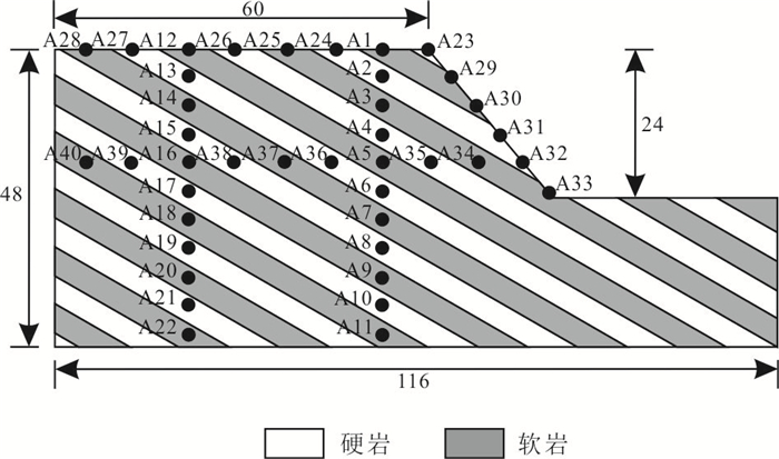
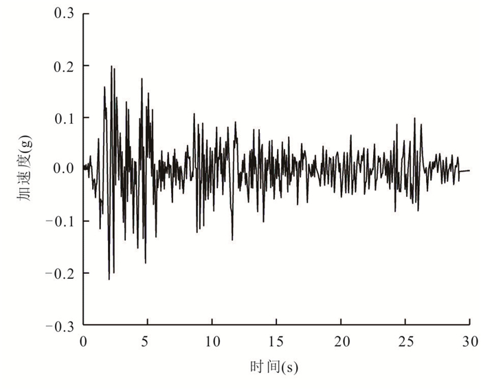

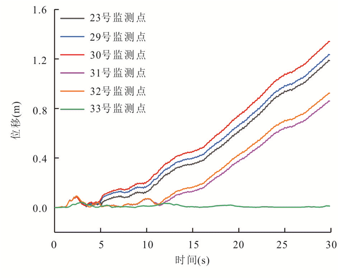

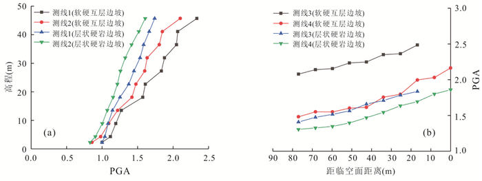
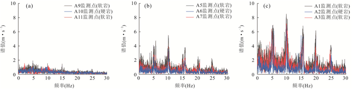


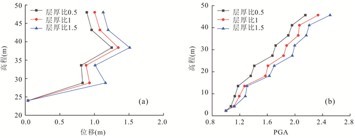
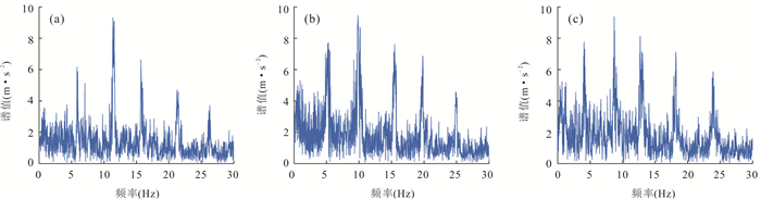
2023, 48(8): 3137-3150.
doi: 10.3799/dqkx.2022.462
Abstract:
Geotechnical engineering named entity recognition is an important prerequisite and the work foundation for geotechnical information mining and knowledge Graph. Aiming at the recognition and classification of named entities in geotechnical texts, this article first designs and constructs a named entity corpus of geotechnical engineering according to Standard for Fundamental Terms of Geotechnical Engineering (GB/T 50279-2014) and other national industry standards; and based on deep learning technologies, a named entity recognition and classification deep learning model GENER is proposed for geotechnical engineering text. In GENER, the distributed representation learning of geotechnical engineering text features is realized based on the BERT pretrained language model; the geotechnical engineering text context feature encoding is achieved based on the BiGRU context coding layer; and based on the label decoding layer of CRF, the context features are decoded to generate the label sequence of geotechnical engineering named entity. Finally, based on the geotechnical engineering corpus, the GENER model is experimentally analyzed. comparing with other deep learning models for named entity recognition based on pretrained language models, the GENER model has better performance. The precision reaches 90.94%, the recall reaches 92.88%, the F1-score reaches 91.89%and model training speed increased by 4.735% respectively.Experiments show that compared with BiLSTM-CRF and CNN-BiLSTM-CRF models, this model is more effective in small-scale corpus geotechnical engineering entity recognition.
Geotechnical engineering named entity recognition is an important prerequisite and the work foundation for geotechnical information mining and knowledge Graph. Aiming at the recognition and classification of named entities in geotechnical texts, this article first designs and constructs a named entity corpus of geotechnical engineering according to Standard for Fundamental Terms of Geotechnical Engineering (GB/T 50279-2014) and other national industry standards; and based on deep learning technologies, a named entity recognition and classification deep learning model GENER is proposed for geotechnical engineering text. In GENER, the distributed representation learning of geotechnical engineering text features is realized based on the BERT pretrained language model; the geotechnical engineering text context feature encoding is achieved based on the BiGRU context coding layer; and based on the label decoding layer of CRF, the context features are decoded to generate the label sequence of geotechnical engineering named entity. Finally, based on the geotechnical engineering corpus, the GENER model is experimentally analyzed. comparing with other deep learning models for named entity recognition based on pretrained language models, the GENER model has better performance. The precision reaches 90.94%, the recall reaches 92.88%, the F1-score reaches 91.89%and model training speed increased by 4.735% respectively.Experiments show that compared with BiLSTM-CRF and CNN-BiLSTM-CRF models, this model is more effective in small-scale corpus geotechnical engineering entity recognition.


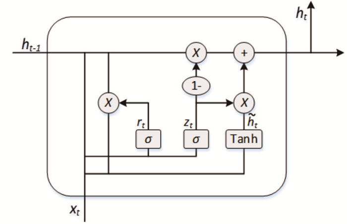


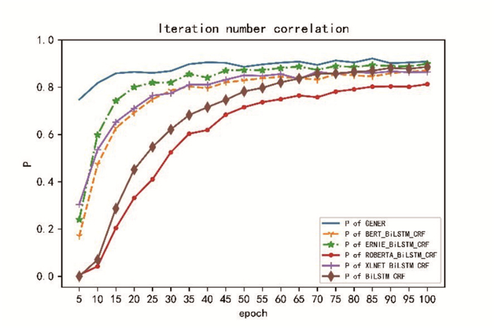
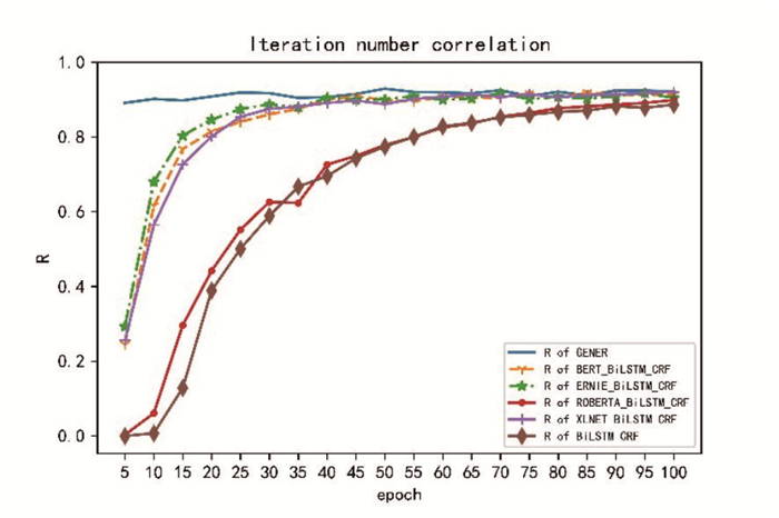


2023, 48(8): 3151-3161.
doi: 10.3799/dqkx.2021.232
Abstract:
With the development of deep learning technology, attackers can obtain potentially sensitive information from public geological data through classification, prediction, and other methods, which could lead to the leakage of important geological data. To solve the above problems, we propose a geological drilling data protection model based on graph adversarial attack Gcntack.Based on the degree properties of geological data topology, we first generate attacks that satisfy the same power-law distribution as tiny node disturbance. It can ensure that the adversarial attacks are not easy to be found, and while can change the classification result of the target node. Secondly, we introduce an attention mechanism. Using a graph attention network model based on interpretability, we analyze the properties of key nodes that directly affect the results of the adversarial attacks, so as to verify the rationality of the selecting adversarial nodes in the Gcntack model. Finally, a comprehensive evaluation, based on the benchmark dataset and geological drilling dataset, is presented to show this proposed scheme can reduce the prediction accuracy of attackers and achieve the purpose of protecting important geological drilling data.
With the development of deep learning technology, attackers can obtain potentially sensitive information from public geological data through classification, prediction, and other methods, which could lead to the leakage of important geological data. To solve the above problems, we propose a geological drilling data protection model based on graph adversarial attack Gcntack.Based on the degree properties of geological data topology, we first generate attacks that satisfy the same power-law distribution as tiny node disturbance. It can ensure that the adversarial attacks are not easy to be found, and while can change the classification result of the target node. Secondly, we introduce an attention mechanism. Using a graph attention network model based on interpretability, we analyze the properties of key nodes that directly affect the results of the adversarial attacks, so as to verify the rationality of the selecting adversarial nodes in the Gcntack model. Finally, a comprehensive evaluation, based on the benchmark dataset and geological drilling dataset, is presented to show this proposed scheme can reduce the prediction accuracy of attackers and achieve the purpose of protecting important geological drilling data.


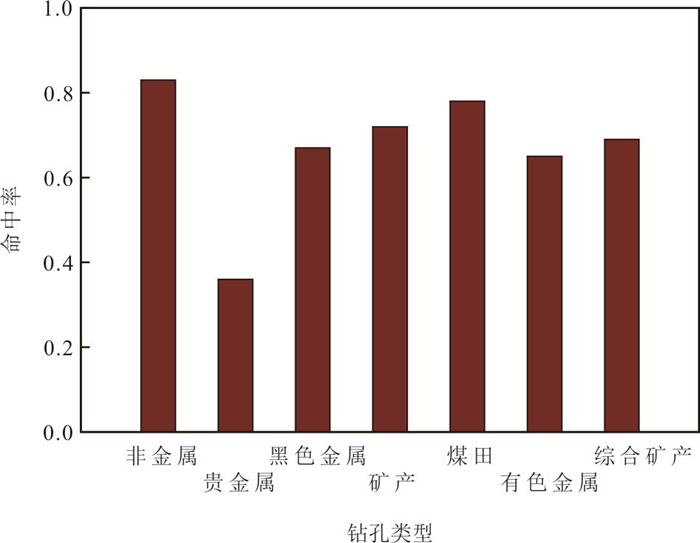

2023, 48(8): 3162-3178.
doi: 10.3799/dqkx.2023.014
Abstract:
In recent years, deep learning methods have been widely focused and applied in the field of seismic data processing and interpretation, where most deep learning algorithms employ end-to-end deep convolutional neural networks for the extraction and identification of geological features (e.g., stratum, fault, and salt dome). However, these algorithms often contain hundreds of thousands or even millions of trainable parameters, which lead to the model of parameter redundancy and low training efficiency. Therefore, a lightweight bi-directional multi-scale network is constructed for the intelligent identification of stratum. Specifically, the model eliminates the obvious redundant connections of the bi-directional multi-scale network structure through the two-stage Neural Architecture Search (NAS), which greatly simplifies the network structure, reduces the parameter redundancy, and improves the training efficiency. The Netherlands F3 dataset was used to train, verify and predict the simplified bi-directional multi-scale network by the NAS. The results show that the average recognition accuracy of the lightweight model reaches 95.52% in the actual stratigraphic identification task, and it has well generalization to the prediction work area far from the training work area. In addition, the number of parameters of the proposed model is only 4.4% of the U-shaped convolutional neural network (U-Net), and which outperforms the previous related work in terms of training efficiency and the number of model parameters. It is also robust when processing noisy seismic data. Therefore, the BiX-NAS network model has good prospects for application in practical automatic seismic stratigraphic identification.
In recent years, deep learning methods have been widely focused and applied in the field of seismic data processing and interpretation, where most deep learning algorithms employ end-to-end deep convolutional neural networks for the extraction and identification of geological features (e.g., stratum, fault, and salt dome). However, these algorithms often contain hundreds of thousands or even millions of trainable parameters, which lead to the model of parameter redundancy and low training efficiency. Therefore, a lightweight bi-directional multi-scale network is constructed for the intelligent identification of stratum. Specifically, the model eliminates the obvious redundant connections of the bi-directional multi-scale network structure through the two-stage Neural Architecture Search (NAS), which greatly simplifies the network structure, reduces the parameter redundancy, and improves the training efficiency. The Netherlands F3 dataset was used to train, verify and predict the simplified bi-directional multi-scale network by the NAS. The results show that the average recognition accuracy of the lightweight model reaches 95.52% in the actual stratigraphic identification task, and it has well generalization to the prediction work area far from the training work area. In addition, the number of parameters of the proposed model is only 4.4% of the U-shaped convolutional neural network (U-Net), and which outperforms the previous related work in terms of training efficiency and the number of model parameters. It is also robust when processing noisy seismic data. Therefore, the BiX-NAS network model has good prospects for application in practical automatic seismic stratigraphic identification.

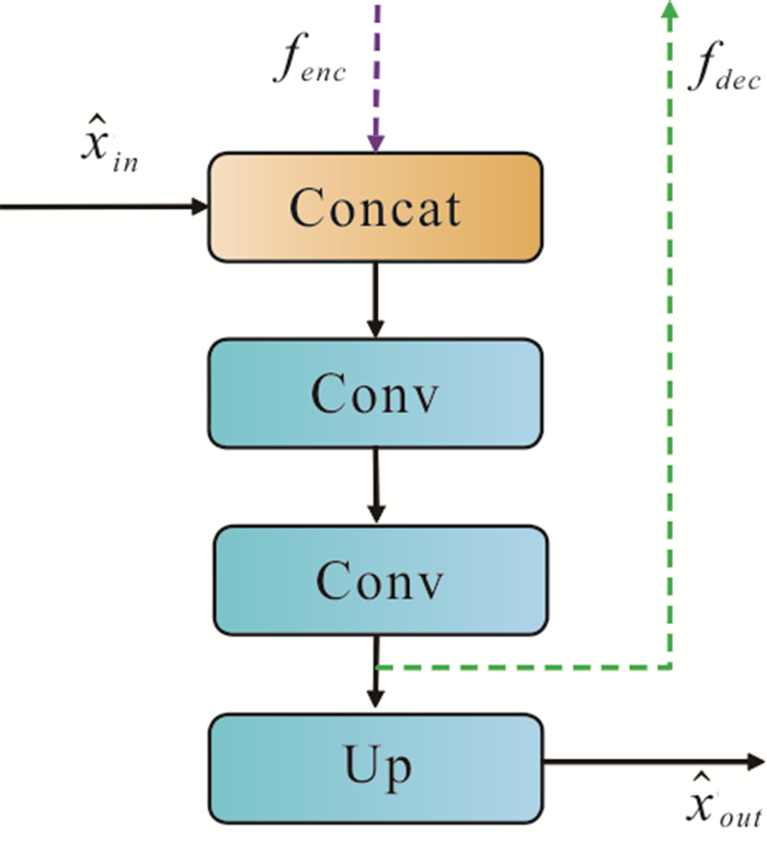


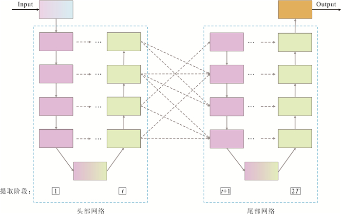
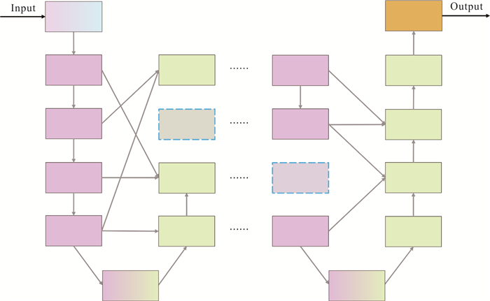


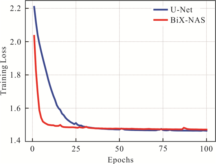

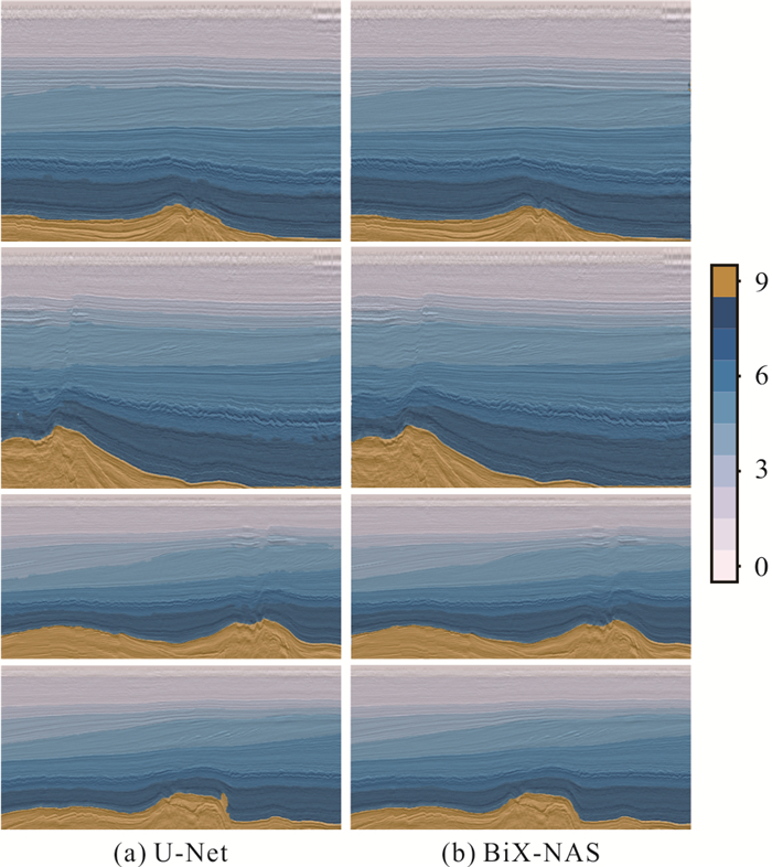


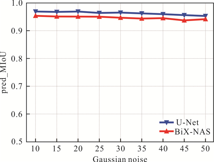

2023, 48(8): 3179-3192.
doi: 10.3799/dqkx.2021.139
Abstract:
In geological exploration, the bottom interface of deep stratum is not sampled in most boreholes, and incorrect sample information limits the accuracy of geological models. In order to improve the accuracy of geological model, we proposes a method to correct geological model based on stratigraphic interdependency. Due to the formation mechanism of the strata, the morphology of the adjacent strata is similar. Based on this character, the Copula function is used to model the dependence structure of adjacent strata, and the joint distribution model of adjacent strata and the likelihood function of the stratum to be corrected are constructed. In the Bayesian framework, the established interface model is taken as the prior model, and the likelihood function is used to update the prior model to obtain the posterior distribution. In the end, the condition expectation of the interface is calculated as the posterior model. The proposed approach is illustrated through a case study of the geological interface model of the coastal zone near Beihai. The results show that the error of the geological interface model is reduced after model correction.
In geological exploration, the bottom interface of deep stratum is not sampled in most boreholes, and incorrect sample information limits the accuracy of geological models. In order to improve the accuracy of geological model, we proposes a method to correct geological model based on stratigraphic interdependency. Due to the formation mechanism of the strata, the morphology of the adjacent strata is similar. Based on this character, the Copula function is used to model the dependence structure of adjacent strata, and the joint distribution model of adjacent strata and the likelihood function of the stratum to be corrected are constructed. In the Bayesian framework, the established interface model is taken as the prior model, and the likelihood function is used to update the prior model to obtain the posterior distribution. In the end, the condition expectation of the interface is calculated as the posterior model. The proposed approach is illustrated through a case study of the geological interface model of the coastal zone near Beihai. The results show that the error of the geological interface model is reduced after model correction.


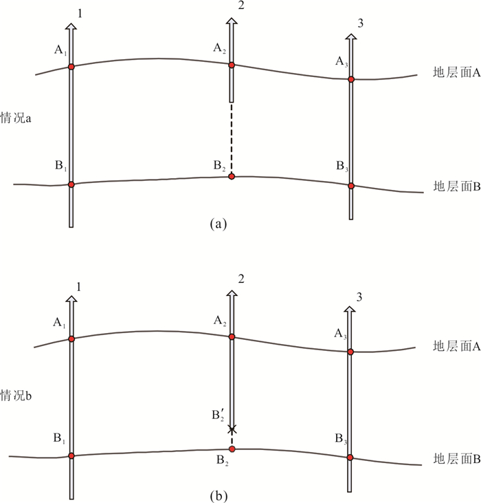

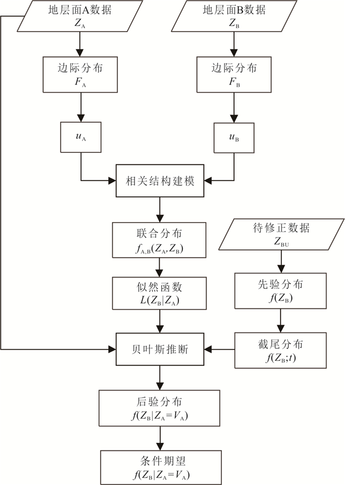


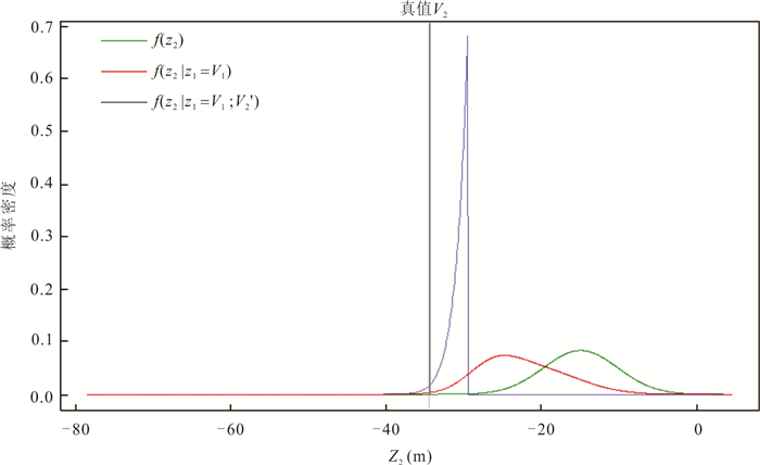

2023, 48(8): 3193-3204.
doi: 10.3799/dqkx.2022.421
Abstract:
Wuhan, the city of a hundred lakes, is one of the biggest cities with the richest lake resources in the world's inland cities, and has been certified as an "international wetland city" in 2022. In order to further promote the construction of "international wetland city", it is necessary to find out the formation and evolution history of lakes in Wuhan and its influencing factors. In this paper, the impacts of regional tectonic environment, river channel evolution, climate change and human activities on the formation and evolution, ecology and environment of lakes in Wuhan Area are systematically discussed. The results show that the causes and evolution of lakes in Wuhan Area have profound geological environment and climate background. Under the influence of neotectonic tilting and uplifting in the Quaternary, regional subsidence and depression created conditions for the formation of the lakes, and the warm and humid climate since the last deglaciation promoted the expansion of the lakes. Since the historical period, the evolution of estuary section of the lower Hanshui River has had a profound impact on the formation and evolution of lakes in Hankou and Hanyang districts. In the past hundred years, the increasing human activities have brought about the rapid shrinkage of lakes in Wuhan, pollution and ecological degradation, and the aggravation of drought and flood disasters. Therefore, rethinking profoundly the human-lake relationship, taking into account the long-term natural restoration of lake ecosystems and the irreversibility of serious ecosystem degradation caused by human activities, andestablishing a harmonious coexistence of human-lake relationship are crucial to theWuhan's urban ecological security.Based on the above historical lessons and problems of lake evolution, in the key period of current Yangtze River Protection and Wuhan's establishment of "international wetland city", we have targeted in "world wetland capital" strategic planning for Wuhan lake ecological protection, which need a top-level design on "the overall plans for the protection system of mountains, rivers, forests, farmland, lakes and grasslands", environment management and ecological restoration of pollution and degradation lake water", and "establishment of lake health management of Wuhan Paradigm", and further improvement on the lake ecological protection, management and evaluation system.The above research is not only conducive to building Wuhan into an "international wetland city", but also set a model role in building Wuhan into a "world wetland capital" and the thorough implementation of the strategy of "Yangtze River Protection".
Wuhan, the city of a hundred lakes, is one of the biggest cities with the richest lake resources in the world's inland cities, and has been certified as an "international wetland city" in 2022. In order to further promote the construction of "international wetland city", it is necessary to find out the formation and evolution history of lakes in Wuhan and its influencing factors. In this paper, the impacts of regional tectonic environment, river channel evolution, climate change and human activities on the formation and evolution, ecology and environment of lakes in Wuhan Area are systematically discussed. The results show that the causes and evolution of lakes in Wuhan Area have profound geological environment and climate background. Under the influence of neotectonic tilting and uplifting in the Quaternary, regional subsidence and depression created conditions for the formation of the lakes, and the warm and humid climate since the last deglaciation promoted the expansion of the lakes. Since the historical period, the evolution of estuary section of the lower Hanshui River has had a profound impact on the formation and evolution of lakes in Hankou and Hanyang districts. In the past hundred years, the increasing human activities have brought about the rapid shrinkage of lakes in Wuhan, pollution and ecological degradation, and the aggravation of drought and flood disasters. Therefore, rethinking profoundly the human-lake relationship, taking into account the long-term natural restoration of lake ecosystems and the irreversibility of serious ecosystem degradation caused by human activities, andestablishing a harmonious coexistence of human-lake relationship are crucial to theWuhan's urban ecological security.Based on the above historical lessons and problems of lake evolution, in the key period of current Yangtze River Protection and Wuhan's establishment of "international wetland city", we have targeted in "world wetland capital" strategic planning for Wuhan lake ecological protection, which need a top-level design on "the overall plans for the protection system of mountains, rivers, forests, farmland, lakes and grasslands", environment management and ecological restoration of pollution and degradation lake water", and "establishment of lake health management of Wuhan Paradigm", and further improvement on the lake ecological protection, management and evaluation system.The above research is not only conducive to building Wuhan into an "international wetland city", but also set a model role in building Wuhan into a "world wetland capital" and the thorough implementation of the strategy of "Yangtze River Protection".