2023 Vol. 48, No. 9
Display Method:
2023, 48(9): 3205-3220.
doi: 10.3799/dqkx.2023.078
 PDF 16681KB
Abstract:
The Yunkai domain is a key area where the ancient basement of the South China Block is exposed, and it records multi-stage, complex crustal reworking processes of the South China Block. The Pangxidong area is located in the southwestern margin of Yunkai, where the ancient basement fragments of the Yunkai group quartz mica schist are outcropped. In this study, detailed field geological, petrological and chronological analyses were conducted and the high-precision zircon U-Pb ages of granitic gneiss, gneissic granite and massive biotite granite in this area were obtained at ~450 Ma, ~440 Ma and ~105 Ma, respectively, indicating that this area has experienced episodic magmatism in the Caledonian and Yanshanian. There are several sets of ages (~470 Ma, ~450-430 Ma and ~390 Ma) found in the Early Paleozoic granitic rocks, suggesting that multiple episodes of magmatic processes may have occurred during the Caledonian. In addition, zircon ages of 228-219 Ma with low Th/U (0.01-0.03) and 101-99 Ma with high Th/U (0.30-0.78) were obtained in their dark rims, recording the overprints of the Indosinian metamorphic fluids and Yanshanian magmatic fluids. The zircon saturation temperature of the Yanshanian granite (~770 ℃) in the study area is higher than that of the Caledonian granite (~740-720 ℃), which may be due to the consumption of fusible components after multiple melting of the crust, and thus, higher temperatures are required for crustal partial melting. Their age spectrum of the granitoids is consistent with that of the ancient basement of South China, and they have the characteristics of S-type granite. These indicate the granitoids are mainly the products of ancient crustal remelting with insignificant mantle-derived material. Combined with regional geological, geochronological and geochemical data, the South China Block has at least experienced Caledonian (~470-390 Ma), Indosinian (~248-200 Ma) and Yanshanian (~180-90 Ma) crustal reconstruction/overprint of metamorphic and magmatic fluids since the Phanerozoic. The partial melting of ancient crustal materials mainly occurred in the Caledonian and Indosinian with few mantle-derived magma inputs, while the crustal melting in the Yanshanian was induced by adding mantle-derived heat with or without mantle materials input.
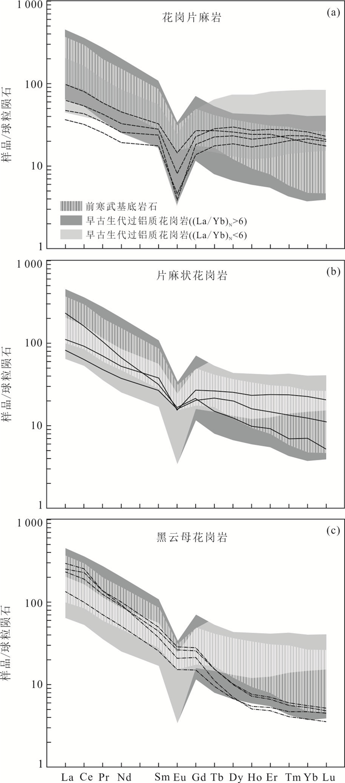
The Yunkai domain is a key area where the ancient basement of the South China Block is exposed, and it records multi-stage, complex crustal reworking processes of the South China Block. The Pangxidong area is located in the southwestern margin of Yunkai, where the ancient basement fragments of the Yunkai group quartz mica schist are outcropped. In this study, detailed field geological, petrological and chronological analyses were conducted and the high-precision zircon U-Pb ages of granitic gneiss, gneissic granite and massive biotite granite in this area were obtained at ~450 Ma, ~440 Ma and ~105 Ma, respectively, indicating that this area has experienced episodic magmatism in the Caledonian and Yanshanian. There are several sets of ages (~470 Ma, ~450-430 Ma and ~390 Ma) found in the Early Paleozoic granitic rocks, suggesting that multiple episodes of magmatic processes may have occurred during the Caledonian. In addition, zircon ages of 228-219 Ma with low Th/U (0.01-0.03) and 101-99 Ma with high Th/U (0.30-0.78) were obtained in their dark rims, recording the overprints of the Indosinian metamorphic fluids and Yanshanian magmatic fluids. The zircon saturation temperature of the Yanshanian granite (~770 ℃) in the study area is higher than that of the Caledonian granite (~740-720 ℃), which may be due to the consumption of fusible components after multiple melting of the crust, and thus, higher temperatures are required for crustal partial melting. Their age spectrum of the granitoids is consistent with that of the ancient basement of South China, and they have the characteristics of S-type granite. These indicate the granitoids are mainly the products of ancient crustal remelting with insignificant mantle-derived material. Combined with regional geological, geochronological and geochemical data, the South China Block has at least experienced Caledonian (~470-390 Ma), Indosinian (~248-200 Ma) and Yanshanian (~180-90 Ma) crustal reconstruction/overprint of metamorphic and magmatic fluids since the Phanerozoic. The partial melting of ancient crustal materials mainly occurred in the Caledonian and Indosinian with few mantle-derived magma inputs, while the crustal melting in the Yanshanian was induced by adding mantle-derived heat with or without mantle materials input.


2023, 48(9): 3221-3244.
doi: 10.3799/dqkx.2022.141
Abstract:
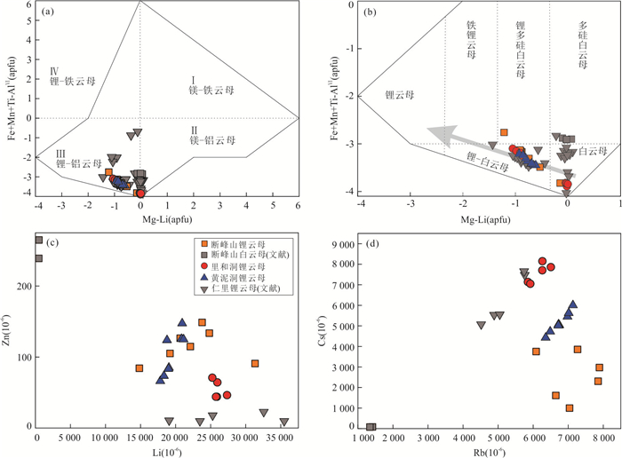
The Late Mesozoic Mufushan complex in South China is one of the most important rare metal mineralization areas in China, and giant rare metal deposits such as Renli-Chuanziyuan have been ascertained in its southern margin. In contrast, the metallogenic age and metallogenesis of rare metal-bearing pegmatites widely exposed in the northern are far from being understood. In this work, four major pegmatite concentrated areas in the northern margin of Mufushan including Duanfengshan, Beigang, Maishi and Huangnidong are studied. Based on detailed field investigation, petrography, mineral chemistry and columbite U-Pb dating, we discuss the metallogenic age, identify the occurrence of rare-metal (Li-Be-Nb-Ta), and decipher the mechanism of rare-metal (Li-Be-Nb-Ta) mineralization. Columbite U-Pb dating results show that the rare-metal mineralization of the northern Mufushan pegmatites occurred at 136-138 Ma, slightly postdating the Mufushan granitoids and together constituting a sequential granite emplacement, which represents products of extreme magmatic fractionation. Petrographic observations and mineral chemistry suggest that the major host minerals for Li are lepidolite, petalite and elbaite, for Be are beryl, for Nb are columbite and manganocolumbite, and for Ta are microlite and manganocolumbite. Chemical compositions of rare metal minerals record the evolution process of melt, indicating that fractional crystallization played a predominant role in controlling the successive enrichment of rare-metals. There are some differences in the Li-bearing minerals between the southern and northern margins of Mufushan, which may be due to the different P-T conditions. The large-scale rare metal mineralization of pegmatites indicates that the Mufushan area was in an extensional setting in the Early Cretaceous.
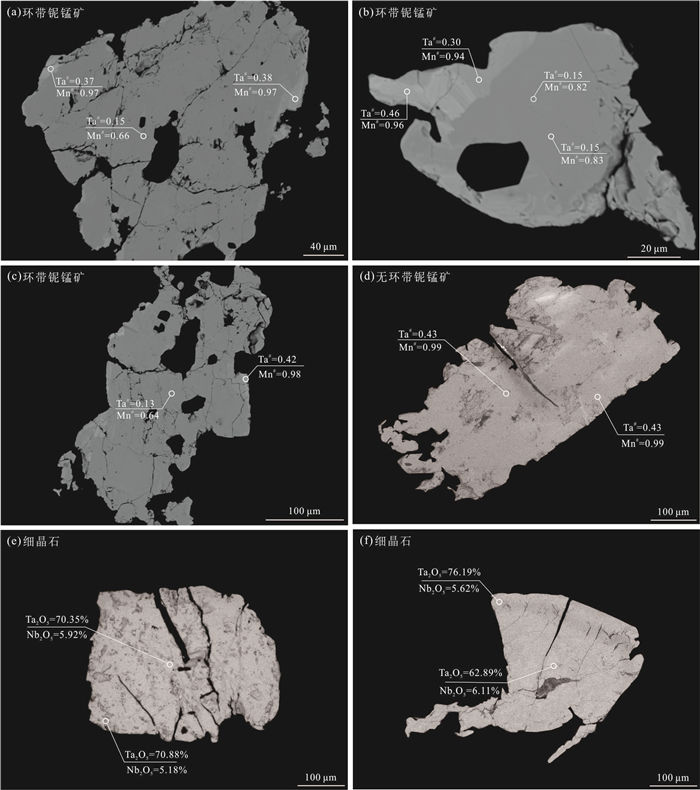
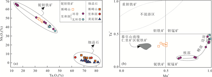
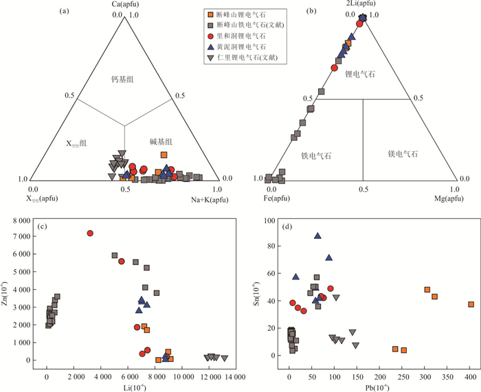
The Late Mesozoic Mufushan complex in South China is one of the most important rare metal mineralization areas in China, and giant rare metal deposits such as Renli-Chuanziyuan have been ascertained in its southern margin. In contrast, the metallogenic age and metallogenesis of rare metal-bearing pegmatites widely exposed in the northern are far from being understood. In this work, four major pegmatite concentrated areas in the northern margin of Mufushan including Duanfengshan, Beigang, Maishi and Huangnidong are studied. Based on detailed field investigation, petrography, mineral chemistry and columbite U-Pb dating, we discuss the metallogenic age, identify the occurrence of rare-metal (Li-Be-Nb-Ta), and decipher the mechanism of rare-metal (Li-Be-Nb-Ta) mineralization. Columbite U-Pb dating results show that the rare-metal mineralization of the northern Mufushan pegmatites occurred at 136-138 Ma, slightly postdating the Mufushan granitoids and together constituting a sequential granite emplacement, which represents products of extreme magmatic fractionation. Petrographic observations and mineral chemistry suggest that the major host minerals for Li are lepidolite, petalite and elbaite, for Be are beryl, for Nb are columbite and manganocolumbite, and for Ta are microlite and manganocolumbite. Chemical compositions of rare metal minerals record the evolution process of melt, indicating that fractional crystallization played a predominant role in controlling the successive enrichment of rare-metals. There are some differences in the Li-bearing minerals between the southern and northern margins of Mufushan, which may be due to the different P-T conditions. The large-scale rare metal mineralization of pegmatites indicates that the Mufushan area was in an extensional setting in the Early Cretaceous.


2023, 48(9): 3245-3257.
doi: 10.3799/dqkx.2022.118
Abstract:
Weathering-type kaolin deposits are widespread in South China, and they are associated with the intense intermediate-acid magmatism of granitic rocks and dikes. Ore-related magmatism were dominantly formed during the Caledonian and Yanshanian. However, no Kaolin mineralization associated with Triassic magmatism has been reported in South China so far. The Xiaokeng kaolin deposit, which has been discovered and explored recently, is a giant deposit with mineral resources more than 30 Mt in southern Jiangxi Province. The kaolin ore-bodies distribute on the surface of a muscovite granite as stratoid or crescent in shapes. It is a weathering-type kaolin deposit associated with granite and is characterized by low contents of iron and titanium. In this paper, the U-Pb laser ablation inductively coupled plasma mass spectrometry (LA-ICP-MS) dating of zircon and monazite, and Lu-Hf isotopes of zircon on kaolin ore are documented, in order to study the age and magmatic sources of ore-related granite. Mean ages of 231±2 to 230±2 Ma were obtained for two samples of zircon with intercept ages of 232±5 to 231±3 Ma. Based on micro-textures, and contents and ratios of trace and rare earth elements, a magmatic origin was proposed for monazite from kaolin ore at Xiaokeng. A yielded age of 230±1 Ma was obtained using U-Pb dating at monazite grains. These ages indicate that the ore-related granite was formed during the Late Triassic. Late Triassic zircon grains have εHf(t) values ranging from -19.9 to -1.2 with two-stages Hf model ages (TDM2) of 2 228-1 198 Ma. These Hf isotopic values, together with the presence of two Meso- to Neoproterozoic inherited zircon grains (1 018-987 Ma), indicate that the ore-related granite in the Xiaokeng deposit was originated from partial melting of Meso- to Neoproterozoic basement beneath South China, with minor contribution of mantle sources. This study on ages and sources of kaolin ore at Xiaokeng, not only suggests that Late Triassic tourmaline bearing muscovite or two-mica granites in South China can form high-quality weathering-type kaolin, but also expands the prospecting direction of kaolin deposits.
Weathering-type kaolin deposits are widespread in South China, and they are associated with the intense intermediate-acid magmatism of granitic rocks and dikes. Ore-related magmatism were dominantly formed during the Caledonian and Yanshanian. However, no Kaolin mineralization associated with Triassic magmatism has been reported in South China so far. The Xiaokeng kaolin deposit, which has been discovered and explored recently, is a giant deposit with mineral resources more than 30 Mt in southern Jiangxi Province. The kaolin ore-bodies distribute on the surface of a muscovite granite as stratoid or crescent in shapes. It is a weathering-type kaolin deposit associated with granite and is characterized by low contents of iron and titanium. In this paper, the U-Pb laser ablation inductively coupled plasma mass spectrometry (LA-ICP-MS) dating of zircon and monazite, and Lu-Hf isotopes of zircon on kaolin ore are documented, in order to study the age and magmatic sources of ore-related granite. Mean ages of 231±2 to 230±2 Ma were obtained for two samples of zircon with intercept ages of 232±5 to 231±3 Ma. Based on micro-textures, and contents and ratios of trace and rare earth elements, a magmatic origin was proposed for monazite from kaolin ore at Xiaokeng. A yielded age of 230±1 Ma was obtained using U-Pb dating at monazite grains. These ages indicate that the ore-related granite was formed during the Late Triassic. Late Triassic zircon grains have εHf(t) values ranging from -19.9 to -1.2 with two-stages Hf model ages (TDM2) of 2 228-1 198 Ma. These Hf isotopic values, together with the presence of two Meso- to Neoproterozoic inherited zircon grains (1 018-987 Ma), indicate that the ore-related granite in the Xiaokeng deposit was originated from partial melting of Meso- to Neoproterozoic basement beneath South China, with minor contribution of mantle sources. This study on ages and sources of kaolin ore at Xiaokeng, not only suggests that Late Triassic tourmaline bearing muscovite or two-mica granites in South China can form high-quality weathering-type kaolin, but also expands the prospecting direction of kaolin deposits.


2023, 48(9): 3258-3279.
doi: 10.3799/dqkx.2022.127
Abstract:
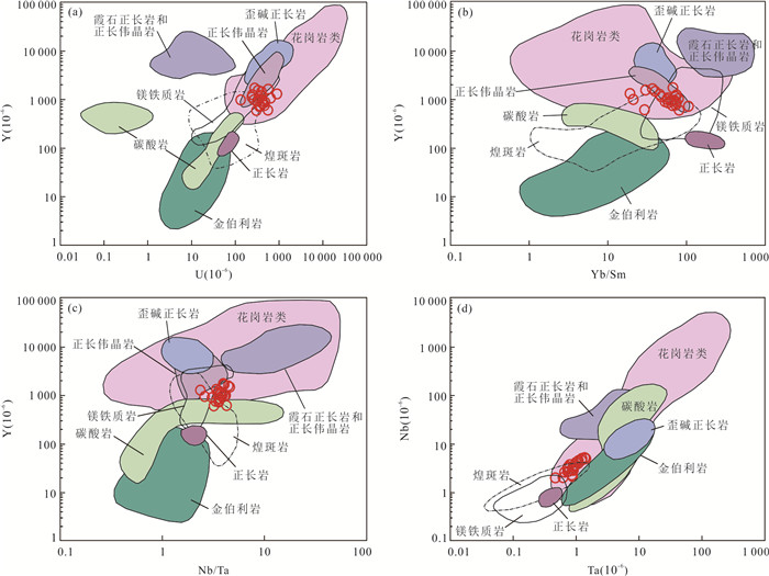
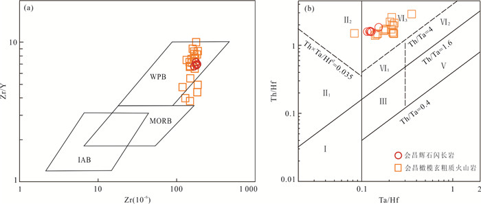
The spatial and temporal distribution of Mesozoic mantle-derived magma in South China is closely related with the metallogenic model of the granite-type uranium deposit. However, it has always been an important yet difficult issue of studies to explain the origin of zircon in mantle-derived magma and clarify the emplacement age of mantle-derived magma. Focusing on a newly discovered mantle-derived pyroxene diorite in the Huichang area, southern Jiangxi Province, this paper presents a systematic study on its mineralogy, mineral geochemistry, chronology and bulk geochemistry. The Huichang pyroxene diorite is characterized by SiO2 contents of 55.74%-57.71%, and enrichment in LREE and LILE, and depletion in HREE and HFSE. Apatite belongs to fluoroapatite, and the intercept age (115±4.9 Ma) and weighted mean 206Pb/238U age (114.7±2.3 Ma) of apatite represent the crystallization age of Huichang pyroxene diorite. While, the zircons have 206Pb/238U age of 233-271 Ma and εHf(t) value of -3.0 to -1.4, which indicate the captured zircon from Ⅰ-type granite. Combined with the previous regional geological data, the South China block was mainly in a compression environment in the Indosinian, forming a large number of S-type and Ⅰ-type granites. In the Cretaceous, the South China block was mainly in an extensional environment, and multiple stages of mantle-derived magmas underplating events occurred. In the extensional environment, meteoric water and mantle-derived fluids brought sufficient mineralizers such as O2 and CO2, which provided important conditions for leaching uranium from source bed and finally forming the uranium deposits.
The spatial and temporal distribution of Mesozoic mantle-derived magma in South China is closely related with the metallogenic model of the granite-type uranium deposit. However, it has always been an important yet difficult issue of studies to explain the origin of zircon in mantle-derived magma and clarify the emplacement age of mantle-derived magma. Focusing on a newly discovered mantle-derived pyroxene diorite in the Huichang area, southern Jiangxi Province, this paper presents a systematic study on its mineralogy, mineral geochemistry, chronology and bulk geochemistry. The Huichang pyroxene diorite is characterized by SiO2 contents of 55.74%-57.71%, and enrichment in LREE and LILE, and depletion in HREE and HFSE. Apatite belongs to fluoroapatite, and the intercept age (115±4.9 Ma) and weighted mean 206Pb/238U age (114.7±2.3 Ma) of apatite represent the crystallization age of Huichang pyroxene diorite. While, the zircons have 206Pb/238U age of 233-271 Ma and εHf(t) value of -3.0 to -1.4, which indicate the captured zircon from Ⅰ-type granite. Combined with the previous regional geological data, the South China block was mainly in a compression environment in the Indosinian, forming a large number of S-type and Ⅰ-type granites. In the Cretaceous, the South China block was mainly in an extensional environment, and multiple stages of mantle-derived magmas underplating events occurred. In the extensional environment, meteoric water and mantle-derived fluids brought sufficient mineralizers such as O2 and CO2, which provided important conditions for leaching uranium from source bed and finally forming the uranium deposits.


2023, 48(9): 3280-3295.
doi: 10.3799/dqkx.2022.023
Abstract:
The Hefeng area is located in the stratabound-type Pb-Zn polymetallic metallogenic belt in the junctional zone between western Hunan and western Hubei. It is not only one of the important producers of "Yangtze-type" Pb-Zn deposits, but also an important prospecting area of shale gas resources in China. In order to discuss the provenance, paleoweathering, sedimentary environment and tectonic setting of the Niutitang Formation, the petrology and petrochemistry of the black rock series in the middle and lower part of the Niutitang Formation in Zouma Town of Hefeng County are analyzed. The contents of major elements in the rock vary significantly, and the chemical composition of the samples from different layers is quite different. Except for SiO2 and P2O5, most of the compositions in the lower layer are lower than the PAAS value. The rocks are strongly enriched in U and Cr, but depleted in Th. They have high Ni/Co ratios and low V/Cr ratios. The total amount of REE is slightly higher than that of PAAS, with obvious Ce negative anomaly, weak Eu negative anomaly, and slightly larger Y/Ho ratio. The content of Al2O3 in the upper stratum is significantly higher than that in the lower strata. Compared with PAAS, most of the components are depleted except SiO2 and Na2O. The rocks are strongly enriched in V, U, and Ba, obviously depleted in Zn, Th, Ni, and Rb, with low Ni/Co ratios and high V/Cr ratios. The content of the total amount of REE is similar to that of the lower strata with the weak negative anomalies of Ce and Eu, and the Y/Ho ratios are similar to the values of igneous and terrigenous clastic rocks. It is considered that the Niutitang Formation were originated from terrigenous clastic rocks and neutral volcanic rocks, which have undergone strong weathering under humid to semi-arid climatic conditions, and were deposited in the palaeogeographic anoxic/dysoxic environment in the passive continental margin setting.
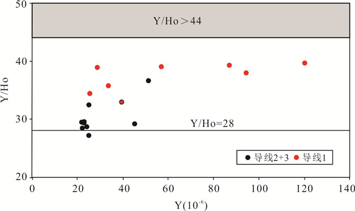
The Hefeng area is located in the stratabound-type Pb-Zn polymetallic metallogenic belt in the junctional zone between western Hunan and western Hubei. It is not only one of the important producers of "Yangtze-type" Pb-Zn deposits, but also an important prospecting area of shale gas resources in China. In order to discuss the provenance, paleoweathering, sedimentary environment and tectonic setting of the Niutitang Formation, the petrology and petrochemistry of the black rock series in the middle and lower part of the Niutitang Formation in Zouma Town of Hefeng County are analyzed. The contents of major elements in the rock vary significantly, and the chemical composition of the samples from different layers is quite different. Except for SiO2 and P2O5, most of the compositions in the lower layer are lower than the PAAS value. The rocks are strongly enriched in U and Cr, but depleted in Th. They have high Ni/Co ratios and low V/Cr ratios. The total amount of REE is slightly higher than that of PAAS, with obvious Ce negative anomaly, weak Eu negative anomaly, and slightly larger Y/Ho ratio. The content of Al2O3 in the upper stratum is significantly higher than that in the lower strata. Compared with PAAS, most of the components are depleted except SiO2 and Na2O. The rocks are strongly enriched in V, U, and Ba, obviously depleted in Zn, Th, Ni, and Rb, with low Ni/Co ratios and high V/Cr ratios. The content of the total amount of REE is similar to that of the lower strata with the weak negative anomalies of Ce and Eu, and the Y/Ho ratios are similar to the values of igneous and terrigenous clastic rocks. It is considered that the Niutitang Formation were originated from terrigenous clastic rocks and neutral volcanic rocks, which have undergone strong weathering under humid to semi-arid climatic conditions, and were deposited in the palaeogeographic anoxic/dysoxic environment in the passive continental margin setting.


2023, 48(9): 3296-3311.
doi: 10.3799/dqkx.2022.191
Abstract:
Triassic intermediate to acid magmatism is widely distributed in the central Tibetan Plateau (including the North Qiangtang terrane). However, the magma origin, petrogenesis and geodynamic mechanism of the magmas are still poorly understood. This paper presents an integrated study of zircon U-Pb geochronology, whole-rock and isotopic geochemistry for the Ningduo peraluminous granites from the North Qiangtang terrane, aiming to provide new insights into the generation of peraluminous granites and the Triassic tectonic-magmatic evolution of the central Tibetan Plateau. The lithology of the Ningduo peraluminous granites is biotite granodiorite, which is mainly composed of plagioclase (35%-40%), quartz (25%-30%), K-feldspar (15%-20%), and biotite (5%-10%). The crystallization age of the Ningduo granites is 248±1 Ma, which could be considered as the products of the Early Triassic magmatism. The Ningduo granites have moderate contents of SiO2 and MgO, and relatively high contents of K and Al, which can be comparable to those of typical strongly peraluminous granites. All the samples are featured with enrichment of large ion lithophile elements (e.g., Rb, K) and light rare earth elements, and depletion of high field strength elements (e.g., Nb, Ta, Ti, and P), relative to the primitive mantle. They have relatively high ISr ratios of 0.720-0.722, low εNd(t) values of -12.4 to -12.3, and old T2DM ages of 2.02-2.03 Ga, similar to those of the Proterozoic gneisses and Precambrian basement-derived S-type granites. The Ningduo granites have remarkable high zirconium saturation temperatures (806-845 ℃) and Ti-in-zircon temperatures (830-1 033 ℃), similar to those of typical high-temperature granites worldwide. The results indicate that the Ningduo granites were derived from partial melting of Precambrian basement rocks (greywacke and minor pelite rocks) under a high temperature condition. During the subduction of the Longmuco-Shuanghu Ocean, slab rollback triggered the back-arc extension and intense basaltic underplating, and then induced the high-temperature melting of Precambrian basement rocks.
Triassic intermediate to acid magmatism is widely distributed in the central Tibetan Plateau (including the North Qiangtang terrane). However, the magma origin, petrogenesis and geodynamic mechanism of the magmas are still poorly understood. This paper presents an integrated study of zircon U-Pb geochronology, whole-rock and isotopic geochemistry for the Ningduo peraluminous granites from the North Qiangtang terrane, aiming to provide new insights into the generation of peraluminous granites and the Triassic tectonic-magmatic evolution of the central Tibetan Plateau. The lithology of the Ningduo peraluminous granites is biotite granodiorite, which is mainly composed of plagioclase (35%-40%), quartz (25%-30%), K-feldspar (15%-20%), and biotite (5%-10%). The crystallization age of the Ningduo granites is 248±1 Ma, which could be considered as the products of the Early Triassic magmatism. The Ningduo granites have moderate contents of SiO2 and MgO, and relatively high contents of K and Al, which can be comparable to those of typical strongly peraluminous granites. All the samples are featured with enrichment of large ion lithophile elements (e.g., Rb, K) and light rare earth elements, and depletion of high field strength elements (e.g., Nb, Ta, Ti, and P), relative to the primitive mantle. They have relatively high ISr ratios of 0.720-0.722, low εNd(t) values of -12.4 to -12.3, and old T2DM ages of 2.02-2.03 Ga, similar to those of the Proterozoic gneisses and Precambrian basement-derived S-type granites. The Ningduo granites have remarkable high zirconium saturation temperatures (806-845 ℃) and Ti-in-zircon temperatures (830-1 033 ℃), similar to those of typical high-temperature granites worldwide. The results indicate that the Ningduo granites were derived from partial melting of Precambrian basement rocks (greywacke and minor pelite rocks) under a high temperature condition. During the subduction of the Longmuco-Shuanghu Ocean, slab rollback triggered the back-arc extension and intense basaltic underplating, and then induced the high-temperature melting of Precambrian basement rocks.


2023, 48(9): 3312-3326.
doi: 10.3799/dqkx.2022.381
Abstract:
To investigate the tectonic evolution process of the Paleo-Asian Ocean in the Abaga Banner, Inner Mongolia, this paper presents detailed petrological, zircon U⁃Pb chronological, and whole-rock geochemical studies of the volcanic rocks of the Baoligaomiao Formation. We redefine the Baoligaomiao Formation into four members. Zircon U⁃Pb ages of the second member amphibole andesite, the third member rhyolite and the fourth member rhyolitic crystal tuff yield a U⁃Pb age of 320.1±5.7 Ma, 315.1±4.1 Ma and 304.8±2.3 Ma, respectively. The Baoligaomiao volcanic rocks are characterized by high-K and weak peraluminous rocks affinities, belonging to sub-alkaline series, and they are interpreted to be formed by the product of partial melting of the thickened lower crust formed by mantle-derived magma underplating. The study area evolved from the continental margin arc tectonic environment recorded by the second member of the Baoligaomiao Formation to the collision by the third member of the volcanic rocks, until to post-collision environment by the fourth member of the volcanic rocks. Combined with the previous research results of the Early Permian magmatic activity in this area (product of the post-collision extensional stage), it is suggested that the Erenhot-Hegenshan oceanic basin of the Paleo Asian Ocean was in the process of oceanic slab destruction characterized by intra-oceanic subduction during the Late Carboniferous. A synthetic study of the geochemical characteristics of the Baoligaomiao volcanic rocks and the regional geological data reveals that the study area was in the setting of micro-continents collision during the late Late Carboniferous.
To investigate the tectonic evolution process of the Paleo-Asian Ocean in the Abaga Banner, Inner Mongolia, this paper presents detailed petrological, zircon U⁃Pb chronological, and whole-rock geochemical studies of the volcanic rocks of the Baoligaomiao Formation. We redefine the Baoligaomiao Formation into four members. Zircon U⁃Pb ages of the second member amphibole andesite, the third member rhyolite and the fourth member rhyolitic crystal tuff yield a U⁃Pb age of 320.1±5.7 Ma, 315.1±4.1 Ma and 304.8±2.3 Ma, respectively. The Baoligaomiao volcanic rocks are characterized by high-K and weak peraluminous rocks affinities, belonging to sub-alkaline series, and they are interpreted to be formed by the product of partial melting of the thickened lower crust formed by mantle-derived magma underplating. The study area evolved from the continental margin arc tectonic environment recorded by the second member of the Baoligaomiao Formation to the collision by the third member of the volcanic rocks, until to post-collision environment by the fourth member of the volcanic rocks. Combined with the previous research results of the Early Permian magmatic activity in this area (product of the post-collision extensional stage), it is suggested that the Erenhot-Hegenshan oceanic basin of the Paleo Asian Ocean was in the process of oceanic slab destruction characterized by intra-oceanic subduction during the Late Carboniferous. A synthetic study of the geochemical characteristics of the Baoligaomiao volcanic rocks and the regional geological data reveals that the study area was in the setting of micro-continents collision during the late Late Carboniferous.


2023, 48(9): 3327-3341.
doi: 10.3799/dqkx.2022.347
Abstract:
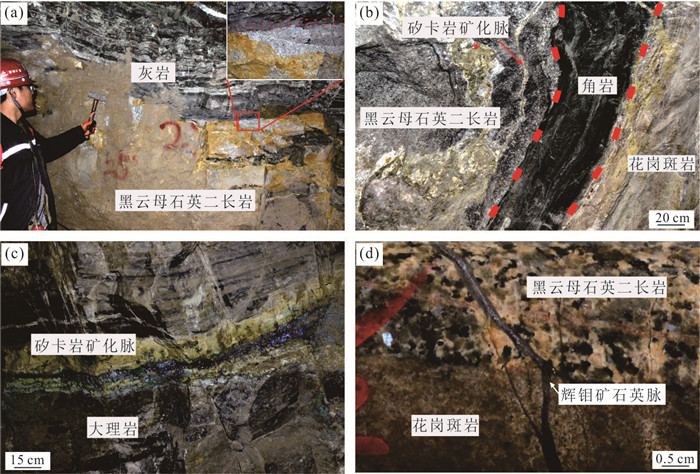
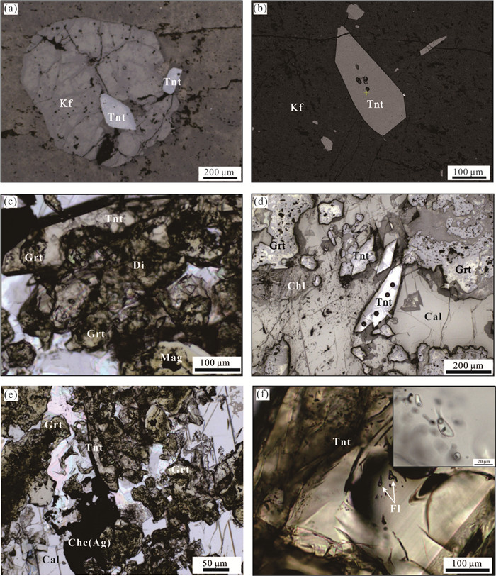
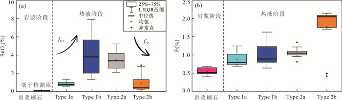
The Diaoquan deposit is a typical porphyry-skarn polymetallic deposit in the Wutaishan-Hengshan metallogenic district, North China. However, the relationship between porphyry and skarn mineralization processes have been the subject of intense debate. In this paper, in-situ laser ablation inductively coupled plasma mass spectrometry (LA-ICP-MS) has been applied to U-Pb isotope and trace elements analysis of the zircon and titanite from granitic porphyry, biotite-quartz monzonite, and mineralized skarn. Zircons from biotite-quartz monzonite and granitic porphyry have weighted mean U-Pb ages of 137.3± 1.2 Ma and 133.5±2.0 Ma, respectively. The age of granitic porphyry is consistent with the hydrothermal titanite U-Pb ages (133.6±2.2 Ma and 132.8±2.5 Ma) of the mineralized skarn, suggesting the Cu-Ag skarn mineralization at the Diaoquan deposit was caused by coeval magmatism that related to the emplacement of granitic porphyry. The variation of Sn contents in titanite from the Diaoquan deposit suggest the oxygen fugacity of hydrothermal mineralization fluids significantly increase at prograde skarn stage, and then slightly decreased at retrograde skarn stage.
The Diaoquan deposit is a typical porphyry-skarn polymetallic deposit in the Wutaishan-Hengshan metallogenic district, North China. However, the relationship between porphyry and skarn mineralization processes have been the subject of intense debate. In this paper, in-situ laser ablation inductively coupled plasma mass spectrometry (LA-ICP-MS) has been applied to U-Pb isotope and trace elements analysis of the zircon and titanite from granitic porphyry, biotite-quartz monzonite, and mineralized skarn. Zircons from biotite-quartz monzonite and granitic porphyry have weighted mean U-Pb ages of 137.3± 1.2 Ma and 133.5±2.0 Ma, respectively. The age of granitic porphyry is consistent with the hydrothermal titanite U-Pb ages (133.6±2.2 Ma and 132.8±2.5 Ma) of the mineralized skarn, suggesting the Cu-Ag skarn mineralization at the Diaoquan deposit was caused by coeval magmatism that related to the emplacement of granitic porphyry. The variation of Sn contents in titanite from the Diaoquan deposit suggest the oxygen fugacity of hydrothermal mineralization fluids significantly increase at prograde skarn stage, and then slightly decreased at retrograde skarn stage.


2023, 48(9): 3342-3359.
doi: 10.3799/dqkx.2023.077
Abstract:
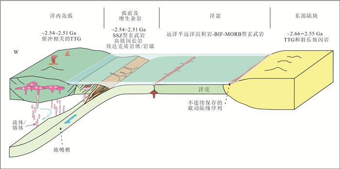
Tonalite-trondhjemite-granodiorite (TTG) is the most important component of the early continental crust of the Earth, which is closely related to the early tectonic environment and crustal differentiation process. By means of petrography, rare earth element differentiation, U-Pb age and Hf model age of zircon and trace element simulation based on the partial melting degree, this paper defines the protolith of TTG gneiss in Dengfeng area and its residual phase during partial melting. Meanwhile, zircon U-Pb dating shows that Dengfeng complex recorded two TTG magmatism (2.57-2.55 Ga and 2.55-2.51 Ga). TTG in Dengfeng complex has high εHf(t) and εNd(t) values (1.7-9.7 and 0.23-3.87), which are close to the depleted mantle values of the same period. In addition, TTG gneiss has high SiO2, Na2O, La/Yb and Sr/Y ratios and low Mg#, Cr, Ni, Yb, and Y contents. These data indicate that the rocks in the Dengfeng area represent the main components of mature crust. It is suggested by various data, including rock types, structural patterns, and geochemistry, that the greenstone belt combination (metamorphic volcanic sedimentary rocks) within the Dengfeng complex is forearc and accretionary terranes. The TTG-dominated Dengfeng complexes in the eastern and western parts may represent the island arc's core, and they collectively constitute the signature product of plate convergence. Further simulations of trace elements indicate that TTG gneisses in the Dengfeng area were partially melted from hydrated basaltic (amphibolite) rocks of the subducted oceanic crust, leaving behind garnet-bearing amphibolite residues. As such, we can infer that there was significant growth of young crust during this period, and the late Neoarchean TTG gneiss (2.57- 2.50 Ga) found along the southern margin of the North China Craton provides evidence to the formation of a new continental crust.
Tonalite-trondhjemite-granodiorite (TTG) is the most important component of the early continental crust of the Earth, which is closely related to the early tectonic environment and crustal differentiation process. By means of petrography, rare earth element differentiation, U-Pb age and Hf model age of zircon and trace element simulation based on the partial melting degree, this paper defines the protolith of TTG gneiss in Dengfeng area and its residual phase during partial melting. Meanwhile, zircon U-Pb dating shows that Dengfeng complex recorded two TTG magmatism (2.57-2.55 Ga and 2.55-2.51 Ga). TTG in Dengfeng complex has high εHf(t) and εNd(t) values (1.7-9.7 and 0.23-3.87), which are close to the depleted mantle values of the same period. In addition, TTG gneiss has high SiO2, Na2O, La/Yb and Sr/Y ratios and low Mg#, Cr, Ni, Yb, and Y contents. These data indicate that the rocks in the Dengfeng area represent the main components of mature crust. It is suggested by various data, including rock types, structural patterns, and geochemistry, that the greenstone belt combination (metamorphic volcanic sedimentary rocks) within the Dengfeng complex is forearc and accretionary terranes. The TTG-dominated Dengfeng complexes in the eastern and western parts may represent the island arc's core, and they collectively constitute the signature product of plate convergence. Further simulations of trace elements indicate that TTG gneisses in the Dengfeng area were partially melted from hydrated basaltic (amphibolite) rocks of the subducted oceanic crust, leaving behind garnet-bearing amphibolite residues. As such, we can infer that there was significant growth of young crust during this period, and the late Neoarchean TTG gneiss (2.57- 2.50 Ga) found along the southern margin of the North China Craton provides evidence to the formation of a new continental crust.


2023, 48(9): 3360-3377.
doi: 10.3799/dqkx.2022.126
Abstract:
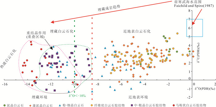
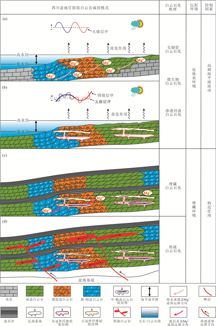
The dolomite in the Sinian Dengying Formation is a new and significant field for ultra-deep oil and gas exploration in the Sichuan basin. However, the forming model remains controversial without systematic research. In this study, detailed C-O-Sr and the rare earth element (REE) analyses were carried out on the Dengying Formation dolomites to investigate the geochemical characteristics and the source of dolomitization fluids, and further to constrain the differences of their origins. (1) The carbon isotopic values of the dolomites in the Dengying Formation are relatively homogeneous (0‰ to +5.0‰), while their oxygen isotopic values range widely. The dolomitic matrix and early dolomite cement in the near-surface realm show higher δ18O values than -8.0‰, δ18O values of the dolomite cement in the burial condition are more negative than -8.0‰, and those of the hydrothermal dolomite are more negative than -10.0‰. (2) The strontium isotopic ratios of the dolomitic matrix and early dolomite cement vary in a narrow range of 0.708-0.709, which is close to the Ediacaran marine carbonate, indicating the source of seawater. While those of dolomite cement in burial realm are more positive than the coeval seawater, indicating the source of formation fluids. (3) The dolomites in the Dengying Formation show depletion of light rare earth elements (LREEs) and enrichment of heavy rare earth elements (HREEs). The matrix and early dolomite cement have negative Ce anomalies with the absence of Eu anomalies, indicating a marine source. The dolomitic cements in the burial condition have negative Ce anomalies and significant positive Eu anomalies. The geochemical features and the origin of dolomitization fluids in different sedimentary environments are the essential factors controlling the formation of the Dengying Formation dolomite in the Sichuan basin. Dolomitization fluid in the near-surface environment is mainly derived from seawater, which is controlled by high-frequency sea-level fluctuations in an 'aragonite-dolomite sea' environment during the Sinian. By contrast, dolomitization fluids in burial environments are formation fluids and mantle-sourced hydrothermal fluid, which are mainly controlled by tectonic events. This research could facilitate further studies on the dolomite origin, the geochemical conditions of the terminal Neoproterozoic Ediacaran seawater, and the exploration and development of the ultra-deep oil and gas.
The dolomite in the Sinian Dengying Formation is a new and significant field for ultra-deep oil and gas exploration in the Sichuan basin. However, the forming model remains controversial without systematic research. In this study, detailed C-O-Sr and the rare earth element (REE) analyses were carried out on the Dengying Formation dolomites to investigate the geochemical characteristics and the source of dolomitization fluids, and further to constrain the differences of their origins. (1) The carbon isotopic values of the dolomites in the Dengying Formation are relatively homogeneous (0‰ to +5.0‰), while their oxygen isotopic values range widely. The dolomitic matrix and early dolomite cement in the near-surface realm show higher δ18O values than -8.0‰, δ18O values of the dolomite cement in the burial condition are more negative than -8.0‰, and those of the hydrothermal dolomite are more negative than -10.0‰. (2) The strontium isotopic ratios of the dolomitic matrix and early dolomite cement vary in a narrow range of 0.708-0.709, which is close to the Ediacaran marine carbonate, indicating the source of seawater. While those of dolomite cement in burial realm are more positive than the coeval seawater, indicating the source of formation fluids. (3) The dolomites in the Dengying Formation show depletion of light rare earth elements (LREEs) and enrichment of heavy rare earth elements (HREEs). The matrix and early dolomite cement have negative Ce anomalies with the absence of Eu anomalies, indicating a marine source. The dolomitic cements in the burial condition have negative Ce anomalies and significant positive Eu anomalies. The geochemical features and the origin of dolomitization fluids in different sedimentary environments are the essential factors controlling the formation of the Dengying Formation dolomite in the Sichuan basin. Dolomitization fluid in the near-surface environment is mainly derived from seawater, which is controlled by high-frequency sea-level fluctuations in an 'aragonite-dolomite sea' environment during the Sinian. By contrast, dolomitization fluids in burial environments are formation fluids and mantle-sourced hydrothermal fluid, which are mainly controlled by tectonic events. This research could facilitate further studies on the dolomite origin, the geochemical conditions of the terminal Neoproterozoic Ediacaran seawater, and the exploration and development of the ultra-deep oil and gas.


2023, 48(9): 3378-3388.
doi: 10.3799/dqkx.2021.130
Abstract:
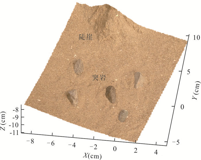
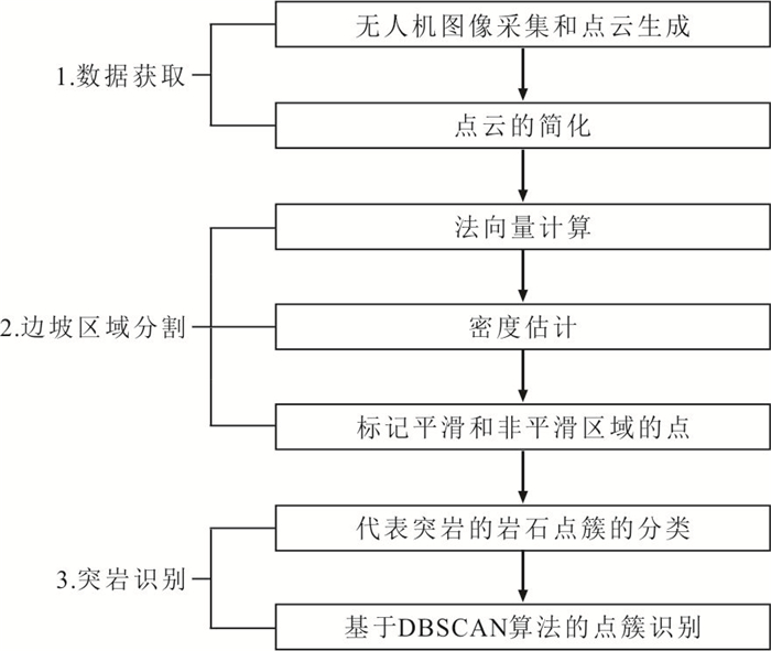
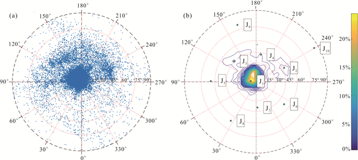
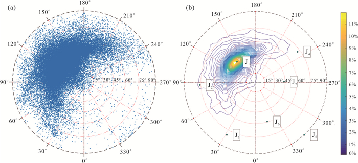
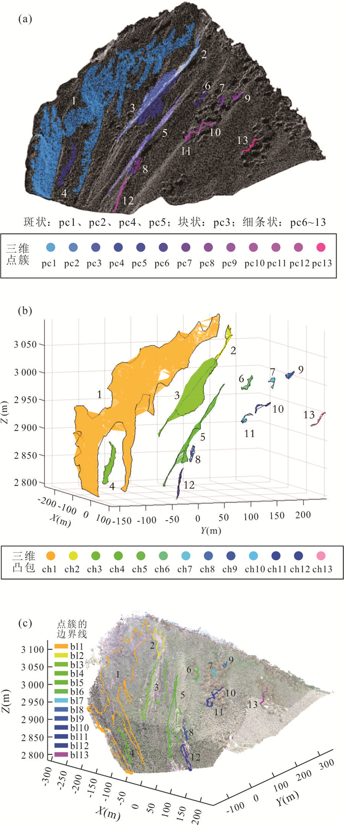
The rocky ledge on steep, high slopes is easy to lose stability under the action of gravity, earthquake, excavation and unloading, etc., which threatens the safety of water conservancy projects. Therefore, the early investigation of rocky ledge is of great significance. However, due to the large slope area and inconvenient traffic, the manual identification is time-consuming and dangerous. A rapid identification method for the rock ledge based on unmanned aerial vehicle (UAV) photogrammetry is proposed in this paper. This method consists of three steps: (1) Generate the point cloud model by UAV photogrammetry; (2) segment the slopes into smooth areas and non-smooth areas by kernel density estimation (KDE) of the point's normal vector, clustering the points of non-smooth areas by the density-based spatial clustering of applications with noise (DBSCAN); (3) classify the point clusters representing rocky ledge by the geometric feature. The method can identify possible rocky ledge from the whole slope, which reduces the artificial workload. The proposed method has been successfully applied to the slopes near Lianghekou hydropower station to obtain boundaries and geometric features of rocky ledges which will provide basic data for the future stability analysis.
The rocky ledge on steep, high slopes is easy to lose stability under the action of gravity, earthquake, excavation and unloading, etc., which threatens the safety of water conservancy projects. Therefore, the early investigation of rocky ledge is of great significance. However, due to the large slope area and inconvenient traffic, the manual identification is time-consuming and dangerous. A rapid identification method for the rock ledge based on unmanned aerial vehicle (UAV) photogrammetry is proposed in this paper. This method consists of three steps: (1) Generate the point cloud model by UAV photogrammetry; (2) segment the slopes into smooth areas and non-smooth areas by kernel density estimation (KDE) of the point's normal vector, clustering the points of non-smooth areas by the density-based spatial clustering of applications with noise (DBSCAN); (3) classify the point clusters representing rocky ledge by the geometric feature. The method can identify possible rocky ledge from the whole slope, which reduces the artificial workload. The proposed method has been successfully applied to the slopes near Lianghekou hydropower station to obtain boundaries and geometric features of rocky ledges which will provide basic data for the future stability analysis.


2023, 48(9): 3389-3401.
doi: 10.3799/dqkx.2022.329
Abstract:
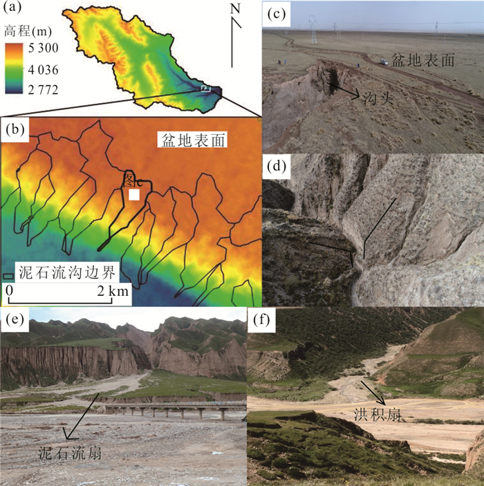
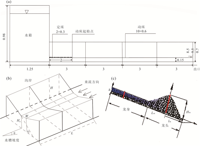
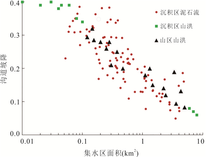
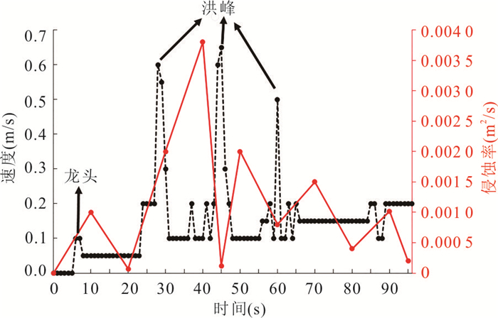
Uplift of the Qinghai-Tibet Plateau result in accelerating fluvial incision of the Yellow River. The incision of the Yellow River makes Daheba River, one of the tributaries of the Yellow River, incise quickly on the flat and broad Tongde basin covered by deep fluvial sediments and loess. Tongde basin has changed from sedimentary area to erosion area, and debris flow are developing. The study on the mechanism of debris flow groups occurrence is of great significance to the prevention and mitigation of debris flow in paleosedimentary basins. This paper analyzed the characteristics of sediments soil mechanics, water system of Daheba River and the mechanism of erosin and motion of debris flow through field investigation and physical model. Analysis showed that the Daheba River incised on thick lacustrine sediments and the sediments composed by gravel and sand, good sorting, were beneficial to the formation of debris flow. Under the condition of uplift of Qinghai-Tibet Plateau and rapid incisions of Yellow River, the headward erosion of Daheba River had made the river energy gradually extend upstream. Therefore, different distribution and development characteristics were at different river sections of Daheba River. The thickness and incision depth of pebble sand sediment layer determine the erosion intensity and development trend of debris flow. The intermittent energy source of debris flow head is caused by the process of water flow incision, debris flow erosion, pebble sand separation and collapse, which promotes the fluctuation of debris flow movement.
Uplift of the Qinghai-Tibet Plateau result in accelerating fluvial incision of the Yellow River. The incision of the Yellow River makes Daheba River, one of the tributaries of the Yellow River, incise quickly on the flat and broad Tongde basin covered by deep fluvial sediments and loess. Tongde basin has changed from sedimentary area to erosion area, and debris flow are developing. The study on the mechanism of debris flow groups occurrence is of great significance to the prevention and mitigation of debris flow in paleosedimentary basins. This paper analyzed the characteristics of sediments soil mechanics, water system of Daheba River and the mechanism of erosin and motion of debris flow through field investigation and physical model. Analysis showed that the Daheba River incised on thick lacustrine sediments and the sediments composed by gravel and sand, good sorting, were beneficial to the formation of debris flow. Under the condition of uplift of Qinghai-Tibet Plateau and rapid incisions of Yellow River, the headward erosion of Daheba River had made the river energy gradually extend upstream. Therefore, different distribution and development characteristics were at different river sections of Daheba River. The thickness and incision depth of pebble sand sediment layer determine the erosion intensity and development trend of debris flow. The intermittent energy source of debris flow head is caused by the process of water flow incision, debris flow erosion, pebble sand separation and collapse, which promotes the fluctuation of debris flow movement.


2023, 48(9): 3402-3419.
doi: 10.3799/dqkx.2021.124
Abstract:
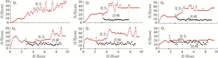
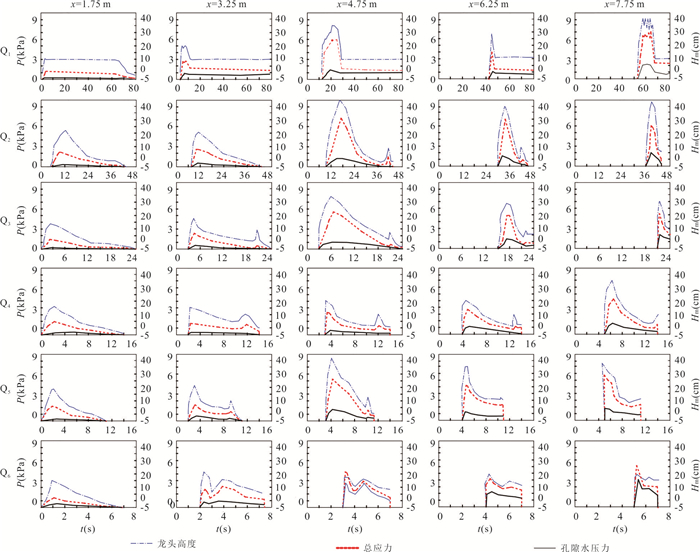
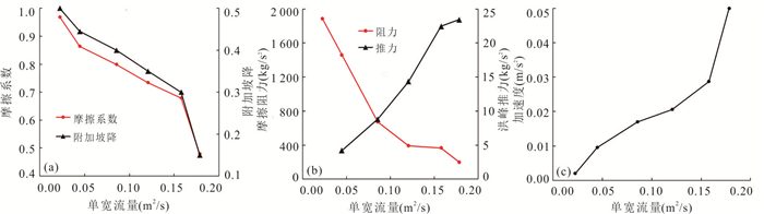
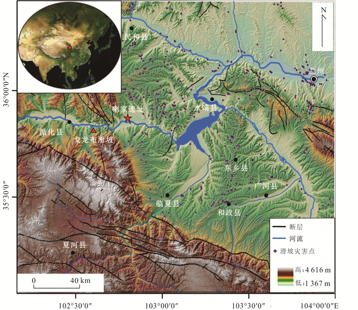
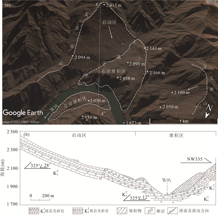
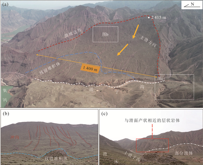
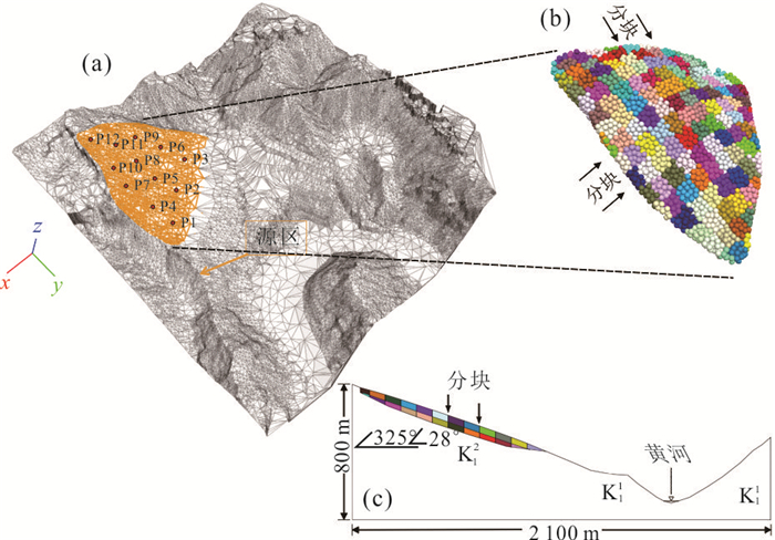
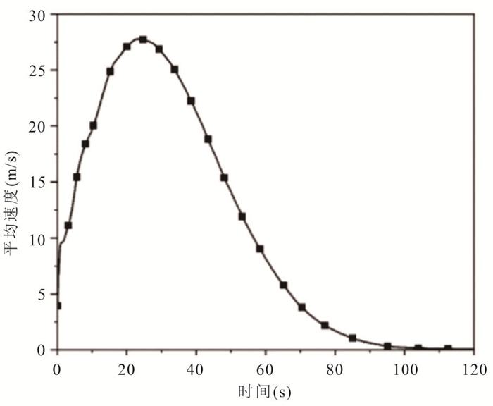
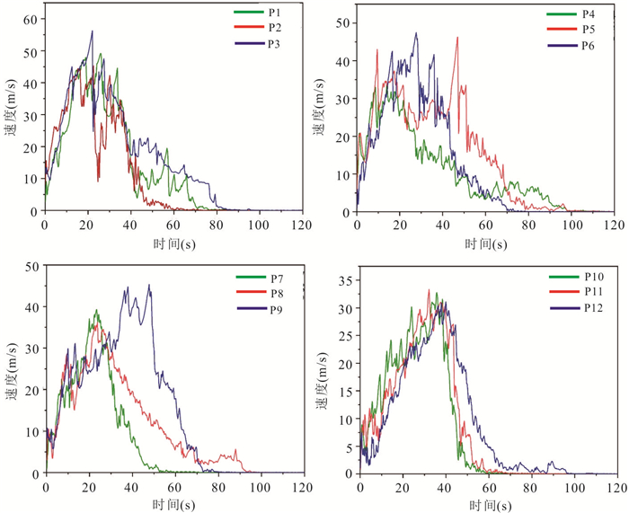
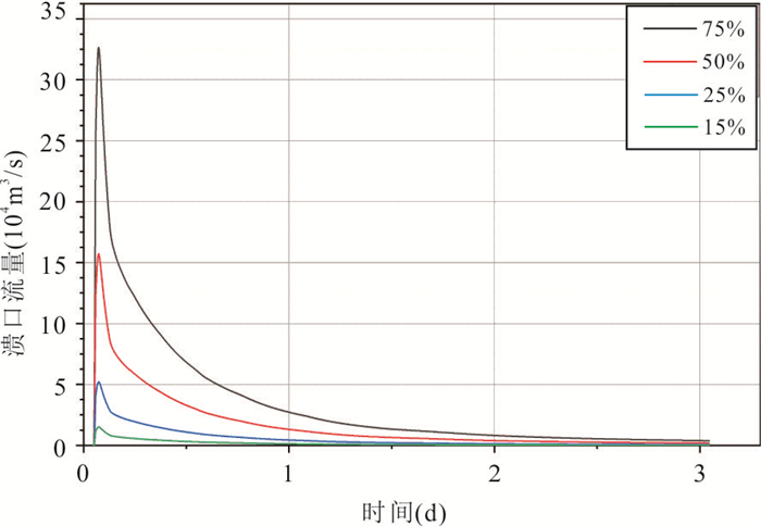
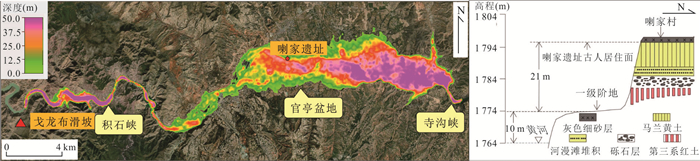
This paper takes the Holocene Gelongbu ancient landslide blocking the river outburst flood geological disaster chain as an example, using field surveys, PFC3D landslide dynamics numerical simulation and HEC-RAS outburst flood simulation to reproduce the whole process of the landslide slip-blocking-break disaster chain. It is found in field investigations that the total volume of Gelongbu landslide is about 7.92×10⁷ m3, the main sliding direction is NW335°, the maximum sliding distance is 2.3 km, and the maximum accumulation thickness is about 150 m. The materials at the front edge of the landslide are looser than those at the back edge, and the degree of fragmentation is higher. The numerical simulation shows that the sliding process of Gelongbu landslide lasts for 103 s, and the maximum velocity can reach 57 m/s. In the sliding process, the kinematic characteristics of the sliding process showed regional differences in the degree of fragmentation. Most of the particles maintained their original positions during the motion, and the accumulation material consisted of individual particles and block clusters with relatively weak fragmentation. The landslide blocked the Yellow River and formed a barrier dam as high as 143 m at the saddle point and elevations of 2 030 m on the left bank and 2 063 m on the right bank. The area of the landslide accumulation body is approximately 1.8×10⁶ m2, forming an upstream reservoir with an area of 128 km2 and a storage capacity of 4.87×10⁹ m3. By simulating the flood evolution process under different degrees of dam break (15%, 25%, 50%, and 75%), it was observed that the outflow from the breach rapidly increased to a peak within 30 minutes, followed by a gradual decrease in velocity. The peak outflow from the breach at different levels of dam break were 15 137.9 m3/s, 52 192.9 m3/s, 157 375.5 m3/s, and 326 703.6 m3/s, respectively. The peak flood discharge and water level characteristics at various downstream sections were analyzed. The relationship between flood evolution and the Lajia Site is discussed. It is found that the peak discharge of the burst flood is 57 782.3 m3/s when the dam breaks at 25%, and the water depth at the Lajia Site is 27.1 m, which is 6.1 m above the ancient surface of the site. When 75% of the dam breaks, the maximum flow to Erlitou Site was equivalent to the once-in-100-year flood flow of the Yellow River.
This paper takes the Holocene Gelongbu ancient landslide blocking the river outburst flood geological disaster chain as an example, using field surveys, PFC3D landslide dynamics numerical simulation and HEC-RAS outburst flood simulation to reproduce the whole process of the landslide slip-blocking-break disaster chain. It is found in field investigations that the total volume of Gelongbu landslide is about 7.92×10⁷ m3, the main sliding direction is NW335°, the maximum sliding distance is 2.3 km, and the maximum accumulation thickness is about 150 m. The materials at the front edge of the landslide are looser than those at the back edge, and the degree of fragmentation is higher. The numerical simulation shows that the sliding process of Gelongbu landslide lasts for 103 s, and the maximum velocity can reach 57 m/s. In the sliding process, the kinematic characteristics of the sliding process showed regional differences in the degree of fragmentation. Most of the particles maintained their original positions during the motion, and the accumulation material consisted of individual particles and block clusters with relatively weak fragmentation. The landslide blocked the Yellow River and formed a barrier dam as high as 143 m at the saddle point and elevations of 2 030 m on the left bank and 2 063 m on the right bank. The area of the landslide accumulation body is approximately 1.8×10⁶ m2, forming an upstream reservoir with an area of 128 km2 and a storage capacity of 4.87×10⁹ m3. By simulating the flood evolution process under different degrees of dam break (15%, 25%, 50%, and 75%), it was observed that the outflow from the breach rapidly increased to a peak within 30 minutes, followed by a gradual decrease in velocity. The peak outflow from the breach at different levels of dam break were 15 137.9 m3/s, 52 192.9 m3/s, 157 375.5 m3/s, and 326 703.6 m3/s, respectively. The peak flood discharge and water level characteristics at various downstream sections were analyzed. The relationship between flood evolution and the Lajia Site is discussed. It is found that the peak discharge of the burst flood is 57 782.3 m3/s when the dam breaks at 25%, and the water depth at the Lajia Site is 27.1 m, which is 6.1 m above the ancient surface of the site. When 75% of the dam breaks, the maximum flow to Erlitou Site was equivalent to the once-in-100-year flood flow of the Yellow River.


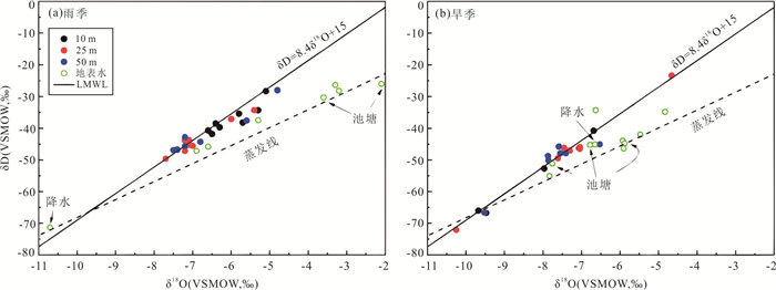
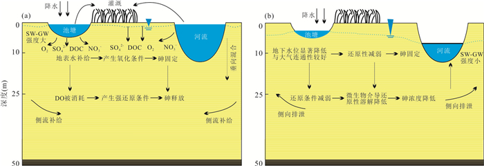
2023, 48(9): 3420-3431.
doi: 10.3799/dqkx.2022.146
Abstract:
Surface water-groundwater (SW-GW) interaction is critical for arsenic transport in shallow groundwater systems, but the role of its pattern and intensity on arsenic transport remains unclear. Field monitoring and numerical simulation were employed to identify the impact of surface water-groundwater interaction mode and intensity on arsenic transport in shallow groundwater of Shahu field site, Jianghan Plain. The results indicate that the surface water recharged into groundwater and had a relatively stronger intensity in the rainy season, which led to the higher arsenic concentration, and vice versa. The seasonal shift of surface water-groundwater interaction mode and intensity could cause the seasonal response of groundwater flow velocity and direction. It is estimated by the numerical simulation that the maximum vertical exchange mass of arsenic is 457.2 mg/d in rainy season and 191.3 mg/d in dry season and the maximum horizontal exchange mass of arsenic is 4 380.0 and 1 385.6 mg/d in rainy and dry season, respectively.
Surface water-groundwater (SW-GW) interaction is critical for arsenic transport in shallow groundwater systems, but the role of its pattern and intensity on arsenic transport remains unclear. Field monitoring and numerical simulation were employed to identify the impact of surface water-groundwater interaction mode and intensity on arsenic transport in shallow groundwater of Shahu field site, Jianghan Plain. The results indicate that the surface water recharged into groundwater and had a relatively stronger intensity in the rainy season, which led to the higher arsenic concentration, and vice versa. The seasonal shift of surface water-groundwater interaction mode and intensity could cause the seasonal response of groundwater flow velocity and direction. It is estimated by the numerical simulation that the maximum vertical exchange mass of arsenic is 457.2 mg/d in rainy season and 191.3 mg/d in dry season and the maximum horizontal exchange mass of arsenic is 4 380.0 and 1 385.6 mg/d in rainy and dry season, respectively.


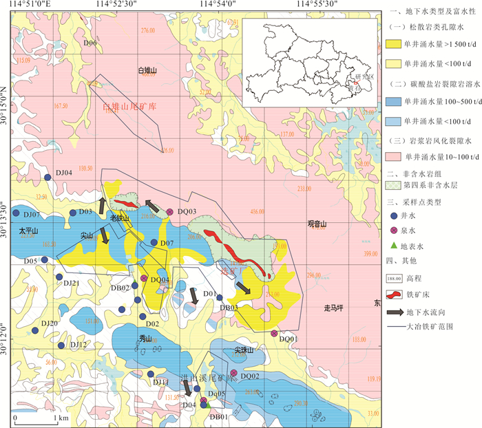
2023, 48(9): 3432-3443.
doi: 10.3799/dqkx.2022.119
Abstract:
Sulfate pollution of groundwater around copper and iron mining areas is a hot issue in ecological environment research. It is very important to identify the sources and migration routes of sulfate in the groundwater system for the prevention of groundwater pollution and the safety of water supply in the mining area. Combined with the hydrogeological setting and the distribution of potential pollutant sources in the mining area, the coupled analysis of hydrochemistry and δ34S-SO42‒ was carried to explore the characteristics, sources and migration pathways of groundwater sulfate pollution in the area. The results show that the groundwater in the area included the pore water in the sedimentary aquifers, the karst water of carbonatite and the fissure water of igneous rocks. The main hydrochemical type was HCO3·SO4-Ca. The formation of hydrochemical components mainly included the dissolution of silicate, carbonate and sulfate minerals, as well as the oxidation of sulfide. The content of SO42‒ ranged between 44.4 mg/L and 2 089.0 mg/L. The groundwater with elevated SO42‒ concentration occurred near the Hongshan River tailings reservoir, the slag heap and the industrial areas. The value of δ34S in regional groundwater ranged between 2.6‰ and 31.5‰, indicating that SO42‒ came from multiple sources. The sources of sulfate in groundwater included the dissolution of gypsum, the oxidation of sulfide such as pyrite. The maximum of SO42‒ attributed to the oxidization of pyrite. Mine drainage, tailing leakage, the settling of dust and wastewater infiltration were the main pathways of groundwater pollution.
Sulfate pollution of groundwater around copper and iron mining areas is a hot issue in ecological environment research. It is very important to identify the sources and migration routes of sulfate in the groundwater system for the prevention of groundwater pollution and the safety of water supply in the mining area. Combined with the hydrogeological setting and the distribution of potential pollutant sources in the mining area, the coupled analysis of hydrochemistry and δ34S-SO42‒ was carried to explore the characteristics, sources and migration pathways of groundwater sulfate pollution in the area. The results show that the groundwater in the area included the pore water in the sedimentary aquifers, the karst water of carbonatite and the fissure water of igneous rocks. The main hydrochemical type was HCO3·SO4-Ca. The formation of hydrochemical components mainly included the dissolution of silicate, carbonate and sulfate minerals, as well as the oxidation of sulfide. The content of SO42‒ ranged between 44.4 mg/L and 2 089.0 mg/L. The groundwater with elevated SO42‒ concentration occurred near the Hongshan River tailings reservoir, the slag heap and the industrial areas. The value of δ34S in regional groundwater ranged between 2.6‰ and 31.5‰, indicating that SO42‒ came from multiple sources. The sources of sulfate in groundwater included the dissolution of gypsum, the oxidation of sulfide such as pyrite. The maximum of SO42‒ attributed to the oxidization of pyrite. Mine drainage, tailing leakage, the settling of dust and wastewater infiltration were the main pathways of groundwater pollution.


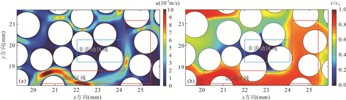
2023, 48(9): 3444-3453.
doi: 10.3799/dqkx.2021.166
Abstract:
The contaminant transport in porous media is crucial for a comprehensive understanding of groundwater contamination. However, there are still inadequacies in the research concerning the effect of the coefficient of variation (COV) of particle size of porous media on the contaminant transport in the internal microscopic pore structure. A method is proposed to construct a geometric model of porous media with different coefficients of variation and consistent porosity based on a random algorithm. The groundwater flow field and contaminant concentration field in porous media are obtained by coupling the Navier-Stokes equation and the advection-diffusion equation. The uniformity of flow velocity distribution is evaluated quantitatively by introducing Christiansen uniformity coefficient. Based on the MIM (mobile and immobile) model and the ADE (advection-dispersion equation) model, the characteristics of breakthrough curves are analyzed. The results show that as the COV of particle size increases, the non-uniformity of the flow velocity distribution is enhanced. The COV of particle size is positively correlated with the ratio of solute mobile domain\begin{document}$ \beta $\end{document} \begin{document}$ {\alpha }^{*} $\end{document} \begin{document}$ {E}_{\mathrm{i}} $\end{document}
The contaminant transport in porous media is crucial for a comprehensive understanding of groundwater contamination. However, there are still inadequacies in the research concerning the effect of the coefficient of variation (COV) of particle size of porous media on the contaminant transport in the internal microscopic pore structure. A method is proposed to construct a geometric model of porous media with different coefficients of variation and consistent porosity based on a random algorithm. The groundwater flow field and contaminant concentration field in porous media are obtained by coupling the Navier-Stokes equation and the advection-diffusion equation. The uniformity of flow velocity distribution is evaluated quantitatively by introducing Christiansen uniformity coefficient. Based on the MIM (mobile and immobile) model and the ADE (advection-dispersion equation) model, the characteristics of breakthrough curves are analyzed. The results show that as the COV of particle size increases, the non-uniformity of the flow velocity distribution is enhanced. The COV of particle size is positively correlated with the ratio of solute mobile domain


2023, 48(9): 3454-3465.
doi: 10.3799/dqkx.2021.135
Abstract:
Whether the groundwater pollution plume of a contaminated site or a regional area can be stabilized and the stability characteristics of the plume would directly determine the feasibility of the natural attenuation restoration. In this study, a typical aquifer structure with a phreatic aquifer, an impermeable aquifer, and a confined aquifer from top to bottom was constructed to simulate the migration and diffusion of the constant source pollution plume of phreatic water. The stable area, stable concentration and starting stable time of the groundwater pollution plume were taken as characteristic variables. Firstly, the sensitive factors were identified from numerous influence factors through sensitivity analysis method. Secondly, orthogonal experiments were used to identify the main controlling factors. Finally, the multiple regression model was used to construct the quantitative statistical relationship for characteristic variables. The results show that the common primary controlling factors are the degradation coefficient, dispersivity, seepage velocity and the source concentration. Moreover, there are adequate statistical relationships between the characteristic variables and the primary controlling factors. The statistical models characterized by different numbers of factors can be used to predict the characteristic variables. This study would provide an important basis for optimization of the site pollution control and effective remediation which are based on natural attenuation remediation.
Whether the groundwater pollution plume of a contaminated site or a regional area can be stabilized and the stability characteristics of the plume would directly determine the feasibility of the natural attenuation restoration. In this study, a typical aquifer structure with a phreatic aquifer, an impermeable aquifer, and a confined aquifer from top to bottom was constructed to simulate the migration and diffusion of the constant source pollution plume of phreatic water. The stable area, stable concentration and starting stable time of the groundwater pollution plume were taken as characteristic variables. Firstly, the sensitive factors were identified from numerous influence factors through sensitivity analysis method. Secondly, orthogonal experiments were used to identify the main controlling factors. Finally, the multiple regression model was used to construct the quantitative statistical relationship for characteristic variables. The results show that the common primary controlling factors are the degradation coefficient, dispersivity, seepage velocity and the source concentration. Moreover, there are adequate statistical relationships between the characteristic variables and the primary controlling factors. The statistical models characterized by different numbers of factors can be used to predict the characteristic variables. This study would provide an important basis for optimization of the site pollution control and effective remediation which are based on natural attenuation remediation.


2023, 48(9): 3466-3479.
doi: 10.3799/dqkx.2021.147
Abstract:
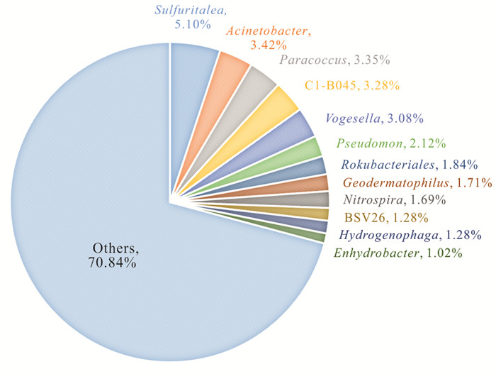
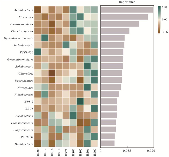
Conducting microbiological research in unique geological formations is of significant value, yet related studies within deep fluorine-rich groundwater environments remain insufficient. To dress this gap, 9 groundwater source well samples were collected from the 3rd hydrous group of Taocheng District of Hengshui City, China, and the water chemistry analysis and microbial 16S RNA gene V4-V5 region sequencing were performed. The results showed that the deep groundwater in the studied area was slightly alkaline with relatively low TDS and the average content of F‒ was 1.01 mg/L. The overall water chemistry types were characterized as Cl·SO4-Na and HCO3·Cl·SO4-Na types. The influence of F‒ content on the abundance and diversity of groundwater microorganisms was obvious, with 39 and 126 genera unique to high vs. low fluoride groundwater, respectively. Groundwater was dominated by Proteobacteria at the phylum level (47.67%-76.96%), with a high dispersion of taxa at the genus level and no obvious dominant genera. On the whole, the composition of the bacteria in groundwater of the study area is sensitive and strongly correlates with water chemical processes. NO3‒, F‒, DO and sampling depth are predominantly influence microbial composition, and DO also critically supports the microbial abundance levels in groundwater in the study area.
Conducting microbiological research in unique geological formations is of significant value, yet related studies within deep fluorine-rich groundwater environments remain insufficient. To dress this gap, 9 groundwater source well samples were collected from the 3rd hydrous group of Taocheng District of Hengshui City, China, and the water chemistry analysis and microbial 16S RNA gene V4-V5 region sequencing were performed. The results showed that the deep groundwater in the studied area was slightly alkaline with relatively low TDS and the average content of F‒ was 1.01 mg/L. The overall water chemistry types were characterized as Cl·SO4-Na and HCO3·Cl·SO4-Na types. The influence of F‒ content on the abundance and diversity of groundwater microorganisms was obvious, with 39 and 126 genera unique to high vs. low fluoride groundwater, respectively. Groundwater was dominated by Proteobacteria at the phylum level (47.67%-76.96%), with a high dispersion of taxa at the genus level and no obvious dominant genera. On the whole, the composition of the bacteria in groundwater of the study area is sensitive and strongly correlates with water chemical processes. NO3‒, F‒, DO and sampling depth are predominantly influence microbial composition, and DO also critically supports the microbial abundance levels in groundwater in the study area.


2023, 48(9): 3480-3493.
doi: 10.3799/dqkx.2021.149
Abstract:
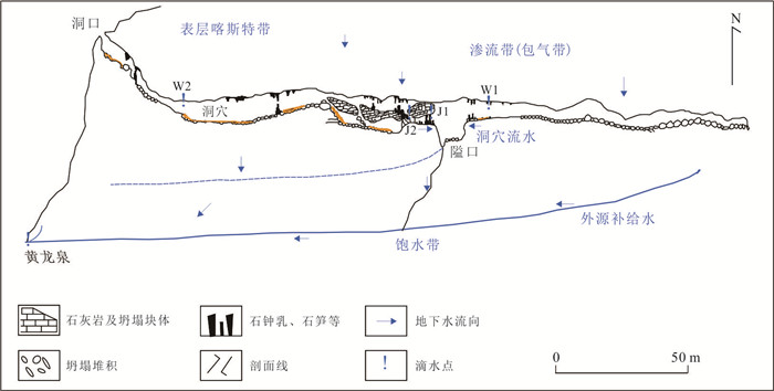
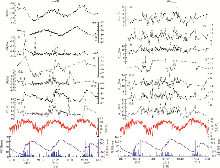
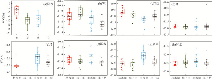
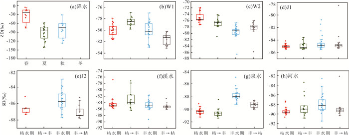
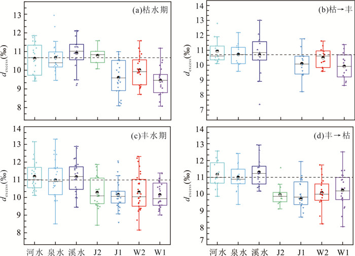
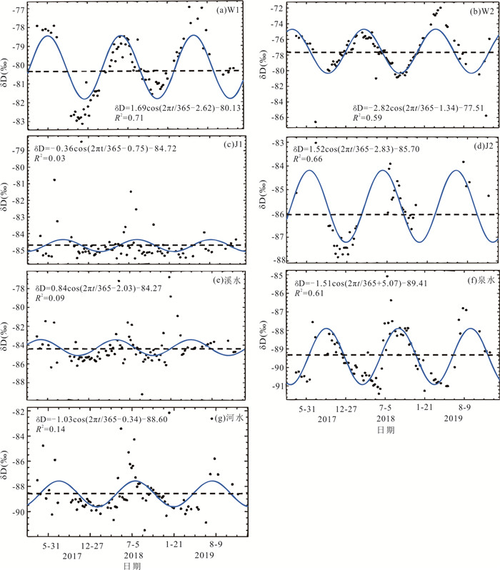
In order to explore the recharge mechanism of karst spring. Based on the data of hydrogen and oxygen stable isotopes monitored from April 2017 to December 2020 in Huanglong spring catchment monitored from April 2017 to December 2020, the models of unary linear regression, multiple linear regression, and trigonometric regression were used to explore the characteristics of hydrogen and oxygen stable isotopes, hydrology, and conductivity changes in the spring waters and their coupling relationships to reveal the process of spring recharge sources. The results show that: (1) The δD and δ18O values of spring water and river water were greater in the wet period than in the dry period, and the δD and δ18O values of cave drip water and stream water were similar to the stable isotope value of regional atmospheric precipitation, which were greater in the dry period than in the wet period. (2) The d-excess values of the spring catchment were greater in the wet period than in the dry period, and the water level, δD, δ18O and conductivity of the spring produced a seasonal coupling response to precipitation, and the recharge process of spring was influenced by the "piston effect" of the karst system and the "dilution effect" of the precipitation. (3) The seasonal characteristics of δD and δ18O of cave drips show that the drips inside the cave were larger than those near the cave entrance; the time sequence of troughs in the δD cosine function of the spring domain: stream water > cave drips > river water > spring water, and the response time to atmospheric precipitation was successively delayed. (4) The spring was recharged by the perennial mixture of infiltration of atmospheric precipitation and the weathering fissure water flowing from non-karst areas. The analyses of the characteristics of hydrogen and oxygen isotopes, hydrologic dynamics, runoff process and recharge mechanism in karst region have important reference significance for the control, management and protection of water resources in karst area.
In order to explore the recharge mechanism of karst spring. Based on the data of hydrogen and oxygen stable isotopes monitored from April 2017 to December 2020 in Huanglong spring catchment monitored from April 2017 to December 2020, the models of unary linear regression, multiple linear regression, and trigonometric regression were used to explore the characteristics of hydrogen and oxygen stable isotopes, hydrology, and conductivity changes in the spring waters and their coupling relationships to reveal the process of spring recharge sources. The results show that: (1) The δD and δ18O values of spring water and river water were greater in the wet period than in the dry period, and the δD and δ18O values of cave drip water and stream water were similar to the stable isotope value of regional atmospheric precipitation, which were greater in the dry period than in the wet period. (2) The d-excess values of the spring catchment were greater in the wet period than in the dry period, and the water level, δD, δ18O and conductivity of the spring produced a seasonal coupling response to precipitation, and the recharge process of spring was influenced by the "piston effect" of the karst system and the "dilution effect" of the precipitation. (3) The seasonal characteristics of δD and δ18O of cave drips show that the drips inside the cave were larger than those near the cave entrance; the time sequence of troughs in the δD cosine function of the spring domain: stream water > cave drips > river water > spring water, and the response time to atmospheric precipitation was successively delayed. (4) The spring was recharged by the perennial mixture of infiltration of atmospheric precipitation and the weathering fissure water flowing from non-karst areas. The analyses of the characteristics of hydrogen and oxygen isotopes, hydrologic dynamics, runoff process and recharge mechanism in karst region have important reference significance for the control, management and protection of water resources in karst area.


2023, 48(9): 3494-3503.
doi: 10.3799/dqkx.2023.046
Abstract:
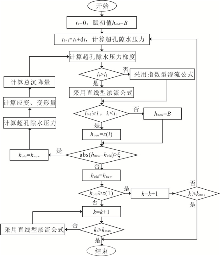
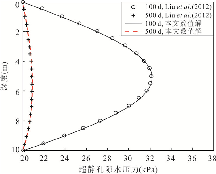
The slow seepage velocity in the aquitard is not conducive to monitoring its water release process, so the consolidation model is often used to comprehensively evaluate the evolution process of land subsidence. However, the traditional consolidation model assumes that the seepage law in the aquitard meets Darcy's law, which may be inconsistent with the actual situation. Therefore, a consolidation model considering the interface of moving non-Darcy flow region is established in this study, and the numerical solution of the model is established by using the finite difference method, in which the permeability coefficient and void ratio are assumed to be functions of stress. Compared with the existing models and indoor experimental data, the reliability of this research model is verified. The results show that the new model can more accurately simulate the consolidation process of aquitard induced by the instantaneous drawdown of water level. The consolidation model considering the moving non-Darcy flow interface delays the dissipation process of excess pore water pressure, but does not affect the total dissipation and total settlement of pore water pressure. For the consolidation model considering the attenuation of permeability coefficient, the time for the dissipation of pore water pressure and the settlement to reach the stability is obviously prolonged, and the variable permeability coefficient delays the time for the moving interface to reach the stability, causing the stable position of the moving interface to move upward.
The slow seepage velocity in the aquitard is not conducive to monitoring its water release process, so the consolidation model is often used to comprehensively evaluate the evolution process of land subsidence. However, the traditional consolidation model assumes that the seepage law in the aquitard meets Darcy's law, which may be inconsistent with the actual situation. Therefore, a consolidation model considering the interface of moving non-Darcy flow region is established in this study, and the numerical solution of the model is established by using the finite difference method, in which the permeability coefficient and void ratio are assumed to be functions of stress. Compared with the existing models and indoor experimental data, the reliability of this research model is verified. The results show that the new model can more accurately simulate the consolidation process of aquitard induced by the instantaneous drawdown of water level. The consolidation model considering the moving non-Darcy flow interface delays the dissipation process of excess pore water pressure, but does not affect the total dissipation and total settlement of pore water pressure. For the consolidation model considering the attenuation of permeability coefficient, the time for the dissipation of pore water pressure and the settlement to reach the stability is obviously prolonged, and the variable permeability coefficient delays the time for the moving interface to reach the stability, causing the stable position of the moving interface to move upward.


2023, 48(9): 3504-3517.
doi: 10.3799/dqkx.2021.144
Abstract:
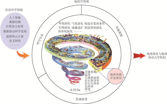
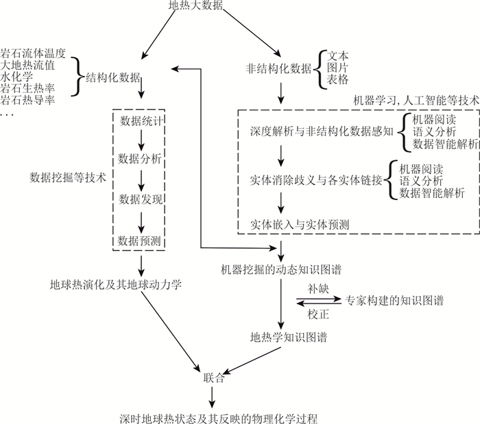
The era of big data drives the revolution of industry, thoughts, and science. The integration, induction, and scientific discovery of data bring opportunities and challenges to the development of geothermics. As a multi-disciplinary or interdisciplinary subject, geothermics involves all aspects of earth science, which poses challenges to the extremely complex and difficult development of geothermics in the era of big data. In this study, we divide geothermics into contemporary geothermics and historical geothermics based on time. First, we analyze the geothermal structure and related energy/disasters from three aspects of heat flow distribution in China and the world, hydrochemical parameters, and geothermal potential evaluation system. Second, we discuss the temporal and spatial changes of heat, the tectonic evolution, and the effect of climate, environment, and energy from three aspects of temporal and spatial variation, evolution, and resource formation of heat in historical geothermics. All these efforts aim to expound the foresight and feasibility of big data introduction, respectively. In the future, the development of geothermics should focus on the construction of the framework and elements of geothermics, the interpretation of related scientific links, and discovery. Meanwhile, it should focus on the construction of the knowledge graph of geothermics, the integration, interpretation, and discovery of multi-disciplinary knowledge, and the reconstruction of the deep-time geothermal state and physical and the chemical processes reflected.
The era of big data drives the revolution of industry, thoughts, and science. The integration, induction, and scientific discovery of data bring opportunities and challenges to the development of geothermics. As a multi-disciplinary or interdisciplinary subject, geothermics involves all aspects of earth science, which poses challenges to the extremely complex and difficult development of geothermics in the era of big data. In this study, we divide geothermics into contemporary geothermics and historical geothermics based on time. First, we analyze the geothermal structure and related energy/disasters from three aspects of heat flow distribution in China and the world, hydrochemical parameters, and geothermal potential evaluation system. Second, we discuss the temporal and spatial changes of heat, the tectonic evolution, and the effect of climate, environment, and energy from three aspects of temporal and spatial variation, evolution, and resource formation of heat in historical geothermics. All these efforts aim to expound the foresight and feasibility of big data introduction, respectively. In the future, the development of geothermics should focus on the construction of the framework and elements of geothermics, the interpretation of related scientific links, and discovery. Meanwhile, it should focus on the construction of the knowledge graph of geothermics, the integration, interpretation, and discovery of multi-disciplinary knowledge, and the reconstruction of the deep-time geothermal state and physical and the chemical processes reflected.


2023, 48(9): 3518-3525.
doi: 10.3799/dqkx.2022.330
Abstract:
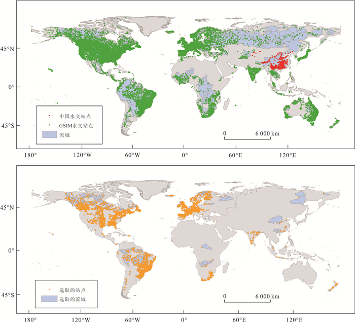
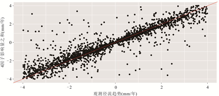
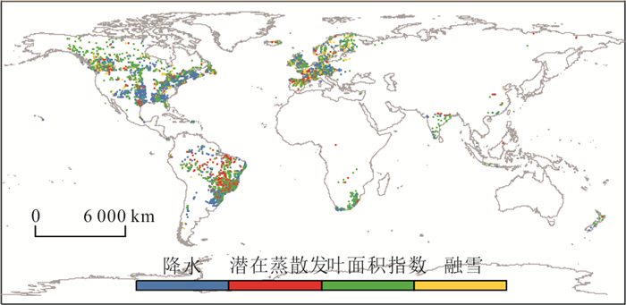
Limited by the available gauging hydrological data, most studies concerning streamflow change are restricted to the regional scale. By combining two streamflow datasets and extracting their corresponding meteorological data, we obtained the most complete global hydrometeorological dataset. Furthermore, we applied the Mann-Kendall test to examine the streamflow change at 4 469 global stations. Lastly, based on the random forest method, we developed an attribution framework to quantify the contributions of precipitation (P), potential evapotranspiration (PET), leaf area index (LAI) and snowmelt to observe streamflow change. The results indicate that the global streamflow change is mainly showing a decreasing trend, with 28.2% (9.7%) of global stations showing significantly decreasing (increasing) trends. For 42.2% of global stations, streamflow changes are dominated by the LAI, while P, PET, and snowmelt dominate 35.3%, 12.5%, and 10.0%, respectively.
Limited by the available gauging hydrological data, most studies concerning streamflow change are restricted to the regional scale. By combining two streamflow datasets and extracting their corresponding meteorological data, we obtained the most complete global hydrometeorological dataset. Furthermore, we applied the Mann-Kendall test to examine the streamflow change at 4 469 global stations. Lastly, based on the random forest method, we developed an attribution framework to quantify the contributions of precipitation (P), potential evapotranspiration (PET), leaf area index (LAI) and snowmelt to observe streamflow change. The results indicate that the global streamflow change is mainly showing a decreasing trend, with 28.2% (9.7%) of global stations showing significantly decreasing (increasing) trends. For 42.2% of global stations, streamflow changes are dominated by the LAI, while P, PET, and snowmelt dominate 35.3%, 12.5%, and 10.0%, respectively.


2023, 48(9): 3526-3538.
doi: 10.3799/dqkx.2021.218
Abstract:
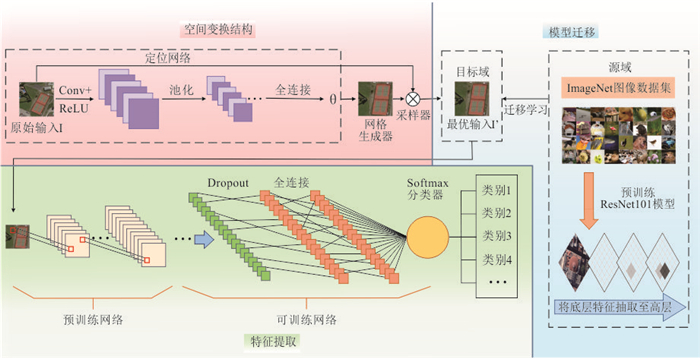
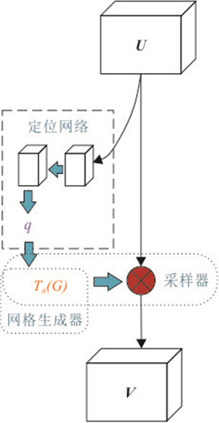
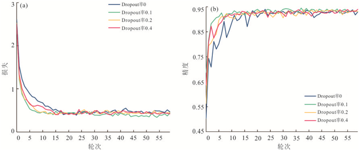
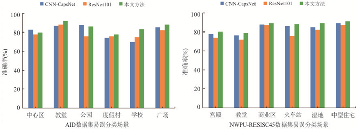
In order to solve the problem that the remote sensing image with small sample set can easily lead to the over-fitting of the training model and the low classification accuracy caused by the spatial invariance of convolution neural network in remote sensing image scene classification, a high-resolution remote sensing image scene classification algorithm based on spatial transformation network and transfer learning is proposed. Firstly, the ImageNet dataset is used to train the deep residual network ResNet101 to obtain the pre-training model, and the training efficiency of the model is improved through knowledge transfer. Then, the spatial transformation structure is embedded in the model, so that the model can actively transform the feature mapping in space and improve the robustness of the model. Finally, the Dropout layer is added to the model to reduce the probability of over-fitting of the model. This method is verified on two high-score remote sensing image data sets of AID and NWPU-RESISC45, and the classification accuracy of 94.30% and 93.63% is achieved in the case of only 20% training samples. The experimental results show that the improved model has better feature extraction ability and better classification results for misclassification scenarios.
In order to solve the problem that the remote sensing image with small sample set can easily lead to the over-fitting of the training model and the low classification accuracy caused by the spatial invariance of convolution neural network in remote sensing image scene classification, a high-resolution remote sensing image scene classification algorithm based on spatial transformation network and transfer learning is proposed. Firstly, the ImageNet dataset is used to train the deep residual network ResNet101 to obtain the pre-training model, and the training efficiency of the model is improved through knowledge transfer. Then, the spatial transformation structure is embedded in the model, so that the model can actively transform the feature mapping in space and improve the robustness of the model. Finally, the Dropout layer is added to the model to reduce the probability of over-fitting of the model. This method is verified on two high-score remote sensing image data sets of AID and NWPU-RESISC45, and the classification accuracy of 94.30% and 93.63% is achieved in the case of only 20% training samples. The experimental results show that the improved model has better feature extraction ability and better classification results for misclassification scenarios.


2023, 48(9): 3539-3551.
doi: 10.3799/dqkx.2022.268
Abstract:
To quantify the response relationships between different types of vegetation and drought, firstly, the dataset of normalized difference vegetation index (NDVI) with a resolution of 1 km in Inner Mongolia from 1982 to 2019 was obtained through regression model downscaling method and standardized precipitation evapotranspiration index (SPEI) was calculated for characterizing drought conditions. Then, the frequency domain technique of transfer function analysis (TFA) was used to explore the existence, intensity and time delay of the response of different types of vegetation changes to drought in eastern Inner Mongolia. It was found that the coherence between NDVI and SPEI of grassland, shrub, broad-leaved forest and coniferous forest was 0.44, 0.57, 0.31, 0.43, 0.60, 0.32, 0.30, 0.19, 0.14 and 0.20, 0.13, 0.10 on annual, 6 months and 3 months scales, respectively. The response intensity of NDVI of various types of vegetation to drought showed that the shrub was stronger than that of grassland. The following was broad-leaved forest. The response intensity of NDVI of coniferous forest was weakest. The lag times of the NDVI of grassland, shrub, broad-leaved forest and coniferous forest on drought at three time scales for were 31, 20, 12 days, 77, 28, 34 days, 120, 69, 57 days and 179, 103, 65 days, respectively. The results show that grassland and shrub have significant coherence with drought, strong response intensity and faster response speed. However, coniferous forest and broad-leaved forest have low coherence with drought, strong resistance to drought, long response time to drought and less affected by drought.
To quantify the response relationships between different types of vegetation and drought, firstly, the dataset of normalized difference vegetation index (NDVI) with a resolution of 1 km in Inner Mongolia from 1982 to 2019 was obtained through regression model downscaling method and standardized precipitation evapotranspiration index (SPEI) was calculated for characterizing drought conditions. Then, the frequency domain technique of transfer function analysis (TFA) was used to explore the existence, intensity and time delay of the response of different types of vegetation changes to drought in eastern Inner Mongolia. It was found that the coherence between NDVI and SPEI of grassland, shrub, broad-leaved forest and coniferous forest was 0.44, 0.57, 0.31, 0.43, 0.60, 0.32, 0.30, 0.19, 0.14 and 0.20, 0.13, 0.10 on annual, 6 months and 3 months scales, respectively. The response intensity of NDVI of various types of vegetation to drought showed that the shrub was stronger than that of grassland. The following was broad-leaved forest. The response intensity of NDVI of coniferous forest was weakest. The lag times of the NDVI of grassland, shrub, broad-leaved forest and coniferous forest on drought at three time scales for were 31, 20, 12 days, 77, 28, 34 days, 120, 69, 57 days and 179, 103, 65 days, respectively. The results show that grassland and shrub have significant coherence with drought, strong response intensity and faster response speed. However, coniferous forest and broad-leaved forest have low coherence with drought, strong resistance to drought, long response time to drought and less affected by drought.


2023, 48(9): 3552-3561.
doi: 10.3799/dqkx.2021.259
Abstract:
Hankou is one of the three towns of Wuhan. It is the center of politics, finance, commerce and trade, foreign exchanges and an important transportation hub in central China. It has been known as "the first flourishing place in Chu" since ancient times and is known both at home and abroad as "The Chicago of the East". Hankou is not an administrative unit of Wuhan, but an region roughly under the jurisdiction of three administrative areas including Jiangan District, Jianghan District and Qiaokou District. It has been widely recognized that the rise of Hankou depended on the advantages of geographical environment. Located in the hinterland of the Hanjiang River estuary area, Hankou is an interaction area between the Yangtze River and the Hanjiang River. The geographical environment is changeable, the space-time evolution is complex, and there are different geographical patterns in different periods. Based on the Whole Map of Hanyang Prefecture in 1669 and other documents, this paper restores the ancient geography of Hankou during the reign of Kangxi in the Qing Dynasty. It is found that there were three rivers in Hankou area at that time, namely, Yudai River, Xianghe River and Lunhe River, which had the characteristics of "integrating rivers and lakes". Along the river, there were tall natural levees, which became the main geomorphic unit for the ancestors to live. Hanjiang River diverts from the east of Chengtou mountain in Caidian, which has 5 branch channels. During that period, the peak of the estuary distributary area of Hanjiang River the peak of the Hanjiang River estuary delta was near Chengtou Mountain, and the range of the estuary distributary area of Hanjiang River the Hanjiang River estuary delta was roughly within the boundary area of Chengtou Mountain-Shenjiaji-Xiaojun Mountain. Hankou Town was located between the Hanjiang River and the Yudai River, that is, within the enclosure dike formed by the natural levee of the Hanjiang River and the Yuangong Dike. The town and its public cultural buildings reflect the prosperity of Hankou Town at that time. The settlements outside Hankou Town were mainly concentrated on the natural levee, which lasted until the construction of Zhanggong Dike in the early 20th century. This study reveals for the first time the pattern of Hankou paleogeography in the Kangxi period of Qing Dynasty, which is of great significance to the understanding of the historical paleogeography evolution of Wuhan and the relationship between man and land. At the same time, it has certain reference value to the study of human settlement paleogeography in inland river estuary area and the geographical background of the rise of city.
Hankou is one of the three towns of Wuhan. It is the center of politics, finance, commerce and trade, foreign exchanges and an important transportation hub in central China. It has been known as "the first flourishing place in Chu" since ancient times and is known both at home and abroad as "The Chicago of the East". Hankou is not an administrative unit of Wuhan, but an region roughly under the jurisdiction of three administrative areas including Jiangan District, Jianghan District and Qiaokou District. It has been widely recognized that the rise of Hankou depended on the advantages of geographical environment. Located in the hinterland of the Hanjiang River estuary area, Hankou is an interaction area between the Yangtze River and the Hanjiang River. The geographical environment is changeable, the space-time evolution is complex, and there are different geographical patterns in different periods. Based on the Whole Map of Hanyang Prefecture in 1669 and other documents, this paper restores the ancient geography of Hankou during the reign of Kangxi in the Qing Dynasty. It is found that there were three rivers in Hankou area at that time, namely, Yudai River, Xianghe River and Lunhe River, which had the characteristics of "integrating rivers and lakes". Along the river, there were tall natural levees, which became the main geomorphic unit for the ancestors to live. Hanjiang River diverts from the east of Chengtou mountain in Caidian, which has 5 branch channels. During that period, the peak of the estuary distributary area of Hanjiang River the peak of the Hanjiang River estuary delta was near Chengtou Mountain, and the range of the estuary distributary area of Hanjiang River the Hanjiang River estuary delta was roughly within the boundary area of Chengtou Mountain-Shenjiaji-Xiaojun Mountain. Hankou Town was located between the Hanjiang River and the Yudai River, that is, within the enclosure dike formed by the natural levee of the Hanjiang River and the Yuangong Dike. The town and its public cultural buildings reflect the prosperity of Hankou Town at that time. The settlements outside Hankou Town were mainly concentrated on the natural levee, which lasted until the construction of Zhanggong Dike in the early 20th century. This study reveals for the first time the pattern of Hankou paleogeography in the Kangxi period of Qing Dynasty, which is of great significance to the understanding of the historical paleogeography evolution of Wuhan and the relationship between man and land. At the same time, it has certain reference value to the study of human settlement paleogeography in inland river estuary area and the geographical background of the rise of city.


2023, 48(9): 3562-3576.
doi: 10.3799/dqkx.2021.125
Abstract:
Glacial lacustrine deposit has high-resolution sedimentary records, which has great geological significance. The Quaternary glacial and interglacial events can be recorded by the lacustrine deposit. The Litang Plateau, located in the southeastern margin of the Qinghai-Tibetan Plateau, is the transition zone with the most significant terrain changes in China, and it has well developed glacial landform. A continuous 16 m-thick lacustrine section is measured in the Maoya Basin, western side of the Litang Plateau, which is formed in a glacial-dammed lake. It is composed of laminated mud and silty sand layers, and the soft-sediment deformation structures at the depth ranging from 12.68 to13.26 m were triggered by earthquake events. The main structures of the pliable sediment deformation include liquefied curling deformed layer, ball-pillow structure, liquefied diapir and interlayer slipping fold deformation, morphologically. Based on the AMS 14C radionuclide dating, the age interval is obtained at 33 850-33 110 cal. BP and 37 254-36 042 cal. BP. It indicates that at least two paleoseismic events occurred in this area during ± 37-33 ka. The earlier event occurred before 37-36 ka with magnitude above 7, and the later event occurred after 33 ka, with magnitude of around 6-7.
Glacial lacustrine deposit has high-resolution sedimentary records, which has great geological significance. The Quaternary glacial and interglacial events can be recorded by the lacustrine deposit. The Litang Plateau, located in the southeastern margin of the Qinghai-Tibetan Plateau, is the transition zone with the most significant terrain changes in China, and it has well developed glacial landform. A continuous 16 m-thick lacustrine section is measured in the Maoya Basin, western side of the Litang Plateau, which is formed in a glacial-dammed lake. It is composed of laminated mud and silty sand layers, and the soft-sediment deformation structures at the depth ranging from 12.68 to13.26 m were triggered by earthquake events. The main structures of the pliable sediment deformation include liquefied curling deformed layer, ball-pillow structure, liquefied diapir and interlayer slipping fold deformation, morphologically. Based on the AMS 14C radionuclide dating, the age interval is obtained at 33 850-33 110 cal. BP and 37 254-36 042 cal. BP. It indicates that at least two paleoseismic events occurred in this area during ± 37-33 ka. The earlier event occurred before 37-36 ka with magnitude above 7, and the later event occurred after 33 ka, with magnitude of around 6-7.