2024 Vol. 49, No. 1
Display Method:
2024, 49(1): 1-28.
doi: 10.3799/dqkx.2023.215
 PDF 14072KB
Abstract:
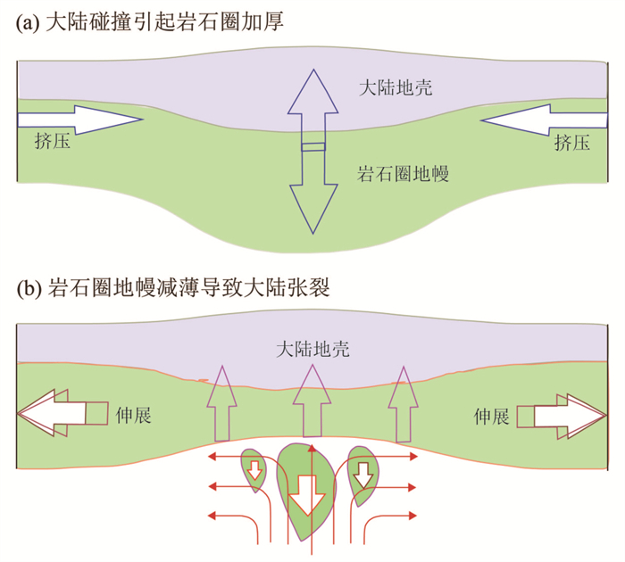
Anatectic metamorphism develops from high-grade metamorphism to crustal anataxis, marking population of extensional tectonism in continental collision zones. It is much more related to breakup than assembly of supercontinents in both space and time.Deciphering the anatectic metamorphism is critical to understand the tectonic evolution of continental collision zones in the late stage. It is substantial to resolve not only petrological problems such as crustal differentiation and granite petrogenesis but also tectonic problems such as supercontinent geodynamics in Wilson cycles. In general, continental collision zones may change their dynamic regime from compression to extension and their geothermal gradient from low to high during their evolution from the early to late stages. This results in different types of metamorphism and magmatism with given occurrences in both time and space. Alpine type metamorphism is caused by compressional heating at low geothermal gradients during subduction of one lithosphere beneath the others, and Barrovian type metamorphism occurs at moderate geothermal gradients due either to compressional heating during collisional thickening of the crust or to extensional decompression during nearly isothermal exhumation of the deeply subducted crust. In contrast, Buchan type metamorphism is caused by extensional heating at high geothermal gradients during continental rifting. Because of the anatectic metamorphism, granites are produced together with migmatites and granulites in the post-collisional stage. Therefore, granitic magmatism is the endmember product of anatectic metamorphism consequential to thinning of the thickened lithospheric mantle. Both processes are closely associated with the change of lithospheric thickness along continental collision zones. Although granites above oceanic subduction zone are mainly produced by fractional crystallization of mantle-derived mafic magmas, partial melting of crustal rocks is the dominant way to generate granitic magmas in continental collision zones. In particular, the source nature of crustal rocks is a key to the composition of granites. Ⅰ-type and S-type granites are primarily derived from partial melting of metaigneous and metasedimentary rocks, respectively. In comparison, A-type granites are derived from partial melting of either cumulates or restites. Dehydration and hydration melting are two fundamental mechanisms to produce granitic magmas. They can occur simultaneously at the same zones, leading to dehydration melting in the deeper crust and hydration melting in the shallower crust. Upwelling of the asthenospheric mantle consequential to thinning of the lithospheric mantle is a common geodynamic mechanism for continental active rifting, giving rise to the dehydration-hydration coupled melting to produce granite-migmatite-granulite associations in continental collision zones. As a consequence, supercontinent assembly is associated with compressional metamorphism during continental collision, whereas supercontinent breakup is associated with extensional metamorphism during active rifting. Continent rifting may not succeed but fail, resulting in anatectic metamorphism and granitic magmatism at convergent plate margins. Therefore, the failed continental rifting is a key process in linking the types of regional metamorphism to the tectonic evolution of continental collision zones from supercontinent assembly to breakup.
Anatectic metamorphism develops from high-grade metamorphism to crustal anataxis, marking population of extensional tectonism in continental collision zones. It is much more related to breakup than assembly of supercontinents in both space and time.Deciphering the anatectic metamorphism is critical to understand the tectonic evolution of continental collision zones in the late stage. It is substantial to resolve not only petrological problems such as crustal differentiation and granite petrogenesis but also tectonic problems such as supercontinent geodynamics in Wilson cycles. In general, continental collision zones may change their dynamic regime from compression to extension and their geothermal gradient from low to high during their evolution from the early to late stages. This results in different types of metamorphism and magmatism with given occurrences in both time and space. Alpine type metamorphism is caused by compressional heating at low geothermal gradients during subduction of one lithosphere beneath the others, and Barrovian type metamorphism occurs at moderate geothermal gradients due either to compressional heating during collisional thickening of the crust or to extensional decompression during nearly isothermal exhumation of the deeply subducted crust. In contrast, Buchan type metamorphism is caused by extensional heating at high geothermal gradients during continental rifting. Because of the anatectic metamorphism, granites are produced together with migmatites and granulites in the post-collisional stage. Therefore, granitic magmatism is the endmember product of anatectic metamorphism consequential to thinning of the thickened lithospheric mantle. Both processes are closely associated with the change of lithospheric thickness along continental collision zones. Although granites above oceanic subduction zone are mainly produced by fractional crystallization of mantle-derived mafic magmas, partial melting of crustal rocks is the dominant way to generate granitic magmas in continental collision zones. In particular, the source nature of crustal rocks is a key to the composition of granites. Ⅰ-type and S-type granites are primarily derived from partial melting of metaigneous and metasedimentary rocks, respectively. In comparison, A-type granites are derived from partial melting of either cumulates or restites. Dehydration and hydration melting are two fundamental mechanisms to produce granitic magmas. They can occur simultaneously at the same zones, leading to dehydration melting in the deeper crust and hydration melting in the shallower crust. Upwelling of the asthenospheric mantle consequential to thinning of the lithospheric mantle is a common geodynamic mechanism for continental active rifting, giving rise to the dehydration-hydration coupled melting to produce granite-migmatite-granulite associations in continental collision zones. As a consequence, supercontinent assembly is associated with compressional metamorphism during continental collision, whereas supercontinent breakup is associated with extensional metamorphism during active rifting. Continent rifting may not succeed but fail, resulting in anatectic metamorphism and granitic magmatism at convergent plate margins. Therefore, the failed continental rifting is a key process in linking the types of regional metamorphism to the tectonic evolution of continental collision zones from supercontinent assembly to breakup.


2024, 49(1): 29-39.
doi: 10.3799/dqkx.2022.113
Abstract:
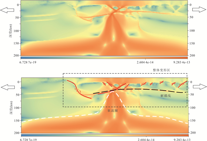
The Baikal rift is located in the convergent zone of the Siberian craton and Sayan-Baikal belt. There are obvious differences in the lithospheric structure and rheological property between the two sides of the rift, and the regional tectonic evolution is complex. Here it investigate the influence of rheological property of the lower crust and preexisting weak zone on the evolution of the Baikal rift using numerical simulation. The results show that the difference in the rheology of the lower crust on both sides of the rift extension center leads to the propagation of stress to the Sayan-Baikal belt, in which large-scale listric faults mainly develop on the Sayan-Baikal belt side, while small-scale high-angle normal faults mainly develop on the cratonic side. If there is a weak zone in the suture zone of lithosphere, the transfer of stress to the side of the Sayan-Baikal belt is limited, resulting in a reduced scale of faulting on the side of Sayan-Baikal belt, and the development of the asymmetric structure of "narrow and deep depression".
The Baikal rift is located in the convergent zone of the Siberian craton and Sayan-Baikal belt. There are obvious differences in the lithospheric structure and rheological property between the two sides of the rift, and the regional tectonic evolution is complex. Here it investigate the influence of rheological property of the lower crust and preexisting weak zone on the evolution of the Baikal rift using numerical simulation. The results show that the difference in the rheology of the lower crust on both sides of the rift extension center leads to the propagation of stress to the Sayan-Baikal belt, in which large-scale listric faults mainly develop on the Sayan-Baikal belt side, while small-scale high-angle normal faults mainly develop on the cratonic side. If there is a weak zone in the suture zone of lithosphere, the transfer of stress to the side of the Sayan-Baikal belt is limited, resulting in a reduced scale of faulting on the side of Sayan-Baikal belt, and the development of the asymmetric structure of "narrow and deep depression".


2024, 49(1): 40-54.
doi: 10.3799/dqkx.2022.209
Abstract:
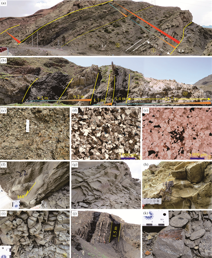
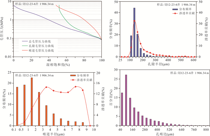
The concomitant source-reservoir is developed in the Upper Triassic Taliqike Formation of Kuqa depression, Tarim Basin. However, it has not yet attracted much attention for exploration and relevant studies on the reservoir have not been initiated. Based on the comprehensive analysis of sedimentary characteristics, physical property testing, and thin section identification, results of this study show that Taliqike Formation presents a "sandwich" of source-reservoir interbeds due to the alternation of sand/glutenite stone and dark mudstone or coal seams. The compositional maturity of sandstone is low, mainly composed of lithic sandstone, but as the particles become coarser, the quartz content tends to increase. Sandstone is in the middle diagenetic stage, and the most important pore reducing effect and the most obvious pore increasing effect are compaction and dissolution, respectively. The type of storage space is mainly intragranular dissolved pores and intergranular dissolved pores, and dissolution is the main contribution of the sandstone reservoir space of the Taliqike Formation. As the content of quartz particles increases the porosity tends to increase, and as the grain size of the sandstone becomes coarser, the porosity and permeability tend to become better; sedimentary facies is the key factor to control the reservoir and the sandstone/glutenite of distributary channel is the best reservoir. The physical properties of the sandstone of Taliqike Formation are similar to other important hydrocarbon reservoirs of Bashijiqike and Ahe Formations. The thicker Type Ⅱ-Ⅲ large-scale reservoirs are developed in the northern structural belt, and they are sandwiched in high-quality hydrocarbon source rocks formed by coal seams and dark mudstones. It is of great significance to search for middle-deep conventional and unconventional structure-lithologic reservoirs.
The concomitant source-reservoir is developed in the Upper Triassic Taliqike Formation of Kuqa depression, Tarim Basin. However, it has not yet attracted much attention for exploration and relevant studies on the reservoir have not been initiated. Based on the comprehensive analysis of sedimentary characteristics, physical property testing, and thin section identification, results of this study show that Taliqike Formation presents a "sandwich" of source-reservoir interbeds due to the alternation of sand/glutenite stone and dark mudstone or coal seams. The compositional maturity of sandstone is low, mainly composed of lithic sandstone, but as the particles become coarser, the quartz content tends to increase. Sandstone is in the middle diagenetic stage, and the most important pore reducing effect and the most obvious pore increasing effect are compaction and dissolution, respectively. The type of storage space is mainly intragranular dissolved pores and intergranular dissolved pores, and dissolution is the main contribution of the sandstone reservoir space of the Taliqike Formation. As the content of quartz particles increases the porosity tends to increase, and as the grain size of the sandstone becomes coarser, the porosity and permeability tend to become better; sedimentary facies is the key factor to control the reservoir and the sandstone/glutenite of distributary channel is the best reservoir. The physical properties of the sandstone of Taliqike Formation are similar to other important hydrocarbon reservoirs of Bashijiqike and Ahe Formations. The thicker Type Ⅱ-Ⅲ large-scale reservoirs are developed in the northern structural belt, and they are sandwiched in high-quality hydrocarbon source rocks formed by coal seams and dark mudstones. It is of great significance to search for middle-deep conventional and unconventional structure-lithologic reservoirs.


2024, 49(1): 55-70.
doi: 10.3799/dqkx.2022.171
Abstract:
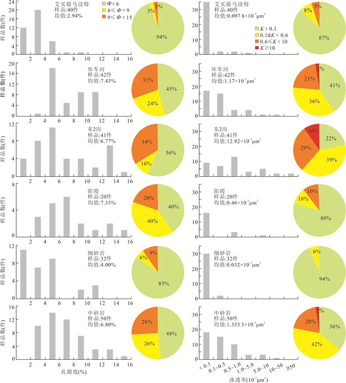
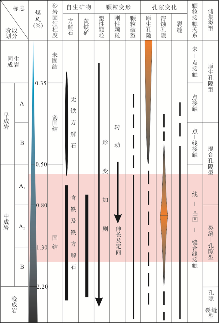
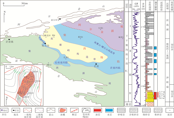
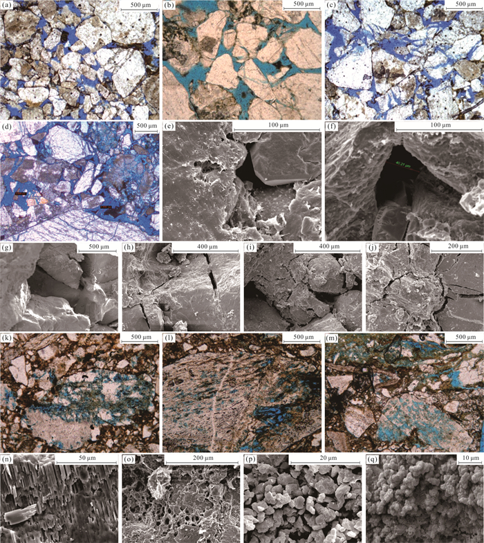
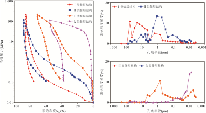
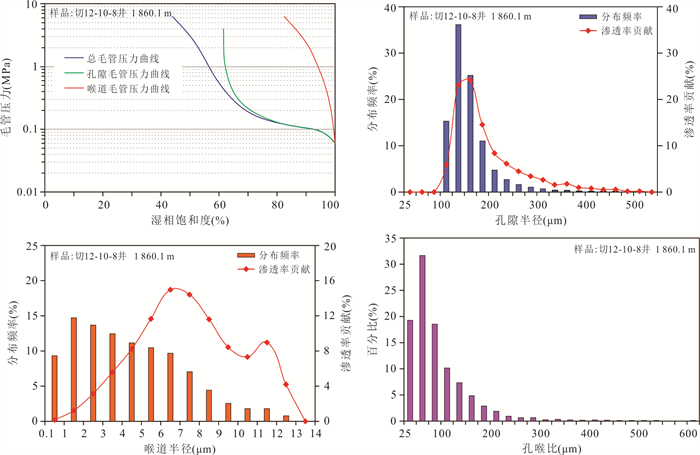
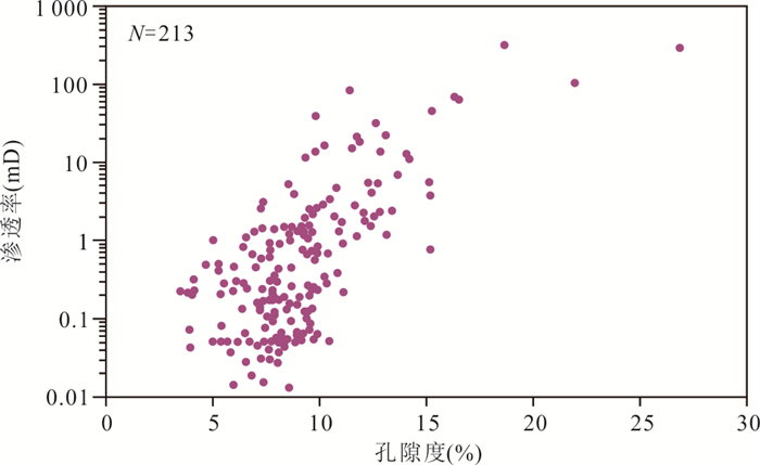
The Kunbei thrust belt of Qaidam Basin is a large piedmont compression-torsion thrust belt. On the belt, the thick sandy conglomerate reservoir formed in alluvial fan is developed in the lower member of the lower Ganchaigou Formation in Qie12 block of Kunbei Oilfield. Understanding of the microcosmic characteristics and the main development controlling factors of this sandy conglomerate reservoir is significant to reservoir evaluation and the comprehensive reservoir management. In this study, the microcosmic characteristics of alluvial fan sandy conglomerate reservoir were systematically studied by using casting thin sections, XRD, SEM, conventional mercury injection and constant velocity mercury injection, and the main controlling factors of reservoir development were identified. The results show that the sandy conglomerate reservoirs in the area have the petrological characteristics of low compositional maturity and low structural maturity. The reservoir space type is characterized by dual porosity medium. There are 2 types of reservoir structure modes, 4 types of reservoir space types and 4 types of reservoir pore structures. The reservoir is of low porosity, ultra-low permeability and early diagenesis stage B. Under the same geological background of reservoir dynamic diagenesis, the influence of diagenesis on reservoir reconstruction is relatively balanced. The difference of reservoir development degree is mainly controlled by the difference of clastic composition and structure caused by the difference of sedimentation. The shale content is the main controlling factor of the reservoir development degree, and the upper limit of the shale content for reservoir is 8%, while the particle sorting plays an important role in controlling the reservoir properties. The reservoir classification standard based on shale content, physical property, pore structure and productivity index was established, and the sandy conglomerate reservoir was divided into four types. The research findings have guided the comprehensive reservoir management and achieved practical application results.
The Kunbei thrust belt of Qaidam Basin is a large piedmont compression-torsion thrust belt. On the belt, the thick sandy conglomerate reservoir formed in alluvial fan is developed in the lower member of the lower Ganchaigou Formation in Qie12 block of Kunbei Oilfield. Understanding of the microcosmic characteristics and the main development controlling factors of this sandy conglomerate reservoir is significant to reservoir evaluation and the comprehensive reservoir management. In this study, the microcosmic characteristics of alluvial fan sandy conglomerate reservoir were systematically studied by using casting thin sections, XRD, SEM, conventional mercury injection and constant velocity mercury injection, and the main controlling factors of reservoir development were identified. The results show that the sandy conglomerate reservoirs in the area have the petrological characteristics of low compositional maturity and low structural maturity. The reservoir space type is characterized by dual porosity medium. There are 2 types of reservoir structure modes, 4 types of reservoir space types and 4 types of reservoir pore structures. The reservoir is of low porosity, ultra-low permeability and early diagenesis stage B. Under the same geological background of reservoir dynamic diagenesis, the influence of diagenesis on reservoir reconstruction is relatively balanced. The difference of reservoir development degree is mainly controlled by the difference of clastic composition and structure caused by the difference of sedimentation. The shale content is the main controlling factor of the reservoir development degree, and the upper limit of the shale content for reservoir is 8%, while the particle sorting plays an important role in controlling the reservoir properties. The reservoir classification standard based on shale content, physical property, pore structure and productivity index was established, and the sandy conglomerate reservoir was divided into four types. The research findings have guided the comprehensive reservoir management and achieved practical application results.


2024, 49(1): 71-83.
doi: 10.3799/dqkx.2022.334
Abstract:
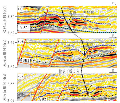
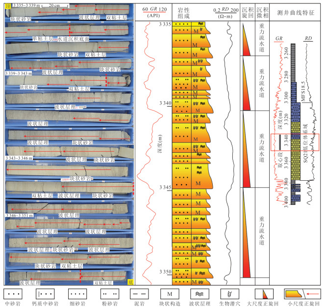
Recently increasingly-identified shallow marine fans and bottom current-reworking processes, which bought challenge on traditional knowledge such as the item of deep-water fan and Bouma Sequence, are needed for further research. The Baiyun Sag of Pearl River Mouth Basin is an important area for oil and gas exploration of submarine fans. The Miocene sequence SQ21 in this sag, whose base was dated as 21 Ma, is the main stratum hosting sandy submarine fans and petroleum discoveries, so was taken as the object in this study. Integrating core observation with analyses of well logging motifs, seismic reflection configurations and seismic geomorphology, this study revealed a large number of submarine fans in the falling stage and lowstand systems tracts of SQ21. The fans are constructed by gravity flow channels, levees and sheet lobes, corresponding to high-amplitude strips and lobate shapes, respectively, in seismic root mean square amplitude attribute maps. At the upper continental slope, the channels were deposited with mainly massive medium- to fine-grained sandstone and ripple-laminated fine-grained sandstone to siltstone, presenting upward-fining successions. They are characterized by cylindrical- to bell-shaped logging motifs, channel-infilling seismic reflections. Further, ripple-laminated sandstone to siltstone is intercalated with a lot of mudstone laminae partly illustrating single-clay and double-clay structures. This, together with abundant biological burrows, disturbance structure and siderite nodule, indicates that sea level greatly fell below shelf break. Consequently, the sandy submarine fan deposits, which were generated with their gravity flow channels at the upper continental slope, had been severely reworked by tide current, while shallow sea environment gradually occurred at the upper continental slope along with sea level greatly falling till below the shelf break. In this study, the application of seismic geomorphological analyses guarantees correct identification of the tidal current-reworked submarine fans. Moreover, it is suggested that the Bouma Sequence can be resulted from bottom current-reworking processes, and term of deep-water fan should not be overused.
Recently increasingly-identified shallow marine fans and bottom current-reworking processes, which bought challenge on traditional knowledge such as the item of deep-water fan and Bouma Sequence, are needed for further research. The Baiyun Sag of Pearl River Mouth Basin is an important area for oil and gas exploration of submarine fans. The Miocene sequence SQ21 in this sag, whose base was dated as 21 Ma, is the main stratum hosting sandy submarine fans and petroleum discoveries, so was taken as the object in this study. Integrating core observation with analyses of well logging motifs, seismic reflection configurations and seismic geomorphology, this study revealed a large number of submarine fans in the falling stage and lowstand systems tracts of SQ21. The fans are constructed by gravity flow channels, levees and sheet lobes, corresponding to high-amplitude strips and lobate shapes, respectively, in seismic root mean square amplitude attribute maps. At the upper continental slope, the channels were deposited with mainly massive medium- to fine-grained sandstone and ripple-laminated fine-grained sandstone to siltstone, presenting upward-fining successions. They are characterized by cylindrical- to bell-shaped logging motifs, channel-infilling seismic reflections. Further, ripple-laminated sandstone to siltstone is intercalated with a lot of mudstone laminae partly illustrating single-clay and double-clay structures. This, together with abundant biological burrows, disturbance structure and siderite nodule, indicates that sea level greatly fell below shelf break. Consequently, the sandy submarine fan deposits, which were generated with their gravity flow channels at the upper continental slope, had been severely reworked by tide current, while shallow sea environment gradually occurred at the upper continental slope along with sea level greatly falling till below the shelf break. In this study, the application of seismic geomorphological analyses guarantees correct identification of the tidal current-reworked submarine fans. Moreover, it is suggested that the Bouma Sequence can be resulted from bottom current-reworking processes, and term of deep-water fan should not be overused.


2024, 49(1): 84-102.
doi: 10.3799/dqkx.2022.213
Abstract:
Through the analysis of the paleogeographic environment and evolution of Permian volcanic eruptions in Southwest Sichuan, the paleogeographic location and distribution of paleolands during volcanic eruptions were analyzed, so as to delineate the distribution of favorable reservoirs. Based on a series of markers representing the eruption paleogeographic environment in volcanic rocks, combined with the analysis of indoor geochemistry, well logging data and karst paleogeomorphology before volcanic eruption, it is considered that there are two types of paleogeographic environment of volcanic eruption in this area: marine and continental. In the early stage of volcanic eruption, strong tectonic movement occurred in the second episode of the Soochow movement, which led to the formation of the Kangdian ancient land. The sea water retreated from Shimian-Tianquan area to the north and south. The marine sedimentary environment was only retained in the south of Shimian-Hanyuan-Ebian-Gongquan line in the south of the study area and the north of Baoxing in the north. In the middle-late period, Baoxing and its north inherited the early carbonate platform sedimentary environment, and the Ganluo-Mabian-Yanjin area evolved from gentle slope sedimentary environment to shore sedimentary environment. During the Permian volcanic eruption, Southwest Sichuan was an ancient land. The fused tuff and fused breccia developed in Chengdu-Jianyang area, with developed dissolution holes and the best reservoir, is an important target layer for Permian volcanic exploration in Sichuan Basin. Self broken breccia developed in Zhougongshan-Yibin area is the better reservoir because the weathering and leaching during the intermittent period of volcanic eruption produced dissolution holes since it is located in the upper subfacies of overflow facies. The oil and gas breakthrough in Zhougongshan area confirms its oil and gas exploration potential.
Through the analysis of the paleogeographic environment and evolution of Permian volcanic eruptions in Southwest Sichuan, the paleogeographic location and distribution of paleolands during volcanic eruptions were analyzed, so as to delineate the distribution of favorable reservoirs. Based on a series of markers representing the eruption paleogeographic environment in volcanic rocks, combined with the analysis of indoor geochemistry, well logging data and karst paleogeomorphology before volcanic eruption, it is considered that there are two types of paleogeographic environment of volcanic eruption in this area: marine and continental. In the early stage of volcanic eruption, strong tectonic movement occurred in the second episode of the Soochow movement, which led to the formation of the Kangdian ancient land. The sea water retreated from Shimian-Tianquan area to the north and south. The marine sedimentary environment was only retained in the south of Shimian-Hanyuan-Ebian-Gongquan line in the south of the study area and the north of Baoxing in the north. In the middle-late period, Baoxing and its north inherited the early carbonate platform sedimentary environment, and the Ganluo-Mabian-Yanjin area evolved from gentle slope sedimentary environment to shore sedimentary environment. During the Permian volcanic eruption, Southwest Sichuan was an ancient land. The fused tuff and fused breccia developed in Chengdu-Jianyang area, with developed dissolution holes and the best reservoir, is an important target layer for Permian volcanic exploration in Sichuan Basin. Self broken breccia developed in Zhougongshan-Yibin area is the better reservoir because the weathering and leaching during the intermittent period of volcanic eruption produced dissolution holes since it is located in the upper subfacies of overflow facies. The oil and gas breakthrough in Zhougongshan area confirms its oil and gas exploration potential.


2024, 49(1): 103-122.
doi: 10.3799/dqkx.2022.076
Abstract:
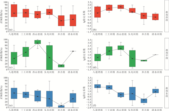
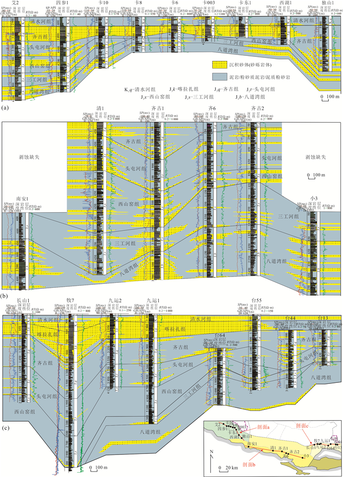
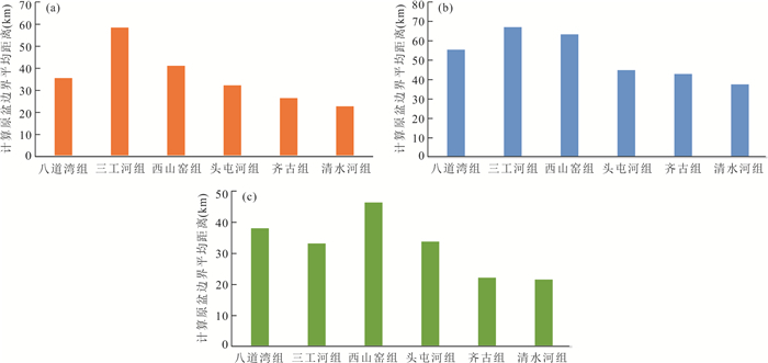
In order to clarify the characteristics and provenance-sedimentary system of the J-K prototype basin in southern Junggar, in this study it firstly analyzes the age data of mountains along the basin margin, and the temporal-spatial changes of Jurassic-Cretaceous sandstone clastic composition, conglomerate gravel composition, heavy minerals, paleo-currents, sedimentary sand body distribution. Then the original basin boundary distances are quantitively calculated. Together with the regional geological background, the boundary changes, and sedimentary provenance and depositional system evolution of the Jurassic-Cretaceous prototype basin in southern Junggar are restored. The research results show that the uplifting time of the mountains in the western section of the southern Junggar is overall earlier than the middle and eastern sections. And the parent rocks of the Jurassic-Cretaceous sedimentary provenance are mainly recirculating orogenic belt sedimentary rock. The distance between the boundary of prototype and nowadays basins is 22.2-67.0 km. The western section of southern Junggar is controlled by north and south provenance systems and influenced by the evolution of Chemo paleouplift. And the basin boundary has showed shrinking processes since Middle Jurassic. The middle section of southern Junggar is controlled by southern provenance system, and the basin boundary continuously expanded from the Early Jurassic to early period of the Middle Jurassic, and then began to shrink. In contrast, the basin boundary of eastern section continuously shrunk during the whole Jurassic. However, uplift processes of the Bogda Mountain since the Middle Jurassic have caused significant changes in the regional provenance-sedimentary system. Overall, current areas of the western and eastern sections are closer to the prototype basin boundary during the Late Jurassic, therefore, the proximal sedimentary systems are relatively well developed. However, the locations of the mid part of southern Junggar during the whole Jurassic are far from the original basin boundary, consequently, the contiguous sand bodies of proximal sedimentary are not well developed. In the Early Cretaceous, the boundaries of the southern Junggar basically shrunk to the vicinity of present basin boundary, but regional lacustrine flooding can lead to relatively regress of locations of the provenance area.
In order to clarify the characteristics and provenance-sedimentary system of the J-K prototype basin in southern Junggar, in this study it firstly analyzes the age data of mountains along the basin margin, and the temporal-spatial changes of Jurassic-Cretaceous sandstone clastic composition, conglomerate gravel composition, heavy minerals, paleo-currents, sedimentary sand body distribution. Then the original basin boundary distances are quantitively calculated. Together with the regional geological background, the boundary changes, and sedimentary provenance and depositional system evolution of the Jurassic-Cretaceous prototype basin in southern Junggar are restored. The research results show that the uplifting time of the mountains in the western section of the southern Junggar is overall earlier than the middle and eastern sections. And the parent rocks of the Jurassic-Cretaceous sedimentary provenance are mainly recirculating orogenic belt sedimentary rock. The distance between the boundary of prototype and nowadays basins is 22.2-67.0 km. The western section of southern Junggar is controlled by north and south provenance systems and influenced by the evolution of Chemo paleouplift. And the basin boundary has showed shrinking processes since Middle Jurassic. The middle section of southern Junggar is controlled by southern provenance system, and the basin boundary continuously expanded from the Early Jurassic to early period of the Middle Jurassic, and then began to shrink. In contrast, the basin boundary of eastern section continuously shrunk during the whole Jurassic. However, uplift processes of the Bogda Mountain since the Middle Jurassic have caused significant changes in the regional provenance-sedimentary system. Overall, current areas of the western and eastern sections are closer to the prototype basin boundary during the Late Jurassic, therefore, the proximal sedimentary systems are relatively well developed. However, the locations of the mid part of southern Junggar during the whole Jurassic are far from the original basin boundary, consequently, the contiguous sand bodies of proximal sedimentary are not well developed. In the Early Cretaceous, the boundaries of the southern Junggar basically shrunk to the vicinity of present basin boundary, but regional lacustrine flooding can lead to relatively regress of locations of the provenance area.


2024, 49(1): 123-139.
doi: 10.3799/dqkx.2022.193
Abstract:
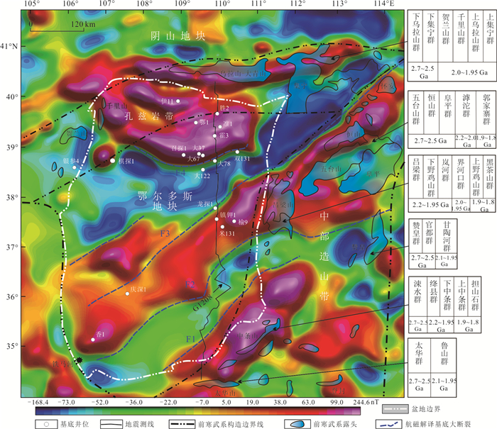
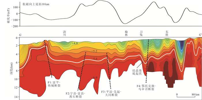
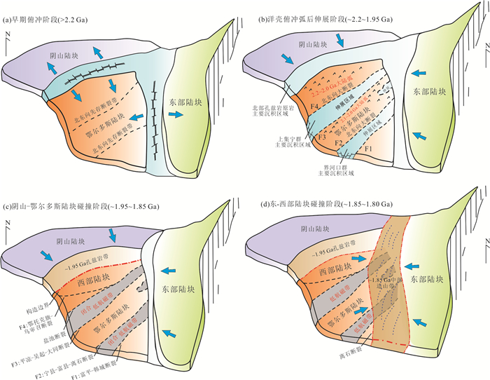
In order to understand the characteristics of basement structure in Ordos Basin, using 1∶200 000 magnetic data and seismic data, combined with the latest research progress of rock assemblage, rock magnetism, chronology and rock geochemistry of basement rock samples and Precambrian metamorphic rock series around the basin, the characteristics of basement primary faults and basement structure are studied in detail. On the basis of defining the age attributes of each basement area in the basin, the Paleoproterozoic tectonic evolution process of the basement is restored. The basement structure of the basin is controlled by four primary faults, which are divided into five secondary structural units. The lithology of each structural unit is the extension of the peripheral Archean-Paleoproterozoic to the basin. The high magnetic anomaly zones are mostly reflected by the Archean blocks, and the negative aeromagnetic anomaly zones are mostly reflected by the Paleoproterozoic sedimentary metamorphic rocks, showing the characteristics of NE horizontal blocking. The Paleoproterozoic tectonic evolution process includes the early stage of northern ocean crust subduction (> 2.2 Ga); subduction-back arc and NE extension-supracrustal rock deposition stage (~2.2-1.95 Ga); Yinshan Block and Ordos Block collision-NE closing of arc basin-forming western block stage (~1.95-1.85 Ga); eastern block collided with the eastern part of the western block-NE trending tectonic reformation-formation the Trans North China Orogen (~1.85-1.80 Ga).
In order to understand the characteristics of basement structure in Ordos Basin, using 1∶200 000 magnetic data and seismic data, combined with the latest research progress of rock assemblage, rock magnetism, chronology and rock geochemistry of basement rock samples and Precambrian metamorphic rock series around the basin, the characteristics of basement primary faults and basement structure are studied in detail. On the basis of defining the age attributes of each basement area in the basin, the Paleoproterozoic tectonic evolution process of the basement is restored. The basement structure of the basin is controlled by four primary faults, which are divided into five secondary structural units. The lithology of each structural unit is the extension of the peripheral Archean-Paleoproterozoic to the basin. The high magnetic anomaly zones are mostly reflected by the Archean blocks, and the negative aeromagnetic anomaly zones are mostly reflected by the Paleoproterozoic sedimentary metamorphic rocks, showing the characteristics of NE horizontal blocking. The Paleoproterozoic tectonic evolution process includes the early stage of northern ocean crust subduction (> 2.2 Ga); subduction-back arc and NE extension-supracrustal rock deposition stage (~2.2-1.95 Ga); Yinshan Block and Ordos Block collision-NE closing of arc basin-forming western block stage (~1.95-1.85 Ga); eastern block collided with the eastern part of the western block-NE trending tectonic reformation-formation the Trans North China Orogen (~1.85-1.80 Ga).


2024, 49(1): 140-154.
doi: 10.3799/dqkx.2022.120
Abstract:
In the northern part of Dongpu Depression, the salt rock is developed in Shahejie Formation, and the fluid characteristics are obviously affected by the salt rock. However, the study of fluid characteristics and evolution process in salt rocks is still very weak. In this paper, fluid inclusion samples collected in Es3 and Es4 sandstone reservoirs in Wenliu area were observed under microscope, and analyzed by homogenization temperature test and laser Raman test. The results show that there are three stages of hydrocarbon accumulation in the study area, and the main accumulation time is 0-8 Ma and 22-30 Ma. The formation water shows a partial desalting trend from 24 Ma to 30 Ma, and the salinity gradually increased from 24 Ma to this day. The formation water desalting period, oil and gas accumulation peak period and formation pressure relief period are highly coupled, and the fluid migration model is established accordingly. The evolution of formation water salinity reflects its migration process, and also indicates the direction of hydrocarbon migration and accumulation accompanying formation water migration. Desalting formation water contributes to the generation of secondary pores and improves reservoir properties, while supersaturated fluids may adversely affect the reservoir.
In the northern part of Dongpu Depression, the salt rock is developed in Shahejie Formation, and the fluid characteristics are obviously affected by the salt rock. However, the study of fluid characteristics and evolution process in salt rocks is still very weak. In this paper, fluid inclusion samples collected in Es3 and Es4 sandstone reservoirs in Wenliu area were observed under microscope, and analyzed by homogenization temperature test and laser Raman test. The results show that there are three stages of hydrocarbon accumulation in the study area, and the main accumulation time is 0-8 Ma and 22-30 Ma. The formation water shows a partial desalting trend from 24 Ma to 30 Ma, and the salinity gradually increased from 24 Ma to this day. The formation water desalting period, oil and gas accumulation peak period and formation pressure relief period are highly coupled, and the fluid migration model is established accordingly. The evolution of formation water salinity reflects its migration process, and also indicates the direction of hydrocarbon migration and accumulation accompanying formation water migration. Desalting formation water contributes to the generation of secondary pores and improves reservoir properties, while supersaturated fluids may adversely affect the reservoir.


2024, 49(1): 155-173.
doi: 10.3799/dqkx.2022.123
Abstract:
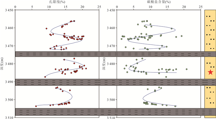
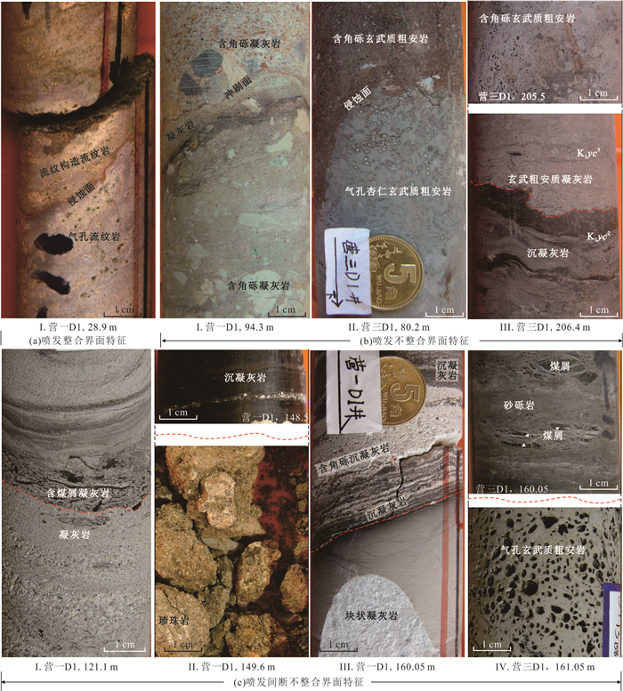
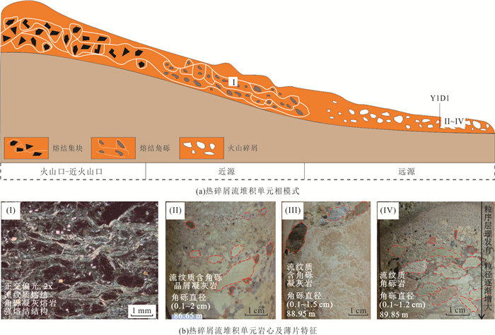
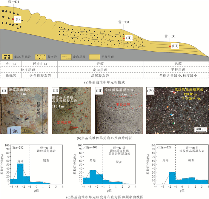
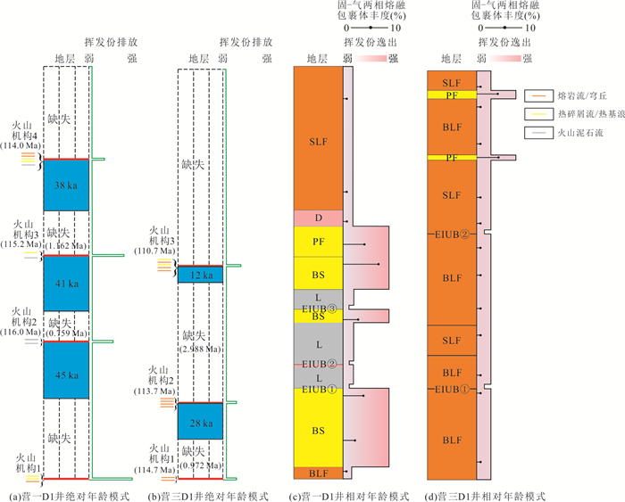
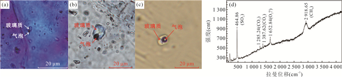
Volcano stratigraphy has special temporal and spatial attributes and geological record characteristics, but it has not attracted enough attention in the analysis of basin filling. In order to further clarify the geological attributes of volcano stratigraphy, the characteristics and geologic significance of volcano stratigraphic elements of Lower Cretaceous Yingcheng Formation in Songliao Basin are studied by taking the full coring shallow drilling wells (Y1D1 and Y3D1) as examples. 3 eruptive interval unconformity boundaries and 10 eruptive conformity/unconformity boundaries are identified in the volcano stratigraphy of the first member of Yingcheng Formation in Well Y1D1. 2 eruptive interval unconformity boundaries and 8 eruptive conformity/unconformity boundaries are identified in the volcano stratigraphy of the third member of Yingcheng Formation in Well Y3D1.According to the attributes of eruptive interval unconformity boundary, the volcano stratigraphy of Well Y1D1 can be divided into 4 volcano edifices, and the volcano stratigraphy of Well Y3D1 can be divided into 3 volcano edifices.Rare earth and trace elements have a good response to the volcano edifice. There are 6 types of deposit unit: simple lava flow, braided lava flow, dome, pyroclastic flow, base surge and lahar. The emission intensity of volcano gas during the eruption of lava units is weaker than that of pyroclastic units.Volcano stratigraphy has the time attributes of short construction time and long eruptive interruption time, and the construction rate of volcano stratigraphy cannot be calculated simply by using the stratigraphy thickness and the time difference between the top and bottom of the test.
Volcano stratigraphy has special temporal and spatial attributes and geological record characteristics, but it has not attracted enough attention in the analysis of basin filling. In order to further clarify the geological attributes of volcano stratigraphy, the characteristics and geologic significance of volcano stratigraphic elements of Lower Cretaceous Yingcheng Formation in Songliao Basin are studied by taking the full coring shallow drilling wells (Y1D1 and Y3D1) as examples. 3 eruptive interval unconformity boundaries and 10 eruptive conformity/unconformity boundaries are identified in the volcano stratigraphy of the first member of Yingcheng Formation in Well Y1D1. 2 eruptive interval unconformity boundaries and 8 eruptive conformity/unconformity boundaries are identified in the volcano stratigraphy of the third member of Yingcheng Formation in Well Y3D1.According to the attributes of eruptive interval unconformity boundary, the volcano stratigraphy of Well Y1D1 can be divided into 4 volcano edifices, and the volcano stratigraphy of Well Y3D1 can be divided into 3 volcano edifices.Rare earth and trace elements have a good response to the volcano edifice. There are 6 types of deposit unit: simple lava flow, braided lava flow, dome, pyroclastic flow, base surge and lahar. The emission intensity of volcano gas during the eruption of lava units is weaker than that of pyroclastic units.Volcano stratigraphy has the time attributes of short construction time and long eruptive interruption time, and the construction rate of volcano stratigraphy cannot be calculated simply by using the stratigraphy thickness and the time difference between the top and bottom of the test.


2024, 49(1): 174-188.
doi: 10.3799/dqkx.2022.199
Abstract:
In order to improve the three-dimensional modeling accuracy of the few well areas in the tidal-controlled estuary bay reservoir, the sedimentary dynamics simulation and multipoint geostatistics modeling method were used on the M1 layer of the J oilfield in the Oriente Basin, South America, to establish the sedimentation model of the study area with the selected terrain slope break height, tidal amplitude, estuary velocity, sediment particle size and other parameters. Considering the reservoir characteristics of the M1 layer, the sedimentation simulation results are converted into a three-dimensional training template. Combined with the three-dimensional training template and logging data, the multipoint geostatistics method was used to construct a fine three-dimensional geological model of the tidal-controlled estuary reservoir under the constraints of sedimentary dynamics simulation. The results show that under the constraints of the three-dimensional training template established by the sedimentary dynamics, the results of the core wells in the model fit well with the cores, and the relative error between the verification wells and the logging data is 7.6%, which are much better than those obtained by the sequential Gaussian simulation. It indicates that, in the tidal-controlled estuary bay reservoir, the establishment of a three-dimensional training template constrained reservoir model through sedimentary dynamics could effectively improve the accuracy of model in areas with a few wells, which are supported by the cross-validation results of verification wells. It will provide guidance for the exploration and development of oil-bearing reservoirs in tidal-controlled estuaries.
In order to improve the three-dimensional modeling accuracy of the few well areas in the tidal-controlled estuary bay reservoir, the sedimentary dynamics simulation and multipoint geostatistics modeling method were used on the M1 layer of the J oilfield in the Oriente Basin, South America, to establish the sedimentation model of the study area with the selected terrain slope break height, tidal amplitude, estuary velocity, sediment particle size and other parameters. Considering the reservoir characteristics of the M1 layer, the sedimentation simulation results are converted into a three-dimensional training template. Combined with the three-dimensional training template and logging data, the multipoint geostatistics method was used to construct a fine three-dimensional geological model of the tidal-controlled estuary reservoir under the constraints of sedimentary dynamics simulation. The results show that under the constraints of the three-dimensional training template established by the sedimentary dynamics, the results of the core wells in the model fit well with the cores, and the relative error between the verification wells and the logging data is 7.6%, which are much better than those obtained by the sequential Gaussian simulation. It indicates that, in the tidal-controlled estuary bay reservoir, the establishment of a three-dimensional training template constrained reservoir model through sedimentary dynamics could effectively improve the accuracy of model in areas with a few wells, which are supported by the cross-validation results of verification wells. It will provide guidance for the exploration and development of oil-bearing reservoirs in tidal-controlled estuaries.


2024, 49(1): 189-208.
doi: 10.3799/dqkx.2022.194
Abstract:
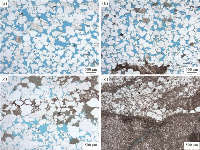
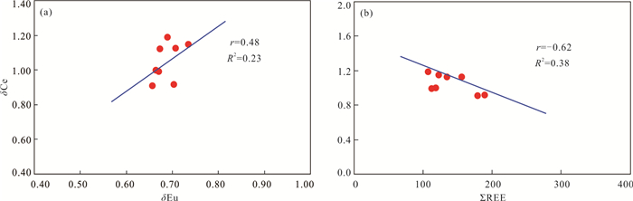
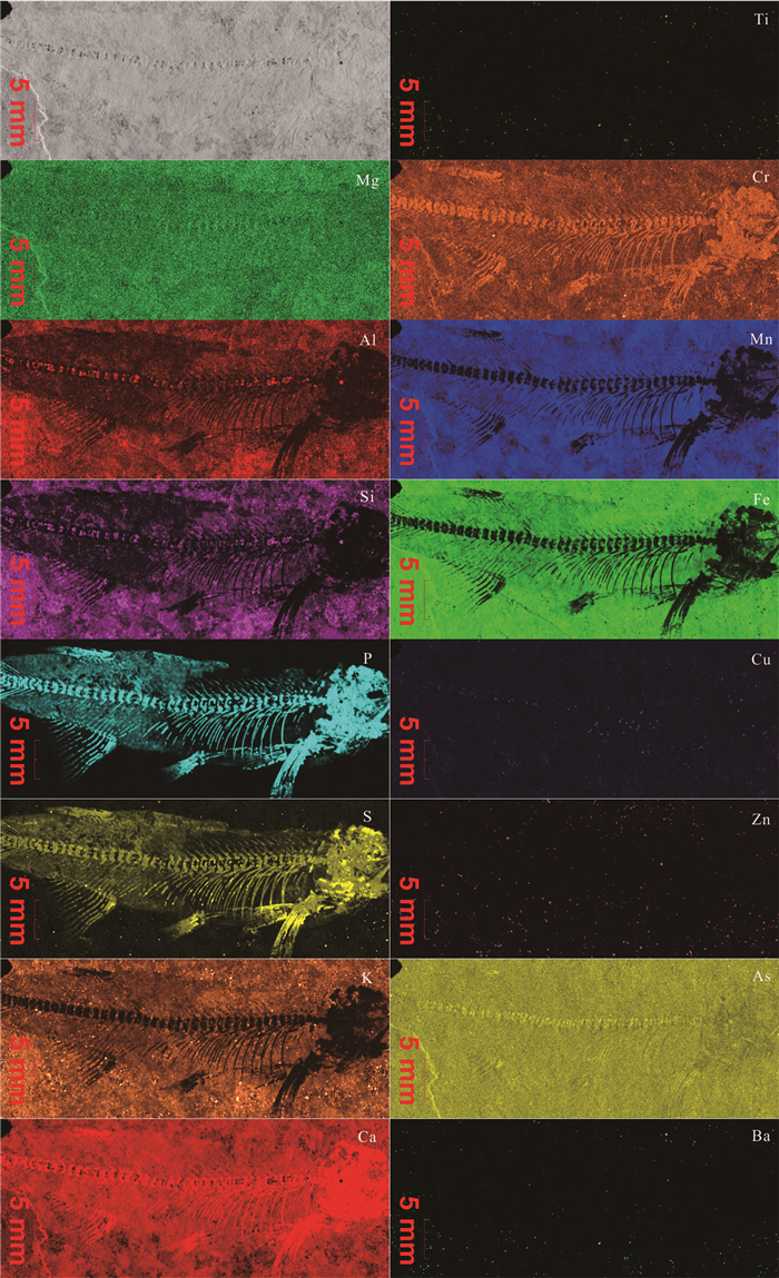
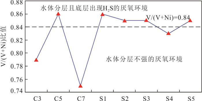
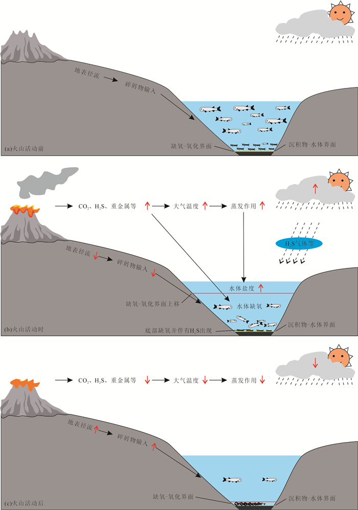
In order to find out the taphonomy and paleoclimate and paleoenvironment significance of Lycoptera-bearing Liwaxia Formation in the Liupanshan area, multiple methods of analyses are used. XRD analysis shows that the fossil-bearing is mainly composed of ankerite (42.70%) and quartz (41.50%), while its overlying and underlying neighbors are mainly composed of quartz (average 40.40%) and feldspar (total average 15.98%). The major elements of the fossil-bearing unit are CaO (average 20.61%) and MgO (average 10.52%), while its neighboring units are enriched in SiO2 (average 54.58%) and Al2O3 (average 14.79%). The paleoclimate indexes MgO/CaO and Sr/Cu indicate a dry hot climate, the paleo-salinity index m value and Sr/Ba indicate a high salinity environment, and the paleo-redox environment indexes Th/U and V/(V+Ni) indicate a stratified aquatic environment with euxinic bottom water. The mass mortality of fishes was caused by a rapid redox change of the water body and toxicity of H2S. It is likely that the anoxia was a response to OAE1a in the Liupanshan area, and the dry hot climate and high salinity water were caused by the elevated atmospheric CO2 concentration in the Middle Cretaceous. Additionally, the euxinic bottom water provides favorable conditions for the preservation of fish fossils.
In order to find out the taphonomy and paleoclimate and paleoenvironment significance of Lycoptera-bearing Liwaxia Formation in the Liupanshan area, multiple methods of analyses are used. XRD analysis shows that the fossil-bearing is mainly composed of ankerite (42.70%) and quartz (41.50%), while its overlying and underlying neighbors are mainly composed of quartz (average 40.40%) and feldspar (total average 15.98%). The major elements of the fossil-bearing unit are CaO (average 20.61%) and MgO (average 10.52%), while its neighboring units are enriched in SiO2 (average 54.58%) and Al2O3 (average 14.79%). The paleoclimate indexes MgO/CaO and Sr/Cu indicate a dry hot climate, the paleo-salinity index m value and Sr/Ba indicate a high salinity environment, and the paleo-redox environment indexes Th/U and V/(V+Ni) indicate a stratified aquatic environment with euxinic bottom water. The mass mortality of fishes was caused by a rapid redox change of the water body and toxicity of H2S. It is likely that the anoxia was a response to OAE1a in the Liupanshan area, and the dry hot climate and high salinity water were caused by the elevated atmospheric CO2 concentration in the Middle Cretaceous. Additionally, the euxinic bottom water provides favorable conditions for the preservation of fish fossils.


2024, 49(1): 209-223.
doi: 10.3799/dqkx.2022.075
Abstract:
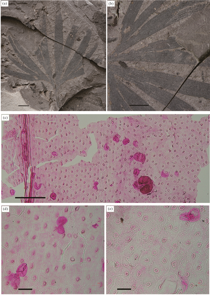
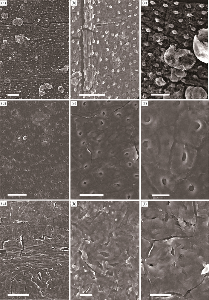
Epidermal features of fossil ginkgophyta are one of the good materials for estimating the paleoatmospheric CO2 concentration. In this study, a fossil Ginkgoites species, Ginkgoites sibirica is firstly described based on leaf morphology and epidermal features from the Lower Cretaceous Chijinbao Formation in the Zhongkouzi Basin, Beishan area, Northwest China. The paleo-CO2 was 766-1 277 ppmv during the Hauterivian to Barremian based on the stomatal ratio method, which is consistent with the results of other studies. The CO2 variation trend during the Early Jurassic to the Early Cretaceous is reconstructed based on the leaf gas-exchange model in combination with previous data. The paleo-CO2 was 643-1 136 ppmv during the Jurassic and 548 ppmv during the Hauterivian to Barremian. The results show that the CO2 concentration was high in the Early and Middle Jurassic, with a decreasing trend toward the Cretaceous, and then showed a significant increase during Early and Middle Cretaceous. The paleo-CO2 reached its peak during the late Early Cretaceous, and then decreased significantly afterwards. Studies have shown that the leaf gas-exchange model can be an effective proxy for reconstructing paleoclimate.
Epidermal features of fossil ginkgophyta are one of the good materials for estimating the paleoatmospheric CO2 concentration. In this study, a fossil Ginkgoites species, Ginkgoites sibirica is firstly described based on leaf morphology and epidermal features from the Lower Cretaceous Chijinbao Formation in the Zhongkouzi Basin, Beishan area, Northwest China. The paleo-CO2 was 766-1 277 ppmv during the Hauterivian to Barremian based on the stomatal ratio method, which is consistent with the results of other studies. The CO2 variation trend during the Early Jurassic to the Early Cretaceous is reconstructed based on the leaf gas-exchange model in combination with previous data. The paleo-CO2 was 643-1 136 ppmv during the Jurassic and 548 ppmv during the Hauterivian to Barremian. The results show that the CO2 concentration was high in the Early and Middle Jurassic, with a decreasing trend toward the Cretaceous, and then showed a significant increase during Early and Middle Cretaceous. The paleo-CO2 reached its peak during the late Early Cretaceous, and then decreased significantly afterwards. Studies have shown that the leaf gas-exchange model can be an effective proxy for reconstructing paleoclimate.


2024, 49(1): 224-237.
doi: 10.3799/dqkx.2022.161
Abstract:
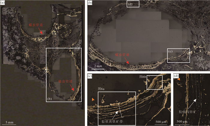
Hydrothermal tubeworms biomineralization is widely developed in seafloor hydrothermal field, but the processes of mineralization, weathering and oxidation, as well as the controlling factors are poorly understood. In this paper, we use a detailed mineralogy observation and elemental in situ analysis methods to study mineralized worm-tubes from hydrothermal fields on the East Pacific Rise. The results show that the samples have a multilayered mineralization structure dominated by colloform pyrite and are classified into two types of fast (F-type) and slow mineralization (S-type). Compared with the "S-type", the "F-type" has thicker tube walls, fewer concentric layers, smaller gaps, and uniform thickness. This is mainly influenced by the rate of mineral precipitation, i.e., the rapid precipitation of minerals accelerates worm tube growth and mineralization. In addition, the distribution of framboidal pyrite on the outer layers of "F-type" worm-tube wall suggests that the directional growth of nano-micron crystalline sulfide minerals is an important intermediate pathway for the formation of the colloform pyrite bands. The "S-type " is characterized by a gradual increase in oxidation and a gradual thinning of colloform pyrite bands from the inside to the outside, indicating that the sample was both affected by the oxidation of late low-temperature, Fe-Si-rich hydrothermal fluids and low-temperature seawater weathering. This study provides a new insight into understanding the mineralization mechanism of worm-tubes from modern seafloor hydrothermal systems.
Hydrothermal tubeworms biomineralization is widely developed in seafloor hydrothermal field, but the processes of mineralization, weathering and oxidation, as well as the controlling factors are poorly understood. In this paper, we use a detailed mineralogy observation and elemental in situ analysis methods to study mineralized worm-tubes from hydrothermal fields on the East Pacific Rise. The results show that the samples have a multilayered mineralization structure dominated by colloform pyrite and are classified into two types of fast (F-type) and slow mineralization (S-type). Compared with the "S-type", the "F-type" has thicker tube walls, fewer concentric layers, smaller gaps, and uniform thickness. This is mainly influenced by the rate of mineral precipitation, i.e., the rapid precipitation of minerals accelerates worm tube growth and mineralization. In addition, the distribution of framboidal pyrite on the outer layers of "F-type" worm-tube wall suggests that the directional growth of nano-micron crystalline sulfide minerals is an important intermediate pathway for the formation of the colloform pyrite bands. The "S-type " is characterized by a gradual increase in oxidation and a gradual thinning of colloform pyrite bands from the inside to the outside, indicating that the sample was both affected by the oxidation of late low-temperature, Fe-Si-rich hydrothermal fluids and low-temperature seawater weathering. This study provides a new insight into understanding the mineralization mechanism of worm-tubes from modern seafloor hydrothermal systems.


2024, 49(1): 238-252.
doi: 10.3799/dqkx.2022.143
Abstract:
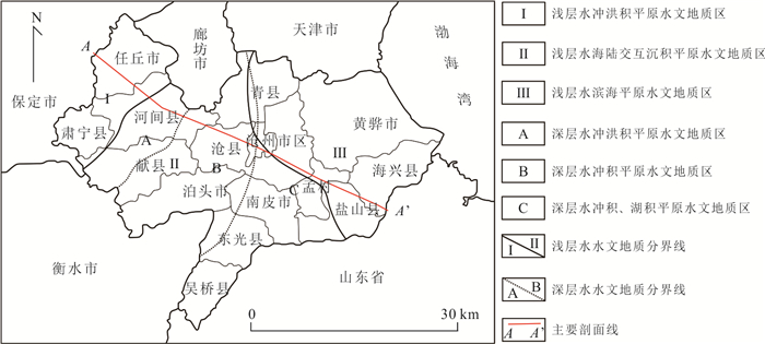
In order to study the impact of land subsidence on minable groundwater resources, taking Cangzhou City in North China as an example, based on Biot consolidation theory, a three-dimensional variable-parameter fully coupled viscoelastic-plastic numerical model of groundwater exploitation and land subsidence is established. Regarding groundwater mining from 2019 to 2030 based on current conditions and a ban on mining from 2031 to 2040 (scheme 1), compression mining from 2019 to 2030 and a ban on mining from 2031 to 2040 (scheme 2), and continuous ban on groundwater mining from 2019 to 2040 (scheme 3), the land subsidence of each scheme is predicted, and the minable groundwater resources of each scheme from 2041 to 2050 are reasonably evaluated. Results show: from 2041 to 2050, the minable groundwater resources of scheme 1, scheme 2 and scheme 3 are 1.29×10⁸ m3/a, 1.35×10⁸ m3/a and 1.43×10⁸ m3/a, respectively. Compared with scheme 1, the maximum cumulative land subsidence of scheme 2 is reduced by 84.4 mm, and its minable groundwater resources increase by 6×10⁶ m3/a. Compared with scheme 1, scheme 3 achieves a ground rebound of 88 mm, and its minable groundwater resources increase by 1.4×10⁷ m3/a. These fully explain that the amount of recoverable groundwater resources is relatively small under the condition of severe land subsidence.
In order to study the impact of land subsidence on minable groundwater resources, taking Cangzhou City in North China as an example, based on Biot consolidation theory, a three-dimensional variable-parameter fully coupled viscoelastic-plastic numerical model of groundwater exploitation and land subsidence is established. Regarding groundwater mining from 2019 to 2030 based on current conditions and a ban on mining from 2031 to 2040 (scheme 1), compression mining from 2019 to 2030 and a ban on mining from 2031 to 2040 (scheme 2), and continuous ban on groundwater mining from 2019 to 2040 (scheme 3), the land subsidence of each scheme is predicted, and the minable groundwater resources of each scheme from 2041 to 2050 are reasonably evaluated. Results show: from 2041 to 2050, the minable groundwater resources of scheme 1, scheme 2 and scheme 3 are 1.29×10⁸ m3/a, 1.35×10⁸ m3/a and 1.43×10⁸ m3/a, respectively. Compared with scheme 1, the maximum cumulative land subsidence of scheme 2 is reduced by 84.4 mm, and its minable groundwater resources increase by 6×10⁶ m3/a. Compared with scheme 1, scheme 3 achieves a ground rebound of 88 mm, and its minable groundwater resources increase by 1.4×10⁷ m3/a. These fully explain that the amount of recoverable groundwater resources is relatively small under the condition of severe land subsidence.


2024, 49(1): 253-270.
doi: 10.3799/dqkx.2022.349
Abstract:
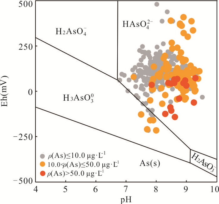
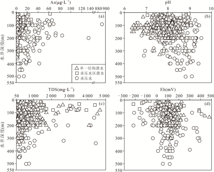
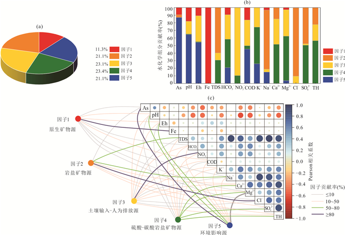
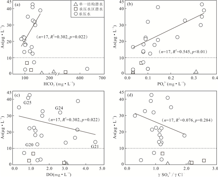
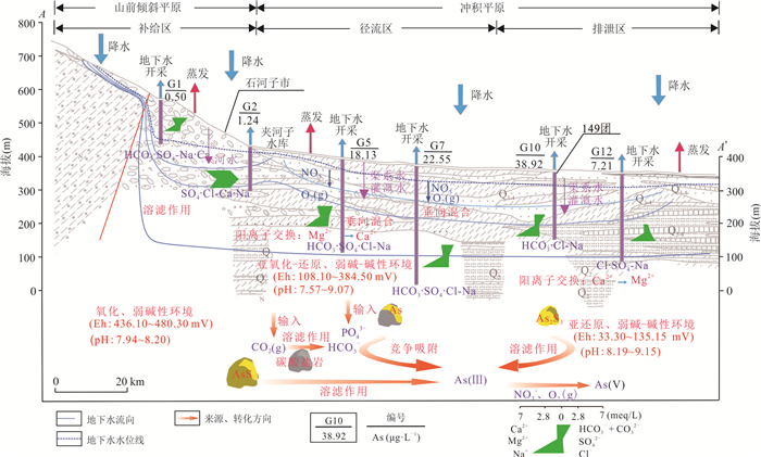
Junggar Basin is a typical inland basin with high arsenic groundwater distribution. Groundwater is an important drinking water source in the basin. Regional water supply safety is at risk. Migration and transformation of high arsenic groundwater need to be further investigated. In this study, the oasis belt in the middle part of the northern piedmont of Tianshan Mountain was taken as the research area. Semivariogram model and UNMIX source analysis model were used to analyze the distribution of arsenic in groundwater and the source contribution rate of groundwater chemical indexes, and influencing factors of arsenic migration. Transformation and enrichment in high arsenic groundwater in the typical profile were analyzed in combination with geological conditions, occurrence environment and hydrogeochemical action. Results show that groundwater in the study area is generally freshwater with weak alkaline and slightly reduced environment. Groundwater As concentration ranges between ND and 887.0 μg·L-1, with an average of 11.2 μg·L-1. Hydrochemical types of high arsenic groundwater (ρ (As) > 10 μg·L-1) are mainly HCO3·SO4·Cl⁃Na (HSL⁃N) and HCO3·SO4⁃Na (Na·Ca) (HS⁃N (NC)) types. Proportions of high arsenic groundwater in single-structure phreatic water, phreatic water in confined water area, and confined water are 0.4%, 6.4%, and 18.6%, respectively. Contribution rates of native mineral source, rock salt mineral source, soil input-human emission source, sulfuric-carbonate mineral source and environmental source to groundwater hydrochemical indexes are 11.3%, 21.1%, 23.1%, 23.4% and 21.1%, respectively. Arsenic species in 24 groups of a total of 25 groundwater samples of typical profiles is only As (Ⅴ) (96.0% of the sampling sites). From piedmont plain to alluvial plain, along groundwater flow, the variation trend of groundwater total arsenic concentration firstly increased and then decreased. Arsenic enrichment in occurrence environment is affected by groundwater hydrochemical indexes including pH, Eh, HCO3- and PO43-, which is also related to geological, hydrogeological conditions, organic matter degradation, and dissolution.
Junggar Basin is a typical inland basin with high arsenic groundwater distribution. Groundwater is an important drinking water source in the basin. Regional water supply safety is at risk. Migration and transformation of high arsenic groundwater need to be further investigated. In this study, the oasis belt in the middle part of the northern piedmont of Tianshan Mountain was taken as the research area. Semivariogram model and UNMIX source analysis model were used to analyze the distribution of arsenic in groundwater and the source contribution rate of groundwater chemical indexes, and influencing factors of arsenic migration. Transformation and enrichment in high arsenic groundwater in the typical profile were analyzed in combination with geological conditions, occurrence environment and hydrogeochemical action. Results show that groundwater in the study area is generally freshwater with weak alkaline and slightly reduced environment. Groundwater As concentration ranges between ND and 887.0 μg·L-1, with an average of 11.2 μg·L-1. Hydrochemical types of high arsenic groundwater (ρ (As) > 10 μg·L-1) are mainly HCO3·SO4·Cl⁃Na (HSL⁃N) and HCO3·SO4⁃Na (Na·Ca) (HS⁃N (NC)) types. Proportions of high arsenic groundwater in single-structure phreatic water, phreatic water in confined water area, and confined water are 0.4%, 6.4%, and 18.6%, respectively. Contribution rates of native mineral source, rock salt mineral source, soil input-human emission source, sulfuric-carbonate mineral source and environmental source to groundwater hydrochemical indexes are 11.3%, 21.1%, 23.1%, 23.4% and 21.1%, respectively. Arsenic species in 24 groups of a total of 25 groundwater samples of typical profiles is only As (Ⅴ) (96.0% of the sampling sites). From piedmont plain to alluvial plain, along groundwater flow, the variation trend of groundwater total arsenic concentration firstly increased and then decreased. Arsenic enrichment in occurrence environment is affected by groundwater hydrochemical indexes including pH, Eh, HCO3- and PO43-, which is also related to geological, hydrogeological conditions, organic matter degradation, and dissolution.


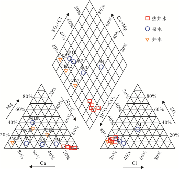
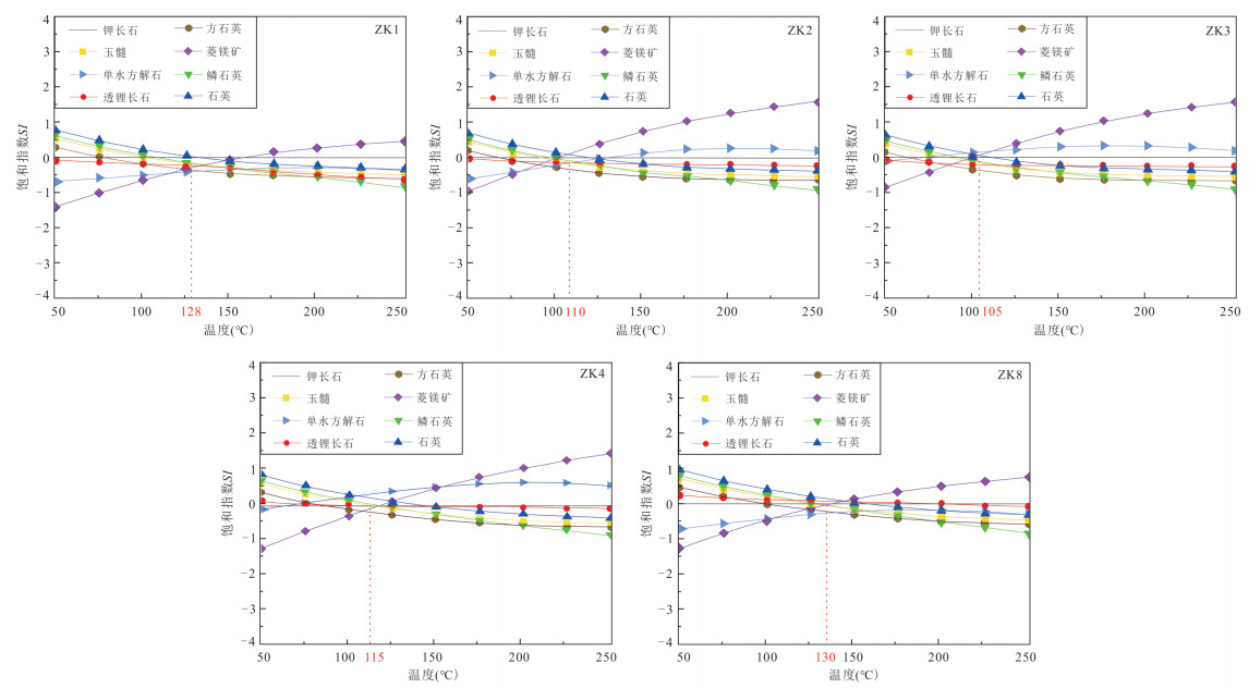
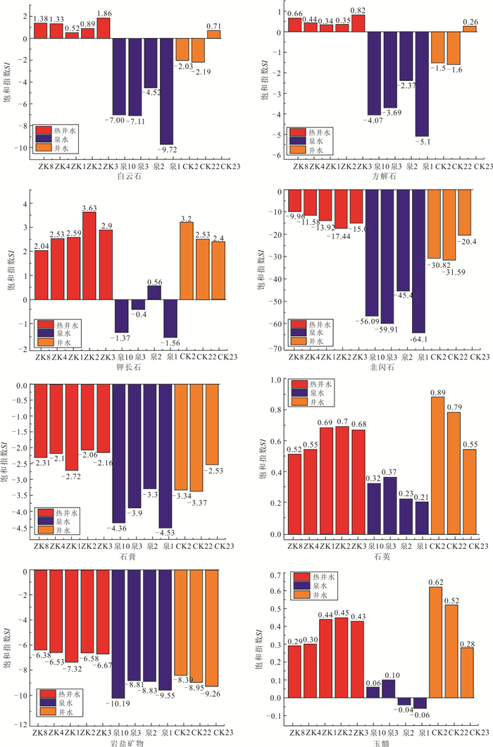
2024, 49(1): 271-287.
doi: 10.3799/dqkx.2022.170
Abstract:
The Na+ content in the geothermal water in the high-temperature geothermal system generally exceeds 300 mg/L, and the salinity is also large (TDS > 1 000 mg/L). In the medium- and low-temperature geothermal system, the Na+ content of low-salinity geothermal water is generally less than 160 mg/L. However, geothermal water with Na+ as high as 325.4 mg/L and TDS less than 650 mg/L was found in the Huangshadong medium-low temperature geothermal system in Guangdong. It is difficult to explain their formation with typical hydrogeochemical reactions (mineral dissolution, ion exchange, etc.). The water chemistry results show that the chemical types of geothermal water are all HCO3-Na type, with high sodium content (average 240.06 mg/L). The results of hydrogen and oxygen isotopes show that both geothermal water and shallow groundwater have the same atmospheric source which is in the Yaokeng mountainous area. According to the hydrochemical geothermometer and the multicomponent mineral equilibrium (MME), the thermal storage temperature is estimated to be 100-130 ℃ and the maximum circulation depth is 2.43 km. Cl- is used as a mixing ratio calculation indicator to reveal that the proportion of shallow groundwater mixed into geothermal water is 51%-72%, The actual content of Na+ in deep geothermal water should be as high as 685.2 mg/L. The simulation results of water-rock interaction indicate that mineral dissolution and ion exchange make a minor contribution to Na+ enrichment in geothermal water, and also reveal the existence of additional sources of Na+ in geothermal water. Granite fluid inclusions are tiny but widespread among crystalline mineral grains, and its average Na+ content is 11 758.9 mg/L. In the case of geothermal heating, the fluid inclusions at and near the fracture and granite fissure network expand and rupture, and the fluid is mixed into the geothermal water, providing average of 83% of Na+ for the geothermal water. Therefore, granite fluid inclusions may be the main source of Na+ for the low-salinity and high-sodium geothermal water in medium-low temperature geothermal system.
The Na+ content in the geothermal water in the high-temperature geothermal system generally exceeds 300 mg/L, and the salinity is also large (TDS > 1 000 mg/L). In the medium- and low-temperature geothermal system, the Na+ content of low-salinity geothermal water is generally less than 160 mg/L. However, geothermal water with Na+ as high as 325.4 mg/L and TDS less than 650 mg/L was found in the Huangshadong medium-low temperature geothermal system in Guangdong. It is difficult to explain their formation with typical hydrogeochemical reactions (mineral dissolution, ion exchange, etc.). The water chemistry results show that the chemical types of geothermal water are all HCO3-Na type, with high sodium content (average 240.06 mg/L). The results of hydrogen and oxygen isotopes show that both geothermal water and shallow groundwater have the same atmospheric source which is in the Yaokeng mountainous area. According to the hydrochemical geothermometer and the multicomponent mineral equilibrium (MME), the thermal storage temperature is estimated to be 100-130 ℃ and the maximum circulation depth is 2.43 km. Cl- is used as a mixing ratio calculation indicator to reveal that the proportion of shallow groundwater mixed into geothermal water is 51%-72%, The actual content of Na+ in deep geothermal water should be as high as 685.2 mg/L. The simulation results of water-rock interaction indicate that mineral dissolution and ion exchange make a minor contribution to Na+ enrichment in geothermal water, and also reveal the existence of additional sources of Na+ in geothermal water. Granite fluid inclusions are tiny but widespread among crystalline mineral grains, and its average Na+ content is 11 758.9 mg/L. In the case of geothermal heating, the fluid inclusions at and near the fracture and granite fissure network expand and rupture, and the fluid is mixed into the geothermal water, providing average of 83% of Na+ for the geothermal water. Therefore, granite fluid inclusions may be the main source of Na+ for the low-salinity and high-sodium geothermal water in medium-low temperature geothermal system.


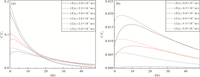
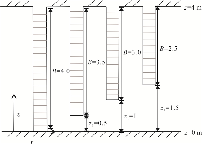
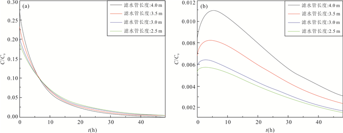
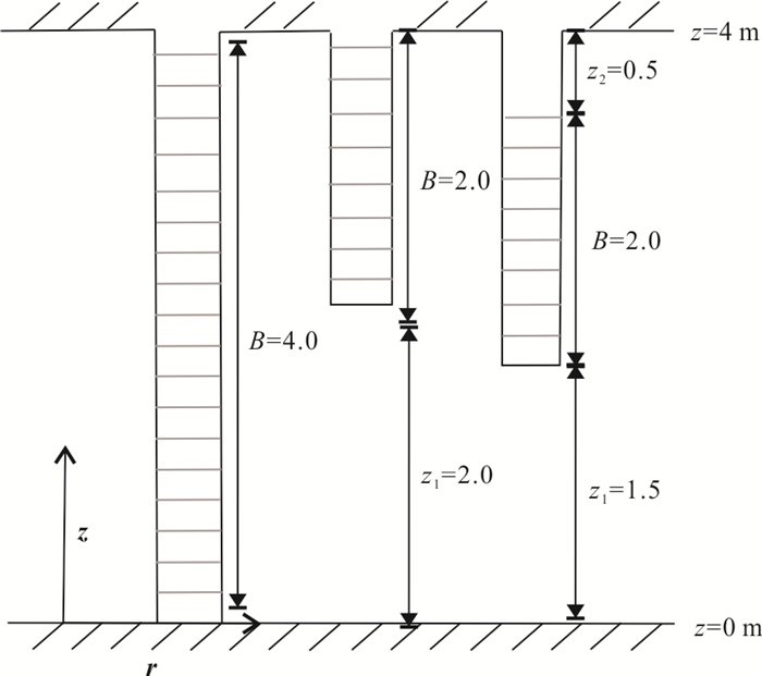
2024, 49(1): 288-298.
doi: 10.3799/dqkx.2022.148
Abstract:
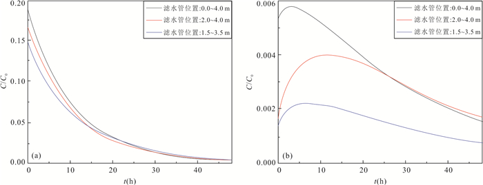
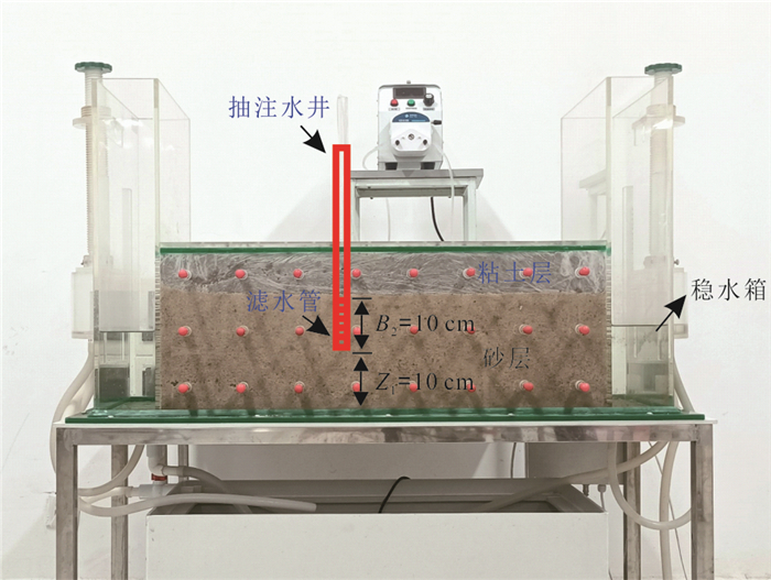
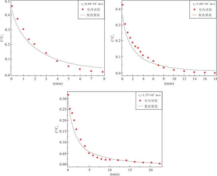
For the purpose of analyzing the influencing mechanism of partially penetrating well on single-well push-pull (SWPP) tests, this study employed COMSOL Multiphysics to develop a numerical model of SWPP test, in which the impacts of the length and location of screen on breakthrough curves (BTCs) were investigated. Meanwhile, a laboratory experiment of SWPP test with partially penetrating well was conducted, verifying the reliability of the proposed model by fitting the observed and simulated BTCs. The results show that a shorter screen length leads to a lower concentration of BTC in the early stage; meanwhile a shorter unscreened segment near the top of aquifer results in a lower concentration in the early stage. Additionally, the error analysis of parameter inversion indicates that the numerical model is quantified for the estimations of groundwater flow velocity, porosity and dispersion by fitting BTCs. Overall, the complicated flow field in the vicinity of partially penetrating wells leads to a non-uniform spatial distribution of solute, which has a significant effect on the BTCs and increases the parameter inversion error if using the traditional fully penetrating well model. Nevertheless, the SWPP test model developed in this paper has high fitting accuracy and can be applied to SWPP test under partially penetrating conditions.
For the purpose of analyzing the influencing mechanism of partially penetrating well on single-well push-pull (SWPP) tests, this study employed COMSOL Multiphysics to develop a numerical model of SWPP test, in which the impacts of the length and location of screen on breakthrough curves (BTCs) were investigated. Meanwhile, a laboratory experiment of SWPP test with partially penetrating well was conducted, verifying the reliability of the proposed model by fitting the observed and simulated BTCs. The results show that a shorter screen length leads to a lower concentration of BTC in the early stage; meanwhile a shorter unscreened segment near the top of aquifer results in a lower concentration in the early stage. Additionally, the error analysis of parameter inversion indicates that the numerical model is quantified for the estimations of groundwater flow velocity, porosity and dispersion by fitting BTCs. Overall, the complicated flow field in the vicinity of partially penetrating wells leads to a non-uniform spatial distribution of solute, which has a significant effect on the BTCs and increases the parameter inversion error if using the traditional fully penetrating well model. Nevertheless, the SWPP test model developed in this paper has high fitting accuracy and can be applied to SWPP test under partially penetrating conditions.


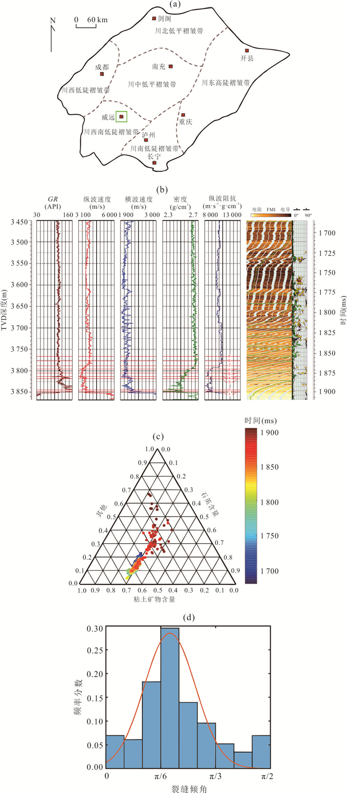
Orthorhombic Anisotropic Rock Physics Modeling for Fractured Marine Shale Reservoir in Sichuan Basin
2024, 49(1): 299-312.
doi: 10.3799/dqkx.2022.229
Abstract:
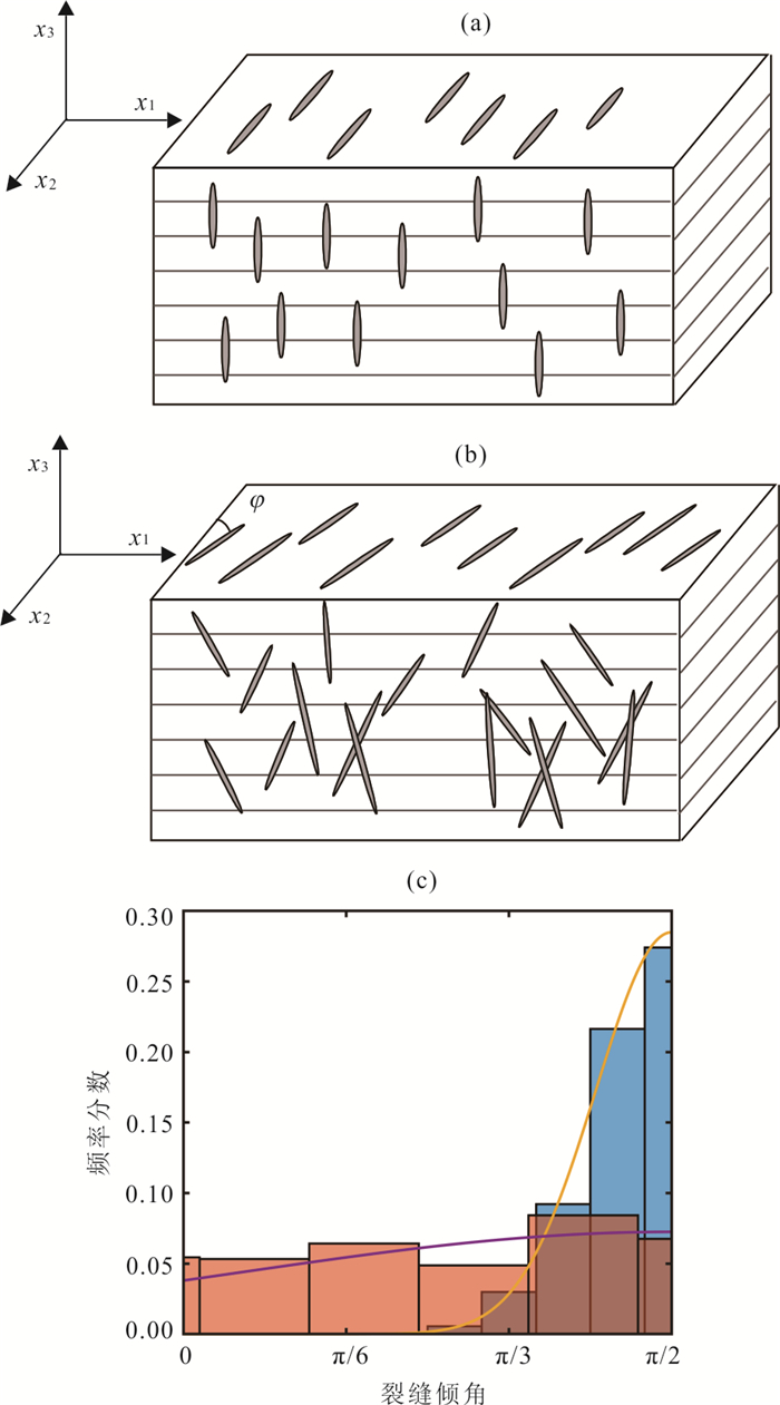
Fractured shale often represents complex anisotropy characteristics. A proper rock physics model can be helpful for accurate prediction of fracture properties. In this paper it proposes an orthorhombic anisotropic rock physics model, considering the distribution characteristics of fracture dip and accurate characterization of VTI (Vertically Transverse Isotropy) characteristics, for the fractured shale reservoir of Wufeng-Longmaxi Formation in Weiyuan-Rongxian area, Sichuan Basin. The modeling results of the well analysis show that the average fracture dip, the standard deviation of fracture dip, and the variation range of fracture dip in shale have significant influence on azimuthal anisotropy. The anisotropy parameters related to S-wave velocity\begin{document}$ {\gamma }^{\left(2\right)} $\end{document} \begin{document}$ {\gamma }^{\left(3\right)} $\end{document} \begin{document}$ {\varepsilon }^{\left(2\right)} $\end{document} \begin{document}$ {\delta }^{\left(2\right)} $\end{document} \begin{document}$ {\delta }^{\left(3\right)} $\end{document} \begin{document}$ {\varepsilon }^{\left(3\right)} $\end{document}
Fractured shale often represents complex anisotropy characteristics. A proper rock physics model can be helpful for accurate prediction of fracture properties. In this paper it proposes an orthorhombic anisotropic rock physics model, considering the distribution characteristics of fracture dip and accurate characterization of VTI (Vertically Transverse Isotropy) characteristics, for the fractured shale reservoir of Wufeng-Longmaxi Formation in Weiyuan-Rongxian area, Sichuan Basin. The modeling results of the well analysis show that the average fracture dip, the standard deviation of fracture dip, and the variation range of fracture dip in shale have significant influence on azimuthal anisotropy. The anisotropy parameters related to S-wave velocity


2024, 49(1): 313-323.
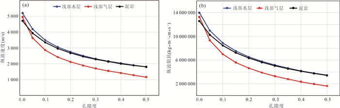
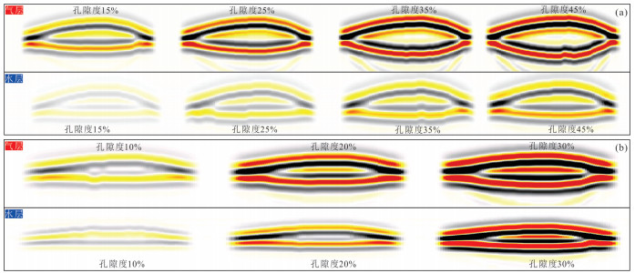
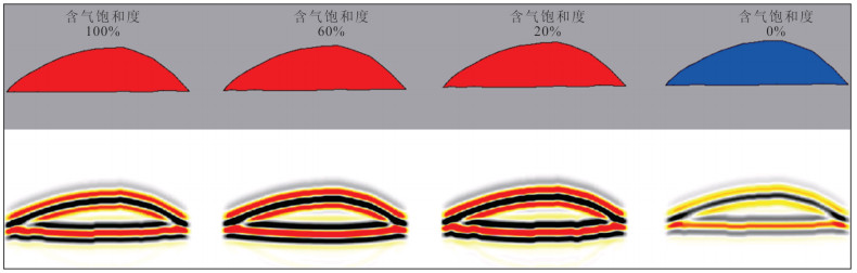
doi: 10.3799/dqkx.2022.339
Abstract:
Shallow gas occurs in unconsolidated rocks with low diagenetic strength in the shallow part, and its petrophysical characteristics and seismic reflection characteristics are different from those of deep diagenetic rocks. Using shallow logging data, it analyzes the effects of shallow lithology and fluid properties on rock velocity, density and P-S wave velocity ratio in the basin, and defines the sensitive elastic parameters of shallow gas reservoir. On this basis, the particle contact petrophysical model is used for shallow petrophysical modeling, and the variation templates of P-wave velocity and AVO characteristics of shallow gas and water layers with porosity are obtained. Based on the seismic reflection, the seismic reflection characteristics of shallow gas layer are identified, and the characteristics of shallow gas layer are identified by using the seismic reflection method. Direct Hydrocarbon Identifier by Induced Polarization (DHIP) exploration technology is applied to the saturation prediction of shallow gas reservoir for the first time, and the qualitative prediction of shallow gas reservoir saturation in the study area is realized. The shallow gas reservoir identification technology has been applied in the exploration of Qiongdongnan Basin, which is of constructive significance to the subsequent shallow gas reservoir exploration in the basin.
Shallow gas occurs in unconsolidated rocks with low diagenetic strength in the shallow part, and its petrophysical characteristics and seismic reflection characteristics are different from those of deep diagenetic rocks. Using shallow logging data, it analyzes the effects of shallow lithology and fluid properties on rock velocity, density and P-S wave velocity ratio in the basin, and defines the sensitive elastic parameters of shallow gas reservoir. On this basis, the particle contact petrophysical model is used for shallow petrophysical modeling, and the variation templates of P-wave velocity and AVO characteristics of shallow gas and water layers with porosity are obtained. Based on the seismic reflection, the seismic reflection characteristics of shallow gas layer are identified, and the characteristics of shallow gas layer are identified by using the seismic reflection method. Direct Hydrocarbon Identifier by Induced Polarization (DHIP) exploration technology is applied to the saturation prediction of shallow gas reservoir for the first time, and the qualitative prediction of shallow gas reservoir saturation in the study area is realized. The shallow gas reservoir identification technology has been applied in the exploration of Qiongdongnan Basin, which is of constructive significance to the subsequent shallow gas reservoir exploration in the basin.


2024, 49(1): 324-334.
doi: 10.3799/dqkx.2022.322
Abstract:
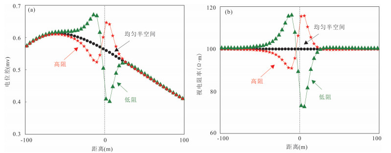
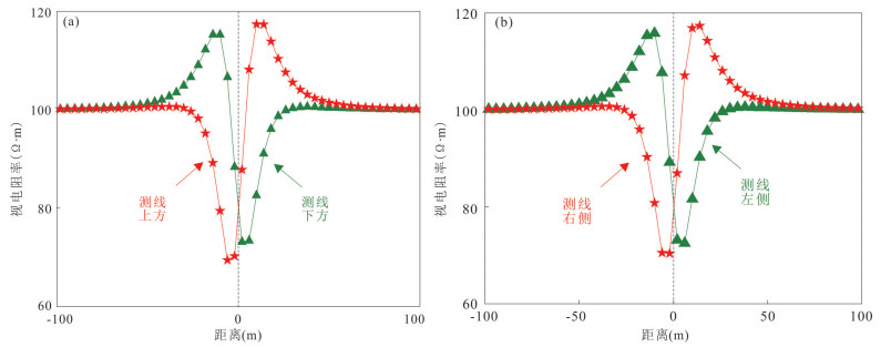
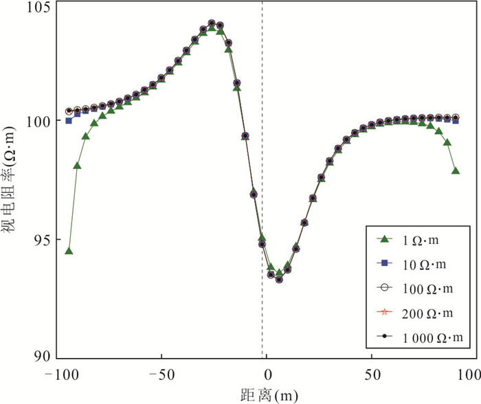
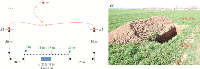
A ground-borehole direct current (DC) method which supplies DC power on the ground and receives potential difference in the borehole is presented, in order to achieve long-distance, high-precision advanced detection of hidden aquifers in front of coal mine tunneling roadways. The results of the model calculation show follows: (1) The apparent resistivity abnormal curve shows the abnormal characteristics of positive and negative alternations. The alternation order of high electrical resistivity and low electrical resistivity is opposite, the alternation order of positive and negative anomalies is determined by the relative position of the ground power supply point, survey line and abnormal target. (2) The distance between the ground power supply point and the abnormal body is negatively correlated with the abnormal response amplitude, and the abnormal body size is positively correlated with the abnormal width. (3) The anomaly center position, relative line orientation and anomaly body width can be interpreted according to the apparent resistivity curve, and a fast interpretation method is proposed. (4) A ground similarity simulation is tested to verify the theoretical response results and interpretation methods. The high and low electrical resistivity response characteristics are consistent with the theoretical results, and the abnormal target information determined by the fast interpretation method is basically consistent with the actual situation. Theoretical analysis and similarity test show that the ground-borehole DC method can effectively detect the electrical anomalies on the side of the borehole, it can realize "one hole and multi-use", and provide a new geophysical exploration method for long-distance and high-precision advanced fine exploration.
A ground-borehole direct current (DC) method which supplies DC power on the ground and receives potential difference in the borehole is presented, in order to achieve long-distance, high-precision advanced detection of hidden aquifers in front of coal mine tunneling roadways. The results of the model calculation show follows: (1) The apparent resistivity abnormal curve shows the abnormal characteristics of positive and negative alternations. The alternation order of high electrical resistivity and low electrical resistivity is opposite, the alternation order of positive and negative anomalies is determined by the relative position of the ground power supply point, survey line and abnormal target. (2) The distance between the ground power supply point and the abnormal body is negatively correlated with the abnormal response amplitude, and the abnormal body size is positively correlated with the abnormal width. (3) The anomaly center position, relative line orientation and anomaly body width can be interpreted according to the apparent resistivity curve, and a fast interpretation method is proposed. (4) A ground similarity simulation is tested to verify the theoretical response results and interpretation methods. The high and low electrical resistivity response characteristics are consistent with the theoretical results, and the abnormal target information determined by the fast interpretation method is basically consistent with the actual situation. Theoretical analysis and similarity test show that the ground-borehole DC method can effectively detect the electrical anomalies on the side of the borehole, it can realize "one hole and multi-use", and provide a new geophysical exploration method for long-distance and high-precision advanced fine exploration.


2024, 49(1): 335-346.
doi: 10.3799/dqkx.2022.142
Abstract:
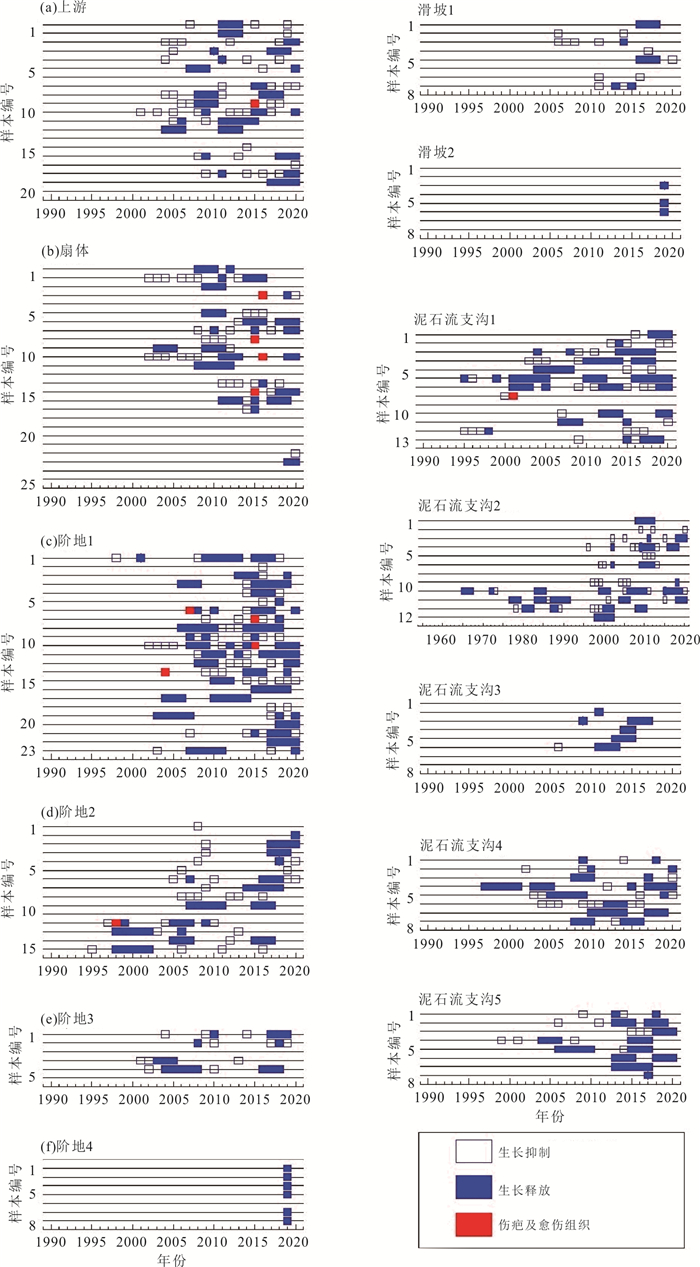
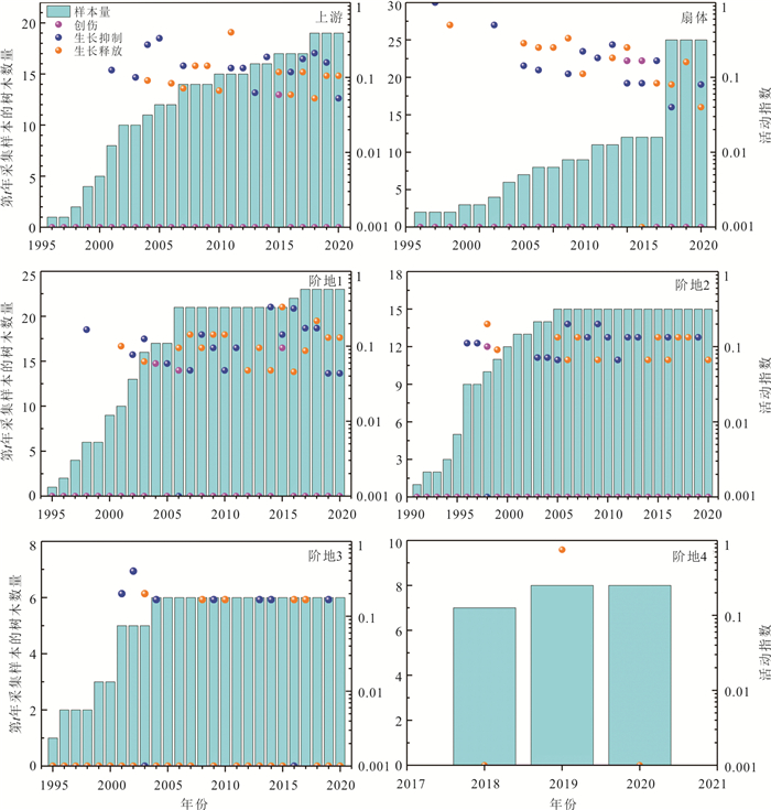
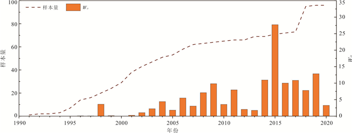
Polong gully is a primary tributary on the right bank of Palong Zangbu River. Four recorded debris flows in 1983, 1984, 1985 and 2015 repeatedly blocked the river and formed a 1 km-long barrier lake. But some individual debris flow was too small to flush out the gully and be recorded. Based on the method of dendrochronology and the analysis of damaged tissue, growth inhibition and release of tree rings, the temporal-spatial distribution of the main debris flow events, debris flows in the tributaries and landslides in the main gully in the past 40 years were reconstructed. From the intensity of tree growth disturbance, the inundate area of debris flow was discussed. The relationship between the occurrence time of debris flow and inundate area was further analyzed by the index of Wit. The results show that the accuracy of debris flow event dating reflected by dendrochronology was related to the debris flow scale. Extra-large-scale of debris flow would lead to the elimination of disaster historical memory of disturbed trees, which was not conducive to the debris flow dating. The debris flows in the tributaries and landslides in the main gully would disturb the debris flow dating in the main gully. Debris flows in the gully tributaries and landslides in the main gully occurring at the same time would increase the value of Wit, which was conducive to debris flows dating in the main gully.
Polong gully is a primary tributary on the right bank of Palong Zangbu River. Four recorded debris flows in 1983, 1984, 1985 and 2015 repeatedly blocked the river and formed a 1 km-long barrier lake. But some individual debris flow was too small to flush out the gully and be recorded. Based on the method of dendrochronology and the analysis of damaged tissue, growth inhibition and release of tree rings, the temporal-spatial distribution of the main debris flow events, debris flows in the tributaries and landslides in the main gully in the past 40 years were reconstructed. From the intensity of tree growth disturbance, the inundate area of debris flow was discussed. The relationship between the occurrence time of debris flow and inundate area was further analyzed by the index of Wit. The results show that the accuracy of debris flow event dating reflected by dendrochronology was related to the debris flow scale. Extra-large-scale of debris flow would lead to the elimination of disaster historical memory of disturbed trees, which was not conducive to the debris flow dating. The debris flows in the tributaries and landslides in the main gully would disturb the debris flow dating in the main gully. Debris flows in the gully tributaries and landslides in the main gully occurring at the same time would increase the value of Wit, which was conducive to debris flows dating in the main gully.


2024, 49(1): 347-358.
doi: 10.3799/dqkx.2022.197
Abstract:
Because traditional remote sensing geothermal anomaly detection methods usually yield many false anomalies and show low detection efficiency, a method based on evidence theory integrating multi-view remote sensing information is proposed. Based on the temperature information retrieved from remote sensing data, temperature anomalies are extracted from global, local block and elevation perspectives respectively. Then, the Dempster/Shafer evidence theory method is used to fuse the above three kinds of information to realize geothermal anomaly detection from multiple perspectives. Finally, buffer zones are established according to the fault structure, and the geothermal ranges are delineated by analyzing the anomalies in the buffer zone. Taking Qingdao City of Shandong Province as the research area, the proposed method was used to detect geothermal anomalies based on Landsat-8 satellite images, and 72.7% of the anomalies were distributed within the 1 km buffer zone. Eleven geothermal anomalies are delineated, of which three are proven geothermal fields or geothermal wells in Qingdao, which verifies the reliability of the method. Compared with traditional remote sensing geothermal anomaly detection methods, the proposed method can eliminate a lot of false anomalies by fusing global, local and elevation information, and improve the accuracy and reliability of results.
Because traditional remote sensing geothermal anomaly detection methods usually yield many false anomalies and show low detection efficiency, a method based on evidence theory integrating multi-view remote sensing information is proposed. Based on the temperature information retrieved from remote sensing data, temperature anomalies are extracted from global, local block and elevation perspectives respectively. Then, the Dempster/Shafer evidence theory method is used to fuse the above three kinds of information to realize geothermal anomaly detection from multiple perspectives. Finally, buffer zones are established according to the fault structure, and the geothermal ranges are delineated by analyzing the anomalies in the buffer zone. Taking Qingdao City of Shandong Province as the research area, the proposed method was used to detect geothermal anomalies based on Landsat-8 satellite images, and 72.7% of the anomalies were distributed within the 1 km buffer zone. Eleven geothermal anomalies are delineated, of which three are proven geothermal fields or geothermal wells in Qingdao, which verifies the reliability of the method. Compared with traditional remote sensing geothermal anomaly detection methods, the proposed method can eliminate a lot of false anomalies by fusing global, local and elevation information, and improve the accuracy and reliability of results.
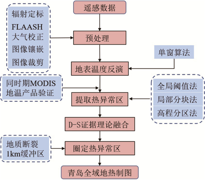


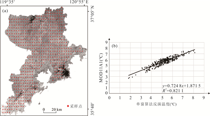
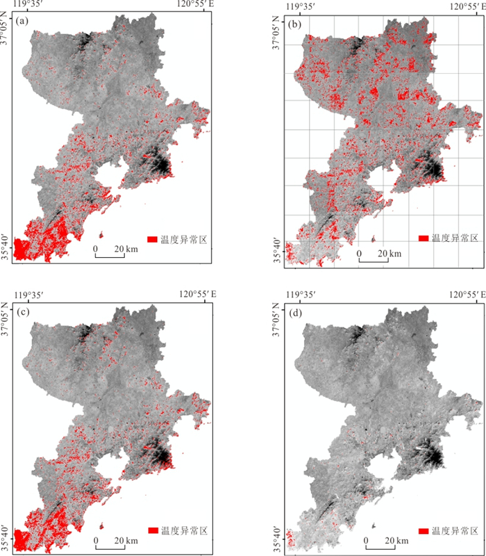


2024, 49(1): 359-374.
doi: 10.3799/dqkx.2022.124
Abstract:
As a record of the evolution of the Martian geological environment, the widely-distributed valley networks on the surface of Mars are of great significance to the understanding of the environmental changes, paleoclimate, and habitability of Mars over geologic time. With the development of China's Mars exploration program, it is important to understand the research status of this one of the most extensive Martin fluvial landforms in detail. In this paper, we reviewed the research progress on the exploration history, morphological classification, spatial and temporal distribution, and formation hypotheses of Martian valley networks, on the basis of which, we summarized the main problems and controversies in the current research, and suggested that the future studies may focus on the identification and analysis of valley networks' erosional sediments, the reconciliation of the geological observations and theoretical modeling, and analog studies between Martian valley networks and terrestrial counterparts.
As a record of the evolution of the Martian geological environment, the widely-distributed valley networks on the surface of Mars are of great significance to the understanding of the environmental changes, paleoclimate, and habitability of Mars over geologic time. With the development of China's Mars exploration program, it is important to understand the research status of this one of the most extensive Martin fluvial landforms in detail. In this paper, we reviewed the research progress on the exploration history, morphological classification, spatial and temporal distribution, and formation hypotheses of Martian valley networks, on the basis of which, we summarized the main problems and controversies in the current research, and suggested that the future studies may focus on the identification and analysis of valley networks' erosional sediments, the reconciliation of the geological observations and theoretical modeling, and analog studies between Martian valley networks and terrestrial counterparts.