2024 Vol. 49, No. 2
 PDF 4074KB
A key challenge in earthquake early warning (EEW) research is to predict whether the final intensity at a station during an earthquake will exceed 6 degrees using only a small amount of P-wave information received by the station. In this paper, we propose a real-time intensity threshold discrimination model based on Extreme Gradient Boosting Tree (XGBoost). The model uses five features calculated from the information within 3 seconds after receiving P-waves as input features, and uses the threshold of whether the final instrumental seismic intensity at the station will exceed 6 degrees. A total of 4 353 acceleration records from 460 earthquakes recorded by the Japanese K-NET seismic network from 1996 to 2022 were used to establish the XGBoost-based real-time intensity threshold discrimination model (XGBoost-ITD). The results indicate that the model's discrimination accuracy rate is 93% for low intensity and 88% for high intensity. Compared with the support vector machine classification method and the traditional method under the same dataset, the XGBoost method shows higher discrimination accuracy.


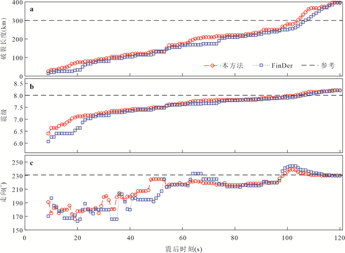
By introducing the real-time estimation method of seismic source rupture characteristics in to an earthquake early warning system (EEWS), we can effectively overcome the shortcomings of the traditional point-source-model-based estimation of target warning intensity and potential damage zones, and improve the disaster mitigation effectiveness of an EEWS. The real-time performance of existing methods is usually only at the minute level, which cannot meet the high timeliness requirements of EEWSs. In this work, we developed a real-time method to continuously estimate source rupture characteristics considering P-wave warning parameters. This method is an improvement of the finite rupture template matching method, namely FinDer. The system test results show that the results obtained using this method are about 3 s faster compared to the FinDer algorithm results at the same moment after the earthquake, and the results of individual earthquake cases are 5 s faster. Additionally, at the early stage of rupture, there are large fluctuations in the obtained strike θ due to the influence of seismic radiation diversity, site, propagation path and other factors. As the rupture continues, θ will gradually converge to the reference value. Moreover, for earthquakes of magnitude less than M7.0, relatively stable rupture characteristic parameter results can be obtained 6-10 s after the earthquake origin, while for M7.0+ earthquakes, it takes longer time, especially for mega-earthquakes such as the Wenchuan M8.0 event, whose results need to be gradually stabilized only at 40 s after the origin with relatively sparse station coverage.


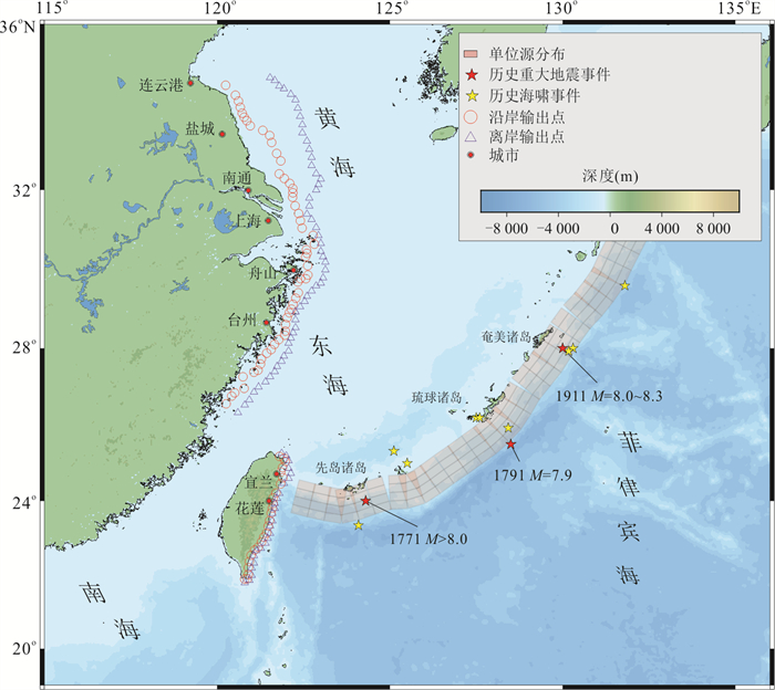
In order to improve tsunami mitigation capabilities along the coast of China and to increase public awareness of tsunami hazards, this paper systematically analyses the potential threat of tsunamis caused by earthquakes in the Ryukyu Trench subduction zone off the southeast coast of China and the eastern part of Taiwan Province. We quantitatively assess their tsunami hazard based on a probabilistic approach of logic tree and Monte Carlo simulation. Considering the scarcity of historical earthquake records in the Ryukyu Trench, we determined the maximum magnitude of potential earthquakes in the region based on the dynamic parameters of the subduction zone. At the same time, a logical tree of tsunami source parameters was constructed to analyse the uncertainty of the assessment results by integrating previous research results on paleotsunamis in the region. The results show that the maximum tsunami wave amplitude can reach 2-3 m around Yilan and Hualien counties in eastern Taiwan Province in the return period of 2000 years; the maximum tsunami wave amplitude can also reach about 0.6 m and 0.8 m in Shanghai and Zhoushan at the same time. Therefore, although there are almost no catastrophic tsunami events in the historical record of the Ryukyu Trench, its tsunami threat to the southeast coast of China, especially the eastern part of Taiwan, cannot be ignored.


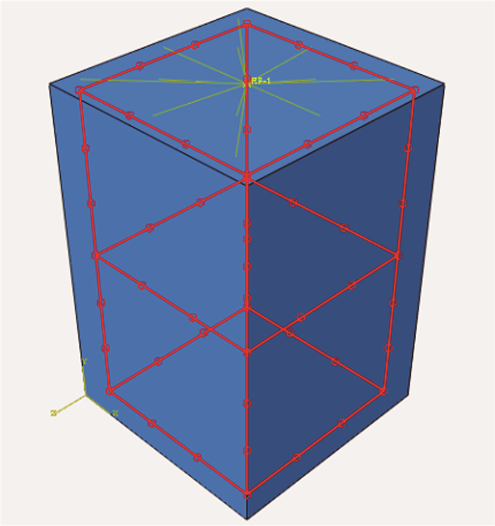
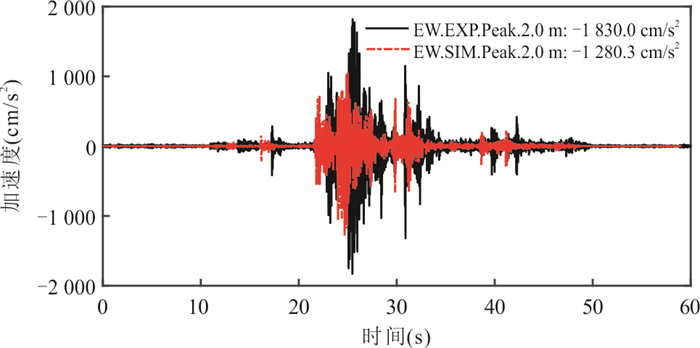
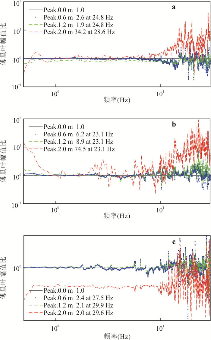
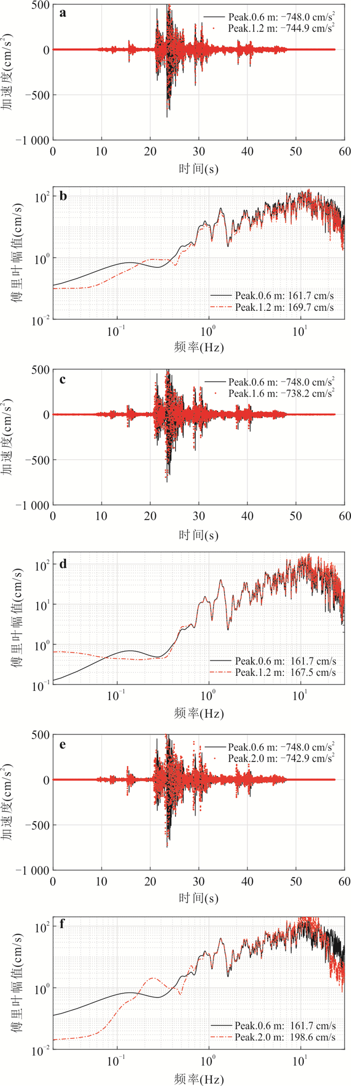
The accelerometer for strong motion observation is usually fixed on the concrete pier at a certain height, and the ground motion of ideal free field cannot be reflected completely. In order to study the influence of pier height on the strong motion records, three piers with different heights and the same cross-sectional dimension are designed, and the effect of the pier height on the time-frequency characteristics of the strong motion records is analyzed through seismic simulation shaking table tests, bedrock records are selected as the ground motion input, and numerical simulations are applied to verify the research results, at the same time, the strong motion records of station 51SMM in Luding earthquake is modified to standard pier by filtering. It shows that the effect of the piers on the horizontal PGA, PGV and PGD increases with the increasing height, while the PGA and PGV amplitudes decrease for the vertical ground motion. Fourier amplitude spectrum in the range of 0.5-7 Hz shows that 0.6 m and 1.2 m high piers have less influence than other frequency bands, while 2.0 m high piers have the greatest influence. The experiments above show the filtering effect is better for modifying the pier with different heights, and it is better used in strong motion records of station coded by 51SMM.The piers with the height exceeding 1.2m should be avoided for strong motion observations.


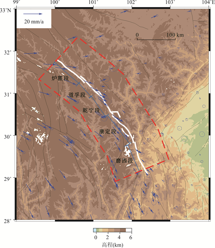
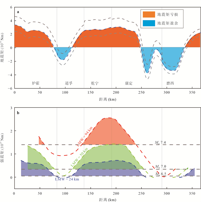
On September 5, 2022, an M6.8 earthquake located at the Moxi fault at the southern end of the Xianshuihe fault zone. The seismogenic mechanism of this earthquake and whether large earthquakes will occur in this fault section in the near future are scientific issues worth attention. This paper attempts to explain the seismogenic mechanism of the earthquake and the potential seismogenic potential of the Xianshuihe fault zone in the future from the perspective of the accumulation and release of seismic energy. By comparing the temporal and spatial distribution of seismic moment accumulation and release, it is found that earthquakes mostly occur in the period of seismic moment deficit, and there is a tendency to fill the moment deficit. In addition, there are three significant moment deficit segments in Xianshuihe fault zone. All of these moment deficit fault segments have the potential to produce earthquakes of magnitude 6.5 or greater. After the 1786 Kangding M 7.6 earthquake, the accumulation of 200 years is enough to produce an earthquake of M 6.5 or above. The Luding M 6.8 earthquake only released a small part of the moment deficit on the Moxi fault, and there is still a possibility of a major earthquake on this fault section in the future.


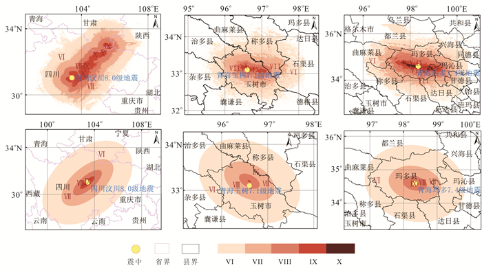
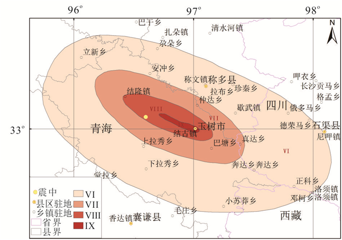
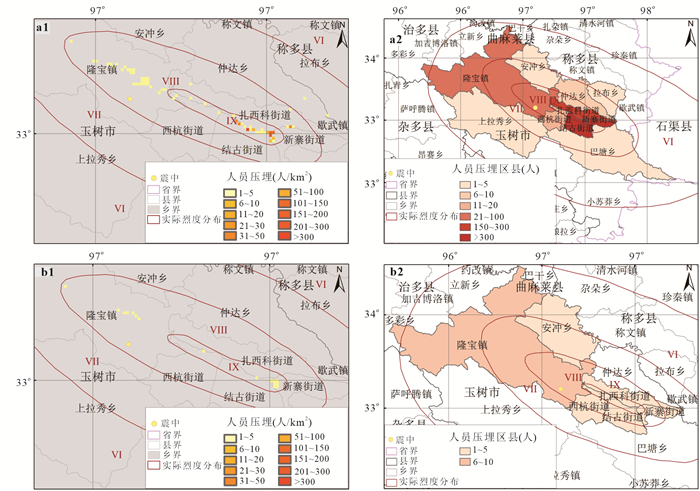
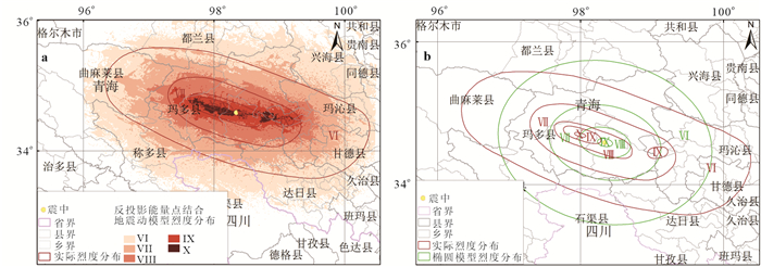
Effective estimation of buried personnel after earthquake is the basis for scientific and orderly emergency response and rescue.Seismic intensity, an imperative data for rapid assessment of post⁃earthquake personnel buried, plays a crucial role in ensuring the reasonability and accuracy of evaluation results. With the help of intensity calculation results generated in a ground motion attenuation model based on back⁃projection energy point & shortest distance of earthquake fault, as well as the most widely used elliptical attenuation model at present, this paper firstly carries out a rapid evaluation of buried personnel in three earthquakes with a magnitude of seven or above occurred nearby Gansu province in recent years and subsequently performs a comparison with the actual situation. Compared with the elliptical attenuation model of earthquake intensity, the intensity calculation results based on the back⁃projection energy point & seismic parameter attenuation model are more capable of determining the distribution of severely afflicted areas and extremely severely afflicted areas accurately and finely, and perfecting the reasonability and accuracy of the total number of personnel buried and classification of key buried areas. The back⁃projection energy point & seismic parameter attenuation modelhas proved itself with excellent applicability in the rapid evaluation of buried personnel in destructive earthquakes with a magnitude of seven or above, and with fine timeliness to meet the actual needs of earthquake emergency response and emergency rescue.


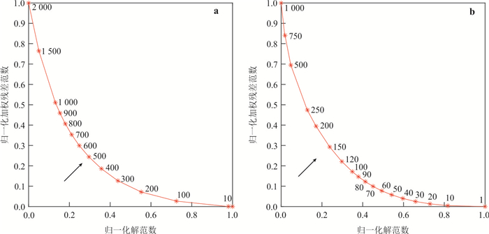
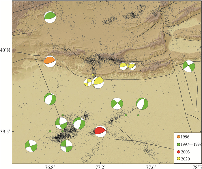
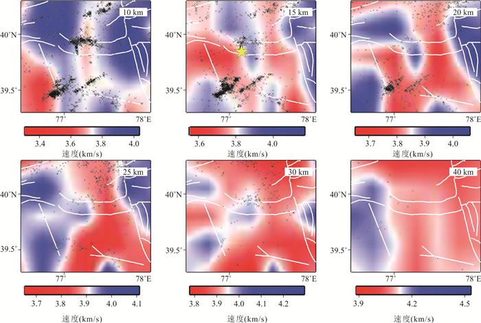
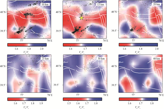
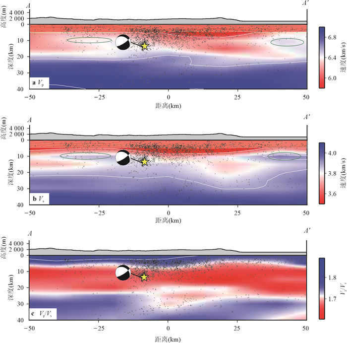
In order to discuss in detail the relationship between the fine velocity structure of the upper crust and seismic activity in the Jiashi area, this paper used the double⁃difference tomography method to obtain the earthquakes precise relocation results and high⁃resolution three⁃dimensional VP and VS velocity structuresin the Jiashi region(76.5°E⁃78.0°E, 39.3°N⁃40.3°N)with the seismic phase observation and broadband waveform provided by the Xinjiang Digital Seismic Network since 2009. The full moment tensor solutions of earthquakes with MS≥ 5.0 in the 2020 MS6.4 Jiashi earthquake sequence arecalculated, and the spatiotemporal distribution characteristics of earthquakes in this region are comprehensively studied.Theresults indicate that the earthquake distribution after relocation in this area has a poor correlation with distribution of the known faults. The 2020 MS6.4 Jiashi earthquake sequence was distributed in two dominant striking direction: NNW and near EW. The aftershocks were mainly distributed on and near the Ozgertau fault with near EW⁃striking, about 20km away from the mainshock, within 48 hours after the earthquake. The full moment tensor solutions of the four moderately strong earthquakes in the sequence show significant non double⁃couple components, all of which are compressive fractures with reduced volume. The results show that there is obvious heterogeneity in the crustal velocity structure in the Jiashiarea., the epicenter of the 2020 MS6.4 Jiashi earthquake is located within high P⁃velocity zones, the margin of hightS⁃velocity zones and low VP/VS, zones, there are large⁃scale S⁃wave low velocity anomalies in the middle and lower crust. Integrated with the regional tectonics and previous research results, we believe that the seismogenic structure of the MS6.4 mainshock in 2020 is the near EW buried nappe blind reverse fault in the Kepingtag nappe, and its conjugate NNW buried fault also participated in the seismogenic process of the entire MS6.4 Jiashi earthquake sequence.The frequent occurrence of strong earthquakes in Jiashi area is the result of the tectonic movement of the Tarim Basin, which continues to subduct and compress towards the southern Tianshan Mountains, triggering the activities of nappe structures and several hidden faults at the junction of basin and mountain. The strong lateral heterogeneity of fine velocity structure also leads to the diversity of focal mechanisms.


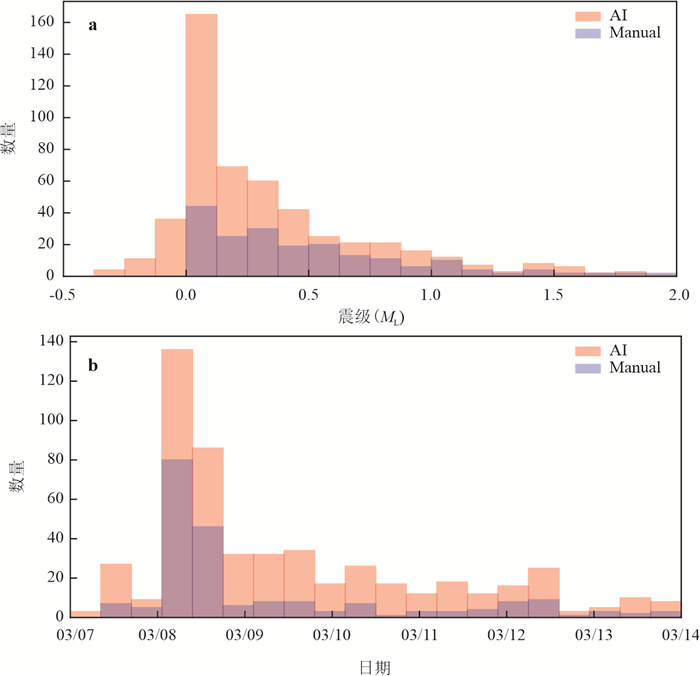
With the construction of the "National Seismic Intensity Rapid Reporting and Early Warning" project, acceleration records data will be increasingly applied in earthquake science research. However, most current earthquake detection models use velocity records for training, which results in poor detection performance for acceleration records. This study utilized seismic records from the Guangdong Earthquake Network to train the PhaseNet_GD model for detecting velocity records and the PhaseNet_ITS model for detecting acceleration records.Based on this, a new intelligent earthquake data processing system was developed by combining the GaMMA, phase association method, and the HYPOSAT, earthquake location method. This system was used to process the 2023 ML 4.8 earthquake sequence in XinfengjiangReservoir, Heyuan, and detected events 3.8 times more than the manual catalog, with a matching rate of 93.2% and a false detection rate of 0.38%. This system can provide technical support for reservoir seismic monitoring and real⁃time data processing of regional earthquake networks.


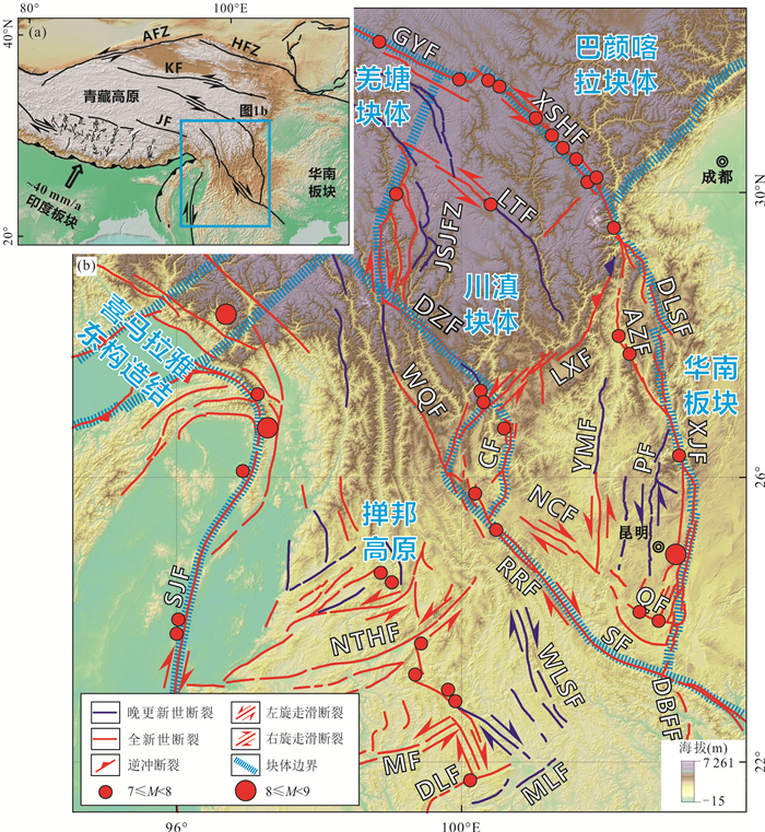
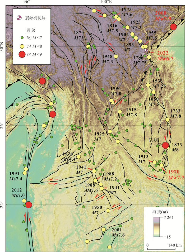
The southeastern margin of the Tibetan Plateau is an ideal experimental field to test the evolutionary model of the Tibetan Plateau and one of the most seismically active regions in the world. In this paper, we review the decadal and 10, 000⁃year⁃scale slip habits of the major active faults on the southeastern margin of the Tibetan Plateau and the 100⁃year⁃scale regional seismic activity, combined with the million⁃year time⁃scale chronology studies, we think the internal material of the Tibetan Plateau gradually flowed out to the east and was blocked by the Sichuan Basin, turning to the southeastern margin area for clockwise rotational movement since the middle and late Miocene. In the Late Quaternary, the upper crustal deformation in the southeastern margin has changed from being concentrated in large strike⁃slip boundary faults and thrust fold belts to being diffusely distributed to secondary faults in the region, forming the kinematic characteristics of clockwise rotation around the eastern Himalayan syntaxis with the Xianshuihe⁃Xiaojiang Fault Zone and the Sagaing Fault Zone as boundaries. Accordingly, the deformation of the southeastern margin of the Tibetan Plateau can be divided into two stages. The deformation of the early Miocene period was concentrated in large boundary faults, which conforms to the deformation of rigid blocks, and turned into diffuse continuous deformation in the late Quaternary. Based on the comparison of horizontal slip rate, seismogenic capacity and seismic activity, the active faults on the southeast edge of the Tibetan Plateau can be roughly divided into three levels. The first⁃tier faults are the boundary fault Xianshuihe⁃Xiaojiang fault zone and Sagaing fault zone, with horizontal slip rates ≥10 mm/a, capable of occurring earthquakes of M 8 and above alone, and can continuously generate strong earthquakes of M 7⁃7.9, which are the first⁃tier tectonic frame since the Late Quaternary in the southeastern margin; the second⁃tier faults can control the strongly active tectonic units in the southeast margin, with horizontal slip rates ~3⁃6 mm/a, generally capable of occurring earthquakes of M 7⁃7.9, and can continuously generate earthquakes of M 6⁃6.9; the horizontal slip rate of Level 3 faults is generally ≤2 mm/a, they are only capable to generating earthquakes less to M 7, and are generally smaller in scale but more numerous. In addition, the Late Quaternary deformation characteristics of the Chuandian Block have changed from the original slip movement along the large boundary faults to the rotation, translation and differential uplift of the secondary active blocks around the Xianshuihe⁃Xiaojiang Fault Zone.


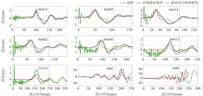
To issue tsunami warnings in real⁃time, complex earthquake sources are usually simplified to uniform slip models for tsunami prediction. Althought this approach of simplification is widely used, its accuracy in predicting tsunami waves in actual events hasnot been fully evaluated and recognized. In this paper, a finite⁃fault model and various uniform slip models are constructed for the 2021 Mw 8.2 Alaska Peninsula earthquake, and their prediction errors for tsunami waves are compared. The finite⁃fault model inverted from tsunami datareveals that the coseismic slip of this event was distributed over a depth range of 15 to 40 km, and the ~6m maximum slip occurred near the hypocenter. Besides, the optimum uniform slip model obtained from global search provides very similar tsunami predictions to those given by the finite⁃fault model, both of which agree well with the observations. Two uniform slip models located at the gCMT centroid but using different scaling relations yield almost the same far⁃field waveforms.Results of this study show that the optimum predicting ability of uniform slip modelis almost equivalent to that of the finite⁃fault model. The uniform slip models based on gCMT centroids and scaling relations are relatively reliable for far⁃field tsunami warning, and difference in scaling relations may not significantly impact the far⁃field predictions.


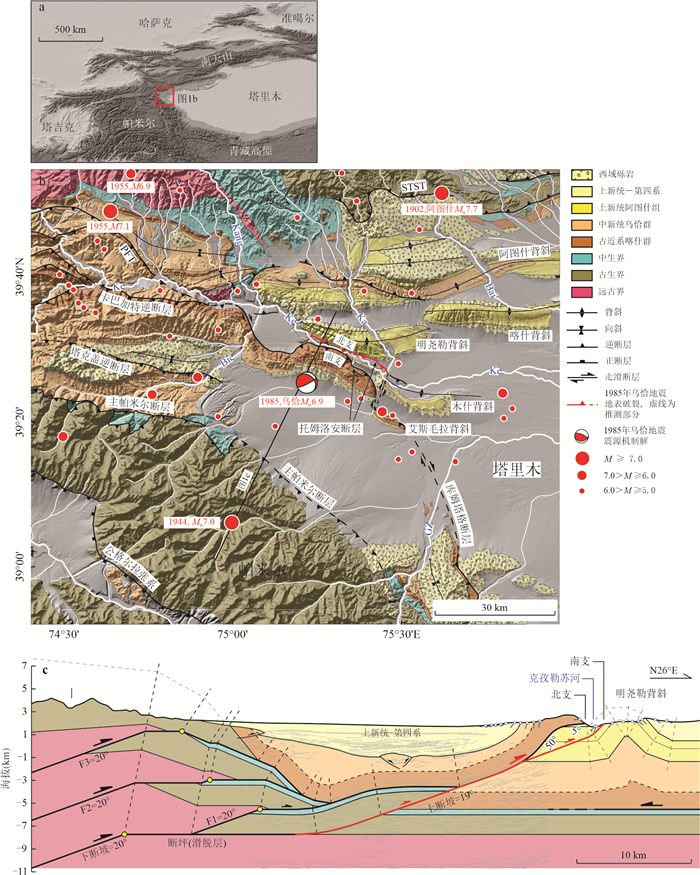
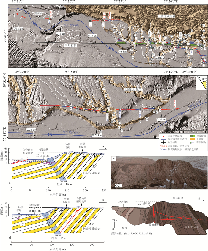
The 23 August 1985 Wuqia Mw 6.9 earthquake in Xinjiang Province, represents one of the strongest events in the Pamir-Southern Tian Shan convergence zone during the instrumental period. It was also one of the few events that produced clear coseismic surface rupture in the mountain ousforeland region. Based on previous studies of


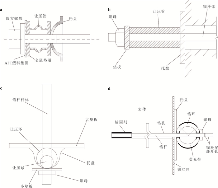
Energy dissipation bolt has better support and fault tolerance when applied to slope engineering, foundation pit engineering and roadway engineering, and has been widely used in ground and underground engineering. This paper systematically introduces the research and development status of traditional energy dissipation and seismic bolt. According to whether energy dissipation and seismic bolt can self-reset after the external load disappears, it is further divided into non-self-resetting bolts and self-resetting bolts, and the working mechanism, advantages and disadvantages of several typical anti-seismic bolts are analyzed. On this basis, the main problems of the existing energy dissipation and seismic bolts technology are further summarized, including lack of verification of the mechanical properties of energy dissipative anchors, significant differences in the mechanical response of anchors due to different load mechanics, and the inability of existing energy dissipative anchors to adapt to the dynamic deformation of geotechnical bodies. Finally, based on the characteristics of self-resetting seismic structure, a new multi-stage energy dissipation and seismic bolt with self-resetting structure is proposed.This bolt has the characteristics of multi-stage buffer energy dissipation and can realize the effect that the deformation of its energy dissipating parts can be recovered when the external load is reduced or disappeared, which can provide effective support force for slope, tunnel, mine tunnel and other support engineering in strong seismic areas, blasting areas and high ground stress areas continuously.


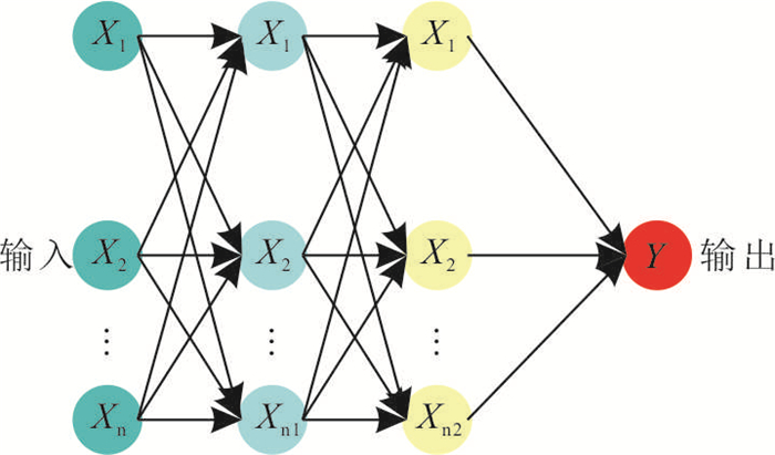
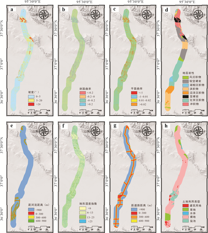
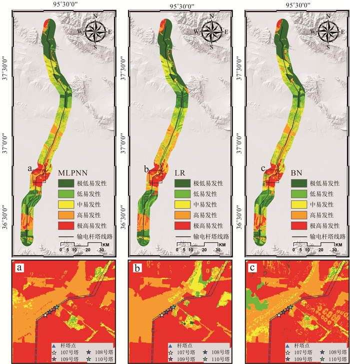
The 750 kV Chaiyu transmission line across the Qarhan Salt Lake area is an important part of the energy transportation channel in the western part of the country. Affected by the special geological environment and human activities in the salt lake area, some tower foundations have uneven settlement, which seriously threatens the safe operation of the transmission line. Aiming at the problem of deformation and failure of tower foundation in salt lake area, small baseline integrated aperture radar interferometry (SBAS-InSAR) technology was used to carry out remote sensing interpretation of Sentinel 1A data in 2018 before the deformation and instability of tower foundation, and the distribution of ground subsidence in salt lake area was obtained. Based on the frequency ratio method, eight evaluation factors with strong correlation with land subsidence were selected to construct the evaluation index system of land subsidence susceptibility in the salt lake region. The multi-layer perceptron neural network(MLPNN), logical regression(LR) and Bayesian network(BN) were used to compare and analyze the evaluation effect and accuracy of land subsidence susceptibility in the salt lake region. The evaluation results show that the evaluation accuracy of MLPNN, LR and BN is high, which are 0.85, 0.84 and 0.82, respectively. This shows that the method of combining the sample data of land subsidence obtained by remote sensing interpretation with machine learning is an effective means for evaluating the susceptibility of ground subsidence of transmission line towers in the salt lake region. At the same time, the evaluation results can provide reference for transmission line tower monitoring, operation management and new tower location.


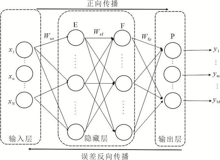
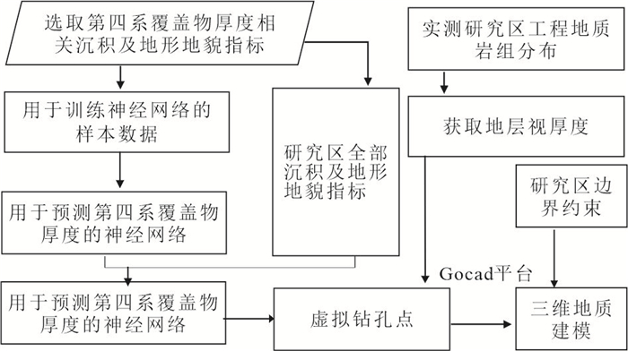
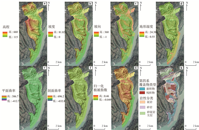
Fine investigation and assessment of geological disaster risk is an important part of prevention and control of geological disaster reduction at present. The development of 3D slope geological modeling technology provides a new idea for detailed investigation and assessment of landslide hazard risk, which can greatly improve the efficiency and assessment accuracy of landslide hazard investigation in the region.In this paper, based on Skua-Gocad platform, three-dimensional geological modeling technology of regional slope is studied for two modules of Quaternary cover and underlying bedrock. Taking Dazhou Town, Wanzhou District, Chongqing as an example, BP neural network model is used to predict the thickness of Quaternary cover by building a multi-dimensional nonlinear network of Quaternary cover thickness and geological environment indicators in the study area.Combined with the field survey data, the method is verified, and the prediction accuracy of Quaternary cover thickness based on BP neural network reaches 91.49%. On this basis, a 3D geological model is built, which has good visualization effect and ensures the reliability of data.It overcomes the shortcoming of traditional Kriging interpolation method that can't reflect geological environment factors, and solves the difficult problem of prediction of Quaternary cover thickness in regional scope.


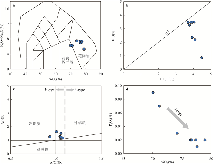
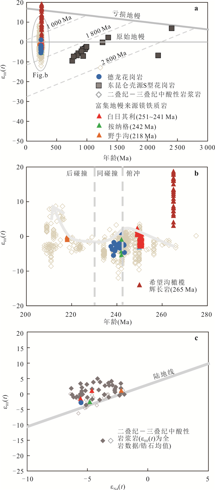
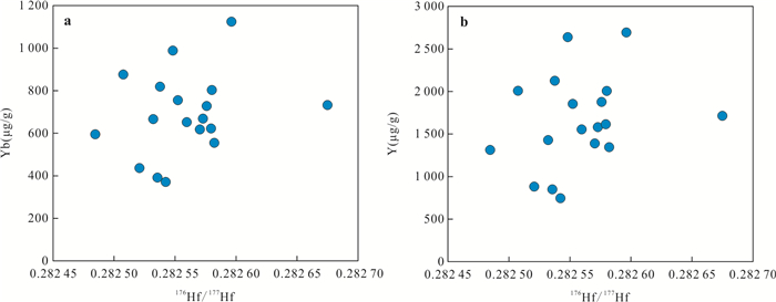
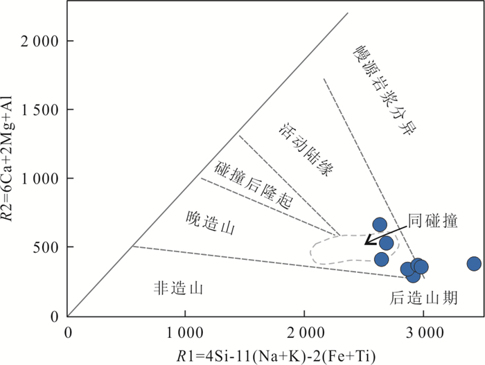
The East Kunlun Orogen is an important part of the Paleo-Tethys domain. The closure time of the Paleo-Tethys Ocean and the reason for decoupling Nd-Hf isotopes of Permian-Triassic magmatic rocks are still controversial. Zircon chronology and whole rock elemental and isotopic analyses have been carried out on the Delong granite in the East Kunlun Orogen. The results show that the Delong granite was emplaced in the Middle Triassic and belong to metaluminous to weakly peraluminous high silica I-type granite, with low Sr/Y and La/Yb ratios, similar to normal island arc magmatic rocks. Isotopic data show enriched Sr-Nd and enriched to depleted zircon Hf isotopic signatures for the Delong granite. These data, together with petrography, indicate that the Delong granite comes from the mixed melting of new and old crust or the remelting of rocks from mixed source areas such as enriched mantle and oceanic plate (mixture of basalt crust and sediments). These special sources contribute to widespread decoupling of εNd(t) and εHf(t) of the Delong granite and even regional contemporaneous intermediate-acid magmatic rocks. Based on the above conclusions and the geological and geochemical characteristics of the rocks regionally, it is inferred that the Paleo-Tethys Ocean was closed at about 240 Ma.


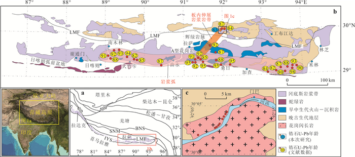
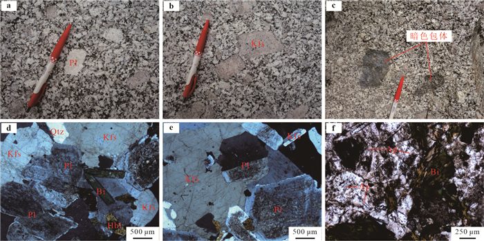
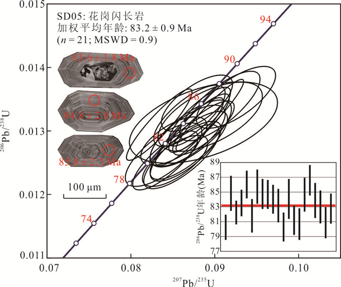
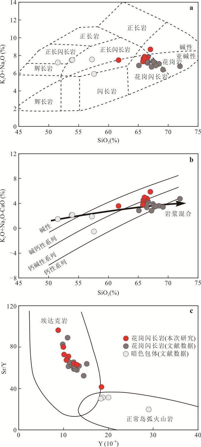
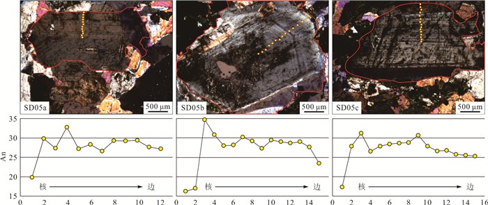
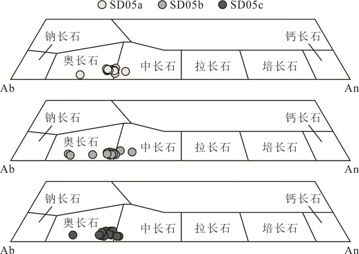
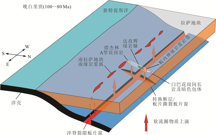
In order to discuss thedynamic mechanism of Late Cretaceous magmatism in the Lhasa block, this paper carried out petrographic, chronological, geochemical and mineral chemistry studies on the Menba granodiorites in the southern margin of the central Lhasa block. LA-ICP-MS zircon U-Pb dating indicates that the Menba granodiorites emplaced in the Late Cretaceous (83.2 Ma±0.9 Ma). The geochemical characteristics show that the Menba granodiorites are adakitic rocks. Electron microprobe data reveal that plagioclase belongs to andesine and oligoclase (An=16.2-34.7). This paper believes that the parent magmas of the Menba granodiorites may be a result of magma mixing between mantle- and crust-derived magmas and the mantle-derived magma underplating may have led to partial melting of the thickened lower crust and then reactions between them. Combined with the diagenetic environment and spatial distribution characteristics of the Late Cretaceous magmatic rocks. This paper concludes that the Late Cretaceous magmatism in the southern Lhasa block was mainly controlled by the ridge subduction of the Neo-Tethys. The upwelling of asthenosphere mantle along the slab window of the mid-ocean ridge induced the Late Cretaceous large-scale magmatism in the southern margin of the south Lhasa block, while the upwelling of asthenosphere material along the tear slab window of transition fault that cuts the mid-ocean ridge induced the small-scale intraplate magmatic belt, which approximately perpendicular to the large-scale magmatism in the southern margin of the south Lhasa block.


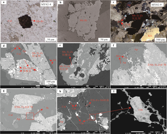
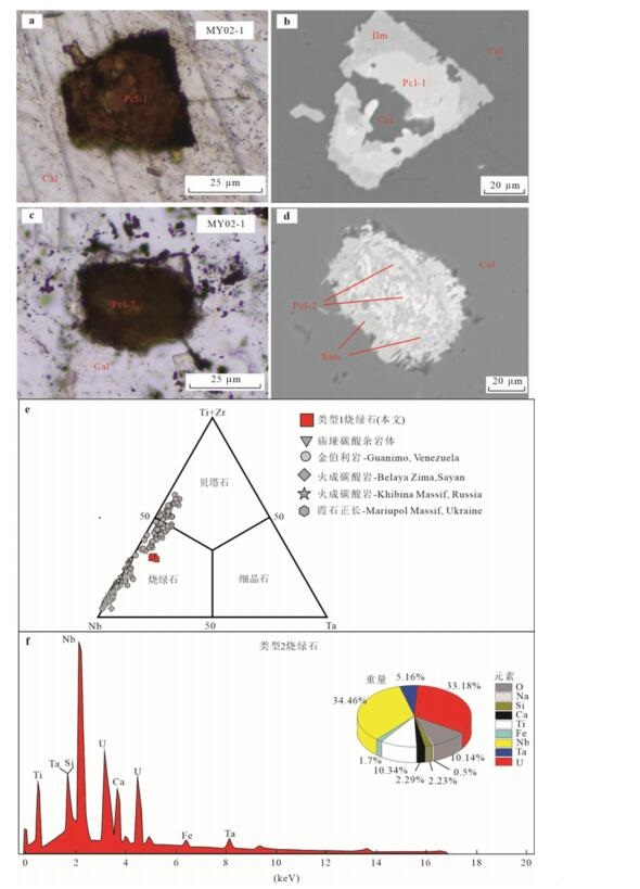
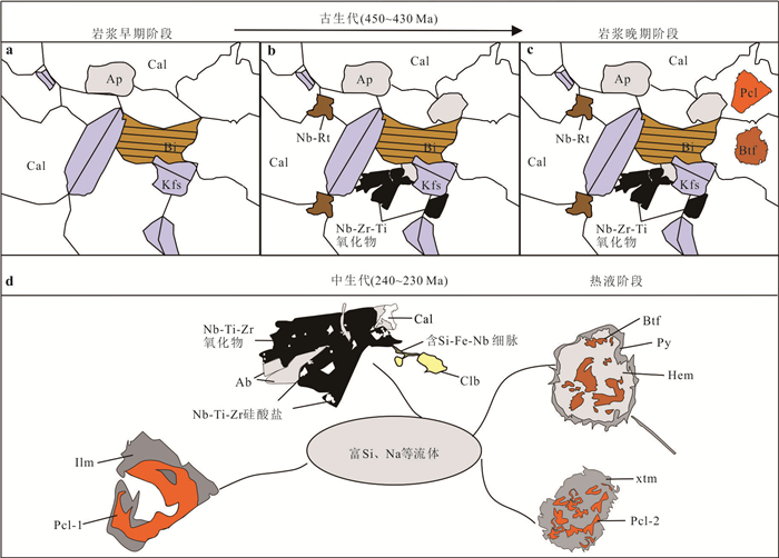
The Miaoya carbonatite complex is located in the southwestern margin of the Wudang Terrane in South Qinling, central China. It mainly consists of carbonatites and syenites with abundant REE and Nb mineralization, hosting the second largest carbonatite-related Nb deposit in China. Although the Miaoya REE mineralization process has been well studied, the Nb enrichment mechanism was poorly understood. Hereby, an integrated investigation, involving petrology, mineralogy and mineral chemistry was conducted on the Miaoya carbonatite complex. The Nb-bearing phases of the Miaoya complex mainly include Nb-rutile, Nb-Ti-Zr bearing minerals, ferrocolumbite, U-rich pyrochlore and betafite. Both of Nb-rutile and Nb-Ti-Zr oxides occur as euhedral crystals with high Nb2O5 contents (1.10%~3.35% and 8.58%~18.64%, respectively). Nb-Ti-Zr silicate are embedded along the cracks or edges of Nb-Ti-Zr oxides and are in close association with albite veinlets, with low Nb2O5 contents (1.75%~6.00%). Anhedral and fine-grained ferrocolumbite is closly symbiotic with Nb-Ti-Zr oxides and shows high Nb2O5 and FeO contents (72.30%~75.75% and 18.52%~18.81%). U-rich pyrochlore occur as an hedral grains, irregularly replaced by xenotime or hematite, with relatively high Nb2O5 and UO2 contents (35.42%~36.45% and 25.68%~26.76%, respectively), high A-site vacancy values (0.55~0.74 apfu) and low Na2O and F (below detection line and 0.32%~0.79%). Betafite occur as remnant or elliptic pseudocrystals, spatially associated with hematite and pyrite, and significantly enriched in Nb2O5、UO2 and TiO2. Summarily, we initially propose that the enrichment of Nb in the Miaoya complex was controlled by both magmatic and hydrothermal processes. In an initial Nb-rich carbonatitic magma system, prolonged fractionation of Nb-poor minerals led to the concentration of Nb in the residual melts, as documented by Nb-rutile, Nb-Ti-Zr oxides, uranpyrochlore and betafite. Hydrothermal (Na, Si and Fe)-rich fluids largely replaced the early-crystallized Nb-bearing minerals, subsequently remobilized, transported and precipitated as second Nb-rich minerals (e.g., Nb-Ti-Zr silicate and ferrocolumbite).


The dry-wet cycle has a serious impact on the grotto sandstone, causing a large number of cantilever cracking damages to the grottoes. Through indoor dry-wet cycle test, Brazil split test and strain field analysis methods, the strength and mechanical parameters of the sample under different numbers of dry-wet cycles are analyzed and studied. The internal friction angle φ, cohesive force c, microstructure, strain field characteristics The law of change. The study found that with the increase of the number of dry-wet cycles, clay minerals gradually lost and the structure became loose. The weakening of the cementation between mineral particles led to the decrease of the cohesive force c of sandstone. At the same time, due to the change of the particle shape and pore structure of the sandstone, the contact relationship between the particles was changed, which led to the reduction of the internal friction angle φ, and finally caused the deterioration of its tensile and fracture mechanical properties. Finally, combining the failure process and crack distribution of the sample, two failure modes of the grotto sandstone under different dry-wet cycles are summarized.


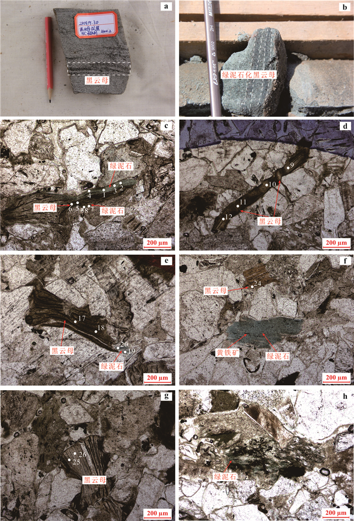
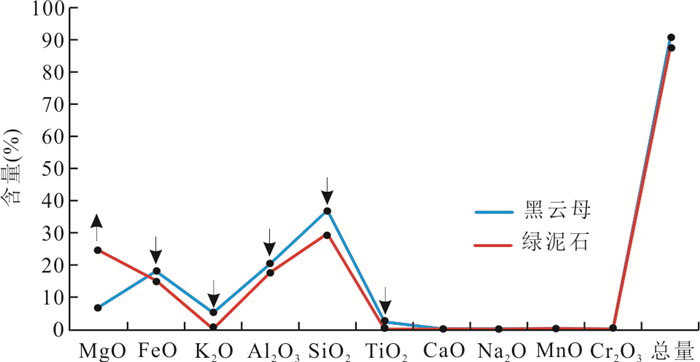
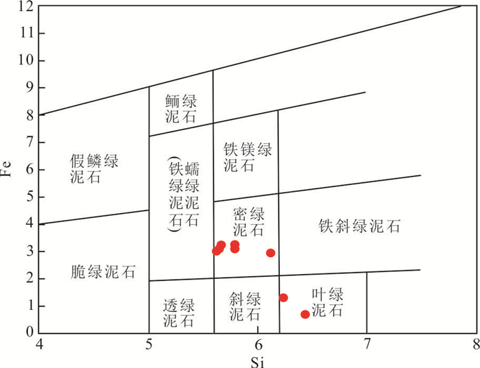
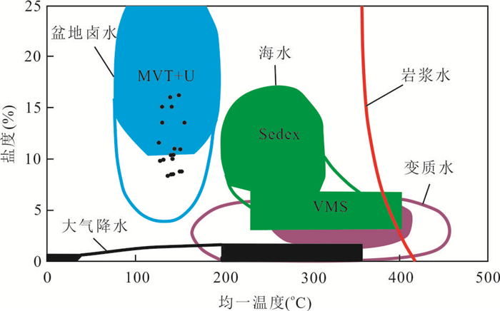
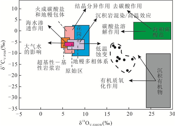
Uranium (U)-concentrated areaof northern Ordos Basin is one of the most important sandstone-type U deposits in north China. In order to find out the Umetallogenic effect of hydrothermal fluid transformation in this area, the mineral-geochemical characteristics of biotite chloritization process were studied by thin section identification, scanning electron microscopy (SEM) and electron probe (EMPA). The results show that biotite in sandstone-type U deposits in north Ordos Basin mostly occurs chloritization, which is often altered and metasomatized along the cleavage and edge of biotite, accompanied by the release of Si, Fe, Ti, U and other elements. Hydrothermal fluid related to altered biotiteis basin brine with hydrocarbon and has the characteristics of alkaline–reducing and medium-low temperature (137.3~208.3 ℃). Moreover, U-rich source rocks were widely developed in the deep part of the Ordos Basin and the hydrocarbon expulsion and emigrated U can migrate along the faults and other channels with the geothermal brine in basin under the action of continuous burial and thermal events, which can theoretically provide deep U sources forsandstone-type U deposits in this area. When it migratedlaterally to ore-bearing layer, the U-rich hydrothermal fluid was formed by extracting U fromthe ore-bearing sandstones and dissolving the U minerals formed in the early stage. U is reactivated and migrated in the form of organic complexes or organic colloids in hydrothermal fluid and precipitated in the form of coffinite around pyrite, organic matter and calciteat the changing parts of reducing capacity, temperature, pressure and pH, resulting, which provides a basis for the Umetallogenic effect of hydrothermal fluid transformation in sandstone-type U deposits. In addition, the above fluid-rock reaction was easy to cause biotite chloritization, forminghydrothermal altered mineral assemblages, such aschloritized biotite-coffinite, chloritized biotite-pyrite-coffinite, chloritized biotite-anatase-coffinite, anatase-coffinite, which also provides direct evidence for the participation of hydrothermal fluid in sandstone type U deposits.


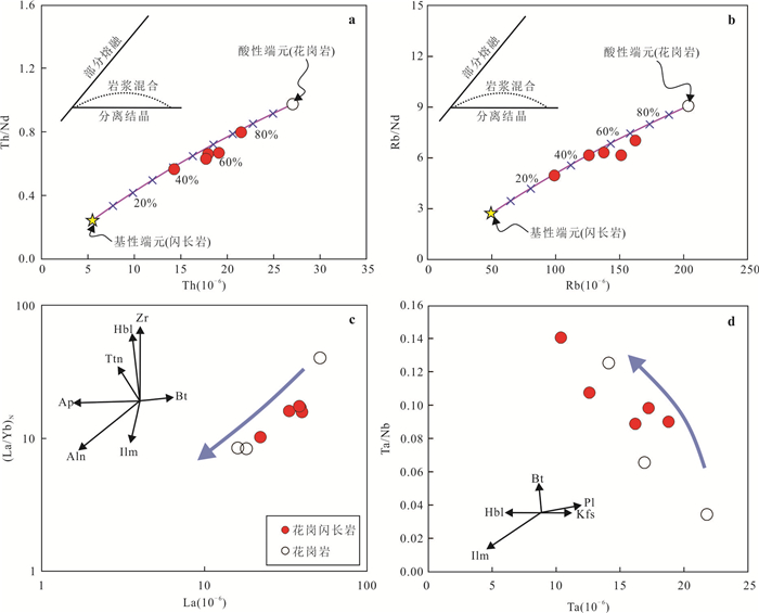
Triassic magmatic rocks in East Kunlun are the key probe to study the Paleo-Tethyan orogeny. This paper presents a detailed petrological, chronological, geochemical and Sr-Nd isotopic study on the Hongshuihe granitoids in the East Kunlun to constrain their petrogenesis and dynamic setting. Zircon U-Pb chronology shows that the crystallization ages of the granodiorite and granites in the Hongshuihe pluton are 243.0 Ma±3.3 Ma and 244.0 Ma±3.1 Ma, respectively. The studied rocks are metaluminous, high-K calc-alkaline Ⅰ-type granitoids, but the granodiorites have lower Na2O/K2O ratios (0.78-0.96) and higher Mg# (42-45) than the granites. All rocks are enriched in large ion lithophile elements but depleted in high field strength elements, and have an enriched Sr-Nd isotopic composition [εNd(t)=-6.53~-4.99, Isr=0.706 871~0.709 126]. Comprehensive studies indicate that the Hongshuihe middle Triassic granitoids were formed in the continental arc environment during the East Kunlun Paleo-Tethyan oceanic crust subduction, and their parental magmas were derived by partial melting of Mesoproterozoic metagreywackes followed by varying degrees of crust-mantle mixing and fractional crystallization. This study also shows that the re-working of ancient continental crust with a certain amount of crust-mantle mixing is the main evolutionary mechanism of Middle Triassic continental crust in the East Kunlun.


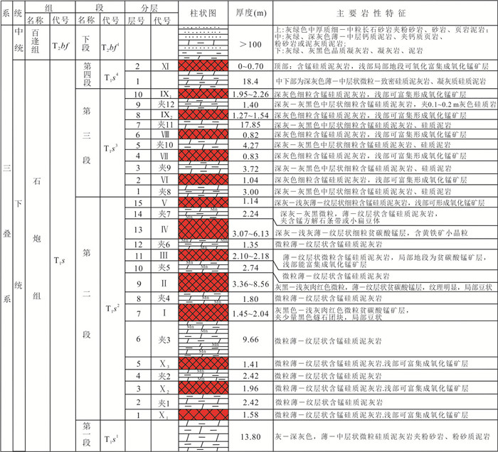
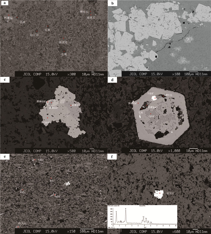
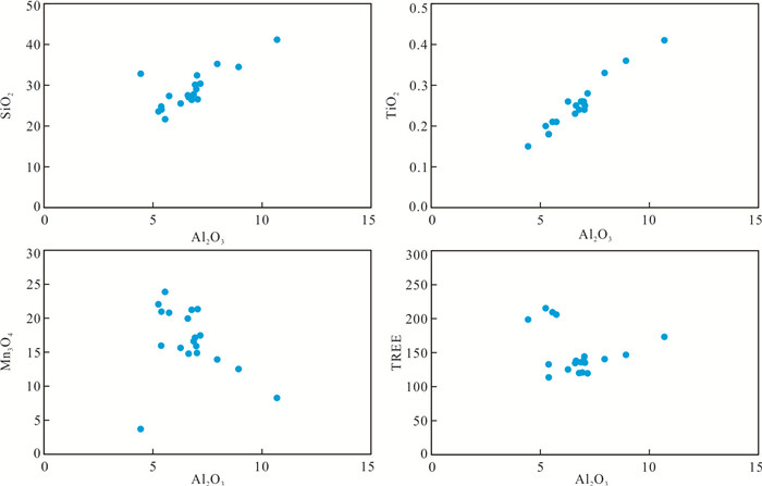
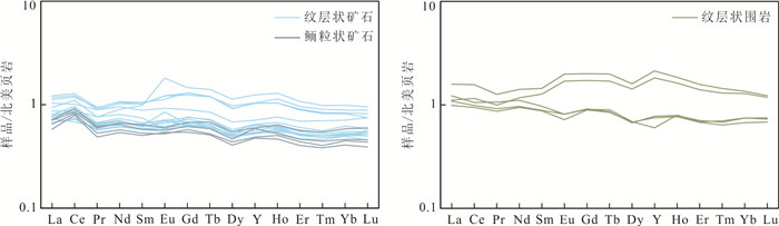
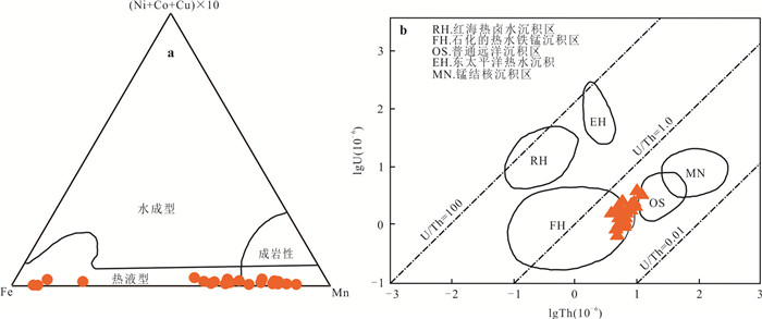
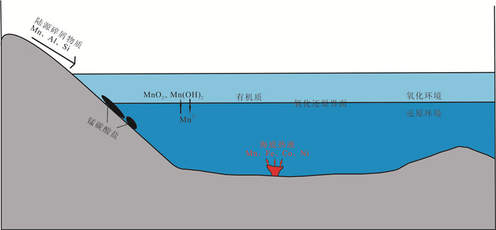
Triassic is one of the most important manganese (Mn) metallogenic epoch, and there are many great to medium sized Mn ore deposits in South China. Dongping manganese deposit is located in the metallogenic belt of southwest Guangxi Zhuang Autonomous Region. In this paper, we discussed sources and genesis of Mn ore deposit by detailed petrographic observations using optical microscope and electron probe micro analysis (EPMA) and geochemical analysis. Based on detailed petrographic observations, we found various metal sulfides, inculding pyrite, chalcopyrite, sphalerite, galena, siegenite, cobalite and other sulfoarsenide in Dongping Mn ore deposit. The Al/(Al+Fe+Mn) and Y/Ho ratio, Fe-Mn-(Ni+Cu+Co)×10 and lgU-lgTh graphs of Mn ores indicated that source of Mn is associated with hydrothermal activity. The positive Ce anomaly and V/(V+Ni) of Mn ores indicate that Mn was initially precipitated in oxic environment. Combining all data, we suggest that source of Mn is associated with hydrothermal activity. Manganese carbonate formed by reduction of Mn oxides derived from hydrothermal activity during the diagenesis.


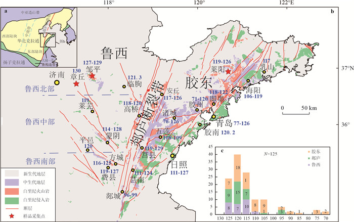
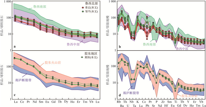
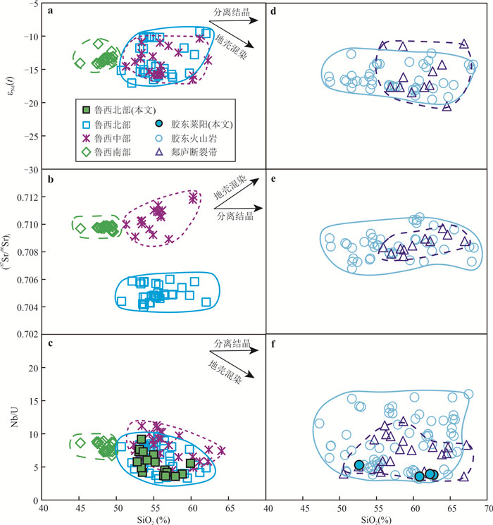
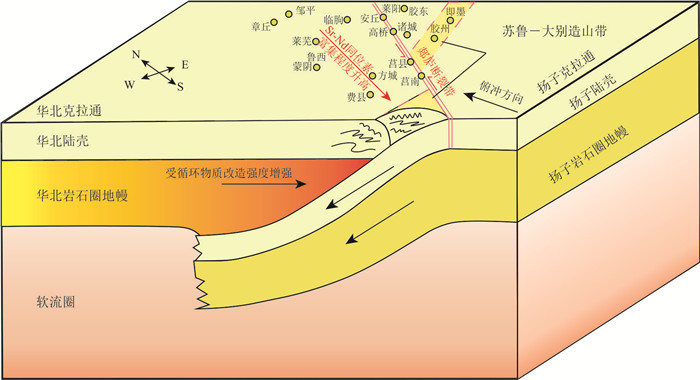
The eastern North China Craton (NCC) experienced strong modification during the Early Cretaceous(130~120 Ma), accompanied by intensive magmatism. Here we compared the geochemical and Sr-Nd isotopic compositions of the Early Cretaceous (130~120 Ma) basaltic andesites to andesites from the Luxi region, the Tan-Lu fault, and the Jiaodong Peninsula in Shandong Province, to investigatethe characteristics of their melting sources, and further discussed the possible cause for the heterogeneity of the source. These rocks with insignificant crustal contamination were generally derived from the lithospheric mantle. They mainly experienced the fractional crystallization of clinopyroxene, apatite, and Ti-Fe oxide during magma differentiation. However, compared to those volcanic rocks in the Tan-Lu fault and the Jiaodong Peninsula, the volcanic rocks from northern Luxi experienced a relatively lower degree of evolution. These volcanic rocks are characterized by arc-like trace element patterns and enriched Sr-Nd isotopes. The Luxi volcanic rocks are characterized by EMⅠ-type mantle source (87Sr/86Sri < 0.706), where as those rocks from the central-southern Luxi, the Tan-Lu fault, and the Jiaodong areas are characterized by EMⅡ-type mantle source (87Sr/86Sri > 0.706), indicating that they were both derived from an enriched lithospheric mantle reservoir which was modified by crustal components. Noticeably, the extent of the enrichment of Sr-Nd isotopes in those volcanic rocks increases gradually from the Northwest to the Southeast. End-member mixing model indicates that the EMⅠ-type mantle source beneath the northern Luxi region was possibly metasomatized by components from the lower crust of the NCC, whereas the EMⅡ-type mantle beneath the central-southern Luxi, the Tan-Lu fault, and the Jiaodong districts was likely metasomatized by materials from the subducted Yangtze continental crust. Fluids from the subducted Paleo-Pacific plate subsequently metasomatized and hydrated the enriched lithospheric mantle of the NCC, leading to the modification in different degrees. Therefore, the Early Cretaceous volcanic rocks in the Shandong Province record significant modification within the lithospheric mantle induced by diverse crustal components. The heterogeneous modification provided critical constraints on the destruction of the lithospheric mantle beneath the eastern NCC.


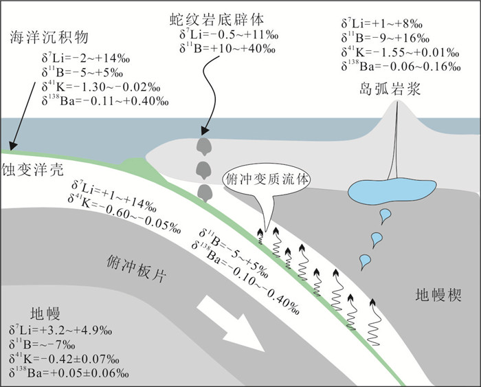
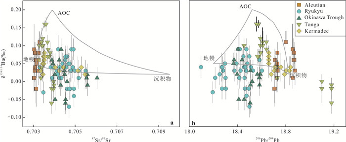
Subduction zones are important sites for recycled material, K, Ba, B and Li, as fluid-mobile elements, are enriched in melts and fluids. At the same time, the isotopic difference of each geochemical reservoir makes it a good tracer for studying various fluid in subduction zone. In recent years, research progresses of Fe isotopetracing the redox state of fluid in subduction zone and K, Ba, Li, B isotope behaviors in the subduction zone are summarized and stable isotopic behavior in a series of geochemical process, including isotopic composition of subducted materials, isotopic fractionation with dehydrated fluid during subduction, interactions between recycled sediments, altered oceanic crust and serpentinite and overlying mantle wedge and elements and stable isotope fractionation in subduction zones. With the improvement in measurement and the improvement of sample data in geochemical reservoir and geochemical sample, stable isotope is helpful to understand the physico chemical processes in subduction zones.


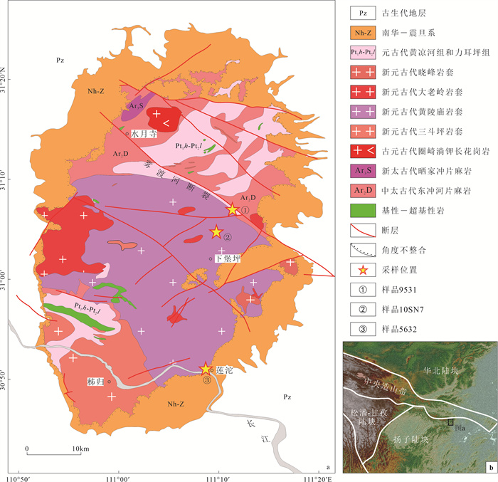
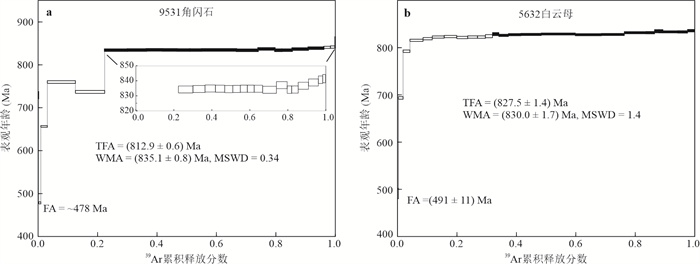
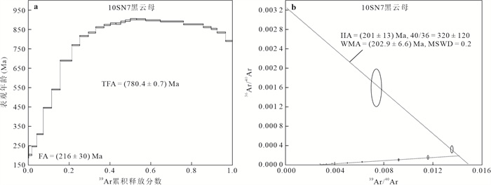
The Huangling uplift, located in the front of the northeast corner of the Sichuan Basin, is composed mainly of Huangling granite. The granite is the geological record of the Jinning orogeny and the Rodinia supercontinent cracking in the Yangtze block, and it is critical for understanding the tectonic evolution and magmatic activity of the Yangtze block. To determine the formation time of the Huangling granite, abundant chronological data were published using isotope chronology methods such as U-Pb, K-Ar, and Rb-Sr. However, as a new chronology technique, 40Ar/39Ar is rarely used in studying Huangling granite. In this study, the age of amphibole in metamorphic rocks and muscovite and biotite in Huanglingmiao granite has been determined by 40Ar/39Ar stage heating technique. The plateau age of amphibole was (835.1±0.8) Ma, and the plateau age of muscovite was (830.0±1.7) Ma. The biotite sample yielded an age spectrum with an upward convex shape, and no obvious flat section was formed. It was concluded that the age of amphibole is much lower than the formation age and metamorphic age of metamorphic rocks, but slightly higher than the muscovite age of nearby granite, indicating the time when the surrounding rock was reset by granite baking and then cooled to 500 ℃. The muscovite age indicates the time Huangling granite cooled to 350 ℃. Both of them restrict the formation time of Huangling granite. Although no plateau age was obtained, the biotite sample gave a meaningful age of 216 Ma in the low-temperature steps, which probably indicates the occurrence time of thermal disturbance in the later stage. The collision and merging of the North China and Yangtze plates caused the slow uplift of the Huangling, and activity of the NNW-trending faults in the Huangling area, and caused the thermal effect enough to affect the Ar closure of the biotite. The high precision 40Ar/39Ar age provides accurate chronological support for determining the tectonic evolution history of Huangling granite.


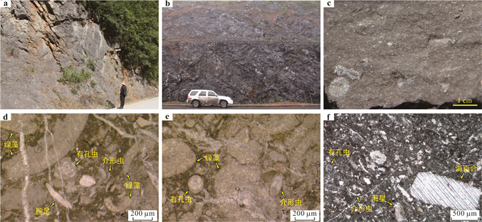
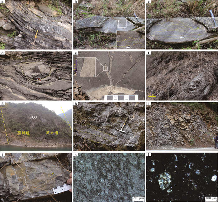
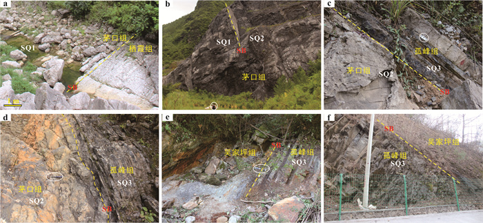
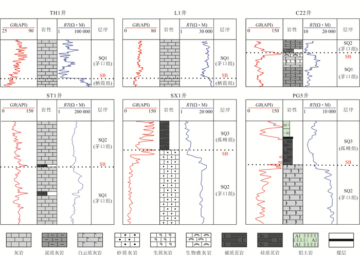
In the last two years, significant breakthroughs have been achieved in the shale gas exploration within the Upper Permian Wuchiaping Formation to Talung Formation in the northern Sichuan and western Hubei provicnes, South China. Furthermore, a promising exploration perspective has also emerged in the Middle Permian Kuhfeng Formation. However, the distribution patterns of the organic-rich strata and the potential shale gas resources in these formations are not yet fully understood. By identifying sedimentary facies and correlating sequence stratigraphy in the Middle Permian of northern Sichuan and western Hubei area, the characteristics of lithofacies paleogeography in different sequences and their evolution were analyzed. Following this, it explores the distribution patterns of organic-rich layers and the shale gas resource potential in the Kuhfeng Formation. The research reveals that three third-order sequences, namely SQ1, SQ2, and SQ3, are identified from the Middle Permian formations in the northern Sichuan and western Hubei area. Specifically, sequence SQ3 corresponds to the Kuhfeng Formation and was deposited during the late Capitanian. During the deposition of sequence SQ3, three northwest-trending deep-water basins developed on a carbonate platform (corresponding to sequences SQ1 and SQ2). These basins are the western Hubei Basin, the Kaijiang-Liangping Platform Basin (trough), and the Guang-Wang Platform Basin (trough), respectively.The Kuhfeng Formation exhibits a relatively continuous and stable distribution of organic-rich layers, mainly including bedded chert and siliceous shale layers with high organic carbon content (average TOC content ranging from 3.0% to 10%). The Emeishan mantle plume contributed to the formation of the deep-water slope-basin environment during the late Middle Permian in this area, further controlling the large-scale regional deposition of organic-rich bedded cherts and siliceous shales within the Kuhfeng Formation. Based on these above results and further comprehensive analyses of geological evaluation factors of shale gas, such as the effective thickness of bedded chert and siliceous shale, TOC content, and tectonic preservation conditions, five favorable areas for shale gas reservoirs covering approximately 12, 000 km2 are identified in the northeastern Sichuan to the western Hunan-Hubei region. The estimated total shale gas resource is approximately 1.75 trillion cubic meters, demonstrating significant potential of shale gas exploration and development in the region.


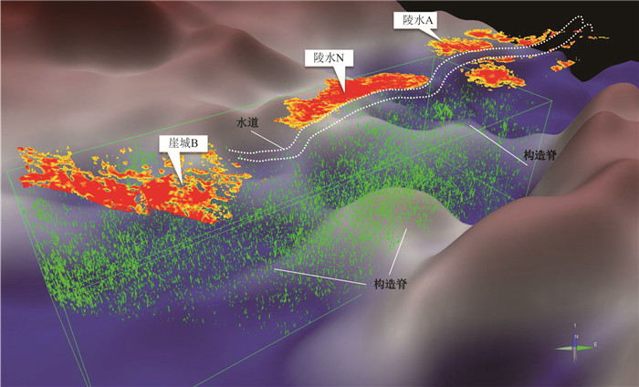
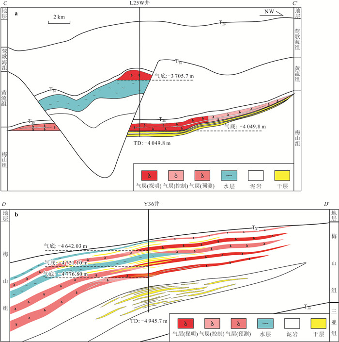
To study the key problems restricting exploration are the traps effectiveness and gas enrichment rule. Based on the analysis of submarine fan reservoir characteristics, trap formation and lateral sealing conditions, natural gas migration and accumulation, the main controlling factors of deep-water submarine fan traps large-scale accumulation is researched. The results show that: (1)The submarine fan coming from Hainan uplift is mainly distributed in the northern slope area, and the submarine fan in the depression zone coming from the western Kunsong uplift develop large-scale advancing far into the sag, and the physical properties of the reservoir become better. (2)The types of trap lateral sealing mechanisms are establishing, including sealed by mudstone channel type, sealed by sandstone channel type, lithological pinch-out type and fault lateral sealing type. (3)The mature to high mature natural gas of Meishan submarine fan were supplied by source rock of Yacheng formation, Accumulation mode was large-scale structural ridge convergence in source rock, vertical and lateral migration system with fault or fracture and sandstone, and effective traps cotrolling accumulation. It has been made breakthroughs in lithological pinch-out type and sealed by mudstone channel type, and the next expansion direction is explicited.


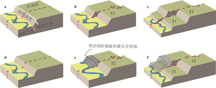
The fault slip rate of is critical for understanding strain partitioning within a fault system and assessing seismic hazard. Tectonic geomorphology method can be used in constraining Quaternary slip rates in general. In the active fault system of Tibetan Plateau, the Haiyuan Fault Zone accommodates part of Indo-Asian convergence and its slip rate provides reference for understanding the mechanics of continental deformation. Thus, several slip rate studies have been carried out along the Haiyuan fault during the past 3 decades and the results range from 2.3 mm/a to 16 mm/a, which caused controversy and confusion. Based on a review of the previous studies, we point out that the main reason for the difference in previous studies is the choice of upper terrace and lower terrace reconstruction models. We infer that the upper and lower bound of slip rates are obtained based on the two models in general, which cannot be simply equated with the real slip rate value. When there is a lack of observational data to distinguish the reliability of the two models, a combination of upper and lower terrace abandonment age constraints can be used to bracket the slip rate. The method shows the respect and recognition of the objective uncertainty in the calculation process of slip rate. In addition, the evaluation of slip rates of Haiyuan fault zone can provide a basis for the identification of two end models of the Tibetan Plateau based on the intro-block faults deformation.


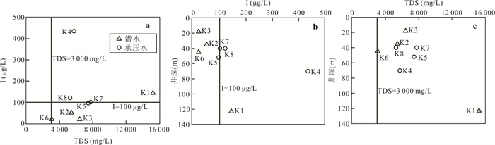
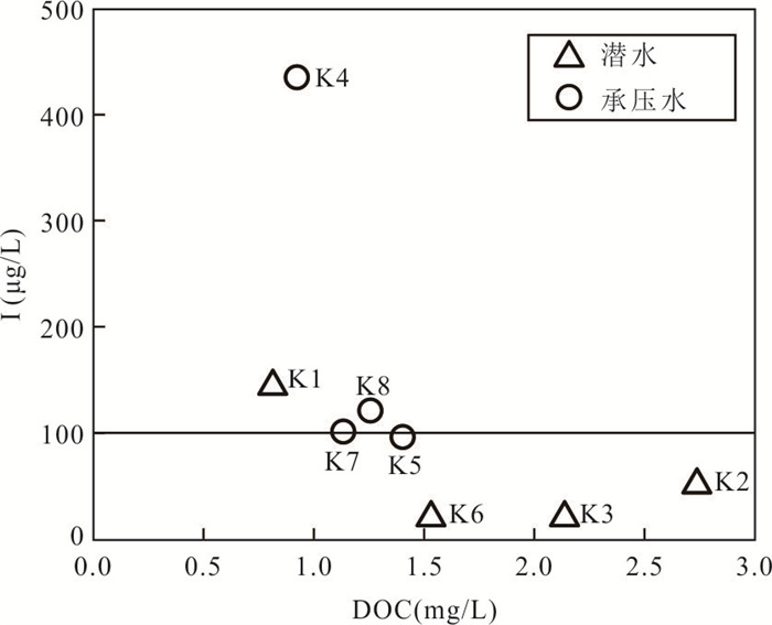
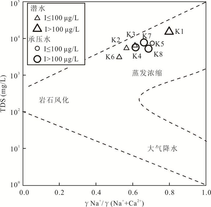
Kashgar River in Xinjiang is located in a typical arid and semi-arid area. The abnormal contents of total dissolved solids (TDS) and iodine in groundwater in the lower reaches of the river seriously threaten the local water security. Taking the plain area in the lower reaches of Kashigar River as the study area, the distribution of iodine in saline groundwater and its influence on iodine enrichment were determined through analysis of the hydrochemical characteristics, Cl/Br mole ratio, stable isotopes of hydrogen and oxygen, occurrence environment of groundwater and hydrogeochemical process. The results showed that the iodine content of groundwater in the study area varies from < 0.40 μg/L to 435.00 μg/L (mean 123.50 μg/L). The mean iodine content of unconfined groundwater and confined groundwater is 58.75 μg/L and 188.25 μg/L, respectively, and the proportion of high iodine groundwater is 25.0% and 75.0%, respectively. The main hydrochemical types are Cl·SO4 and SO4·Cl. TDS of groundwater ranged from 3 079.13 mg/L to 15 249.50 mg/L, mainly in neutral to slightly alkaline saline groundwater (87.5%), followed by saline groundwater (12.5%). The main form of iodine is I- (87.5%), followed by IO3-(12.5%), and there is no coexistence form. The existence of iodine in IO3- and I- forms in the suboxidizing environment and the subreducing environment is favorable, respectively. High TDS, fine lithology, gentle topography, shallow burial conditions of groundwater and alkaline environment are all conducive to the accumulation of iodine in groundwater. The iodine enrichment in unconfined groundwater is mainly affected by evaporation concentration and the dissolution of evaporite, while the iodine enrichment in confined groundwater is mainly affected by the dissolution of iron-bearing minerals under reduction conditions and alluvial-lacustrine sediments. The Cl- to Cl/Br mole ratio indicates that the high iodine water in unconfined groundwater is obviously affected by evaporation.


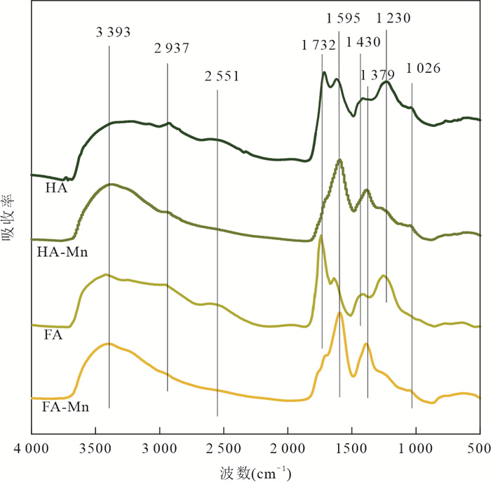
Mn(Ⅲ) is the intermediate electron transport of manganese cycling, widely involved in the terrestrial and marine ecosystems in the geochemical cycle of carbon, iron and sulfur. Recently, Mn(Ⅲ)-humic ligands colloids are found in oxide, suboxic and anoxic zone.It is of great significance to study the formation mechanism and behavior characteristics of Mn(Ⅲ)-humic colloid in groundwater environment for understanding the geochemical cycle of manganese and the migration and transformation mechanism of nutrients and pollutants affected by it. In this study, batch experiments were conducted to explore the effects of oxygen conditions, humus concentration and organic matter species on the formation of Mn(Ⅲ)-humic ligands colloids andcombined with FTIR, XRD, XPS, TEM and other means to characterize the physicochemical properties and stability. Resultsshow that suboxic and anoxic environments favor Mn(Ⅲ)-humiccolloid formation. The degree of complexation of Mn(Ⅲ)-humic colloid increases with the increase of humic ligands concentration. FA is more easily complexed with Mn(Ⅲ), but the colloidal stability is worse than that of Mn(Ⅲ)-HA colloid.Furthermore, Mn(Ⅲ)-humic colloid is in an amorphous form, and oxygen-containing functional groups such as carboxyl groups on humus form an internal sphere complex with Mn(Ⅲ), which can stabilize Mn(Ⅲ) and slow down the degree of disproportionation.Mn(Ⅲ)-humic colloid has oxidation and adsorption capacity, which has important environmental significance for the migration and transformation of pollutants in groundwater.