2024 Vol. 49, No. 3
Display Method:
2024, 49(3): 803-821.
doi: 10.3799/dqkx.2022.096
 PDF 6749KB
Abstract:
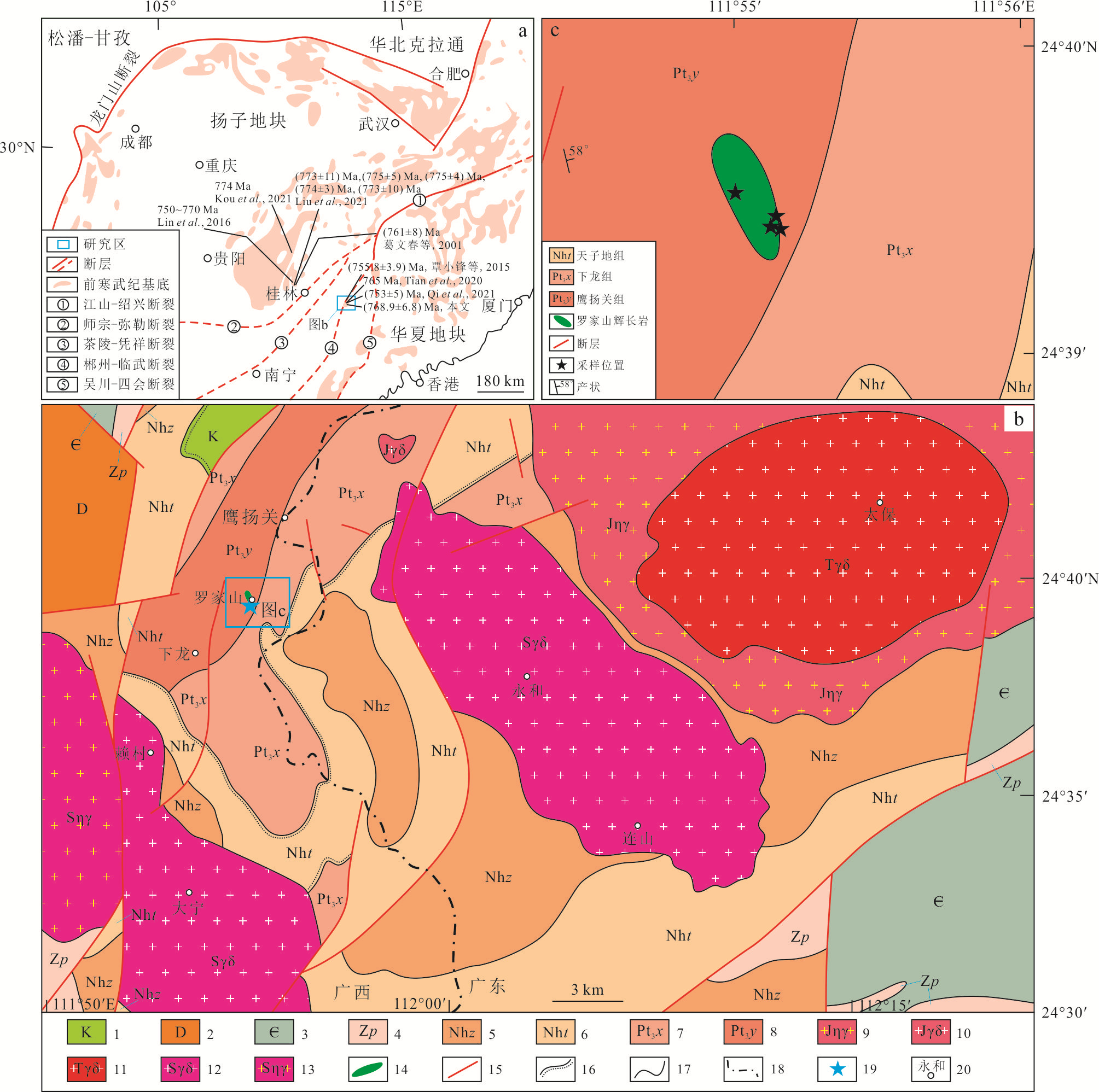
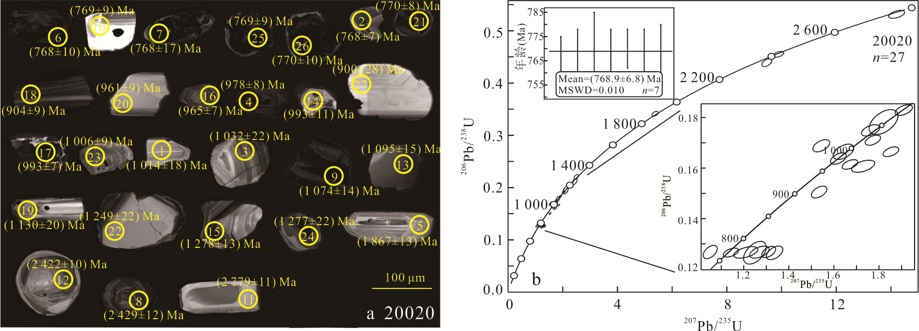
In this paper, the geochronology, mineralogy and mineral chemistry of Luojiashan gabbro in Yingyangguan area of northeastern Guangxi were studied, to constrain the regional tectonic background. The main mineral compositions of Luojiashan gabbro are clinopyroxene (Cpx) and plagioclase (Pl). The clinopyroxene of Luojiashan gabbro is characterized by high Fe, Al, and low Ca, Na, Ti, and its composition is Wo27-31En36-47Fs21-32, which belongs to augite. Plagioclase is characterized by high Si, Al, Na, and low Ca, K, and its composition is An0-3Ab96-100Or0-2, which belongs to albite. According to the chemical composition of clinopyroxene, the parental magma of the Luojiashan gabbro should belong to tholeiitic series. The crystallization temperature and pressure of clinopyroxene were estimated by the clinopyroxene-melt equilibrium and clinopyroxene isotherm, which yielded crystallization temperature of 1 282-1 292 ℃, with an average of 1 287 ℃. The pressures are 1.53-2.37 GPa, with an average of 2.02 GPa, and corresponding to a formation depth of 50.49-78.21 km, with an average of 66.80 km. The Luojiashan gabbro was formed at (768.9±6.8) Ma based on LA-ICP-MS zircon U-Pb dating. The chemical composition of clinopyroxene indicates that Luojiashan gabbro is a typical intraplate tholeiite. Combined with the characteristics of regional tectonic evolution, it is inferred that the Luojiashan gabbro in northeastern Guangxi originated from the extensional rift tectonic background of lithosphere thinning and mantle upwelling.
In this paper, the geochronology, mineralogy and mineral chemistry of Luojiashan gabbro in Yingyangguan area of northeastern Guangxi were studied, to constrain the regional tectonic background. The main mineral compositions of Luojiashan gabbro are clinopyroxene (Cpx) and plagioclase (Pl). The clinopyroxene of Luojiashan gabbro is characterized by high Fe, Al, and low Ca, Na, Ti, and its composition is Wo27-31En36-47Fs21-32, which belongs to augite. Plagioclase is characterized by high Si, Al, Na, and low Ca, K, and its composition is An0-3Ab96-100Or0-2, which belongs to albite. According to the chemical composition of clinopyroxene, the parental magma of the Luojiashan gabbro should belong to tholeiitic series. The crystallization temperature and pressure of clinopyroxene were estimated by the clinopyroxene-melt equilibrium and clinopyroxene isotherm, which yielded crystallization temperature of 1 282-1 292 ℃, with an average of 1 287 ℃. The pressures are 1.53-2.37 GPa, with an average of 2.02 GPa, and corresponding to a formation depth of 50.49-78.21 km, with an average of 66.80 km. The Luojiashan gabbro was formed at (768.9±6.8) Ma based on LA-ICP-MS zircon U-Pb dating. The chemical composition of clinopyroxene indicates that Luojiashan gabbro is a typical intraplate tholeiite. Combined with the characteristics of regional tectonic evolution, it is inferred that the Luojiashan gabbro in northeastern Guangxi originated from the extensional rift tectonic background of lithosphere thinning and mantle upwelling.


2024, 49(3): 822-836.
doi: 10.3799/dqkx.2022.196
Abstract:
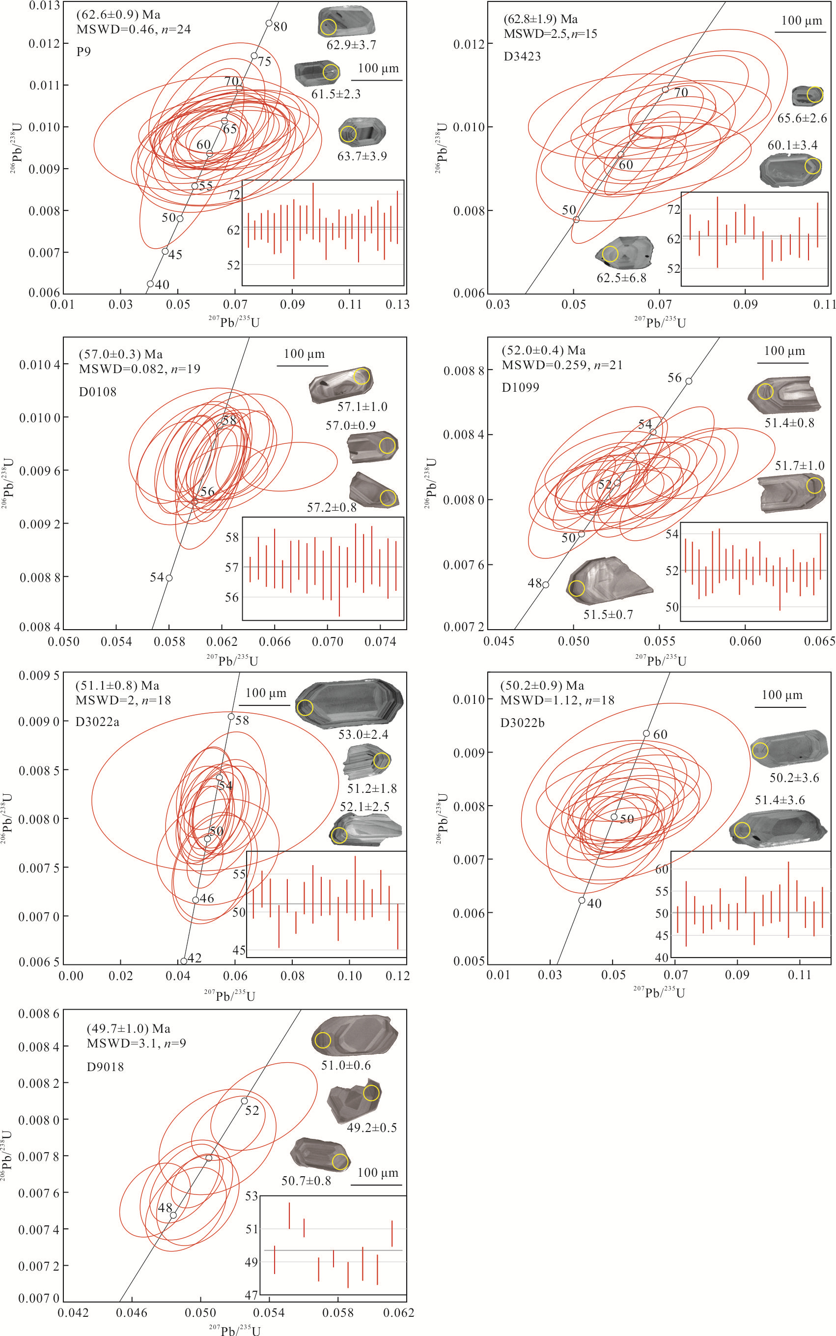
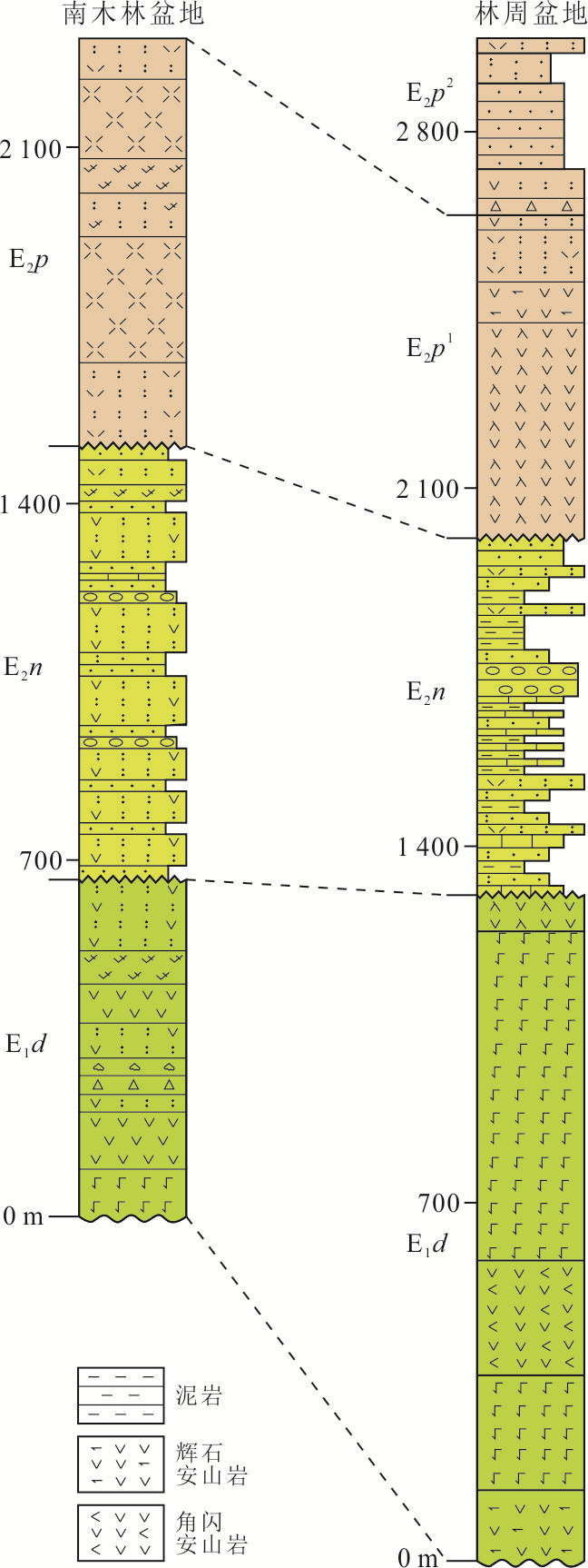
In order to better constrain the age framework, petrogenesis and evolution history of the Linzizong volcanic succession (LVS), this study focuses on the petrography, zircon U-Pb geochronology and whole-rock geochemical characteristics analyses of LVS in Namling basin in the central-southern Lhasa Terrane. Results show that the periods of eruptive cycles of LVS in Namling basin are 62.8 Ma to 57.0 Ma, 52.0 Ma to 50.2 Ma and 49.7 Ma, respectively. With the evolution of time, the lithofacies have changed. Dianzhong Formation is dominated by the eruption facies, Nianbo Formation is dominated by the eruption-sedimentary facies, while Pana Formation is dominated by the eruption-overflow facies. Meanwhile, it shows the trend of evolution from andesitic to acidic, from calc-alkaline to high K calc-alkaline to shoshonite series. The dacite rocks of Dianzhong Formation are calc-alkaline series, which are enriched in LILE, depleted of HFSE, with obvious negative anomalies of Nb, Ta and Ti, showing typical arc volcanic characteristics. The rhyolite rocks of Nianbo Formation and Pana Formation are calc-alkaline to high K calc-alkaline series with occurrence of shoshonite series, which are enriched in LILE, and depleted in HFSE. In addition to the obvious negative anomalies of Nb, Ta and Ti, there are also significant negative anomalies of Ba, Sr and P, showing the characteristics of collision to post-collision volcanic rocks. The above features suggest that the dacite rocks of Dianzhong Formation may be the product of partial melting of the overlying crust induced by the undercutting of mantle-derived magma in the arc region during the northward subduction of the Neo-Tethys Ocean. While, the rhyolite rocks of Nianbo Formation and Pana Formation are the products of further separation and crystallization of dacite rocks in the early stage of the Indian-Asian continental collision. In summary, LVS is an important archive for recording this system transformation from subduction to collision.
In order to better constrain the age framework, petrogenesis and evolution history of the Linzizong volcanic succession (LVS), this study focuses on the petrography, zircon U-Pb geochronology and whole-rock geochemical characteristics analyses of LVS in Namling basin in the central-southern Lhasa Terrane. Results show that the periods of eruptive cycles of LVS in Namling basin are 62.8 Ma to 57.0 Ma, 52.0 Ma to 50.2 Ma and 49.7 Ma, respectively. With the evolution of time, the lithofacies have changed. Dianzhong Formation is dominated by the eruption facies, Nianbo Formation is dominated by the eruption-sedimentary facies, while Pana Formation is dominated by the eruption-overflow facies. Meanwhile, it shows the trend of evolution from andesitic to acidic, from calc-alkaline to high K calc-alkaline to shoshonite series. The dacite rocks of Dianzhong Formation are calc-alkaline series, which are enriched in LILE, depleted of HFSE, with obvious negative anomalies of Nb, Ta and Ti, showing typical arc volcanic characteristics. The rhyolite rocks of Nianbo Formation and Pana Formation are calc-alkaline to high K calc-alkaline series with occurrence of shoshonite series, which are enriched in LILE, and depleted in HFSE. In addition to the obvious negative anomalies of Nb, Ta and Ti, there are also significant negative anomalies of Ba, Sr and P, showing the characteristics of collision to post-collision volcanic rocks. The above features suggest that the dacite rocks of Dianzhong Formation may be the product of partial melting of the overlying crust induced by the undercutting of mantle-derived magma in the arc region during the northward subduction of the Neo-Tethys Ocean. While, the rhyolite rocks of Nianbo Formation and Pana Formation are the products of further separation and crystallization of dacite rocks in the early stage of the Indian-Asian continental collision. In summary, LVS is an important archive for recording this system transformation from subduction to collision.


2024, 49(3): 837-849.
doi: 10.3799/dqkx.2022.474
Abstract:
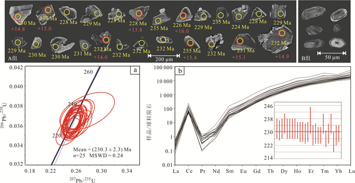
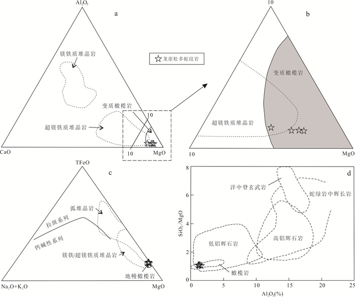
Zircons in serpentinite can not only provide chronological information, but also constrain the genesis of serpentinite and regional tectonic evolution process. Longyasongduo serpentinite in Tangjia-Sumdo Paleo-Tethys suture zone was studied by means of zircon U-Pb dating, whole-rock geochemistry, and zircon Hf isotope in this paper. The results show that Longyasongduo serpentinites have high MgO, TFeO and Mg# values but low Al2O3 and TiO2 contents. The chondrite-normalized REE patterns display a gentle U-type. The primitive mantle-normalized spider diagrams exhibit enrichment in U, Ta and depletion in Th, Nb, Zr and Hf. Zircon U-Pb dating of Longyasongduo serpentinite yielded ages of (230.3±2.3) Ma, with εHf(t) values of +13.4 to +16.0. Through chronological and geochemical studies, we argue that the protolith of Longyasongduo serpentinite is the residual of partially melted spinel lherzolite in the mantle wedge. Longyasongduo serpentinite was metasomatized by supercritical fluid generated by subduction of Sumdo Paleo-Tethys oceanic crust to form metasomatic zircon, which may also be metasomatized by aqueous solutions, resulting in enrichment of fluid-mobile elements. Based on previous studies, we infer that the Sumdo Paleo-Tethys Ocean was still in a northward subduction setting in the Late Triassic.
Zircons in serpentinite can not only provide chronological information, but also constrain the genesis of serpentinite and regional tectonic evolution process. Longyasongduo serpentinite in Tangjia-Sumdo Paleo-Tethys suture zone was studied by means of zircon U-Pb dating, whole-rock geochemistry, and zircon Hf isotope in this paper. The results show that Longyasongduo serpentinites have high MgO, TFeO and Mg# values but low Al2O3 and TiO2 contents. The chondrite-normalized REE patterns display a gentle U-type. The primitive mantle-normalized spider diagrams exhibit enrichment in U, Ta and depletion in Th, Nb, Zr and Hf. Zircon U-Pb dating of Longyasongduo serpentinite yielded ages of (230.3±2.3) Ma, with εHf(t) values of +13.4 to +16.0. Through chronological and geochemical studies, we argue that the protolith of Longyasongduo serpentinite is the residual of partially melted spinel lherzolite in the mantle wedge. Longyasongduo serpentinite was metasomatized by supercritical fluid generated by subduction of Sumdo Paleo-Tethys oceanic crust to form metasomatic zircon, which may also be metasomatized by aqueous solutions, resulting in enrichment of fluid-mobile elements. Based on previous studies, we infer that the Sumdo Paleo-Tethys Ocean was still in a northward subduction setting in the Late Triassic.


2024, 49(3): 850-867.
doi: 10.3799/dqkx.2023.135
Abstract:
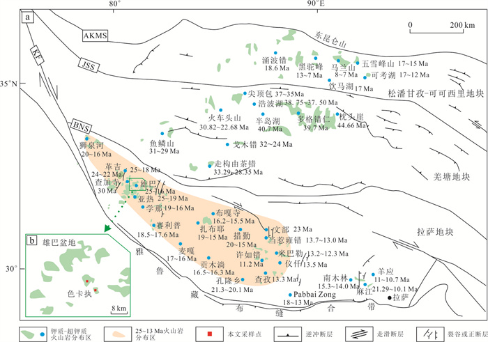
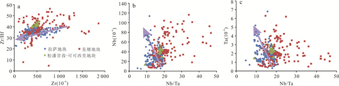
Post-collisional potassic-ultrapotassic volcanic rocks are widely developed in the Lhasa block, Qiangtang block and Songpan-Ganzi-Kekexili block in the Qinghai-Xizang region. Many previous studies on the potassic-ultrapotassic volcanic rocks in this area show the supernormal enrichment of trace alkali elements such as Rb and Cs in the Lhasa block is much higher than those in other two blocks. In order to quantify this phenomenon and to investigate the causes of enrichment, this paper quantifies the enrichment degree of trace alkali elements in the three blocks, and has attained a preliminary understanding of the causes of enrichment, based on the measured and published data, using statistical methods such as box-plot and systematic mineralogical and geochemical analysis methods, It is concluded that the high degree of magmatic differentiation in the potassic-ultrapotassic volcanic rocks of the Lhasa block is the main cause of the rare alkali elements enrichment of Rb and Cs, and the enrichment zones are mainly located in the central and western part of the Lhasa block, where the volcanic rocks range in age from 25 to 13 Ma. The discrimination range of Zr/Hf and Nb/Ta with high degree of differentiation of potassic-ultrapotassic volcanic rocks in the Lhasa block is also delineated by analogy with the results of highly differentiated granites.
Post-collisional potassic-ultrapotassic volcanic rocks are widely developed in the Lhasa block, Qiangtang block and Songpan-Ganzi-Kekexili block in the Qinghai-Xizang region. Many previous studies on the potassic-ultrapotassic volcanic rocks in this area show the supernormal enrichment of trace alkali elements such as Rb and Cs in the Lhasa block is much higher than those in other two blocks. In order to quantify this phenomenon and to investigate the causes of enrichment, this paper quantifies the enrichment degree of trace alkali elements in the three blocks, and has attained a preliminary understanding of the causes of enrichment, based on the measured and published data, using statistical methods such as box-plot and systematic mineralogical and geochemical analysis methods, It is concluded that the high degree of magmatic differentiation in the potassic-ultrapotassic volcanic rocks of the Lhasa block is the main cause of the rare alkali elements enrichment of Rb and Cs, and the enrichment zones are mainly located in the central and western part of the Lhasa block, where the volcanic rocks range in age from 25 to 13 Ma. The discrimination range of Zr/Hf and Nb/Ta with high degree of differentiation of potassic-ultrapotassic volcanic rocks in the Lhasa block is also delineated by analogy with the results of highly differentiated granites.


2024, 49(3): 868-892.
doi: 10.3799/dqkx.2022.214
Abstract:
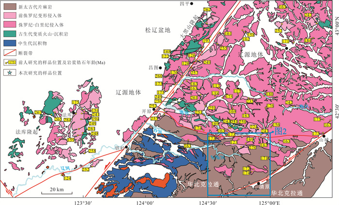
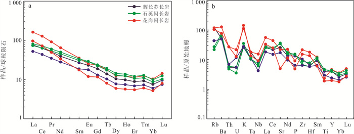
Qingyuan area in northern Liaoning, located at the eastern segment of the northern margin of the North China Craton, is one of the typical areas to study the paleo-Pacific ocean tectonic domain. The petrogenesis and tectonic setting of Mesozoic magmatic rocks in the study area are of great significance for understanding the evolution of the paleo-Pacific tectonic domain. This study focuses on the zircon U-Pb geochronology and geochemistry of gabbronorite, quartz diorite and granodiorite in the Xiajiapu area of Qingyuan. Zircon U-Pb dating results show that gabbronorite, quartz diorite and granodiorite were emplaced in the (163.8±2.4) Ma, (169.9±2.2) Ma and 169.9-167.3 Ma respectively. Geochemical characteristics of Gabbronorite and quartz diorite show that they have low SiO2 content, high Al2O3 content and high Mg# value, which are typical of the calc-alkaline series. Samples are weakly enriched in LREEs and enriched in LILEs (e.g., Rb, Ba, K, Sr) and depleted in HFSEs (e.g., Nb, Ta, ), and Eu shows weak positive or no anomaly; Granodiorite shows a high content of SiO2, Al2O3 and total-alkali, which is typical of the high-K calc-alkaline Ⅰ-type granite. Samples have high Sr/Yb values and weak Eu negative anomalies, and they are enriched in LREEs and LILEs (e.g., Rb, K and Ba) and depleted in HREEs and HFSEs (e.g., Nb, Ta). Based on these data, we conclude that primary magma of gabbronorite and quartz diorite is likely derived from partial melting of lithospheric mantle, which is metasomatized by fluid from subducted oceanic slab. Granodiorite is derived mainly from partial melting of mafic rocks in lower crust, which is metasomatized by fluid. Combining with regional tectonic evolution and spatial distribution of magmatic activity, we suggest that the origin of Middle Jurassic intrusive rocks in Xiajiapu area, Qingyuan, northern Liaoning might be related to the subduction of paleo-Pacific plate.
Qingyuan area in northern Liaoning, located at the eastern segment of the northern margin of the North China Craton, is one of the typical areas to study the paleo-Pacific ocean tectonic domain. The petrogenesis and tectonic setting of Mesozoic magmatic rocks in the study area are of great significance for understanding the evolution of the paleo-Pacific tectonic domain. This study focuses on the zircon U-Pb geochronology and geochemistry of gabbronorite, quartz diorite and granodiorite in the Xiajiapu area of Qingyuan. Zircon U-Pb dating results show that gabbronorite, quartz diorite and granodiorite were emplaced in the (163.8±2.4) Ma, (169.9±2.2) Ma and 169.9-167.3 Ma respectively. Geochemical characteristics of Gabbronorite and quartz diorite show that they have low SiO2 content, high Al2O3 content and high Mg# value, which are typical of the calc-alkaline series. Samples are weakly enriched in LREEs and enriched in LILEs (e.g., Rb, Ba, K, Sr) and depleted in HFSEs (e.g., Nb, Ta, ), and Eu shows weak positive or no anomaly; Granodiorite shows a high content of SiO2, Al2O3 and total-alkali, which is typical of the high-K calc-alkaline Ⅰ-type granite. Samples have high Sr/Yb values and weak Eu negative anomalies, and they are enriched in LREEs and LILEs (e.g., Rb, K and Ba) and depleted in HREEs and HFSEs (e.g., Nb, Ta). Based on these data, we conclude that primary magma of gabbronorite and quartz diorite is likely derived from partial melting of lithospheric mantle, which is metasomatized by fluid from subducted oceanic slab. Granodiorite is derived mainly from partial melting of mafic rocks in lower crust, which is metasomatized by fluid. Combining with regional tectonic evolution and spatial distribution of magmatic activity, we suggest that the origin of Middle Jurassic intrusive rocks in Xiajiapu area, Qingyuan, northern Liaoning might be related to the subduction of paleo-Pacific plate.


2024, 49(3): 893-906.
doi: 10.3799/dqkx.2022.231
Abstract:
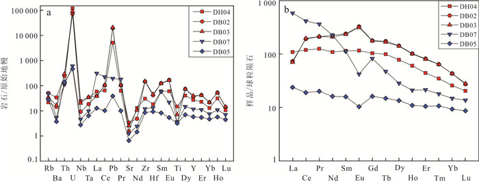
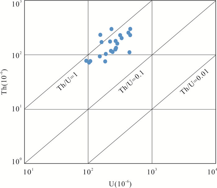
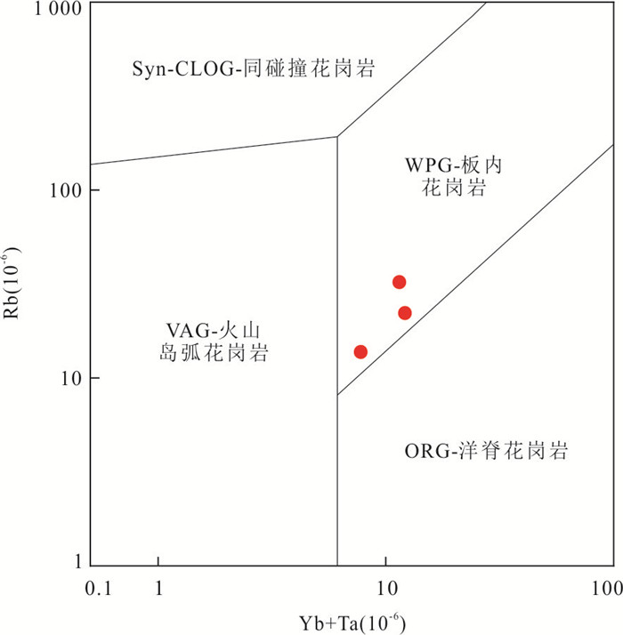
Located in the middle and southern part of the Kangdian axis, Bajiaojing area in Huili, Sichuan Province is a rare Proterozoic uranium mining area in China. However, the relevant study is insufficient due to its complex structural conditions, and hardly any research has been reported on albite, an important uranium bearing rock in this area, which seriously restricts further uranium exploration. On the basis of previous studies, through the field geological survey of 1841 uranium mineralization points in Bajiaojing area, the geochemical analysis of rock elements of albite and the test analysis of zircon U-Pb chronology, it is found that albite in the study area is divided into magmatic albite and metasomatic albite. The samples are enriched in Th, U, Zr and REE, and relatively depleted in Ba, K, Sr and Rb. The dating results show that the two main peak ages are ~2.3 Ga and ~1.8 Ga. The albite is mainly derived from the partial melting of metamorphic mudstone in the lower crust and the addition of mantle derived materials, which was formed in the tectonic environment of intracontinental rift. The formation of its protolith is related to the collision event in the southwest margin of the Yangtze platform during 2.4-2.3 Ga, and underwent magmatism at about 1.8 Ga to form albite, and U element is enriched here. The two magmatic activities recorded by its chronological data are the response of the convergence of Columbia supercontinent in the southwest margin of the Yangtze block.
Located in the middle and southern part of the Kangdian axis, Bajiaojing area in Huili, Sichuan Province is a rare Proterozoic uranium mining area in China. However, the relevant study is insufficient due to its complex structural conditions, and hardly any research has been reported on albite, an important uranium bearing rock in this area, which seriously restricts further uranium exploration. On the basis of previous studies, through the field geological survey of 1841 uranium mineralization points in Bajiaojing area, the geochemical analysis of rock elements of albite and the test analysis of zircon U-Pb chronology, it is found that albite in the study area is divided into magmatic albite and metasomatic albite. The samples are enriched in Th, U, Zr and REE, and relatively depleted in Ba, K, Sr and Rb. The dating results show that the two main peak ages are ~2.3 Ga and ~1.8 Ga. The albite is mainly derived from the partial melting of metamorphic mudstone in the lower crust and the addition of mantle derived materials, which was formed in the tectonic environment of intracontinental rift. The formation of its protolith is related to the collision event in the southwest margin of the Yangtze platform during 2.4-2.3 Ga, and underwent magmatism at about 1.8 Ga to form albite, and U element is enriched here. The two magmatic activities recorded by its chronological data are the response of the convergence of Columbia supercontinent in the southwest margin of the Yangtze block.


2024, 49(3): 907-921.
doi: 10.3799/dqkx.2021.256
Abstract:
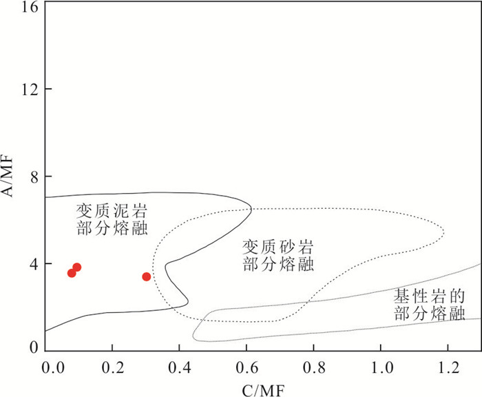
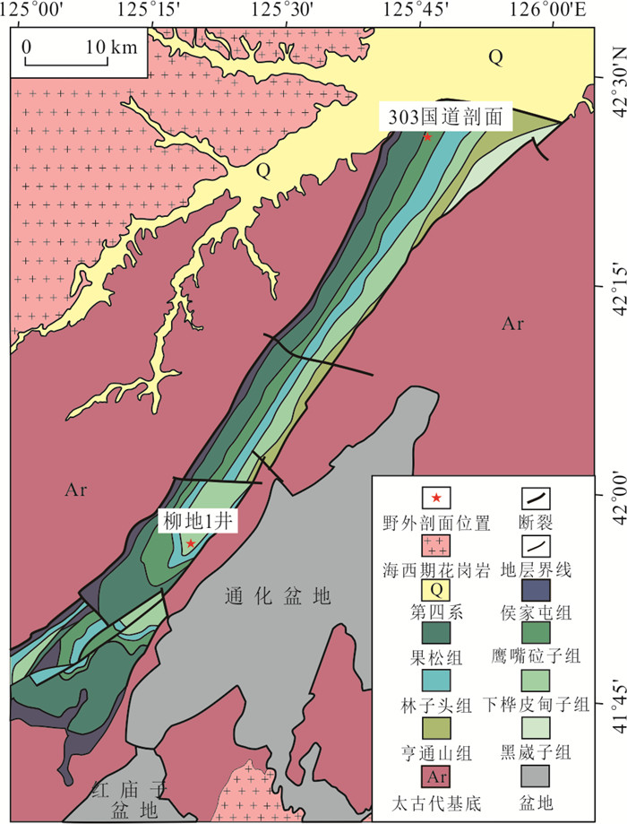
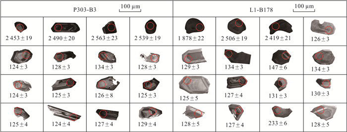
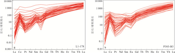
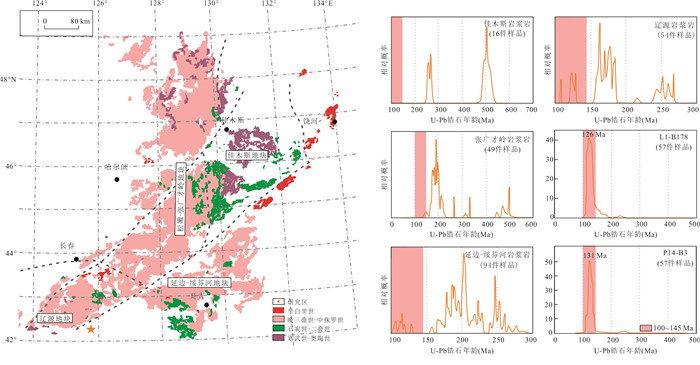
The Late Mesozoic westward subduction of the Paleo-Pacific Plate impacted the northern border of the North China Plate, causing significant tectonic deformation and large-scale magmatic activity. The Liuhe basin is situated on the North China Plate's northern border. The study of the Liuhe basin can be used to constrain the Late Mesozoic tectonic development of the North China Plate's northern border. The mineral composition of the basin samples is characterized by low quartz content and high rock debris and feldspar content, indicating that the sediment provenance primarily comes from the magmatic arc provenance area, according to mineral composition characteristics, sedimentary facies evolution, and detrital zircon U-Pb chronological characteristics of the basin samples. The age composition of detrital zircons from the two groups of samples from the Early Cretaceous Yingzuilazi Formation in the research area is similar, mainly in Late Mesozoic, supplemented by Paleoproterozoic. The major peak of the detrital zircons in L1-B178 samples is around 127 Ma, and the secondary peak is around 2 553 Ma. The Mesozoic sediment provenance may come from the igneous rocks of the basin, as the P303-B3 sample contains a major peak of around 126 Ma and a secondary peak of about 2 545 Ma. The maximum sedimentary age of the strata is (125±4) Ma, which is between the Early Cretaceous Barremian and Aptian stages and is compatible with the weighted average zircon age of (124.3±0.7) Ma for the rhyolite samples. The Liuhe basin, located on the northern boundary of the North China Plate, obtained its provenance from the ancient Pacific Plate subduction about (125±4) Ma, according to mineral composition features, sedimentary facies history, and detrital zircon U-Pb dating characteristics of basin samples.
The Late Mesozoic westward subduction of the Paleo-Pacific Plate impacted the northern border of the North China Plate, causing significant tectonic deformation and large-scale magmatic activity. The Liuhe basin is situated on the North China Plate's northern border. The study of the Liuhe basin can be used to constrain the Late Mesozoic tectonic development of the North China Plate's northern border. The mineral composition of the basin samples is characterized by low quartz content and high rock debris and feldspar content, indicating that the sediment provenance primarily comes from the magmatic arc provenance area, according to mineral composition characteristics, sedimentary facies evolution, and detrital zircon U-Pb chronological characteristics of the basin samples. The age composition of detrital zircons from the two groups of samples from the Early Cretaceous Yingzuilazi Formation in the research area is similar, mainly in Late Mesozoic, supplemented by Paleoproterozoic. The major peak of the detrital zircons in L1-B178 samples is around 127 Ma, and the secondary peak is around 2 553 Ma. The Mesozoic sediment provenance may come from the igneous rocks of the basin, as the P303-B3 sample contains a major peak of around 126 Ma and a secondary peak of about 2 545 Ma. The maximum sedimentary age of the strata is (125±4) Ma, which is between the Early Cretaceous Barremian and Aptian stages and is compatible with the weighted average zircon age of (124.3±0.7) Ma for the rhyolite samples. The Liuhe basin, located on the northern boundary of the North China Plate, obtained its provenance from the ancient Pacific Plate subduction about (125±4) Ma, according to mineral composition features, sedimentary facies history, and detrital zircon U-Pb dating characteristics of basin samples.


2024, 49(3): 922-938.
doi: 10.3799/dqkx.2023.213
Abstract:
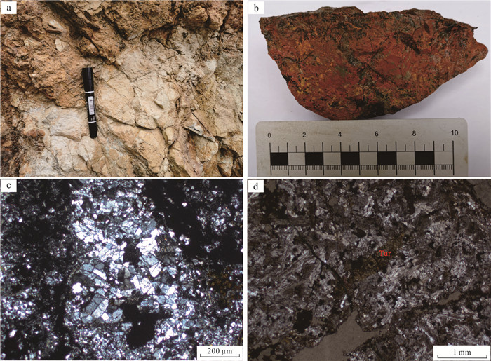
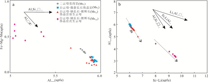
The Dahongliutan two-mica granite is considered as parental rock to the adjacent pegmatite-type lithium deposits such as Bailongshan. To constrain the magmatic-hydrothermal evolution of granite and associated pegmatites, we selected the penetrative minerals, mica and tourmaline, from two-mica granite and pegmatite with different degrees of mineralization, for backscattering observation (BSE) and electron probe microanalysis (EPMA). In the two-mica granite (Ms1) and muscovite-microcline pegmatite (Ms2), the muscovite is homogeneous, with limited chemical variations. In muscovite-albite-spodumene pegmatite, the muscovite (Ms3) incorporates much higher Li (Li2O up to 4.68%) and F (up to 6.47%) in comparison to Ms1 and Ms2. There are additional Li-bearing phengite, zinnwaldite and lepidolite that have replaced muscovite. Tourmalines from two-mica granite (Tur1) and muscovite-microcline pegmatite (Tur2) belong to alkaline schorl, while those from spodumene pegmatite (Tur3) are alkaline elbaite. Compared to alkaline schorl, alkaline elbaite is enriched in SiO2, Al2O3, Li2O, but depleted in TiO2, MgO and CaO. The textural and compositional features of mica and tourmaline reveal that the two-mica granite and muscovite-microcline pegmatite were formed by magmatic process, without lithium mineralization. By contrast, muscovite-albite-spodumene pegmatite was formed during the magmatic-hydrothermal transition, where lithium was significantly enriched, and numerous lithium-rich minerals such as spodumene, lithium-rich polysilicon muscovite, Li-bearing phengite, zinnwaldite, lepidolite and elbaite, were precipitated. Accordingly, we propose that the magmatic-hydrothermal transition is of great significance for lithium mineralization. In pegmatite-type deposits, the presence of elbaite and lepidolite indicates high degree of magmatic evolution.
The Dahongliutan two-mica granite is considered as parental rock to the adjacent pegmatite-type lithium deposits such as Bailongshan. To constrain the magmatic-hydrothermal evolution of granite and associated pegmatites, we selected the penetrative minerals, mica and tourmaline, from two-mica granite and pegmatite with different degrees of mineralization, for backscattering observation (BSE) and electron probe microanalysis (EPMA). In the two-mica granite (Ms1) and muscovite-microcline pegmatite (Ms2), the muscovite is homogeneous, with limited chemical variations. In muscovite-albite-spodumene pegmatite, the muscovite (Ms3) incorporates much higher Li (Li2O up to 4.68%) and F (up to 6.47%) in comparison to Ms1 and Ms2. There are additional Li-bearing phengite, zinnwaldite and lepidolite that have replaced muscovite. Tourmalines from two-mica granite (Tur1) and muscovite-microcline pegmatite (Tur2) belong to alkaline schorl, while those from spodumene pegmatite (Tur3) are alkaline elbaite. Compared to alkaline schorl, alkaline elbaite is enriched in SiO2, Al2O3, Li2O, but depleted in TiO2, MgO and CaO. The textural and compositional features of mica and tourmaline reveal that the two-mica granite and muscovite-microcline pegmatite were formed by magmatic process, without lithium mineralization. By contrast, muscovite-albite-spodumene pegmatite was formed during the magmatic-hydrothermal transition, where lithium was significantly enriched, and numerous lithium-rich minerals such as spodumene, lithium-rich polysilicon muscovite, Li-bearing phengite, zinnwaldite, lepidolite and elbaite, were precipitated. Accordingly, we propose that the magmatic-hydrothermal transition is of great significance for lithium mineralization. In pegmatite-type deposits, the presence of elbaite and lepidolite indicates high degree of magmatic evolution.


2024, 49(3): 939-951.
doi: 10.3799/dqkx.2022.232
Abstract:
To ascertain the salinity origin and evolution of aquitard porewater in the coastal zone, this paper collected four borehole core samples in the Laizhou Bay, Lianyungang City, and porewater was then extracted by mechanical squeezing. The chemical and isotopic components of porewater were measured and a solute transport model of porewater since Holocene in a 2D typical section was established. The results show that the total dissolved solids of porewater range from 0.9 to 41.4 g/L from land to sea, and it is higher in shallower sediments and lower in deeper ones. Porewater has Cl/Br ratio of 170-533 (267 in average) and 87Sr/86Sr of 0.709 3-0.711 6, together with the positive correlation between Cl‒ and δ18O, indicating that saline porewater is of marine origin and has been affected by silicate weathering and cation exchange. In the Holocene aquitard, porewater is trapped ancient seawater in 10-5 ka BP and the downward infiltration led to salinization of the underlying Pleistocene porewater. About 4 ka BP, porewater was diluted by freshwater in the regression, yet paleo-seawater has not been totally flushed. While in the area close to the coastline, the continuous evaporation led to the occurrence of much saltier porewater. Porewater simulation suggests that aquitard porewater salinity evolution is mainly controlled by transgression-regression events, and during transgression, seawater downward invaded in a "finger-like" pattern, resulting in the heterogeneous distribution of brackish and fresh groundwater.
To ascertain the salinity origin and evolution of aquitard porewater in the coastal zone, this paper collected four borehole core samples in the Laizhou Bay, Lianyungang City, and porewater was then extracted by mechanical squeezing. The chemical and isotopic components of porewater were measured and a solute transport model of porewater since Holocene in a 2D typical section was established. The results show that the total dissolved solids of porewater range from 0.9 to 41.4 g/L from land to sea, and it is higher in shallower sediments and lower in deeper ones. Porewater has Cl/Br ratio of 170-533 (267 in average) and 87Sr/86Sr of 0.709 3-0.711 6, together with the positive correlation between Cl‒ and δ18O, indicating that saline porewater is of marine origin and has been affected by silicate weathering and cation exchange. In the Holocene aquitard, porewater is trapped ancient seawater in 10-5 ka BP and the downward infiltration led to salinization of the underlying Pleistocene porewater. About 4 ka BP, porewater was diluted by freshwater in the regression, yet paleo-seawater has not been totally flushed. While in the area close to the coastline, the continuous evaporation led to the occurrence of much saltier porewater. Porewater simulation suggests that aquitard porewater salinity evolution is mainly controlled by transgression-regression events, and during transgression, seawater downward invaded in a "finger-like" pattern, resulting in the heterogeneous distribution of brackish and fresh groundwater.


2024, 49(3): 952-964.
doi: 10.3799/dqkx.2022.225
Abstract:
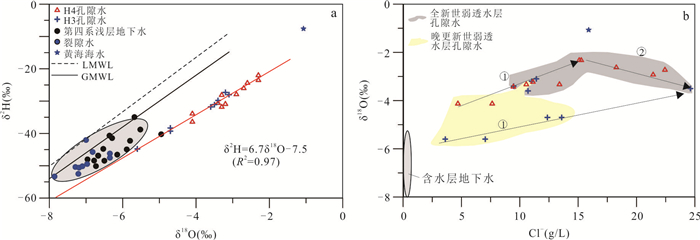
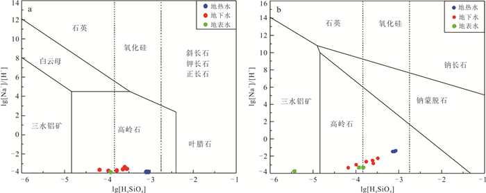
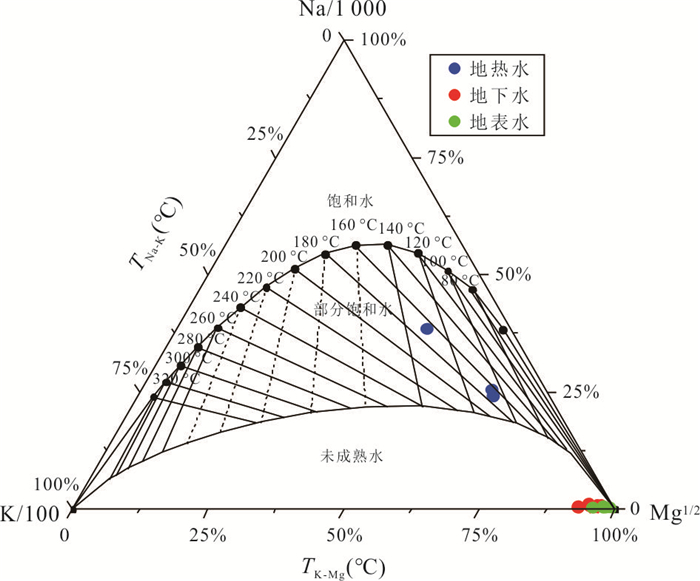
The understanding of the formation and evolution of geothermal water is an important basis for the scientific and rational utilization of regional geothermal resources. In this paper, the hydrochemical characteristics, geothermal storage temperature and recharge source of geothermal water in Guantang area on the east coast of Hainan were systematically revealed by using hydrochemical and isotopic analysis methods combined with regional geological structure characteristics, and a conceptual model of geothermal water cycle evolution in Guantang area was constructed. The results show that the hydrochemistry of geothermal water was mainly HCO3·SO4-Na type, and its components mainly came from silicate mineral dissolution and deep gas components. Geothermal water was mainly originated from meteoric precipitation, and the recharge area was most likely located at the altitude of 1 122.2-1 569.4 m. There was a significant mixing effect between geothermal water and shallow groundwater. Under the condition of steam loss before mixing, the mass percentage of steam loss from geothermal water was 18.2%-25.2%, and the initial temperature of geothermal water was 190.4-217.8 ℃, and the mass percentage of cold water mixing to geothermal water was 66.8%-80.8%. The geothermal water level decreased greatly with the increasing geothermal water exploration in this area in recent decades, so the increase of shallow groundwater supply may be the crucial process resulting in the decrease of geothermal water temperature in this area.
The understanding of the formation and evolution of geothermal water is an important basis for the scientific and rational utilization of regional geothermal resources. In this paper, the hydrochemical characteristics, geothermal storage temperature and recharge source of geothermal water in Guantang area on the east coast of Hainan were systematically revealed by using hydrochemical and isotopic analysis methods combined with regional geological structure characteristics, and a conceptual model of geothermal water cycle evolution in Guantang area was constructed. The results show that the hydrochemistry of geothermal water was mainly HCO3·SO4-Na type, and its components mainly came from silicate mineral dissolution and deep gas components. Geothermal water was mainly originated from meteoric precipitation, and the recharge area was most likely located at the altitude of 1 122.2-1 569.4 m. There was a significant mixing effect between geothermal water and shallow groundwater. Under the condition of steam loss before mixing, the mass percentage of steam loss from geothermal water was 18.2%-25.2%, and the initial temperature of geothermal water was 190.4-217.8 ℃, and the mass percentage of cold water mixing to geothermal water was 66.8%-80.8%. The geothermal water level decreased greatly with the increasing geothermal water exploration in this area in recent decades, so the increase of shallow groundwater supply may be the crucial process resulting in the decrease of geothermal water temperature in this area.


2024, 49(3): 965-977.
doi: 10.3799/dqkx.2022.425
Abstract:
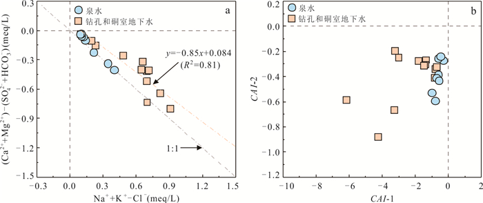
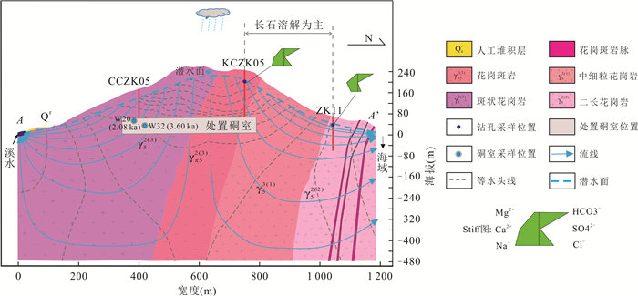
Hydrochemical characteristics are one of the most critical evaluation factors for the site selection and long-term performance safety evaluation of nuclear facilities. Mathematical statistics, ion proportion method, isotope analysis method, and hydrogeochemical simulation were used in this paper to investigate hydrochemical characteristics of an underground nuclear facility site along the coast. Its hydrochemical characteristics, possible controls, groundwater recharge source, and apparent age were analyzed. Furthermore, the conceptual model of groundwater flow and hydrochemical evolution in the area was preliminarily constructed. The results suggest that the total dissolved solids (TDS) of the groundwater is low, and the pH value in most samples is weakly acidic. The hydrochemical types of groundwater sampling from boreholes and tunnels are mainly HCO3-Na·Ca and HCO3-Ca·Na. The weathering of silicate rocks specifically controls hydrochemical components. Moreover, the weathering dissolution of albite and anorthite is the primary water-rock interaction of groundwater along unconfined aquifer main runoff paths. The groundwater source is the infiltration recharge of local atmospheric precipitation, and the 14C apparent age in the depth range of nuclear facilities is about 2.08-3.60 ka. It is concluded that the hydrochemistry and groundwater circulation conditions at the site are beneficial to ensure the safety of underground nuclear facilities.
Hydrochemical characteristics are one of the most critical evaluation factors for the site selection and long-term performance safety evaluation of nuclear facilities. Mathematical statistics, ion proportion method, isotope analysis method, and hydrogeochemical simulation were used in this paper to investigate hydrochemical characteristics of an underground nuclear facility site along the coast. Its hydrochemical characteristics, possible controls, groundwater recharge source, and apparent age were analyzed. Furthermore, the conceptual model of groundwater flow and hydrochemical evolution in the area was preliminarily constructed. The results suggest that the total dissolved solids (TDS) of the groundwater is low, and the pH value in most samples is weakly acidic. The hydrochemical types of groundwater sampling from boreholes and tunnels are mainly HCO3-Na·Ca and HCO3-Ca·Na. The weathering of silicate rocks specifically controls hydrochemical components. Moreover, the weathering dissolution of albite and anorthite is the primary water-rock interaction of groundwater along unconfined aquifer main runoff paths. The groundwater source is the infiltration recharge of local atmospheric precipitation, and the 14C apparent age in the depth range of nuclear facilities is about 2.08-3.60 ka. It is concluded that the hydrochemistry and groundwater circulation conditions at the site are beneficial to ensure the safety of underground nuclear facilities.


2024, 49(3): 978-991.
doi: 10.3799/dqkx.2022.242
Abstract:
Saturated hydraulic conductivity is a significant soil hydraulic parameter, which plays an important role in the research of seepage and solute transport. Pdeo-Transfer Functions (PTFs) can indirectly predict this parameter instead of large-scale sampling and indoor and outdoor tests. However, due to the spatial variability of soils and the limitations of methods, previous predictions of PTFs are not accurate enough. This study takes different soil layers in the vadose zone of Yanlou Township, Lankao County, the lower reaches of the Yellow River as the research object. Based on 64 borehole data, nine basic physicochemical properties such as soil particle size distribution (clay, silt and sand content), soil structure fractal dimension, dry bulk density, total porosity, pH value, organic matter and electrical conductivity are considered as the influencing factors of the PTFs. Based on Stepwise Regression, Principal Component Regression and Principal Component Analysis-Geographically Weighted Regression (PCA-GWR), the saturated hydraulic conductivity of different soil layers is regressed separately. After comparison of precision, Geographically Weighted Regression Kriging is carried out for saturated hydraulic conductivity based on PCA-GWR. The results reveal that the prediction accuracy of PCA-GWR method has significant advantages except for the surface silt. The difference of the distribution of saturated hydraulic conductivity and PTFs in different soil layers shows that, due to the rapid and changeable sedimentation process in the lower reaches of the Yellow River, the breach and diversion of the Yellow River and human activities, the phase change of soil layer in the vadose zone is intense, and the saturated hydraulic conductivity also has obvious non-stationary characteristics in the plane. The local geological process and human activities are the deep reasons for the poor regression Kriging estimation results of the second layer of silt.
Saturated hydraulic conductivity is a significant soil hydraulic parameter, which plays an important role in the research of seepage and solute transport. Pdeo-Transfer Functions (PTFs) can indirectly predict this parameter instead of large-scale sampling and indoor and outdoor tests. However, due to the spatial variability of soils and the limitations of methods, previous predictions of PTFs are not accurate enough. This study takes different soil layers in the vadose zone of Yanlou Township, Lankao County, the lower reaches of the Yellow River as the research object. Based on 64 borehole data, nine basic physicochemical properties such as soil particle size distribution (clay, silt and sand content), soil structure fractal dimension, dry bulk density, total porosity, pH value, organic matter and electrical conductivity are considered as the influencing factors of the PTFs. Based on Stepwise Regression, Principal Component Regression and Principal Component Analysis-Geographically Weighted Regression (PCA-GWR), the saturated hydraulic conductivity of different soil layers is regressed separately. After comparison of precision, Geographically Weighted Regression Kriging is carried out for saturated hydraulic conductivity based on PCA-GWR. The results reveal that the prediction accuracy of PCA-GWR method has significant advantages except for the surface silt. The difference of the distribution of saturated hydraulic conductivity and PTFs in different soil layers shows that, due to the rapid and changeable sedimentation process in the lower reaches of the Yellow River, the breach and diversion of the Yellow River and human activities, the phase change of soil layer in the vadose zone is intense, and the saturated hydraulic conductivity also has obvious non-stationary characteristics in the plane. The local geological process and human activities are the deep reasons for the poor regression Kriging estimation results of the second layer of silt.


2024, 49(3): 992-1004.
doi: 10.3799/dqkx.2022.430
Abstract:
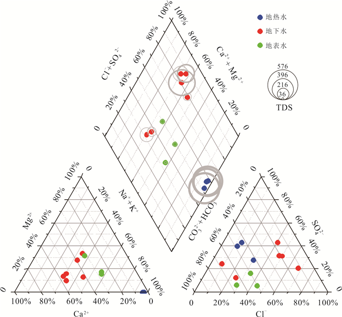
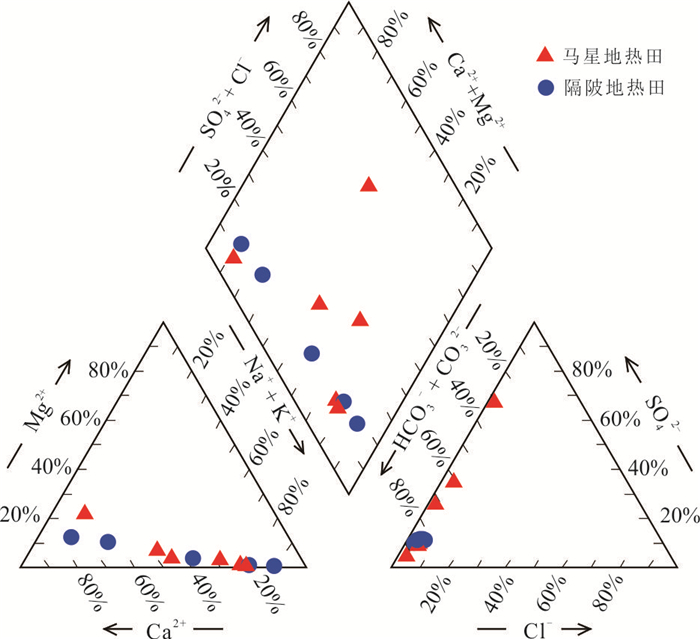
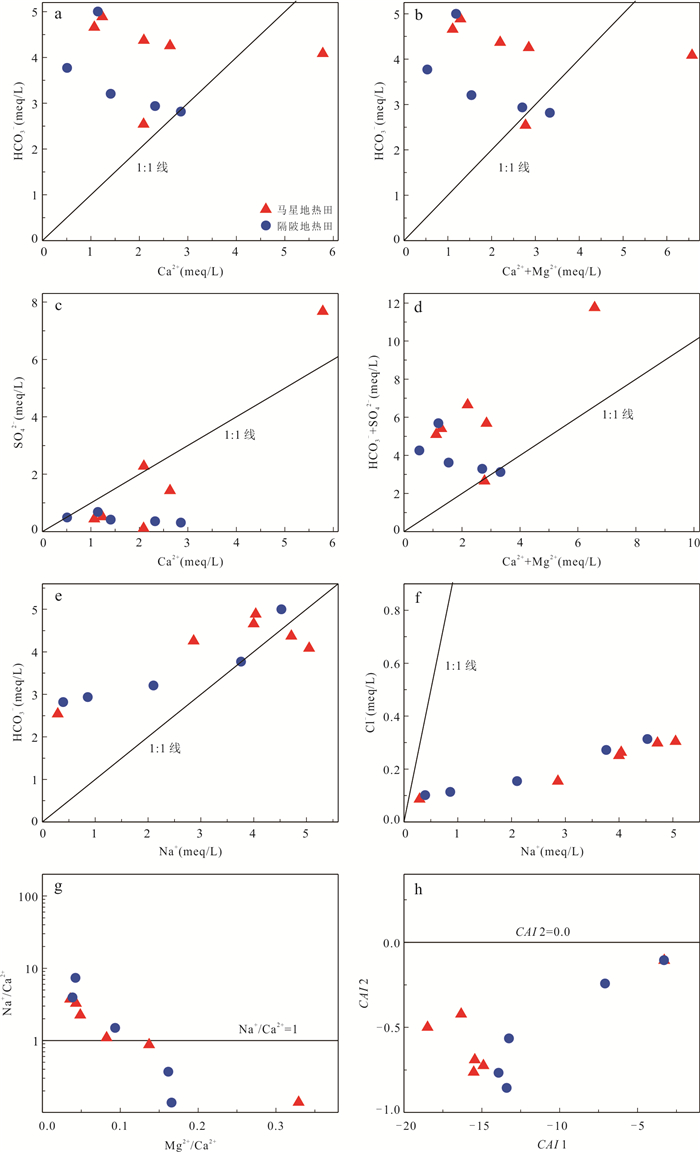
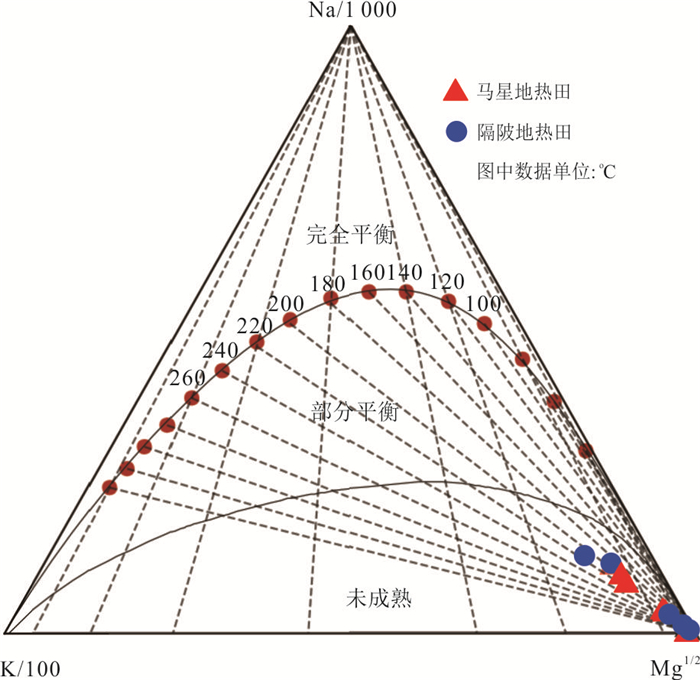
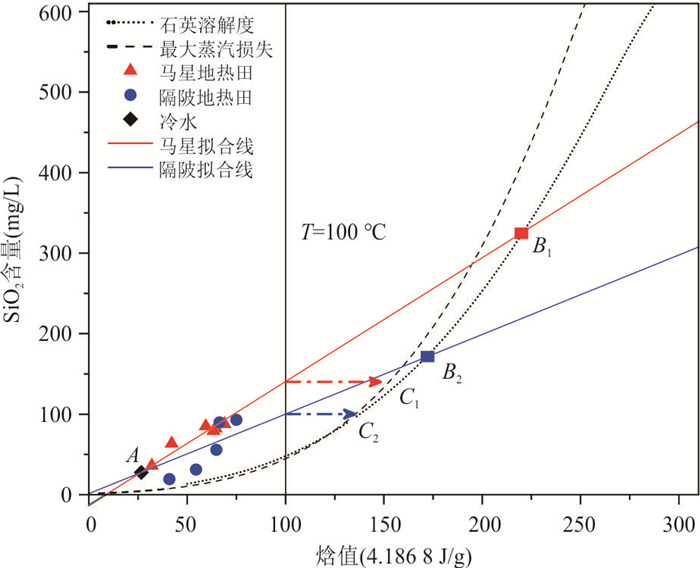
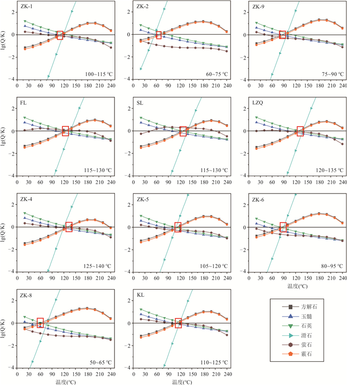
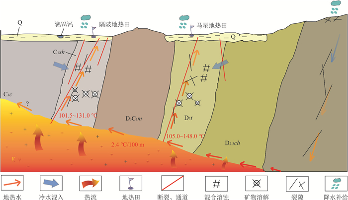
Karst geothermal systems hold enormous potential for geothermal exploitation. The Maxing and Gepi geothermal anomaly areas are typical geothermal fields in Longmen County, Guangdong Province. The temperature and fluid evolution of geothermal reservoir can be clarified, with the analysis of ion ratio relationship, δD and δ18O isotopes, and geothermal thermometers et.al. It is indicated that silicate minerals, carbonate minerals such as calcite dissolution, and accompanying cation exchange control the hydrochemistry evolution, thus forming slightly alkaline HCO3-type geothermal water with lower TDS in the study area. The results suggest that atmospheric precipitation is the main recharge source. The reservoir temperature is 105.0-148.0 ℃ and 101.5-131.0 ℃ for Maxing and Gepi geothermal reservoir respectively, with a lower temperature during upwelling caused by mixing with cold water up to 44.2% and 48.5% dilution. In this case, a conceptual model for geothermal fluid evolution is proposed based on the geothermal water hydrochemistry and reservoir temperature characteristics.
Karst geothermal systems hold enormous potential for geothermal exploitation. The Maxing and Gepi geothermal anomaly areas are typical geothermal fields in Longmen County, Guangdong Province. The temperature and fluid evolution of geothermal reservoir can be clarified, with the analysis of ion ratio relationship, δD and δ18O isotopes, and geothermal thermometers et.al. It is indicated that silicate minerals, carbonate minerals such as calcite dissolution, and accompanying cation exchange control the hydrochemistry evolution, thus forming slightly alkaline HCO3-type geothermal water with lower TDS in the study area. The results suggest that atmospheric precipitation is the main recharge source. The reservoir temperature is 105.0-148.0 ℃ and 101.5-131.0 ℃ for Maxing and Gepi geothermal reservoir respectively, with a lower temperature during upwelling caused by mixing with cold water up to 44.2% and 48.5% dilution. In this case, a conceptual model for geothermal fluid evolution is proposed based on the geothermal water hydrochemistry and reservoir temperature characteristics.


2024, 49(3): 1005-1016.
doi: 10.3799/dqkx.2022.198
Abstract:
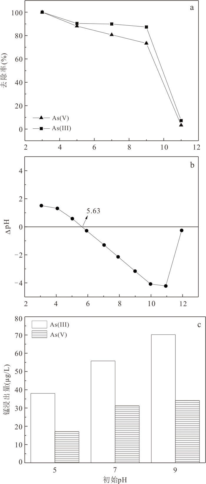
High arsenic groundwater is widely distributed in China, and it is of great significance to develop green and efficient arsenic removal materials for the sake of regional development and safety of drinking water for residents. In this study, the fly ash modified with manganese dioxide (MFA150) was prepared using co-precipitation method combined with NaOH hydrothermal process, to investigate its adsorption of As(Ⅲ) and As(Ⅴ) in groundwater. The results show that the vitreous structure of the raw fly ash was destroyed to generate zeolite phase in NaOH hydrothermal process, and the specific surface area of fly ash increased from 1.30 m2/g to 40.26 m2/g. After loading MnO2, the specific surface area of the adsorbent further increased to 148.82 m2/g, and the content of -OH on the surface was significantly increased to provide more adsorption sites for As(Ⅲ) and As(Ⅴ). The adsorption of As(Ⅲ) and As(Ⅴ) was in accordance with the Elovich model and the Freundlich model. The adsorption capacities of MFA150 for As(Ⅴ) and As(Ⅲ) under neutral condition were 2.55 mg/g and 9.71 mg/g, respectively, and showed stronger adsorption ability under acidic condition. Coexisting HCO3‒ and PO43‒ inhibited the adsorption of As(Ⅲ) and As(Ⅴ), while SO42‒ slightly promoted the removal of As(Ⅲ) and As(Ⅴ). In simulated groundwater, the removal rate of total As reached 91.90% by MFA150. Since preparation of MFA150 is simple and the raw material is cheap and easy to obtain, MFA150 is expected to be used in the treatment of the high arsenic groundwater owing to the better adsorption performance for As(Ⅴ) and As(Ⅲ).
High arsenic groundwater is widely distributed in China, and it is of great significance to develop green and efficient arsenic removal materials for the sake of regional development and safety of drinking water for residents. In this study, the fly ash modified with manganese dioxide (MFA150) was prepared using co-precipitation method combined with NaOH hydrothermal process, to investigate its adsorption of As(Ⅲ) and As(Ⅴ) in groundwater. The results show that the vitreous structure of the raw fly ash was destroyed to generate zeolite phase in NaOH hydrothermal process, and the specific surface area of fly ash increased from 1.30 m2/g to 40.26 m2/g. After loading MnO2, the specific surface area of the adsorbent further increased to 148.82 m2/g, and the content of -OH on the surface was significantly increased to provide more adsorption sites for As(Ⅲ) and As(Ⅴ). The adsorption of As(Ⅲ) and As(Ⅴ) was in accordance with the Elovich model and the Freundlich model. The adsorption capacities of MFA150 for As(Ⅴ) and As(Ⅲ) under neutral condition were 2.55 mg/g and 9.71 mg/g, respectively, and showed stronger adsorption ability under acidic condition. Coexisting HCO3‒ and PO43‒ inhibited the adsorption of As(Ⅲ) and As(Ⅴ), while SO42‒ slightly promoted the removal of As(Ⅲ) and As(Ⅴ). In simulated groundwater, the removal rate of total As reached 91.90% by MFA150. Since preparation of MFA150 is simple and the raw material is cheap and easy to obtain, MFA150 is expected to be used in the treatment of the high arsenic groundwater owing to the better adsorption performance for As(Ⅴ) and As(Ⅲ).


2024, 49(3): 1017-1027.
doi: 10.3799/dqkx.2022.424
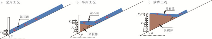
Abstract:
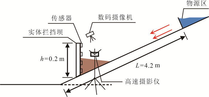
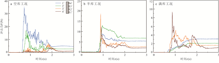
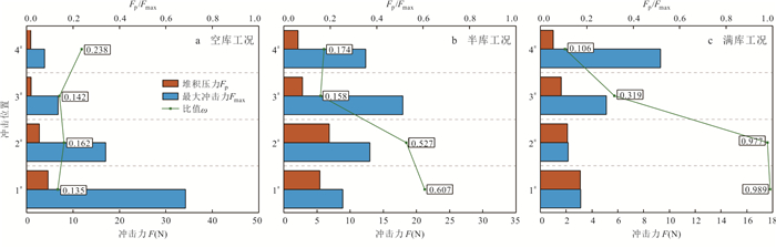
Effective reservoir capacity of retaining dam and impact force of debris flow are important indexes for the design of entity check dam of debris flow. Deposits or even fills in the existing entity check dam under repeated impact of debris flows, have great influence on the control ability of dam body. In this paper, based on theoretical analysis and physical model test, dynamic response of debris flow impinging entity check dam under the condition of silting behind dam is studied, dimensionless calculation formulas of velocity attenuation rate and retaining rate of dam body under the condition of silting behind dam are derived, and calculation model of impact force of debris flow under the condition of silting behind dam considering spatial distribution characteristics is established. The results show that the velocity attenuation rate and dam retaining rate of debris flow are positively correlated with the ratio of silt height to silt length and the relative density of debris flow. The combined calculation model of impact force and static and dynamic load of debris flow can better reflect the composition and distribution of impact force of debris flow under the condition of silting behind the dam. This study can provide theoretical and technical support for the design of solid debris flow retaining dam engineering.
Effective reservoir capacity of retaining dam and impact force of debris flow are important indexes for the design of entity check dam of debris flow. Deposits or even fills in the existing entity check dam under repeated impact of debris flows, have great influence on the control ability of dam body. In this paper, based on theoretical analysis and physical model test, dynamic response of debris flow impinging entity check dam under the condition of silting behind dam is studied, dimensionless calculation formulas of velocity attenuation rate and retaining rate of dam body under the condition of silting behind dam are derived, and calculation model of impact force of debris flow under the condition of silting behind dam considering spatial distribution characteristics is established. The results show that the velocity attenuation rate and dam retaining rate of debris flow are positively correlated with the ratio of silt height to silt length and the relative density of debris flow. The combined calculation model of impact force and static and dynamic load of debris flow can better reflect the composition and distribution of impact force of debris flow under the condition of silting behind the dam. This study can provide theoretical and technical support for the design of solid debris flow retaining dam engineering.


2024, 49(3): 1028-1038.
doi: 10.3799/dqkx.2022.211
Abstract:
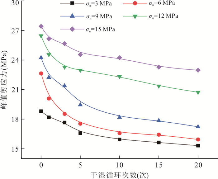
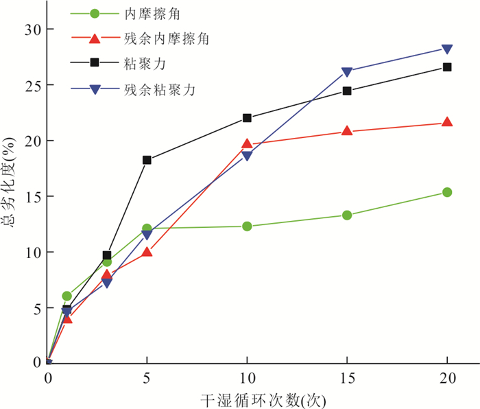
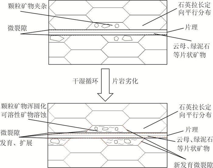
The deterioration of shear properties of schist under dry-wet cycles has an important effect on the long-term stability of schist slope. Taking the mica-quartz schist widely distributed in Northwest Hubei as the research object, a series of laboratory tests were carried out to reveal the law and mechanism of its shear deterioration. The results of water absorption tests and direct shear tests show that the water absorption of mica-quartz schist increases, while the shear strength and residual shear strength decrease gradually with the increase of the number of dry-wet cycles, and the shear properties show obvious deterioration effect. Based on the changes of mica-quartz schist microstructure obtained by scanning electron microscopy, the deterioration mechanism of mica-quartz schist is revealed. Under the action of dry-wet cycles, the schist plane gradually expands and cracks, the strength of internal mineral particles is softened, the cementation between particles is weakened, and the rock skeleton becomes loose. What's more, the cohesion is mainly affected by the degree of cementation between mineral particles, so the deterioration rate is fast. While the internal friction angle is mainly affected by the degree of embeddedness and the strength of mineral particles, so the deterioration rate is relatively slow.
The deterioration of shear properties of schist under dry-wet cycles has an important effect on the long-term stability of schist slope. Taking the mica-quartz schist widely distributed in Northwest Hubei as the research object, a series of laboratory tests were carried out to reveal the law and mechanism of its shear deterioration. The results of water absorption tests and direct shear tests show that the water absorption of mica-quartz schist increases, while the shear strength and residual shear strength decrease gradually with the increase of the number of dry-wet cycles, and the shear properties show obvious deterioration effect. Based on the changes of mica-quartz schist microstructure obtained by scanning electron microscopy, the deterioration mechanism of mica-quartz schist is revealed. Under the action of dry-wet cycles, the schist plane gradually expands and cracks, the strength of internal mineral particles is softened, the cementation between particles is weakened, and the rock skeleton becomes loose. What's more, the cohesion is mainly affected by the degree of cementation between mineral particles, so the deterioration rate is fast. While the internal friction angle is mainly affected by the degree of embeddedness and the strength of mineral particles, so the deterioration rate is relatively slow.


2024, 49(3): 1039-1051.
doi: 10.3799/dqkx.2022.233
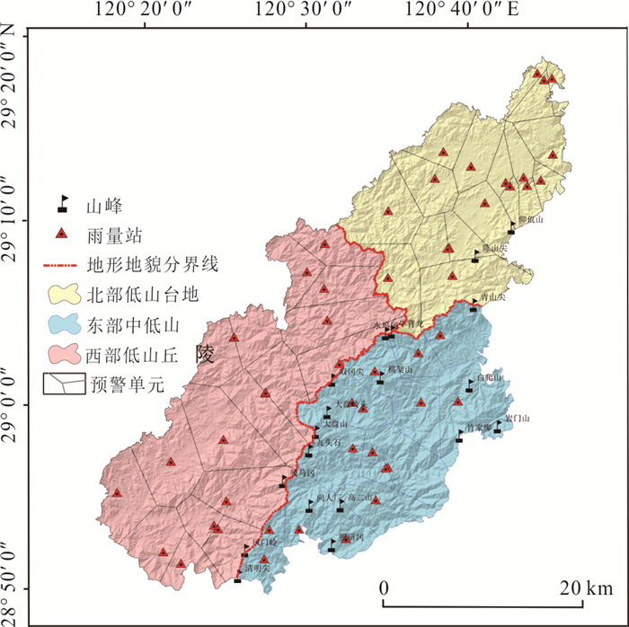
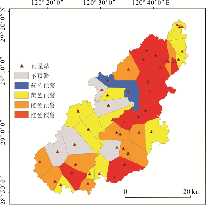
Abstract:
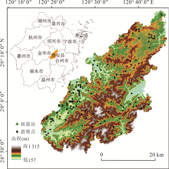
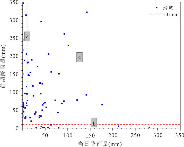
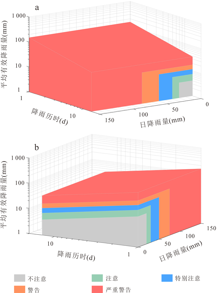
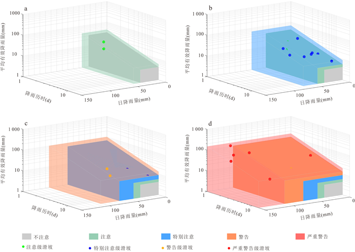
The establishment of the multi-dimensional meteorological early warning criterion of landslide and the division of the "grid" early warning unit can provide a scientific basis for the landslide early warning, for the purpose of which 205 rainfall-induced landslides in Panan County, Zhejiang Province were studied in this paper. Firstly, based on the average effective rainfall intensity-diachronic (I-D) threshold model, the critical threshold curves were divided by ordinary least squares regression (OLSQ) and quantile regression (QR). Secondly, the I-D-R threshold model was established by the I-D threshold model optimized by considering the daily rainfall (R), and different parameter estimation methods were used to compare the accuracy of different threshold models. The optimal threshold model was considered as the meteorological early warning criterion for landslide disasters in Pan'an County. Finally, considering the difference of rainfall distribution, the township level grid early warning unit was established by the terrain zoning and Voronoi diagram (VD) of Pan'an. The results show that: (1) The I⁃D⁃R threshold model has better early warning accuracy than the I⁃D model. The I⁃D⁃R threshold model based on QR has a better warning ability, and the accuracy of the threshold degree of warning and above is increased to 50%, and the accuracy of the threshold level of special attention and above is increased to 88.9%; (2) the rainfall conditions with I⁃D⁃R based on QR rainfall threshold are proposed as the early warning criteria (red, orange, yellow and blue) of 51 early warning units in Pan'an County, and the emergency response measures are put forward. A new threshold model is established on the basis of the research results, which can provide reference for regional meteorological early warning in Pan'an County.
The establishment of the multi-dimensional meteorological early warning criterion of landslide and the division of the "grid" early warning unit can provide a scientific basis for the landslide early warning, for the purpose of which 205 rainfall-induced landslides in Panan County, Zhejiang Province were studied in this paper. Firstly, based on the average effective rainfall intensity-diachronic (I-D) threshold model, the critical threshold curves were divided by ordinary least squares regression (OLSQ) and quantile regression (QR). Secondly, the I-D-R threshold model was established by the I-D threshold model optimized by considering the daily rainfall (R), and different parameter estimation methods were used to compare the accuracy of different threshold models. The optimal threshold model was considered as the meteorological early warning criterion for landslide disasters in Pan'an County. Finally, considering the difference of rainfall distribution, the township level grid early warning unit was established by the terrain zoning and Voronoi diagram (VD) of Pan'an. The results show that: (1) The I⁃D⁃R threshold model has better early warning accuracy than the I⁃D model. The I⁃D⁃R threshold model based on QR has a better warning ability, and the accuracy of the threshold degree of warning and above is increased to 50%, and the accuracy of the threshold level of special attention and above is increased to 88.9%; (2) the rainfall conditions with I⁃D⁃R based on QR rainfall threshold are proposed as the early warning criteria (red, orange, yellow and blue) of 51 early warning units in Pan'an County, and the emergency response measures are put forward. A new threshold model is established on the basis of the research results, which can provide reference for regional meteorological early warning in Pan'an County.


2024, 49(3): 1052-1065.
doi: 10.3799/dqkx.2022.230
Abstract:
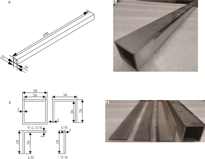
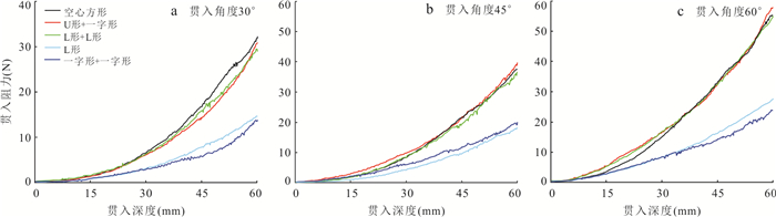
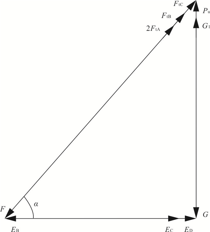
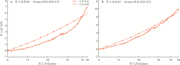
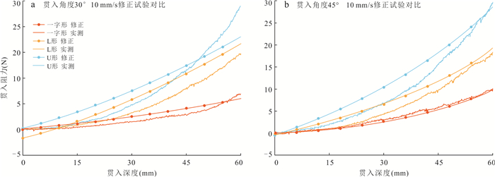
To understand the interaction between sampling machines and lunar soil simulant, and to verify the feasibility of modular modeling of lunar soil sampling machines. The experimental study on mechanical penetration load under different conditions was carried out, based on the CUG-1A lunar soil simulant developed by China University of Geosciences (Wuhan), and the theoretical model was established based on the experimental results for verification. The average growth rate of penetration resistance of each machine in the shallow simulation of lunar soil was 19.9%, which was increased to 38.18% in the shallow simulation, and 63.43% in the deep simulation. The average error of penetration velocity to penetration resistance was 2.5%; the average growth rate between penetration angle and penetration resistance was 62.85%; the penetration resistance of different cross-section machines was approximately 1∶2∶3∶4. At the same time, the modular verification of the machine structure was carried out, and the accuracy of the test and model can reach more than 85%. The penetration resistance of sampling machines is significantly correlated with penetration depth, mode and machine structure, and the modular theoretical model can be established to accurately predict the penetration resistance of machines under different conditions.
To understand the interaction between sampling machines and lunar soil simulant, and to verify the feasibility of modular modeling of lunar soil sampling machines. The experimental study on mechanical penetration load under different conditions was carried out, based on the CUG-1A lunar soil simulant developed by China University of Geosciences (Wuhan), and the theoretical model was established based on the experimental results for verification. The average growth rate of penetration resistance of each machine in the shallow simulation of lunar soil was 19.9%, which was increased to 38.18% in the shallow simulation, and 63.43% in the deep simulation. The average error of penetration velocity to penetration resistance was 2.5%; the average growth rate between penetration angle and penetration resistance was 62.85%; the penetration resistance of different cross-section machines was approximately 1∶2∶3∶4. At the same time, the modular verification of the machine structure was carried out, and the accuracy of the test and model can reach more than 85%. The penetration resistance of sampling machines is significantly correlated with penetration depth, mode and machine structure, and the modular theoretical model can be established to accurately predict the penetration resistance of machines under different conditions.


2024, 49(3): 1066-1080.
doi: 10.3799/dqkx.2022.185
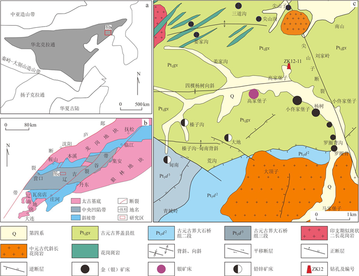
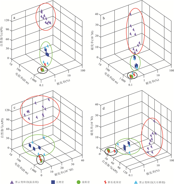
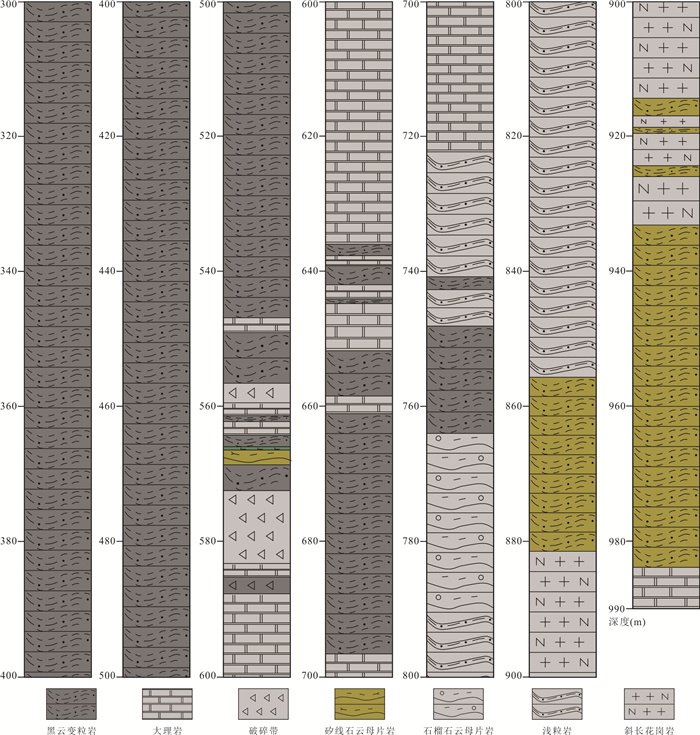
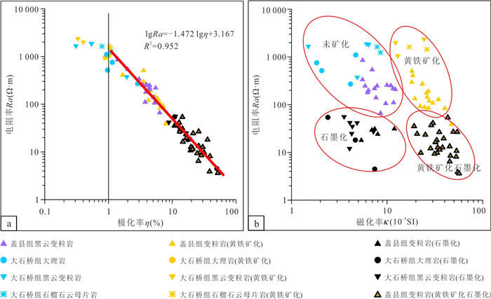
Abstract:
Liaodong is an important gold producing area in China, and it has become a key research direction to achieve a new breakthrough in deep prospecting here. Geophysical method is the main technical means to discover and detect deep gold deposits. In order to finely characterize the stratigraphic structure of Qingchengzi ore concentration area, accurately reveal the geophysical anomalous characteristics of deep mineralized alteration zone, and establish the geophysical interpretation scale for deep prospecting, multi-parameter geophysical logging and borehole geophysical survey were carried out in ZK12-11 hole in Xiaotongjiabuzi gold mining area. Combined with drill core logging, the response characteristics of lithology and mineralized alteration zone of 300-990 m well section of the hole were analyzed by histogram and crossplot, and the drilling lithology profile and mineralized alteration layer were divided. The results show that the four parameters of natural gamma, apparent resistivity, magnetic susceptibility and polarizability can distinguish the main lithology of borehole, and can be used as the main basis for reconstructing the lithology profile of borehole. The content of pyrite in the pyritization layer is not high enough to cause the decrease of formation resistivity. Graphitization is the main factor causing the decrease of resistivity. The natural gamma high-low transition zone and the low resistivity and high polarization non-magnetic anomaly zone are the prospecting signs of geophysical logging for gold prospecting in Xiaotongjiabuzi gold deposit. Geophysical logging can effectively delineate favorable horizons for gold prospecting, and guide the deep prospecting work of gold deposit more accurately, which should be paid extensive attention.
Liaodong is an important gold producing area in China, and it has become a key research direction to achieve a new breakthrough in deep prospecting here. Geophysical method is the main technical means to discover and detect deep gold deposits. In order to finely characterize the stratigraphic structure of Qingchengzi ore concentration area, accurately reveal the geophysical anomalous characteristics of deep mineralized alteration zone, and establish the geophysical interpretation scale for deep prospecting, multi-parameter geophysical logging and borehole geophysical survey were carried out in ZK12-11 hole in Xiaotongjiabuzi gold mining area. Combined with drill core logging, the response characteristics of lithology and mineralized alteration zone of 300-990 m well section of the hole were analyzed by histogram and crossplot, and the drilling lithology profile and mineralized alteration layer were divided. The results show that the four parameters of natural gamma, apparent resistivity, magnetic susceptibility and polarizability can distinguish the main lithology of borehole, and can be used as the main basis for reconstructing the lithology profile of borehole. The content of pyrite in the pyritization layer is not high enough to cause the decrease of formation resistivity. Graphitization is the main factor causing the decrease of resistivity. The natural gamma high-low transition zone and the low resistivity and high polarization non-magnetic anomaly zone are the prospecting signs of geophysical logging for gold prospecting in Xiaotongjiabuzi gold deposit. Geophysical logging can effectively delineate favorable horizons for gold prospecting, and guide the deep prospecting work of gold deposit more accurately, which should be paid extensive attention.


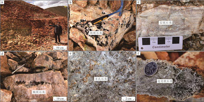
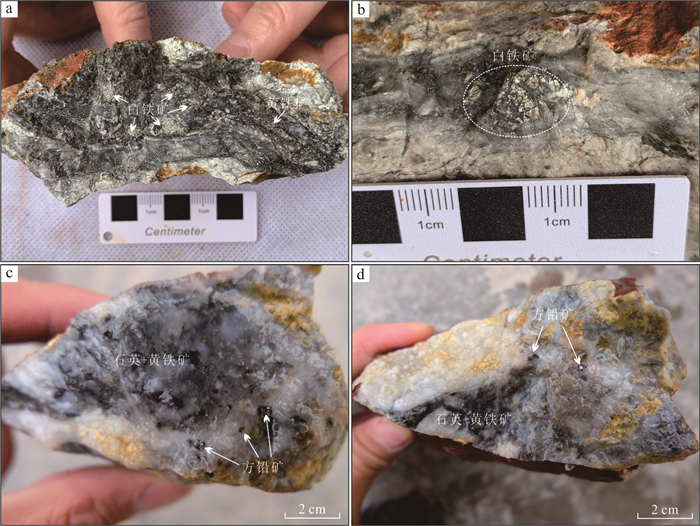
2024, 49(3): 1081-1103.
doi: 10.3799/dqkx.2022.195
Abstract:
In recent years, many medium-large Pb-Zn-Ag deposits have been found in the Linzizong volcanic rocks in the Gangdese Nyainqêntanglha metallogenic belt, showing great potential for exploration. However, the key to exploration is how to conduct exploration targeting in the widespread Linzizong volcanic rocks. In this contribution, we conduct work of geochemical survey and induced polarization intermediate gradient in the Sinongduo Ag polymetallic deposit in the Dianzhong volcanic rocks. The results show that the Pb-Zn-Ag mineralization in the Linzizong volcanic rocks has Au, Mo, Pb, Zn and Ag anomalies, and the Au-Ag mineralization has strong Au, Ag, Mo, As and Sb anomalies, and the variation coefficient of the main mineralizing elements is more than 3. The target of the potential epithermal Pb-Zn-Ag mineralization is given based on the > 2.5% polarizability and the < 800 Ω·m resistivity, which has achieved good exploration results. Our findings demonstrate that the induced polarization (IP) intermediate gradient is effective in exploration for epithermal Pb-Zn-Ag deposits in the Linzizong volcanic rocks, and thus can provide an important guide for the exploration in the Linzizong volcanic rocks in the Gangdese Nyainqêntanglha metallogenic belt.
In recent years, many medium-large Pb-Zn-Ag deposits have been found in the Linzizong volcanic rocks in the Gangdese Nyainqêntanglha metallogenic belt, showing great potential for exploration. However, the key to exploration is how to conduct exploration targeting in the widespread Linzizong volcanic rocks. In this contribution, we conduct work of geochemical survey and induced polarization intermediate gradient in the Sinongduo Ag polymetallic deposit in the Dianzhong volcanic rocks. The results show that the Pb-Zn-Ag mineralization in the Linzizong volcanic rocks has Au, Mo, Pb, Zn and Ag anomalies, and the Au-Ag mineralization has strong Au, Ag, Mo, As and Sb anomalies, and the variation coefficient of the main mineralizing elements is more than 3. The target of the potential epithermal Pb-Zn-Ag mineralization is given based on the > 2.5% polarizability and the < 800 Ω·m resistivity, which has achieved good exploration results. Our findings demonstrate that the induced polarization (IP) intermediate gradient is effective in exploration for epithermal Pb-Zn-Ag deposits in the Linzizong volcanic rocks, and thus can provide an important guide for the exploration in the Linzizong volcanic rocks in the Gangdese Nyainqêntanglha metallogenic belt.


2024, 49(3): 1104-1118.
doi: 10.3799/dqkx.2023.016
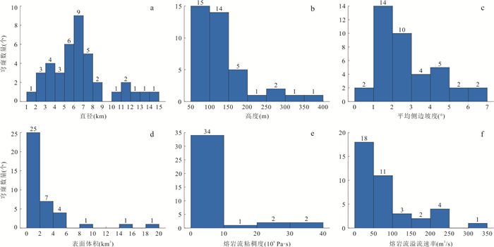
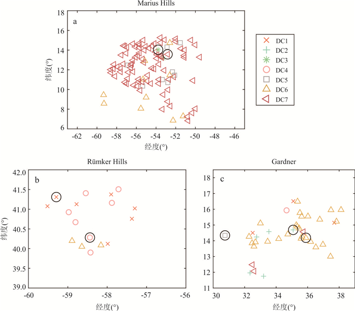
Abstract:
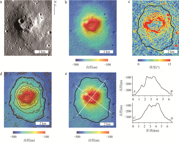
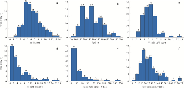
Lunar volcanic domes are essential windows into the volcanic activities of the Moon. This study uses high-resolution multi-source remote sensing data to extract the morphological features and Fe-Ti contents of volcanic domes developed in the three large volcanic complexes (Marius Hills and Rümker Hills in the PKT region, and Gardner outside the PKT area) on the lunar nearside. Hierarchical clustering analysis is performed with these parameters and all domes are classified into seven dome clusters (DC1‒DC7). Comprehensive analyses of the rheology, chronology, and geological background of the three large volcanic complexes are carried out. Our results show that the Marius Hills developed a large number of volcanic domes with large height and slope, dominated by medium to high TiO2 contents, and the representative group of the domes is DC7. The geological age of the Marius Hills has a wide time span (~2.6 Ga), indicating a long-lasting volcanic activity in this region with multiple sources and phases. The volcanic domes developed in the Rümker Hills are small in number, moderate in height and slope, and dominated by low TiO2 contents. The representative groups of domes in this region are DC1 and DC4. Rümker Hills has a relatively concentrated geological time period (~0.8 Ga), but with multiple phases of volcanic activities. The domes developed in the Gardner and its surroundings are either radially or annularly distributed, with low height and slope, dominated by low to medium TiO2 contents, with magmatic activity lasting about 1.0 Ga. The representative group of the domes in the Gardner region is DC6, and multiple phases and complicated volcanic activities have occurred in this region. This study suggests the complexity of the magmatic activities of the lunar volcanic complexes, which may be related to different magma sources and the existence of heat-producing elements.
Lunar volcanic domes are essential windows into the volcanic activities of the Moon. This study uses high-resolution multi-source remote sensing data to extract the morphological features and Fe-Ti contents of volcanic domes developed in the three large volcanic complexes (Marius Hills and Rümker Hills in the PKT region, and Gardner outside the PKT area) on the lunar nearside. Hierarchical clustering analysis is performed with these parameters and all domes are classified into seven dome clusters (DC1‒DC7). Comprehensive analyses of the rheology, chronology, and geological background of the three large volcanic complexes are carried out. Our results show that the Marius Hills developed a large number of volcanic domes with large height and slope, dominated by medium to high TiO2 contents, and the representative group of the domes is DC7. The geological age of the Marius Hills has a wide time span (~2.6 Ga), indicating a long-lasting volcanic activity in this region with multiple sources and phases. The volcanic domes developed in the Rümker Hills are small in number, moderate in height and slope, and dominated by low TiO2 contents. The representative groups of domes in this region are DC1 and DC4. Rümker Hills has a relatively concentrated geological time period (~0.8 Ga), but with multiple phases of volcanic activities. The domes developed in the Gardner and its surroundings are either radially or annularly distributed, with low height and slope, dominated by low to medium TiO2 contents, with magmatic activity lasting about 1.0 Ga. The representative group of the domes in the Gardner region is DC6, and multiple phases and complicated volcanic activities have occurred in this region. This study suggests the complexity of the magmatic activities of the lunar volcanic complexes, which may be related to different magma sources and the existence of heat-producing elements.


2024, 49(3): 1119-1143.
doi: 10.3799/dqkx.2022.220
Abstract:
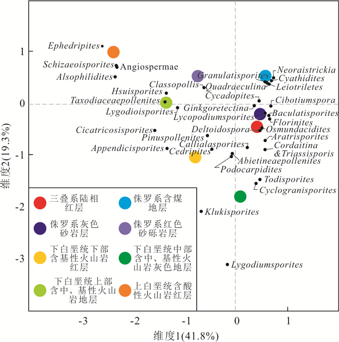
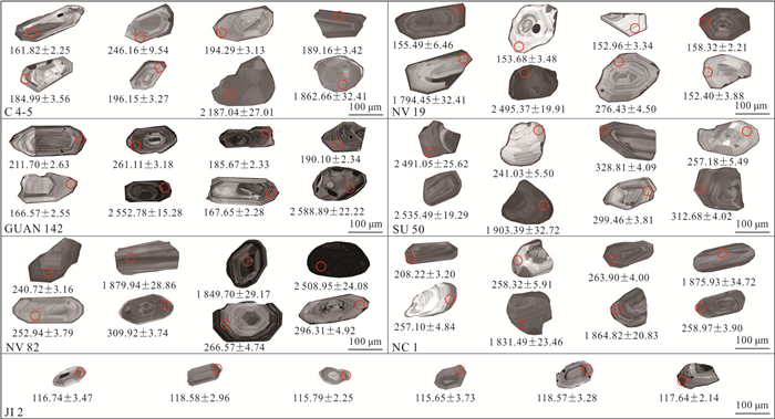
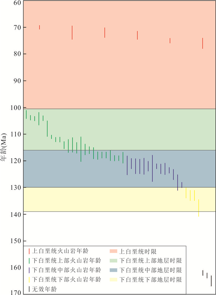
The Mesozoic in the Bohai Bay basin lacks unified stratigraphic framework. Based on logging data, sporopollen assemblage and age analysis of clastic and volcanic rocks, the stratigraphic subdivision and correlation of the Mesozoic were studied. The Mesozoic strata can be divided into eight stratigraphic units. The Triassic continental red strata develops the Aratrisporites⁃Triassisporis⁃Chordasporites assemblage, and the maximum depositional ages range from (241.4±6.8) Ma to (248.2±1.9) Ma. The Cyathidites⁃Osmundacidites⁃Cycadopites⁃Classopollis assemblage forms in the Jurassic coal-bearing strata, and the maximum depositional ages of the strata are from (173.4±1.1) Ma to (187.2±4.8) Ma. For the Jurassic gray sandstone strata, the maximum depositional ages range from (155.3±1.3) Ma to (164.4±3.8) Ma and the Cyathidites⁃Osmundacidites⁃Deltoidospora⁃Cycadopites assemblage are developed. The Jurassic red sandstone and gravel strata develop the Classopollis⁃Abietineaepollenites assemblage. In early stage of early Cretaceous, the red clastic strata with basic volcanic rock and the Cicatricosisporites⁃Lygodiumsporites⁃Classopollis assemblage formed. The volcanic rocks ages are from 140 to 132 Ma. For the gray clastic strata with intermediate-basic volcanic rock in the middle part of the lower Cretaceous, the Lygodiumsporites⁃Cicatricosisporites⁃Osmundacidites⁃Cycadopites assemblage and the volcanic rocks of the ages from 130 to 116 Ma are developed. The clastic strata with intermediate-basic volcanic rock in the upper part of the lower Cretaceous develop the assemblage of Cicatricosisporites⁃Schizaeoisporites⁃classopollis⁃Piceites, and the volcanic rocks ages range from 119 to 103 Ma. The Schizaeoisporites⁃Ephedripites⁃Classopollis assemblage forms in the Upper Cretaceous red clastic strata with acidic volcanic rock ranging from 76 to 69 Ma in age.
The Mesozoic in the Bohai Bay basin lacks unified stratigraphic framework. Based on logging data, sporopollen assemblage and age analysis of clastic and volcanic rocks, the stratigraphic subdivision and correlation of the Mesozoic were studied. The Mesozoic strata can be divided into eight stratigraphic units. The Triassic continental red strata develops the Aratrisporites⁃Triassisporis⁃Chordasporites assemblage, and the maximum depositional ages range from (241.4±6.8) Ma to (248.2±1.9) Ma. The Cyathidites⁃Osmundacidites⁃Cycadopites⁃Classopollis assemblage forms in the Jurassic coal-bearing strata, and the maximum depositional ages of the strata are from (173.4±1.1) Ma to (187.2±4.8) Ma. For the Jurassic gray sandstone strata, the maximum depositional ages range from (155.3±1.3) Ma to (164.4±3.8) Ma and the Cyathidites⁃Osmundacidites⁃Deltoidospora⁃Cycadopites assemblage are developed. The Jurassic red sandstone and gravel strata develop the Classopollis⁃Abietineaepollenites assemblage. In early stage of early Cretaceous, the red clastic strata with basic volcanic rock and the Cicatricosisporites⁃Lygodiumsporites⁃Classopollis assemblage formed. The volcanic rocks ages are from 140 to 132 Ma. For the gray clastic strata with intermediate-basic volcanic rock in the middle part of the lower Cretaceous, the Lygodiumsporites⁃Cicatricosisporites⁃Osmundacidites⁃Cycadopites assemblage and the volcanic rocks of the ages from 130 to 116 Ma are developed. The clastic strata with intermediate-basic volcanic rock in the upper part of the lower Cretaceous develop the assemblage of Cicatricosisporites⁃Schizaeoisporites⁃classopollis⁃Piceites, and the volcanic rocks ages range from 119 to 103 Ma. The Schizaeoisporites⁃Ephedripites⁃Classopollis assemblage forms in the Upper Cretaceous red clastic strata with acidic volcanic rock ranging from 76 to 69 Ma in age.


2024, 49(3): 1144-1153.
doi: 10.3799/dqkx.2022.223
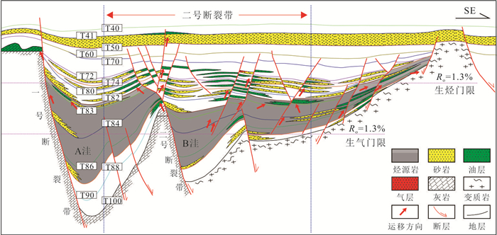
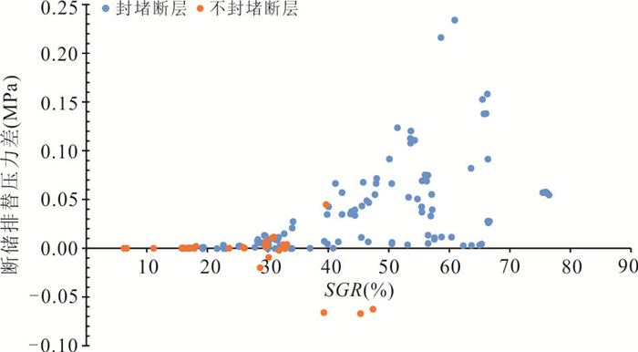
Abstract:
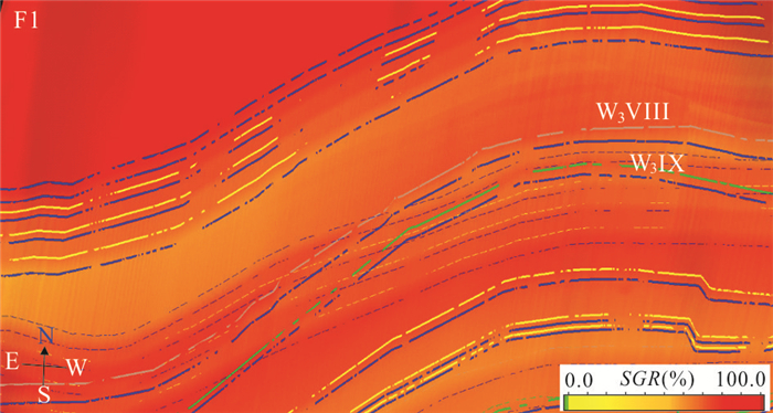
The evaluation of Fault sealing is divided into the evaluation of vertical sealing and the evaluation of lateral sealing. Previous studies mostly adopted the comprehensive fuzzy evaluation method to comprehensively evaluate the fault sealing performance. However, the evaluation results of the fuzzy comprehensive evaluation method are affected by the evaluation score and weight coefficient, which leads to the following two problems. Firstly, the evaluation score of each parameter of the traditional comprehensive evaluation method is obtained through the principle of maximum membership degree, ignoring the internal differences of the same kind of evaluation standards, resulting in low accuracy; secondly, the weight coefficient adopts empirical assignment or equivalent weight assignment, which is different from the actual regional geological environment. This study comprehensively considers the qualitative parameters such as fault mechanics background, lithology opposition relationship and fault reservoir configuration relationship, combined with the influence of quantitative parameters such as fault rock shale content, section normal pressure, fault reservoir displacement pressure and fault stress characteristics, so as to realize the quantitative score representation of the evaluation standard of quantitative parameters. Based on the statistical analysis of regional parameters, the weight coefficients of various parameters are determined and improved by analytic hierarchy process. The weight coefficient is more in line with the regional law. Block A of No.2 fault zone in Weixinan sag is selected as the target area for evaluation, and good results are obtained. Compared with previous research methods, the accuracy is significantly improved.
The evaluation of Fault sealing is divided into the evaluation of vertical sealing and the evaluation of lateral sealing. Previous studies mostly adopted the comprehensive fuzzy evaluation method to comprehensively evaluate the fault sealing performance. However, the evaluation results of the fuzzy comprehensive evaluation method are affected by the evaluation score and weight coefficient, which leads to the following two problems. Firstly, the evaluation score of each parameter of the traditional comprehensive evaluation method is obtained through the principle of maximum membership degree, ignoring the internal differences of the same kind of evaluation standards, resulting in low accuracy; secondly, the weight coefficient adopts empirical assignment or equivalent weight assignment, which is different from the actual regional geological environment. This study comprehensively considers the qualitative parameters such as fault mechanics background, lithology opposition relationship and fault reservoir configuration relationship, combined with the influence of quantitative parameters such as fault rock shale content, section normal pressure, fault reservoir displacement pressure and fault stress characteristics, so as to realize the quantitative score representation of the evaluation standard of quantitative parameters. Based on the statistical analysis of regional parameters, the weight coefficients of various parameters are determined and improved by analytic hierarchy process. The weight coefficient is more in line with the regional law. Block A of No.2 fault zone in Weixinan sag is selected as the target area for evaluation, and good results are obtained. Compared with previous research methods, the accuracy is significantly improved.


2024, 49(3): 1154-1164.
doi: 10.3799/dqkx.2022.427
Abstract:
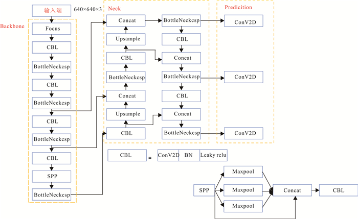
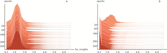
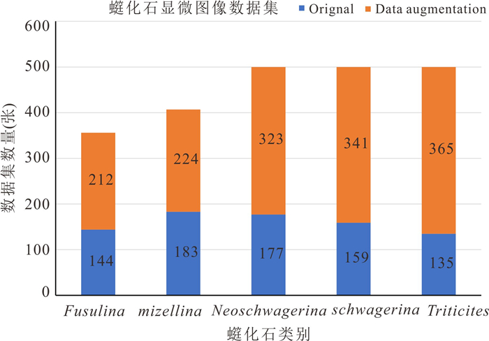
Fusulinids are important standard fossils of the Carboniferous and Permian periods. The identification of fusulinids is significant for determining the geological age and delineating the Carboniferous-Permian stratigraphy. Considering the limitations of current fossil detection methods, a fusulinid detection method based on a deep learning single-stage algorithm is proposed. Taking fusulinids as the research object, the original model is improved by channel pruning by jointly optimizing the weight loss function and L1 regularization of the BN layer scale factor to compress the model size. Furthermore, the knowledge distillation is utilized to restore the detection performance of the pruned model. The experimental results show that the method can achieve the classification and localization of the fusulinids in the thin section images. The average accuracy reaches 98.1%, which meets the requirements of the real-time detection model. In addition, the number of model parameters is reduced by 74.1%, which solves the problems such as the lack of arithmetic power existing in real scenes. The method can effectively achieve the detection of fusulinids, while extending the applicability of the model to embedded devices and providing more possibilities for deep learning to perform intelligent recognition in paleontological fossil images.
Fusulinids are important standard fossils of the Carboniferous and Permian periods. The identification of fusulinids is significant for determining the geological age and delineating the Carboniferous-Permian stratigraphy. Considering the limitations of current fossil detection methods, a fusulinid detection method based on a deep learning single-stage algorithm is proposed. Taking fusulinids as the research object, the original model is improved by channel pruning by jointly optimizing the weight loss function and L1 regularization of the BN layer scale factor to compress the model size. Furthermore, the knowledge distillation is utilized to restore the detection performance of the pruned model. The experimental results show that the method can achieve the classification and localization of the fusulinids in the thin section images. The average accuracy reaches 98.1%, which meets the requirements of the real-time detection model. In addition, the number of model parameters is reduced by 74.1%, which solves the problems such as the lack of arithmetic power existing in real scenes. The method can effectively achieve the detection of fusulinids, while extending the applicability of the model to embedded devices and providing more possibilities for deep learning to perform intelligent recognition in paleontological fossil images.


2024, 49(3): 1165-1176.
doi: 10.3799/dqkx.2022.433
Abstract:
Establishing a 3D orebody model is the foundation of digital mine and smart mine. In response to the phenomenon that the classical radial basis function surface reconstruction algorithm leads to surface boundary self-fitting and model discontinuity when the original data is sparse, this paper proposes a method of implicit automatic modeling of complex orebody with radial basis function incorporating multiple machine learning. This method uses the Stacking model to learn the distribution characteristics of the discrete point cloud data of the orebody contour lines to build a directed point set characterizing the geometric information of the orebody model. On this basis, the boundary points and normal vectors are extracted, the implicit field is established by the Hermite radial basis function, and finally the 3D orebody model is visualized based on the marching tetrahedron algorithm. The analysis was compared with the contour line splicing method, the classical radial basis function surface reconstruction algorithm, and the simple kriging interpolation method. The method can effectively reduce the phenomenon of self-fitting of surface boundaries, reduce redundant holes in the model, and improve the continuity of the model; the similarity between the contour lines cut by the established model and the original contour lines reaches 75.14%, which is comparable to the explicit model with a high degree of manual intervention; the gap between the model and the explicit model in volume characterization reaches the lowest.
Establishing a 3D orebody model is the foundation of digital mine and smart mine. In response to the phenomenon that the classical radial basis function surface reconstruction algorithm leads to surface boundary self-fitting and model discontinuity when the original data is sparse, this paper proposes a method of implicit automatic modeling of complex orebody with radial basis function incorporating multiple machine learning. This method uses the Stacking model to learn the distribution characteristics of the discrete point cloud data of the orebody contour lines to build a directed point set characterizing the geometric information of the orebody model. On this basis, the boundary points and normal vectors are extracted, the implicit field is established by the Hermite radial basis function, and finally the 3D orebody model is visualized based on the marching tetrahedron algorithm. The analysis was compared with the contour line splicing method, the classical radial basis function surface reconstruction algorithm, and the simple kriging interpolation method. The method can effectively reduce the phenomenon of self-fitting of surface boundaries, reduce redundant holes in the model, and improve the continuity of the model; the similarity between the contour lines cut by the established model and the original contour lines reaches 75.14%, which is comparable to the explicit model with a high degree of manual intervention; the gap between the model and the explicit model in volume characterization reaches the lowest.

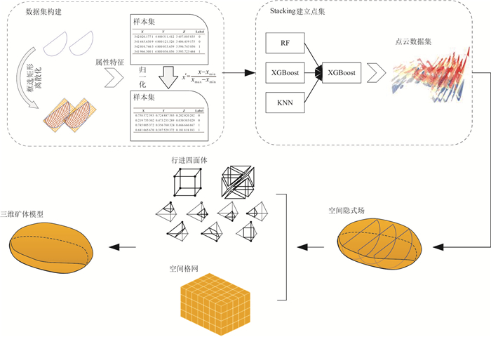
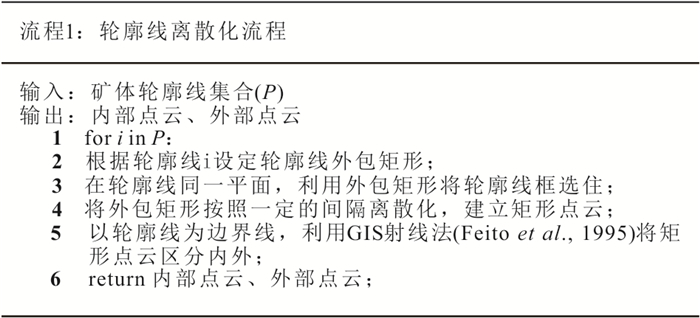


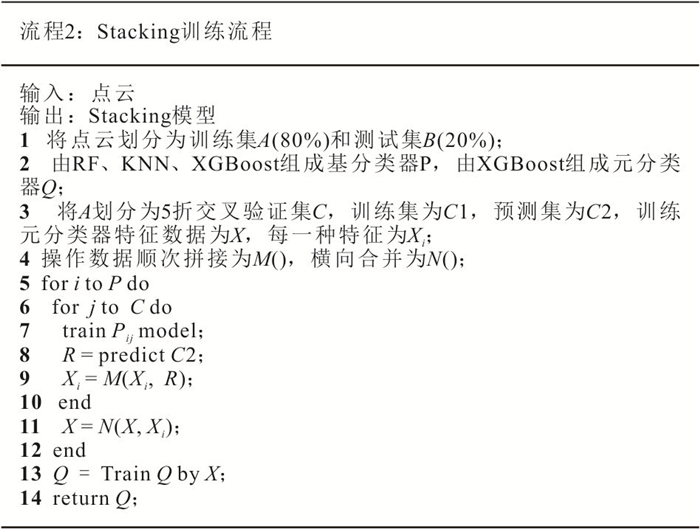
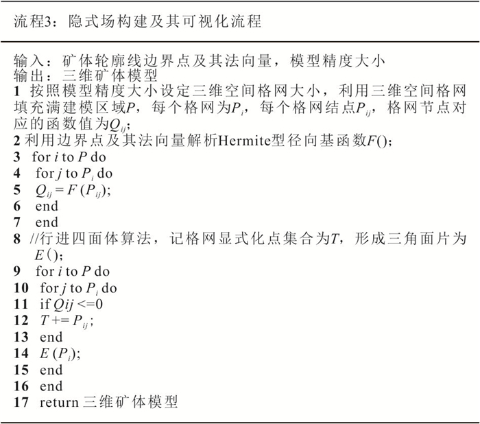
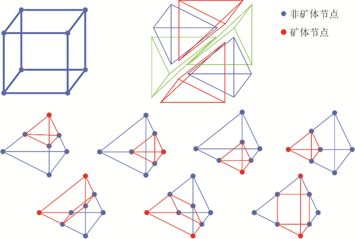


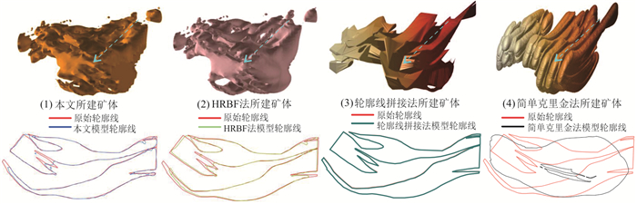

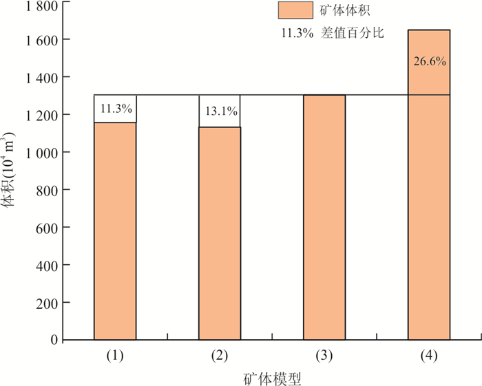
2024, 49(3): 1177-1188.
doi: 10.3799/dqkx.2022.204
Abstract:
Soil carbon storage in alpine regions is an important component of the global frost carbon pool. Lateral carbon export from terrestrial ecosystems to rivers in dissolved phase is an important pathway for soil carbon export from alpine catchments. Previous studies on dissolved carbon export from alpine catchments have focused on permafrost areas, and less attention has been paid to seasonal frost areas. To explore the patterns, influencing factors and mechanisms of dissolved carbon export through rivers in seasonal frost areas, we selected the Hongnigou catchment at the northern flank of the Qilian Mountains on the Qinghai-Xizang Plateau as the study area, and we made continuous observations of dissolved organic carbon (DOC) and dissolved inorganic carbon (DIC) concentrations and fluxes in river water. Combining the observed data of stable isotope abundance in river water and meteorology, hydrology, and ground temperature in the catchment, it is found that: (1) during the early thawing period in late spring, the riverine DOC and DIC at the outlet of the catchment were high in concentration but low in flux; (2) during the late thawing period in summer, the riverine DOC and DIC were low in concentration but high in flux; and (3) both DOC and DIC concentrations in the river showed an overall decreasing trend in summer, but slightly increased during low flow periods compared to high flow periods. The study shows that for the alpine catchments underlaid by seasonal frost, represented by the Hongnigou catchment, the dissolved carbon export is mainly influenced by frost characteristics and dynamics during the early thawing period. However, during the late thawing period in summer, it becomes dominated by hydrological input characteristics. During this period, the thin aquifers consisting mainly of fine-grained residual deposits and the widespread freeze-thaw disturbed landforms also have significant impacts, resulting in a higher riverine DOC concentration than that reported in other areas of the Qinghai-Xizang Plateau.
Soil carbon storage in alpine regions is an important component of the global frost carbon pool. Lateral carbon export from terrestrial ecosystems to rivers in dissolved phase is an important pathway for soil carbon export from alpine catchments. Previous studies on dissolved carbon export from alpine catchments have focused on permafrost areas, and less attention has been paid to seasonal frost areas. To explore the patterns, influencing factors and mechanisms of dissolved carbon export through rivers in seasonal frost areas, we selected the Hongnigou catchment at the northern flank of the Qilian Mountains on the Qinghai-Xizang Plateau as the study area, and we made continuous observations of dissolved organic carbon (DOC) and dissolved inorganic carbon (DIC) concentrations and fluxes in river water. Combining the observed data of stable isotope abundance in river water and meteorology, hydrology, and ground temperature in the catchment, it is found that: (1) during the early thawing period in late spring, the riverine DOC and DIC at the outlet of the catchment were high in concentration but low in flux; (2) during the late thawing period in summer, the riverine DOC and DIC were low in concentration but high in flux; and (3) both DOC and DIC concentrations in the river showed an overall decreasing trend in summer, but slightly increased during low flow periods compared to high flow periods. The study shows that for the alpine catchments underlaid by seasonal frost, represented by the Hongnigou catchment, the dissolved carbon export is mainly influenced by frost characteristics and dynamics during the early thawing period. However, during the late thawing period in summer, it becomes dominated by hydrological input characteristics. During this period, the thin aquifers consisting mainly of fine-grained residual deposits and the widespread freeze-thaw disturbed landforms also have significant impacts, resulting in a higher riverine DOC concentration than that reported in other areas of the Qinghai-Xizang Plateau.