- 中文版:
- EI 100%收录
- 英文版
- SCI 100%收录


中国出版政府奖提名奖
中国百强科技报刊
湖北出版政府奖
中国高校百佳科技期刊
中国最美期刊
中国出版政府奖提名奖
中国百强科技报刊
湖北出版政府奖
中国高校百佳科技期刊
中国最美期刊
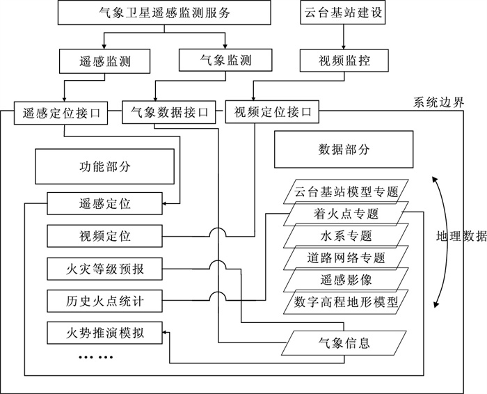
| Citation: | FAN Wen-you, MENG Xin, LIU Xiao-Jing, 2010. Design and Realization of Forest Fire Fighting Monitoring and Warning System Based on MapGIS. Earth Science, 35(3): 501-506. doi: 10.3799/dqkx.2010.064

|

|
Gu, T.Y., Gu, Y.F., 2009. The forest fire prevention command system in Yongji town based on GIS. Jilin Forestry Science & Technology, 38(2): 52-53 (in Chinese with English abstract).
|
|
Sun, X.X., Qi, T.J., Chen, B.L., 2008. Study on GIS-based digital monitoring system for fighting forest fire. Journal of Zhejiang for Sci. & Tech. , 28(4): 73-75 (in Chinese with English abstract). http://qikan.cqvip.com/Qikan/Article/Detail?id=28145426
|
|
Wang, Z.F., 1992. Current forest fire danger rating system. Journal of Nature Disasters, 1(3): 39-41 (in Chinese with English abstract). http://www.iafss.org/publications/aofst/1/121
|
|
Wu, X.C., 1998. Basic technology and development of geographic information system. Earth Science—Journal of China University of Geosciences, 23(4): 329-333 (in Chinese with English abstract). http://www.en.cnki.com.cn/Article_en/CJFDTOTAL-DQKX804.001.htm
|
|
Wu, X.C., Wu, L., 2006. Service-oriented distributed spatial information supporting system. Earth Science—Journal of China University of Geosciences, 31(5): 585-589 (in Chinese with English abstract). http://en.cnki.com.cn/Article_en/CJFDTOTAL-DQKX200605001.htm
|
|
Ye, Y.Q., Zuo, Z.J., Chen, B., 2006. Orient-entity spatial data model. Earth Science—Journal of China University of Geosciences, 31(5): 595-599 (in Chinese with English abstract).
|
|
Zhang, M.C., Deng, X.Y., Peng, Y.F., et al., 2001. Initial study on forest fire risk forecast of Pingxiang city. Jiangxi Meteorology Science & Technology, 24(1): 42-45 (in Chinese with English abstract). http://en.cnki.com.cn/Article_en/CJFDTOTAL-HXQO200101011.htm
|
|
Zhang, X.F., Zou, C.H., Chen, H.L., et al., 2006. Designing of forest fire disaster preventing system based on remote sensing and GIS techniques in Henan Province. Meteorological Science and Technology, 34(1): 107-111 (in Chinese with English abstract). http://en.cnki.com.cn/Article_en/CJFDTotal-QXKJ200601024.htm
|
|
顾彤宇, 顾彦方, 2009. 基于GIS的永吉县森林防火指挥系统的设计. 吉林林业科技, 38(2): 52-53. doi: 10.3969/j.issn.1005-7129.2009.02.018
|
|
孙欣欣, 齐同军, 陈白磊, 2008. 基于GIS林区防火数字化监控系统设计研究. 浙江林业科技, 28(4): 73-75. doi: 10.3969/j.issn.1001-3776.2008.04.017
|
|
王正非, 1992. 通用森林火险级系统. 自然灾害学报, 1(3): 39-41. https://www.cnki.com.cn/Article/CJFDTOTAL-ZRZH199203006.htm
|
|
吴信才, 1998. 地理信息系统的基本技术与发展动态. 地球科学——中国地质大学学报, 23(4): 329-333. https://www.cnki.com.cn/Article/CJFDTOTAL-CXYY201933059.htm
|
|
吴信才, 吴亮, 2006. 面向服务的分布式空间信息支撑平台. 地球科学——中国地质大学学报, 31(5): 585-589. https://www.cnki.com.cn/Article/CJFDTOTAL-DQKX200605001.htm
|
|
叶亚琴, 左泽均, 陈波, 2006. 面向实体的空间数据模型. 地球科学——中国地质大学学报, 31(5): 595-599. https://www.cnki.com.cn/Article/CJFDTOTAL-DQKX200605003.htm
|
|
张明初, 邓学友, 彭义峰, 等, 2001. 萍乡市森林火险(火灾)预报方法初探. 江西气象科技, 24(1): 42-45. https://www.cnki.com.cn/Article/CJFDTOTAL-HXQO200101011.htm
|
|
张雪芬, 邹春辉, 陈怀亮, 等, 2006. 基于遥感和地理信息系统的河南省森林防火系统. 气象科技, 34(1): 107-111. doi: 10.3969/j.issn.1671-6345.2006.01.021
|
Figures(4)


 DownLoad: