- 中文版:
- EI 100%收录
- 英文版
- SCI 100%收录


中国出版政府奖提名奖
中国百强科技报刊
湖北出版政府奖
中国高校百佳科技期刊
中国最美期刊
中国出版政府奖提名奖
中国百强科技报刊
湖北出版政府奖
中国高校百佳科技期刊
中国最美期刊
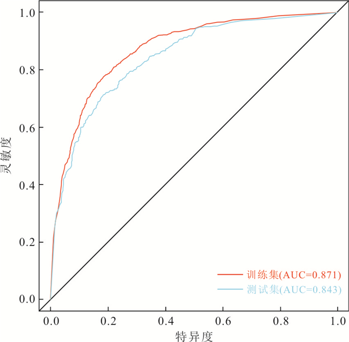
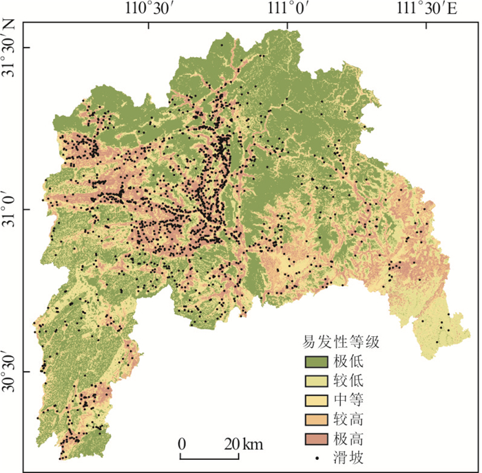
| Citation: | Wu Runze, Hu Xudong, Mei Hongbo, He Jinyong, Yang Jianying, 2021. Spatial Susceptibility Assessment of Landslides Based on Random Forest: A Case Study from Hubei Section in the Three Gorges Reservoir Area. Earth Science, 46(1): 321-330. doi: 10.3799/dqkx.2020.032

|

|
Aditian, A., Kubota, T., Shinohara, Y., 2018. Comparison of GIS-Based Landslide Susceptibility Models Using Frequency Ratio, Logistic Regression, and Artificial Neural Network in a Tertiary Region of Ambon, Indonesia. Geomorphology, 318:101-111. https://doi.org/10.1016/j.geomorph.2018.06.006
|
|
Alcántara-Ayala, I., 2002. Geomorphology, Natural Hazards, Vulnerability and Prevention of Natural Disasters in Developing Countries. Geomorphology, 47(2/3/4):107-124. https://doi.org/10.1016/s0169-555x(02)00083-1
|
|
Bennett, G. L., Miller, S. R., Roering, J. J., et al., 2016. Landslides, Threshold Slopes, and the Survival of Relict Terrain in the Wake of the Mendocino Triple Junction. Geology, 44(5):363-366. https://doi.org/10.1130/g37530.1
|
|
Breiman, L., Friedman, J. H., Olshen, R. A., et al., 1984. Classification and Regression Trees. Chapman & Hall, New York.
|
|
Breiman, L., 2001. Random Forests. Machine Learning, 45(1):5-32. https://doi.org/10.1023/A:1010933404324.
|
|
Feng, H.J., Zhou, A.G., Yu, J.J., et al., 2016. A Comparative Study on Plum-Rain-Triggered Landslide Susceptibility Assessment Models in West Zhejiang Province. Earth Science, 41(3):403-415 (in Chinese with English abstract). http://en.cnki.com.cn/Article_en/CJFDTOTAL-DQKX201603006.htm
|
|
Felicísimo, Á. M., Cuartero, A., Remondo, J., et al., 2013. Mapping Landslide Susceptibility with Logistic Regression, Multiple Adaptive Regression Splines, Classification and Regression Trees, and Maximum Entropy Methods:A Comparative Study. Landslides, 10(2):175-189. https://doi.org/10.1007/s10346-012-0320-1
|
|
Fenti, V., Silvano, S., Spagna, V., 1979. Methodological Proposal for an Engineering Geomorphological Map. Forecasting Rockfalls in the Alps. Bulletin of the International Association of Engineering Geology, 19(1):134-138. https://doi.org/10.1007/bf02600465
|
|
Guo, H.J., Tang, N.Q., Lin, J.B., 2010. Sensibility Analysis of Land-Use and Landslide Hazard Based on GIS in Xianyou County. Journal of Fujian Agriculture and Forestry University (Natural Science Edition), 39(4):417-420 (in Chinese with English abstract). http://www.cabdirect.org/abstracts/20103284954.html;jsessionid=4FA7BBD33F5E271F97960BEF557B26B0
|
|
Guo, Z.Z., Yin, K.L., Fu, S., et al., 2018. Evaluation of Landslide Susceptibility Based on GIS and WOE-BP Model. Earth Science, 44(12):4299-4312 (in Chinese with English abstract). http://www.researchgate.net/publication/324390254_Evaluation_of_Landslide_Susceptibility_Based_on_GIS_and_WOE-BP_Model
|
|
Guo, Z.Z., Yin, K.L., Liu, Q.L., et al., 2019. Rainfall Warning of Creeping Landslide in Yunyang County of Three Gorges Reservoir Region Based on Displacement Ratio Model. Earth Science, 45(2):672-684 (in Chinese with English abstract).
|
|
Jiang, R., 2010. Research on Generation Mechanism and Service of Slope Disaster Warning Information in Kunming City(Dissertation). Kunming University of Science and Technology, Kunming (in Chinese with English abstract).
|
|
Kornejady, A., Ownegh, M., Bahremand, A., 2017. Landslide Susceptibility Assessment Using Maximum Entropy Model with Two Different Data Sampling Methods. CATENA, 152:144-162. https://doi.org/10.1016/j.catena.2017.01.010
|
|
Li, S.L., Xu, Q., Tang, M.G., et al., 2018. Study on Spatial Distribution and Key Influencing Factors of Landslides in Three Gorges Reservoir Area. Earth Science, 45(1):341-354 (in Chinese with English abstract).
|
|
Li, Y.Y., Mei, H.B., Ren, X.J., et al., 2018.Geological Disaster Susceptibility Evaluation Based on Certainty Factor and Support Vector Machine. Journal of Geo-Information Science, 20(12):1699-1709 (in Chinese with English abstract). http://en.cnki.com.cn/Article_en/CJFDTotal-DQXX201812003.htm
|
|
Liu, L.N., Xu, C., Xu, X.W., et al., 2014. GIS-Based Landslide Hazard Evaluation Using AHP Method in the 2013 Lushan Earthquake Region. Journal of Catastrophology, 29(4):183-191 (in Chinese with English abstract). http://en.cnki.com.cn/Article_en/CJFDTotal-ZHXU201404037.htm
|
|
Nie, J., Lian, J., Hu, Z.W., 2014. Spatial Variation of Landslides in Wenchuan Earthquake-Stricken Areas. Geographical Research, 33 (2):214-224 (in Chinese with English abstract). http://en.cnki.com.cn/Article_en/CJFDTOTAL-DLYJ201402003.htm
|
|
Shi, X.G., Xu, J.H., Jiang, H.J., et al., 2019. Slope Stability State Monitoring and Updating of the Outang Landslide, Three Gorges Area with Time Series InSAR Analysis. Earth Science, 44(12):4284-4292 (in Chinese with English abstract). http://en.cnki.com.cn/Article_en/CJFDTotal-DQKX201912038.htm
|
|
Pham, B. T., Pradhan, B., Tien Bui, D., et al., 2016. A Comparative Study of Different Machine Learning Methods for Landslide Susceptibility Assessment:A Case Study of Uttarakhand Area (India). Environmental Modelling & Software, 84:240-250. https://doi.org/10.1016/j.envsoft.2016.07.005
|
|
Song, Y. Q., Gong, J. H., Gao, S., et al., 2012. Susceptibility Assessment of Earthquake-Induced Landslides Using Bayesian Network:A Case Study in Beichuan, China. Computers & Geosciences, 42:189-199. https://doi.org/10.1016/j.cageo.2011.09.011
|
|
Tehrany, M. S., Pradhan, B., Jebur, M. N., 2013. Spatial Prediction of Flood Susceptible Areas Using Rule Based Decision Tree (DT) and a Novel Ensemble Bivariate and Multivariate Statistical Models in GIS. Journal of Hydrology, 504:69-79. https://doi.org/10.1016/j.jhydrol.2013.09.034
|
|
Wang, L.L., 2016. Feature Processing Method in Rainfall-induced Landslide Susceptibility Assessment (Dissertation). Zhejiang University, Hangzhou (in Chinese with English abstract).
|
|
Wu, S., Li, L.W., Li, S.J., 2012. Analysis on the Influence of Coupling Relationship between Rock Mass Structural Plane and Water on Slope Stability. Journal of Jingchu University of Technology, 27(2):33-36 (in Chinese with English abstract).
|
|
Wu, X.L., Shen, S.Q., Niu, R.Q., 2016. Landslide Susceptibility Prediction Using GIS and PSO-SVM. Geomatics and Information Science of Wuhan University, 41(5):665-671 (in Chinese with English abstract). http://en.cnki.com.cn/Article_en/CJFDTotal-WHCH201605015.htm
|
|
Xiang, L.Z., Cui, P., 2014. Triggering Factors Susceptibility of Earthquake-Induced Collapses and Landslides in Wenchuan County. Journal of Sichuan University (Engineering Science Edition), 42(5):105-112 (in Chinese with English abstract). http://www.researchgate.net/publication/289748349_Triggering_factors_susceptibility_of_earthquake-induced_collapses_and_landslides_in_Wenchuan_County
|
|
Xiao T., 2007. GIS-Based Research on Spatial Simulation of Landslide in Lanzhou City (Dissertation). Lanzhou University, Lanzhou (in Chinese with English abstract).
|
|
Zare, M., Pourghasemi, H. R., Vafakhah, M., et al., 2013. Landslide Susceptibility Mapping at Vaz Watershed (Iran) Using an Artificial Neural Network Model:A Comparison between Multilayer Perceptron (MLP) and Radial Basic Function (RBF) Algorithms. Arabian Journal of Geosciences, 6(8):2873-2888. https://doi.org/10.1007/s12517-012-0610-x
|
|
冯杭建, 周爱国, 俞剑君, 等, 2016.浙西梅雨滑坡易发性评价模型对比.地球科学, 41(3):403-415. doi: 10.3799/dqkx.2016.032
|
|
郭慧娟, 唐南奇, 林金宝, 2010.基于GIS的仙游县土地利用与滑坡灾害敏感性分析.福建农林大学学报(自然科学版), 39(4):417-420. https://www.cnki.com.cn/Article/CJFDTOTAL-FJND201004018.htm
|
|
郭子正, 殷坤龙, 付圣, 等, 2018.基于GIS与WOE-BP模型的滑坡易发性评价.地球科学, 44(12):4299-4312. doi: 10.3799/dqkx.2016.032
|
|
郭子正, 殷坤龙, 刘庆丽, 等, 2019.基于位移比模型的三峡库区云阳县域内蠕变型滑坡降雨预警.地球科学45(2):672-684. doi: 10.3799/dqkx.2019.005
|
|
蒋锐, 2010.昆明市斜坡灾害预警信息生成机理及服务研究(博士学位论文).昆明: 昆明理工大学.
|
|
李松林, 许强, 汤明高, 等, 2018.三峡库区滑坡空间发育规律及其关键影响因子.地球科学, 45(1):341-354. doi: 10.3799/dqkx.2017.576
|
|
李远远, 梅红波, 任晓杰, 等, 2018.基于确定性系数和支持向量机的地质灾害易发性评价.地球信息科学学报, 20(12):1699-1709. doi: 10.12082/dqxxkx.2018.180349
|
|
刘丽娜, 许冲, 徐锡伟, 等, 2014. GIS支持下基于AHP方法的2013年芦山地震区滑坡危险性评价.灾害学, 29(4):183-191. doi: 10.3969/j.issn.1000-811X.2014.04.034
|
|
聂娟, 连健, 胡卓玮, 2014.汶川地震灾区滑坡空间特征变化分析.地理研究, 33(2):214-224. https://www.cnki.com.cn/Article/CJFDTOTAL-DLYJ201402003.htm
|
|
史绪国, 徐金虎, 蒋厚军, 等, 2019.时序InSAR技术三峡库区藕塘滑坡稳定性监测与状态更新.地球科学, 44(12):4284-4292. doi: 10.3799/dqkx.2019.180
|
|
王丽丽, 2016.降雨型滑坡地质灾害易发性评价中的特征处理方法.杭州: 浙江大学.
|
|
武尚, 李利文, 李世佳, 2012.岩体结构面与水耦合关系对边坡稳定性的影响分析.荆楚理工学院学报, 27(2):33-36 doi: 10.3969/j.issn.1008-4657.2012.02.007
|
|
武雪玲, 沈少青, 牛瑞卿, 2016. GIS支持下应用PSO-SVM模型预测滑坡易发性.武汉大学学报(信息科学版), 41(5):665-671. https://www.cnki.com.cn/Article/CJFDTOTAL-WHCH201605015.htm
|
|
向灵芝, 崔鹏, 2014.汶川县地震诱发崩滑灾害影响因素的敏感性分析.四川大学学报(工程科学版), 42(5):105-112. https://www.cnki.com.cn/Article/CJFDTOTAL-SCLH201005016.htm
|
|
肖桐, 2007.基于GIS的兰州市滑坡空间模拟研究(硕士学位论文).兰州: 兰州大学.
|

Figures(4) / Tables(3)


 DownLoad: