- 中文版:
- EI 100%收录
- 英文版
- SCI 100%收录


中国出版政府奖提名奖
中国百强科技报刊
湖北出版政府奖
中国高校百佳科技期刊
中国最美期刊
中国出版政府奖提名奖
中国百强科技报刊
湖北出版政府奖
中国高校百佳科技期刊
中国最美期刊
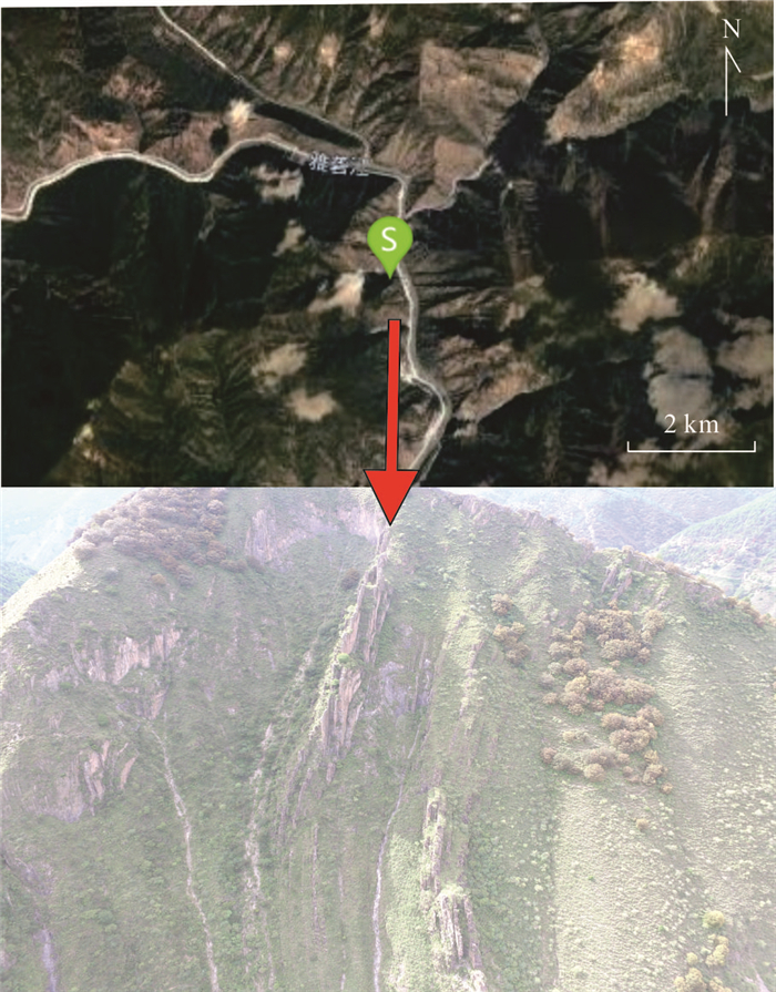
| Citation: | Cui Wei, Gao Deyu, Wang Xuanhao, Zhang Guike, Yang Hong, 2023. Identification of Rocky Ledge on Steep and High Slopes Based on Aerial Photogrammetry. Earth Science, 48(9): 3378-3388. doi: 10.3799/dqkx.2021.130

|

|
Bezdek, J. C., 1981. Pattern Recognition with Fuzzy Objective Function Algorithms. Springer, Boston. https://doi.org/10.1007/978-1-4757-0450-1
|
|
Durney, D. W., 2002. The Techniques of Modern Structural Geology, Volume 3: Applications of Continuum Mechanics in Structural Geology. Tectonophysics, 344(3-4): 307-310. https://doi.org/10.1016/s0040-1951(01)00270-0
|
|
Eker, R., Aydın, A., Hübl, J., 2018. Unmanned Aerial Vehicle (UAV)-Based Monitoring of a Landslide: Gallenzerkogel Landslide (Ybbs-Lower Austria) Case Study. Environmental Monitoring and Assessment, 190(1): 1-14. https://doi.org/10.1007/s10661-017-6402-8
|
|
Ester, M., Kriegel, H. P., Sander, J., et al., 1996. A Density-Based Algorithm for Discovering Clusters in Large Spatial Databases with Noise. The Second International Conference on Knowledge Discovery and Data Mining, Portland.
|
|
Greif, V., Vlcko, J., 2017. Kinematic Analysis of a Rock Slope at Strecno Castle (Slovakia) Based on the Processing of the Point Cloud Generated by UAV Photogrammetry. In: Mikos, M., Tiwari, B., Yin, Y., et al., eds., Advancing Culture of Living with Landslides. Springer, Cham.
|
|
Harwin, S., Lucieer, A., 2012. Assessing the Accuracy of Georeferenced Point Clouds Produced via Multi-View Stereopsis from Unmanned Aerial Vehicle (UAV) Imagery. Remote Sensing, 4(6): 1573-1599. https://doi.org/10.3390/rs4061573
|
|
Kaufman, L., Rousseeuw, P. J., 1990. Finding Groups in Data: An Introduction to Cluster Analysis. John Wiley, New York.
|
|
Kennedy, C., Hutchinson, D. J., Lato, M., 2014. Consideration of Lidar and Photogrammetric Data Analysis Resulting from Challenging Data Collection. The 48th U. S. Rock Mechanics/Geomechanics Symposium, Minnesota.
|
|
Kong, D. H., Wu, F. Q., Saroglou, C., 2020. Automatic Identification and Characterization of Discontinuities in Rock Masses from 3D Point Clouds. Engineering Geology, 265: 105442. https://doi.org/10.1016/j.enggeo.2019.105442
|
|
Li, H., Yu, Z. D., Cai, X. B., et al., 2017. River Terrace Extraction Based on Unmanned Aerial Vehicle Remote Sensing. Earth Science, 42(5): 734-742 (in Chinese with English abstract).
|
|
Lu, Z. E., Tian, Y. G., Liu, Q. W., et al., 2021. Topographical Linear Feature Extraction Method Based on Sentinel-1 and DEM in Areas with High Vegetation Coverage of Nanling. Earth Science, 46(4): 1349-1358 (in Chinese with English abstract).
|
|
Ma, H. C., 2011. Review on Applications of LiDAR Mapping Technology to Geosciences. Earth Science, 36(2): 347-354 (in Chinese with English abstract).
|
|
Macqueen, J. B., 1967. Some Methods for Classification and Analysis of Multivariate Observations. The 5th Berkeley Symposium on Mathematical Statistics and Probability, Berkeley.
|
|
Mora, C. F., Kwan, A. K. H., 2000. Sphericity, Shape Factor, and Convexity Measurement of Coarse Aggregate for Concrete Using Digital Image Processing. Cement and Concrete Research, 30(3): 351-358. https://doi.org/10.1016/S0008-8846(99)00259-8
|
|
Pauly, M., Gross, M., Kobbelt, L. P., 2002. Efficient Simplification of Point-Sampled Surface. IEEE Visualization 2002 Conference, Boston.
|
|
Qiu, J. L., Xia, Q. L., Yao, L. Q., et al., 2012. Mine Geological Modeling and Application Based on the Three-Dimensional Laser Scanner Technology. Earth Science, 37(6): 1209-1216 (in Chinese with English abstract).
|
|
Riquelme, A. J., Abellán, A., Tomás, R., et al., 2014. A New Approach for Semi-Automatic Rock Mass Joints Recognition from 3D Point Clouds. Computers & Geosciences, 68: 38-52. https://doi.org/10.1016/j.cageo.2014.03.014
|
|
Sabapathy, R., Sastry, V. R., Murthy, D. C. S. N., 2013. Mapping of Geological Discontinuity Using SIROVISION: A Case Study. National conference on "Present Technology and Safety Scenario in Mining & Allied Industries", Varanasi.
|
|
Shi, X. G., Xu, J. H., Jiang, H. J., et al., 2019. Slope Stability State Monitoring and Updating of the Outang Landslide, Three Gorges Area with Time Series InSAR Analysis. Earth Science, 44(12): 4284-4292 (in Chinese with English abstract).
|
|
Silverman, B. W., 1986. Density Estimation for Statistics and Data Analysis. Chapman and Hall, London.
|
|
Tonini, M., Abellan, A., 2014. Rockfall Detection from Terrestrial LiDAR Point Clouds: A Clustering Approach Using R. Journal of Spatial Information Science, (8): 95-110. https://doi.org/10.5311/josis.2014.8.123
|
|
Verhoeven, G., 2011. Taking Computer Vision Aloft: Archaeological Three-Dimensional Reconstructions from Aerial Photographs with Photoscan. Archaeological Prospection, 18(1): 67-73. https://doi.org/10.1002/arp.399
|
|
Wang, M., Li, L. H., Liao, X. H., et al., 2019. Rapid Topographic Measurement and Three-Dimensional Numerical Modeling Method for High-Steep/Upright Slopes Based on Aerial Photography of Uav. Journal of Engineering Geology, 27(5): 1000-1009 (in Chinese with English abstract).
|
|
Wang, S. Y., Tang, C., He, J., et al., 2016. Use of Unmanned Aerial Vehicle for Precise Investigation of Geological Hazard in Strong Seismic Zone. Journal of Engineering Geology, 24(4): 713-719 (in Chinese with English abstract).
|
|
Zhang, K., Wu, F. Q., Sha, P., et al., 2019. Geological Cataloging Method with Oblique Photography of Uav for Open-Pit Slope and Its Application. Journal of Engineering Geology, 27(6): 1448-1455 (in Chinese with English abstract).
|
|
Zhang, T. A., Ramakrishnan, R., Livny, M., 1996. Birch: An Efficient Data Clustering Method for Very Large. ACM SIGMOD Record, 25(2): 103-114. https://doi.org/10.1145/233269.233324
|
|
李辉, 余忠迪, 蔡晓斌, 等, 2017. 基于无人机遥感的河流阶地提取. 地球科学, 42(5): 734-742. doi: 10.3799/dqkx.2017.061
|
|
鲁泽恩, 田玉刚, 柳庆威, 等, 2021. 基于Sentinel-1和DEM数据的南岭高植被覆盖区地形线性特征提取方法. 地球科学, 46(4): 1349-1358. doi: 10.3799/dqkx.2020.351
|
|
马洪超, 2011. 激光雷达测量技术在地学中的若干应用. 地球科学, 36(2): 347-354. doi: 10.3799/dqkx.2011.037
|
|
邱俊玲, 夏庆霖, 姚凌青, 等, 2012. 基于三维激光扫描技术的矿山地质建模与应用. 地球科学, 37(6): 1209-1216. doi: 10.3799/dqkx.2012.129
|
|
史绪国, 徐金虎, 蒋厚军, 等, 2019. 时序InSAR技术三峡库区藕塘滑坡稳定性监测与状态更新. 地球科学, 44(12): 4284-4292. doi: 10.3799/dqkx.2019.180
|
|
王明, 李丽慧, 廖小辉, 等, 2019. 基于无人机航摄的高陡/直立边坡快速地形测量及三维数值建模方法. 工程地质学报, 27(5): 1000-1009. https://www.cnki.com.cn/Article/CJFDTOTAL-GCDZ201905008.htm
|
|
王帅永, 唐川, 何敬, 等, 2016. 无人机在强震区地质灾害精细调查中的应用研究. 工程地质学报, 24(4): 713-719. https://www.cnki.com.cn/Article/CJFDTOTAL-GCDZ201604033.htm
|
|
张恺, 伍法权, 沙鹏, 等, 2019. 基于无人机倾斜摄影的矿山边坡岩体结构编录方法与工程应用. 工程地质学报, 27(6): 1448-1455. https://www.cnki.com.cn/Article/CJFDTOTAL-GCDZ201906027.htm
|
Figures(15) / Tables(4)


 DownLoad: