- 中文版:
- EI 100%收录
- 英文版
- SCI 100%收录


中国出版政府奖提名奖
中国百强科技报刊
湖北出版政府奖
中国高校百佳科技期刊
中国最美期刊
中国出版政府奖提名奖
中国百强科技报刊
湖北出版政府奖
中国高校百佳科技期刊
中国最美期刊
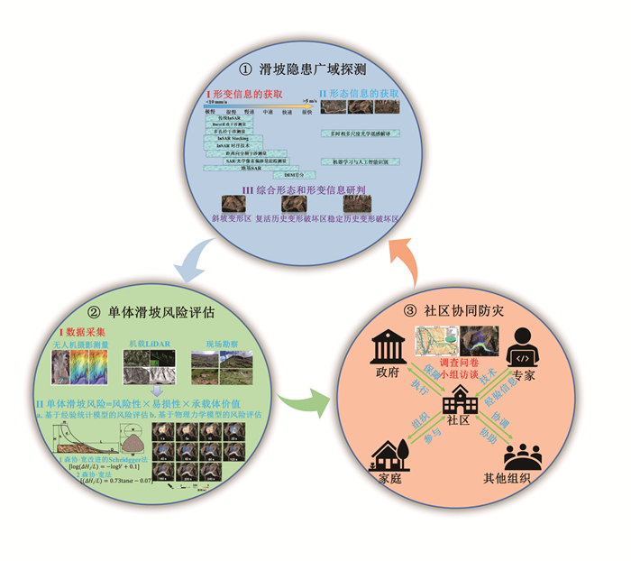
| Citation: | Li Zhenhong, Zhang Chenglong, Chen Bo, Zhan Jiewei, Ding Mingtao, Lü Yan, Li Xinlong, Peng Jianbing, 2022. A Technical Framework of Landslide Prevention Based on Multi-Source Remote Sensing and Its Engineering Application. Earth Science, 47(6): 1901-1916. doi: 10.3799/dqkx.2022.205

|

|
Amatya, P., Kirschbaum, D., Stanley, T., et al., 2021. Landslide Mapping Using Object-Based Image Analysis and Open Source Tools. Engineering Geology, 282: 106000. https://doi.org/10.1016/j.enggeo.2021.106000
|
|
Bechor, N. B. D., Zebker, H. A., 2006. Measuring Two-Dimensional Movements Using a Single InSAR Pair. Geophysical Research Letters, 33(16): L16311. https://doi.org/10.1029/2006gl026883
|
|
Behling, R., Roessner, S., Golovko, D., et al., 2016. Derivation of Long-Term Spatiotemporal Landslide Activity—A Multi-Sensor Time Series Approach. Remote Sensing of Environment, 186: 88-104. https://doi.org/10.1016/j.rse.2016.07.017
|
|
Berardino, P., Fornaro, G., Lanari, R., et al., 2002. A New Algorithm for Surface Deformation Monitoring Based on Small Baseline Differential SAR Interferograms. IEEE Transactions on Geoscience and Remote Sensing, 40(11): 2375-2383. https://doi.org/10.1109/tgrs.2002.803792
|
|
Casu, F., Manconi, A., Pepe, A., et al., 2011. Deformation Time-Series Generation in Areas Characterized by Large Displacement Dynamics: The SAR Amplitude Pixel-Offset SBAS Technique. IEEE Transactions on Geoscience and Remote Sensing, 49(7): 2752-2763. https://doi.org/10.1109/tgrs.2010.2104325
|
|
Chen, W. T., Li, X. J., Wang, Y. X., et al., 2014. Forested Landslide Detection Using LiDAR Data and the Random Forest Algorithm: A Case Study of the Three Gorges, China. Remote Sensing of Environment, 152: 291-301. https://doi.org/10.1016/j.rse.2014.07.004
|
|
Chowdhury, R., Flentje, P., 2003. Role of Slope Reliability Analysis in Landslide Risk Management. Bulletin of Engineering Geology and the Environment, 62(1): 41-46. https://doi.org/10.1007/s10064-002-0166-1
|
|
Comert, R., Avdan, U., Gorum, T., et al., 2019. Mapping of Shallow Landslides with Object-Based Image Analysis from Unmanned Aerial Vehicle Data. Engineering Geology, 260: 105264. https://doi.org/10.1016/j.enggeo.2019.105264
|
|
Cruden, D. M., Varnes, D. J., 1996. Landslide Types and Processes. Landslides: Investigation and Mitigation, 247: 36-75
|
|
Dai, K. R., Li, Z. H., Xu, Q., et al., 2020. Entering the Era of Earth Observation-Based Landslide Warning Systems: A Novel and Exciting Framework. IEEE Geoscience and Remote Sensing Magazine, 8(1): 136-153. https://doi.org/10.1109/mgrs.2019.2954395
|
|
Danneels, G., Pirard, E., Havenith, H. B., 2007. Automatic Landslide Detection from Remote Sensing Images Using Supervised Classification Methods. 2007 IEEE International Geoscience and Remote Sensing Symposium, Barcelona, Spain, 3014-3017. https://doi.org/10.1109/igarss.2007.4423479
|
|
Evans, S. G., 2006. The Formation and Failure of Landslide Dams: An Approach to Risk Assessment. Italian Journal of Engineering Geology and Environment, 1: 15-20
|
|
Ferretti, A., Prati, C., Rocca, F. L., 1999. Permanent Scatterers in SAR Interferometry. Remote Sensing. Proceedings Volume 3869, SAR Image Analysis, Modeling, and Techniques Ⅱ, Florence, Italy, 139-145. https://doi.org/10.1117/12.373150
|
|
Ferretti, A., Prati, C., Rocca, F., 2000. Nonlinear Subsidence Rate Estimation Using Permanent Scatterers in Differential SAR Interferometry. IEEE Transactions on Geoscience and Remote Sensing, 38(5): 2202-2212. https://doi.org/10.1109/36.868878
|
|
Ferretti, A., Prati, C., Rocca, F., 2001. Permanent Scatterers in SAR Interferometry. IEEE Transactions on Geoscience and Remote Sensing. 39(1): 8-20. https://doi.org/10.1109/36.898661
|
|
Ge, D. Q., Dai, K. R., Guo, Z. C., et al., 2019. Early Identification of Serious Geological Hazards with Integrated Remote Sensing Technologies: Thoughts and Recommendations. Geomatics and Information Science of Wuhan University, 44(7): 949-956(in Chinese with English abstract)
|
|
Ghorbanzadeh, O., Blaschke, T., Gholamnia, K., et al., 2019. Evaluation of Different Machine Learning Methods and Deep-Learning Convolutional Neural Networks for Landslide Detection. Remote Sensing, 11(2): 196. https://doi.org/10.3390/rs11020196
|
|
Gorsevski, P. V., Brown, M. K., Panter, K., et al., 2016. Landslide Detection and Susceptibility Mapping Using LiDAR and an Artificial Neural Network Approach: A Case Study in the Cuyahoga Valley National Park, Ohio. Landslides, 13(3): 467-484. https://doi.org/10.1007/s10346-015-0587-0
|
|
Grandin, R., Klein, E., Métois, M., et al., 2016. Three-Dimensional Displacement Field of the 2015 Mw8.3 Illapel Earthquake (Chile) from across- and along-Track Sentinel-1 TOPS Interferometry. Geophysical Research Letters, 43(6): 2552-2561. https://doi.org/10.1002/2016gl067954
|
|
Guo, C. B., Zhang, Y. S., Montgomery, D. R., et al., 2016. How Unusual is the Long-Runout of the Earthquake-Triggered Giant Luanshibao Landslide, Tibetan Plateau, China? Geomorphology, 259: 145-154. https://doi.org/10.1016/j.geomorph.2016.02.013
|
|
Hungr, O., 1995. A Model for the Runout Analysis of Rapid Flow Slides, Debris Flows, and Avalanches. Canadian Geotechnical Journal, 32(4): 610-623. https://doi.org/10.1139/t95-063
|
|
Hungr, O., Corominas, J., Eberhardt, E., 2005. Estimating Landslide Motion Mechanisms, Travel Distance and Velocity. Landslide Risk Management, London, 1: 109-138.
|
|
Hungr, O., Leroueil, S., Picarelli, L., 2014. The Varnes Classification of Landslide Types, an Update. Landslides, 11(2): 167-194. https://doi.org/10.1007/s10346-013-0436-y
|
|
Ji, S. P., Yu, D. W., Shen, C. Y., et al., 2020. Landslide Detection from an Open Satellite Imagery and Digital Elevation Model Dataset Using Attention Boosted Convolutional Neural Networks. Landslides, 17(6): 1337-1352. https://doi.org/10.1007/s10346-020-01353-2
|
|
Ju, Y. Z., Xu, Q., Jin, S. C., et al., 2022. Loess Landslide Detection Using Object Detection Algorithms in Northwest China. Remote Sensing, 14(5): 1182. https://doi.org/10.3390/rs14051182
|
|
Keyport, R. N., Oommen, T., Martha, T. R., et al., 2018. A Comparative Analysis of Pixel- and Object-Based Detection of Landslides from Very High-Resolution Images. International Journal of Applied Earth Observation and Geoinformation, 64: 1-11. https://doi.org/10.1016/j.jag.2017.08.015
|
|
Langhammer, L., Rabenstein, L., Schmid, L., et al., 2019. Glacier Bed Surveying with Helicopter-Borne Dual-Polarization Ground-Penetrating Radar. Journal of Glaciology, 65(249): 123-135. https://doi.org/10.1017/jog.2018.99
|
|
Lee, E. M., 2009. Landslide Risk Assessment: The Challenge of Estimating the Probability of Landsliding. Quarterly Journal of Engineering Geology and Hydrogeology, 42(4): 445-458. https://doi.org/10.1144/1470-9236/08-007
|
|
Leprince, S., Ayoub, F., Klinger, Y., et al., 2007. Co-Registration of Optically Sensed Images and Correlation (COSI-Corr): An Operational Methodology for Ground Deformation Measurements. 2007 IEEE International Geoscience and Remote Sensing Symposium. Barcelona, Spain, 1943-1946. https://doi.org/10.1109/igarss.2007.4423207
|
|
Li, S. H., Liu, T. P., Liu, X. Y., 2009. Analysis Method for Landslide Stability. Chinese Journal of Rock Mechanics and Engineering, 28(Suppl. 2): 3309-3324(in Chinese with English abstract)
|
|
Li, W. L., Xu, Q., Lu, H. Y., et al., 2019. Tracking the Deformation History of Large-Scale Rocky Landslides and Its Enlightenment. Geomatics and Information Science of Wuhan University, 44(7): 1043-1053(in Chinese with English abstract).
|
|
Li, Z. B., Shi, W. Z., Myint, S. W., et al., 2016. Semi-Automated Landslide Inventory Mapping from Bitemporal Aerial Photographs Using Change Detection and Level Set Method. Remote Sensing of Environment, 175: 215-230. https://doi.org/10.1016/j.rse.2016.01.003
|
|
Li, Z. H., 2005. Correction of Atmospheric Water Vapour Effects on Repeat-Pass SAR Interferometry Using GPS, MODIS and MERIS Data (Dissertation). University of London, London.
|
|
Li, Z. H., Fielding, E. J., Cross, P., 2009. Integration of InSAR Time-Series Analysis and Water-Vapor Correction for Mapping Postseismic Motion after the 2003 Bam (Iran) Earthquake. IEEE Transactions on Geoscience and Remote Sensing, 47(9): 3220-3230. https://doi.org/10.1109/tgrs.2009.2019125
|
|
Li, Z. H., Li, P., Ding, D., et al., 2018. Research Progress of Global High Resolution Digital Elevation Models. Geomatics and Information Science of Wuhan University, 43(12): 1927-1942(in Chinese with English abstract).
|
|
Li, Z. H., Song, C., Yu, C., et al., 2019. Application of Satellite Radar Remote Sensing to Landslide Detection and Monitoring: Challenges and Solutions. Geomatics and Information Science of Wuhan University, 44(7): 967-979(in Chinese with English abstract).
|
|
Lu, P., Qin, Y. Y., Li, Z. B., et al., 2019. Landslide Mapping from Multi-Sensor Data through Improved Change Detection-Based Markov Random Field. Remote Sensing of Environment, 231: 111235. https://doi.org/10.1016/j.rse.2019.111235
|
|
Lü, Z. Y., Shi, W. Z., Zhang, X. K., et al., 2018. Landslide Inventory Mapping from Bitemporal High-Resolution Remote Sensing Images Using Change Detection and Multiscale Segmentation. IEEE Journal of Selected Topics in Applied Earth Observations and Remote Sensing, 11(5): 1520-1532. https://doi.org/10.1109/jstars.2018.2803784
|
|
Luo, H. B., Li, Z. H., Chen, J. J., et al., 2019. Integration of Range Split Spectrum Interferometry and Conventional InSAR to Monitor Large Gradient Surface Displacements. International Journal of Applied Earth Observation and Geoinformation, 74: 130-137. https://doi.org/10.1016/j.jag.2018.09.004
|
|
Martha, T. R., Kerle, N., van Westen, C. J., et al., 2011. Segment Optimization and Data-Driven Thresholding for Knowledge-Based Landslide Detection by Object-Based Image Analysis. IEEE Transactions on Geoscience and Remote Sensing, 49(12): 4928-4943. https://doi.org/10.1109/tgrs.2011.2151866
|
|
Massonnet, D., Feigl, K. L., 1998. Radar Interferometry and Its Application to Changes in the Earth's Surface. Reviews of Geophysics, 36(4): 441-500. https://doi.org/10.1029/97rg03139
|
|
Moon, K., Blackman, D., 2014. A Guide to Understanding Social Science Research for Natural Scientists. Conservation Biology, 28(5): 1167-1177. https://doi.org/10.1111/cobi.12326
|
|
Morishita, Y., Lazecky, M., Wright, T., et al., 2020. LiCSBAS: An Open-Source InSAR Time Series Analysis Package Integrated with the LiCSAR Automated Sentinel-1 InSAR Processor. Remote Sensing, 12(3): 424. https://doi.org/10.3390/rs12030424
|
|
Othman, A., Gloaguen, R., 2013. Automatic Extraction and Size Distribution of Landslides in Kurdistan Region, NE Iraq. Remote Sensing, 5(5): 2389-2410. https://doi.org/10.3390/rs5052389
|
|
Oyasu, K., 2019. Community Based Learning for Sustainable Development. Kult-Ur Revista Interdisciplinària Sobre La Cultura De La Ciutat, 6(11): 39-62. https://doi.org/10.6035/kult-ur.2019.6.11.2
|
|
Rosen, P. A., Hensley, S., Joughin, I. R., et al., 2000. Synthetic Aperture Radar Interferometry. Proceedings of the IEEE, 88(3): 333-382. https://doi.org/10.1109/5.838084
|
|
Shi, W. Z., Zhang, M., Ke, H. F., et al., 2021. Landslide Recognition by Deep Convolutional Neural Network and Change Detection. IEEE Transactions on Geoscience and Remote Sensing, 59(6): 4654-4672. https://doi.org/10.1109/tgrs.2020.3015826
|
|
Shi, X. G., Zhang, L., Balz, T., et al., 2015. Landslide Deformation Monitoring Using Point-Like Target Offset Tracking with Multi-Mode High-Resolution TerraSAR-X Data. ISPRS Journal of Photogrammetry and Remote Sensing, 105: 128-140. https://doi.org/10.1016/j.isprsjprs.2015.03.017
|
|
Sim, T., Dominelli, L., Lau, J., 2017. A Pathway to Initiate Bottom-up Community-Based Disaster Risk Reduction within a Top-down System: The Case of China. International Journal of Safety and Security Engineering, 7(3): 283-293. https://doi.org/10.2495/safe-v7-n3-283-293
|
|
Singleton, A., Li, Z., Hoey, T., et al., 2014. Evaluating Sub-Pixel Offset Techniques as an Alternative to D-InSAR for Monitoring Episodic Landslide Movements in Vegetated Terrain. Remote Sensing of Environment, 147: 133-144. https://doi.org/10.1016/j.rse.2014.03.003
|
|
van den Eeckhaut, M., Kerle, N., Poesen, J., et al., 2012. Object-Oriented Identification of Forested Landslides with Derivatives of Single Pulse LiDAR Data. Geomorphology, 173-174: 30-42. https://doi.org/10.1016/j.geomorph.2012.05.024
|
|
Varnes, D. J., 1984. Landslide Hazard Zonation: A Review of Principles and Practice. UNESCO, Paris, 3.
|
|
Wang, N. Q., Zhang, Z. Y., Wang, J. D., 2003. A Forecasting Method of Sliding Distance on Typical Loess Landslides. Journal of Northwest University (Natural Science Edition), 33(1): 111-114(in Chinese with English abstract).
|
|
Wang, Z., Li, Z., Liu, Y., et al., 2019. A New Processing Chain for Real-Time Ground-Based SAR (RT-GBSAR) Deformation Monitoring. Remote Sensing, 11(20): 2437.
|
|
Wu, S. R., Shi, J. S., Zhang, C. S., et al., 2009. Preliminary Discussion on Technical Guideline for Geohazard Risk Assessment. Geological Bulletin of China, 28(8): 995-1005(in Chinese with English abstract).
|
|
Wu, Y., Liu, D. S., Lu, X., et al., 2011. Vulnerability Assessment Model for Hazard Bearing Body and Landslide Risk Index. Rock and Soil Mechanics, 32(8): 2487-2492, 2499(in Chinese with English abstract)
|
|
Wu, Z. F., 2009. The Study of Interpretation of Large-Scale Landslides and Hazard Assessment in Wulong County Based on RS and GIS (Dissertation). Southwest University, Chongqing(in Chinese with English abstract).
|
|
Xiao, R. Y., Yu, C., Li, Z. H., et al., 2020. General Survey of Large-Scale Land Subsidence by GACOS-Corrected InSAR Stacking: Case Study in North China Plain. Proceedings of the International Association of Hydrological Sciences, 382: 213-218. https://doi.org/10.5194/piahs-382-213-2020
|
|
Xiong, S. Q., 2009. The Strategic Consideration of the Development of China's Airborne Geophysical Technology. Geology in China, 36(6): 1366-1374(in Chinese with English abstract).
|
|
Xu, Q., Dong, X. J., Li, W. L., 2019. Integrated Space-Air-Ground Early Detection, Monitoring and Warning System for Potential Catastrophic Geohazards. Geomatics and Information Science of Wuhan University, 44(7): 957-966(in Chinese with English abstract).
|
|
Xu, W. Y., Zhang, Z. T., 1995. Study on Landslide Failure Probability and Reliability. Journal of Catastrophology, 10(4): 33-37(in Chinese with English abstract).
|
|
Yao, J. M., Lan, H. X., Li, L. P., et al., 2022. Characteristics of a Rapid Landsliding Area along Jinsha River Revealed by Multi-Temporal Remote Sensing and Its Risks to Sichuan-Tibet Traffic Corridor. Landslides, 19(3): 703-718. https://doi.org/10.1007/s10346-021-01790-7
|
|
Yu, C., Li, Z. H., Penna, N. T., 2018a. Interferometric Synthetic Aperture Radar Atmospheric Correction Using a GPS-Based Iterative Tropospheric Decomposition Model. Remote Sensing of Environment, 204: 109-121. https://doi.org/10.1016/j.rse.2017.10.038
|
|
Yu, C., Li, Z. H., Penna, N. T., et al., 2018b. Generic Atmospheric Correction Model for Interferometric Synthetic Aperture Radar Observations. Journal of Geophysical Research: Solid Earth, 123(10): 9202-9222. https://doi.org/10.1029/2017jb015305
|
|
Yu, C., Li, Z. H., Penna, N. T., 2020. Triggered Afterslip on the Southern Hikurangi Subduction Interface Following the 2016 Kaikōura Earthquake from InSAR Time Series with Atmospheric Corrections. Remote Sensing of Environment, 251: 112097. https://doi.org/10.1016/j.rse.2020.112097
|
|
Yu, C., Penna, N. T., Li, Z. H., 2017. Generation of Real-Time Mode High-Resolution Water Vapor Fields from GPS Observations. Journal of Geophysical Research: Atmospheres, 122(3): 2008-2025. https://doi.org/10.1002/2016jd025753
|
|
Zhong, C., Liu, Y., Gao, P., et al., 2020. Landslide Mapping with Remote Sensing: Challenges and Opportunities. International Journal of Remote Sensing, 41(4): 1555-1581. https://doi.org/10.1016/j.rse.2020.112097
|
|
Zhuang, J. Q., Peng, J. B., Wang, G. H., et al., 2018. Distribution and Characteristics of Landslide in Loess Plateau: A Case Study in Shaanxi Province. Engineering Geology, 236: 89-96. https://doi.org/10.1016/j.enggeo.2017.03.001
|
|
葛大庆, 戴可人, 郭兆成, 等, 2019. 重大地质灾害隐患早期识别中综合遥感应用的思考与建议. 武汉大学学报(信息科学版), 44(7): 949-956.
|
|
李世海, 刘天苹, 刘晓宇, 2009. 论滑坡稳定性分析方法. 岩石力学与工程学报, 28(增刊2): 3309-3324.
|
|
李为乐, 许强, 陆会燕, 等, 2019. 大型岩质滑坡形变历史回溯及其启示. 武汉大学学报(信息科学版), 44(7): 1043-1053.
|
|
李振洪, 李鹏, 丁咚, 等, 2018. 全球高分辨率数字高程模型研究进展与展望, 武汉大学学报(信息科学版), 43(12): 1927-1942.
|
|
李振洪, 宋闯, 余琛, 等, 2019. 卫星雷达遥感在滑坡灾害探测和监测中的应用: 挑战与对策. 武汉大学学报(信息科学版), 44(7): 967-979.
|
|
王念秦, 张倬元, 王家鼎, 2003. 一种典型黄土滑坡的滑距预测方法. 西北大学学报(自然科学版), 33(1): 111-114.
|
|
吴树仁, 石菊松, 张春山, 等, 2009. 地质灾害风险评估技术指南初论. 地质通报, 28(8): 995-1005.
|
|
吴越, 刘东升, 陆新, 等, 2011. 承灾体易损性评估模型与滑坡灾害风险度指标. 岩土力学, 32(8): 2487-2492, 2499.
|
|
吴忠芳, 2009. RS和GIS技术支持下的武隆县大型滑坡遥感解译及其危险性评价(硕士学位论文). 重庆: 西南大学.
|
|
熊盛青, 2009. 发展中国航空物探技术有关问题的思考. 中国地质, 36(6): 1366-1374.
|
|
许强, 2018. 构建新"三查"体系, 创新地灾防治新机制. http://www.zgkyb.com/yw/20180312_48669.htm
|
|
许强, 2020. 对地质灾害隐患早期识别相关问题的认识与思考. 武汉大学学报(信息科学版), 45(11): 1651-1659
|
|
许强, 董秀军, 李为乐, 2019. 基于天-空-地一体化的重大地质灾害隐患早期识别与监测预警. 武汉大学学报(信息科学版), 44(7): 957-966.
|
|
许强, 陆会燕, 李为乐, 等, 2022. 滑坡隐患类型与对应识别方法. 武汉大学学报(信息科学版), 47(3): 377-387.
|
|
徐卫亚, 张志腾, 1995. 滑坡失稳破坏概率及可靠度研究. 灾害学, (4): 33-37.
|
|
殷坤龙, 张宇, 汪洋, 2022. 水库滑坡涌浪风险研究现状和灾害链风险管控实践. 地质科技通报, 41(2): 1-12.
|
|
殷跃平, 2018. 全面提升地质灾害防灾减灾科技水平. 中国地质灾害与防治学报, 29(5): 3
|
|
张成龙, 李振洪, 余琛, 等, 2021. 利用GACOS辅助下InSAR Stacking对金沙江流域进行滑坡监测. 武汉大学学报(信息科学版), 46(11): 1649-1657.
|
|
张东明, 李剑锋, 田贵维, 等, 2011. 基于GIS和RS的重庆市滑坡遥感解译. 自然灾害学报, 20(2): 56-61.
|
Figures(5) / Tables(1)


 DownLoad: