- 中文版:
- EI 100%收录
- 英文版
- SCI 100%收录


中国出版政府奖提名奖
中国百强科技报刊
湖北出版政府奖
中国高校百佳科技期刊
中国最美期刊
中国出版政府奖提名奖
中国百强科技报刊
湖北出版政府奖
中国高校百佳科技期刊
中国最美期刊
| Citation: | Yuan Kai, Li Xing, Liu Ruifeng, Zhang Lianpeng, Zhang Qihua, Cao Zhaofeng, Wang Yunkai, 2024. Mapping Bare Rock in Open-Pit Limestone Mining Area Using Gaofen-2 Satellite Image. Earth Science, 49(4): 1541-1554. doi: 10.3799/dqkx.2022.252

|

|
Chen, W. T., Li, X. J., Wang, L. Z., 2019. Fine Land Cover Classification in an Open Pit Mining Area Using Optimized Support Vector Machine and World View-3 Imagery. Remote Sensing, 12(1): 82. https://doi.org/10.3390/rs12010082
|
|
Jiang, H., Wang, X. Q., Chen, X., 2005. A Method for Abstraction of Vegetation Density from SPOT Image. Geo-Information Science, 7(4): 113-116 (in Chinese with English abstract).
|
|
Kang, J., Cheng, X., Hui, F. M., et al., 2018. An Accurate and Automated Method for Identifying and Mapping Exposed Rock Outcrop in Antarctica Using Landsat 8 Images. IEEE Journal of Selected Topics in Applied Earth Observations and Remote Sensing, 11(1): 57-67. https://doi.org/10.1109/jstars.2017.2755502
|
|
Li, D. R., Ding, L., Shao, Z. F., 2021. Application-Oriented Real-Time Remote Sensing Service Technology. Journal of Remote Sensing, 25(1): 15-24 (in Chinese with English abstract).
|
|
Li, H. K., Xu, F., Li, Q., 2020. Remote Sensing Monitoring of Land Damage and Restoration in Rare Earth Mining Areas in 6 Counties in Southern Jiangxi Based on Multisource Sequential Images. Journal of Environmental Management, 267: 110653. https://doi.org/10.1016/j.jenvman.2020.110653
|
|
Li, W. K., Zhang, W., Qin, J. H., et al., 2020. "Expansion-Fusion" Extraction of Surface Gully Area Based on DEM and High-Resolution Remote Sensing Images. Earth Science, 45(6): 1948-1955 (in Chinese with English abstract).
|
|
Liao, X. H., 2021. Scientific and Technological Progress and Development Prospect of the Earth Observation in China in the Past 20 Years. Journal of Remote Sensing, 25(1): 267-275 (in Chinese with English abstract).
|
|
Lin, N., Xu, Y. C., Gao, B. W., et al., 2021. Semi-Automatic Extraction of Triangular Facet Attitude Based on Edge Extraction Algorithm. Earth Science, 46(10): 3753-3763 (in Chinese with English abstract).
|
|
Liu, B., Ge, D. Q., Li, M., et al., 2018. Using Ground-Based InSAR to Evaluate the Stability of an Open-Pit Slope under Blasting Operation. Journal of Remote Sensing, 22(S1): 139-145 (in Chinese with English abstract).
|
|
Liu, J. L., 2018. Information Extraction of Open-Pit Limestone Mine Based on Remote Sensing. North China University of Science and Technology, Tangshan(in Chinese with English abstract).
|
|
Maus, V., Giljum, S., Gutschlhofer, J., et al., 2020. A Global-Scale Data Set of Mining Areas. Scientific Data, 7(1): 289. https://doi.org/10.1038/s41597-020-00624-w
|
|
Pei, J., Wang, L., Huang, N., et al., 2018. Analysis of Landsat-8 OLI Imagery for Estimating Exposed Bedrock Fractions in Typical Karst Regions of Southwest China Using a Karst Bare-Rock Index. Remote Sensing, 10(9): 1321. https://doi.org/10.3390/rs10091321
|
|
Shao, Y. X., Zou, X. B., Yuan, D. Y., et al., 2021. Late Quaternary Slip along Yangguan Fault at Northeastern Section of Altyn Tagh Fault and Implications for Seismic Risk. Earth Science, 46(2): 683-696(in Chinese with English abstract).
|
|
Vorovencii, I., 2021. Changes Detected in the Extent of Surface Mining and Reclamation Using Multitemporal Landsat Imagery: A Case Study of Jiu Valley, Romania. Environmental Monitoring and Assessment, 193(1): 1-24. https://doi.org/10.1007/s10661-020-08834-w
|
|
Wang, K. N., Wang, X. X., 2018. Temporal and Spatial Changes of Desertification Remote Sensing Parameters in Karst City. Science Technology and Engineering, 18(10): 284-289 (in Chinese with English abstract).
|
|
Wang, M. J., 2019. Research on Information Extraction of Karst Rocky Desertification Based on Multi-Source Remote Sensing Data (Dissertation). Lanzhou University of Technology, Lanzhou (in Chinese with English abstract).
|
|
Wang, Y. Y., Chen, R., Shen, C. Y., et al., 2020. Research on Remote Sensing Image Characteristics of Carbonate Rock Based on RS and GIS: An Example of Southern Guizhou Region. Carsologica Sinica, 39(5): 762-774 (in Chinese with English abstract).
|
|
Wu, Q. H., Song, C. Q., Liu, K., et al., 2020. Integration of TanDEM-X and SRTM DEMs and Spectral Imagery to Improve the Large-Scale Detection of Opencast Mining Areas. Remote Sensing, 12(9): 1451. https://doi.org/10.3390/rs12091451
|
|
Xie, X. J., Du, P. J., Xia, J. S., et al., 2015. Spectral Indices for Estimating Exposed Carbonate Rock Fraction in Karst Areas of Southwest China. IEEE Geoscience and Remote Sensing Letters, 12(9): 1988-1992. https://doi.org/10.1109/LGRS.2015.2441962
|
|
Ye, J. L., He, Z. W., Weng, Z. Y., et al., 2012. Application of NDVI Pixel Binary Model in Extraction of Rocky Desertification in Karst Areas. Geospatial Information, 10(4): 134-136, 183 (in Chinese with English abstract).
|
|
Zhang, J. D., Xi, F. R., 2020. Study on Ecological Restoration of Abandoned Mines in China. Acta Ecologica Sinica, 40(21): 7921-7930 (in Chinese with English abstract).
|
|
Zhang, P. P., Hu, Y. M., Xiao, D. N., et al., 2010. A Method of the Percentage of Bare Rock Calculation in Karst Areas Based on Multi-Spectrum Remote Sensing Image. Remote Sensing Technology and Application, 25(4): 510-514 (in Chinese with English abstract).
|
|
Zhang, Y. B., Liu, J. L., Ji, J., et al., 2018a. Texture Analysis and Object-Oriented Classification of Open Limestone Mines. Geology and Exploration, 54(2): 348-357 (in Chinese with English abstract).
|
|
Zhang, Y. B., Liu, J. L., Li, S. B., et al., 2018b. Study on Automatic Extraction of Mining Range Information of Open-Pit Limestone Mine. Mining Research and Development, 38(6): 104-108 (in Chinese with English abstract).
|
|
Zhang, Z. H., Liu, W., Li, X. H., et al., 2020. The Spatial Distribution Pattern of Rock in Rocky Desertification Area based on Unmanned Aerial Vehicle Imagery and Object-Oriented Classification Method. Journal of Geo-Information Science, 22(12): 2436-2444 (in Chinese with English abstract).
|
|
江洪, 汪小钦, 陈星, 2005. 一种以FCD模型从SPOT影像提取植被覆盖率的方法. 地球信息科学, 7(4): 113-116. https://www.cnki.com.cn/Article/CJFDTOTAL-DQXX200504027.htm
|
|
李德仁, 丁霖, 邵振峰, 2021. 面向实时应用的遥感服务技术. 遥感学报, 25(1): 15-24. https://www.cnki.com.cn/Article/CJFDTOTAL-YGXB202101002.htm
|
|
李文凯, 张唯, 秦家豪, 等, 2020. 基于DEM和高分辨率遥感影像的"膨胀-融合" 式地表沟壑提取. 地球科学, 45(6): 1948-1955. doi: 10.3799/dqkx.2020.004
|
|
廖小罕, 2021. 中国对地观测20年科技进步和发展. 遥感学报, 25(1): 267-275. https://www.cnki.com.cn/Article/CJFDTOTAL-YGXB202101018.htm
|
|
林楠, 徐遥辰, 高博文, 等, 2021. 基于边缘提取算法的岩层三角面产状半自动提取. 地球科学, 46(10): 3753-3763. doi: 10.3799/dqkx.2021.060
|
|
刘斌, 葛大庆, 李曼, 等, 2018. 地基InSAR评估爆破作业对露天采矿边坡的稳定性影响. 遥感学报, 22(增刊1): 139-145. https://www.cnki.com.cn/Article/CJFDTOTAL-YGXB2018S1014.htm
|
|
刘佳丽, 2018. 基于遥感的露天灰岩矿山开采信息提取(硕士学位论文). 唐山: 华北理工大学.
|
|
邵延秀, 邹小波, 袁道阳, 等, 2021. 阿尔金断裂东北段敦煌阳关断裂晚第四纪活动性及其强震危险性影响分析. 地球科学, 46(2): 683-696. doi: 10.3799/dqkx.2020.082
|
|
王恺宁, 王修信, 2018. 喀斯特城市石漠化遥感参数的时空变化. 科学技术与工程, 18(10): 284-289. https://www.cnki.com.cn/Article/CJFDTOTAL-KXJS201810049.htm
|
|
王梦娟, 2019. 基于多源遥感数据的岩溶石漠化信息提取研究(硕士学位论文). 兰州: 兰州理工大学.
|
|
王跃跃, 陈蓉, 申朝永, 等, 2020. 基于RS与GIS的碳酸盐岩遥感影像特征研究: 以黔南地区为例. 中国岩溶, 39(5): 762-774. https://www.cnki.com.cn/Article/CJFDTOTAL-ZGYR202005016.htm
|
|
叶娇珑, 何政伟, 翁中银, 等, 2012. NDVI像元二分模型在喀斯特地区提取石漠化中的应用. 地理空间信息, 10(4): 134-136, 183. https://www.cnki.com.cn/Article/CJFDTOTAL-DXKJ201204048.htm
|
|
张进德, 郗富瑞, 2020. 我国废弃矿山生态修复研究. 生态学报, 40(21): 7921-7930. https://www.cnki.com.cn/Article/CJFDTOTAL-STXB202021034.htm
|
|
张盼盼, 胡远满, 肖笃宁, 等, 2010. 一种基于多光谱遥感影像的喀斯特地区裸岩率的计算方法初探. 遥感技术与应用, 25(4): 510-514. https://www.cnki.com.cn/Article/CJFDTOTAL-YGJS201004011.htm
|
|
张永彬, 刘佳丽, 汲姣, 等, 2018a. 露天灰岩矿纹理特征分析及面向对象的分类. 地质与勘探, 54(2): 348-357. https://www.cnki.com.cn/Article/CJFDTOTAL-DZKT201802013.htm
|
|
张永彬, 刘佳丽, 李示波, 等, 2018b. 露天石灰岩矿开采范围信息自动提取研究. 矿业研究与开发, 38(6): 104-108. https://www.cnki.com.cn/Article/CJFDTOTAL-KYYK201806022.htm
|
|
张志慧, 刘雯, 李笑含, 等, 2020. 基于无人机航摄影像的喀斯特地区裸岩信息提取及景观格局分析. 地球信息科学学报, 22(12): 2436-2444. https://www.cnki.com.cn/Article/CJFDTOTAL-DQXX202012015.htm
|
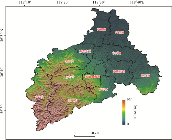
Figures(12) / Tables(3)

 DownLoad: