- 中文版:
- EI 100%收录
- 英文版
- SCI 100%收录


中国出版政府奖提名奖
中国百强科技报刊
湖北出版政府奖
中国高校百佳科技期刊
中国最美期刊
中国出版政府奖提名奖
中国百强科技报刊
湖北出版政府奖
中国高校百佳科技期刊
中国最美期刊
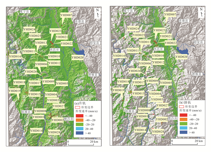
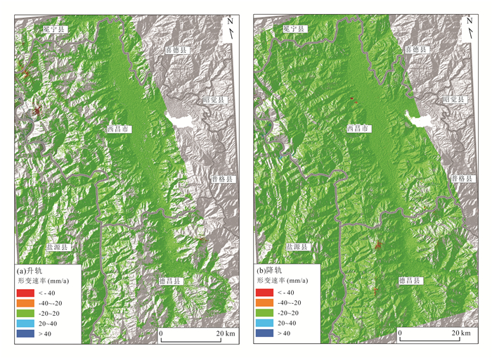
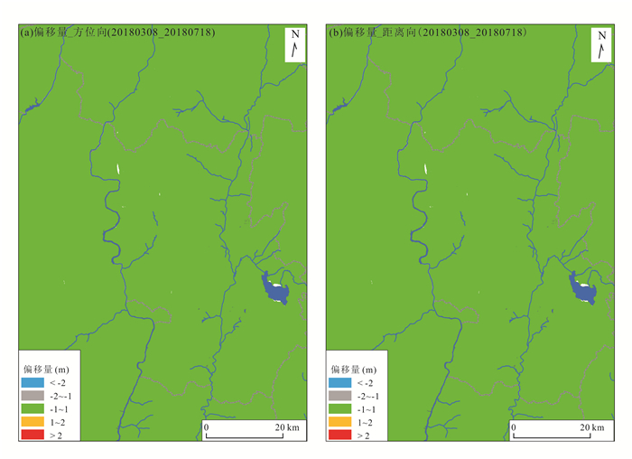
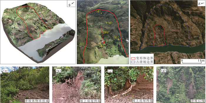
| Citation: | He Jiayang, Ju Nengpan, Xie Mingli, Wen Yan, Zuo Xuming, Deng Mingdong, 2023. Comparison of InSAR Technology for Identification of Hidden Dangers of Geological Hazards in Alpine and Canyon Areas. Earth Science, 48(11): 4295-4310. doi: 10.3799/dqkx.2022.308

|

|
Berardino, P., Fornaro, G., Lanari, R., et al., 2002. A New Algorithm for Surface Deformation Monitoring Based on Small Baseline Differential SAR Interferograms. IEEE Transactions on Geoscience & Remote Sensing, 40(11): 2375-2383. https://doi.org/10.1109/TGRS.2002.803792
|
|
Chen, F. L, Hui, L., Zhen, L., et al., 2012. Interaction between Permafrost and Infrastructure along the Qinghai–Tibet Railway Detected via Jointly Analysis of C- and L-band Small Baseline SAR Interferometry. Remote Sensing of Environment, 123: 532-540. https://doi.org/10.1016/j.rse.2012.04.020
|
|
Costantini, M., Ferretti, A., Minati, F., et al., 2017. Analysis of Surface Deformations over the Whole Italian Territory by Interferometric Processing of ERS, Envisat and COSMO-Sky Med Radar Data. Remote Sensing of Environment, 202: 250-275. doi: 10.1016/j.rse.2017.07.017
|
|
Dai, K., Chen, G., Xu, Q., et al., 2018. Potential Landslide Early Detection near Wenchuan by a Qualitatively Multi-baseline D InSAR Method. The International Archives of the Photogrammetry, Remote Sensing and Spatial Information Sciences, XLII-3: 253-256. doi: 10.5194/isprs-archives-XLII-3-253-2018
|
|
Ferretti, A., Prati, C., Rocca, F., 2001. Permanent Scatterers in SAR Interferometry. IEEE Transactions on Geoscience & Remote Sensing, 39(1): 8-20. https://doi.org/10.1109/36.898661
|
|
Gabriel, A. K., Goldstein, R. M., Zebker, H. A., 1989. Mapping Small Elevation Changes over Large Areas: Differental Radar Interferometry. Journal of Geophysical Research: Solid Earth, 94(B7): 9183-9191. doi: 10.1029/JB094iB07p09183
|
|
Gong, W., Thiele, A., Hinz, S., et al., 2016. Comparsion of Small Baseline Interferometric SAR Processors for Estimating Ground Deformation. Remote Sensing, 8(4): 330. doi: 10.3390/rs8040330
|
|
Grandin, R., Klein, E., Métois, M., et al., 2016. Three-Dimensional Displacement Field of the 2015 Mw 8.3 Illapel Earthquake (Chile) from Across- and Along-Track Sentinel-1 TOPS Interferometry. Geophysical Research Letters, 43(6): 2552-2561.
|
|
Hooper, A., Bekaert, D., Spaans, K., et al., 2012. Recent Advances in SAR Interferometry Time Series Analysis for Measuring Crustal Deformation. Tectonophysics, 514: 1-13.
|
|
Hu, X., Wang, T., Liao, M. S., 2014. Meassring Coseismic Displacements with Point-Like Targets Offset Tracking. IEEE Geoscience and Remote Sensing Letters, 11(1): 283-287. doi: 10.1109/LGRS.2013.2256104
|
|
Huang, R., Han, J. Q., Li, J. T., et al., 2021. Research on Application of PS-InSAR Technology in Subsidence Monitoring of Sino-Myanmar Oil and Gas Pipelines. Laser & Optoelectronics Progress, 59(16): 1628006 (in Chinese with English abstract).
|
|
Jiang, J. X., Du, Y. L., Chen, Y., et al., 2021. Monitoring and Analysis of Surface Deformation in Peibei Mining Region Based on DS-InSAR Technique. Bulletin of Surveying and Mapping, (2): 117-121 (in Chinese with English abstract).
|
|
Jiang, K. G., Wang, L., Teng, C. Q., et al., 2021. Research on Dynamic Monitoring Method of Surface Three-Dimensional Deformation of Coal Mine Based on Fusion of Single Sight D-InSAR and BK Model. Geomatics and Information Science of Wuhan University (in Chinese with English abstract).
|
|
Lanari, R., Mora, O., Manunta, M., et al., 2004. A Small-Baseline Approach for Investigating Deformations on Full-Resolution Differential SAR Interferograms. IEEE Transactions on Geoscience and Remote Sensing, 42(7): 1377-1386. doi: 10.1109/TGRS.2004.828196
|
|
Li, S., Wen, J. S., Hu, H. F., 2021. Research on Large Gradient Deformation of Mining Area Based on InSAR Technology. Science of Surveying and Mapping, 46(11): 56-62, 97 (in Chinese with English abstract).
|
|
Li, X. E., Zhou, L., Su, F. Z., et al., 2021. Application of InSAR Technology in Landslide Hazard: Progress and Prospects. Journal of Remote Sensing, 25(2): 614-629(in Chinese with English abstract).
|
|
Li, Z. H., Song, C., Yu, C., et al., 2019. Application of Satellite Radar Remote Sensing to Landslide Detection and Monitoring: Challenges and Solutions. Geomatics and Information Science of Wuhan University, 44(7): 967-979 (in Chinese with English abstract).
|
|
Lin, H., Ma, P. F., Wang, W. X., 2017. Urban Infrastructure Health Monitoring with Spaceborne Multi-Temporal Synthetic Aperture Radar Interferometry. Acta Geodaetica et Cartographica Sinica, 46(10): 1421-1433 (in Chinese with English abstract).
|
|
Liu, G. X., Chen, Q., Luo, X. J., et al., 2019. Principle and Application of InSAR. Science Press, Beijing, 9 (in Chinese).
|
|
Liu, P. Y., Chang, M., Wu, B. B., et al., 2022. Route Selection of Landslide Prone Area in Wenchuan Section of Chengdu-Wenchuan Expressway Based on SBAS-InSAR. Earth Science, 47(6): 2048-2057 (in Chinese with English abstract).
|
|
Mohammed, O. I., Saeidi, V., Pradhan, B., et al., 2014. Advanced Differential Interferometry Synthetic Aperture Radar Techniques for Deformation Monitoring: A Review on Sensors and Recent Research Development. Geocarto International, 29(5): 536-553. https://doi.org/10.1080/10106049.2013.807305
|
|
Raucoules, D., de Michele, M., Malet, J. P., et al., 2013. Time-Variable 3D Ground Displacements from High-Resolution Synthetic Aperture Radar (SAR): Application to La Valette Landslide (South French Alps). Remote Sensing of Environment, 139: 198-204. doi: 10.1016/j.rse.2013.08.006
|
|
Wang, X. L., Du, Y. L., Jiang, J. X., et al., 2021. Monitoring of Temporal and Spatial Evolution of Surface Deformation in Yuncheng Mining Area with DS-InSAR. Safety in Coal Mines, 52(5): 120-125 (in Chinese with English abstract).
|
|
Wang, X. M., Yin, J., Luo, M. H., et al., 2021. Active High-Locality Landslides in Mao County: Early Identification and Deformational Rules. Journal of Earth Science: 1-39.
|
|
Wang, X. W., Liu, G. X., Yu, B., et al., 2014.3D Coseismic Deformations and Source Parameters of the 2010 Yushu Earthquake (China) Inferred from D InSAR and Multiple-Aperture InSAR Measurements. Remote Sensing of Environment, 152: 174-189. doi: 10.1016/j.rse.2014.06.014
|
|
Wang, Z. D., Wen, X. H., Tang, W., et al., 2020. Early Detection of Geological Hazards in Longmenshan‐Dadu River Area Using Various InSAR Techniques. Geomatics and Information Science of Wuhan University, 45(3): 451-459 (in Chinese with English abstract).
|
|
Wu, H., Fan, H. D., Zhen, C. L, et al., 2022. Deformation Monitoring and Analysis of Tailings Dam Based on DS-InSAR: A Case Study of Brumadinho Mine in Brazil. Metal Mine (in Chinese with English abstract).
|
|
Xie, M. L., Zhao, J. J., Ju, N. P., et al., 2020. Research on Temporal and Spatial Evolution of Landslide Based on Multisource Data: A Case Study of Huangnibazi Landslide. Geomatics and Information Science of Wuhan University, 45(6): 923-932 (in Chinese with English abstract).
|
|
Xu, Q., Dong, X. J., Li, W. L., 2019. Integrated Space-Air-Ground Early Detection, Monitoring and Warning System for Potential Catastrophic Geohazards. Geomatics and Information Science of Wuhan University, 44(7): 957-966 (in Chinese with English abstract).
|
|
Xu, X. B., Ma, C., Shan, X. J., et al., 2020. Monitoring Ground Subsidence in High-Intensity Mining Area by Integrating D InSAR and Offset-Tracking Technology. Journal of Geo-Information Science, 22(12): 2425-2435 (in Chinese with English abstract).
|
|
Yang, C. S., Zhang, Q., Zhao, C. Y., et al., 2014. Small Baseline Bubset InSAR Technology Used in Datong Basin Ground Subsidence, Fissure and Fault Zone Monitoring. Geomatics and Information Science of Wuhan University, 39(8): 945-950 (in Chinese with English abstract).
|
|
Zhang, L., Liao, M. S., Dong, J., et al., 2018. Early Detection of Landslide Hazards in Mountainous Areas of West China Using Time Series SAR Interferometry—A Case Study of Danba, Sichuan. Geomatics and Information Science of Wuhan University, 43(12): 2039-2049 (in Chinese with English abstract).
|
|
Zhao, G. P., 2016. Structure Character Research of the Daliang Mountain in the Southern Margin of Sichuan Basin (Dissertation). Chengdu University of Technology, Chengdu, 7-8 (in Chinese with English abstract).
|
|
Zhou, D. Y., Zuo, X. Q., Xi, W. F., et al., 2022. Early Identification of Landslide Hazards in Deep Cut Alpine Canyon Using SBAS-InSAR Technology. The Chinese Journal of Geological Hazard and Control, 33(2): 16-24 (in Chinese with English abstract).
|
|
Zhuo, G. C., Dai, K. R., Zhou, F. J., et al., 2021. Monitoring Typical Construction Sites of Sichuan-Tibet Railway by InSAR and Intensive Distortion Analysis. Earth Science (in Chinese with English abstract).
|
|
黄锐, 韩建强, 李进田, 等, 2021. PS-InSAR技术在中缅油气管道沉降监测中的应用研究. 激光与光电子学进展, 59(16): 1628006. https://www.cnki.com.cn/Article/CJFDTOTAL-JGDJ202216053.htm
|
|
蒋金雄, 杜玉玲, 陈宇, 等, 2021. 利用DS-InSAR技术监测沛北矿区地表形变. 测绘通报, (2): 117-121. https://www.cnki.com.cn/Article/CJFDTOTAL-CHTB202102024.htm
|
|
江克贵, 王磊, 滕超群, 2021. 融合单视线D-InSAR和BK模型的煤矿地表三维变形动态监测方法研究. 武汉大学学报(信息科学版). https://www.cnki.com.cn/Article/CJFDTOTAL-WHCH202304015.htm
|
|
李帅, 温建生, 胡海峰, 2021. 融合InSAR技术的矿区大梯度形变研究. 测绘科学, 46(11): 56-62, 97. https://www.cnki.com.cn/Article/CJFDTOTAL-CHKD202111009.htm
|
|
李晓恩, 周亮, 苏奋振, 等, 2021. InSAR技术在滑坡灾害中的应用研究进展. 遥感学报, 25(2): 614-629. https://www.cnki.com.cn/Article/CJFDTOTAL-YGXB202102008.htm
|
|
李振洪, 宋闯, 余琛, 等, 2019. 卫星雷达遥感在滑坡灾害探测和监测中的应用: 挑战与对策. 武汉大学学报(信息科学版), 44(7): 967-979. https://www.cnki.com.cn/Article/CJFDTOTAL-WHCH201907003.htm
|
|
林珲, 马培峰, 王伟玺, 2017. 监测城市基础设施健康的星载MT-InSAR方法介绍. 测绘学报, 46(10): 1421-1433. https://www.cnki.com.cn/Article/CJFDTOTAL-CHXB201710026.htm
|
|
刘国祥, 陈强, 罗小军, 等, 2019. InSAR原理与应用. 北京: 科学出版社, 9. https://www.cnki.com.cn/Article/CJFDTOTAL-CXYY201520027.htm
|
|
刘沛源, 常鸣, 武彬彬, 等, 2022. 基于SBAS-InSAR技术的成汶高速汶川段滑坡易发区选线研究. 地球科学, 47(6): 2048-2057. doi: 10.3799/dqkx.2022.069
|
|
王新玲, 杜玉玲, 蒋金雄, 等, 2021. 郓城矿区地表形变时空演变DS-InSAR监测. 煤矿安全, 52(5): 120-125. https://www.cnki.com.cn/Article/CJFDTOTAL-MKAQ202105020.htm
|
|
王之栋, 文学虎, 唐伟, 等, 2020. 联合多种InSAR技术的龙门山‒大渡河区域地灾隐患早期探测. 武汉大学学报(信息科学版), 45(3): 451-459. https://www.cnki.com.cn/Article/CJFDTOTAL-WHCH202003017.htm
|
|
吴昊, 范洪冬, 郑春柳, 等, 2022. 基于DS-InSAR的尾矿库变形监测与分析——以巴西Brumadinho矿为例. 金属矿山.
|
|
解明礼, 赵建军, 巨能攀, 等, 2020. 多源数据滑坡时空演化规律研究: 以黄泥坝子滑坡为例. 武汉大学学报(信息科学版), 45(6): 923-932. https://www.cnki.com.cn/Article/CJFDTOTAL-WHCH202006016.htm
|
|
许强, 董秀军, 李为乐, 2019. 基于天‒空‒地一体化的重大地质灾害隐患早期识别与监测预警. 武汉大学学报(信息科学版), 44(7): 957-966. https://www.cnki.com.cn/Article/CJFDTOTAL-WHCH201907002.htm
|
|
徐小波, 马超, 单新建, 等, 2020. 联合D InSAR与Offset-tracking技术监测高强度采区开采沉陷的方法. 地球信息科学学报, 22(12): 2425-2435. https://www.cnki.com.cn/Article/CJFDTOTAL-DQXX202012014.htm
|
|
杨成生, 张勤, 赵超英, 等, 2014. 短基线集InSAR技术用于大同盆地地面沉降、地裂缝及断裂活动监测. 武汉大学学报(信息科学版), 39(8): 945-950. https://www.cnki.com.cn/Article/CJFDTOTAL-WHCH201408012.htm
|
|
张路, 廖明生, 董杰, 等, 2018. 基于时间序列InSAR分析的西部山区滑坡灾害隐患早期识别: 以四川丹巴为例. 武汉大学学报(信息科学版), 43(12): 2039-2049. https://www.cnki.com.cn/Article/CJFDTOTAL-WHCH201812031.htm
|
|
赵高平, 2016. 四川盆地南缘大凉山地区构造特征研究(硕士学位论文). 成都: 成都理工大学, 7-8.
|
|
周定义, 左小清, 喜文飞, 等, 2022. 基于SBAS-InSAR技术的深切割高山峡谷区滑坡灾害早期识别. 中国地质灾害与防治学报, 33(2): 16-24. https://www.cnki.com.cn/Article/CJFDTOTAL-ZGDH202202003.htm
|
|
卓冠晨, 戴可人, 周福军, 等, 2021. 川藏铁路典型工点InSAR监测及几何畸变精细判识. 地球科学.
|
Figures(20) / Tables(4)


 DownLoad: