- 中文版:
- EI 100%收录
- 英文版
- SCI 100%收录


中国出版政府奖提名奖
中国百强科技报刊
湖北出版政府奖
中国高校百佳科技期刊
中国最美期刊
中国出版政府奖提名奖
中国百强科技报刊
湖北出版政府奖
中国高校百佳科技期刊
中国最美期刊
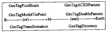
| Citation: | LIU Xiu-guo, HUA Wei-hua, 2002. Analysis of GeoTag Fields in GeoTiff. Earth Science, 27(3): 246-249.

|

| [1] |
吴信才. 地理信息系统的基本技术与发展动态[J]. 地球科学———中国地质大学学报, 1998, 23(4): 329-333. https://www.cnki.com.cn/Article/CJFDTOTAL-CXYY201933059.htm
WUX C. Basic technology and development of geographic information system[J]. Earth Science—Journal of China University of Geosciences, 1998, 23(4): 329-333. https://www.cnki.com.cn/Article/CJFDTOTAL-CXYY201933059.htm
|
| [2] |
赵士滨. 计算机图形图像设计与技巧[M]. 广州: 广东科技出版社, 1998. 53-70.
ZHAO S B. The design and technique of computer graphics and image[M]. Guangzhou: Guangdong Science and Technology Press, 1998. 53-70.
|
| [3] |
李超岭, 张克信. 基于GIS技术的区域性多源地学空间信息集成若干问题探讨[J]. 地球科学———中国地质大学学报, 2001, 25(6): 545-550. https://www.cnki.com.cn/Article/CJFDTOTAL-DQKX200105021.htm
LI C L, ZHANG K X. Study on regional multi-source geological spatial information system based on techniques of GIS[J]. Earth Science—Journal of China University of Geosciences, 2001, 25(6): 545-550. https://www.cnki.com.cn/Article/CJFDTOTAL-DQKX200105021.htm
|
| [4] |
林福宗. 图像文件格式(下)———Windows编程[M]. 北京: 清华大学出版社, 1996. 188-218.
LINF Z. Image file format(second)—Windows programming [M]. Beijing: Tsinghua University Press, 1996. 188-218.
|
| [5] |
Niles R, Ruth M. GeoTIFF format specification GeoTIFF revision 1.0[EB/OL]. http://www.mipl.jpl.nasa.gov/cartlab/geotiff/geotiff.doc. 1995.
|
| [6] |
李军, 吴信才, 王静. 多源图像处理与分析系统的设计[J]. 地球科学———中国地质大学学报, 1998, 23(4): 375-378.
LI J, WU X C, WANG J. Design of multisource image processing and analysis system[J]. Earth Science—Journal of China University of Geosciences, 1998, 23(4): 375-378.
|
| [7] |
Adobe Developers Association. Adobe systems incorporated TIFF[EB/OL]. http://www.adobe.com/support/technotes.html. 1992.
|
Figures(2)


 DownLoad: