
- 中文版:
- EI 100%收录
- 英文版
- SCI 100%收录


中国出版政府奖提名奖
中国百强科技报刊
湖北出版政府奖
中国高校百佳科技期刊
中国最美期刊
中国出版政府奖提名奖
中国百强科技报刊
湖北出版政府奖
中国高校百佳科技期刊
中国最美期刊
| Citation: | YANG Jun, XU Shi-wu, 2002. Design and Implementation of Land Use Database System for County Level of MAPGIS. Earth Science, 27(3): 297-300.

|

| [1] |
徐世武, 张发勇, 刘秀珍. 地理信息系统在地籍管理系统中的应用[J]. 地球科学———中国地质大学学报, 1998, 23 (4): 424-426. https://www.cnki.com.cn/Article/CJFDTOTAL-DQKX804.029.htm
XU S W, ZHANG F Y, LIU X Z. Application of geographic
information system in cadastral management system[J]. Earth
Science—Journal of China University ofGeosciences, 1998, 23 (4): 424-426. https://www.cnki.com.cn/Article/CJFDTOTAL-DQKX804.029.htm
|
| [2] |
樊文有, 谢忠. GIS空间数据的误差校正[J]. 地球科学———中国地质大学学报, 1998, 23 (4): 344-347. https://www.cnki.com.cn/Article/CJFDTOTAL-DQKX804.006.htm
FAN W Y, XIE Z. Error rectification of geographic information
system map data[J]. Earth Science—Journal of China University of Geosciences, 1998, 23 (4): 344-347. https://www.cnki.com.cn/Article/CJFDTOTAL-DQKX804.006.htm
|
| [3] |
周顺平, 袁国斌. 弧段拓扑信息中左右多边形的自动判断方法[J]. 地球科学———中国地质大学学报, 1998, 23 (4): 348-350. https://www.cnki.com.cn/Article/CJFDTOTAL-DQKX804.007.htm
ZHOU S P, YUAN G B. Automatic judgment method of left-
right polygon in arc topological information[J]. Earth Science—Journal of China University of Geosciences, 1998, 1998, 23 (4): 348-350. https://www.cnki.com.cn/Article/CJFDTOTAL-DQKX804.007.htm
|
| [4] |
李超岭, 张克信. 基于GIS技术的区域性多源地学空间信息集成若干问题探讨[J]. 地球科学———中国地质大学学报, 2001, 25 (6): 545-550. https://www.cnki.com.cn/Article/CJFDTOTAL-DQKX200105021.htm
LI C L, ZHANG K X. Study on regional multi-source geological spatial information system based on techniques of GIS[J].
Earth Science—Journal of China University of Geosciences, 2001, 25 (6): 545-550. https://www.cnki.com.cn/Article/CJFDTOTAL-DQKX200105021.htm
|
| [5] |
张夏林, 汪新庆, 吴冲龙. 计算机辅助地质填图属性数据采集子系统的动态数据模型[J]. 地球科学———中国地质大学学报, 2001, 26 (2): 201-204. https://www.cnki.com.cn/Article/CJFDTOTAL-DQKX200102021.htm
ZHANG X L, WANG X Q, WU C L. Dynamic data model applied in regional geological mapping computer-aided mapping
system[J]. Earth Science—Journal of China University of
Geosciences, 2001, 26 (2): 201-204. https://www.cnki.com.cn/Article/CJFDTOTAL-DQKX200102021.htm
|
| [6] |
戴福初, 李军, 张晓晖. 城市建设用地与地质环境协调性评价的GIS方法及其应用[J]. 地球科学———中国地质大学学报, 2000, 25 (2): 209-214. https://www.cnki.com.cn/Article/CJFDTOTAL-DQKX200002019.htm
DAI F C, LI J, ZHANG X H. GIS method and its applications
to evaluation of coordination between urban land use and geoenvironmental potential[J]. Earth Science—Journal of China
University of Geosciences, 2000, 25 (2): 209-214. https://www.cnki.com.cn/Article/CJFDTOTAL-DQKX200002019.htm
|
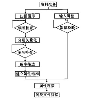
Figures(1)


 DownLoad: