- 中文版:
- EI 100%收录
- 英文版
- SCI 100%收录


中国出版政府奖提名奖
中国百强科技报刊
湖北出版政府奖
中国高校百佳科技期刊
中国最美期刊
中国出版政府奖提名奖
中国百强科技报刊
湖北出版政府奖
中国高校百佳科技期刊
中国最美期刊
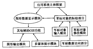
| Citation: | LIU Dan, CHEN Yu, ZHANG Jian-bo, 2002. A Military Marker Mapping System Based on MAPGIS. Earth Science, 27(3): 301-305.

|

| [1] |
谢忠, 付京波. 基于MAPGIS的军事指挥系统的设计[J]. 地球科学———中国地质大学学报, 1998, 23 (4): 369-371. https://www.cnki.com.cn/Article/CJFDTOTAL-DQKX804.014.htm
XIE Z, FU J B. Military command system based on MAPGIS
[J]. Earth Science—Journal of China University of Geosciences, 1998, 23 (4): 369-371. https://www.cnki.com.cn/Article/CJFDTOTAL-DQKX804.014.htm
|
| [2] |
周顺平, 李雪平. MAPGIS二次开发库的设计与实现简介[J]. 地球科学———中国地质大学学报, 1998, 23 (4): 337-340. https://www.cnki.com.cn/Article/CJFDTOTAL-DQKX804.004.htm
ZHOU S P, LI X P. MAPGIS design and realization in the
secondary-developed functions set[J]. Earth Science—Journal
of China University of Geosciences, 1998, 23 (4): 337-340. https://www.cnki.com.cn/Article/CJFDTOTAL-DQKX804.004.htm
|
| [3] |
袁艳斌, 吴冲龙, 李伟忠. 面向野外地质填图的空间实体对象表达[J]. 地球科学———中国地质大学学报, 2001, 26 (2): 192-196. https://www.cnki.com.cn/Article/CJFDTOTAL-DQKX200102019.htm
YUAN Y B, WU C L, LI W Z. Object styles of spatial entity
for field geological mapping based on object-oriented method
[J]. Earth Science—Journal of China University of Geosciences, 2001, 26 (2): 192-196. https://www.cnki.com.cn/Article/CJFDTOTAL-DQKX200102019.htm
|
| [4] |
刘刚, 韩志军, 罗映娟, 等. 资源勘查信息系统中参数化图形设计方法的应用框架研究[J]. 地球科学———中国地质大学学报, 2001, 26 (2): 197-200. https://www.cnki.com.cn/Article/CJFDTOTAL-DQKX200102020.htm
LIU G, HAN Z J, LUO Y J, et al. Research into application
framework of parametric design method of computer-aided map
generation in resources exploration information system[J].
Earth Science—Journal of China University of Geosciences, 2001, 26 (2): 197-200. https://www.cnki.com.cn/Article/CJFDTOTAL-DQKX200102020.htm
|
| [5] |
周成虎, 李军. 地球空间元数据研究[J]. 地球科学———中国地质大学学报, 2000, 25 (6): 579-585. https://www.cnki.com.cn/Article/CJFDTOTAL-DQKX200006006.htm
ZHOU C H, LI J. Research into geo-spatial metadata[J].
Earth Science—Journal of China University of Geosciences, 2000, 25 (6): 579-585. https://www.cnki.com.cn/Article/CJFDTOTAL-DQKX200006006.htm
|
| [6] |
李超岭, 张克信. 基于GIS技术的区域性多源地学空间信息集成若干问题探讨[J]. 地球科学———中国地质大学学报, 2001, 25 (6): 545-550. https://www.cnki.com.cn/Article/CJFDTOTAL-DQKX200105021.htm
LI C L, ZHANG K X. Study on regional multi-source geological spatial information system based on techniques of GIS[J].
Earth Science—Journal of China University of Geosciences, 2001, 25 (6): 545-550. https://www.cnki.com.cn/Article/CJFDTOTAL-DQKX200105021.htm
|
| [7] |
潘继平, 王华, 甘甫平. 基于GIS的石油勘探图形库系统分析和设计[J]. 地球科学———中国地质大学学报, 2002, 27 (1): 59-62. https://www.cnki.com.cn/Article/CJFDTOTAL-DQKX200201012.htm
PAN J P, WANG H, GAN F P. Analysis and designing of
GIS-based graph and image database system of petroleum exploration[J]. Earth Science—Journal of China University of Geosciences, 2002, 27 (1): 59-62. https://www.cnki.com.cn/Article/CJFDTOTAL-DQKX200201012.htm
|
| [8] |
张夏林, 汪新庆, 吴冲龙. 计算机辅助地质填图属性数据采集子系统的动态数据模型[J]. 地球科学———中国地质大学学报, 2001, 26 (2): 201-204. https://www.cnki.com.cn/Article/CJFDTOTAL-DQKX200102021.htm
ZHANG X L, WANG X Q, WU C L. Dynamic data model applied in regional geological mapping computer-aided mapping
system[J]. Earth Science—Journal of China University of
Geosciences, 2001, 26 (2): 201-204. https://www.cnki.com.cn/Article/CJFDTOTAL-DQKX200102021.htm
|
Figures(5)


 DownLoad: