- 中文版:
- EI 100%收录
- 英文版
- SCI 100%收录


中国出版政府奖提名奖
中国百强科技报刊
湖北出版政府奖
中国高校百佳科技期刊
中国最美期刊
中国出版政府奖提名奖
中国百强科技报刊
湖北出版政府奖
中国高校百佳科技期刊
中国最美期刊
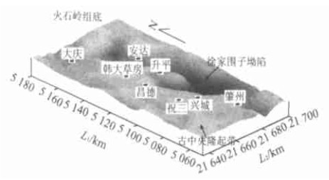
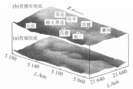
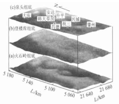
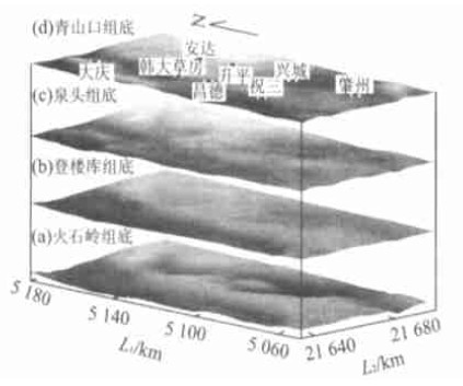
| Citation: | LIU Xue-feng, MENG Ling-kui, HUANG Zhang-qing, ZHAO Chun-yu, 2003. GIS-Based Reconstruction of Basin Paleotectonics: An Example from Paleo-Central Uplift Belt, Northern Songliao Basin. Earth Science, 28(3): 346-350.

|

| [1] |
吴信才. 地理信息系统的基本技术与发展动态[J]. 地球科学——中国地质大学学报, 1998, 23(4): 329-333. https://www.cnki.com.cn/Article/CJFDTOTAL-CXYY201933059.htm
WU X C. Basic technology and development of geographic information system[J]. Earth Science— Journal of China University of Geosciences, 1998, 23(4): 329-333. https://www.cnki.com.cn/Article/CJFDTOTAL-CXYY201933059.htm
|
| [2] |
Allen P A, Allen J R. Basin analysis principles and applications[M]. London: Blackwell Scientific Publications, 1990. 263-281.
|
| [3] |
Steckler M S, Watts A B. Subsidence of the Atlantic type continental margin of New York[J]. Earth and Planetary Science Letters, 1978, 41: 1-13. doi: 10.1016/0012-821X(78)90036-5
|
| [4] |
Watts A B. Tectonic subsidence, flexure and global changes of sea level[J]. Nature, 1982, 297: 469-474. doi: 10.1038/297469a0
|
| [5] |
Sawyer D S. Total tectonic subsidence: a parameter for distinguishing crust type at the U S, Atlantic continental margin[J]. Journal of Geophysical Research, 1985, 90 (B9): 7751-7769. doi: 10.1029/JB090iB09p07751
|
| [6] |
刘学锋. 对Watts等构造沉降量公式的修正[J]. 石油勘探与开发, 1997, 24(3): 82-85. doi: 10.3321/j.issn:1000-0747.1997.03.020
LIU X F. A revision to Watts formula used to calculate tectonic subsidence[J]. Petroleum Exploration and Development, 1997, 24(3): 82-85. doi: 10.3321/j.issn:1000-0747.1997.03.020
|
| [7] |
刘学锋, 刘绍平. 巴彦浩特盆地沉降史分析[J]. 西安石油学院学报, 1997, 12(2): 25-31. https://www.cnki.com.cn/Article/CJFDTOTAL-XASY702.002.htm
LIU X F, LIU S P. Subsidence history analysis of Bayanhot basin[J]. Journal of Xi'an Petroleum Institute, 1997, 12(2): 25-31. https://www.cnki.com.cn/Article/CJFDTOTAL-XASY702.002.htm
|
| [8] |
刘学锋, 何幼斌, 张或丹. 利用回剥分析重建古构造格局[J]. 古地理学报, 1999, 1(2): 15-21. https://www.cnki.com.cn/Article/CJFDTOTAL-GDLX199902006.htm
LIU X F, HE Y B, ZHANG H D. Paleotectonic reconstruction using backstripping analysis[J]. Journal of Palaeogeography, 1999, 1(2): 15-21. https://www.cnki.com.cn/Article/CJFDTOTAL-GDLX199902006.htm
|
| [9] |
郭仁忠. 空间分析[M]. 武汉: 武汉测绘科技大学出版社, 2000.
GUO RZ. Spatial analysis[M]. Wuhan: Wuhan Technical University of Surveying and Mapping Press, 2000.
|
| [10] |
李志林, 朱庆. 数字高程模型[M]. 武汉: 武汉大学出版社, 2001.
LI Z L, ZHU Q. Digital elevation model[M]. Wuhan: Wuhan University Press, 2001.
|
| [11] |
郭占谦. 松辽盆地的类型及形成与演化[J]. 地球科学——中国地质大学学报, 1998, 23(增刊): 21-26.
GUO Z Q. Types, formation and evolution of Songliao basin[J]. Earth Science— Journal of China University of Geosciences, 1998, 23(Suppl): 21-26.
|
| [12] |
张功成, 蔡希源, 周章保, 等. 裂陷盆地分析原理与方法[M]. 北京: 石油工业出版社, 1996.
ZHANG G C, CAI X Y, ZHOU Z B, et al. Rift basin analysis and its principles and methods[M]. Beijing: Petroleum Industry Press, 1996.
|

Figures(6)


 DownLoad: