- 中文版:
- EI 100%收录
- 英文版
- SCI 100%收录


中国出版政府奖提名奖
中国百强科技报刊
湖北出版政府奖
中国高校百佳科技期刊
中国最美期刊
中国出版政府奖提名奖
中国百强科技报刊
湖北出版政府奖
中国高校百佳科技期刊
中国最美期刊
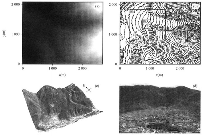
| Citation: | CHEN Gui-hua, XU Xi-wei, WEN Xue-ze, WANG Ya-li, ZHENG Rong-zhang, 2006. Application of Digital Aerophotogrammetry in Active Tectonics. Earth Science, 31(3): 405-410.

|

|
Chen, X. N., Cheng, Y. H., 1998. Analysis of the photograph scanner for digital photogrammetry. Scientific and Technical Communication of Surveying and Mapping, 21(3): 34-37, 33(in Chinese).
|
|
Deng, Q. D., Chen, L. C., Ran, Y. K., 2004. Quantitative studies and applications of active tectonics. Earth Science Frontiers, 11(4): 383-392(in Chinese with English abstract).
|
|
Ganas, A., Pavlides, S., Karastathis, V., 2005. DEM-based morphometry of range-front escarpments in Attica, central Greece, and its relation to fault slip rates. Geomorphology, 65(3-4): 301-319. doi: 10.1016/j.geomorph.2004.09.006
|
|
Gong, P., 2000. Digital surface model and topographic change monitoring. Quaternary Sciences, 20(3): 247-251(in Chinese with English abstract). doi: 10.3321/j.issn:1001-7410.2000.03.005
|
|
Huang, J., 2002. Checking on the quality of DEM. Bulletin of Surveying and Mapping, (2): 55-56(in Chinese with English abstract).
|
|
Lasserre, C., Morel, P. H., Gaudemer, Y., et al., 1999. Postglacial left slip rate and past occurrence of M≥8 earthquakes on the western Haiyuan fault, Gansu, China. J. Geophys. Res. , 104: 17633-17651. doi: 10.1029/1998JB900082
|
|
Riquelme, R., Martinod, J., Hérail, G., et al., 2003. A geomorphological approach to determining the Neogene to recent tectonic deformation in the Coastal Cordillera of northern Chile(Atacama). Tectonophysics, 361(3-4): 255-275. doi: 10.1016/S0040-1951(02)00649-2
|
|
Wang, D., 1995. About the mapping precision of aerial photogrammetry. Geotechnical Investigation & Surveying, (6): 42-46, 41(in Chinese with English abstract).
|
|
Xu, X. W., Wen, X. Z., Zheng, R. Z., et al., 2003. Pattern of latest tectonic motion and its dynamics for active blocks in Sichuan-Yunnan region, China. Science in China(Series D), 46(Suppl. 1): 210-226. doi: 10.1360/03dz0017
|
|
Xu, X. W., Yu, G. H., Ma, W. T., et al., 2002. Evidence and methods for determining the safety distance from the potential earthquake surface rupture on active fault. Seismology and Geology, 22(4): 470-483(in Chinese with English abstract).
|
|
Zhang, J. Q., Pan, L., Wang, S. G., 2003. Photogrammetry. Wuhan University Press, Wuhan(in Chinese).
|
|
Zhang, S. H., Lü, L. S., Wang, S. J., 2000. Discussion on full digital photogrammetry and 4D product. Remote Sensing In formation, (4): 68-73(in Chinese with English abstract).
|
|
陈晓宁, 成燕辉, 1998. 用于数字摄影测量的影像扫描仪剖析. 测绘科技通讯, 21(3): 34-37, 33. https://www.cnki.com.cn/Article/CJFDTOTAL-CHKJ199803010.htm
|
|
邓起东, 陈立春, 冉勇康, 2004. 活动构造定量研究与应用. 地学前缘, 11(4): 383-392. doi: 10.3321/j.issn:1005-2321.2004.04.005
|
|
宫鹏, 2000. 数字表面模型与地形变化测量. 第四纪研究, 20(3): 247-251. doi: 10.3321/j.issn:1001-7410.2000.03.005
|
|
黄健, 2002. 数字高程模型的质量检查. 测绘通报, (2): 55-56. doi: 10.3969/j.issn.0494-0911.2002.02.021
|
|
王丹, 1995. 关于航空摄影测量制图的精度问题. 工程勘察, (6): 42-46, 41. https://www.cnki.com.cn/Article/CJFDTOTAL-GCKC506.011.htm
|
|
徐锡伟, 闻学泽, 郑荣章, 等, 2003. 川滇地区活动块体最新构造变动样式及其动力来源. 中国科学(D辑), 33(Suppl. 1): 151-162. https://www.cnki.com.cn/Article/CJFDTOTAL-JDXK2003S1016.htm
|
|
徐锡伟, 于贵华, 马文涛, 等, 2002. 活断层地震地表破裂"避让带"宽度确定的依据与方法. 地震地质, 22(4): 470-483. doi: 10.3969/j.issn.0253-4967.2002.04.001
|
|
张剑清, 潘励, 王树根, 2003. 摄影测量学. 武汉: 武汉大学出版社.
|
|
张书煌, 吕良寿, 王苏京, 2000. 全数字摄影测量与4D技术探讨. 遥感信息, (4): 68-73. doi: 10.3969/j.issn.1000-3177.2000.04.024
|

Figures(5)


 DownLoad: