- 中文版:
- EI 100%收录
- 英文版
- SCI 100%收录


中国出版政府奖提名奖
中国百强科技报刊
湖北出版政府奖
中国高校百佳科技期刊
中国最美期刊
中国出版政府奖提名奖
中国百强科技报刊
湖北出版政府奖
中国高校百佳科技期刊
中国最美期刊
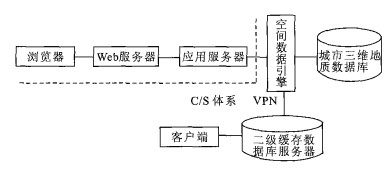
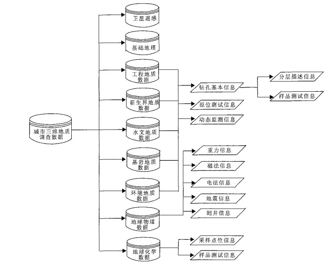
| Citation: | ZHENG Kun, HOU Wei-sheng, LIU Xiu-guo, 2006. Database Designed for Urban 3D Geological Investigations. Earth Science, 31(5): 678-682.

|

|
Dai, Q. F., Wei, H. L., Su, G. H., et al., 2004. Modeling of marine geological survey database. Application Research of Computers, 21 (3): 65-66 (in Chinese with English abstract).
|
|
Hu, J. W., Wu, X. C., Song, L. H., 2003. Technique for isomeric database design in environment GIS application. Journal of Jilin Post and Telecommunication Institute, 21 (1): 61-64 (in Chinese with English abstract).
|
|
Hu, Z. Y., He, J. B., 2000. The architecture and technical solution of distributed geographical information sharing. Computer Engineering and Applications, 36 (12) 51-54 (in Chinese with English abstract).
|
|
ISO/TC 211 Secretariat, 2001. DIS 19115 geographic information-metadata. ISO, [s. n.].
|
|
Liu, Y. B., Liu, D. Y., 2000. A review on spatial reasoning and geographic information system. Journal of Software, 11 (12): 1598-1606 (in Chinese with English abstract).
|
|
Wu, X. C., Bai, Y. Q., 2000. Development and prospect of geographic information system. Computer Engineering and Applications, 36 (4): 8-9 (in Chinese with English abstract).
|
|
Zhu, L. F., Wu, X. C., 2003. Study of management and service system of urban 3D geological data supported by 3D GIS. Journal of Wuhan Urban Construction Institute, 20 (4): 40-46.
|
|
Zhu, L. F., Wu, X. C., Liu, X. G., 2004. Study of information system of urban 3D geological data supported by 3D GIS. Rock and Soil Mechanics, 23 (6): 882-886 (in Chinese with English abstract).
|
|
戴勤奋, 魏合龙, 苏国辉, 等, 2004. 区域海洋地质调查数据库结构模型. 计算机应用研究, 21 (3): 65-66. doi: 10.3969/j.issn.1001-3695.2004.03.023
|
|
胡建武, 吴信才, 宋利好, 2003. 环境地理信息系统中异构数据库的设计. 吉林大学学报(信息科学版), 21 (1): 61-64. doi: 10.3969/j.issn.1671-5896.2003.01.013
|
|
胡志勇, 何建邦, 2000. 分布式地理信息共享形式及技术策略. 计算机工程与应用, 36 (12): 51-54. doi: 10.3321/j.issn:1002-8331.2000.12.020
|
|
刘亚彬, 刘大友, 2000. 空间推理和地理信息系统综述. 软学报, 11 (12): 1598-1606. https://www.cnki.com.cn/Article/CJFDTOTAL-RJXB200012005.htm
|
|
吴信才, 白玉琪, 2000. 地理信息系统(GIS) 发展现状及展望. 计算机工程与应用, 36 (4): 8-9. doi: 10.3321/j.issn:1002-8331.2000.04.003
|
|
朱良峰, 吴信才, 刘修国, 2004.3D GIS支持下的城市三维地质信息系统研究. 岩土力学, 23 (6): 882-886. doi: 10.3969/j.issn.1000-7598.2004.06.008
|
Figures(3)


 DownLoad: