- 中文版:
- EI 100%收录
- 英文版
- SCI 100%收录


中国出版政府奖提名奖
中国百强科技报刊
湖北出版政府奖
中国高校百佳科技期刊
中国最美期刊
中国出版政府奖提名奖
中国百强科技报刊
湖北出版政府奖
中国高校百佳科技期刊
中国最美期刊
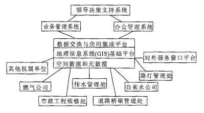
| Citation: | CENG Wen, ZHANG De-jin, 2006. Scheme and Key Techniques for GIS-Based Integration of Municipal Management Information. Earth Science, 31(5): 688-692.

|

|
Inmon, W. H., 1996. The data warehouse and data mining. Communications of the ACM, 39 (11): 49-50. doi: 10.1145/240455.240470
|
|
Mao, K. B., Tian, Q. J., 2002. The technology and methods of spatial data mining and their application. Remote Sensing Technology and Application, 17 (4): 198-204 (in Chinese with English abstract).
|
|
Roberts, A. M., Moore, R. V., 1998. Data and databases for decision support. Hydrological Processes, 12 (6): 835-842. doi: 10.1002/(SICI)1099-1085(199805)12:6<835::AID-HYP657>3.0.CO;2-P
|
|
Sussman, R., 1996. Implementing municipal GIS: Human behaviour and the decision-making process. Computer, Environment and Urban Systems, 20 (3): 213-223. doi: 10.1016/S0198-9715(96)00016-6
|
|
Yan, Z., Jiang, J. T., He, J. B., et al., 1998. Manual of standardization of urban geographic information systems. Science Press, Beijing. 20-21 (in Chinese).
|
|
Zeng, W., Zhang, D. J., 2002. Design of MAPGIS pipeline management development platform. Earth Science—Journal of China University of Geosciences, 27 (3): 250-254 (in Chinese with English abstract).
|
|
毛克彪, 田庆久, 2002. 空间数据挖掘技术方法及应用. 遥感技术与应用, 17 (4): 198-204. doi: 10.3969/j.issn.1004-0323.2002.04.005
|
|
阎正, 蒋景瞳, 何建邦, 等, 1998. 城市地理信息系统标准化指南. 北京: 科学出版社. 20-21.
|
|
曾文, 张德津, 2002. MAPGIS管网开发平台的设计. 地球科学——中国地质大学学报, 27 (3): 250-254. https://www.cnki.com.cn/Article/CJFDTOTAL-DQKX200203002.htm
|

Figures(3)


 DownLoad: