2008 Vol. 33, No. 1
Display Method:
2008, 33(1): 1-11.
 PDF 3203KB
Abstract:
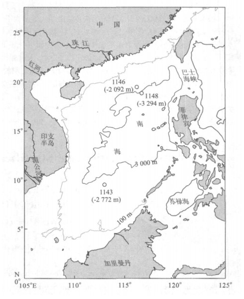
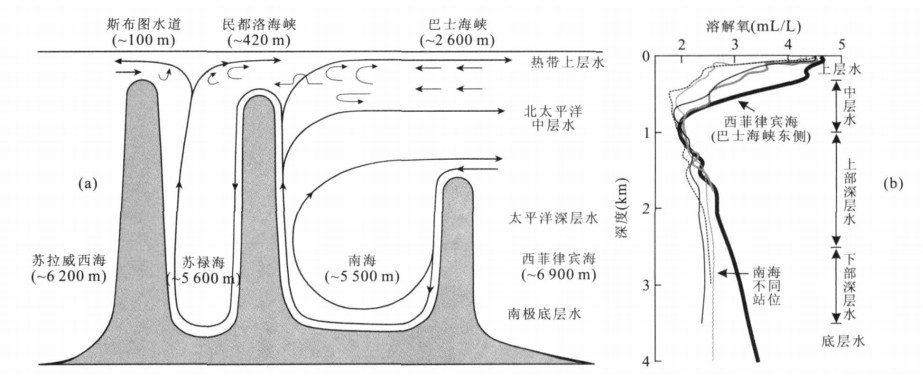
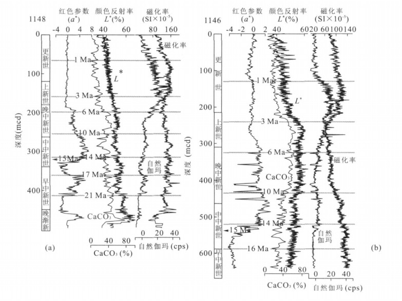
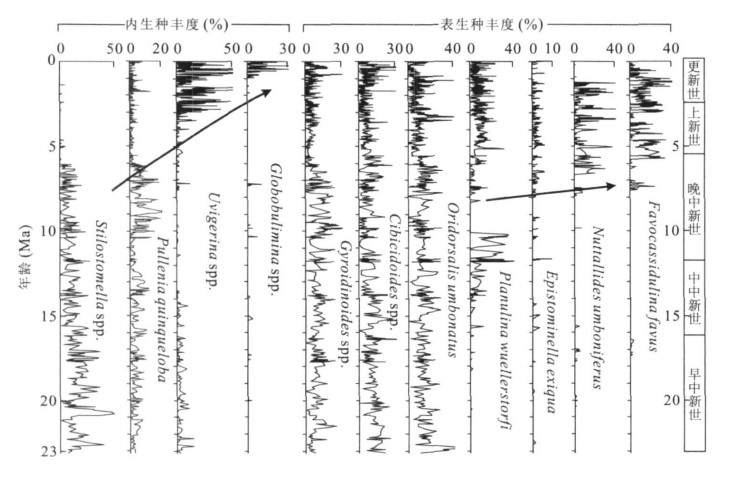
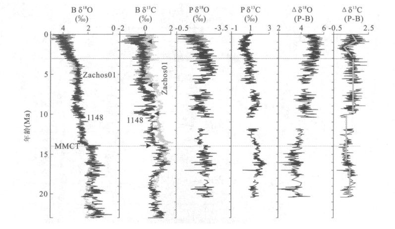
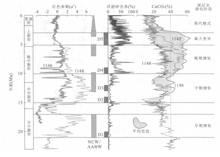
Combined data of physical property, benthic foraminifera and stable isotopes from ODP Sites 1148, 1146 and 1143 are used to discuss deep water evolution in the South China Sea (SCS) since the Early Miocene. The results indicate that 3 lithostratigraphic units respectively corresponding to 21-17 Ma, 15-10 Ma and 10-5 Ma with positive red parameter (a*) marking the red brown sediment color represent 3 periods of deep water ventilation. The first 2 periods show a closer link to contemporary production of the Antarctic Bottom Water (ABW) and Northern Component Water (NCW), indicating a free connection of deep waters between the SCS and the open ocean before 10 Ma. After 10 Ma, red parameter dropped but stayed higher than the modern value (a*=0), the CaCO3 percentage difference between Site 1148 from a lower deepwater setting and Site 1146 from an upper deepwater setting enlarged significantly, and benthic species which prefer oxygen-rich bottom conditions dramatically decreased. Coupled with a major negative excursion of benthic δ13C at 10 Ma, these parameters may denote a weakening in the control of the SCS deep water by the open ocean. Probably they mark the birth of a local deep water due to shallow waterways or rise of sill depths during the course of sea basin closing after the end of SCS seafloor spreading at 16-15 Ma. Several Pacific Bottom Water (PBW) and Pacific Deep Water (PDW) marker species rapidly increased since 6 Ma, and from 5 Ma to 3 Ma the local deepwater became strongly stratified, as indicated by up to 40% CaCO3 difference between Sites 1148 and 1146. Apart from a strengthening PDW due to global cooling and ice cap buildup on northern high latitudes, a deepening sea basin due to stronger subduction eastward may also have triggered the influx of more corrosive waters from the deep western Pacific. Since 3 Ma, the evolution of the SCS deep water entered a modern phase, as characterized by relative stable 10% CaCO3 difference between the two sites and increase in infaunal benthic species which prefer a low oxygenated environment. The subsequent reduction of PBW and PDW marker species at about 1.2 Ma and 0.9 Ma and another significant negative excursion of benthic δ13C to a Neogene minimum at 0.9 Ma together convey a clear message that the PBW largely disappeared and the PDW considerably weakened in the mid-Pleistocene SCS. Therefore, the true modern mode SCS deep water started to form only during the "mid-Pleistocene climatic transition" probably due to the rise of sill depths under the Bashi Strait.
Combined data of physical property, benthic foraminifera and stable isotopes from ODP Sites 1148, 1146 and 1143 are used to discuss deep water evolution in the South China Sea (SCS) since the Early Miocene. The results indicate that 3 lithostratigraphic units respectively corresponding to 21-17 Ma, 15-10 Ma and 10-5 Ma with positive red parameter (a*) marking the red brown sediment color represent 3 periods of deep water ventilation. The first 2 periods show a closer link to contemporary production of the Antarctic Bottom Water (ABW) and Northern Component Water (NCW), indicating a free connection of deep waters between the SCS and the open ocean before 10 Ma. After 10 Ma, red parameter dropped but stayed higher than the modern value (a*=0), the CaCO3 percentage difference between Site 1148 from a lower deepwater setting and Site 1146 from an upper deepwater setting enlarged significantly, and benthic species which prefer oxygen-rich bottom conditions dramatically decreased. Coupled with a major negative excursion of benthic δ13C at 10 Ma, these parameters may denote a weakening in the control of the SCS deep water by the open ocean. Probably they mark the birth of a local deep water due to shallow waterways or rise of sill depths during the course of sea basin closing after the end of SCS seafloor spreading at 16-15 Ma. Several Pacific Bottom Water (PBW) and Pacific Deep Water (PDW) marker species rapidly increased since 6 Ma, and from 5 Ma to 3 Ma the local deepwater became strongly stratified, as indicated by up to 40% CaCO3 difference between Sites 1148 and 1146. Apart from a strengthening PDW due to global cooling and ice cap buildup on northern high latitudes, a deepening sea basin due to stronger subduction eastward may also have triggered the influx of more corrosive waters from the deep western Pacific. Since 3 Ma, the evolution of the SCS deep water entered a modern phase, as characterized by relative stable 10% CaCO3 difference between the two sites and increase in infaunal benthic species which prefer a low oxygenated environment. The subsequent reduction of PBW and PDW marker species at about 1.2 Ma and 0.9 Ma and another significant negative excursion of benthic δ13C to a Neogene minimum at 0.9 Ma together convey a clear message that the PBW largely disappeared and the PDW considerably weakened in the mid-Pleistocene SCS. Therefore, the true modern mode SCS deep water started to form only during the "mid-Pleistocene climatic transition" probably due to the rise of sill depths under the Bashi Strait.
2008, 33(1): 12-18.
Abstract:
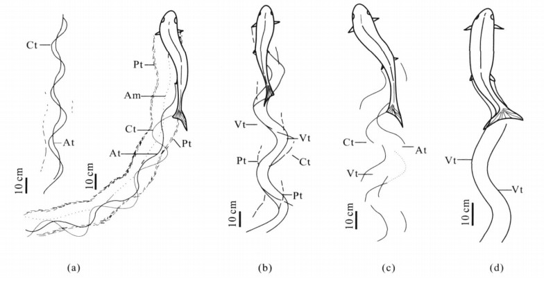
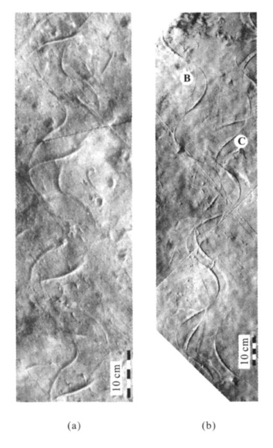
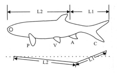
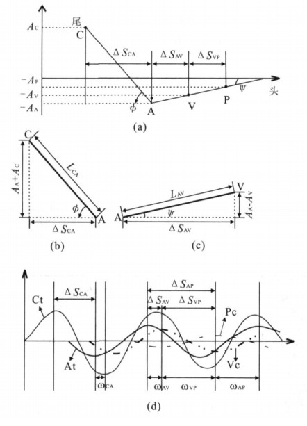
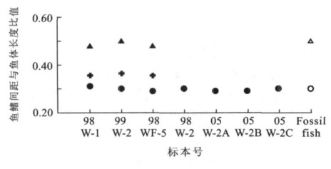
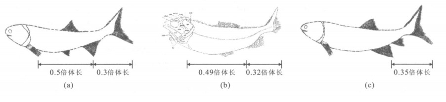
It is a palaeoichnological puzzle to restore the biological morphology of the trails makers by analyzing trace fossils. Many intact fish swimming trail fossils, which can reflect some biologic features of the trace-maker fish, such as body length, distribution of fish fins, shape and structure of fish fins, have been unearthed recent years from the Late Triassic of Hengshan County, Shaanxi Province. The mathematical formulations based on the analysis of the relationship between the morphological feature parameters of trace and trace producers indicate that, the certain ratio of the distance of fish fins and body length is consistent with that of modern fish. The result of the calculation of the data from fish swimming traces shows that, the trace Undichna britannica was made by these fishes, whose distance between caudal fin and anal fin is 0. 3 of the body length, the distance between anal fin and pectoral fins is 0. 5 of the body length, and the distance between caudal fin and ventral fins is between 0. 49-0. 5 of the body length. These features are consistent with the those of a fossil fish, named Wayaobulepis zichangensia sp. nov. in the stratum in close proximity to the trace fossil. The ratio of the distance between caudal fin and anal fin, resulted from the other trace Undichna tricosta, is about 0. 35, which is similar with the features of the fossil fish named Saurichthys huanshenensis in the same stratum.
It is a palaeoichnological puzzle to restore the biological morphology of the trails makers by analyzing trace fossils. Many intact fish swimming trail fossils, which can reflect some biologic features of the trace-maker fish, such as body length, distribution of fish fins, shape and structure of fish fins, have been unearthed recent years from the Late Triassic of Hengshan County, Shaanxi Province. The mathematical formulations based on the analysis of the relationship between the morphological feature parameters of trace and trace producers indicate that, the certain ratio of the distance of fish fins and body length is consistent with that of modern fish. The result of the calculation of the data from fish swimming traces shows that, the trace Undichna britannica was made by these fishes, whose distance between caudal fin and anal fin is 0. 3 of the body length, the distance between anal fin and pectoral fins is 0. 5 of the body length, and the distance between caudal fin and ventral fins is between 0. 49-0. 5 of the body length. These features are consistent with the those of a fossil fish, named Wayaobulepis zichangensia sp. nov. in the stratum in close proximity to the trace fossil. The ratio of the distance between caudal fin and anal fin, resulted from the other trace Undichna tricosta, is about 0. 35, which is similar with the features of the fossil fish named Saurichthys huanshenensis in the same stratum.
2008, 33(1): 19-25.
Abstract:
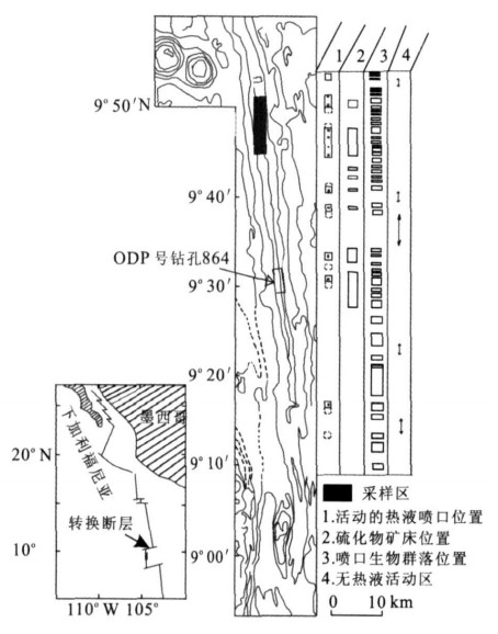
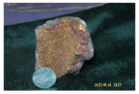
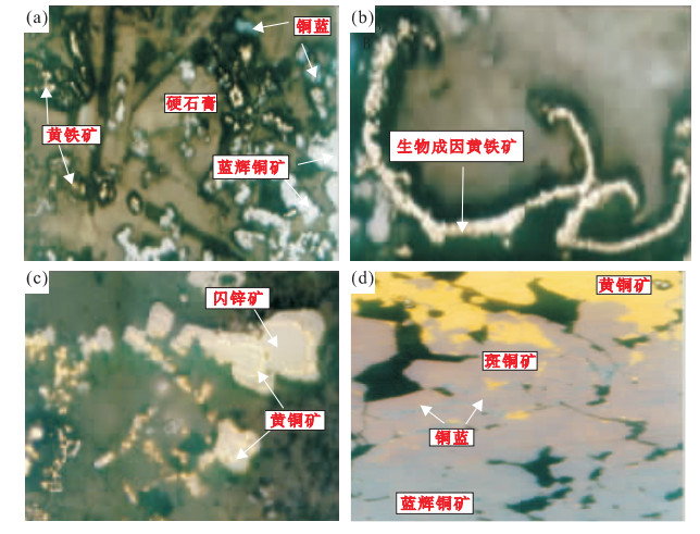
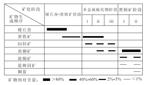
To characterize the hydrothermal processes of East Pacific rise at 9°-10°N, sulfide mineral compositions, textural and geochemical features of chimney ores were studied using ore microscope, scanning electron microscope, X-ray diffraction analysis, and electron microprobe techniques.Resultsshow that there are three mineral assemblages for the hydrothermal chimney ores, namely: (1) anhydrite + marcasite + pyrite, (2) pyrite + sphalerite + chalcopyrite, and (3) chalcopyrite + bornite + digenite + covellite. Mineral assemblages, zonational features, and geochemical characteristics of the ore minerals indicate that ore fluid temperature changed from low to high then to low with a maximum temperature up to 400 ℃. The chimney is a typical black smoker. The initial structure of the chimney was formed by the precipitation of anhydrites, and later the sulfides began to precipitate in the inner wall.
To characterize the hydrothermal processes of East Pacific rise at 9°-10°N, sulfide mineral compositions, textural and geochemical features of chimney ores were studied using ore microscope, scanning electron microscope, X-ray diffraction analysis, and electron microprobe techniques.Resultsshow that there are three mineral assemblages for the hydrothermal chimney ores, namely: (1) anhydrite + marcasite + pyrite, (2) pyrite + sphalerite + chalcopyrite, and (3) chalcopyrite + bornite + digenite + covellite. Mineral assemblages, zonational features, and geochemical characteristics of the ore minerals indicate that ore fluid temperature changed from low to high then to low with a maximum temperature up to 400 ℃. The chimney is a typical black smoker. The initial structure of the chimney was formed by the precipitation of anhydrites, and later the sulfides began to precipitate in the inner wall.
2008, 33(1): 26-34.
Abstract:
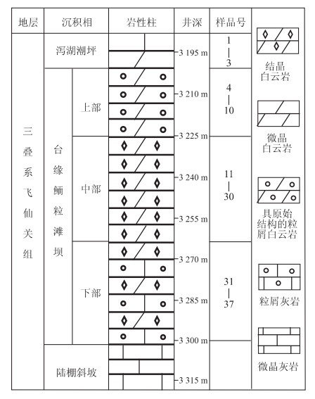
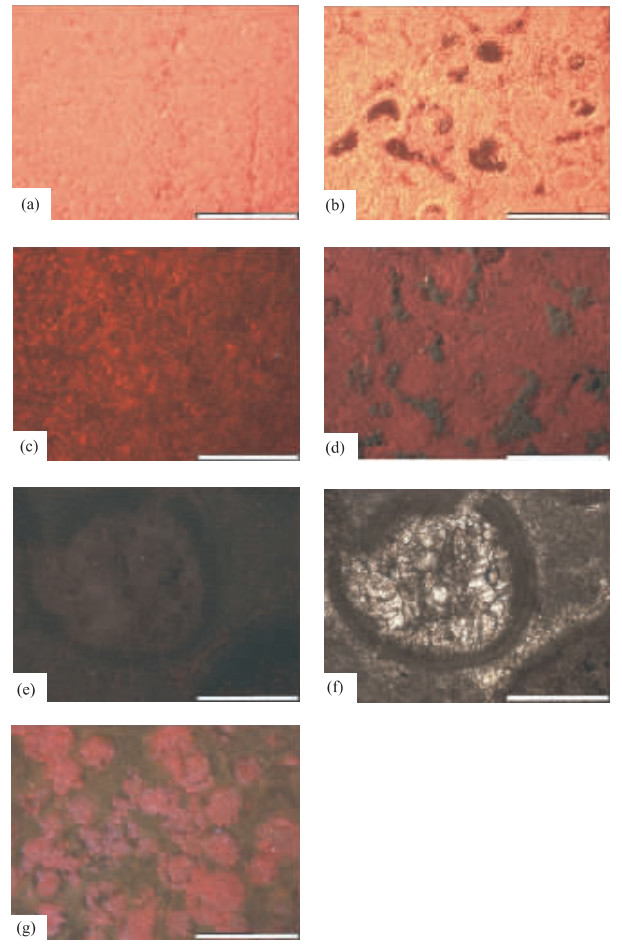
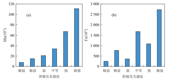
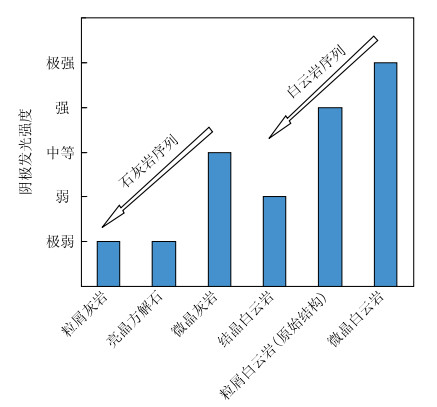
The Feixianguan carbonates of Triassic in Eastern Sichuan basin are the most important gas reservoir of China, and the reservoir with higher porosity and permeability is all dolomites, so the diagenesis, specially origin of dolomites is drawing increasing attention of petroleum geologists and sedmentologists. 42 carbonate samples, from Feixianguan Formation, Luojiazhai Gas Field of Eastern Sichuan basin, were studied by cathodoluminoscope. The results, together with the petrology analysis and Mn, Fe, Mg element tests, show that the carbonate rocks in Feixianguan Formation of Triassic, Eastern Sichuan basin of China generally have dull cathodoluminescence, which results from very low Mn and Fe contents, suggesting the limited influence of non-marine fluid during post-sedimentation. The diagenesis of the carbonates should have been governed by some kinds of marine fluid. However, the limestones and dolomites with different structures also display various cathodoluminescent intensities. The carbonates with more diagenetic components luminesce duller, in other words, the carbonates influenced by more post-sedimentary fluids (mainly pore waters) luminesce dull, suggesting the enhancement of marine fluid effect with the process of burial diagenesis. The cathodoluminescence of crystalline dolomite, which is the most important gas reservoir, reflects the deep burial conditions of diagenetic fluids that have not circulated through clastic rocks within the basin, but through some marine beds such as thick evaporates which are widely distributed in the Triassic of Sichuan basin. The dissolution or dehydration of evaporates provided the marine fluid that participated in the dolomitization of crystalline dolomite.
The Feixianguan carbonates of Triassic in Eastern Sichuan basin are the most important gas reservoir of China, and the reservoir with higher porosity and permeability is all dolomites, so the diagenesis, specially origin of dolomites is drawing increasing attention of petroleum geologists and sedmentologists. 42 carbonate samples, from Feixianguan Formation, Luojiazhai Gas Field of Eastern Sichuan basin, were studied by cathodoluminoscope. The results, together with the petrology analysis and Mn, Fe, Mg element tests, show that the carbonate rocks in Feixianguan Formation of Triassic, Eastern Sichuan basin of China generally have dull cathodoluminescence, which results from very low Mn and Fe contents, suggesting the limited influence of non-marine fluid during post-sedimentation. The diagenesis of the carbonates should have been governed by some kinds of marine fluid. However, the limestones and dolomites with different structures also display various cathodoluminescent intensities. The carbonates with more diagenetic components luminesce duller, in other words, the carbonates influenced by more post-sedimentary fluids (mainly pore waters) luminesce dull, suggesting the enhancement of marine fluid effect with the process of burial diagenesis. The cathodoluminescence of crystalline dolomite, which is the most important gas reservoir, reflects the deep burial conditions of diagenetic fluids that have not circulated through clastic rocks within the basin, but through some marine beds such as thick evaporates which are widely distributed in the Triassic of Sichuan basin. The dissolution or dehydration of evaporates provided the marine fluid that participated in the dolomitization of crystalline dolomite.
2008, 33(1): 35-45.
Abstract:
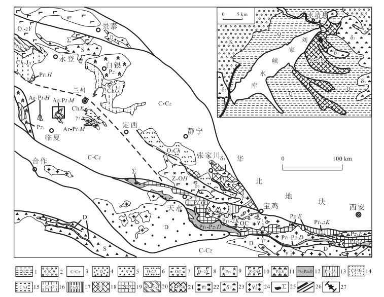
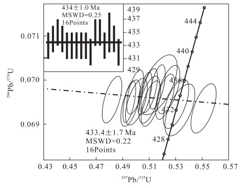
A large number of basic dikes which indicate an important tectonic-magmatic event in the eastern part of the middle Qilian orogenic belt were found in the Maxianshan rock group, Yongjing County, Gansu Province, China. According to research on their characteristics of geology and petrology, basic dike swarms, widely intruded in Maxianshan rock group, are divided into two phases. U-Pb isotopes of zircons from the basic dikes of the two phases were determined by LA-ICP-MS respectively in the State Key Laboratory of Continental Dynamics of Northwest University, and the causes of formation of the zircons were studied by using CL images. The formation age of the earlier phase of variational gabbro dikes is(441.1± 1.4) Ma(corresponding to the early stage of Early Silurian), and the age of main metamorphic period is(414.3± 1.2)Ma(corresponding to the early stage of Early Devonian). The formation age of the later phase of diabase dike swarms is(434± 1.0) Ma(corresponding to the late stage of Early Silurian), and the age of main metamorphic period is(414.3± 1.2)Ma(corresponding to the early stage of Early Devonian). The captured-zircons from diabase dike swarms retain some information of material interfusion by Maxiashan rock group(207Pb/206Pb apparent ages are(2 325± 3)Ma-(2 573± 6)Ma), and some zircons from diabase dike swarms also retain information impacted by tectonic thermal event during the late period of Caledonian Movement(206Pb/238U apparent ages are(400± 2)Ma-(429± 2)Ma). The study, together with others, suggests that, the basic dikes within Maxianshan rock group formed in the period when Qilian transferred from subductional orogeny towards collisional orogeny, which is the geological record of NW-SE extension during regional NE-SW toward intense compression in the Central Qilian block.
A large number of basic dikes which indicate an important tectonic-magmatic event in the eastern part of the middle Qilian orogenic belt were found in the Maxianshan rock group, Yongjing County, Gansu Province, China. According to research on their characteristics of geology and petrology, basic dike swarms, widely intruded in Maxianshan rock group, are divided into two phases. U-Pb isotopes of zircons from the basic dikes of the two phases were determined by LA-ICP-MS respectively in the State Key Laboratory of Continental Dynamics of Northwest University, and the causes of formation of the zircons were studied by using CL images. The formation age of the earlier phase of variational gabbro dikes is(441.1± 1.4) Ma(corresponding to the early stage of Early Silurian), and the age of main metamorphic period is(414.3± 1.2)Ma(corresponding to the early stage of Early Devonian). The formation age of the later phase of diabase dike swarms is(434± 1.0) Ma(corresponding to the late stage of Early Silurian), and the age of main metamorphic period is(414.3± 1.2)Ma(corresponding to the early stage of Early Devonian). The captured-zircons from diabase dike swarms retain some information of material interfusion by Maxiashan rock group(207Pb/206Pb apparent ages are(2 325± 3)Ma-(2 573± 6)Ma), and some zircons from diabase dike swarms also retain information impacted by tectonic thermal event during the late period of Caledonian Movement(206Pb/238U apparent ages are(400± 2)Ma-(429± 2)Ma). The study, together with others, suggests that, the basic dikes within Maxianshan rock group formed in the period when Qilian transferred from subductional orogeny towards collisional orogeny, which is the geological record of NW-SE extension during regional NE-SW toward intense compression in the Central Qilian block.


2008, 33(1): 46-56.
Abstract:
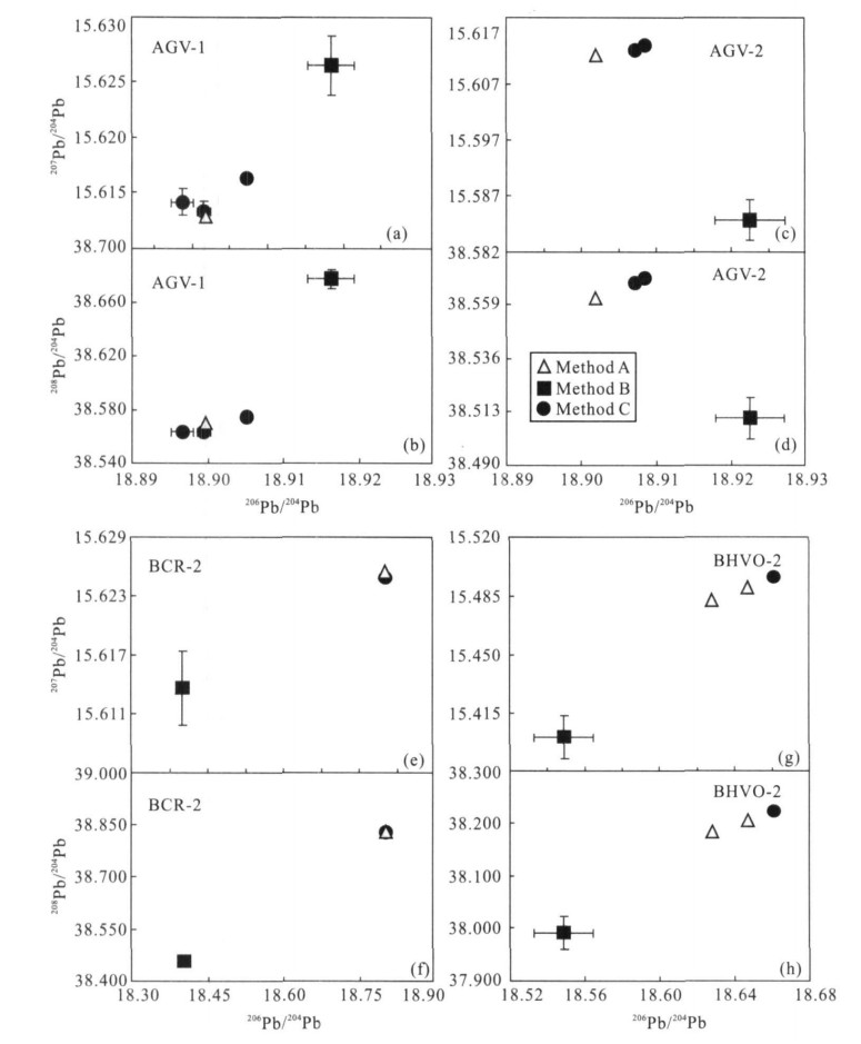
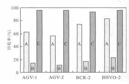
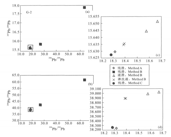
We present a simplified acid leaching method for lead isotope analysis of geological samples using multiple-collector inductively-coupled-plasma mass-spectrometry (MC-ICP-MS), to remove any contamination during sample preparation. The method is featured with higher throughput, and lower lead background using one step of weak hydrochloric acid leaching. Lead isotopic compositions of five United States Geological Survey (USGS) reference materials (AGV-1, AGV-2, BHVO-2, BCR-2, and G-2) were measured. The results show that both generations of USGS standards were contaminated during sample preparation. The grinding procedure and crushing environment were the dominating sources of contamination for the first and the second generations, respectively. The homogeneous lead isotopic compositions of these standards demonstrate that the one-step weak acid leaching is efficient and necessary for obtaining reliable lead isotope compositions in geological samples.
We present a simplified acid leaching method for lead isotope analysis of geological samples using multiple-collector inductively-coupled-plasma mass-spectrometry (MC-ICP-MS), to remove any contamination during sample preparation. The method is featured with higher throughput, and lower lead background using one step of weak hydrochloric acid leaching. Lead isotopic compositions of five United States Geological Survey (USGS) reference materials (AGV-1, AGV-2, BHVO-2, BCR-2, and G-2) were measured. The results show that both generations of USGS standards were contaminated during sample preparation. The grinding procedure and crushing environment were the dominating sources of contamination for the first and the second generations, respectively. The homogeneous lead isotopic compositions of these standards demonstrate that the one-step weak acid leaching is efficient and necessary for obtaining reliable lead isotope compositions in geological samples.

2008, 33(1): 57-60.
Abstract:
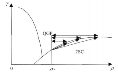
The fireball model is universally accepted as the standard model in explaining γ-ray bursts.Phase transition of strange stars is one of the factors leading to fireball appearance, which not only can explain the short scales and high energy of γ-ray bursts, but also address the issue of baryon pollution of the fireball. On the basis of researching the energy mecha- nism of gamma-ray bursts, the possibility that the energy of gamma-ray bursts at cosmology distance(~ Gpc)comes from phase transition of strange stars is discussed.
The fireball model is universally accepted as the standard model in explaining γ-ray bursts.Phase transition of strange stars is one of the factors leading to fireball appearance, which not only can explain the short scales and high energy of γ-ray bursts, but also address the issue of baryon pollution of the fireball. On the basis of researching the energy mecha- nism of gamma-ray bursts, the possibility that the energy of gamma-ray bursts at cosmology distance(~ Gpc)comes from phase transition of strange stars is discussed.
2008, 33(1): 61-66.
Abstract:
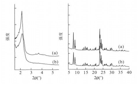
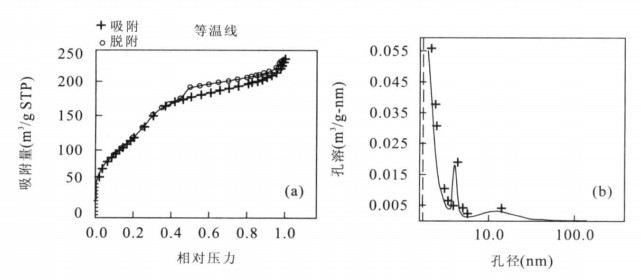
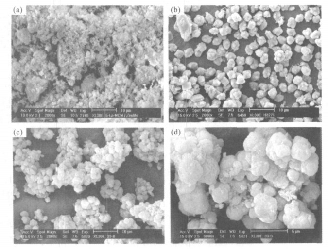
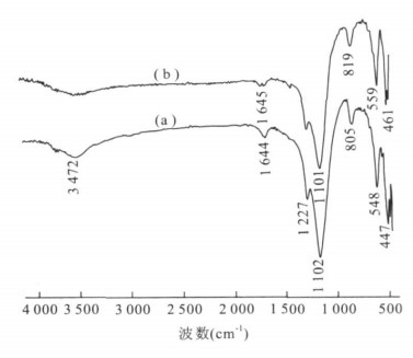
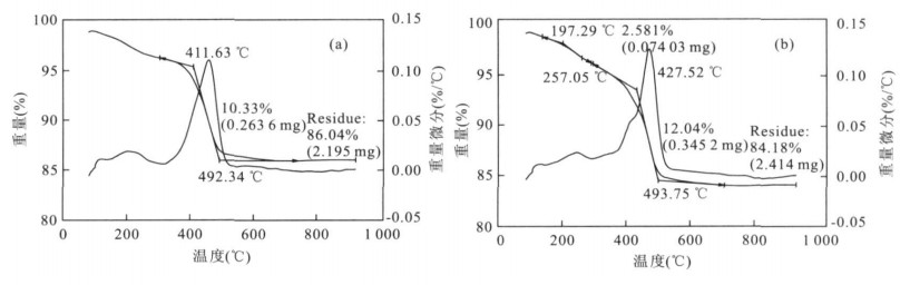
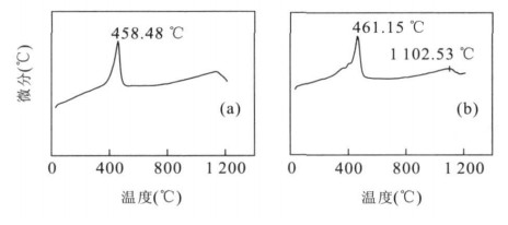
A ZSM-5/MCM-41 meso/microporous composite molecular sieve incorporated by lanthanum, noted as La-ZSM-5/MCM-41, was first synthesized under hydrothermal condition using sodium silicate (Na2SiO3) and aluminium sulphate (Al2(SO4)3) as Si and Al sources, sulfurate solution of lanthanum oxide (La2O3) as La supply and cetyltrimethyammonium bromide (CTMABr) and tetrepropylammonium bromide (TPABr) as mesoporous and microporous templates. There are several main procedures performed during the synthetic process, involving the introduction of rare earth La, the addition of ZSM-5 seed crystal and the two-step crystallization. The composite was characterized by means of XRD, N2 adsorption, SEM, IR, TG-DTG and DTA. The results of XRD and N2 adsorption measurement indicate that the synthetic sample possesses a composite phase containing mesoporous MCM-41 structure and microporous ZSM-5 structure, a dual pore structure whose pore size distribution lies respectively in mesoporous and microporous region, and rare earth La can replace Si existing in the framework of the composite sample. SEM micrograph of La-ZSM-5/MCM-41 sample shows the nonuniform agglomerates assembled by many spherical particles of different sizes closely combined with each other, which differ greatly in the morphology from pure ZSM-5 and MCM-41 molecular sieves. Moreover, the characteristic absorbing bands of La2O3 cannot be seen in La-ZSM-5/MCM-41 sample′s IR spectra. In comparison with that of ZSM-5/MCM-41 composite, La-ZSM-5/MCM-41 sample′s main IR vibrational peaks vary to low wavenumber and its weight loss peaks also shift to high temperature as well as a new and light exothermic peak appears in its DTA curve. All these phenomena demonstrate the replacement between Si in the framework of ZSM-5/MCM-41 composite and rare earth La, and prove the successful synthesis of ZSM-5/MCM-41 composite molecular sieve incorporated by rare earth La.
A ZSM-5/MCM-41 meso/microporous composite molecular sieve incorporated by lanthanum, noted as La-ZSM-5/MCM-41, was first synthesized under hydrothermal condition using sodium silicate (Na2SiO3) and aluminium sulphate (Al2(SO4)3) as Si and Al sources, sulfurate solution of lanthanum oxide (La2O3) as La supply and cetyltrimethyammonium bromide (CTMABr) and tetrepropylammonium bromide (TPABr) as mesoporous and microporous templates. There are several main procedures performed during the synthetic process, involving the introduction of rare earth La, the addition of ZSM-5 seed crystal and the two-step crystallization. The composite was characterized by means of XRD, N2 adsorption, SEM, IR, TG-DTG and DTA. The results of XRD and N2 adsorption measurement indicate that the synthetic sample possesses a composite phase containing mesoporous MCM-41 structure and microporous ZSM-5 structure, a dual pore structure whose pore size distribution lies respectively in mesoporous and microporous region, and rare earth La can replace Si existing in the framework of the composite sample. SEM micrograph of La-ZSM-5/MCM-41 sample shows the nonuniform agglomerates assembled by many spherical particles of different sizes closely combined with each other, which differ greatly in the morphology from pure ZSM-5 and MCM-41 molecular sieves. Moreover, the characteristic absorbing bands of La2O3 cannot be seen in La-ZSM-5/MCM-41 sample′s IR spectra. In comparison with that of ZSM-5/MCM-41 composite, La-ZSM-5/MCM-41 sample′s main IR vibrational peaks vary to low wavenumber and its weight loss peaks also shift to high temperature as well as a new and light exothermic peak appears in its DTA curve. All these phenomena demonstrate the replacement between Si in the framework of ZSM-5/MCM-41 composite and rare earth La, and prove the successful synthesis of ZSM-5/MCM-41 composite molecular sieve incorporated by rare earth La.
2008, 33(1): 67-73.
Abstract:
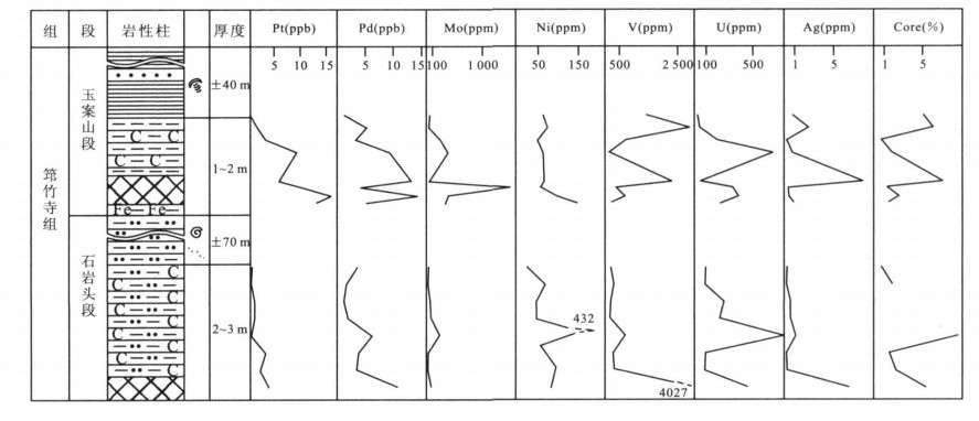
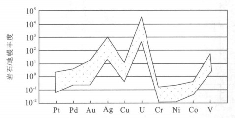
The Qiongzhusi Formation black shale series of the Deze area are located in the western part of the Lower Cambrian black shale zone widely distributed along the southern margin of the Yangtze block, SW China. Different from the Niutitang Formation of black shale in Hunan and Guizhou provinces, the Qiongzhusi Formation contains two distinct metal-rich layers, with V, U, Ag and Pd enriched in the bottom of black carbonaceous siltstones of the lower Shiyantou Section, and Mo, Ni, Pt and Pd in the bottom of black shales of the Yu'anshan Section. In general, the Qiongzhusi Formation is characterized by the enrichment of V-Ni-Mo-U-Ag-Pt-Pd assemblages, whereas the Niutitang Formation is featured with the enrichment of Ni-Zn-Co-Pt-Pd-Ag-Pb association. However, both areas share similar depositional and diagenetic environment (oxegen-reduction) and have similar mechanism for Ni-Mo-PGE mineralization. Ni-Mo-V-PGE mineralization in black shale series is an unconventional type of mineral resources, and it is of great importance to the deposit study and mineral exploitation.
The Qiongzhusi Formation black shale series of the Deze area are located in the western part of the Lower Cambrian black shale zone widely distributed along the southern margin of the Yangtze block, SW China. Different from the Niutitang Formation of black shale in Hunan and Guizhou provinces, the Qiongzhusi Formation contains two distinct metal-rich layers, with V, U, Ag and Pd enriched in the bottom of black carbonaceous siltstones of the lower Shiyantou Section, and Mo, Ni, Pt and Pd in the bottom of black shales of the Yu'anshan Section. In general, the Qiongzhusi Formation is characterized by the enrichment of V-Ni-Mo-U-Ag-Pt-Pd assemblages, whereas the Niutitang Formation is featured with the enrichment of Ni-Zn-Co-Pt-Pd-Ag-Pb association. However, both areas share similar depositional and diagenetic environment (oxegen-reduction) and have similar mechanism for Ni-Mo-PGE mineralization. Ni-Mo-V-PGE mineralization in black shale series is an unconventional type of mineral resources, and it is of great importance to the deposit study and mineral exploitation.

2008, 33(1): 74-82.
Abstract:
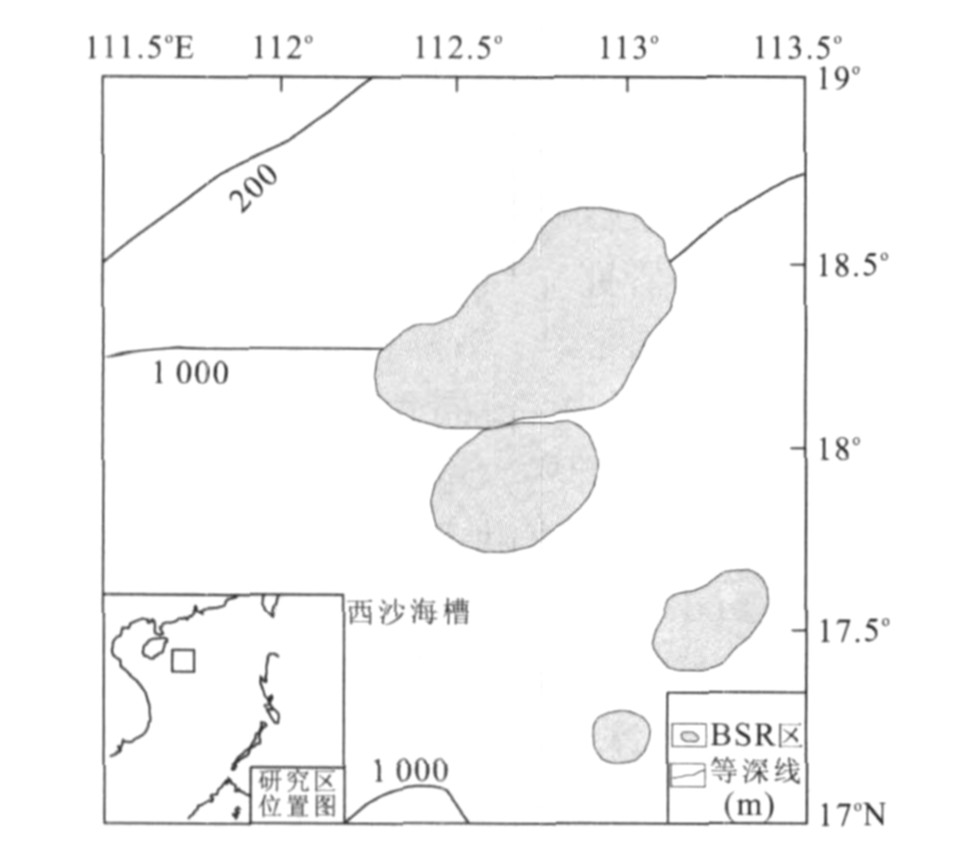
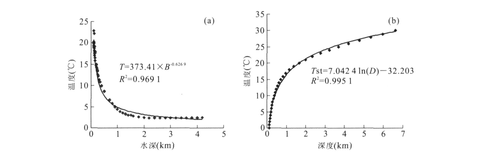
In this article, Milkov and Sassen's model is selected to calculate the thickness of the gas hydrate stable zone (GHSZ) and the amount of gas hydrate in the Xisha Trough at present and at the last glacial maximum (LGM), respectively, and the effects of the changes in the bottom water temperature and the sea level on these were also discussed. The average thickness of the GHSZ in Xisha Trough is estimated to be 287 m and 299 m based on the relationship between the GHSZ thickness and the water depth established in this study at present and at LGM, respectively. Then, by assuming that the distributed area of gas hydrates is 8 000 km2 and that the gas hydrate saturation is 1.2% of the sediment volume, the amounts of gas hydrate are estimated to be ~2.76×10¹⁰ m3 and ~2.87×10¹⁰ m3, and the volumes of hydrate-bound gases are ~4.52×10¹² m3 and ~4.71×10¹² m3 at present and at LGM, respectively. The above results show that the thickness of GHSZ decreases with the bottom water temperature increase and increases with the sea level increase, wherein the effect of the former is larger than that of the latter, that the average thickness of GHSZ in Xisha Trough had been reduced by ~12 m, and that 1.9×10¹¹ m3 of methane is released from approximately 1.1×10⁹ m3 of gas hydrate since LGM. The released methane should have greatly affected the environment.
In this article, Milkov and Sassen's model is selected to calculate the thickness of the gas hydrate stable zone (GHSZ) and the amount of gas hydrate in the Xisha Trough at present and at the last glacial maximum (LGM), respectively, and the effects of the changes in the bottom water temperature and the sea level on these were also discussed. The average thickness of the GHSZ in Xisha Trough is estimated to be 287 m and 299 m based on the relationship between the GHSZ thickness and the water depth established in this study at present and at LGM, respectively. Then, by assuming that the distributed area of gas hydrates is 8 000 km2 and that the gas hydrate saturation is 1.2% of the sediment volume, the amounts of gas hydrate are estimated to be ~2.76×10¹⁰ m3 and ~2.87×10¹⁰ m3, and the volumes of hydrate-bound gases are ~4.52×10¹² m3 and ~4.71×10¹² m3 at present and at LGM, respectively. The above results show that the thickness of GHSZ decreases with the bottom water temperature increase and increases with the sea level increase, wherein the effect of the former is larger than that of the latter, that the average thickness of GHSZ in Xisha Trough had been reduced by ~12 m, and that 1.9×10¹¹ m3 of methane is released from approximately 1.1×10⁹ m3 of gas hydrate since LGM. The released methane should have greatly affected the environment.
2008, 33(1): 83-90.
Abstract:
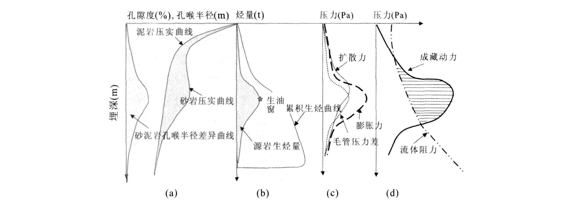
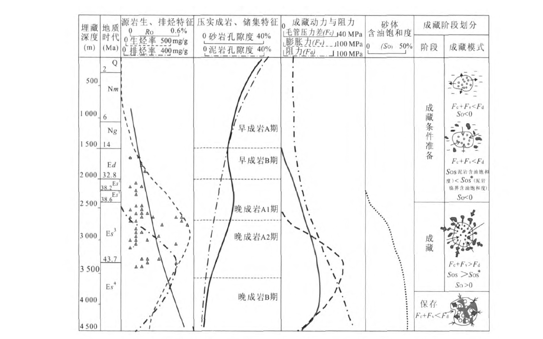
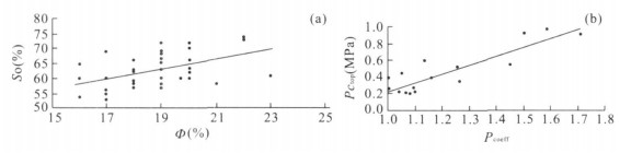
As the hotspot and emphasis of petroleum exploration in east China, sand lens reservoir plays an important role in the increase of petroleum reserve. Therefore, it is significant to do research on sand lens reservoir—its hydrocarbon accumulation mechanism, its quantitative evaluation and the forecast of its oil-bearing properties. Based on systematic analysis of hydrocarbon accumulation drive and resistance, we applied numerical simulation and geological statistics to construct geological model as well as mathematic model of hydrocarbon dynamics for sand lens reservoir, and to simulate hydrocarbon accumulation process. The research results show that major accumulation drive consists of capillary pressure difference between sandstone and mudstone, diffusion power resulted from hydrocarbon generation in mudstone and expansion power caused by hydrocarbon generation in mudstone. And the major accumulation resistance includes capillary pressure, sticky and absorption resistance in sandstone. The formation of lithologic reservoir in the Dongying depression was controlled by many factors including hydrocarbon expulsion intensity of mudstone, porosity and permeability of sandstone, buried depth, the ration of thickness of sandstone and thickness of mudstone. The formation of sand lens reservoir can be divided into several stages, and only at the late diagenesis stage, the accumulation drive was greater than the resistance and as a result hydrocarbon filled in sand lens, which shows there exists a threshold buried depth for sand lens. Based on hydrocarbon accumulation dynamics, the authors also constructed quantitative relation between accumulation dynamics and oil-bearing properties, which affords a good means to forecast saturation and its saturation distribution in plane of sand lens pool.
As the hotspot and emphasis of petroleum exploration in east China, sand lens reservoir plays an important role in the increase of petroleum reserve. Therefore, it is significant to do research on sand lens reservoir—its hydrocarbon accumulation mechanism, its quantitative evaluation and the forecast of its oil-bearing properties. Based on systematic analysis of hydrocarbon accumulation drive and resistance, we applied numerical simulation and geological statistics to construct geological model as well as mathematic model of hydrocarbon dynamics for sand lens reservoir, and to simulate hydrocarbon accumulation process. The research results show that major accumulation drive consists of capillary pressure difference between sandstone and mudstone, diffusion power resulted from hydrocarbon generation in mudstone and expansion power caused by hydrocarbon generation in mudstone. And the major accumulation resistance includes capillary pressure, sticky and absorption resistance in sandstone. The formation of lithologic reservoir in the Dongying depression was controlled by many factors including hydrocarbon expulsion intensity of mudstone, porosity and permeability of sandstone, buried depth, the ration of thickness of sandstone and thickness of mudstone. The formation of sand lens reservoir can be divided into several stages, and only at the late diagenesis stage, the accumulation drive was greater than the resistance and as a result hydrocarbon filled in sand lens, which shows there exists a threshold buried depth for sand lens. Based on hydrocarbon accumulation dynamics, the authors also constructed quantitative relation between accumulation dynamics and oil-bearing properties, which affords a good means to forecast saturation and its saturation distribution in plane of sand lens pool.
2008, 33(1): 91-96.
Abstract:
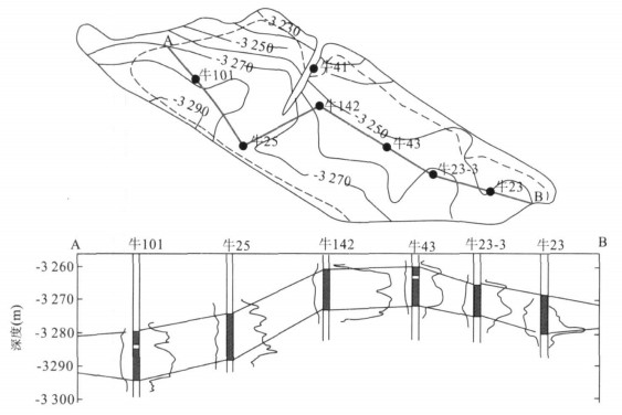
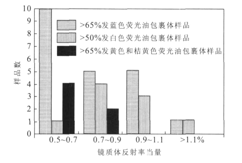
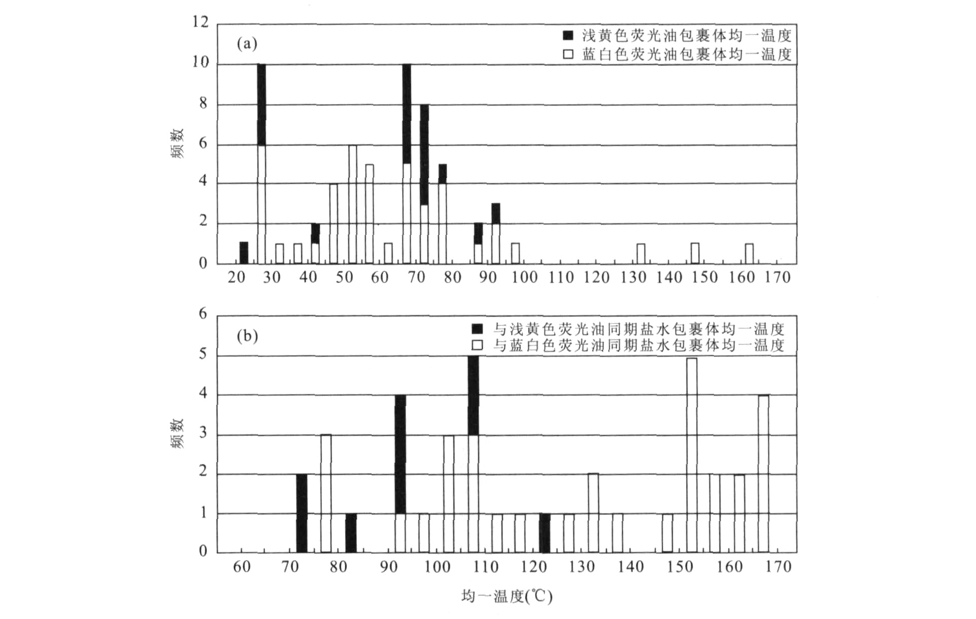
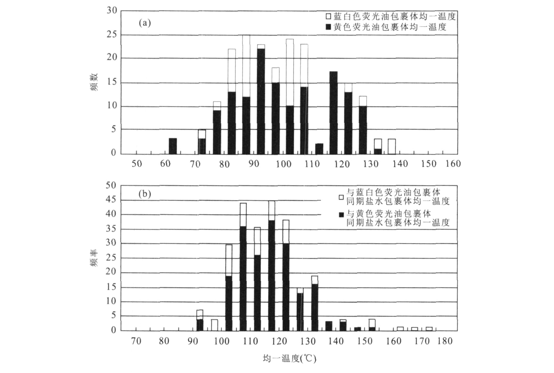
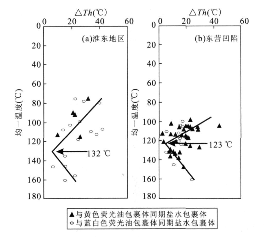
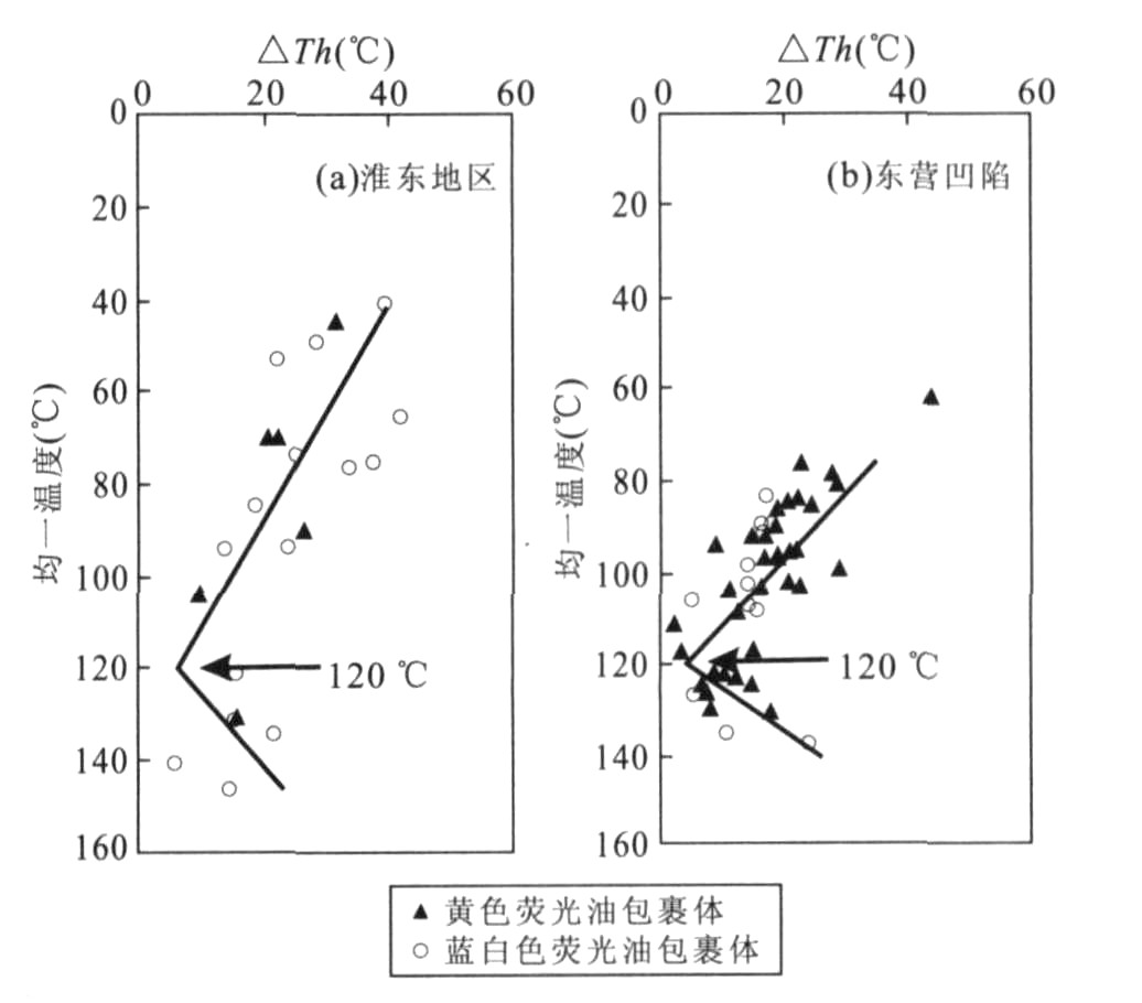
In recent years, organic inclusion technique has been extensively applied to petroleum exploration. The fluorescence is also a good measurement in identifying oil inclusions and an effective indicator of its maturity, except for some oil inclusions of lower homogenization temperature with white-blue fluorescence color which have been possibly caused by heating decomposition after trapping. In this study, many samples from two basins have been measured to obtain the fluorescence colors and the differences between homogenization temperatures of the coeval aqueous inclusion and oil inclusion, which proves that there is a positive relationship between the fluorescence colors and the averaged homogenization temperature of oil inclusions, and can be reliably used to indicate the hydrocarbon maturity in spite of the fact that some researchers think that it is dangerous to apply visual description of fluorescence colors to determine maturity of hydrocarbon.
In recent years, organic inclusion technique has been extensively applied to petroleum exploration. The fluorescence is also a good measurement in identifying oil inclusions and an effective indicator of its maturity, except for some oil inclusions of lower homogenization temperature with white-blue fluorescence color which have been possibly caused by heating decomposition after trapping. In this study, many samples from two basins have been measured to obtain the fluorescence colors and the differences between homogenization temperatures of the coeval aqueous inclusion and oil inclusion, which proves that there is a positive relationship between the fluorescence colors and the averaged homogenization temperature of oil inclusions, and can be reliably used to indicate the hydrocarbon maturity in spite of the fact that some researchers think that it is dangerous to apply visual description of fluorescence colors to determine maturity of hydrocarbon.
2008, 33(1): 97-106.
Abstract:
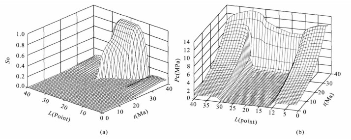
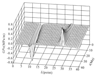
To find out the mechanism and controlling factors of the original lentoid sand reservoir, its oil-trapping process is numerically simulated on one dimensional condition based on the theory of two-phase fluid flow in compactable porous media, taking into account of its various related processes and parameters. It is ascertained that overpressure is the force of gross fluid flow out of the source rock rather than the force of oil accumulation in the lentoid sand reservoir. The fundamental force for oil accumulation in the lentoid sand reservoir is the difference of capillary pressures built up between the source rock and the reservoir. The potential of oil phase in lentoid sand reservoir is less than that in the surrounding source rock in the oiltrapping process. The oil trapping process of lentoid sand reservoir is controlled by the principles of potential balance and volume balance. The oil-bearing characteristics of the reservoir are determined by the oil volume provided and the oil phase potential difference between the source rock and the reservoir.
To find out the mechanism and controlling factors of the original lentoid sand reservoir, its oil-trapping process is numerically simulated on one dimensional condition based on the theory of two-phase fluid flow in compactable porous media, taking into account of its various related processes and parameters. It is ascertained that overpressure is the force of gross fluid flow out of the source rock rather than the force of oil accumulation in the lentoid sand reservoir. The fundamental force for oil accumulation in the lentoid sand reservoir is the difference of capillary pressures built up between the source rock and the reservoir. The potential of oil phase in lentoid sand reservoir is less than that in the surrounding source rock in the oiltrapping process. The oil trapping process of lentoid sand reservoir is controlled by the principles of potential balance and volume balance. The oil-bearing characteristics of the reservoir are determined by the oil volume provided and the oil phase potential difference between the source rock and the reservoir.
2008, 33(1): 107-111.
Abstract:
Though band ratio is highly evaluated as a single method in oil-gas exploration, the effect is far from satisfactory. To find a highly effective quantitative analysis method, in this paper, the bands 7, 5, 3 are chosen to extract structure information according to specific band characteristics of ETM+ (Enhanced Thematic Mapper Plus) data. Based on structure oil-controlling theory, a series of band ratios (such as 5/1, 7/5, 7/3, (7-5) / (7+5)) is compared. Then, the overlapping analysis of 7 band compositions (5, NDVI (the Normalized Difference Vegetation Index), 3, 5, 4, NDVI, 7, 5, 5/1, 7, 5, 7/1, 7, 5, 7/3, 7, 5, 7/5, 7, 5, (7-5) / (7+5)) are done through standard deviation, correlation coefficient, covariance, eigenvalue. Through the integrated interpretation and combined with geological structure information and geological data, 7, 5, 7 /3 is found to be the best band combination. With this combination method, the extracting of oil and gas halo information in Yakela region of Xinjiang produces satisfactory result, which proves its potential usage in other regions.
Though band ratio is highly evaluated as a single method in oil-gas exploration, the effect is far from satisfactory. To find a highly effective quantitative analysis method, in this paper, the bands 7, 5, 3 are chosen to extract structure information according to specific band characteristics of ETM+ (Enhanced Thematic Mapper Plus) data. Based on structure oil-controlling theory, a series of band ratios (such as 5/1, 7/5, 7/3, (7-5) / (7+5)) is compared. Then, the overlapping analysis of 7 band compositions (5, NDVI (the Normalized Difference Vegetation Index), 3, 5, 4, NDVI, 7, 5, 5/1, 7, 5, 7/1, 7, 5, 7/3, 7, 5, 7/5, 7, 5, (7-5) / (7+5)) are done through standard deviation, correlation coefficient, covariance, eigenvalue. Through the integrated interpretation and combined with geological structure information and geological data, 7, 5, 7 /3 is found to be the best band combination. With this combination method, the extracting of oil and gas halo information in Yakela region of Xinjiang produces satisfactory result, which proves its potential usage in other regions.


2008, 33(1): 112-116.
Abstract:
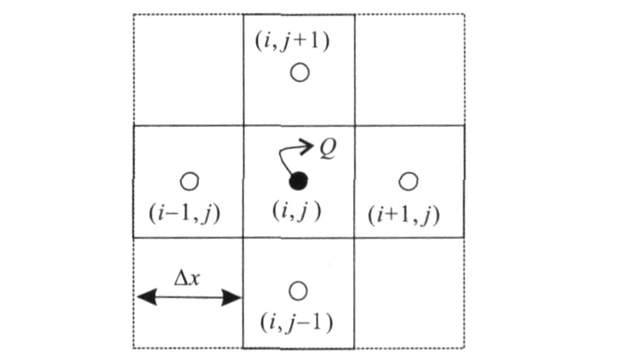
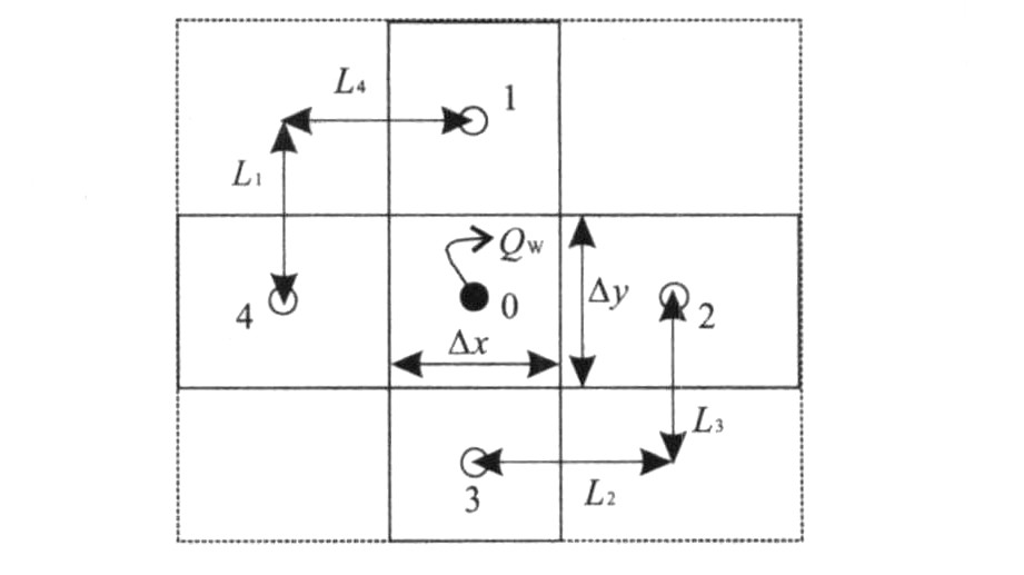
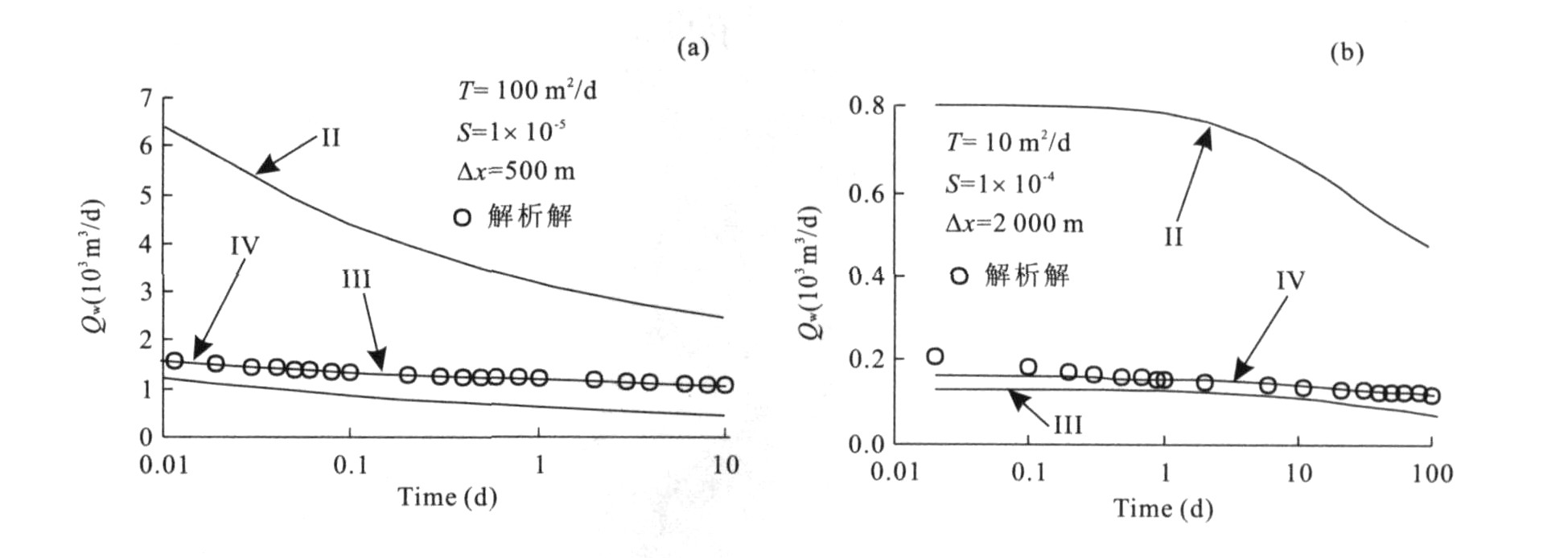
It is a typical hydrogeological phenomenon for flowing artesian wells occur in aquifer-well systems. However, these wells have been seldom analyzed in the models for assessment and management of groundwater resources. The three treatment methods of flowing artesian wells that applied currently in numerical modeling of groundwater flow are unreasonable and are not verified. It proves that conventional finite-difference method can neither give accurately the water table in a pumping well, nor the flow rate of a flowing artesian well. The calculated head or flow rate of well-element must be revised. Applying analytical method, a revised model of flowing artesian wells is developed for finite-difference grid with rectangle cells, taking into account of the radial flow in the vicinity of an artesian well, and the release of storage in the confined aquifer surrounding the artesian well. Examples indicate that this revised model of flowing artesian wells gives a significantly improved numerical result of flow rate, with average relative errors less than 5% even for 1 000-m-magnitude cell size.
It is a typical hydrogeological phenomenon for flowing artesian wells occur in aquifer-well systems. However, these wells have been seldom analyzed in the models for assessment and management of groundwater resources. The three treatment methods of flowing artesian wells that applied currently in numerical modeling of groundwater flow are unreasonable and are not verified. It proves that conventional finite-difference method can neither give accurately the water table in a pumping well, nor the flow rate of a flowing artesian well. The calculated head or flow rate of well-element must be revised. Applying analytical method, a revised model of flowing artesian wells is developed for finite-difference grid with rectangle cells, taking into account of the radial flow in the vicinity of an artesian well, and the release of storage in the confined aquifer surrounding the artesian well. Examples indicate that this revised model of flowing artesian wells gives a significantly improved numerical result of flow rate, with average relative errors less than 5% even for 1 000-m-magnitude cell size.
2008, 33(1): 117-123.
Abstract:
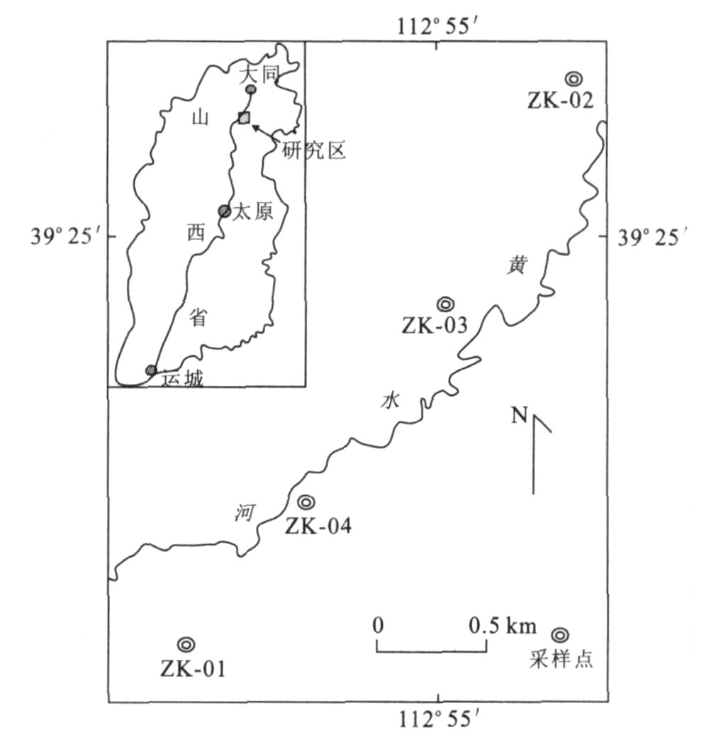
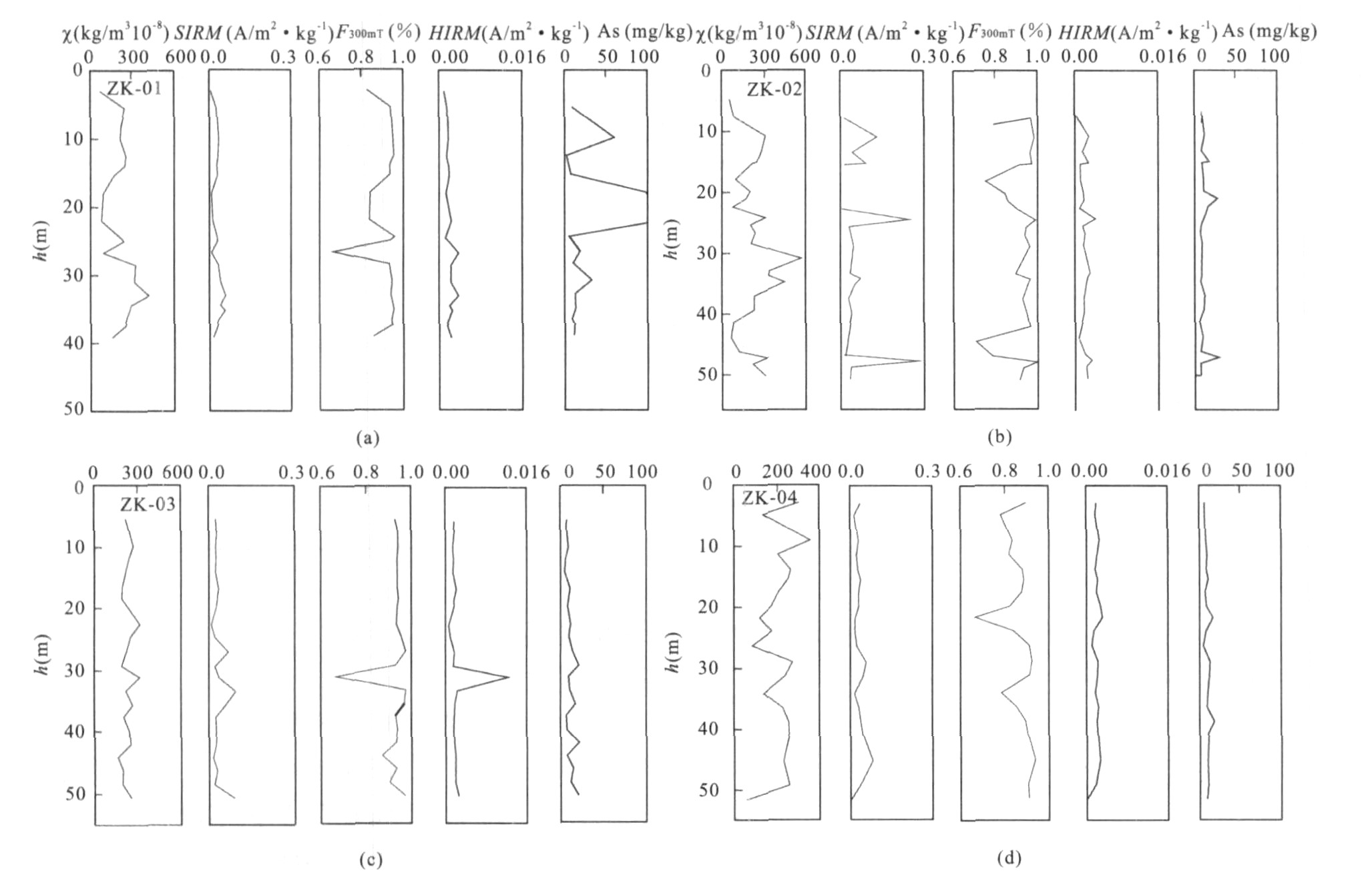
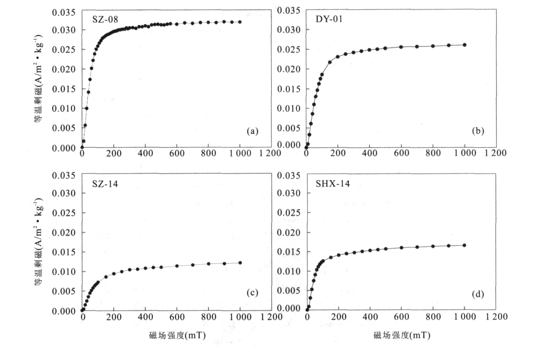
The purpose of the study is to test the possible relationship between magnetic parameters and arsenic in high arsenic aquifer sediment. Magnetic and geochemical study on core sediments from Datong basin suggests that the dominant magnetic mineral is ferrimagnetic. Magnetic measurements and arsenic concentration analysis were carried out to understand the distribution characteristics of magnetic parameters and arsenic in sediments. All core samples with high arsenic content have low saturation isothermal remnant magnetism (SIRM) values, indicating the correlation between arsenic and paramagnetic mineral. The correlation factors between arsenic content and magnetic parameters are very low (R2 < 0.5, α=0.05), but the magnetic susceptibility (χ) is better correlated than the other magnetic parameters with correlation factor of about 0.4 (α=0.05). The low correlation between magnetic proxies and arsenic content is attributed to the dilution of paramagnetic minerals by the ferrimagnetic and anti-ferromagnetic minerals. The occurrence of As-rich groundwater in this region may be due to dissolution of As-bearing Fe mineral (e.g. γFeOOH, 5Fe2O3·9H2O) and subsequent arsenic release.
The purpose of the study is to test the possible relationship between magnetic parameters and arsenic in high arsenic aquifer sediment. Magnetic and geochemical study on core sediments from Datong basin suggests that the dominant magnetic mineral is ferrimagnetic. Magnetic measurements and arsenic concentration analysis were carried out to understand the distribution characteristics of magnetic parameters and arsenic in sediments. All core samples with high arsenic content have low saturation isothermal remnant magnetism (SIRM) values, indicating the correlation between arsenic and paramagnetic mineral. The correlation factors between arsenic content and magnetic parameters are very low (R2 < 0.5, α=0.05), but the magnetic susceptibility (χ) is better correlated than the other magnetic parameters with correlation factor of about 0.4 (α=0.05). The low correlation between magnetic proxies and arsenic content is attributed to the dilution of paramagnetic minerals by the ferrimagnetic and anti-ferromagnetic minerals. The occurrence of As-rich groundwater in this region may be due to dissolution of As-bearing Fe mineral (e.g. γFeOOH, 5Fe2O3·9H2O) and subsequent arsenic release.
2008, 33(1): 124-130.
Abstract:
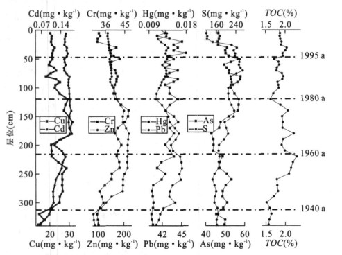
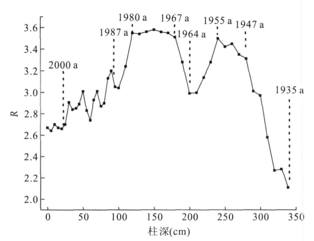
The contamination history of heavy metals and changes of the depositional environment of the West Harbour in Xiamen for the last 70 years were studied by using high resolution records, the measurement of concentrations of heavy metals, organic matters and sulfide in its marine sediment core, grain-size analysis, and recent sedimentation rate of the sediment. The results indicate that Cu, Zn, Pb, and As can be considered as indicators of anthropogenic metal pollution. The degree of enrichment is As > Cu > Zn > Pb, whereas Cr, Cd and Hg are not enriched in the sediment of the area. The variation of the sediment composition and depositional environment in the site has been obvious in the last 70 years. There is direct correlation among the vertical distribution characteristics of the heavy metals, hydrodynamic force and depositional environment of the time. For the sediment, the more stable of the source, and the smaller of the grain size and the better of the separation, the higher the content of heavy metals are in sediment. There is significant positive correlation between the concentrations of the most heavy metals and the concentrations of organic carbon and sulfide in all depth.
The contamination history of heavy metals and changes of the depositional environment of the West Harbour in Xiamen for the last 70 years were studied by using high resolution records, the measurement of concentrations of heavy metals, organic matters and sulfide in its marine sediment core, grain-size analysis, and recent sedimentation rate of the sediment. The results indicate that Cu, Zn, Pb, and As can be considered as indicators of anthropogenic metal pollution. The degree of enrichment is As > Cu > Zn > Pb, whereas Cr, Cd and Hg are not enriched in the sediment of the area. The variation of the sediment composition and depositional environment in the site has been obvious in the last 70 years. There is direct correlation among the vertical distribution characteristics of the heavy metals, hydrodynamic force and depositional environment of the time. For the sediment, the more stable of the source, and the smaller of the grain size and the better of the separation, the higher the content of heavy metals are in sediment. There is significant positive correlation between the concentrations of the most heavy metals and the concentrations of organic carbon and sulfide in all depth.

2008, 33(1): 131-136.
Abstract:
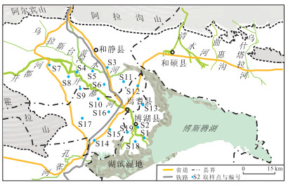
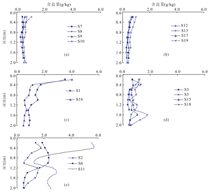
To understand the distribution pattern of salinity in soil profiles and factors influenced, soil samples were collected from irrigated areas of Yanqi basin and tested for total salinity and soil particle composition, and then the relationship between salinity and particle composition was studied using the Spearman rank correlation analysis. Based on the analysis, soil salinity profiles in the area are classified into three types: equably distribution profiles (EDP), surface accumulation profiles (SAP) and oscillation profiles (OP). EDP are featured with the lowest and equal distribution of salinity; SAP are characterized by the most obvious soil surface salinity accumulation (accumulation coefficient is 4.20), OP by the highest salinity and the largest coefficient of variation (82.4%). Silty loam is the most common textural class (70.8% in all soil samples) and silt is the highest particle-size fraction of soil samples (mean content is 57.1%). In EDP the correlation coefficient of salinity with clay content (0.560) is the highest, and the positive correlation of them is extremely significant. In OP the correlation coefficient of salinity with sand content (-0.639) is the highest, and the negative correlation of them is extremely significant. In SAP the salinity is not obviously correlated with soil particle composition. Considering the existing areas of EDP and OP, it is found that soil salinity is mainly affected by the clay content in the non-salinization area with relatively lower salinity and sand content, and whereas it is mainly affected by the sand content in the salinization area with relatively higher salinity and sand content.
To understand the distribution pattern of salinity in soil profiles and factors influenced, soil samples were collected from irrigated areas of Yanqi basin and tested for total salinity and soil particle composition, and then the relationship between salinity and particle composition was studied using the Spearman rank correlation analysis. Based on the analysis, soil salinity profiles in the area are classified into three types: equably distribution profiles (EDP), surface accumulation profiles (SAP) and oscillation profiles (OP). EDP are featured with the lowest and equal distribution of salinity; SAP are characterized by the most obvious soil surface salinity accumulation (accumulation coefficient is 4.20), OP by the highest salinity and the largest coefficient of variation (82.4%). Silty loam is the most common textural class (70.8% in all soil samples) and silt is the highest particle-size fraction of soil samples (mean content is 57.1%). In EDP the correlation coefficient of salinity with clay content (0.560) is the highest, and the positive correlation of them is extremely significant. In OP the correlation coefficient of salinity with sand content (-0.639) is the highest, and the negative correlation of them is extremely significant. In SAP the salinity is not obviously correlated with soil particle composition. Considering the existing areas of EDP and OP, it is found that soil salinity is mainly affected by the clay content in the non-salinization area with relatively lower salinity and sand content, and whereas it is mainly affected by the sand content in the salinization area with relatively higher salinity and sand content.
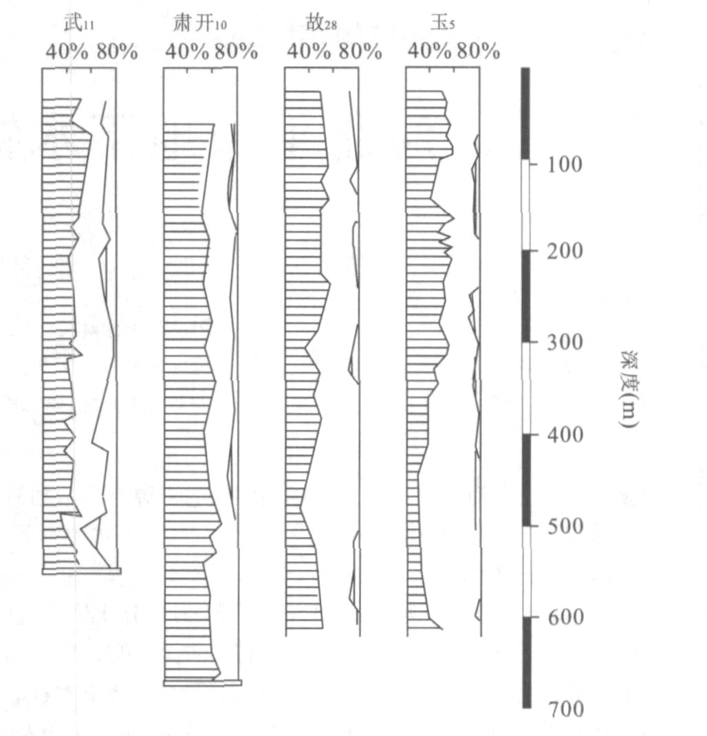
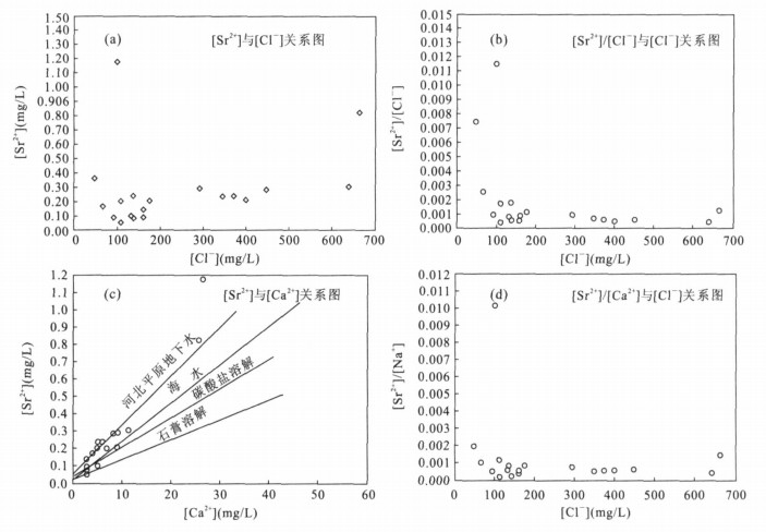
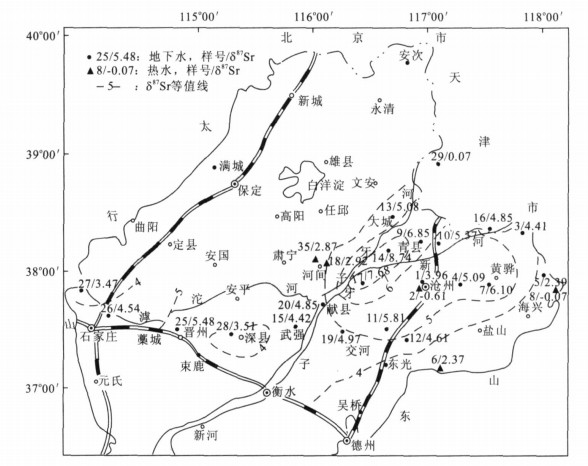
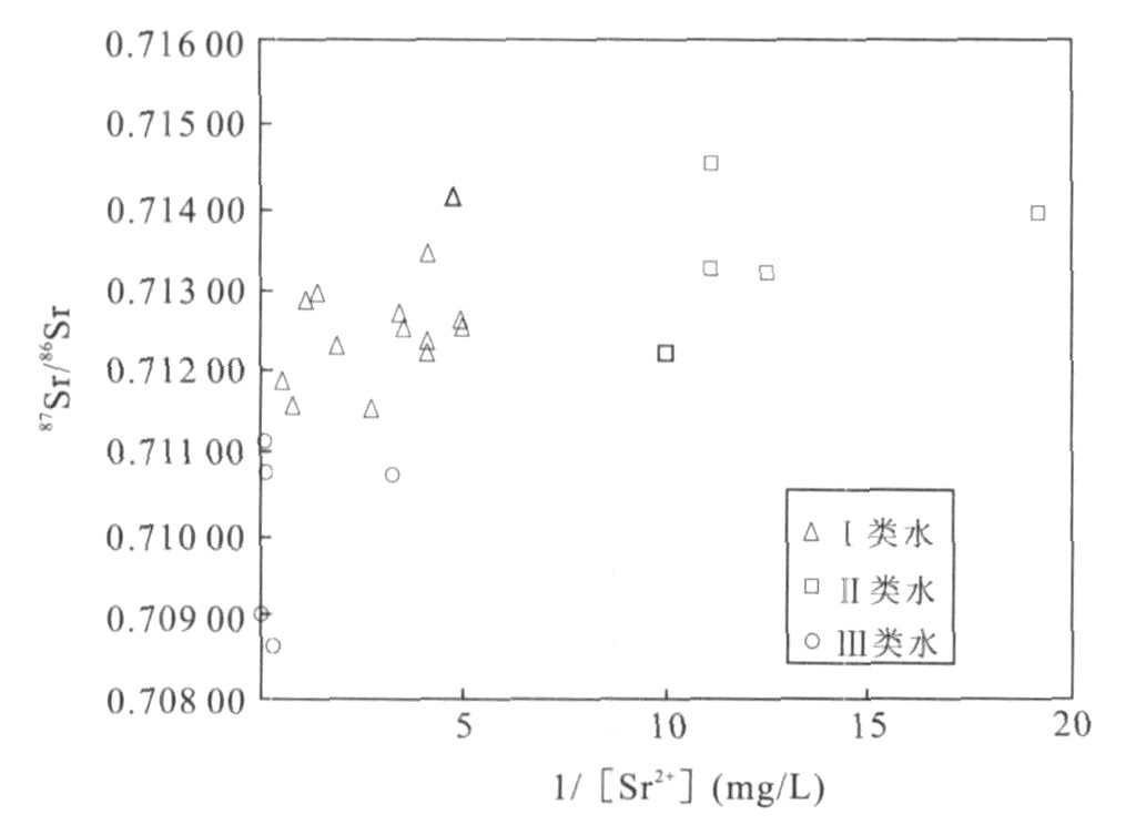
2008, 33(1): 137-144.
Abstract:
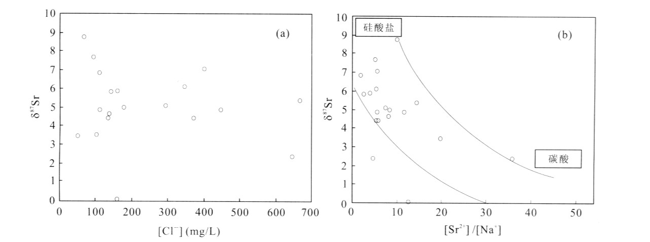
To analyze the genesis of Sr isotopes ingroundwater of Hebei plain, time-accumulative effect of 87Sr/86Sr ratios was studied. It is shown that 87Sr/86Sr ratio increases with the increasing age and depth of groundwater and has a positive correlation to 4Heexc and a negative correlation to δ18O and δD. The groundwater is divided into three groups to discuss the relation between 87Sr/86Sr ratio and Sr2+ content: (1) moderate Sr2+ content and higher 87Sr/86Sr (water I); (2) lower Sr2+content and higher 87Sr/86Sr (water Ⅱ); and (3) higher Sr2+ content and lower 87Sr/86Sr (water Ⅲ), that is hot water. On the basis of integrated analysis, it was considered that (1) the radiogenic Sr in the Quaternary groundwater (Q4-Q1) originates from weathering of silicate rich in Na and Rb, mainly from plagioclase; (2) the radiogenic Sr of hot water in Huanghua port is attributed to carbonate dissolution, with lower 87Sr/86Sr and higher Sr/Na; (3) the recharge area is laterally recharged by the groundwater flowing through igneous and metamorphic rocks, with moderate 87Sr/86Sr ratio. However, the genesis of Sr isotopes in Tertiary groundwater needs further studies.
To analyze the genesis of Sr isotopes ingroundwater of Hebei plain, time-accumulative effect of 87Sr/86Sr ratios was studied. It is shown that 87Sr/86Sr ratio increases with the increasing age and depth of groundwater and has a positive correlation to 4Heexc and a negative correlation to δ18O and δD. The groundwater is divided into three groups to discuss the relation between 87Sr/86Sr ratio and Sr2+ content: (1) moderate Sr2+ content and higher 87Sr/86Sr (water I); (2) lower Sr2+content and higher 87Sr/86Sr (water Ⅱ); and (3) higher Sr2+ content and lower 87Sr/86Sr (water Ⅲ), that is hot water. On the basis of integrated analysis, it was considered that (1) the radiogenic Sr in the Quaternary groundwater (Q4-Q1) originates from weathering of silicate rich in Na and Rb, mainly from plagioclase; (2) the radiogenic Sr of hot water in Huanghua port is attributed to carbonate dissolution, with lower 87Sr/86Sr and higher Sr/Na; (3) the recharge area is laterally recharged by the groundwater flowing through igneous and metamorphic rocks, with moderate 87Sr/86Sr ratio. However, the genesis of Sr isotopes in Tertiary groundwater needs further studies.