2025 Vol. 50, No. 12
Display Method:
2025, 50(12): 4583-4603.
doi: 10.3799/dqkx.2025.125
 PDF 14180KB
Abstract:
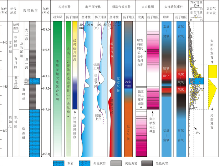
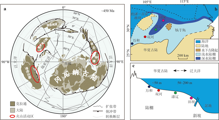
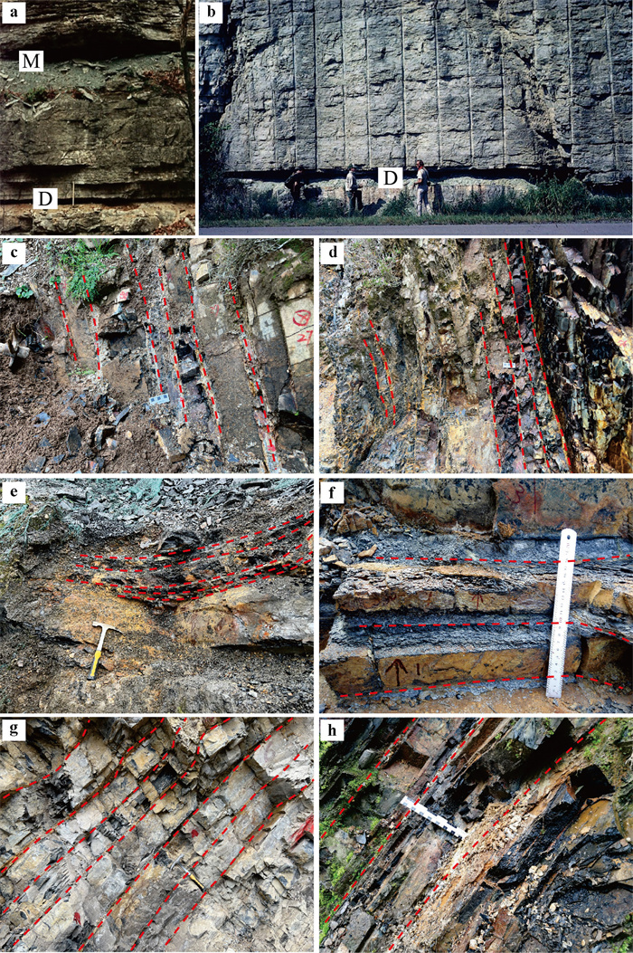
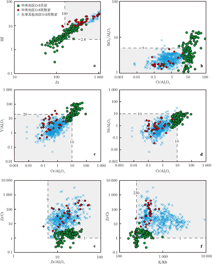
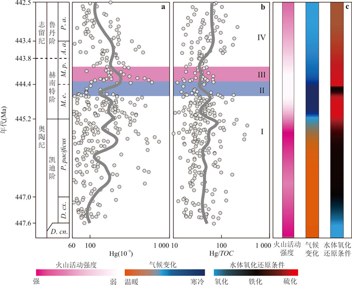
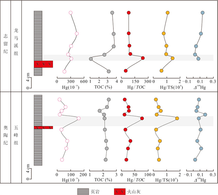
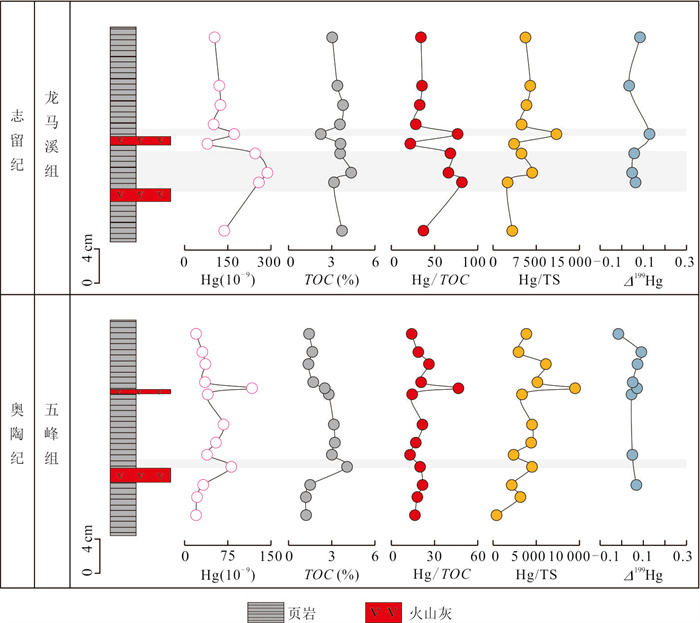
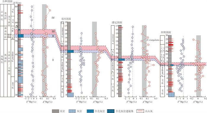
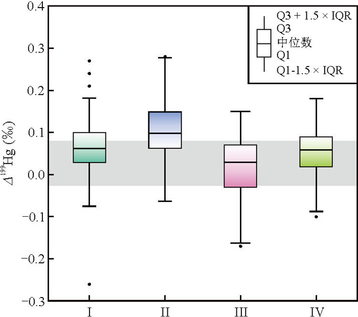
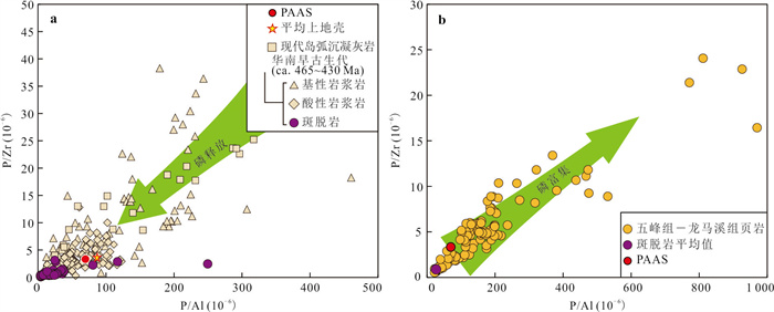
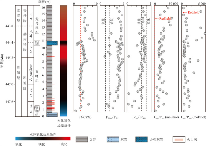
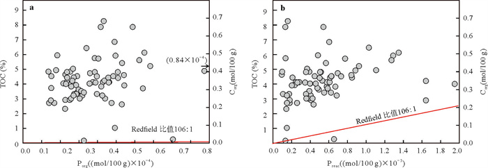
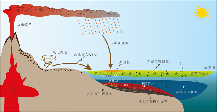
Large-scale volcanic activity is recognized as one of the critical drivers of global climate and environmental changes, as well as biodiversity fluctuations. It can enhance marine surface primary productivity and promote the development of euxinic bottom water conditions, thus facilitating organic-rich sedimentation. Across the Ordovician-Silurian transition, intense global volcanic activities coincided with the widespread deposition of black shales and the development of organic-rich intervals characterized by extraordinarily high total organic matter (TOC≥3.0%). Based on more than 800 samples, including TOC, major and trace elements, mercury (Hg) concentrations and Hg isotopes, collected from over 20 typical wells and sections of the Wufeng-Lungmachi formations in South China, this study discusses the occurrence and identification features of visible volcanic ash layers and highlights the application of major and trace elements, Hg concentrations and isotopes to identify cryptotephra. Furthermore, the impact of volcanic activity on marine environmental changes and the formation of extraordinarily high organic matter deposits were investigated. The results suggest follows. (1) The distribution of visible volcanic ash and cryptotephra provides a robust basis for reconstructing volcanic history of this period. (2) Elevated phosphorus inputs from volcanic activity enhanced marine surface primary productivity and expanded the extent of anoxic bottom water. (3) The anoxic conditions promoted phosphorus recycling, thereby sustaining high primary productivity. (4) Enhanced volcanic weathering increased sulfate input, which could further promote euxinic conditions. Sustained volcanic activities and their associated climate and environmental effects contributed to the high primary productivity and euxinic conditions, ultimately leading to the extraordinarily high organic matter accumulation in the Wufeng-Lungmachi shale.
Large-scale volcanic activity is recognized as one of the critical drivers of global climate and environmental changes, as well as biodiversity fluctuations. It can enhance marine surface primary productivity and promote the development of euxinic bottom water conditions, thus facilitating organic-rich sedimentation. Across the Ordovician-Silurian transition, intense global volcanic activities coincided with the widespread deposition of black shales and the development of organic-rich intervals characterized by extraordinarily high total organic matter (TOC≥3.0%). Based on more than 800 samples, including TOC, major and trace elements, mercury (Hg) concentrations and Hg isotopes, collected from over 20 typical wells and sections of the Wufeng-Lungmachi formations in South China, this study discusses the occurrence and identification features of visible volcanic ash layers and highlights the application of major and trace elements, Hg concentrations and isotopes to identify cryptotephra. Furthermore, the impact of volcanic activity on marine environmental changes and the formation of extraordinarily high organic matter deposits were investigated. The results suggest follows. (1) The distribution of visible volcanic ash and cryptotephra provides a robust basis for reconstructing volcanic history of this period. (2) Elevated phosphorus inputs from volcanic activity enhanced marine surface primary productivity and expanded the extent of anoxic bottom water. (3) The anoxic conditions promoted phosphorus recycling, thereby sustaining high primary productivity. (4) Enhanced volcanic weathering increased sulfate input, which could further promote euxinic conditions. Sustained volcanic activities and their associated climate and environmental effects contributed to the high primary productivity and euxinic conditions, ultimately leading to the extraordinarily high organic matter accumulation in the Wufeng-Lungmachi shale.
2025, 50(12): 4604-4616.
doi: 10.3799/dqkx.2025.144
Abstract:
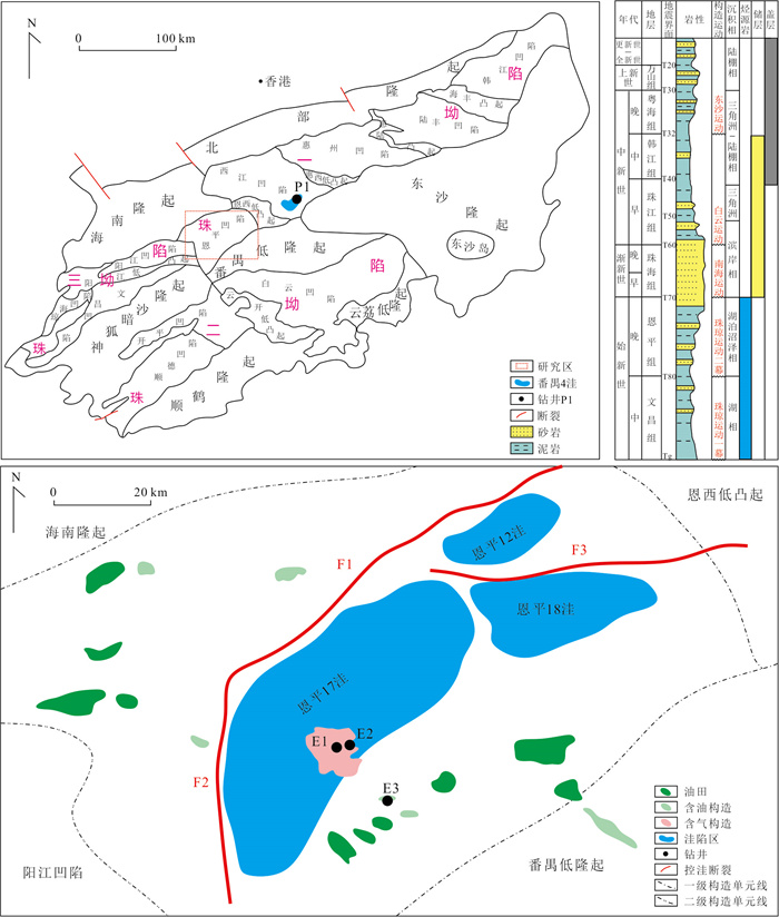
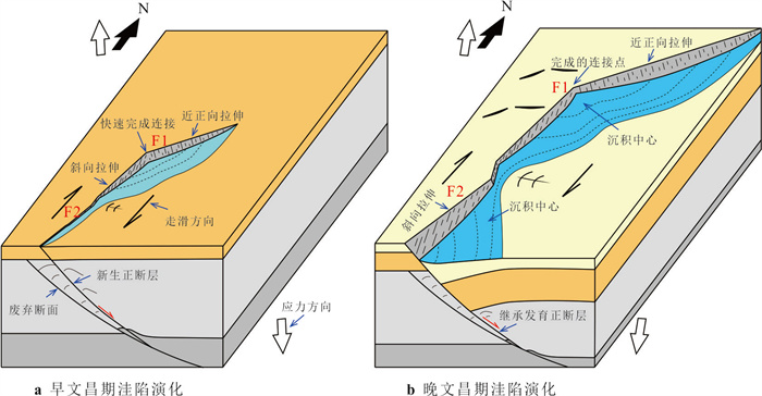
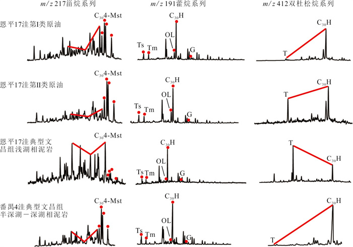
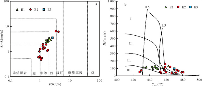
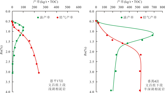
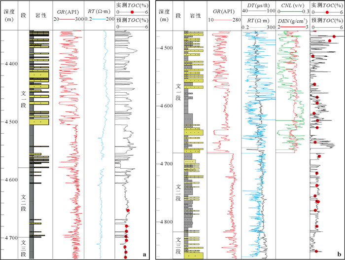
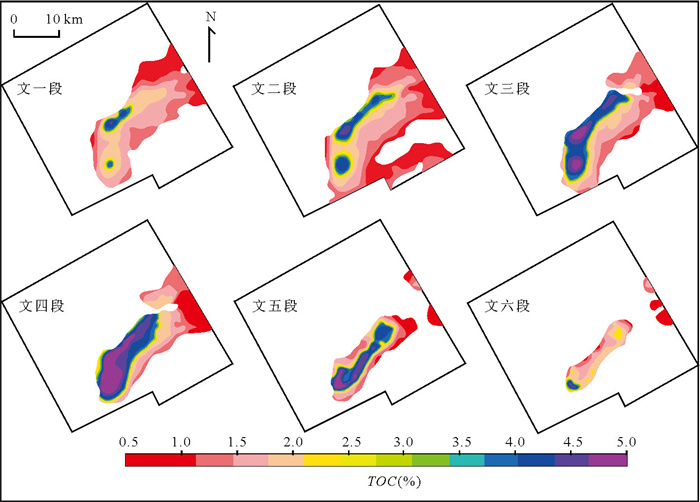
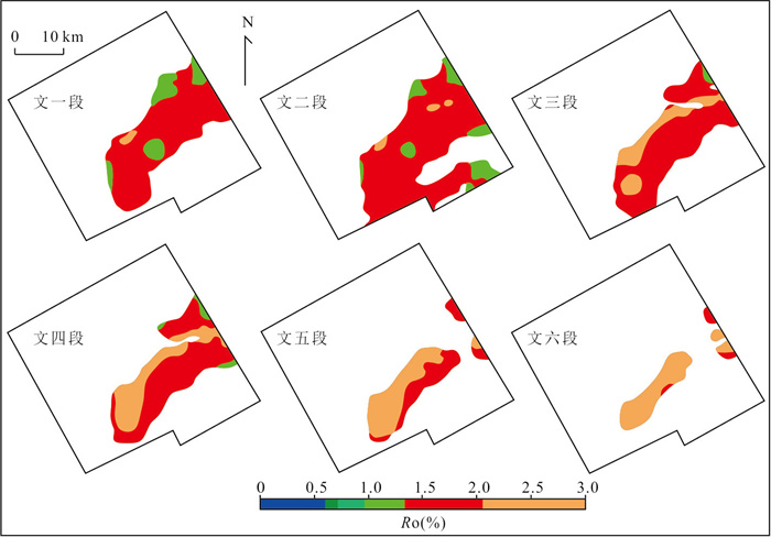
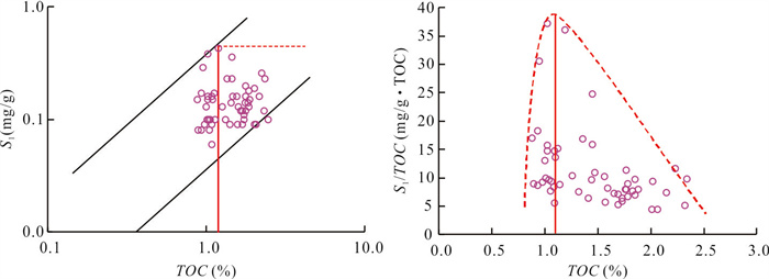
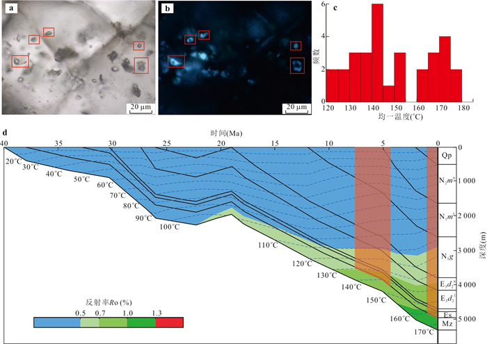
In order to fully understand the characteristics of main source rocks and the distribution of effective source kitchen in Enping 17 sub-sag, it systematically analyzes the geological background of the depression, the development environment of hydrocarbon source rocks and the geochemical characteristics, the hydrocarbon generation characteristics of hydrocarbon source rocks by means of thermal pressure simulation experiments, establishes the TOC probability neural network prediction model of hydrocarbon source rocks, and predicts the distribution of effective source kitchen in combination with the thermal evolution simulation of hydrocarbon source rocks and the identification of the TOC lower limit of effective hydrocarbon source rocks.The results indicate that the Enping 17 sub-sag mainly develops two sets of hydrocarbon source rocks, the semi deep-deep lake and shallow lake facies of the Wenchang Formation. The oil and gas production rates of the semi deep-deep lake facies are relatively high, with the characteristics of concentrated oil generation and late explosive gas generation. Shallow lacustrine mudstone has a relatively high gas production rate and is characterized by wide window continuous gas generation and a high lower limit of gas generation. The effective source kitchen of Wenchang Formation in Enping 17 sub-sag are distributed in the areas where the TOC of source rocks is greater than 1.2%, mainly distributed in the sub-sag center and the northern near sub-sag on the plane, mainly distributed in the 4th member of Wenchang Formation vertically, followed by the 3rd and 5th member of Wenchang Formation. The facies are dominated by semi deep-deep lake facies, while the shallow lake facies source rocks are another set of important source rocks in this area. Under the high thermal evolution, oil and gas are generated simultaneously in the sub-sag, which has the development of large-scale natural gas potential, provides a resource basis for searching for natural gas in oil rich sag of the Pearl River Mouth basin.
In order to fully understand the characteristics of main source rocks and the distribution of effective source kitchen in Enping 17 sub-sag, it systematically analyzes the geological background of the depression, the development environment of hydrocarbon source rocks and the geochemical characteristics, the hydrocarbon generation characteristics of hydrocarbon source rocks by means of thermal pressure simulation experiments, establishes the TOC probability neural network prediction model of hydrocarbon source rocks, and predicts the distribution of effective source kitchen in combination with the thermal evolution simulation of hydrocarbon source rocks and the identification of the TOC lower limit of effective hydrocarbon source rocks.The results indicate that the Enping 17 sub-sag mainly develops two sets of hydrocarbon source rocks, the semi deep-deep lake and shallow lake facies of the Wenchang Formation. The oil and gas production rates of the semi deep-deep lake facies are relatively high, with the characteristics of concentrated oil generation and late explosive gas generation. Shallow lacustrine mudstone has a relatively high gas production rate and is characterized by wide window continuous gas generation and a high lower limit of gas generation. The effective source kitchen of Wenchang Formation in Enping 17 sub-sag are distributed in the areas where the TOC of source rocks is greater than 1.2%, mainly distributed in the sub-sag center and the northern near sub-sag on the plane, mainly distributed in the 4th member of Wenchang Formation vertically, followed by the 3rd and 5th member of Wenchang Formation. The facies are dominated by semi deep-deep lake facies, while the shallow lake facies source rocks are another set of important source rocks in this area. Under the high thermal evolution, oil and gas are generated simultaneously in the sub-sag, which has the development of large-scale natural gas potential, provides a resource basis for searching for natural gas in oil rich sag of the Pearl River Mouth basin.
2025, 50(12): 4617-4634.
doi: 10.3799/dqkx.2025.218
Abstract:
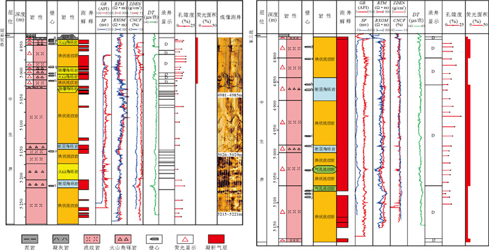
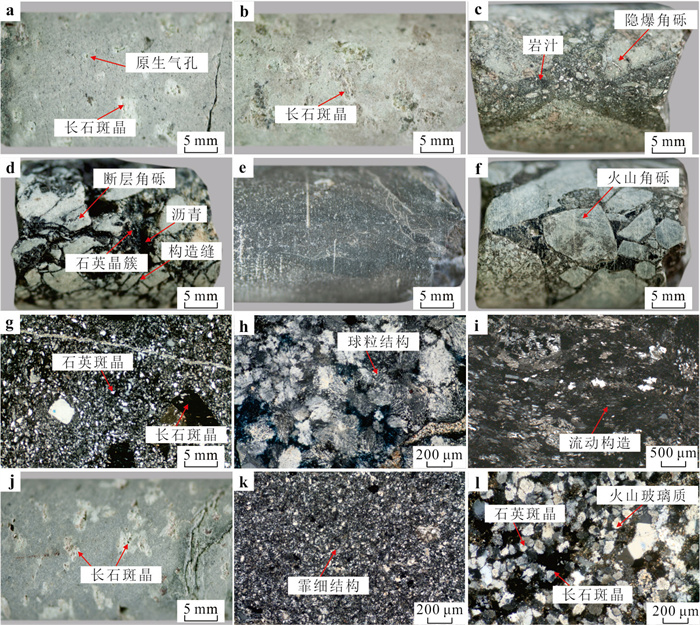
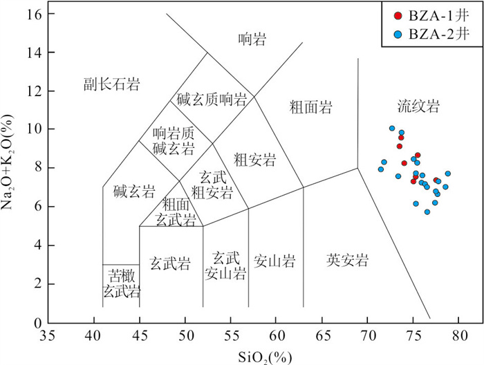
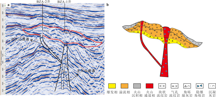
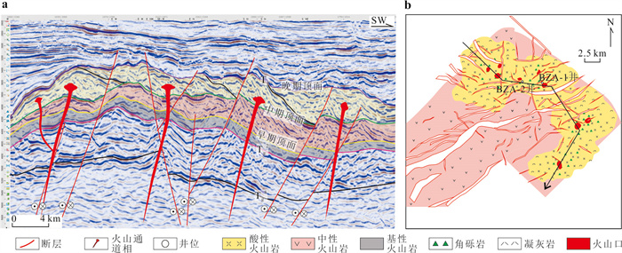
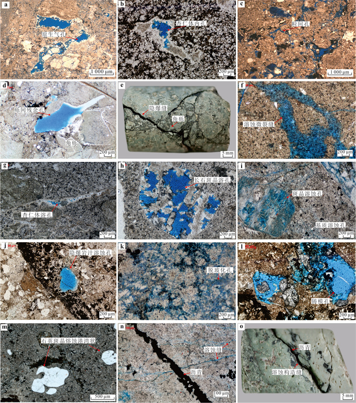
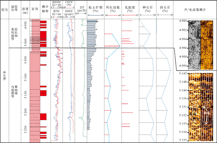
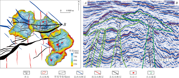
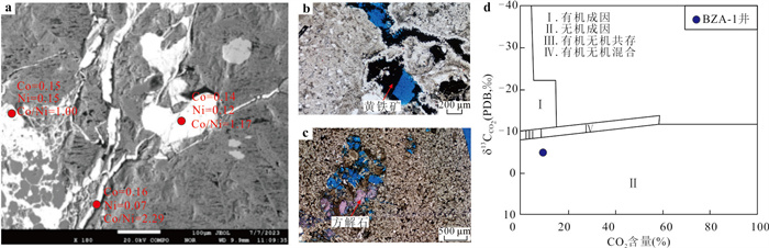
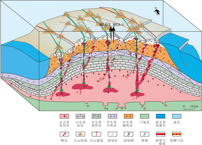
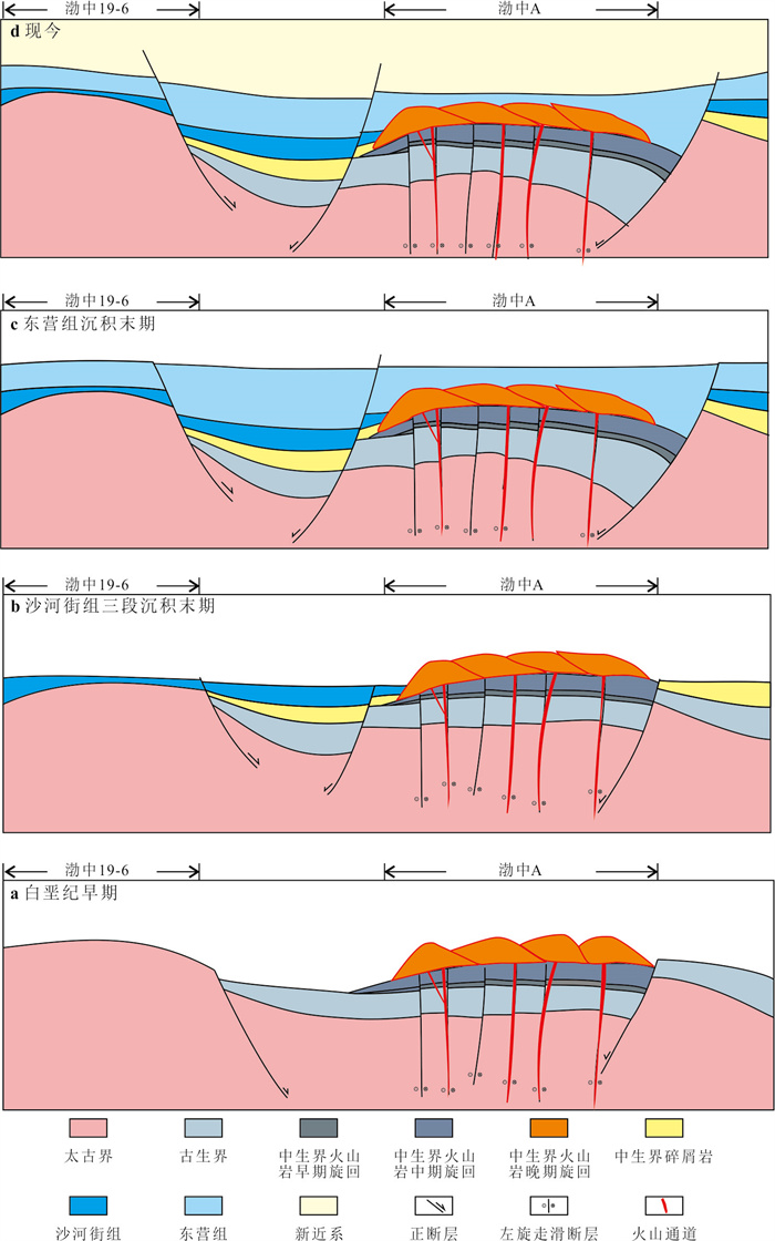
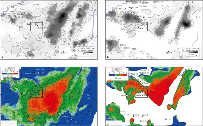
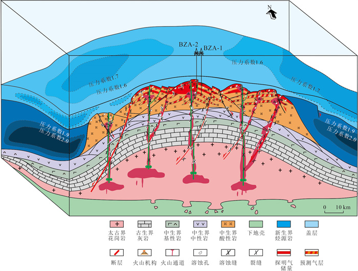
Mesozoic volcanic rocks are widely developed in the Bohai Bay basin. However, the exploration of large-scale volcanic hydrocarbon reservoirs has remained a persistent challenge in deep buried-hill plays in the Bohai area. To investigate the primary controls on substantial hydrocarbon accumulation, this study focuses on the Bohai A Mesozoic volcanic rocks, which have recently achieved significant exploration breakthroughs in the Bohai Sea area, as the research target area. drilling and logging data, sidewall core and thin-section observations, petrochemical analyses combined with 3D seismic, it characterizes the lithology-facies associations, volcanic edifice types, reservoir space characteristics, and key factors governing hydrocarbon accumulation. Research has shown that the BZ-A structure develops three volcanic rock cycles from base to top: basic, intermediate, and acidic. The late stage acidic volcanic rock cycle is composed of multiple large and medium-sized acidic lava volcanic structures stacked together, and is a thick and stable distribution of rhyolite. It mainly develops three types of rock types: effusive facies including vesicular and massive rhyolites, and volcanic conduit facies represented by rhyolitic cryptoexplosive breccia, which have the lithological and lithological basis for developing high-quality volcanic rock reservoirs. Although primary porosity is limited, extensive secondary modification-driven by intense tectonic activity and multi-phase fluid dissolution—has developed abundant structural fractures and dissolution pores/fissures.. The reservoir is vertically divided into a surface weathering dissolution zone and an inner crack dissolution zone with a double-layer reservoir structure, and the overall structure is a large-scale high-quality fracture solution with high porosity and permeability. The favorable factors for oil and gas accumulation in BZ-A include high porosity and permeability acidic volcanic rock fracture solution bodies, ancient uplifted anticline traps, proximity to the Bozhong hydrocarbon rich depression, overlying thick layer overpressure mudstone, and late stage weak tectonic activity. Based on these findings, a comprehensive hydrocarbon accumulation model for ultra deep, large-scale Mesozoic volcanic reservoirs is established, which offers valuable insights for volcanic hydrocarbon exploration in the Bohai Bay basin and analogous settings worldwide.
Mesozoic volcanic rocks are widely developed in the Bohai Bay basin. However, the exploration of large-scale volcanic hydrocarbon reservoirs has remained a persistent challenge in deep buried-hill plays in the Bohai area. To investigate the primary controls on substantial hydrocarbon accumulation, this study focuses on the Bohai A Mesozoic volcanic rocks, which have recently achieved significant exploration breakthroughs in the Bohai Sea area, as the research target area. drilling and logging data, sidewall core and thin-section observations, petrochemical analyses combined with 3D seismic, it characterizes the lithology-facies associations, volcanic edifice types, reservoir space characteristics, and key factors governing hydrocarbon accumulation. Research has shown that the BZ-A structure develops three volcanic rock cycles from base to top: basic, intermediate, and acidic. The late stage acidic volcanic rock cycle is composed of multiple large and medium-sized acidic lava volcanic structures stacked together, and is a thick and stable distribution of rhyolite. It mainly develops three types of rock types: effusive facies including vesicular and massive rhyolites, and volcanic conduit facies represented by rhyolitic cryptoexplosive breccia, which have the lithological and lithological basis for developing high-quality volcanic rock reservoirs. Although primary porosity is limited, extensive secondary modification-driven by intense tectonic activity and multi-phase fluid dissolution—has developed abundant structural fractures and dissolution pores/fissures.. The reservoir is vertically divided into a surface weathering dissolution zone and an inner crack dissolution zone with a double-layer reservoir structure, and the overall structure is a large-scale high-quality fracture solution with high porosity and permeability. The favorable factors for oil and gas accumulation in BZ-A include high porosity and permeability acidic volcanic rock fracture solution bodies, ancient uplifted anticline traps, proximity to the Bozhong hydrocarbon rich depression, overlying thick layer overpressure mudstone, and late stage weak tectonic activity. Based on these findings, a comprehensive hydrocarbon accumulation model for ultra deep, large-scale Mesozoic volcanic reservoirs is established, which offers valuable insights for volcanic hydrocarbon exploration in the Bohai Bay basin and analogous settings worldwide.
2025, 50(12): 4635-4651.
doi: 10.3799/dqkx.2025.150
Abstract:
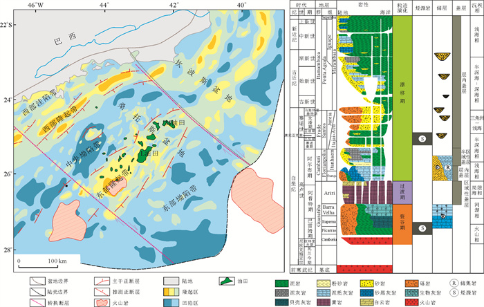
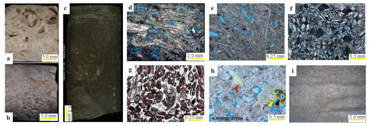
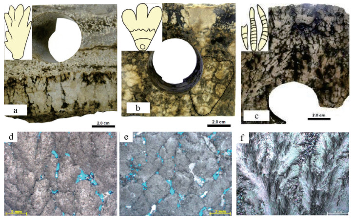
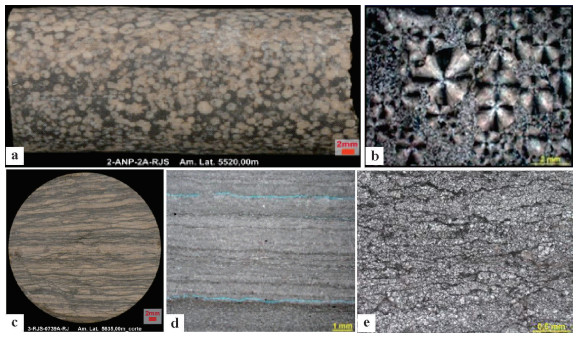
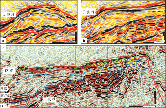
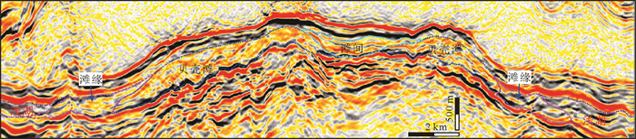
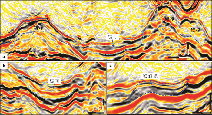
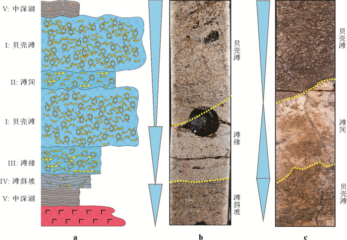
The rift stage (Barremian-Aptian of the Early Cretaceous) of the Santos basin in Brazil is characterized by the development of world-class large-scale lacustrine carbonates deposition. At present, numerous oil and gas discoveries have been made in this field, making it a hot spot for global oil and gas exploration. The development degree of carbonate sediments is the key to the enrichment and accumulation of oil and gas in the basin. Drilling results reveal the development of "two phases and two types" of lacustrine carbonate sediments during the rift stage of the basin: shell limestone of Itapema (ITP) group in early fault-sag depression transition period (Late Barremian-Aptian) and microbial reef limestone of Barra Velha (BV) group in late sag depression period (Mid-Late Aptian). Although both of these "two phases and two types" lacustrine carbonate sediments are biogenic limestone, their genesis mechanisms and lithological combinations differ significantly. In order to clarify the sedimentary differences and main controlling factors of the "two phases and two types" lacustrine carbonate rocks, based on thin section, core, logging, seismic and other data, this paper conducts a systematic petrological and sedimentological study of two types of lacustrine carbonate sediments in the basin, combining micro and macro perspectives. Comprehensive research shows the development of large-scale lacustrine carbonate sediment in the Lower Cretaceous of the Santos basin in Brazil is mainly controlled by paleogeomorphology, paleolake water salinity and paleowater energy changes. Paleogeomorphology controls the distribution and development of sedimentary microfacies of lacustrine carbonate reservoirs, paleowater salinity controls the vertical evolution of lacustrine carbonate sediments types, and paleowater energy and water depth control the microfacies variation of lacustrine carbonate sediments. Finally, it was confirmed that the high-energy freshwater environment in the face of waves is a favorable background for the development of shell limestone reservoir in Itapema Formation, and the shallow medium-high energy semi saline-saline water environment in the face of waves is a favorable background for the development of stromatolitic limestone reservoir in Barra Velha Formation. This points out the directions for finding favorable reservoir development zones and has practical guiding significance for the oil and gas exploration in lacustrine carbonate rocks of Brazil.
The rift stage (Barremian-Aptian of the Early Cretaceous) of the Santos basin in Brazil is characterized by the development of world-class large-scale lacustrine carbonates deposition. At present, numerous oil and gas discoveries have been made in this field, making it a hot spot for global oil and gas exploration. The development degree of carbonate sediments is the key to the enrichment and accumulation of oil and gas in the basin. Drilling results reveal the development of "two phases and two types" of lacustrine carbonate sediments during the rift stage of the basin: shell limestone of Itapema (ITP) group in early fault-sag depression transition period (Late Barremian-Aptian) and microbial reef limestone of Barra Velha (BV) group in late sag depression period (Mid-Late Aptian). Although both of these "two phases and two types" lacustrine carbonate sediments are biogenic limestone, their genesis mechanisms and lithological combinations differ significantly. In order to clarify the sedimentary differences and main controlling factors of the "two phases and two types" lacustrine carbonate rocks, based on thin section, core, logging, seismic and other data, this paper conducts a systematic petrological and sedimentological study of two types of lacustrine carbonate sediments in the basin, combining micro and macro perspectives. Comprehensive research shows the development of large-scale lacustrine carbonate sediment in the Lower Cretaceous of the Santos basin in Brazil is mainly controlled by paleogeomorphology, paleolake water salinity and paleowater energy changes. Paleogeomorphology controls the distribution and development of sedimentary microfacies of lacustrine carbonate reservoirs, paleowater salinity controls the vertical evolution of lacustrine carbonate sediments types, and paleowater energy and water depth control the microfacies variation of lacustrine carbonate sediments. Finally, it was confirmed that the high-energy freshwater environment in the face of waves is a favorable background for the development of shell limestone reservoir in Itapema Formation, and the shallow medium-high energy semi saline-saline water environment in the face of waves is a favorable background for the development of stromatolitic limestone reservoir in Barra Velha Formation. This points out the directions for finding favorable reservoir development zones and has practical guiding significance for the oil and gas exploration in lacustrine carbonate rocks of Brazil.
2025, 50(12): 4652-4670.
doi: 10.3799/dqkx.2025.130
Abstract:
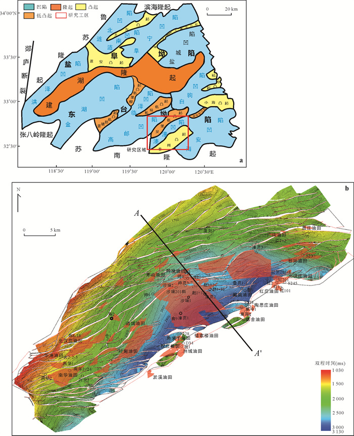
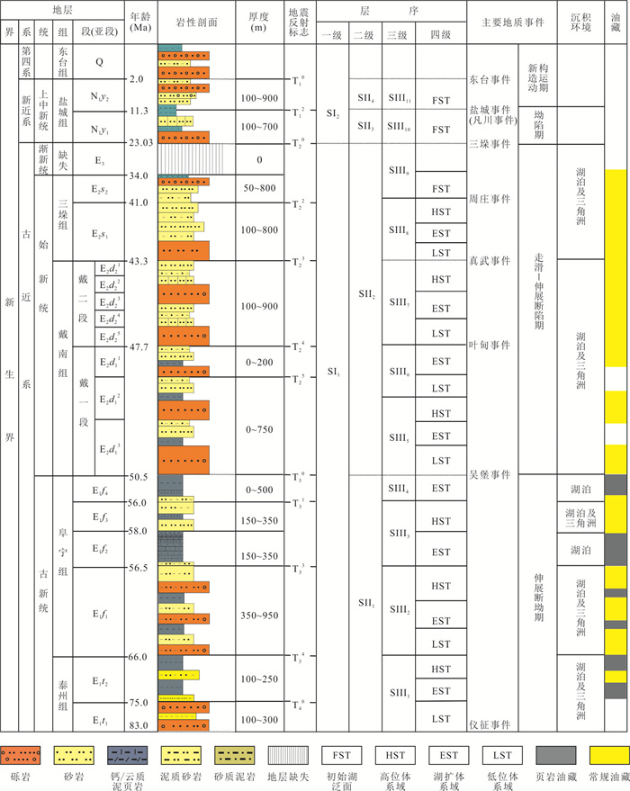
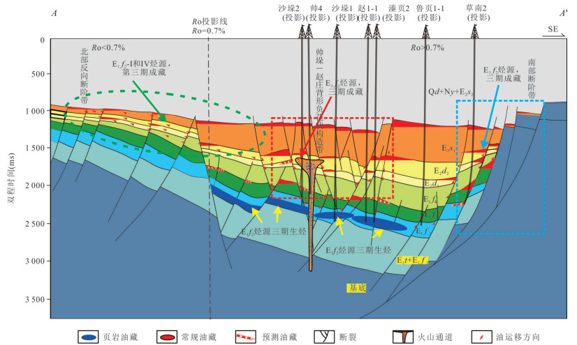
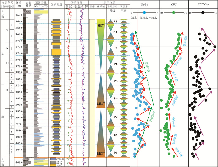
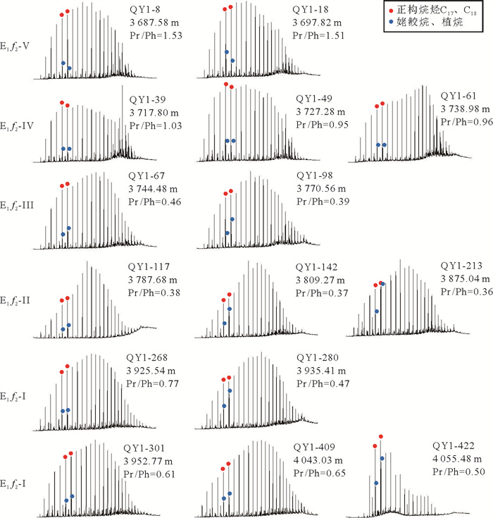
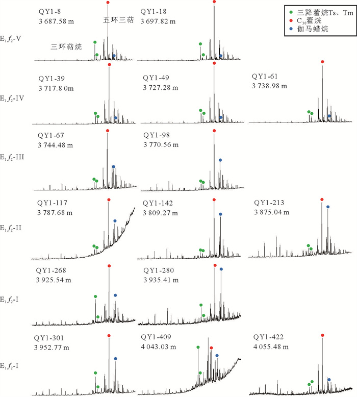
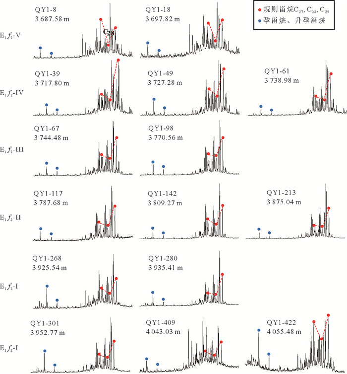
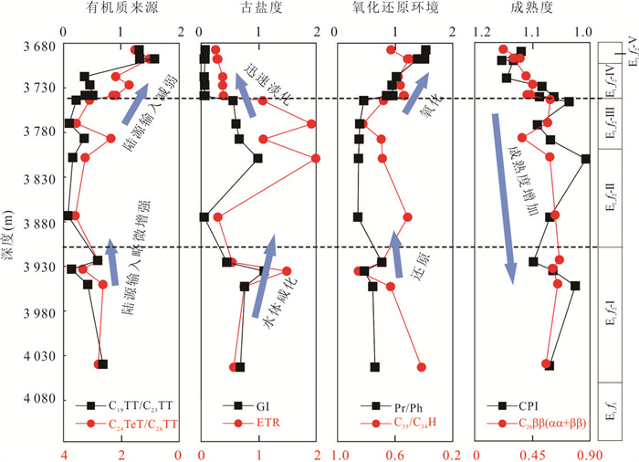
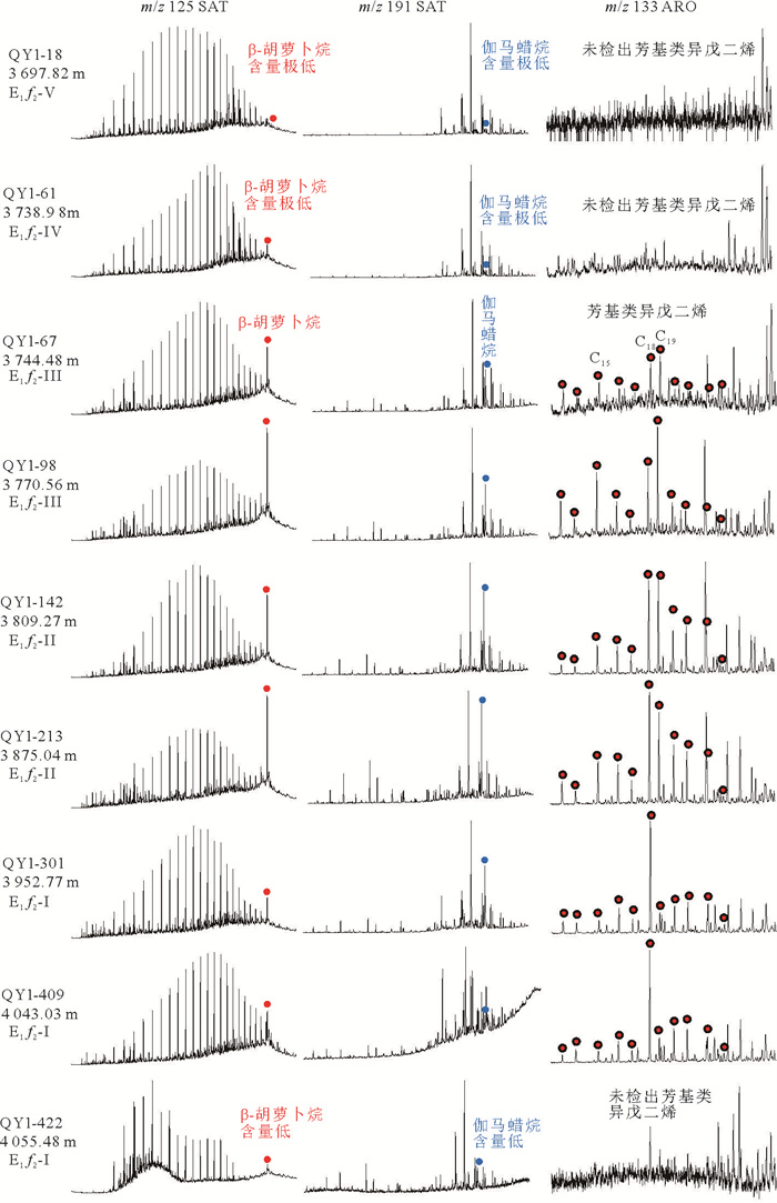
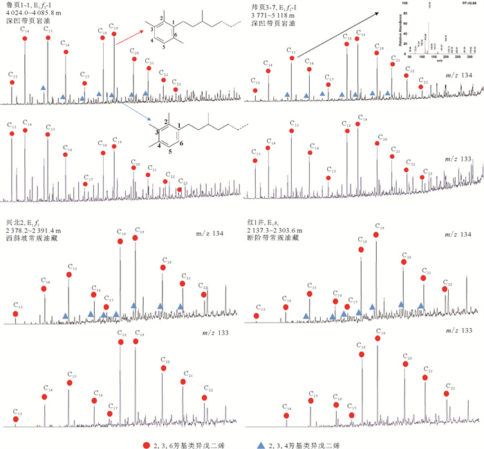
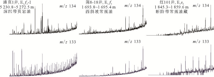
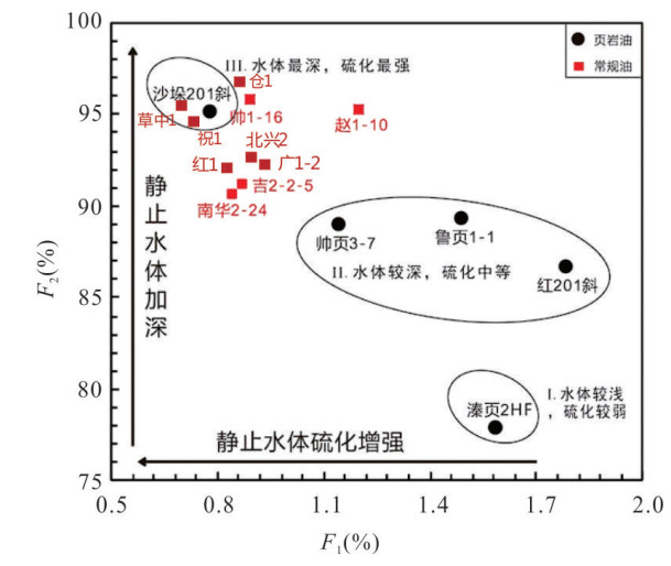
With the continual progressing of shale oil exploration and development in lacustrine facies, the investigation in Qintong sag of Subei basin steps into the stage of whole petroleum system evaluation. The previous oil correlation researches focused on the influence of salinity of lake water during source rock development onto biomarkers, which is hard to satisfy the requirement of oil correlation with the source rocks of "contemporaneous heterotopic facies" for whole petroleum system. This study is on the basis of analysis of controlling of high-resolution sequence stratigraphy driven by paleoclimate on source rock development and distribution, totally 11 shale oil and conventional crude oil samples in Qintong sag have been employed to measure the aryl isoprenoid biomarkers which can reflect sulfuration habitat and be used to correlate the whole petroleum system with source rocks. Meanwhile, the 2, 3, 6- aryl isoprenoids (2, 3, 6-AIPs) and 2, 3, 4- aryl isoprenoids (2, 3, 4-AIPs) have been applied to build two parameters: C3=Σ(2, 3, 6-AIPs)/Σ(2, 3, 4-AIPs) and C4=Σ(2, 3, 6-AIPs)/ Σ(2, 3, 4-AIPs)+ Σ(2, 3, 6-AIPs), which are utilized to calculate the relative sulfuration intensity and relative paleo-depth of lake water for the source rocks of shale oils and conventional crude oils, respectively. And then, several research results have been obtained as following. (1) The second member of Funing Formation in Qintong sag underwent the low frequency cycle of earlier lake expansion system tract (EEST)→later lake expansion system tract (LEST) →high level system tract (HST), which can be divided into high frequency cycle of 9-fourth level quasi-sequence group (P1-P9), and 32.5-fifth level subsequences, which indicates the total tendency from the (semi-) haline water during the earlier cold and dry paleoclimate evolving into the fresh water during the later warm and humid paleoclimate. (2) The relative higher values of residual total organic carbon (TOC) in the second member of Funing Formation are always corresponding to the maximum lake flooding surface of system tract cycles with warm and humid paleo-climate and fresh water; and the relative lower values of residual TOC being always corresponding to the initial lake flooding surface with cold and dry paleo-climate and (semi-) haline water. This leads to a conclusion that bathyal-deep lake environments with warm, humid paleoclimate and fresh water are more beneficial to organic enrichment. (3) Four types of source rocks in the second member of Funing Formation can be recognized: the first is relatively shallower water column and weaker sulfuration facies; the second being relatively deeper water column and moderate sulfuration facies; the third being deeper water column and intensive sulfuration facies; and the fourth being deeper and fresh water column facies. This research is not only providing a new tool for "contemporaneous heterotopic facies" source rock evolution, but also giving the evidence to establish the distribution sequence of whole petroleum system.
With the continual progressing of shale oil exploration and development in lacustrine facies, the investigation in Qintong sag of Subei basin steps into the stage of whole petroleum system evaluation. The previous oil correlation researches focused on the influence of salinity of lake water during source rock development onto biomarkers, which is hard to satisfy the requirement of oil correlation with the source rocks of "contemporaneous heterotopic facies" for whole petroleum system. This study is on the basis of analysis of controlling of high-resolution sequence stratigraphy driven by paleoclimate on source rock development and distribution, totally 11 shale oil and conventional crude oil samples in Qintong sag have been employed to measure the aryl isoprenoid biomarkers which can reflect sulfuration habitat and be used to correlate the whole petroleum system with source rocks. Meanwhile, the 2, 3, 6- aryl isoprenoids (2, 3, 6-AIPs) and 2, 3, 4- aryl isoprenoids (2, 3, 4-AIPs) have been applied to build two parameters: C3=Σ(2, 3, 6-AIPs)/Σ(2, 3, 4-AIPs) and C4=Σ(2, 3, 6-AIPs)/ Σ(2, 3, 4-AIPs)+ Σ(2, 3, 6-AIPs), which are utilized to calculate the relative sulfuration intensity and relative paleo-depth of lake water for the source rocks of shale oils and conventional crude oils, respectively. And then, several research results have been obtained as following. (1) The second member of Funing Formation in Qintong sag underwent the low frequency cycle of earlier lake expansion system tract (EEST)→later lake expansion system tract (LEST) →high level system tract (HST), which can be divided into high frequency cycle of 9-fourth level quasi-sequence group (P1-P9), and 32.5-fifth level subsequences, which indicates the total tendency from the (semi-) haline water during the earlier cold and dry paleoclimate evolving into the fresh water during the later warm and humid paleoclimate. (2) The relative higher values of residual total organic carbon (TOC) in the second member of Funing Formation are always corresponding to the maximum lake flooding surface of system tract cycles with warm and humid paleo-climate and fresh water; and the relative lower values of residual TOC being always corresponding to the initial lake flooding surface with cold and dry paleo-climate and (semi-) haline water. This leads to a conclusion that bathyal-deep lake environments with warm, humid paleoclimate and fresh water are more beneficial to organic enrichment. (3) Four types of source rocks in the second member of Funing Formation can be recognized: the first is relatively shallower water column and weaker sulfuration facies; the second being relatively deeper water column and moderate sulfuration facies; the third being deeper water column and intensive sulfuration facies; and the fourth being deeper and fresh water column facies. This research is not only providing a new tool for "contemporaneous heterotopic facies" source rock evolution, but also giving the evidence to establish the distribution sequence of whole petroleum system.
2025, 50(12): 4671-4684.
doi: 10.3799/dqkx.2025.211
Abstract:
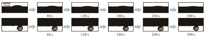
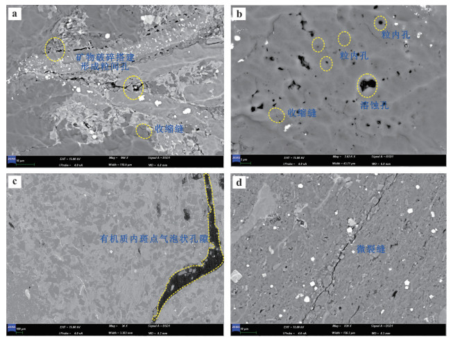
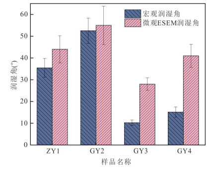
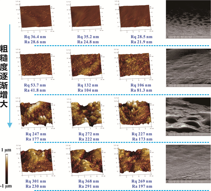
As an important unconventional energy resource, the efficient development of shale oil is of great significance for ensuring energy security. Shale reservoirs exhibit characteristics of low porosity and permeability, complex pore structures, and diverse mineral compositions, resulting in extremely complex wettability characteristics. Wettability, as a key parameter controlling oil phase occurrence and flow, directly affects shale oil development efficiency. Traditional wettability studies mainly rely on macroscopic contact angle measurements, which struggle to accurately reveal wetting behavior in nanoscale pores and its control mechanisms on oil phase mobility. This study aims to establish a multi-scale wettability characterization method for shale reservoirs and reveal the intrinsic relationships among wettability characteristics, pore structure, and oil phase mobility. Based on Gulong shale samples, macro- and microscopic contact angle measurements were employed to characterize multi-scale wettability features, nuclear magnetic resonance technology was used to independently evaluate oil phase mobility in different-scale pores, and systematic correlation analysis was conducted to explore the control mechanisms of wettability on mobility. The study found that although microscopic contact angles are systematically larger than macroscopic values, the measurement trends from both methods are highly consistent, validating the reliability of cross-scale characterization. Different from previous single-scale understanding, this study reveals that pore structure and mobility require synergistic evaluation: optimal reservoirs may not be those with the highest proportion of large pores, but rather those with balanced pore structure (60%-80% large pore proportion) and high mobility in all pore sizes; additionally, mineral components exhibit differentiated control effects on multi-scale pore system recovery rates, with quartz content showing significant positive correlation with both large and small pore recovery rates, while different clay minerals demonstrate scale-dependent complex influences. Through correlation analysis, qualitative relationships between wettability and mobility, as well as quantitative evaluation models between mineral components and mobility, were established. This research provides new evaluation methods for shale oil reservoir sweet spot identification, emphasizing the need to comprehensively consider the synergistic effects of pore structure, wettability, and mobility.
As an important unconventional energy resource, the efficient development of shale oil is of great significance for ensuring energy security. Shale reservoirs exhibit characteristics of low porosity and permeability, complex pore structures, and diverse mineral compositions, resulting in extremely complex wettability characteristics. Wettability, as a key parameter controlling oil phase occurrence and flow, directly affects shale oil development efficiency. Traditional wettability studies mainly rely on macroscopic contact angle measurements, which struggle to accurately reveal wetting behavior in nanoscale pores and its control mechanisms on oil phase mobility. This study aims to establish a multi-scale wettability characterization method for shale reservoirs and reveal the intrinsic relationships among wettability characteristics, pore structure, and oil phase mobility. Based on Gulong shale samples, macro- and microscopic contact angle measurements were employed to characterize multi-scale wettability features, nuclear magnetic resonance technology was used to independently evaluate oil phase mobility in different-scale pores, and systematic correlation analysis was conducted to explore the control mechanisms of wettability on mobility. The study found that although microscopic contact angles are systematically larger than macroscopic values, the measurement trends from both methods are highly consistent, validating the reliability of cross-scale characterization. Different from previous single-scale understanding, this study reveals that pore structure and mobility require synergistic evaluation: optimal reservoirs may not be those with the highest proportion of large pores, but rather those with balanced pore structure (60%-80% large pore proportion) and high mobility in all pore sizes; additionally, mineral components exhibit differentiated control effects on multi-scale pore system recovery rates, with quartz content showing significant positive correlation with both large and small pore recovery rates, while different clay minerals demonstrate scale-dependent complex influences. Through correlation analysis, qualitative relationships between wettability and mobility, as well as quantitative evaluation models between mineral components and mobility, were established. This research provides new evaluation methods for shale oil reservoir sweet spot identification, emphasizing the need to comprehensively consider the synergistic effects of pore structure, wettability, and mobility.
2025, 50(12): 4685-4696.
doi: 10.3799/dqkx.2025.168
Abstract:
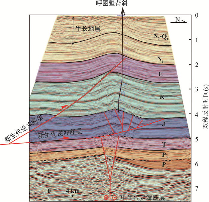
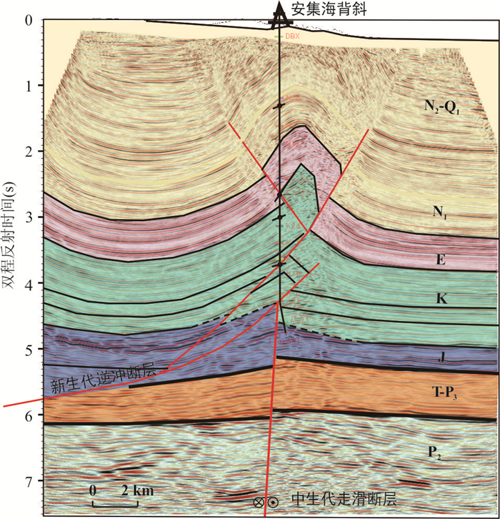
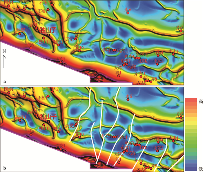
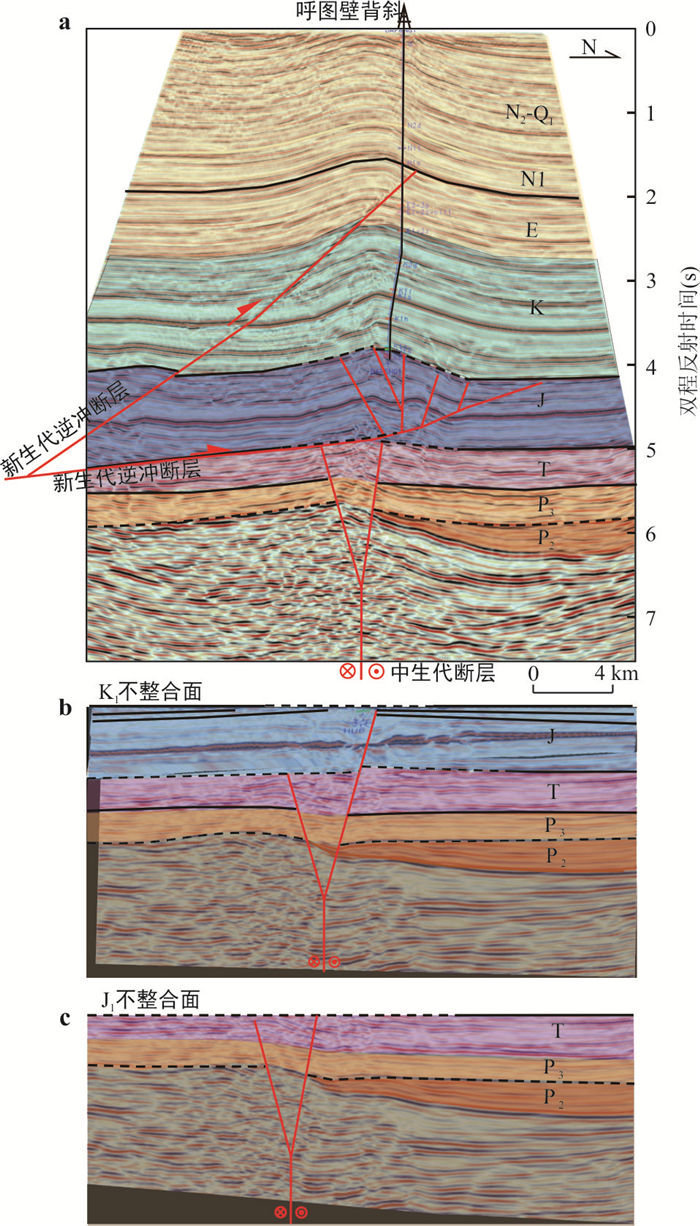
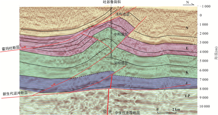
The fold-thrust belt in the northern piedmont of the Tianshan Mountains underwent polyphase tectonic deformation, acquiring its present configuration during the Late Cenozoic contractional regime. Under multiphase superposition, the influence of basement architecture on subsequent compressive deformation remains constrained. This study investigates the Mesozoic structural characteristics and deformation mechanisms in the northern piedmont of the Tianshan Mountains based on seismic, drilling, and field observation data, aiming to reveal the influence and controlling factors of Mesozoic structures on Cenozoic deformation and hydrocarbon migration-accumulation. Strike-slip faults were developed in the Mesozoic in the northern piedmont of Tianshan Mountain, and were covered by the Cretaceous-Cenozoic strata. Under the Late Cenozoic compression environment, the Mesozoic strike-slip fault was reactivated, and the Cenozoic thrust fault and fold superimposed on the Mesozoic fault. The reactivation of Mesozoic structures played an important role in shaping the present structure of the northern piedmont of Tianshan Mountain. According to the deformation sequence, the sedimentary strata in the southern Junggar basin. are divided into three structural layers—shallow, intermediate, and deep. These tiers correspond to upper, middle, and lower hydrocarbon accumulation assemblages, respectively, with the intermediate and deep structural tiers demonstrating particularly significant exploration potential. In this paper it reveals the relationship between deep faults and late compressive structures in the northern piedmont of Tianshan Mountain, explains the influence of multi-stage tectonic evolution on oil and gas exploration, and has reference significance for the study of similar structures in the basins of western China.
The fold-thrust belt in the northern piedmont of the Tianshan Mountains underwent polyphase tectonic deformation, acquiring its present configuration during the Late Cenozoic contractional regime. Under multiphase superposition, the influence of basement architecture on subsequent compressive deformation remains constrained. This study investigates the Mesozoic structural characteristics and deformation mechanisms in the northern piedmont of the Tianshan Mountains based on seismic, drilling, and field observation data, aiming to reveal the influence and controlling factors of Mesozoic structures on Cenozoic deformation and hydrocarbon migration-accumulation. Strike-slip faults were developed in the Mesozoic in the northern piedmont of Tianshan Mountain, and were covered by the Cretaceous-Cenozoic strata. Under the Late Cenozoic compression environment, the Mesozoic strike-slip fault was reactivated, and the Cenozoic thrust fault and fold superimposed on the Mesozoic fault. The reactivation of Mesozoic structures played an important role in shaping the present structure of the northern piedmont of Tianshan Mountain. According to the deformation sequence, the sedimentary strata in the southern Junggar basin. are divided into three structural layers—shallow, intermediate, and deep. These tiers correspond to upper, middle, and lower hydrocarbon accumulation assemblages, respectively, with the intermediate and deep structural tiers demonstrating particularly significant exploration potential. In this paper it reveals the relationship between deep faults and late compressive structures in the northern piedmont of Tianshan Mountain, explains the influence of multi-stage tectonic evolution on oil and gas exploration, and has reference significance for the study of similar structures in the basins of western China.
2025, 50(12): 4697-4714.
doi: 10.3799/dqkx.2025.133
Abstract:
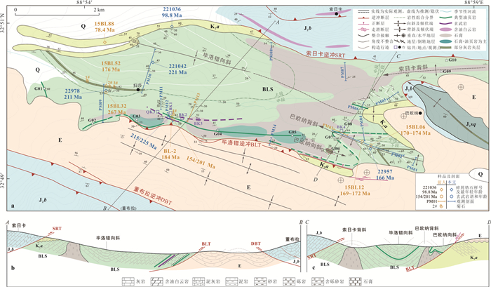
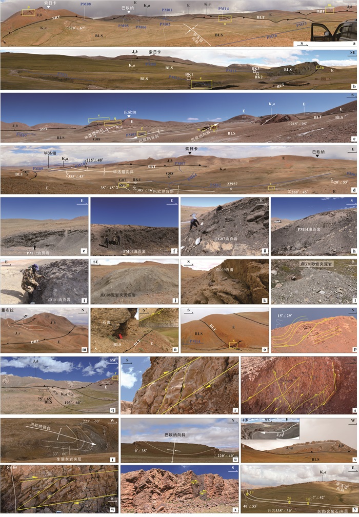
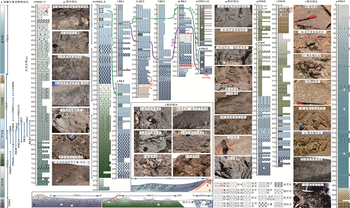
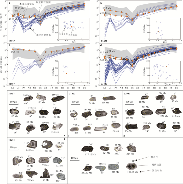
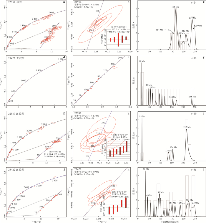
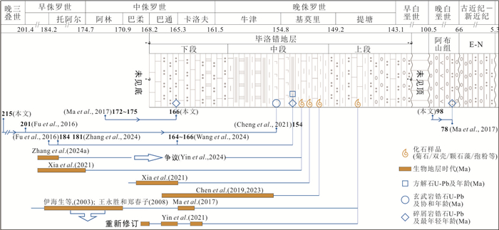
Influenced by multi-phase thrusting,extensional tectonic movements,and the plastic deformation of mudstone,shale,and gypsum,the deformation of the Biluoco oil shale stratum (BLS) in the Qiangtang basin is extremely complex. Additionally,controversies surrounding paleontological fossil evidence and isotopic geochronology have severely constrained the understanding of the lithological assemblages and their temporal attribution. In response to the intricate structural deformation of BLS,this study conducted detailed structural observations and profile measurements. Based on the thrust-fold system,the stratum was traced and correlated,dividing into three segments with seven types of lithological assemblages from bottom to top. Zircon U-Pb isotopic testing,along with zircon structure and genetic analysis,was performed on the sandstone of the lower segment and the basalt of the middle segment,yielding maximum depositional ages of 166 Ma and 154 Ma,respectively. Integrating regional context,it is concluded that the age of BLS ranges at least from the Middle Jurassic Bathonian to the Late Jurassic Tithonian,with the top possibly extending to the Early Cretaceous Berriasian. The determination of the age for BLS provides new insights for hydrocarbon exploration in the Qiangtang basin,as well as for studies on sedimentary tectonic evolution and oceanic anoxic events.
Influenced by multi-phase thrusting,extensional tectonic movements,and the plastic deformation of mudstone,shale,and gypsum,the deformation of the Biluoco oil shale stratum (BLS) in the Qiangtang basin is extremely complex. Additionally,controversies surrounding paleontological fossil evidence and isotopic geochronology have severely constrained the understanding of the lithological assemblages and their temporal attribution. In response to the intricate structural deformation of BLS,this study conducted detailed structural observations and profile measurements. Based on the thrust-fold system,the stratum was traced and correlated,dividing into three segments with seven types of lithological assemblages from bottom to top. Zircon U-Pb isotopic testing,along with zircon structure and genetic analysis,was performed on the sandstone of the lower segment and the basalt of the middle segment,yielding maximum depositional ages of 166 Ma and 154 Ma,respectively. Integrating regional context,it is concluded that the age of BLS ranges at least from the Middle Jurassic Bathonian to the Late Jurassic Tithonian,with the top possibly extending to the Early Cretaceous Berriasian. The determination of the age for BLS provides new insights for hydrocarbon exploration in the Qiangtang basin,as well as for studies on sedimentary tectonic evolution and oceanic anoxic events.
2025, 50(12): 4715-4735.
doi: 10.3799/dqkx.2025.189
Abstract:
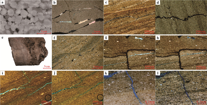
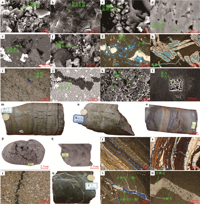
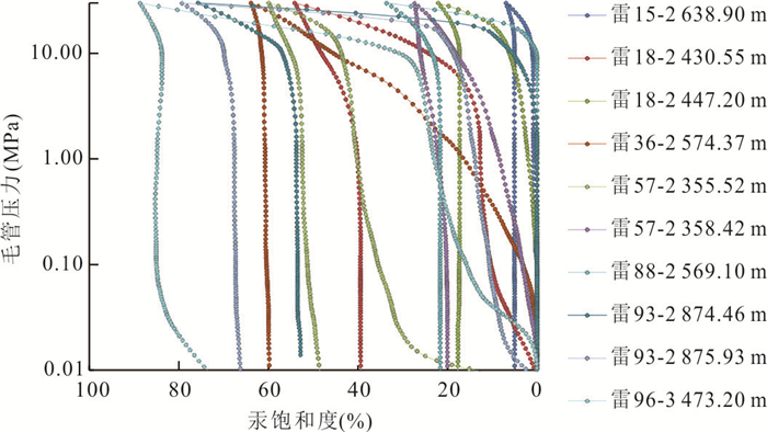
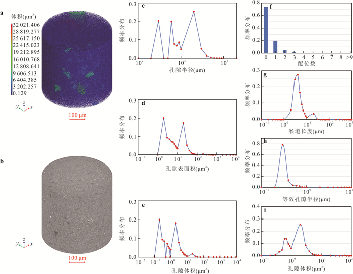
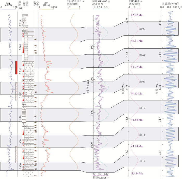
Multiple sets of lacustrine carbonate rocks are developed in the fourth member of the Shahejie Formation (Es4) in the Leijia area of the western sag of the Liaohe Depression. With favorable geological conditions and promising resource potential, this interval currently serves as the primary target for tight oil exploration in the region. To clarify the characteristics of high-quality reservoirs and define exploration targets, this study integrates cyclostratigraphy, drilling, logging, seismic inversion, and analytical testing data to identify astronomical cycles and analyze reservoir properties, aiming to predict the distribution of high-quality "sweet spot" reservoirs. The main findings are as follows.(1) The Es4 member contains approximately six long eccentricity cycles and nineteen short eccentricity cycles, and the relationship between long eccentricity cycles and oil-bearing intervals in the area is elucidated. (2) High-quality reservoirs in the Leijia area are dominated by dolomite, characterized by fine dolomite crystals (mostly 1-3 μm), well-developed intercrystalline pores and structural fractures, micropores mainly distributed in the 0.3-0.4 μm range, effective throat lengths ranging from 1 to 20 μm, and pore volumes primarily between 0.5-4.0 μm3. Light oil components are mainly hosted within fractures and intercrystalline pores. These tight and brittle dolomites are primarily developed within the Du-3 oil layer. (3) A single-well evaluation was conducted using a multi-parameter fusion method to establish reservoir evaluation criteria. Combined with pre-stack geological inversion data, the study clarified the distribution pattern of high-quality sweet spots within the sequence stratigraphic framework and carried out planar prediction. This research systematically refines the stratigraphy and sedimentary reservoir characteristics of lacustrine carbonates in the Es4 member of the western sag, and effectively identifies sweet spot distribution using pre-stack seismic inversion, providing a robust geological basis for tight oil exploration in the area.
Multiple sets of lacustrine carbonate rocks are developed in the fourth member of the Shahejie Formation (Es4) in the Leijia area of the western sag of the Liaohe Depression. With favorable geological conditions and promising resource potential, this interval currently serves as the primary target for tight oil exploration in the region. To clarify the characteristics of high-quality reservoirs and define exploration targets, this study integrates cyclostratigraphy, drilling, logging, seismic inversion, and analytical testing data to identify astronomical cycles and analyze reservoir properties, aiming to predict the distribution of high-quality "sweet spot" reservoirs. The main findings are as follows.(1) The Es4 member contains approximately six long eccentricity cycles and nineteen short eccentricity cycles, and the relationship between long eccentricity cycles and oil-bearing intervals in the area is elucidated. (2) High-quality reservoirs in the Leijia area are dominated by dolomite, characterized by fine dolomite crystals (mostly 1-3 μm), well-developed intercrystalline pores and structural fractures, micropores mainly distributed in the 0.3-0.4 μm range, effective throat lengths ranging from 1 to 20 μm, and pore volumes primarily between 0.5-4.0 μm3. Light oil components are mainly hosted within fractures and intercrystalline pores. These tight and brittle dolomites are primarily developed within the Du-3 oil layer. (3) A single-well evaluation was conducted using a multi-parameter fusion method to establish reservoir evaluation criteria. Combined with pre-stack geological inversion data, the study clarified the distribution pattern of high-quality sweet spots within the sequence stratigraphic framework and carried out planar prediction. This research systematically refines the stratigraphy and sedimentary reservoir characteristics of lacustrine carbonates in the Es4 member of the western sag, and effectively identifies sweet spot distribution using pre-stack seismic inversion, providing a robust geological basis for tight oil exploration in the area.
2025, 50(12): 4736-4750.
doi: 10.3799/dqkx.2025.182
Abstract:
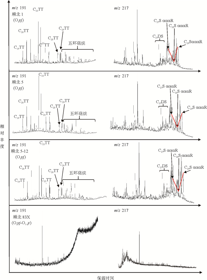
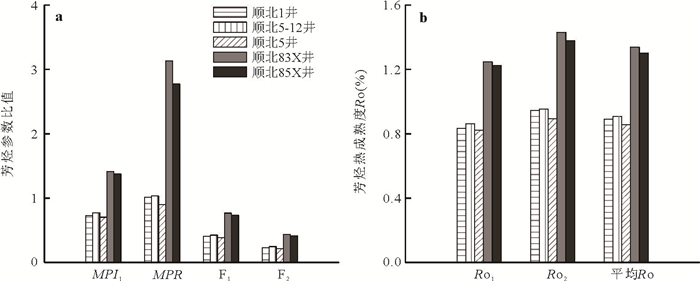
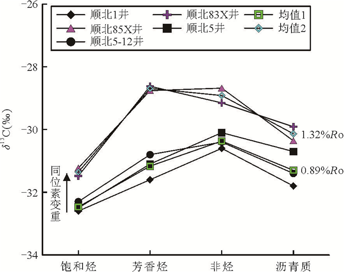
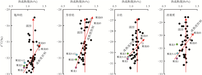
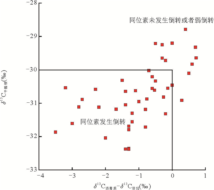
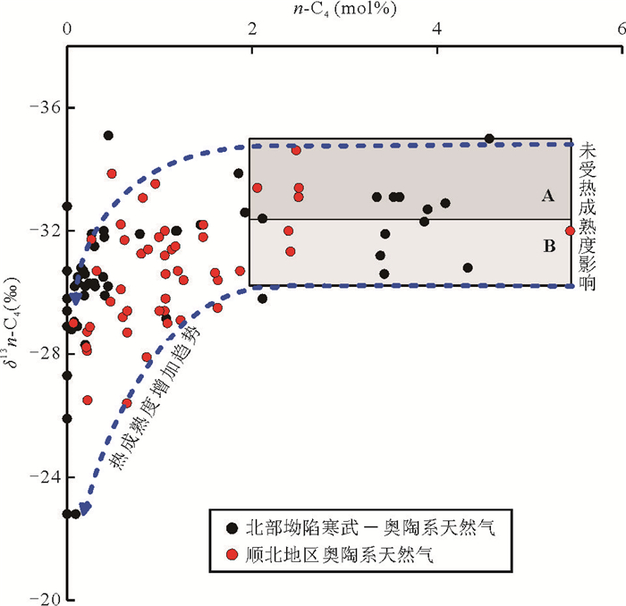
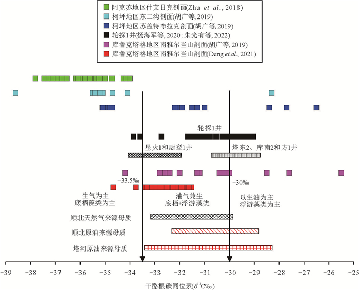
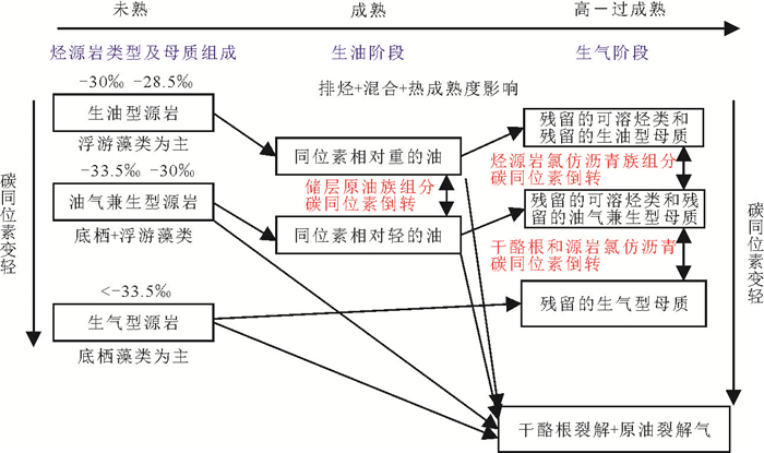
The source rocks of the Lower Cambrian Yurtus Formation have been considered as the main source rocks of marine oil and gas in the Tarim Basin. Currently, the understanding of source rocks of Yurtus Formation is mainly based on the sample analysis in outcrops in the basin margin and drilling core samples in uplift areas of the basin, while the characteristics of source rocks in slope and depression areas are less understood. Understanding the carbon isotope characteristics of kerogen in source rocks of Yurtus formation is of great reference significance for determining the hydrocarbon generation mechanism of source rocks and establishing the correlation between oil and gas sources. In this paper, the organic geochemistry and carbon isotope geochemistry of Ordovician crude oil and natural gas samples from different fault zones in Shunbei area are studied in detail. Based on the quantitative evaluation of the influence of thermal maturity on carbon isotopes of crude oil and natural gas, the initial carbon isotope composition of crude oil and natural gas is reconstructed. The carbon isotopic composition of kerogen from crude oil and natural gas in Shunbei area was recovered by the fractionation between kerogen and oil and gas during hydrocarbon formation. The results show that the carbon isotopes of oil-derived kerogen are mainly in the range of -32.3‰ to -28.8‰, and that of gas-derived kerogen is mainly in the range of -33.1‰ to -29.8‰. The crude oil and natural gas are mainly derived from the mixed source of benthic algae and planktonic algae, and part of crude oils in the Shunbei area are also from the main source of planktonic algae. The light carbon isotope characteristics of kerogen indicate that the oil and gas in Shunbei area mainly come from the source rocks of Yurtus Formation. Based on changes in the assemblage of hydrocarbon forming organisms, the source rocks of Yurtus Formation are divided into oil-generating source rocks with planktonic algae as the main source (δ13C > -30‰), oil-gas generating source rocks with benthic and planktonic algae as the main source (-33.5‰ < δ13C < -30‰) and gas-generating source rocks with benthic algae as the main source (δ13C < -33.5‰). With the increase of thermal maturity of source rocks, the early oil is generated by planktic algae, while the late oil (mainly volatile oil-condensate oil) contributes more, resulting in the early oil isotope is heavier, while the late oil has relatively light carbon isotope characteristics. At the same time, the content of oil source kerogen gradually decreases, while the relative content of gas kerogen (benthic algae) gradually increases, and the total carbon isotope of kerogen in source rocks gradually becomes lighter. Therefore, the different source rock types and hydrocarbon generation processes of kerogens from different sources leads to the complex carbon isotope characteristics of the oil and gas generated from the source rocks of Yurtus Formation (such as the reversal of carbon isotope of the components of the reservoir crude oil group, the reversal of carbon isotope between the chloroform extract of the source rock and kerogen, etc.). The research results can provide a new constraint for the prediction of ultra-deep oil and gas phase state in Tarim Basin.
The source rocks of the Lower Cambrian Yurtus Formation have been considered as the main source rocks of marine oil and gas in the Tarim Basin. Currently, the understanding of source rocks of Yurtus Formation is mainly based on the sample analysis in outcrops in the basin margin and drilling core samples in uplift areas of the basin, while the characteristics of source rocks in slope and depression areas are less understood. Understanding the carbon isotope characteristics of kerogen in source rocks of Yurtus formation is of great reference significance for determining the hydrocarbon generation mechanism of source rocks and establishing the correlation between oil and gas sources. In this paper, the organic geochemistry and carbon isotope geochemistry of Ordovician crude oil and natural gas samples from different fault zones in Shunbei area are studied in detail. Based on the quantitative evaluation of the influence of thermal maturity on carbon isotopes of crude oil and natural gas, the initial carbon isotope composition of crude oil and natural gas is reconstructed. The carbon isotopic composition of kerogen from crude oil and natural gas in Shunbei area was recovered by the fractionation between kerogen and oil and gas during hydrocarbon formation. The results show that the carbon isotopes of oil-derived kerogen are mainly in the range of -32.3‰ to -28.8‰, and that of gas-derived kerogen is mainly in the range of -33.1‰ to -29.8‰. The crude oil and natural gas are mainly derived from the mixed source of benthic algae and planktonic algae, and part of crude oils in the Shunbei area are also from the main source of planktonic algae. The light carbon isotope characteristics of kerogen indicate that the oil and gas in Shunbei area mainly come from the source rocks of Yurtus Formation. Based on changes in the assemblage of hydrocarbon forming organisms, the source rocks of Yurtus Formation are divided into oil-generating source rocks with planktonic algae as the main source (δ13C > -30‰), oil-gas generating source rocks with benthic and planktonic algae as the main source (-33.5‰ < δ13C < -30‰) and gas-generating source rocks with benthic algae as the main source (δ13C < -33.5‰). With the increase of thermal maturity of source rocks, the early oil is generated by planktic algae, while the late oil (mainly volatile oil-condensate oil) contributes more, resulting in the early oil isotope is heavier, while the late oil has relatively light carbon isotope characteristics. At the same time, the content of oil source kerogen gradually decreases, while the relative content of gas kerogen (benthic algae) gradually increases, and the total carbon isotope of kerogen in source rocks gradually becomes lighter. Therefore, the different source rock types and hydrocarbon generation processes of kerogens from different sources leads to the complex carbon isotope characteristics of the oil and gas generated from the source rocks of Yurtus Formation (such as the reversal of carbon isotope of the components of the reservoir crude oil group, the reversal of carbon isotope between the chloroform extract of the source rock and kerogen, etc.). The research results can provide a new constraint for the prediction of ultra-deep oil and gas phase state in Tarim Basin.
2025, 50(12): 4751-4763.
doi: 10.3799/dqkx.2025.178
Abstract:
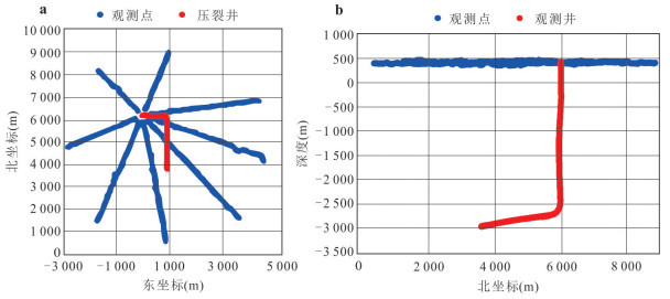
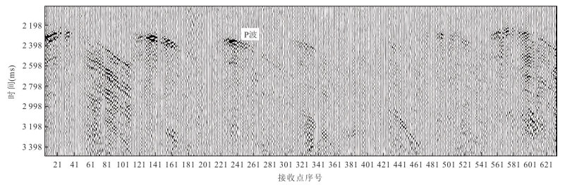
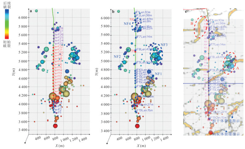
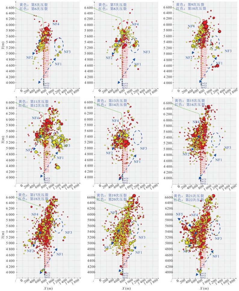
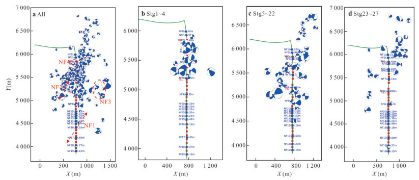
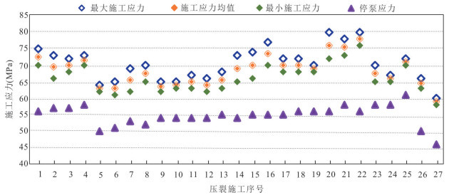
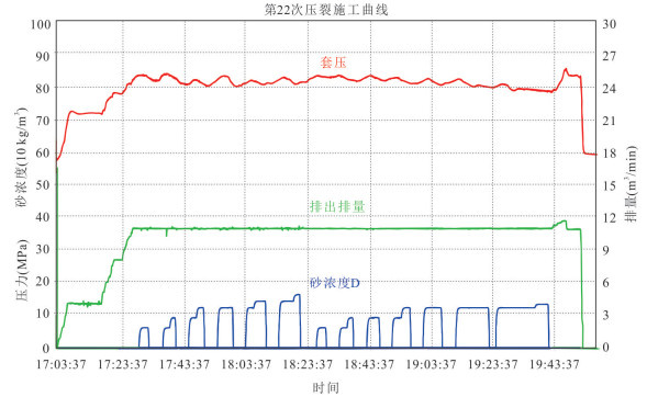
Due to the modification by ultra-long section and multi-stage complex geological tectonic processes, pre-existing fractures and faults are extremely developed in the southern Sichuan shale, which not only reduce fracturing efficiency but also cause casing deformation and increased economic losses; therefore, for high-risk well segments with extremely developed natural fractures, a multi-stage merged ultra-long stage fracturing mode is implemented to avoid fracturing risks and improve fracturing effectiveness. This study focuses on a well with highly developed fractures in the Weiyuan shale of the Sichuan basin, where pre-existing fractures of various scales are extremely developed throughout the wellbore, indicating significant casing deformation risk during hydraulic fracturing, and after actual casing deformation occurred during hydraulic fracturing, the fracturing plan was adjusted immediately by merging 18 stages into an ultra-long segment of 1 168 m, with 18 fracturing and temporary plugging operations performed on this segment. Based on large-array surface microseismic monitoring, this study characterizes the spatiotemporal propagation characteristics and focal mechanisms of fracture activities, and combined with integrated geological-engineering analysis of microseismic data, 3D seismic data, geological surveys, and logging data, clarifies the implementation effect of ultra-long stage hydraulic fracturing, demonstrating that ultra-long stage hydraulic fracturing can reduce the risk of casing deformation in high-risk areas to a certain extent, though highly fractured zones may act as leakage channels for fracturing fluids in ultra-long stages, leading to insufficient stimulation, while adjusting real-time segmentation and fracturing plans for ultra-longsection fracturing based on microseismic responses is beneficial for both reducing casing deformation risks and improving fracturing stimulation effectiveness.
Due to the modification by ultra-long section and multi-stage complex geological tectonic processes, pre-existing fractures and faults are extremely developed in the southern Sichuan shale, which not only reduce fracturing efficiency but also cause casing deformation and increased economic losses; therefore, for high-risk well segments with extremely developed natural fractures, a multi-stage merged ultra-long stage fracturing mode is implemented to avoid fracturing risks and improve fracturing effectiveness. This study focuses on a well with highly developed fractures in the Weiyuan shale of the Sichuan basin, where pre-existing fractures of various scales are extremely developed throughout the wellbore, indicating significant casing deformation risk during hydraulic fracturing, and after actual casing deformation occurred during hydraulic fracturing, the fracturing plan was adjusted immediately by merging 18 stages into an ultra-long segment of 1 168 m, with 18 fracturing and temporary plugging operations performed on this segment. Based on large-array surface microseismic monitoring, this study characterizes the spatiotemporal propagation characteristics and focal mechanisms of fracture activities, and combined with integrated geological-engineering analysis of microseismic data, 3D seismic data, geological surveys, and logging data, clarifies the implementation effect of ultra-long stage hydraulic fracturing, demonstrating that ultra-long stage hydraulic fracturing can reduce the risk of casing deformation in high-risk areas to a certain extent, though highly fractured zones may act as leakage channels for fracturing fluids in ultra-long stages, leading to insufficient stimulation, while adjusting real-time segmentation and fracturing plans for ultra-longsection fracturing based on microseismic responses is beneficial for both reducing casing deformation risks and improving fracturing stimulation effectiveness.

2025, 50(12): 4764-4782.
doi: 10.3799/dqkx.2025.120
Abstract:
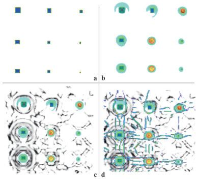
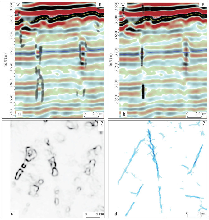
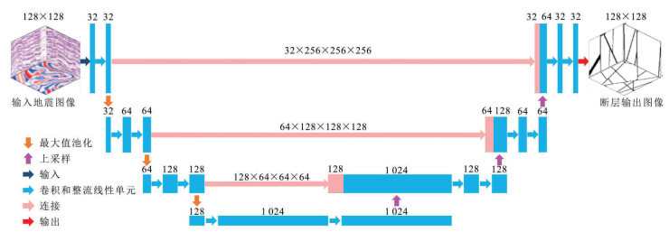
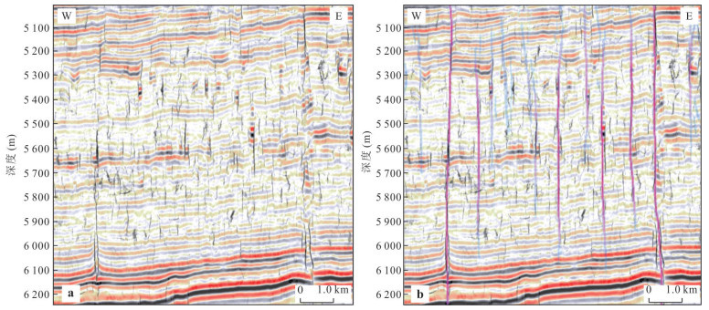
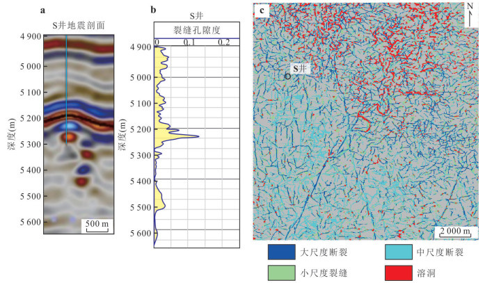
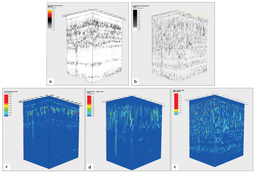
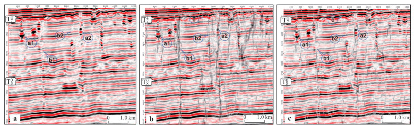
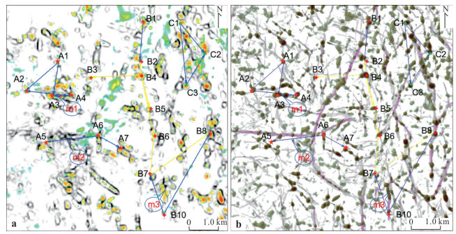
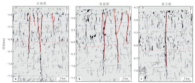
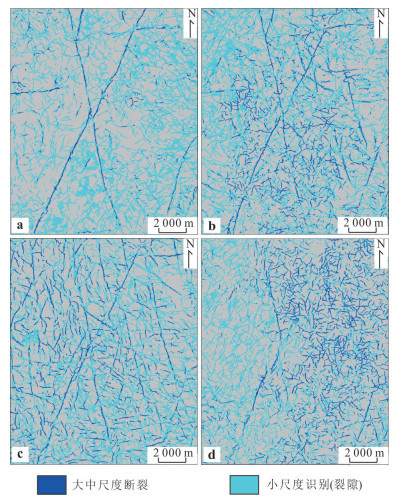
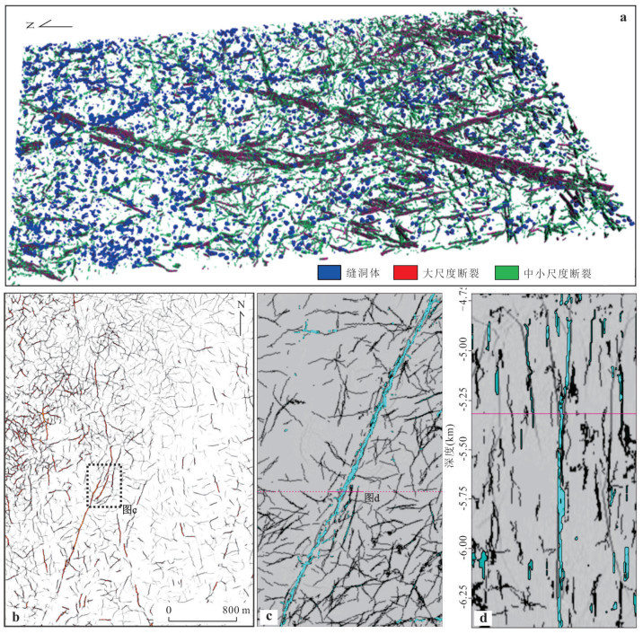
Carbonate reservoirs are important carriers of global oil and gas resources. The development characteristics of their internal karst caves and fault systems directly affect the storage and migration capacity of oil and gas. In order to solve the problem of multi-scale fault prediction in deep and ultra-deep carbonate reservoirs, this study takes the Ordovician carbonate rocks in the Tahe oilfield in the Tarim basin as an example and proposes a classification and grading fault prediction technology based on seismic wave field characteristic analysis. The interference mechanism of large-scale fracture-cavity bodies on conventional fault prediction attributes (such as coherence and maximum likelihood) is revealed through three-dimensional forward simulation, and it is found that the "beaded" reflection anomaly at the boundary of the fracture-cavity body will lead to false connectivity of faults and relocation deviation. Based on the differences in the scale and dissolution characteristics of the faults, the fault system in the study area is divided into large-scale broken-dissolution faults (> 20 m), medium-scale weak-undissolved faults (10-20 m) and small-scale fractures (< 10 m), and targeted prediction methods are developed for each of them: for large-scale faults, a fracture retrieval technology based on gradient structural tensor thinning is proposed to effectively overcome the interference of abnormal boundaries of karst caves; for medium-scale faults, the longitudinal continuity of the faults is significantly improved by combining AFE coherent enhancement attributes with U-Net deep learning algorithm; for small-scale fractures, the Likelihood attribute and structural guidance filtering are used to accurately extract weak reflection signals. Further, a well control multi-attribute fusion model is constructed by fusing multi-scale fault attributes and drilling loss data through deep feed forward neural network (DFNN). The application results show that this technology system has achieved full-scale characterization of the fault system in the complex fracture-cave area of Tahe oilfield. Large-scale strike-slip faults are distributed in a conjugate NNE-NNW direction, medium-scale faults form flower-like structures, and small-scale fractures are densely developed on the active disk (east side) of the fault. This study provides a new technical approach for the prediction of deep carbonate reservoir faults and has important reference value for the exploration and development of similar oil and gas reservoirs.
Carbonate reservoirs are important carriers of global oil and gas resources. The development characteristics of their internal karst caves and fault systems directly affect the storage and migration capacity of oil and gas. In order to solve the problem of multi-scale fault prediction in deep and ultra-deep carbonate reservoirs, this study takes the Ordovician carbonate rocks in the Tahe oilfield in the Tarim basin as an example and proposes a classification and grading fault prediction technology based on seismic wave field characteristic analysis. The interference mechanism of large-scale fracture-cavity bodies on conventional fault prediction attributes (such as coherence and maximum likelihood) is revealed through three-dimensional forward simulation, and it is found that the "beaded" reflection anomaly at the boundary of the fracture-cavity body will lead to false connectivity of faults and relocation deviation. Based on the differences in the scale and dissolution characteristics of the faults, the fault system in the study area is divided into large-scale broken-dissolution faults (> 20 m), medium-scale weak-undissolved faults (10-20 m) and small-scale fractures (< 10 m), and targeted prediction methods are developed for each of them: for large-scale faults, a fracture retrieval technology based on gradient structural tensor thinning is proposed to effectively overcome the interference of abnormal boundaries of karst caves; for medium-scale faults, the longitudinal continuity of the faults is significantly improved by combining AFE coherent enhancement attributes with U-Net deep learning algorithm; for small-scale fractures, the Likelihood attribute and structural guidance filtering are used to accurately extract weak reflection signals. Further, a well control multi-attribute fusion model is constructed by fusing multi-scale fault attributes and drilling loss data through deep feed forward neural network (DFNN). The application results show that this technology system has achieved full-scale characterization of the fault system in the complex fracture-cave area of Tahe oilfield. Large-scale strike-slip faults are distributed in a conjugate NNE-NNW direction, medium-scale faults form flower-like structures, and small-scale fractures are densely developed on the active disk (east side) of the fault. This study provides a new technical approach for the prediction of deep carbonate reservoir faults and has important reference value for the exploration and development of similar oil and gas reservoirs.
2025, 50(12): 4783-4800.
doi: 10.3799/dqkx.2025.185
Abstract:
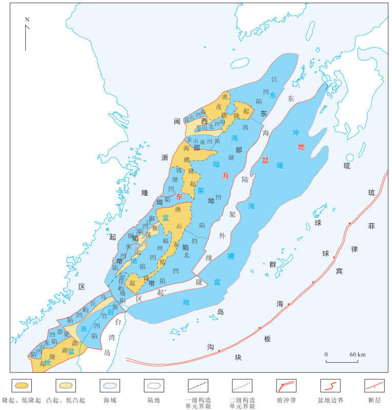
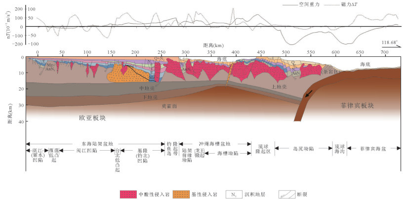
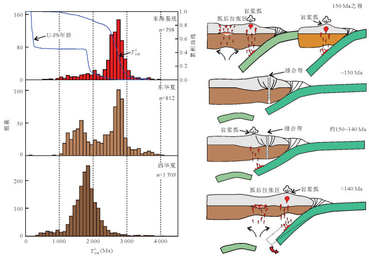
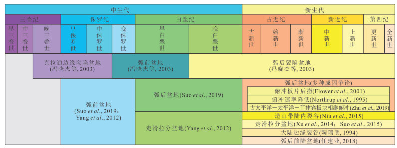
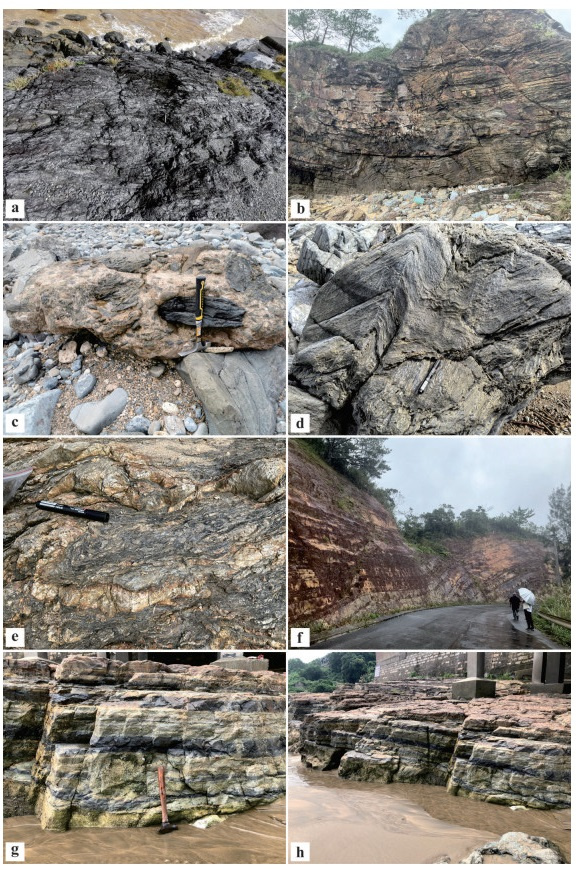
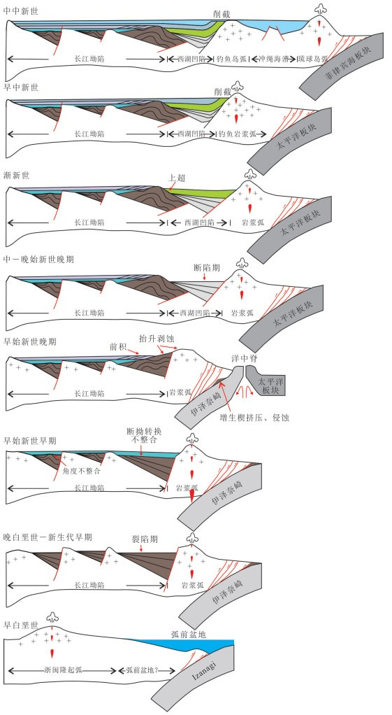
As a critical region for the tectonic evolution of the East Asian continental margin, the East China Sea basin has long been debated regarding its basement attributes, subduction processes, and multi-phase tectonic-sedimentary coupling mechanisms. Based on a comprehensive analysis of existing geological and geophysical data, combined with previous evidence and insights, in this paper it systematically summarizes and evaluates key fundamental geological issues of the East China Sea basin, proposing future research directions. The basement controversy centers on two hypotheses: the extension of the South China continental crust versus the accretion of exotic terranes. Abrupt crustal thickness variations and zircon isotopic data provide new evidence for the latter, but the spatiotemporal constraints on crustal evolution and collisional orogenic belts remain unresolved. The Mesozoic subduction process exhibits staged evolution, including low-angle subduction, slab detachment, and magmatic arc migration. The discovery of Early Jurassic island arc magmatic rocks revises the traditional flat-slab subduction model, yet direct evidence for Cretaceous and Cenozoic magmatic arc positions in offshore areas is still lacking, significantly hindering the understanding of Mesozoic basin nature and evolution. The Cenozoic basin architecture in the north is controlled by slab rollback, while the southern region may correlate closely with the South China Sea spreading, though critical evidence linking subduction and South China Sea extension processes is still needed. The Mesozoic paleogeographic framework remains ambiguous, while abrupt Cenozoic provenance shifts and differential tectonic-sedimentary responses are prominent. Current research lacks systematic comparisons of geological evidence among the South China continent, the East China Sea Basin, and the Ryukyu Islands. Future studies should integrate deep geophysical exploration, high-precision geochronology, and numerical modeling to establish a "subduction-magmatism-sedimentation" co-evolution model, providing theoretical support for hydrocarbon exploration and continental margin dynamics research.
As a critical region for the tectonic evolution of the East Asian continental margin, the East China Sea basin has long been debated regarding its basement attributes, subduction processes, and multi-phase tectonic-sedimentary coupling mechanisms. Based on a comprehensive analysis of existing geological and geophysical data, combined with previous evidence and insights, in this paper it systematically summarizes and evaluates key fundamental geological issues of the East China Sea basin, proposing future research directions. The basement controversy centers on two hypotheses: the extension of the South China continental crust versus the accretion of exotic terranes. Abrupt crustal thickness variations and zircon isotopic data provide new evidence for the latter, but the spatiotemporal constraints on crustal evolution and collisional orogenic belts remain unresolved. The Mesozoic subduction process exhibits staged evolution, including low-angle subduction, slab detachment, and magmatic arc migration. The discovery of Early Jurassic island arc magmatic rocks revises the traditional flat-slab subduction model, yet direct evidence for Cretaceous and Cenozoic magmatic arc positions in offshore areas is still lacking, significantly hindering the understanding of Mesozoic basin nature and evolution. The Cenozoic basin architecture in the north is controlled by slab rollback, while the southern region may correlate closely with the South China Sea spreading, though critical evidence linking subduction and South China Sea extension processes is still needed. The Mesozoic paleogeographic framework remains ambiguous, while abrupt Cenozoic provenance shifts and differential tectonic-sedimentary responses are prominent. Current research lacks systematic comparisons of geological evidence among the South China continent, the East China Sea Basin, and the Ryukyu Islands. Future studies should integrate deep geophysical exploration, high-precision geochronology, and numerical modeling to establish a "subduction-magmatism-sedimentation" co-evolution model, providing theoretical support for hydrocarbon exploration and continental margin dynamics research.
2025, 50(12): 4801-4818.
doi: 10.3799/dqkx.2025.172
Abstract:
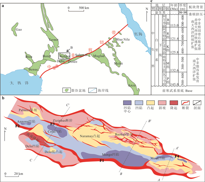
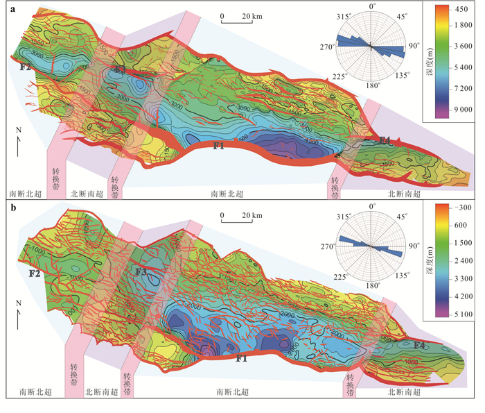
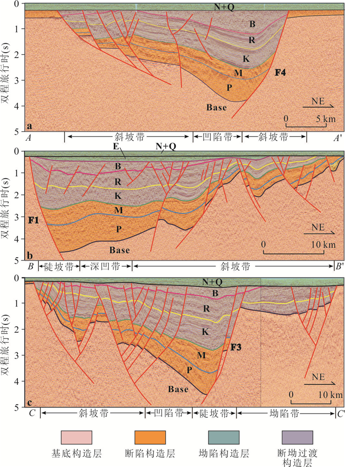
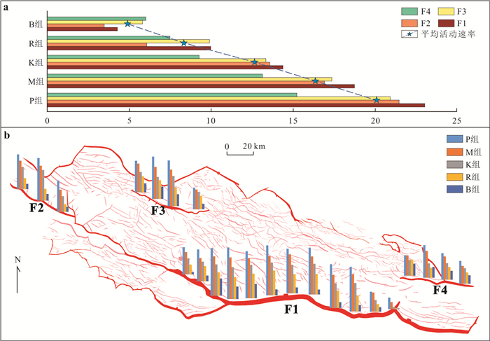
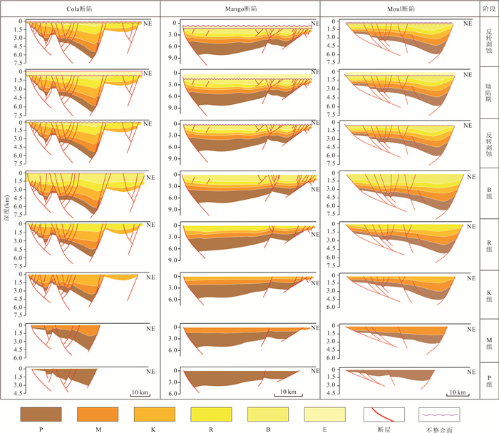
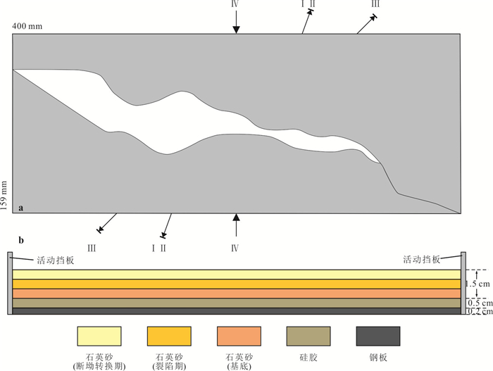
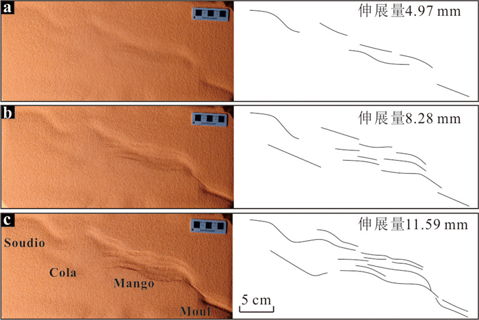
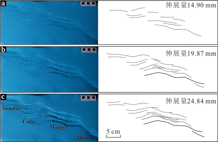
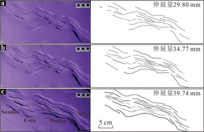
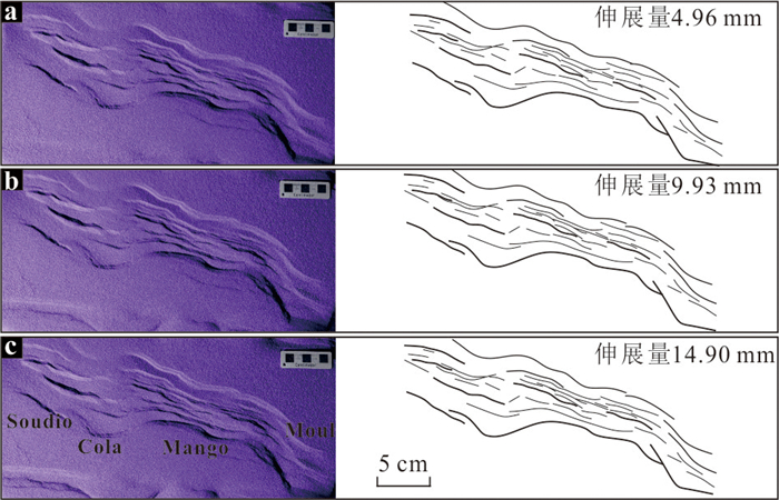
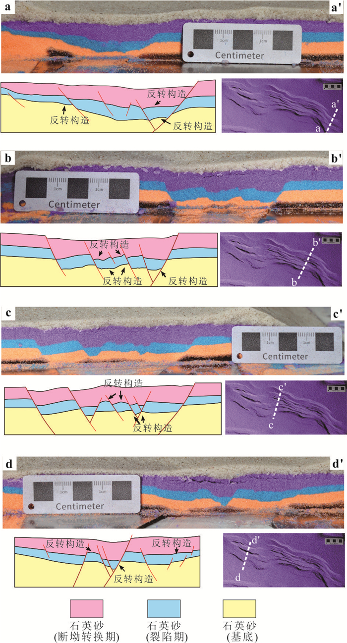
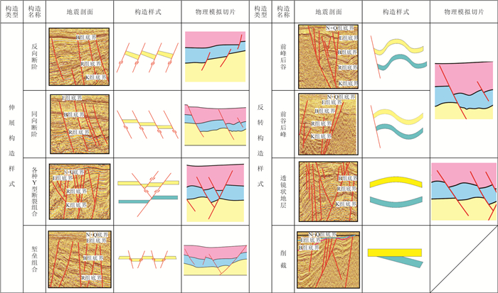
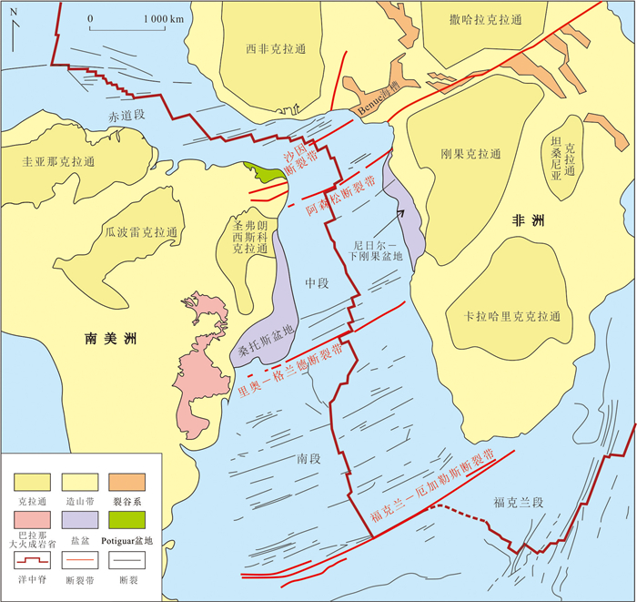
Integrating detailed seismic interpretation and analogue tectonic modeling experiments, this study investigates the unique structural characteristics and the dynamic formation and evolution mechanisms of the Bongor basin in the Central African shear zone. Geophysical interpretation indicates that the Bongor Basin exhibits characteristics of a typical inverted rift basin. The current structural configuration was controlled by two phases rifting during Early Cretaceous and the compression in Late Cretaceous-Paleogene, with the primary rift-related structures are still clearly identifiable. Multi-stage analogue tectonic modeling further confirm that the formation of the Bongor basin was controlled by two early phases of rifting and subsequent inversion, with the extension directions of the two rifting stages separated by 25°-45°. Combining these results and context of regional tectonic history, a geological model of the two-phase rifting in the Bongor basin was put forward. In the early Early Cretaceous, the opening of the South Atlantic Ocean triggered near north-south stretching between the South African and the Northeast African subplate. This led to the first phase of rifting in the Central African rift system basins, including the Bongor basin. During the late Early Cretaceous, both the shift of the main Atlantic expansion toward the equatorial region and the subduction of the Tethys Ocean toward the Eurasian continent caused a nearly northeast-southwest extensional stress between the Northeast African block and the South African block. Unlike other basins parallel to the Central African rift system, the northwest-trending Bongor basin underwent a second phase of rifting. The study presents new insights into the formation and evolution of the Bongor basin, which is of great significance for guiding future oil and gas exploration.
Integrating detailed seismic interpretation and analogue tectonic modeling experiments, this study investigates the unique structural characteristics and the dynamic formation and evolution mechanisms of the Bongor basin in the Central African shear zone. Geophysical interpretation indicates that the Bongor Basin exhibits characteristics of a typical inverted rift basin. The current structural configuration was controlled by two phases rifting during Early Cretaceous and the compression in Late Cretaceous-Paleogene, with the primary rift-related structures are still clearly identifiable. Multi-stage analogue tectonic modeling further confirm that the formation of the Bongor basin was controlled by two early phases of rifting and subsequent inversion, with the extension directions of the two rifting stages separated by 25°-45°. Combining these results and context of regional tectonic history, a geological model of the two-phase rifting in the Bongor basin was put forward. In the early Early Cretaceous, the opening of the South Atlantic Ocean triggered near north-south stretching between the South African and the Northeast African subplate. This led to the first phase of rifting in the Central African rift system basins, including the Bongor basin. During the late Early Cretaceous, both the shift of the main Atlantic expansion toward the equatorial region and the subduction of the Tethys Ocean toward the Eurasian continent caused a nearly northeast-southwest extensional stress between the Northeast African block and the South African block. Unlike other basins parallel to the Central African rift system, the northwest-trending Bongor basin underwent a second phase of rifting. The study presents new insights into the formation and evolution of the Bongor basin, which is of great significance for guiding future oil and gas exploration.
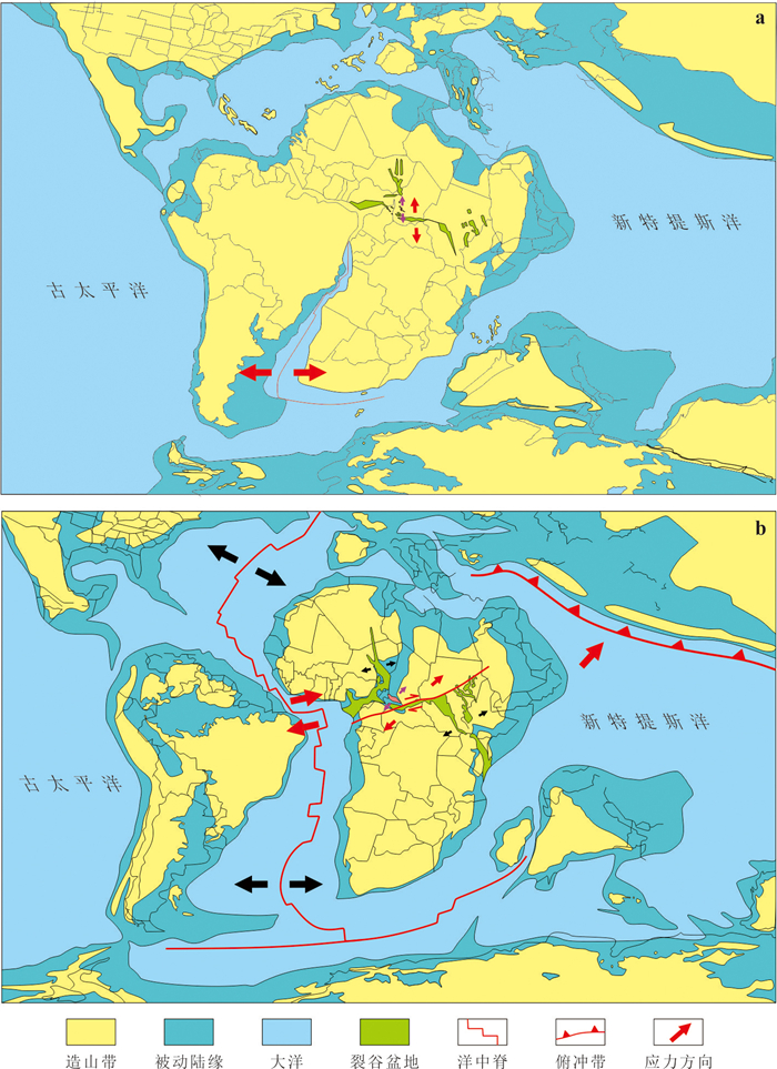
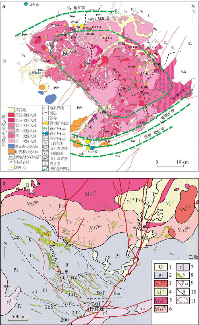
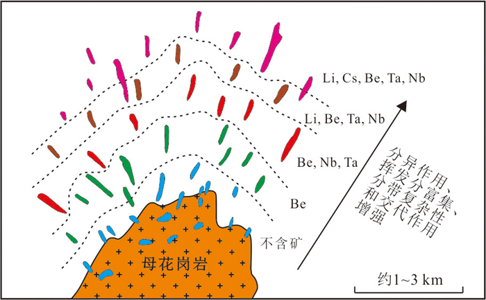
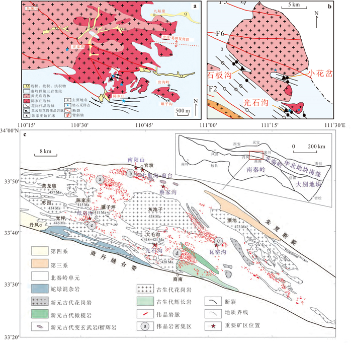
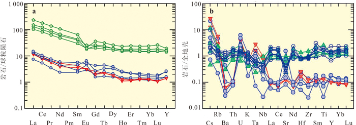
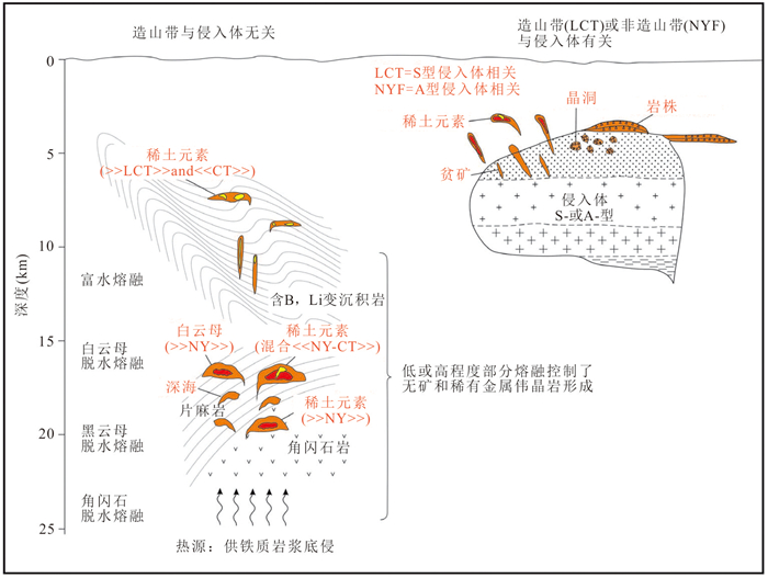
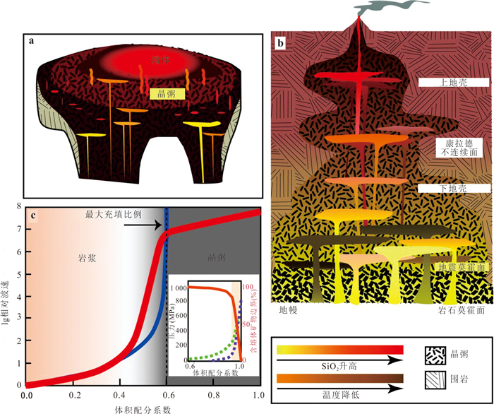
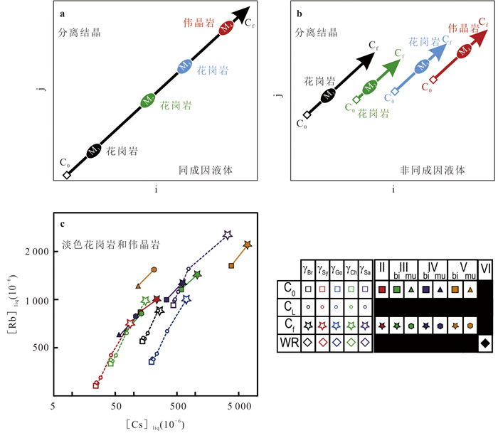
2025, 50(12): 4819-4878.
doi: 10.3799/dqkx.2025.018
Abstract:
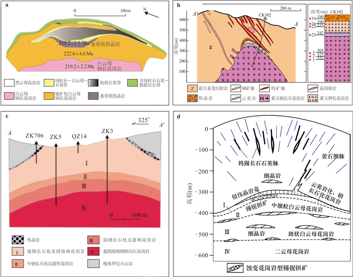
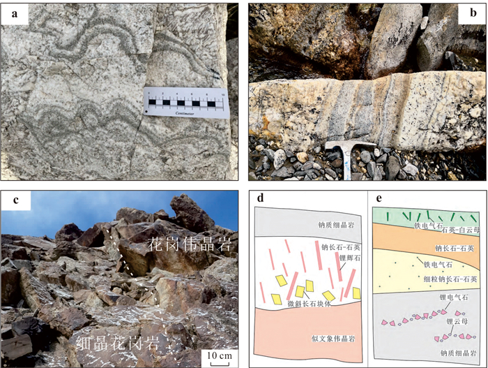
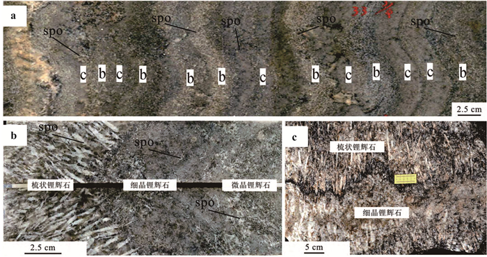
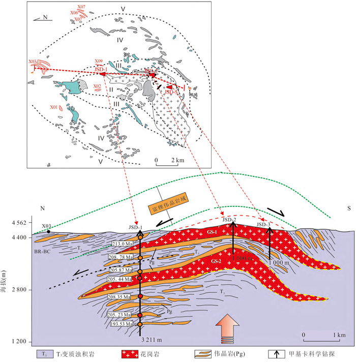
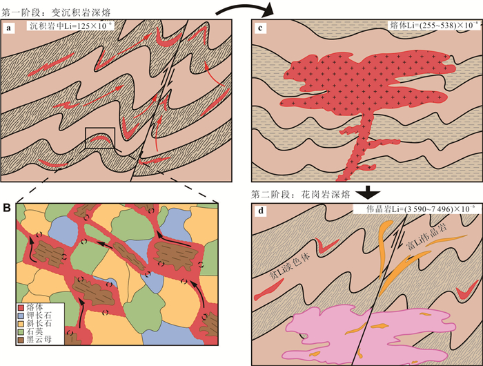
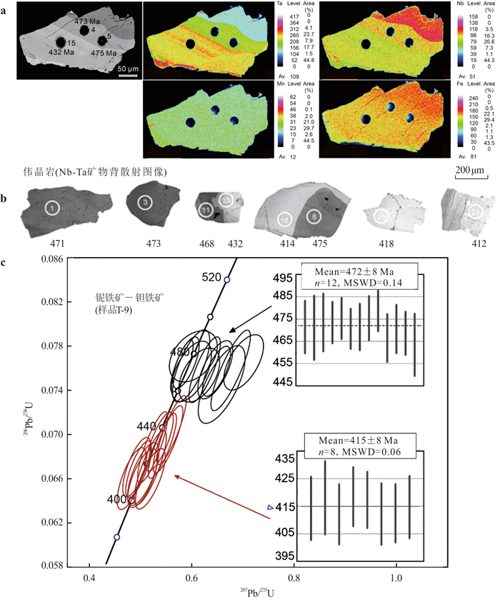
Many recent studies indicate that the relationship between granitic pegmatite and granite is complex and can be summarized simply into four types: "Father-son relationship", i.e. granitic pegmatites are the late products of highly differentiated and evolved granitic magma; "Brotherly relationship", granitic pegmatite and granite are the products of simultaneous or near-simultaneous independent crystallization of magma with similar compositions; "Indirect relationship", formation of rare metal pegmatites through multi-stage partial melting of source granite; "No relationship between granitic pegmatite and granite", relative big time-gap and different source materials for pegmatite and granite are displayed in many pegmatite fields, and anatectic individual pegmatite magma is a reasonable genetic model. Crystal mush reservoir and trans-crustal magmatic system are the important for understanding the relationship between pegmatite and granite. Inheritance (or detrital) minerals for dating and isobaric interference for analysis of hafnium isotopic composition should be pay more attention for the study on the relationship between pegmatite and granite. The establishment and development of techniques and reference materials for isotopic dating need to be enhanced. The study on characteristics and mechanism of non-traditional isotope fractionation during the differentiation and evolution of granitic magma should be strengthened. Petro-geochemical analysis and large-scale mapping of the granite batholith are suggested in order to give more valid evidences for the rare metal pegmatite exploration.
Many recent studies indicate that the relationship between granitic pegmatite and granite is complex and can be summarized simply into four types: "Father-son relationship", i.e. granitic pegmatites are the late products of highly differentiated and evolved granitic magma; "Brotherly relationship", granitic pegmatite and granite are the products of simultaneous or near-simultaneous independent crystallization of magma with similar compositions; "Indirect relationship", formation of rare metal pegmatites through multi-stage partial melting of source granite; "No relationship between granitic pegmatite and granite", relative big time-gap and different source materials for pegmatite and granite are displayed in many pegmatite fields, and anatectic individual pegmatite magma is a reasonable genetic model. Crystal mush reservoir and trans-crustal magmatic system are the important for understanding the relationship between pegmatite and granite. Inheritance (or detrital) minerals for dating and isobaric interference for analysis of hafnium isotopic composition should be pay more attention for the study on the relationship between pegmatite and granite. The establishment and development of techniques and reference materials for isotopic dating need to be enhanced. The study on characteristics and mechanism of non-traditional isotope fractionation during the differentiation and evolution of granitic magma should be strengthened. Petro-geochemical analysis and large-scale mapping of the granite batholith are suggested in order to give more valid evidences for the rare metal pegmatite exploration.

2025, 50(12): 4879-4893.
doi: 10.3799/dqkx.2025.212
Abstract:
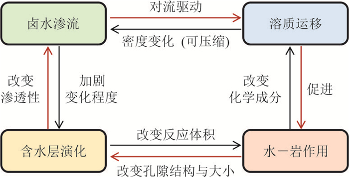
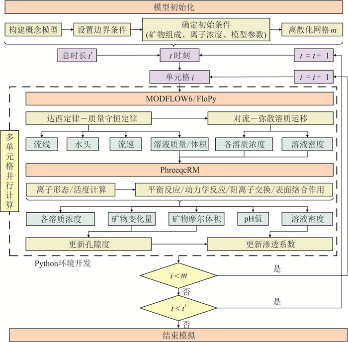
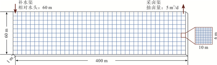
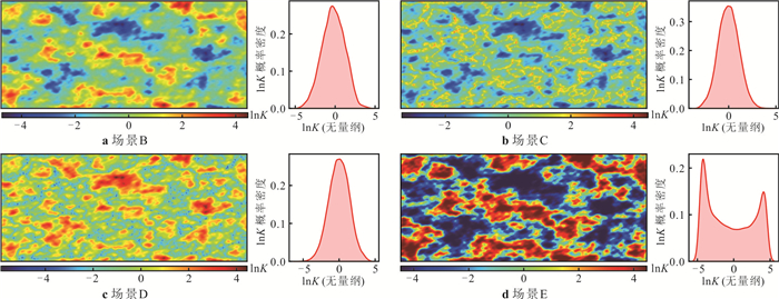
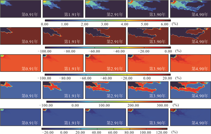
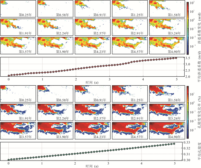
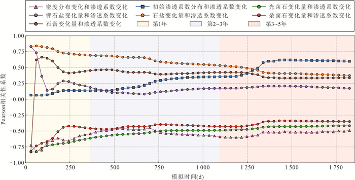
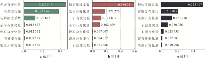
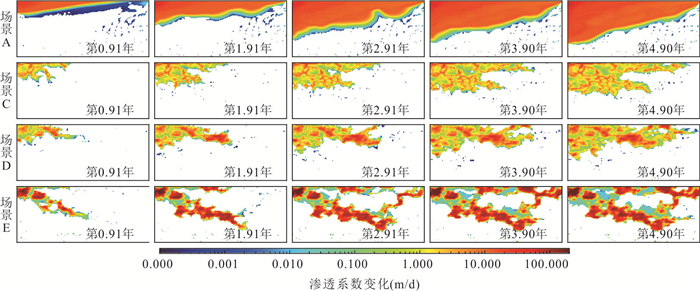
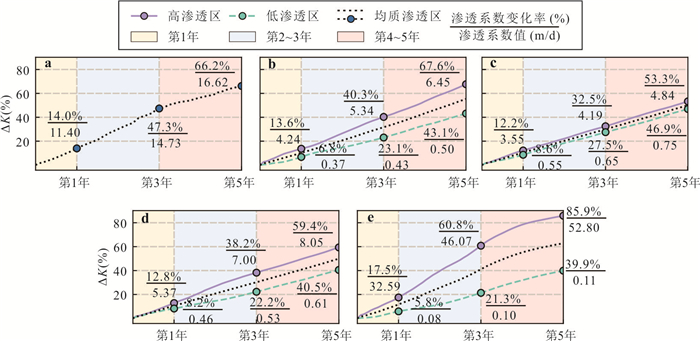
Artificial solution mining technology, which converts evaporite minerals in brine aquifers into brine, is crucial for the sustainable development of salt lake resources. However, the dynamic evolution of aquifer hydraulic conductivity induced by mineral dissolution during water injection remains insufficiently understood, hindering accurate process prediction. In this study, a Python-based modeling tool, MF6PQC, coupling MODFLOW6 and PhreeqcRM, was developed to systematically investigate the effects of reactive transport on the hydraulic conductivity of brine aquifers and the overall solution mining process. Simulation results show that aquifer heterogeneity governs the spatiotemporal evolution of hydraulic conductivity. During the early stage of dissolution mining, hydrogeochemical reactions preferentially occur in high permeability zones. The dissolution of highly reactive minerals such as carnallite significantly enhances porosity and hydraulic conductivity, ultimately forming preferential flow paths driven by positive advection-dispersion feedback. Relatively homogeneous aquifers or those with extensive, well-connected high-permeability zones facilitate uniform lixiviant distribution and achieve higher solid-to-liquid conversion efficiency. In contrast, strongly preferential or poorly connected formations interrupted by low permeability barriers limit mineral contact and dissolution, thereby reducing overall solution mining efficiency. This study deepens the understanding of hydraulic conductivity evolution in brine aquifers during water injection and provides a theoretical basis for optimizing salt lake brine resource exploitation.
Artificial solution mining technology, which converts evaporite minerals in brine aquifers into brine, is crucial for the sustainable development of salt lake resources. However, the dynamic evolution of aquifer hydraulic conductivity induced by mineral dissolution during water injection remains insufficiently understood, hindering accurate process prediction. In this study, a Python-based modeling tool, MF6PQC, coupling MODFLOW6 and PhreeqcRM, was developed to systematically investigate the effects of reactive transport on the hydraulic conductivity of brine aquifers and the overall solution mining process. Simulation results show that aquifer heterogeneity governs the spatiotemporal evolution of hydraulic conductivity. During the early stage of dissolution mining, hydrogeochemical reactions preferentially occur in high permeability zones. The dissolution of highly reactive minerals such as carnallite significantly enhances porosity and hydraulic conductivity, ultimately forming preferential flow paths driven by positive advection-dispersion feedback. Relatively homogeneous aquifers or those with extensive, well-connected high-permeability zones facilitate uniform lixiviant distribution and achieve higher solid-to-liquid conversion efficiency. In contrast, strongly preferential or poorly connected formations interrupted by low permeability barriers limit mineral contact and dissolution, thereby reducing overall solution mining efficiency. This study deepens the understanding of hydraulic conductivity evolution in brine aquifers during water injection and provides a theoretical basis for optimizing salt lake brine resource exploitation.
2025, 50(12): 4894-4908.
doi: 10.3799/dqkx.2025.110
Abstract:
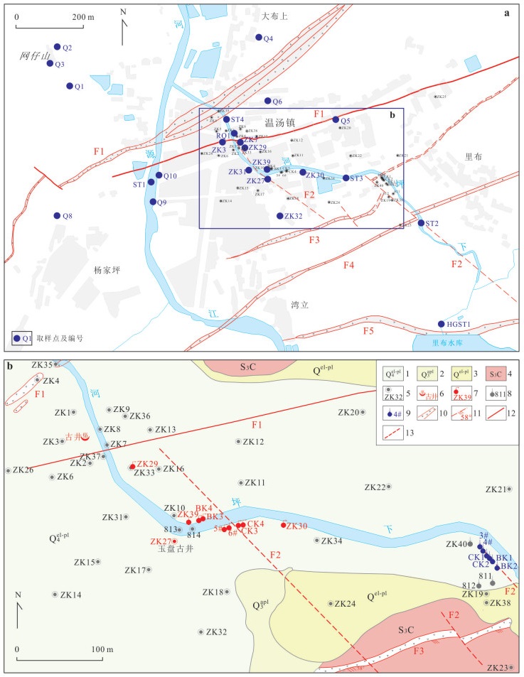
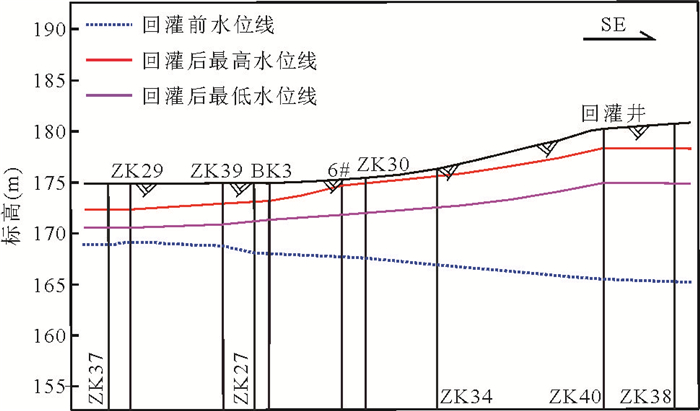
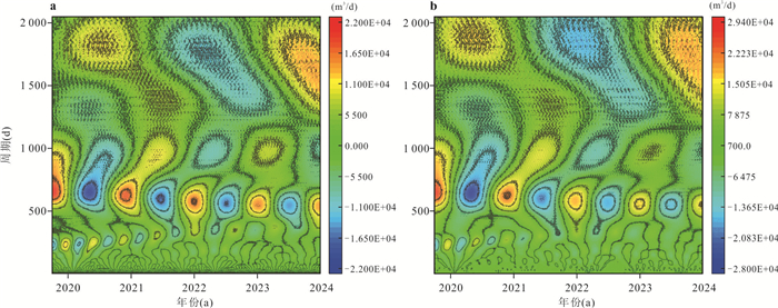
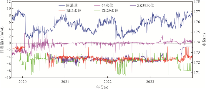
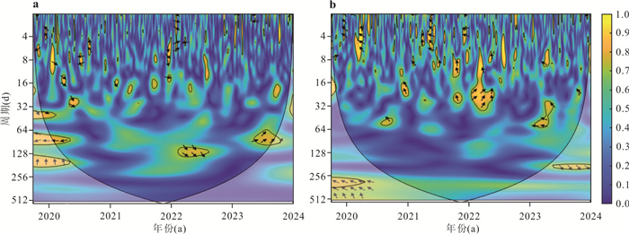
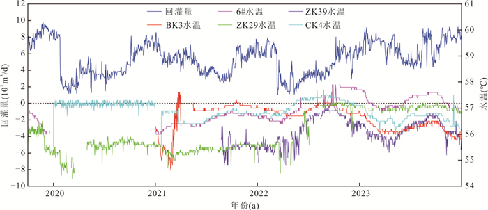
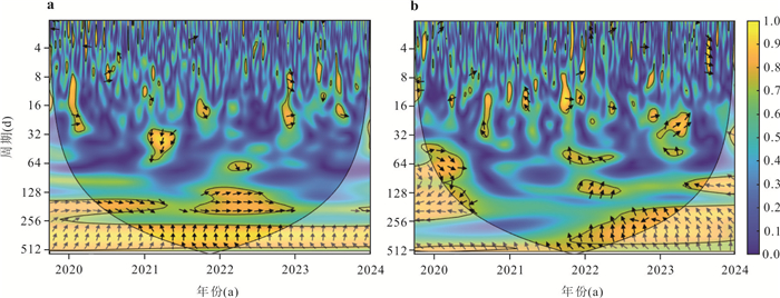
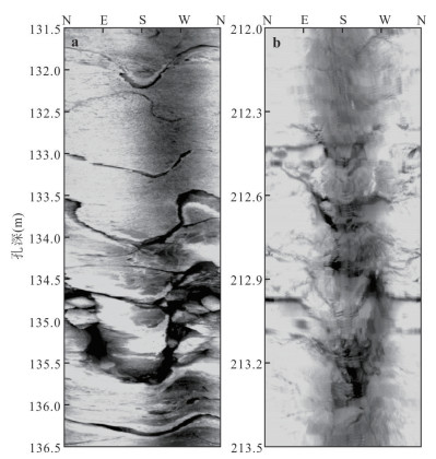
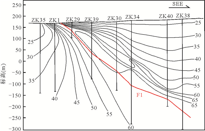
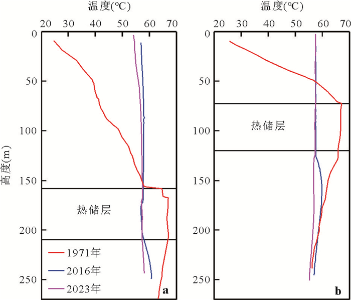
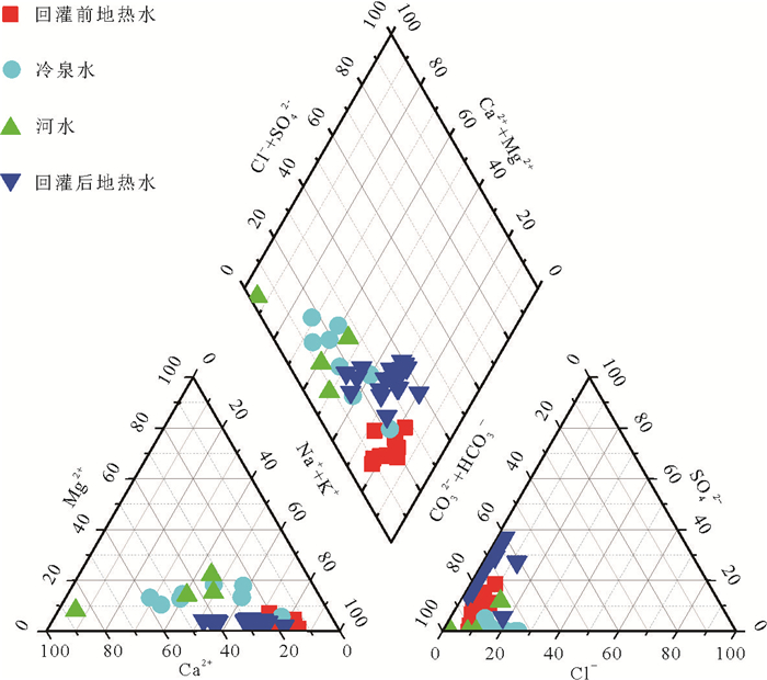
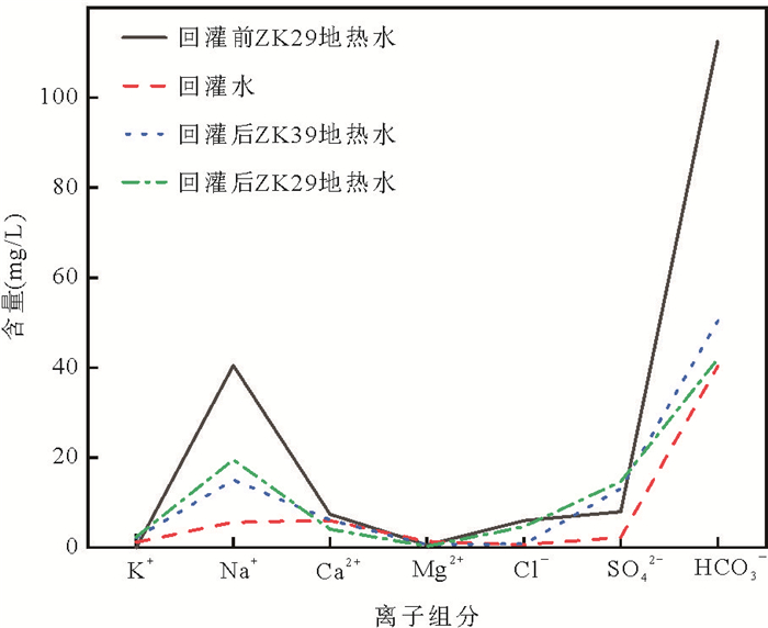
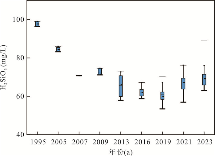
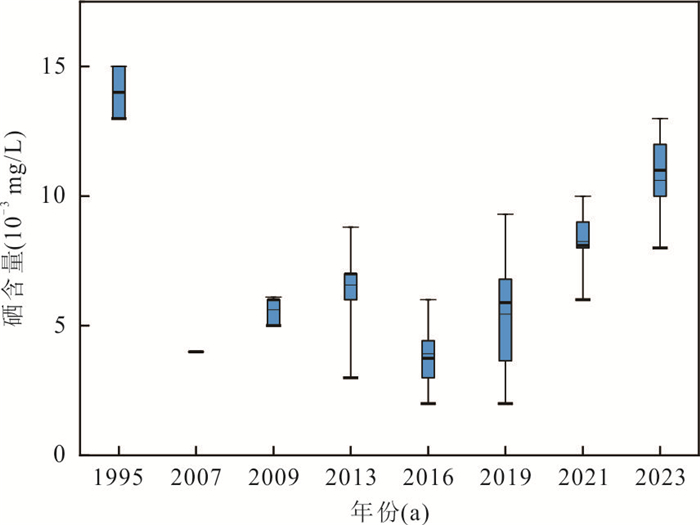
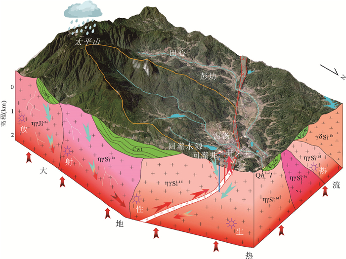
Fractured geothermal reservoir reinjection has garnered significant attention for its remarkable effectiveness in enhancing geothermal water supply capacity, raising water levels, and mitigating resource and environmental issues associated with geothermal exploitation. This study focuses on the Yichun Wentang geothermal field, employing time series analysis and hydrogeochemical methods to analyze long-term monitoring data of reinjection volume, extraction volume, water temperature, water level, and water quality during surface water reinjection and extraction processes. The study summarizes the dynamic variations in the geothermal field's temperature field, fluid field, and chemical field, and investigates the sustainability and safety of long-term reinjection in fractured reservoirs. The results indicate that reinjection volume is the primary factor influencing the dynamic changes in the temperature, fluid, and chemical fields. Long-term reinjection raises the geothermal field's water level by 3.952-4.986 m, increases the dynamic amplitude of water level fluctuations by 13.4 times, and reverses the planar distribution direction of water levels. When the reinjection volume remains below the threshold, the production well's water temperature exhibits an inverse correlation with reinjection volume, delayed by 3-12 months; exceeding the threshold leads to a "cliff-like" decline in temperature. Long-term reinjection causes an overall decrease in well temperatures, with a maximum reduction of 6.8-10.0 ℃, though stabilization occurs after controlling reinjection volume. Reinjection water directly "dilutes" geothermal water, shifting hydrochemical types in the Piper diagram toward surface water characteristics, transitioning from HCO3-Na type to HCO3·SO4-Na·Ca type. Long-term monitoring confirms that the geothermal field remains safe and controllable when reinjection volume is maintained below 9, 734 m3/d, increasing resource availability by 414%. Surface water reinjection in fractured reservoirs demonstrates good feasibility and safety, provided the reinjection volume does not exceed the threshold.
Fractured geothermal reservoir reinjection has garnered significant attention for its remarkable effectiveness in enhancing geothermal water supply capacity, raising water levels, and mitigating resource and environmental issues associated with geothermal exploitation. This study focuses on the Yichun Wentang geothermal field, employing time series analysis and hydrogeochemical methods to analyze long-term monitoring data of reinjection volume, extraction volume, water temperature, water level, and water quality during surface water reinjection and extraction processes. The study summarizes the dynamic variations in the geothermal field's temperature field, fluid field, and chemical field, and investigates the sustainability and safety of long-term reinjection in fractured reservoirs. The results indicate that reinjection volume is the primary factor influencing the dynamic changes in the temperature, fluid, and chemical fields. Long-term reinjection raises the geothermal field's water level by 3.952-4.986 m, increases the dynamic amplitude of water level fluctuations by 13.4 times, and reverses the planar distribution direction of water levels. When the reinjection volume remains below the threshold, the production well's water temperature exhibits an inverse correlation with reinjection volume, delayed by 3-12 months; exceeding the threshold leads to a "cliff-like" decline in temperature. Long-term reinjection causes an overall decrease in well temperatures, with a maximum reduction of 6.8-10.0 ℃, though stabilization occurs after controlling reinjection volume. Reinjection water directly "dilutes" geothermal water, shifting hydrochemical types in the Piper diagram toward surface water characteristics, transitioning from HCO3-Na type to HCO3·SO4-Na·Ca type. Long-term monitoring confirms that the geothermal field remains safe and controllable when reinjection volume is maintained below 9, 734 m3/d, increasing resource availability by 414%. Surface water reinjection in fractured reservoirs demonstrates good feasibility and safety, provided the reinjection volume does not exceed the threshold.
2025, 50(12): 4909-4918.
doi: 10.3799/dqkx.2025.154
Abstract:
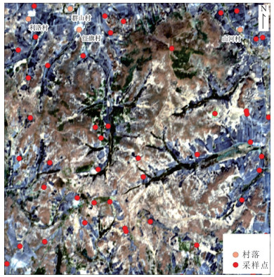
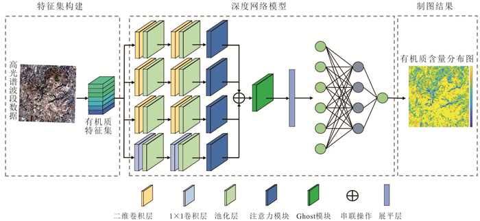
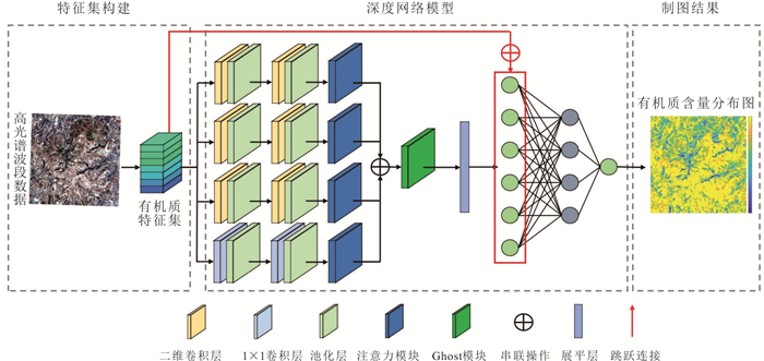
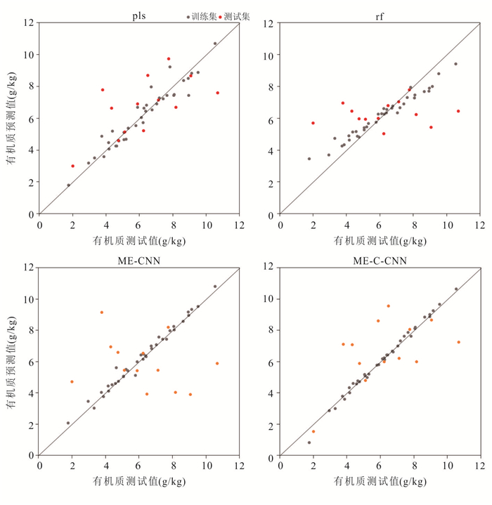
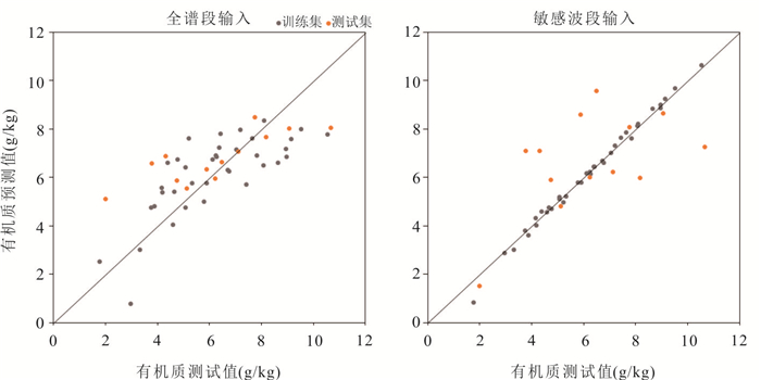
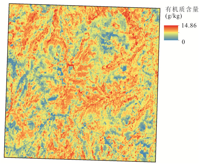
The northeastern black soil region, recognized as a critical grain-producing area in China, has experienced a continuous decline in soil organic matter (SOM) content in recent years. The application of hyperspectral remote sensing technology for SOM content retrieval plays a crucial role in assessing the current status of black soil and implementing conservation measures. To address the low retrieval accuracy resulting from scale discrepancies in spatial and spectral characteristics of black soil, this study developed a remote sensing retrieval model with multi-scale feature enhancement. By constructing a multi-scale feature enhancement structure, spectral features were systematically extracted at different scales. Furthermore, skip connections were incorporated to effectively integrate initial spectral features with deep hierarchical features derived from convolutional networks, thereby strengthening the model's spectral representation capacity. When benchmarked against traditional methods such as partial least squares regression and random forest models, the proposed model demonstrates enhanced capability in capturing multi-scale black soil features and establishing spectral relationships. This advancement enables accurate SOM content retrieval under complex conditions, providing both theoretical significance and practical value for advancing intelligent remote sensing retrieval and sustainable conservation of black soil resources.
The northeastern black soil region, recognized as a critical grain-producing area in China, has experienced a continuous decline in soil organic matter (SOM) content in recent years. The application of hyperspectral remote sensing technology for SOM content retrieval plays a crucial role in assessing the current status of black soil and implementing conservation measures. To address the low retrieval accuracy resulting from scale discrepancies in spatial and spectral characteristics of black soil, this study developed a remote sensing retrieval model with multi-scale feature enhancement. By constructing a multi-scale feature enhancement structure, spectral features were systematically extracted at different scales. Furthermore, skip connections were incorporated to effectively integrate initial spectral features with deep hierarchical features derived from convolutional networks, thereby strengthening the model's spectral representation capacity. When benchmarked against traditional methods such as partial least squares regression and random forest models, the proposed model demonstrates enhanced capability in capturing multi-scale black soil features and establishing spectral relationships. This advancement enables accurate SOM content retrieval under complex conditions, providing both theoretical significance and practical value for advancing intelligent remote sensing retrieval and sustainable conservation of black soil resources.
2025, 50(12): 4919-4937.
doi: 10.3799/dqkx.2025.166
Abstract:
Under global climate warming scenarios, permafrost degradation has triggered retrogressive thaw slumps, posing threats to engineering infrastructure and ecological security in cold regions. However, many scholars lack sufficient understanding of the morphological characteristics and evolutionary processes of RTSs (retrogressive thaw slumps), and the applicability of simulation models has not been systematically summarized. In this study, RTSs from four perspectives: morphology, evolution, destabilization mechanisms, and simulation methods, based on field investigation and literature analysis. The main findings include: (1) The morphological characteristics of RTSs can be classified into 11 types, and their spatial distribution is associated with topographic features, permafrost conditions, and developmental stages. (2) The evolution of RTSs experiences four stages: surface cracking, active layer detachment, polycyclic recession, and gradual stabilization, mainly affected by ground ice and extreme climatic events. (3) The instability of RTSs is the result of the interaction among thermal-hydrological-mechanical fields. Under the influence of the stress field, moisture and heat transfer are affected, while the temperature and moisture fields determine the pore water pressure, which in turn influences the stress field and change slope stability. (4) The limit equilibrium method, numerical simulation, and uncertainty analysis are the main methods for simulating permafrost stability, each with its own advantages and limitations. This study enhances the understanding of the phenomena and processes of RTSs. It is of great significance for revealing the interaction mechanisms among permafrost, climate, and geomorphology, and provides support for the improvement of theoretical frameworks in cold-region geomorphology, permafrost mechanics, and related disciplines.
Under global climate warming scenarios, permafrost degradation has triggered retrogressive thaw slumps, posing threats to engineering infrastructure and ecological security in cold regions. However, many scholars lack sufficient understanding of the morphological characteristics and evolutionary processes of RTSs (retrogressive thaw slumps), and the applicability of simulation models has not been systematically summarized. In this study, RTSs from four perspectives: morphology, evolution, destabilization mechanisms, and simulation methods, based on field investigation and literature analysis. The main findings include: (1) The morphological characteristics of RTSs can be classified into 11 types, and their spatial distribution is associated with topographic features, permafrost conditions, and developmental stages. (2) The evolution of RTSs experiences four stages: surface cracking, active layer detachment, polycyclic recession, and gradual stabilization, mainly affected by ground ice and extreme climatic events. (3) The instability of RTSs is the result of the interaction among thermal-hydrological-mechanical fields. Under the influence of the stress field, moisture and heat transfer are affected, while the temperature and moisture fields determine the pore water pressure, which in turn influences the stress field and change slope stability. (4) The limit equilibrium method, numerical simulation, and uncertainty analysis are the main methods for simulating permafrost stability, each with its own advantages and limitations. This study enhances the understanding of the phenomena and processes of RTSs. It is of great significance for revealing the interaction mechanisms among permafrost, climate, and geomorphology, and provides support for the improvement of theoretical frameworks in cold-region geomorphology, permafrost mechanics, and related disciplines.
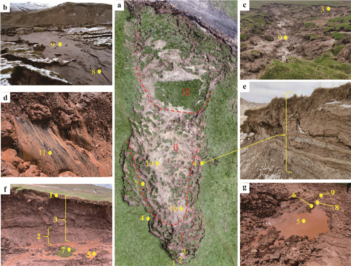
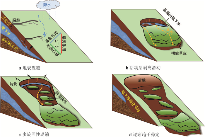
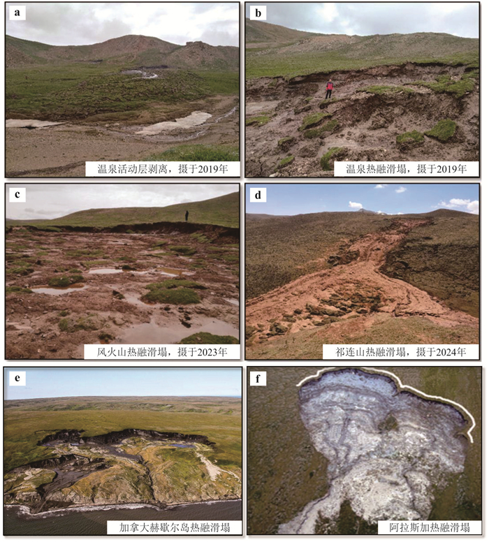
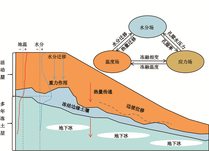
2025, 50(12): 4938-4949.
doi: 10.3799/dqkx.2025.200
Abstract:
The formation mechanism of dolomite [CaMg(CO3)2] remains a longstanding enigma in earth sciences. Previous studies have identified certain microorganisms and clay minerals as catalysts in the crystallization of low-temperature protodolomite, a crucial precursor to ordered dolomite. However, the role of cyanobacteria and particularly their potential synergistic effects with clay minerals remain poorly understood. In this study, we investigated bioprecipitation of carbonate minerals using the halotolerant cyanobacterium Synechococcus elongatus FACHB-410 in the presence and absence of montmorillonite. Our results demonstrated that protodolomite occurred as the predominant solid product in the montmorillonite-amended biosystems as confirmed by X-ray diffraction (XRD) and Raman spectroscopy, whereas monohydrocalcite and low-magnesian calcite were the primary products in the montmorillonite-free biosystems. Multiple microscopic techniques, including scanning electron microscopy (SEM), focused ion beam microscopy (FIB-SEM), and transmission electron microscopy (TEM), revealed that protodolomite nucleated as nanocrystals preferentially on montmorillonite surfaces. Density functional theory (DFT) simulations further elucidated that surface electronegativity of montmorillonite played a key role in promoting protodolomite formation by strongly adsorbing Mg2+ ions through electrostatic interactions, thereby facilitating their dehydration and significantly lowering the nucleation energy barrier.
The formation mechanism of dolomite [CaMg(CO3)2] remains a longstanding enigma in earth sciences. Previous studies have identified certain microorganisms and clay minerals as catalysts in the crystallization of low-temperature protodolomite, a crucial precursor to ordered dolomite. However, the role of cyanobacteria and particularly their potential synergistic effects with clay minerals remain poorly understood. In this study, we investigated bioprecipitation of carbonate minerals using the halotolerant cyanobacterium Synechococcus elongatus FACHB-410 in the presence and absence of montmorillonite. Our results demonstrated that protodolomite occurred as the predominant solid product in the montmorillonite-amended biosystems as confirmed by X-ray diffraction (XRD) and Raman spectroscopy, whereas monohydrocalcite and low-magnesian calcite were the primary products in the montmorillonite-free biosystems. Multiple microscopic techniques, including scanning electron microscopy (SEM), focused ion beam microscopy (FIB-SEM), and transmission electron microscopy (TEM), revealed that protodolomite nucleated as nanocrystals preferentially on montmorillonite surfaces. Density functional theory (DFT) simulations further elucidated that surface electronegativity of montmorillonite played a key role in promoting protodolomite formation by strongly adsorbing Mg2+ ions through electrostatic interactions, thereby facilitating their dehydration and significantly lowering the nucleation energy barrier.
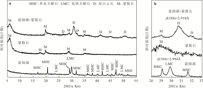
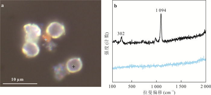
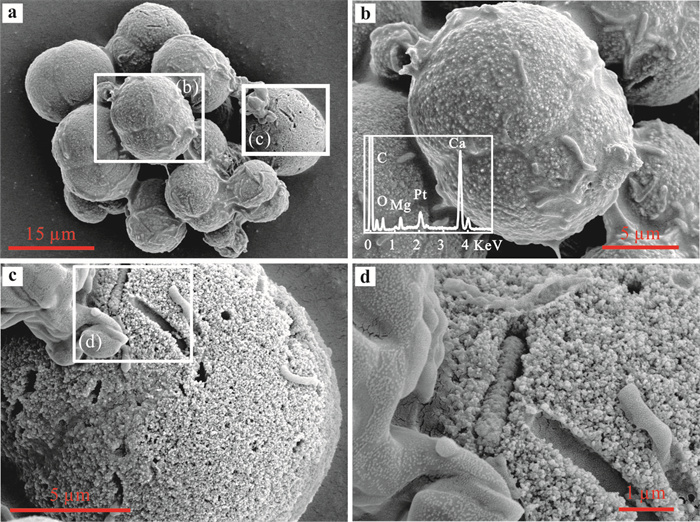
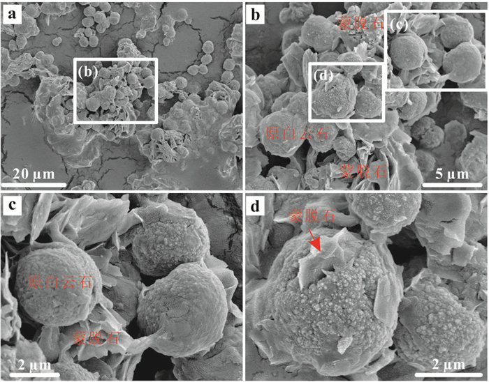
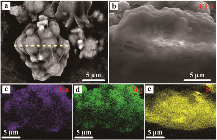
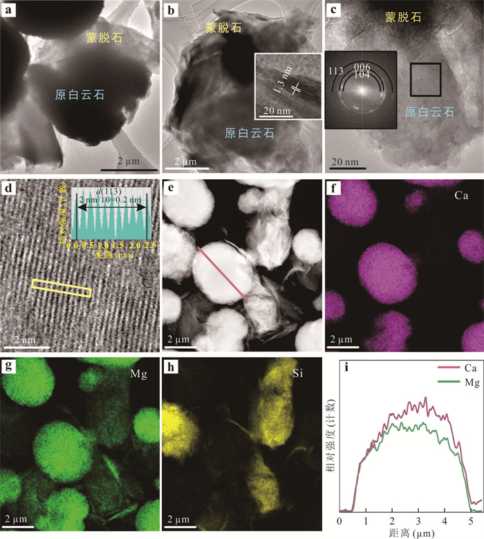
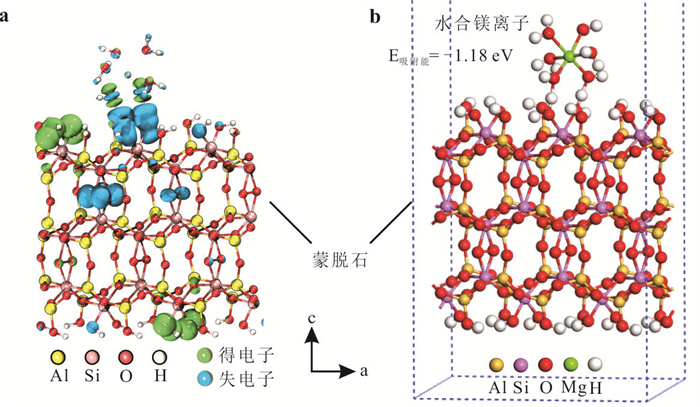
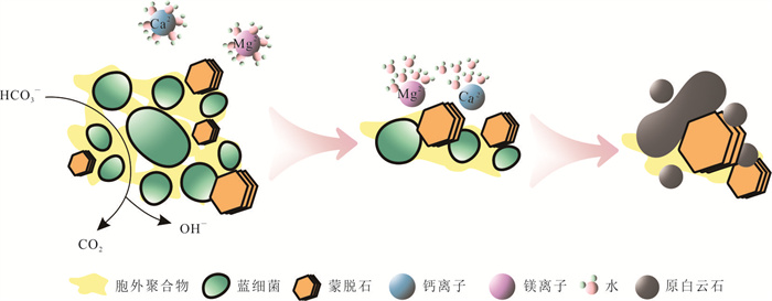
2025, 50(12): 4950-4969.
doi: 10.3799/dqkx.2025.239
Abstract:
On 28 May 2025, a large rock-ice avalanche occurred at the Blatten village in Valais, Switzerland. The failure mobilized approximately 8.3 million m3 of material, traveled 3 300 m, and deposited over an area of 2.66 km2. The Blatten avalanche caused one fatality, buried the Blatten village and dammed the Lonza River. Integrating remote sensing analysis, seismic signal interpretation and numerical modeling, this study reconstructs the event and identifies its pronounced cascade amplification effects. The failure evolved through three distinct stages: high-altitude collapse, glacier melting and deformation, and transformation into a long-runout avalanche. Progressive debris accumulation and gradual glacier weakening were the key drivers of the large-scale hazard. In addition, low-friction ice and meltwater markedly reduced motion resistance, facilitating the long-runout movement. These findings highlight the need to account for the potential of multiple small-scale failures cascading into catastrophic events in avalanche risk assessments. The Blatten disaster offers important implications for hazard zoning and the planning of major infrastructure projects in high-mountain regions of western China.
On 28 May 2025, a large rock-ice avalanche occurred at the Blatten village in Valais, Switzerland. The failure mobilized approximately 8.3 million m3 of material, traveled 3 300 m, and deposited over an area of 2.66 km2. The Blatten avalanche caused one fatality, buried the Blatten village and dammed the Lonza River. Integrating remote sensing analysis, seismic signal interpretation and numerical modeling, this study reconstructs the event and identifies its pronounced cascade amplification effects. The failure evolved through three distinct stages: high-altitude collapse, glacier melting and deformation, and transformation into a long-runout avalanche. Progressive debris accumulation and gradual glacier weakening were the key drivers of the large-scale hazard. In addition, low-friction ice and meltwater markedly reduced motion resistance, facilitating the long-runout movement. These findings highlight the need to account for the potential of multiple small-scale failures cascading into catastrophic events in avalanche risk assessments. The Blatten disaster offers important implications for hazard zoning and the planning of major infrastructure projects in high-mountain regions of western China.
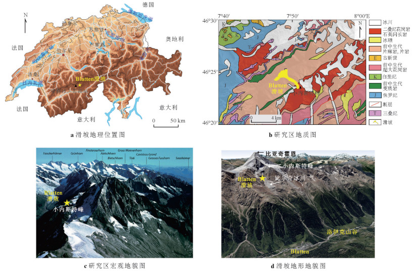
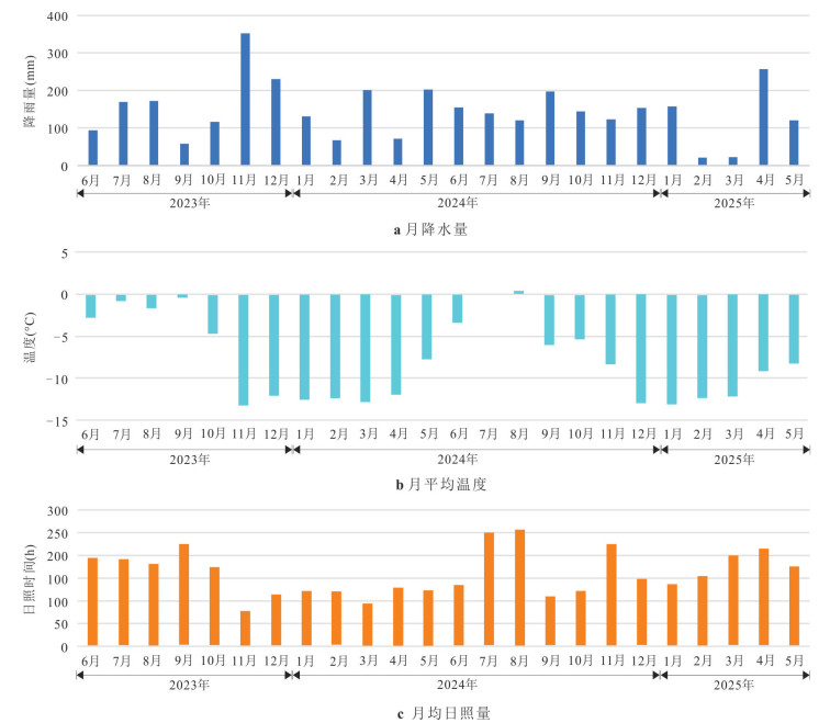
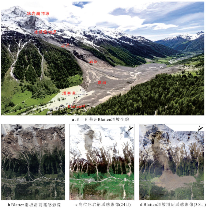
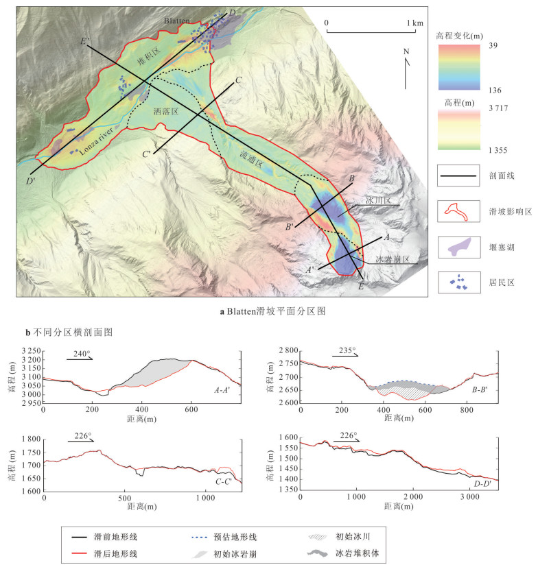
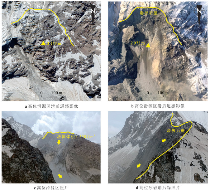
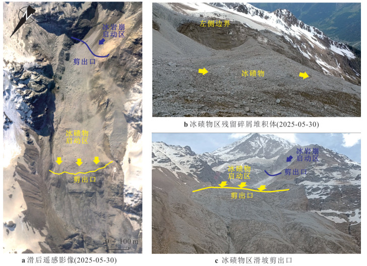
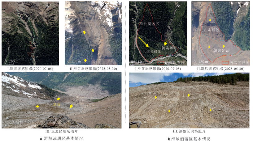
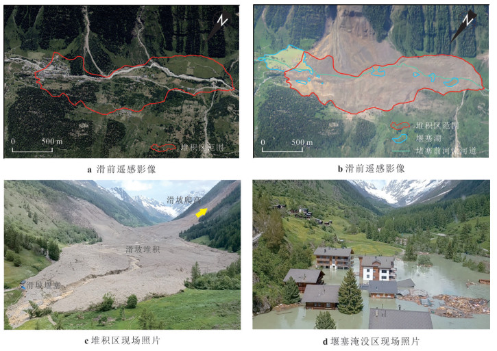
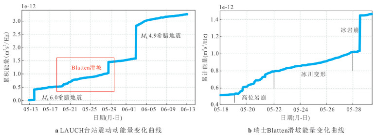
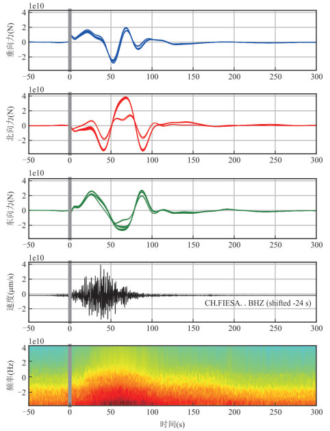
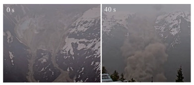
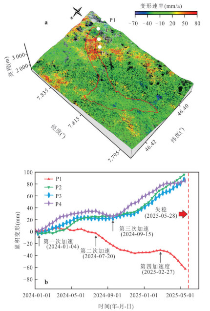
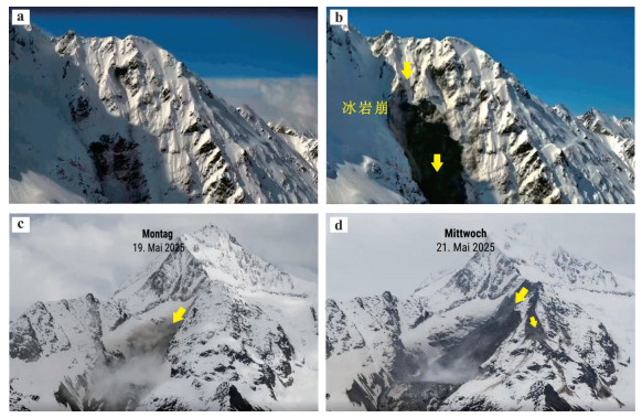
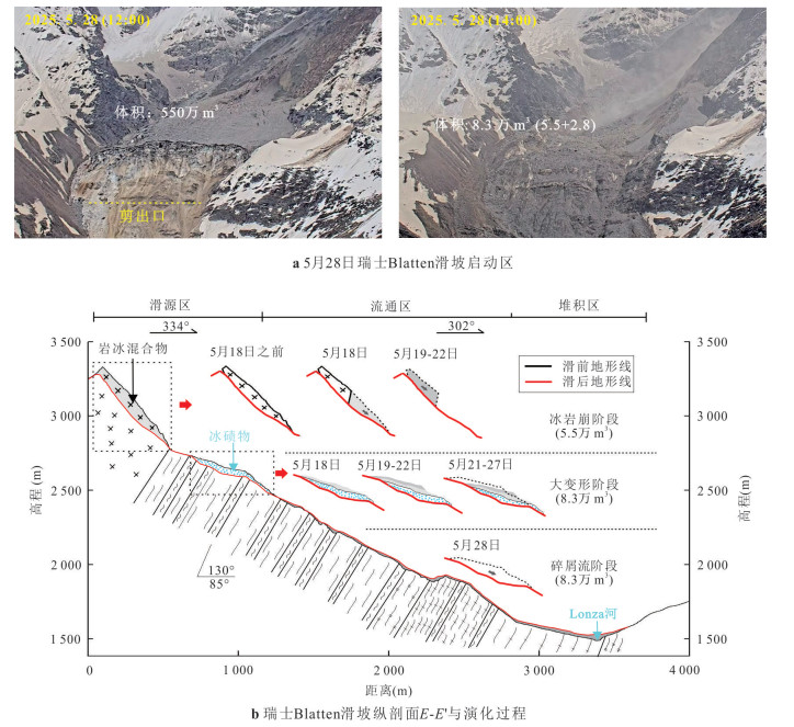
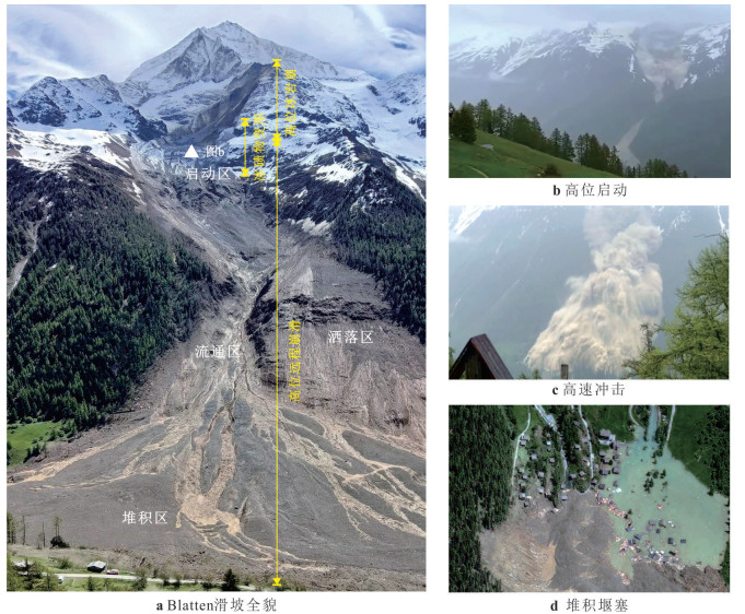
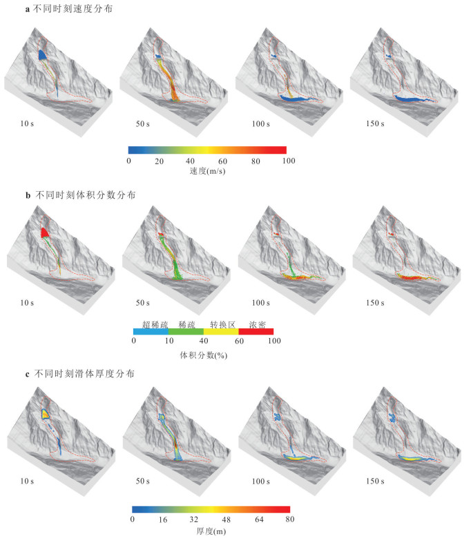
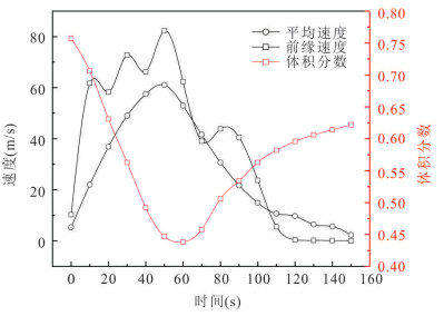
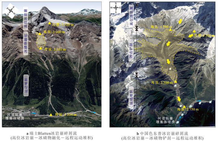
2025, 50(12): 4970-4983.
doi: 10.3799/dqkx.2025.139
Abstract:
The bed failure model is the important initiated model for debris flow in channel. However, there is no detail critical condition for bed failure model. In this paper, a series of laboratory experiments were carried out to study the initiation of debris flow by runoff in the channel. The experiments were conducted for the initiation models and critical condition with different particle size, saturated density, internal friction angle, and permeability coefficient. It was found that the slope threshold of debris flow initiation in bed failure model with no cohesion sediment increased with the increasing of sediment saturation density and internal friction. The minimum slope was about 17 degree in the experiments for the bed failure. When the bed slope is greater than the threshold slope, the thickness of the saturated layer of the bed failure decreases with the increase of the bed slope, the minimum sediment saturation thickness may be 0. The critical discharge of debris flow in fluvial transport model is much larger than that in bed failure model. The critical discharge of debris flow in bed failure model is the production of the permeability coefficient of sediment, the depth of saturated water and the width of channel.
The bed failure model is the important initiated model for debris flow in channel. However, there is no detail critical condition for bed failure model. In this paper, a series of laboratory experiments were carried out to study the initiation of debris flow by runoff in the channel. The experiments were conducted for the initiation models and critical condition with different particle size, saturated density, internal friction angle, and permeability coefficient. It was found that the slope threshold of debris flow initiation in bed failure model with no cohesion sediment increased with the increasing of sediment saturation density and internal friction. The minimum slope was about 17 degree in the experiments for the bed failure. When the bed slope is greater than the threshold slope, the thickness of the saturated layer of the bed failure decreases with the increase of the bed slope, the minimum sediment saturation thickness may be 0. The critical discharge of debris flow in fluvial transport model is much larger than that in bed failure model. The critical discharge of debris flow in bed failure model is the production of the permeability coefficient of sediment, the depth of saturated water and the width of channel.
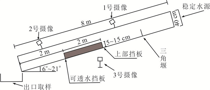
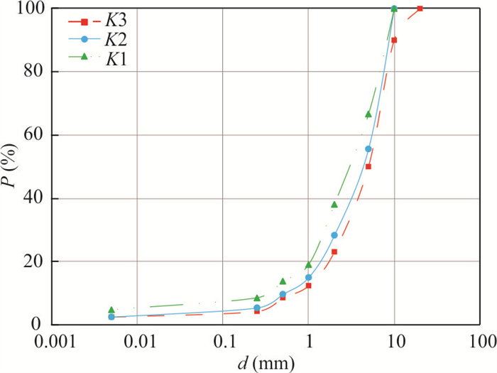
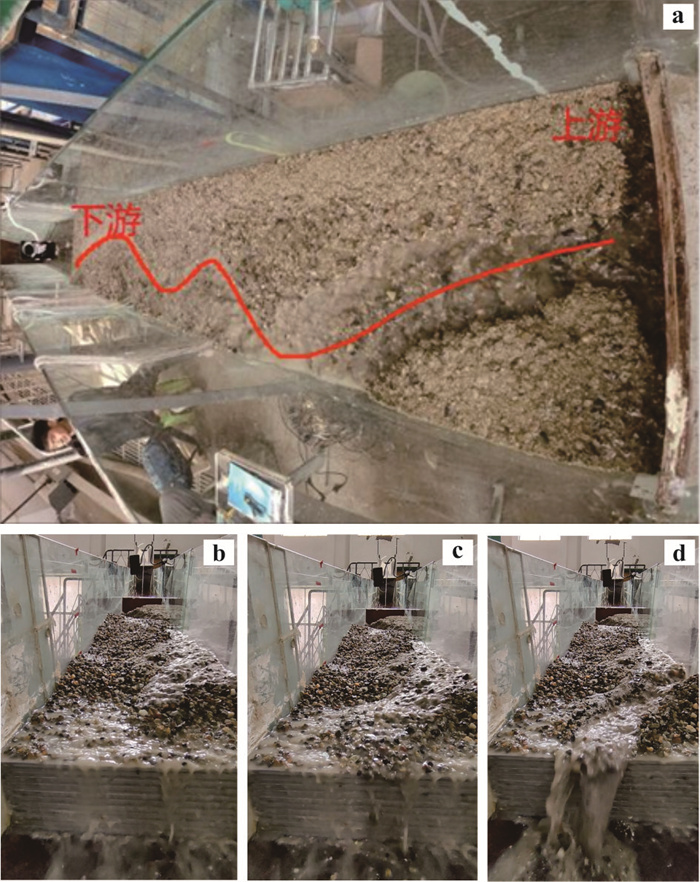
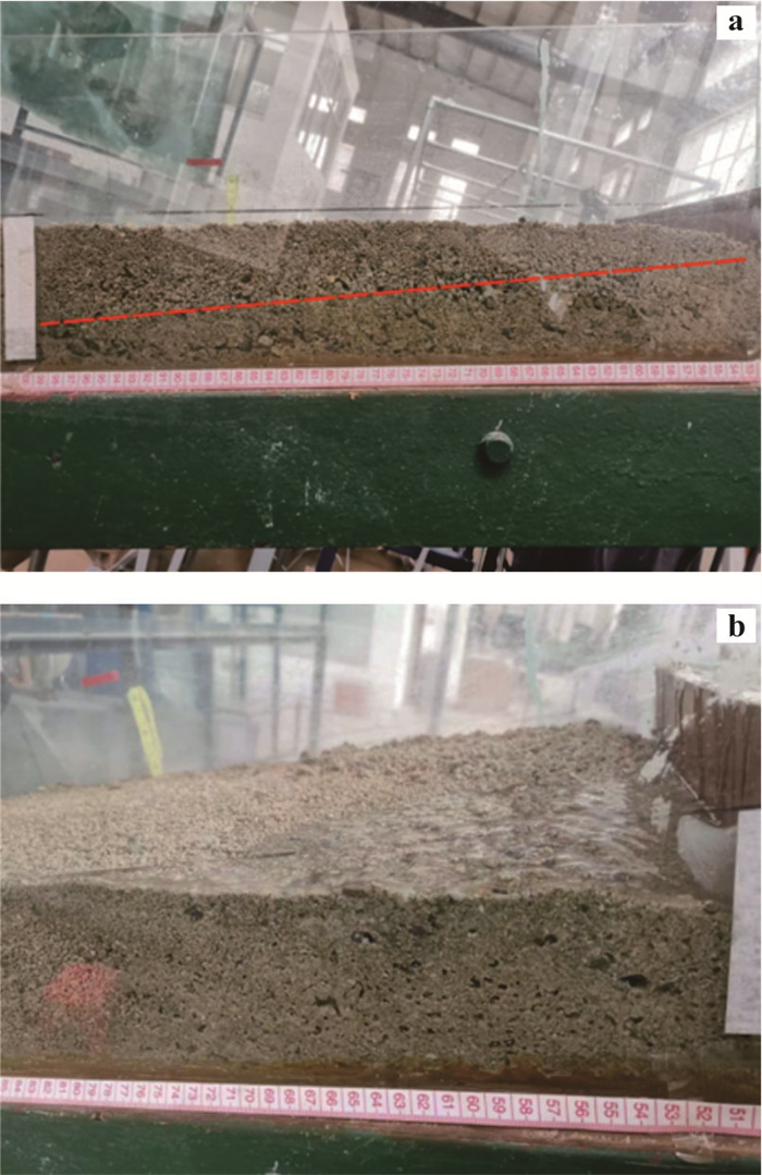
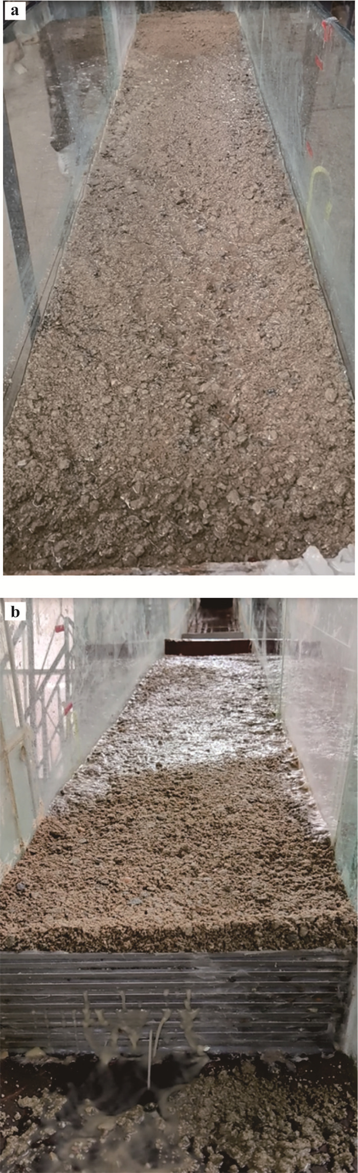
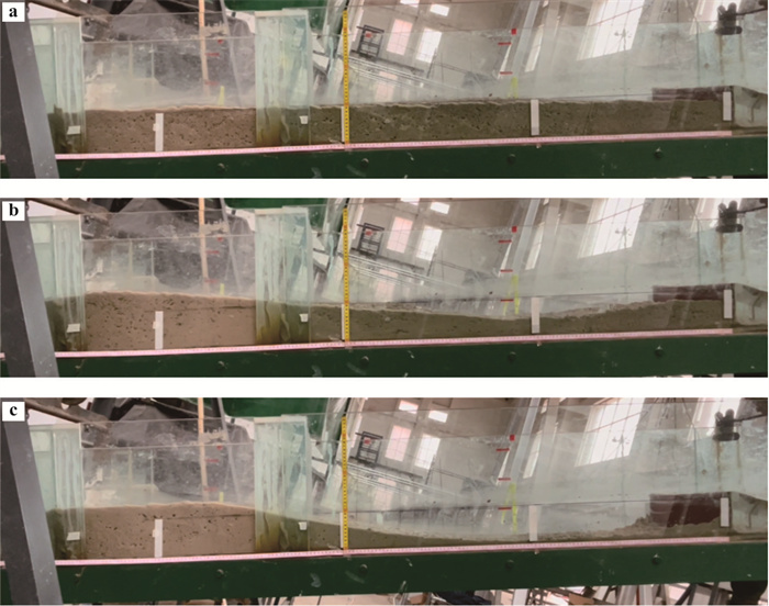
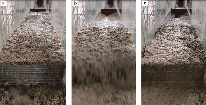
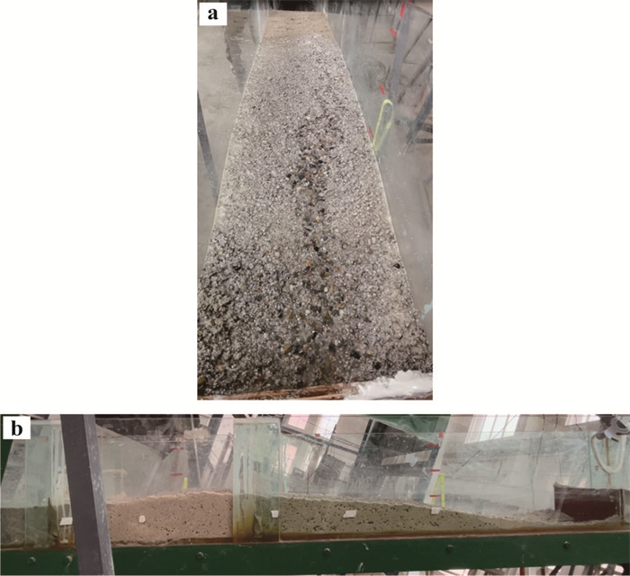
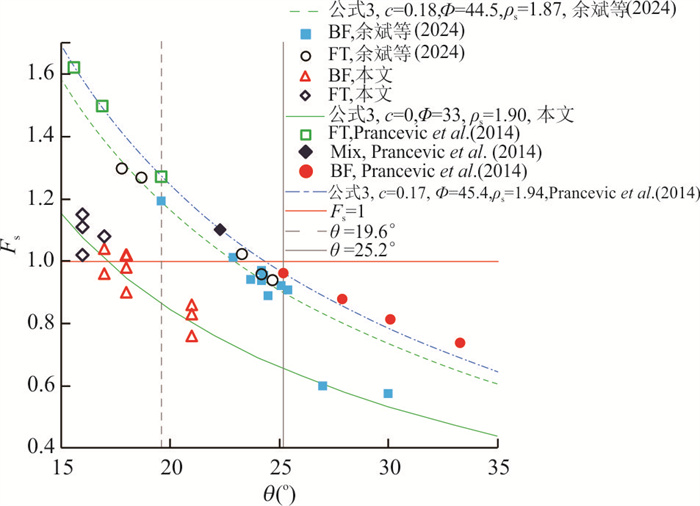
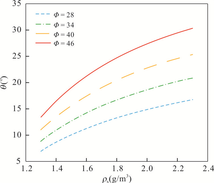
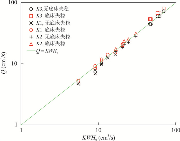
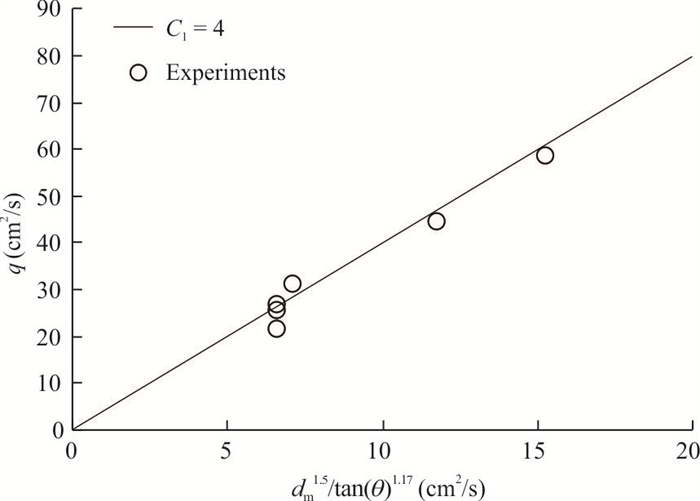
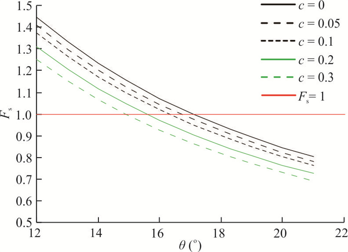
2025, 50(12): 4984-4999.
doi: 10.3799/dqkx.2025.147
Abstract:
Urban solid waste landfill-induced high-steep slope instability often leads to secondary disasters such as extensive building destruction and casualties. To quantitatively evaluate the disaster risk of artificial landfill landslides, this study takes Shenzhen's "12•20" Guangming landslide as a case study, employing the depth-integrated method-based Massflow software to construct a dynamic numerical model that reproduces the entire evolution process of landslide initiation, high-speed movement, and deposition. By coupling with impact pressure calculation methods for landslide masses, the destructive impact effects on surrounding buildings were quantitatively evaluated. An uncertainty analysis framework was introduced, treating geotechnical parameters and sliding surface properties as random variables. A probabilistic analysis model was developed through Latin hypercube sampling, revealing the statistical characteristics of landslide travel distance under multifactorial influences and establishing a correlation model between landslide motion exceedance probability and building impact damage. Building vulnerability was further considered when conducting risk assessments for structures and nearby personnel. The study demonstrates that the depth-integrated method effectively captures the dynamic evolution of landslides, with simulated failure surface morphology, travel distance (1 139 m), and deposition pattern highly consistent with field monitoring data; impact pressure from landslide masses on buildings exhibits a rapid rise to peak values followed by gradual attenuation, with peak pressure decreasing significantly with distance from the landslide source; probabilistic analysis of landslide travel distance based on parameter uncertainty shows the actual deposition zone entirely falls within the 95% confidence interval, and building damage areas align with hazard zoning results. The proposed risk assessment framework integrating depth-integrated modeling and uncertainty analysis provides a novel methodology for quantitative evaluation of engineered landfill landslides, offering significant theoretical and practical implications for solid waste landfill safety management in the context of "zero-waste city" development.
Urban solid waste landfill-induced high-steep slope instability often leads to secondary disasters such as extensive building destruction and casualties. To quantitatively evaluate the disaster risk of artificial landfill landslides, this study takes Shenzhen's "12•20" Guangming landslide as a case study, employing the depth-integrated method-based Massflow software to construct a dynamic numerical model that reproduces the entire evolution process of landslide initiation, high-speed movement, and deposition. By coupling with impact pressure calculation methods for landslide masses, the destructive impact effects on surrounding buildings were quantitatively evaluated. An uncertainty analysis framework was introduced, treating geotechnical parameters and sliding surface properties as random variables. A probabilistic analysis model was developed through Latin hypercube sampling, revealing the statistical characteristics of landslide travel distance under multifactorial influences and establishing a correlation model between landslide motion exceedance probability and building impact damage. Building vulnerability was further considered when conducting risk assessments for structures and nearby personnel. The study demonstrates that the depth-integrated method effectively captures the dynamic evolution of landslides, with simulated failure surface morphology, travel distance (1 139 m), and deposition pattern highly consistent with field monitoring data; impact pressure from landslide masses on buildings exhibits a rapid rise to peak values followed by gradual attenuation, with peak pressure decreasing significantly with distance from the landslide source; probabilistic analysis of landslide travel distance based on parameter uncertainty shows the actual deposition zone entirely falls within the 95% confidence interval, and building damage areas align with hazard zoning results. The proposed risk assessment framework integrating depth-integrated modeling and uncertainty analysis provides a novel methodology for quantitative evaluation of engineered landfill landslides, offering significant theoretical and practical implications for solid waste landfill safety management in the context of "zero-waste city" development.
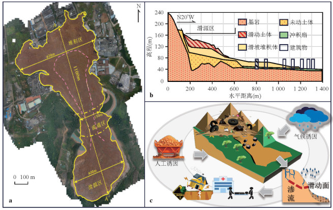
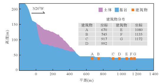
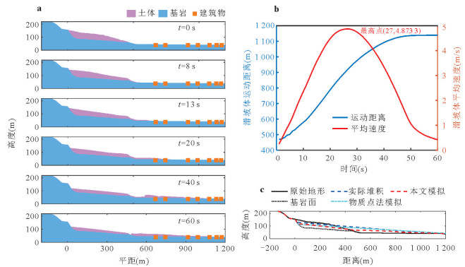
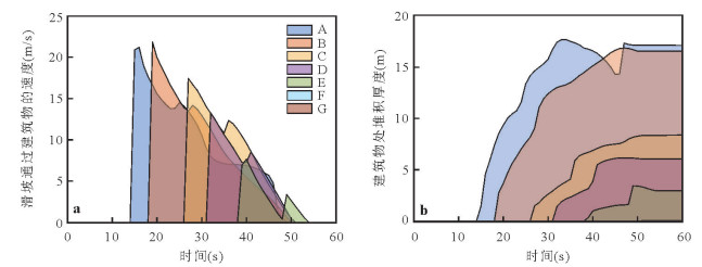
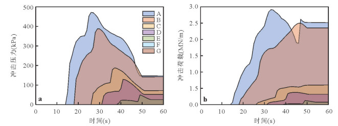
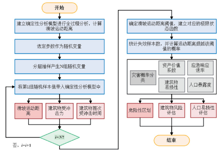
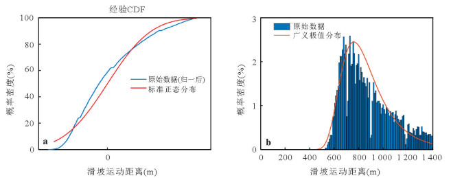
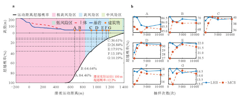
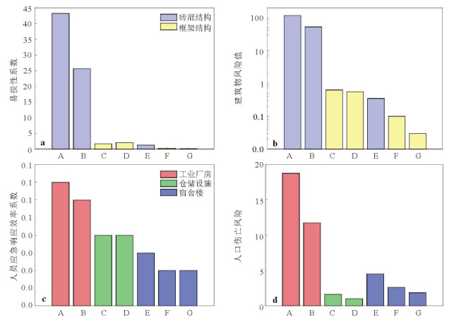
2025, 50(12): 5000-5011.
doi: 10.3799/dqkx.2025.197
Abstract:
Aiming at the impact of dewatering in metro deep foundation pits on the deformation and safe operation of adjacent high-speed railway bridge piles, this study investigates the mechanism of pile-soil interaction under seepage-stress coupling effects and proposes effective collaborative control measures. Through field pre-dewatering tests, variations in groundwater levels and surface settlement around bridge piles under different drawdown conditions were monitored. Using Abaqus for numerical simulation, a seepage-stress coupling model was established to analyze the influence of different dewatering depths on the lateral friction resistance and neutral point position of pile foundations, with comparative analysis against field data to summarize variation patterns.As the dewatering depth increases, the disturbed seepage field gradually extends toward the pile foundation, forming a seepage flow pattern around the piles. The deformation of the pile foundation exhibits nonlinear growth, with significant increases in settlement and lateral deformation observed after exceeding a 10 m drawdown. Negative skin friction in the upper part of the pile increases, the neutral point shifts downward, and positive skin friction at the pile base enhances.The deformation of bridge piles adjacent to metro deep foundation pits during dewatering is considerably influenced by the dewatering depth. Collaborative control measures such as multi-stage dewatering, waterproof curtains, real-time water level monitoring, and recharge can be adopted to mitigate pile deformation and ensure the operational safety of high-speed railways.
Aiming at the impact of dewatering in metro deep foundation pits on the deformation and safe operation of adjacent high-speed railway bridge piles, this study investigates the mechanism of pile-soil interaction under seepage-stress coupling effects and proposes effective collaborative control measures. Through field pre-dewatering tests, variations in groundwater levels and surface settlement around bridge piles under different drawdown conditions were monitored. Using Abaqus for numerical simulation, a seepage-stress coupling model was established to analyze the influence of different dewatering depths on the lateral friction resistance and neutral point position of pile foundations, with comparative analysis against field data to summarize variation patterns.As the dewatering depth increases, the disturbed seepage field gradually extends toward the pile foundation, forming a seepage flow pattern around the piles. The deformation of the pile foundation exhibits nonlinear growth, with significant increases in settlement and lateral deformation observed after exceeding a 10 m drawdown. Negative skin friction in the upper part of the pile increases, the neutral point shifts downward, and positive skin friction at the pile base enhances.The deformation of bridge piles adjacent to metro deep foundation pits during dewatering is considerably influenced by the dewatering depth. Collaborative control measures such as multi-stage dewatering, waterproof curtains, real-time water level monitoring, and recharge can be adopted to mitigate pile deformation and ensure the operational safety of high-speed railways.