2026 Vol. 51, No. 1
Display Method:
2026, 51(1): 1-13.
doi: 10.3799/dqkx.2025.253
 PDF 9409KB
Abstract:
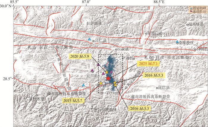
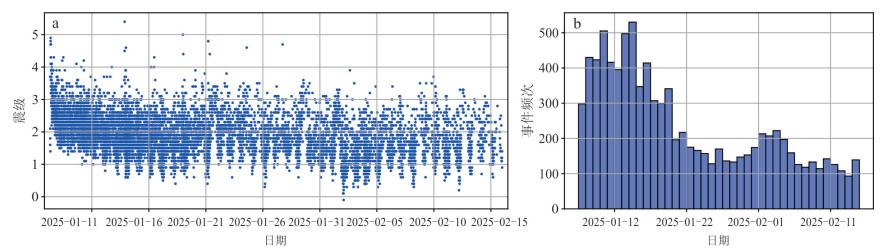
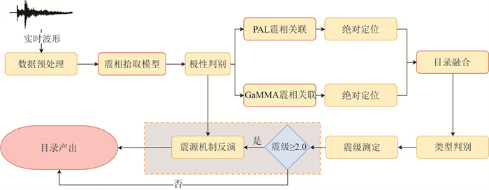
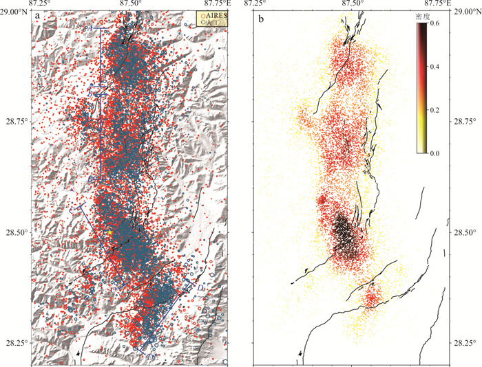
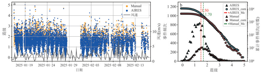
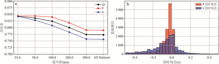
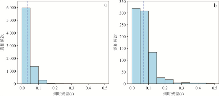
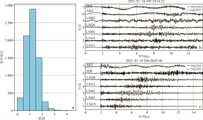
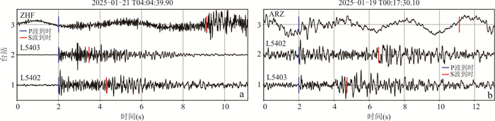
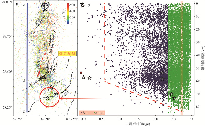
On January 7, 2025, an MW7.1 earthquake struck Dingri, Xizang, causing severe casualties. This study employs data from 12 permanent and 6 temporary seismic stations deployed around the epicentral area to process the aftershock sequence using the AIRES (Artificial Intelligence Real-time Earthquake processing System). The goal is to evaluate the performance of AIRES under a sparse seismic network configuration. AIRES, based on deep learning algorithms, automatically conducts earthquake detection, phase picking, event association, and source parameter inversion from real-time waveforms. Comparison with the manual catalog demonstrates that AIRES detected 11 242 aftershocks, which is 2.53 times the size of the manual catalog, effectively lowering the magnitude of completeness to ML1.5. The average differences between the two catalogs are 4.69 km in epicenter, 5.71 km in focal depth, and -0.02 in local magnitude. The aftershocks are distributed in a north- south-trending zone approximately 80 km long and 30 km wide, exhibiting distinct segmentation and bending features. The study demonstrates that AIRES maintains robust detection capability and location accuracy even under sparse network conditions, providing strong technical support for real-time monitoring of dense aftershock sequences and earthquake emergency response.
On January 7, 2025, an MW7.1 earthquake struck Dingri, Xizang, causing severe casualties. This study employs data from 12 permanent and 6 temporary seismic stations deployed around the epicentral area to process the aftershock sequence using the AIRES (Artificial Intelligence Real-time Earthquake processing System). The goal is to evaluate the performance of AIRES under a sparse seismic network configuration. AIRES, based on deep learning algorithms, automatically conducts earthquake detection, phase picking, event association, and source parameter inversion from real-time waveforms. Comparison with the manual catalog demonstrates that AIRES detected 11 242 aftershocks, which is 2.53 times the size of the manual catalog, effectively lowering the magnitude of completeness to ML1.5. The average differences between the two catalogs are 4.69 km in epicenter, 5.71 km in focal depth, and -0.02 in local magnitude. The aftershocks are distributed in a north- south-trending zone approximately 80 km long and 30 km wide, exhibiting distinct segmentation and bending features. The study demonstrates that AIRES maintains robust detection capability and location accuracy even under sparse network conditions, providing strong technical support for real-time monitoring of dense aftershock sequences and earthquake emergency response.
2026, 51(1): 14-29.
doi: 10.3799/dqkx.2025.078
Abstract:
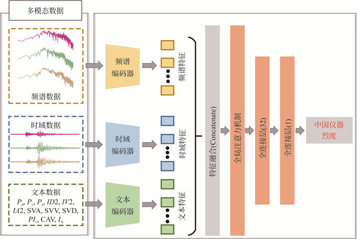
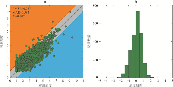
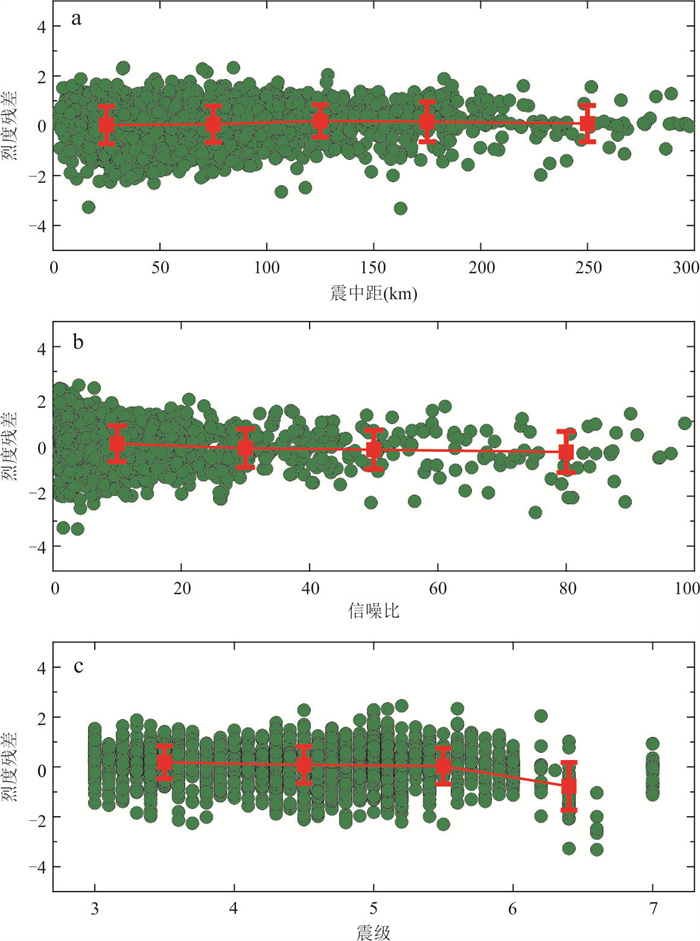
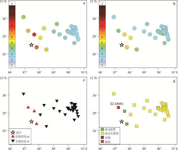
The Chinese seismic instrument intensity prediction is crucial for earthquake early warning (EEW) and hazard mitigation in China, but traditional methods suffer from issues such as insufficient accuracy and insufficient fusion of multi-source data. This study aims to construct a multimodal deep learning model, explore its feasibility for predicting seismic instrument intensity in China, and improve the accuracy and robustness of instrument intensity prediction for EEW. A Multimodal Chinese Instrument Intensity prediction Network (MCIINet) is proposed, which is trained and tested by the seismic events recorded by China Earthquake Networks Center. Experiments have shown that on the test dataset, compared to the baseline model at 3 s after P-wave triggering, MCIINet reduced MAE and RMSE of instrument intensity prediction by 9.03% and 8.67%, respectively, and improved R2 and accuracy by 9.10% and 2.51%, respectively. MCIINet has effectively improved the accuracy of intensity prediction through multimodal deep feature fusion, verifying the feasibility of multimodal deep learning for seismic instrument intensity prediction in China, and providing technical support for instrument intensity prediction in EEW.
The Chinese seismic instrument intensity prediction is crucial for earthquake early warning (EEW) and hazard mitigation in China, but traditional methods suffer from issues such as insufficient accuracy and insufficient fusion of multi-source data. This study aims to construct a multimodal deep learning model, explore its feasibility for predicting seismic instrument intensity in China, and improve the accuracy and robustness of instrument intensity prediction for EEW. A Multimodal Chinese Instrument Intensity prediction Network (MCIINet) is proposed, which is trained and tested by the seismic events recorded by China Earthquake Networks Center. Experiments have shown that on the test dataset, compared to the baseline model at 3 s after P-wave triggering, MCIINet reduced MAE and RMSE of instrument intensity prediction by 9.03% and 8.67%, respectively, and improved R2 and accuracy by 9.10% and 2.51%, respectively. MCIINet has effectively improved the accuracy of intensity prediction through multimodal deep feature fusion, verifying the feasibility of multimodal deep learning for seismic instrument intensity prediction in China, and providing technical support for instrument intensity prediction in EEW.
2026, 51(1): 30-42.
doi: 10.3799/dqkx.2025.085
Abstract:
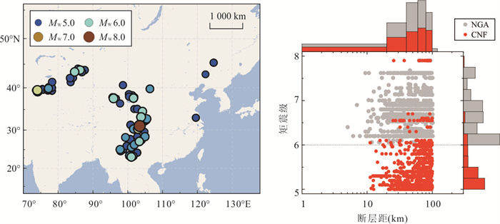
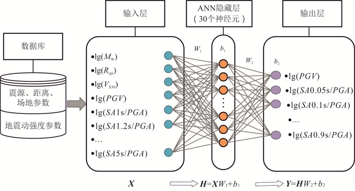
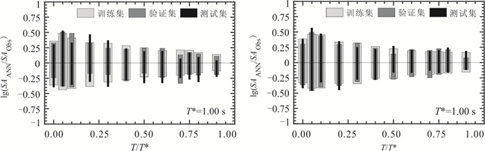
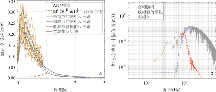
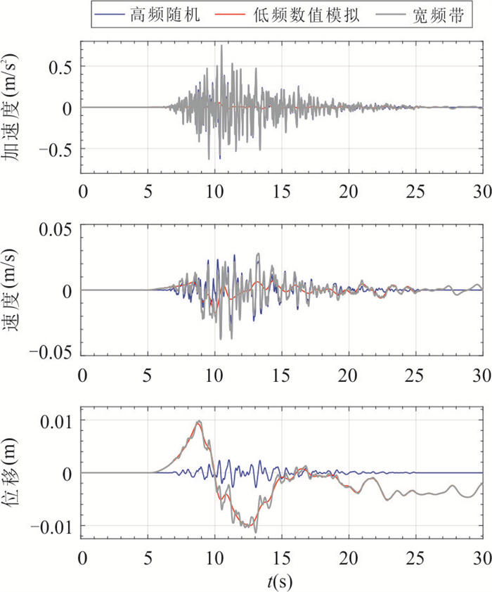
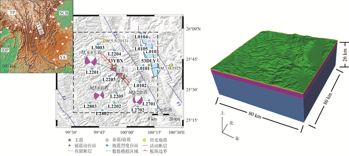
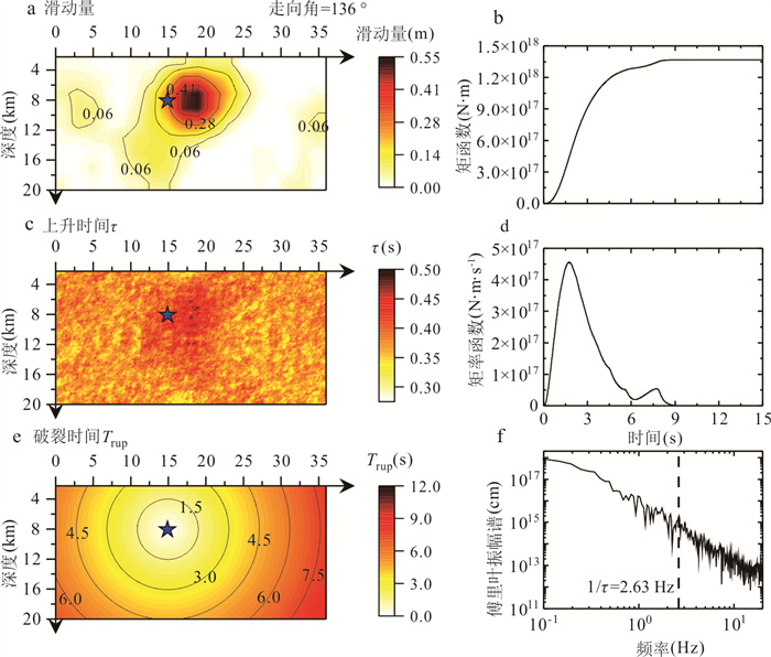
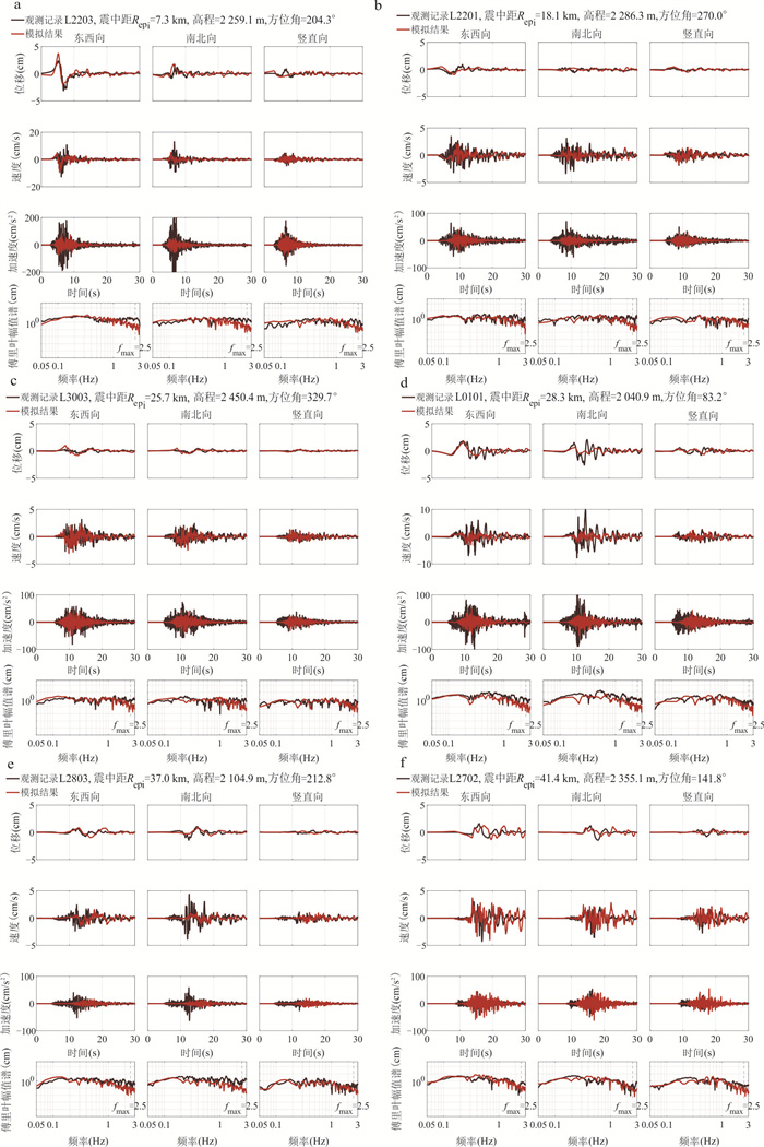
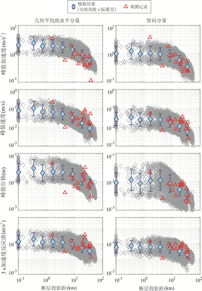
Broadband ground motion simulation is a critical issue in engineering seismology. As traditional methods often face issues of spectral mismatch and energy phase conflicts when combining low-frequency physics-based modeling with high-frequency stochastic components, this paper introduces a hybrid method that integrates artificial neural network (ANN) with spectral element method (SEM). The ANN is trained on the Strong Motion Flatfile of China to capture the nonlinear mapping of short-period response spectra, while the SEM is employed to simulate low-frequency ground motions. High-frequency stochastic components are optimized using scaling factors, and energy alignment is applied to synchronize low- and high-frequency time histories, ensuring stable broadband simulation results. Taking the Yangbi MS6.4 earthquake as a case study, a finite fault model derived from inversion and a refined 3D velocity structure model are used to generate low-frequency time histories for monitors. The broadband method is then applied to produce corresponding broadband simulation time histories. The results demonstrate that the simulated broadband acceleration time histories exhibit strong consistency with observed records, providing reliable and realistic inputs for seismic hazard analysis.
Broadband ground motion simulation is a critical issue in engineering seismology. As traditional methods often face issues of spectral mismatch and energy phase conflicts when combining low-frequency physics-based modeling with high-frequency stochastic components, this paper introduces a hybrid method that integrates artificial neural network (ANN) with spectral element method (SEM). The ANN is trained on the Strong Motion Flatfile of China to capture the nonlinear mapping of short-period response spectra, while the SEM is employed to simulate low-frequency ground motions. High-frequency stochastic components are optimized using scaling factors, and energy alignment is applied to synchronize low- and high-frequency time histories, ensuring stable broadband simulation results. Taking the Yangbi MS6.4 earthquake as a case study, a finite fault model derived from inversion and a refined 3D velocity structure model are used to generate low-frequency time histories for monitors. The broadband method is then applied to produce corresponding broadband simulation time histories. The results demonstrate that the simulated broadband acceleration time histories exhibit strong consistency with observed records, providing reliable and realistic inputs for seismic hazard analysis.
2026, 51(1): 43-55.
doi: 10.3799/dqkx.2025.186
Abstract:
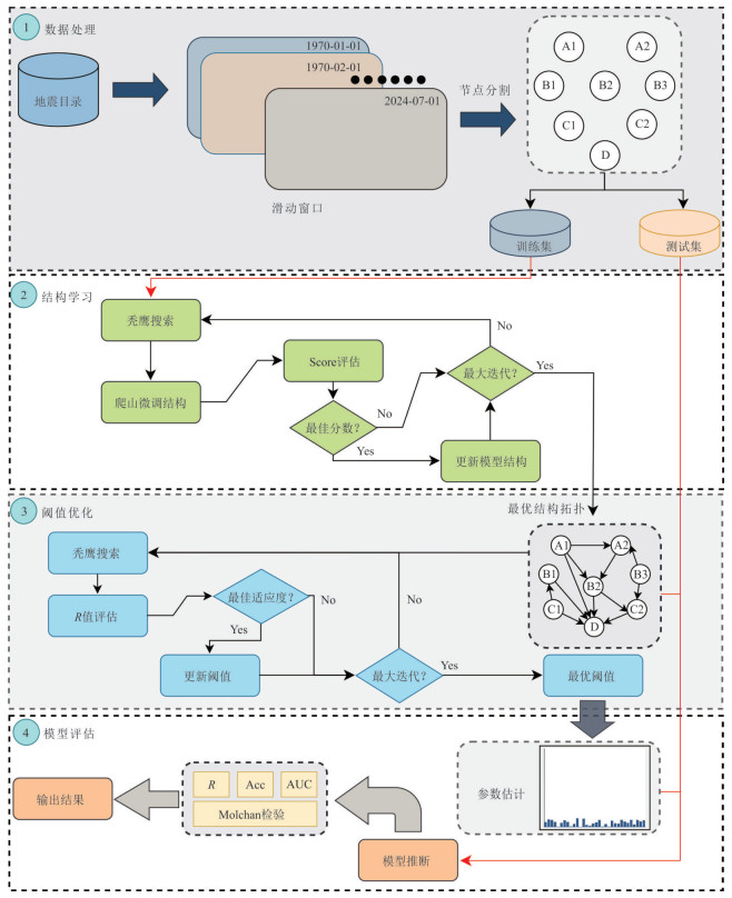
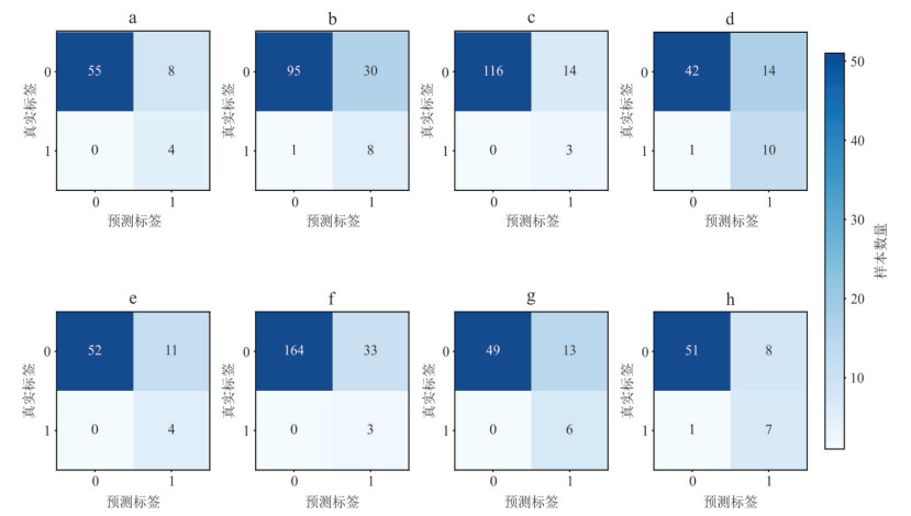
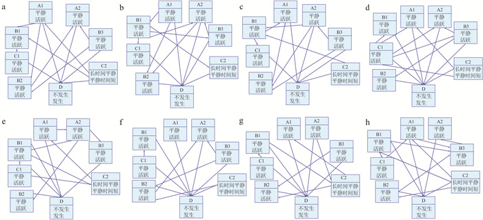
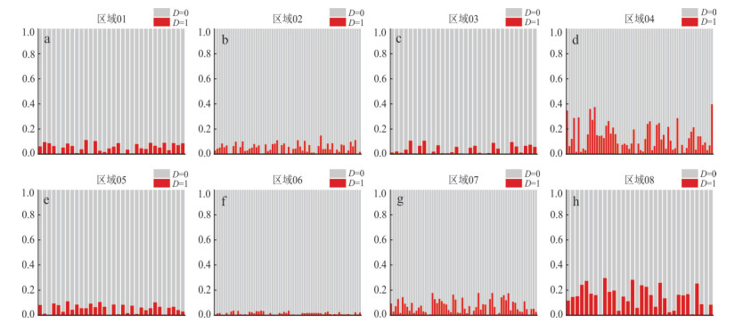
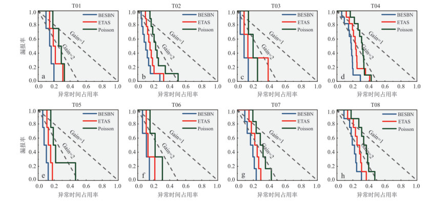
To enhance the capability for monthly-scale regional strong earthquake risk prediction, this paper introduces a probabilistic seismic hazard prediction model based on Bayesian network structure learning. Initially, a series of predictive indicators, serving as the nodes of the Bayesian network, are derived from the earthquake catalog. Subsequently, the thresholds for each node and the directed connections among nodes are determined using swarm intelligence algorithms. Ultimately, through parameter estimation, the target node outputs the probability of MW5.0+ strong earthquakes occurring in the target region within the next month. Experimental results indicate that the model achieves an average prediction efficiency metric of 0.783, and validation via the Molchan test confirms its significant effectiveness, demonstrating the model's capacity to comprehensively explore the latent causal relationships between seismic precursors and strong earthquakes.
To enhance the capability for monthly-scale regional strong earthquake risk prediction, this paper introduces a probabilistic seismic hazard prediction model based on Bayesian network structure learning. Initially, a series of predictive indicators, serving as the nodes of the Bayesian network, are derived from the earthquake catalog. Subsequently, the thresholds for each node and the directed connections among nodes are determined using swarm intelligence algorithms. Ultimately, through parameter estimation, the target node outputs the probability of MW5.0+ strong earthquakes occurring in the target region within the next month. Experimental results indicate that the model achieves an average prediction efficiency metric of 0.783, and validation via the Molchan test confirms its significant effectiveness, demonstrating the model's capacity to comprehensively explore the latent causal relationships between seismic precursors and strong earthquakes.
2026, 51(1): 56-73.
doi: 10.3799/dqkx.2025.252
Abstract:
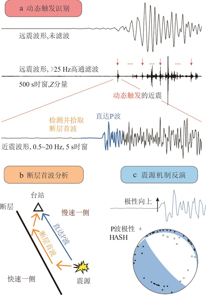
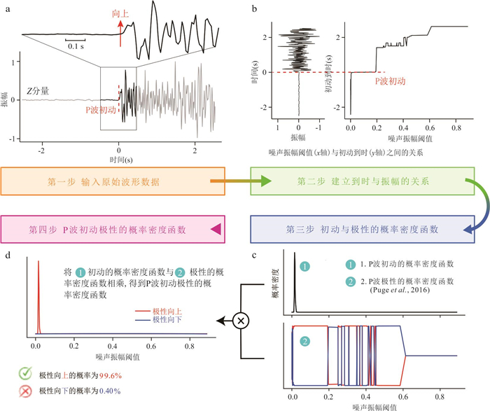
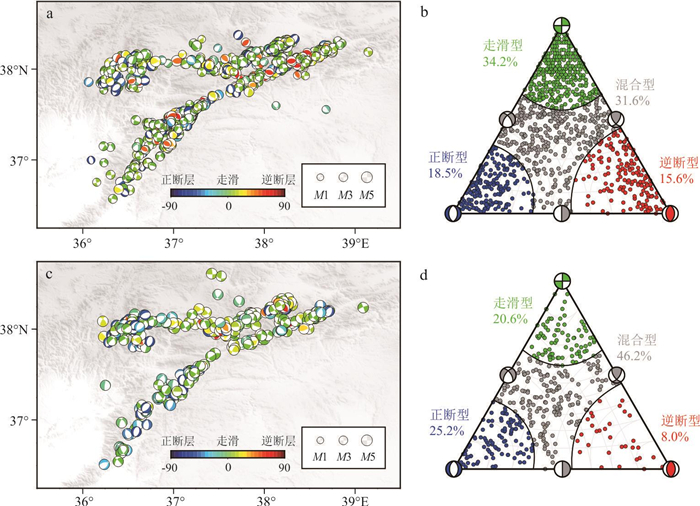
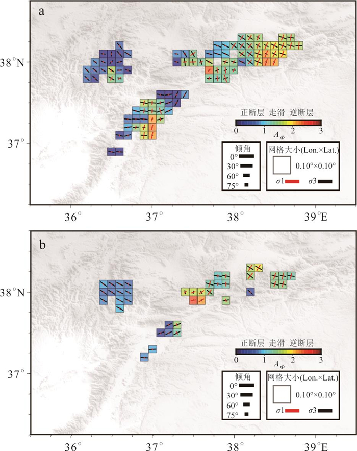
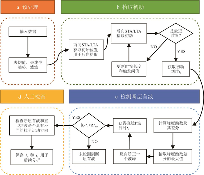
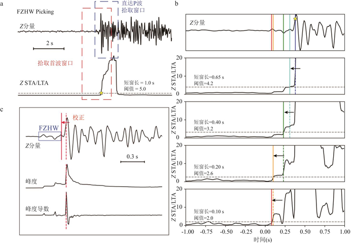
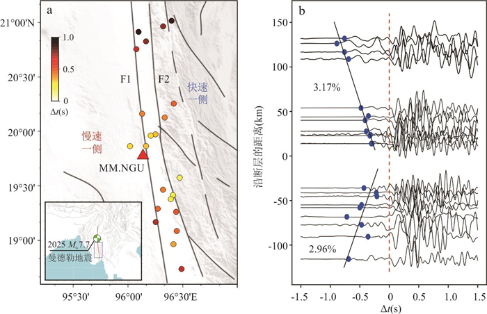
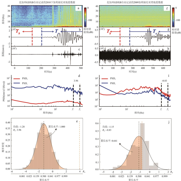
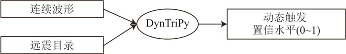
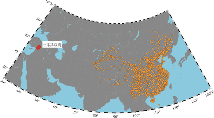
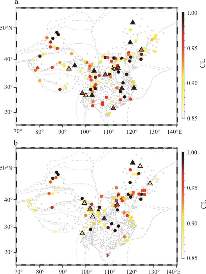
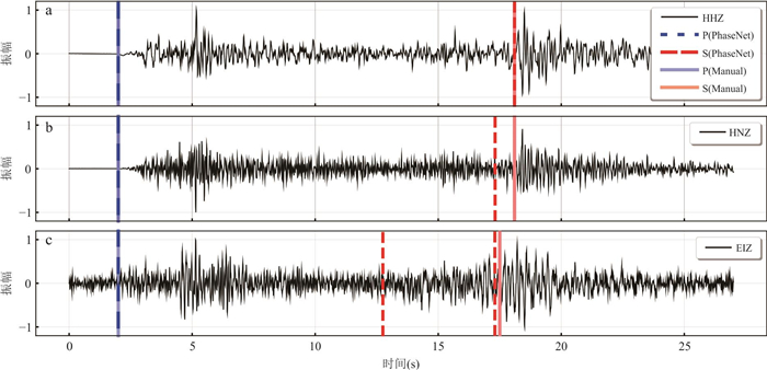
In recent years, the rapid accumulation of massive digital seismic observations has created an urgent demand for efficient and intelligent data-processing methods. This paper presents a suite of new intelligent approaches to seismic data processing developed by our research group, including: POSE, an automatic P-wave first-motion polarity determination method based on Order Statistics and Entropy theory; an automatic detection algorithm for fault zone head waves designed to identify bimaterial interfaces; and HiFi, a method for detecting remote dynamic triggering based on the High-Frequency Power Integral Ratio. These methods not only significantly enhance the resolution of focal mechanism solutions and stress field inversions for small earthquakes, but also provide new tools for characterizing medium contrasts across faults and for investigating how dynamic stress perturbations modulate small earthquake activity. Through application to the 2023 Turkey earthquake doublet and the 2025 Mw 7.7 Mandalay, Myanmar earthquake, we demonstrate the advantages of POSE in focal mechanism determination and regional stress field inversion, the effectiveness of fault zone head-wave detection in revealing velocity contrasts across bimaterial fault interfaces, and the robustness of the HiFi method in identifying long-range dynamic triggering associated with large earthquakes. These new observations offer important support for fault-zone structural imaging, rupture dynamics studies, and seismic hazard assessment, and highlight the broad prospects of intelligent techniques in seismological research.
In recent years, the rapid accumulation of massive digital seismic observations has created an urgent demand for efficient and intelligent data-processing methods. This paper presents a suite of new intelligent approaches to seismic data processing developed by our research group, including: POSE, an automatic P-wave first-motion polarity determination method based on Order Statistics and Entropy theory; an automatic detection algorithm for fault zone head waves designed to identify bimaterial interfaces; and HiFi, a method for detecting remote dynamic triggering based on the High-Frequency Power Integral Ratio. These methods not only significantly enhance the resolution of focal mechanism solutions and stress field inversions for small earthquakes, but also provide new tools for characterizing medium contrasts across faults and for investigating how dynamic stress perturbations modulate small earthquake activity. Through application to the 2023 Turkey earthquake doublet and the 2025 Mw 7.7 Mandalay, Myanmar earthquake, we demonstrate the advantages of POSE in focal mechanism determination and regional stress field inversion, the effectiveness of fault zone head-wave detection in revealing velocity contrasts across bimaterial fault interfaces, and the robustness of the HiFi method in identifying long-range dynamic triggering associated with large earthquakes. These new observations offer important support for fault-zone structural imaging, rupture dynamics studies, and seismic hazard assessment, and highlight the broad prospects of intelligent techniques in seismological research.
2026, 51(1): 74-89.
doi: 10.3799/dqkx.2025.287
Abstract:
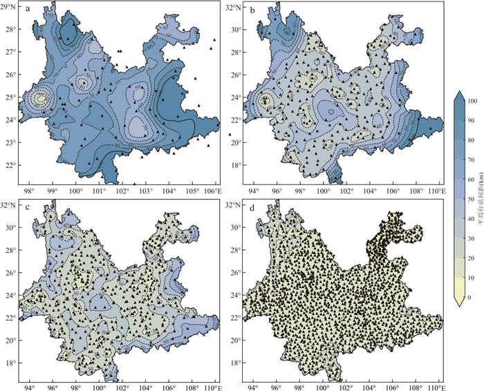
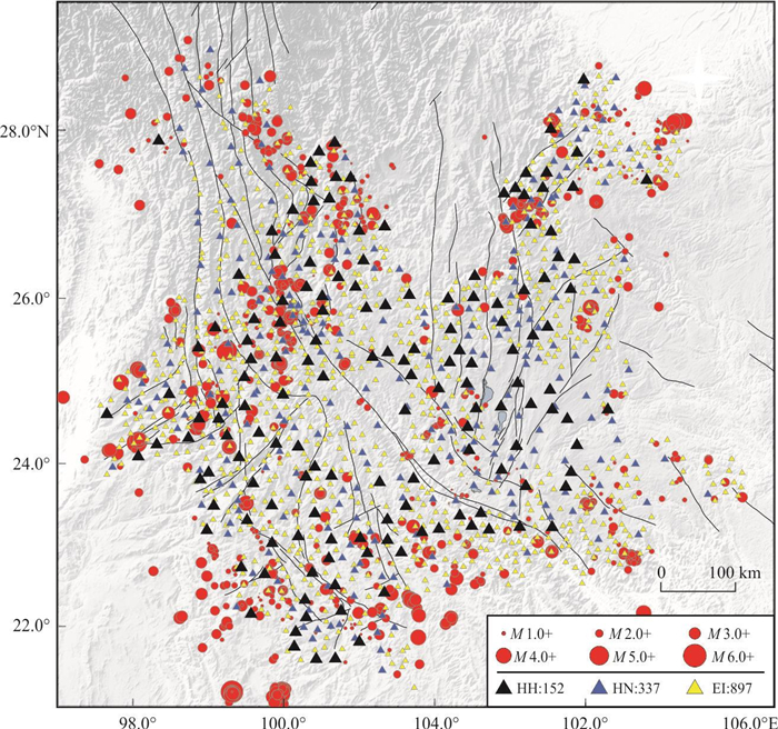
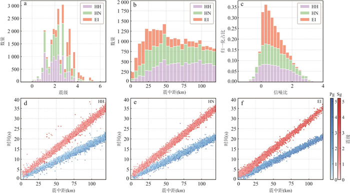
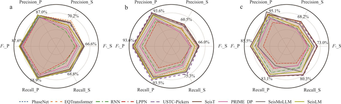
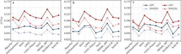
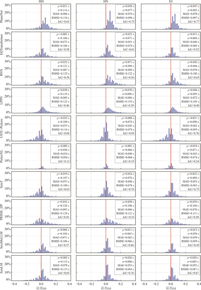
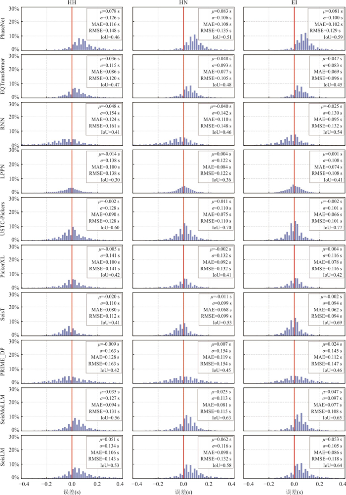
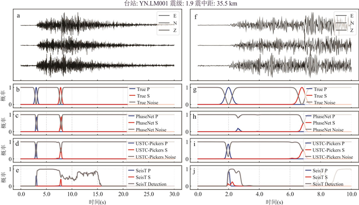
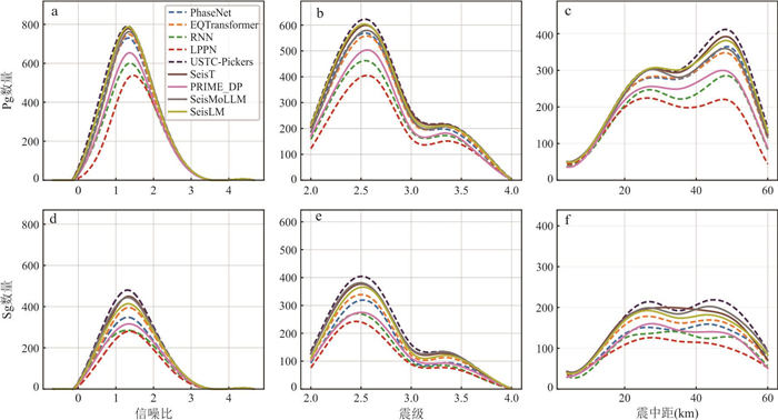
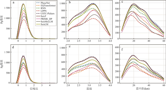
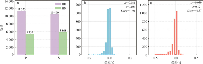
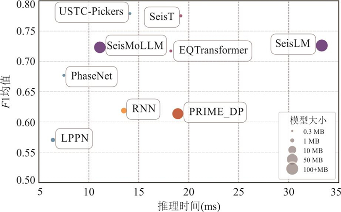
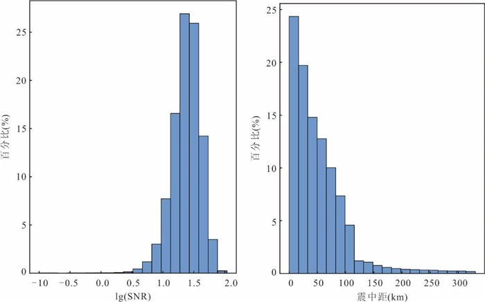
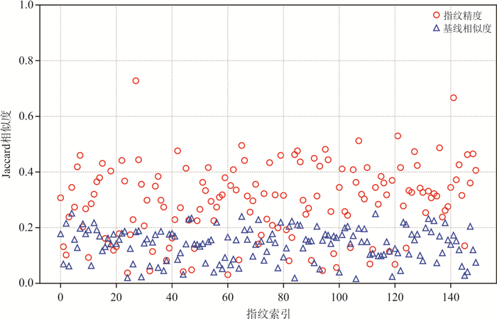
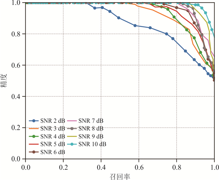
In recent years, deep learning methods have been widely applied to seismic detection and phase picking. However, existing models are mainly trained on high signal-to-noise ratio (SNR) velocity-type waveform data, with limited evaluation of their generalization to accelerometer and intensity meter data. To investigate the performance of existing models on accelerometer data and their generalization capability in Yunnan, this study constructed a high-quality, multi-source heterogeneous waveform dataset based on the latest observations from the Yunnan Earthquake Early Warning (EEW) network, including velocity meters, accelerometers, and intensity meters, with all phase arrival times manually annotated. It systematically evaluated the phase-picking performance of nine models-on the Yunnan dataset five domain-specific models (e.g., PhaseNet, USTC-Pickers) and four large models (e.g., SeisMoLLM, SeisT). The locally fine-tuned USTC-Pickers achieved the best overall performance, with mean F1 scores of 0.779 for Pg and Sg phase picking (Δt≤0.1 s), significantly outperforming other models, and effectively mitigating phase-picking delays for accelerometer and intensity meter data. Large models demonstrated stronger generalization in Sg picking and low-SNR conditions. The study also revealed performance variations of mainstream seismic detection models under different waveform lengths, magnitudes, and epicentral distances, underscoring the importance of localized training and model architecture selection in practical applications. The research findings provide references for seismic detection and phase picking in earthquake early warning systems, as well as for the real-time automatic processing of seismic data at the China Earthquake Science Experiment Site.
In recent years, deep learning methods have been widely applied to seismic detection and phase picking. However, existing models are mainly trained on high signal-to-noise ratio (SNR) velocity-type waveform data, with limited evaluation of their generalization to accelerometer and intensity meter data. To investigate the performance of existing models on accelerometer data and their generalization capability in Yunnan, this study constructed a high-quality, multi-source heterogeneous waveform dataset based on the latest observations from the Yunnan Earthquake Early Warning (EEW) network, including velocity meters, accelerometers, and intensity meters, with all phase arrival times manually annotated. It systematically evaluated the phase-picking performance of nine models-on the Yunnan dataset five domain-specific models (e.g., PhaseNet, USTC-Pickers) and four large models (e.g., SeisMoLLM, SeisT). The locally fine-tuned USTC-Pickers achieved the best overall performance, with mean F1 scores of 0.779 for Pg and Sg phase picking (Δt≤0.1 s), significantly outperforming other models, and effectively mitigating phase-picking delays for accelerometer and intensity meter data. Large models demonstrated stronger generalization in Sg picking and low-SNR conditions. The study also revealed performance variations of mainstream seismic detection models under different waveform lengths, magnitudes, and epicentral distances, underscoring the importance of localized training and model architecture selection in practical applications. The research findings provide references for seismic detection and phase picking in earthquake early warning systems, as well as for the real-time automatic processing of seismic data at the China Earthquake Science Experiment Site.

2026, 51(1): 90-103.
doi: 10.3799/dqkx.2025.184
Abstract:
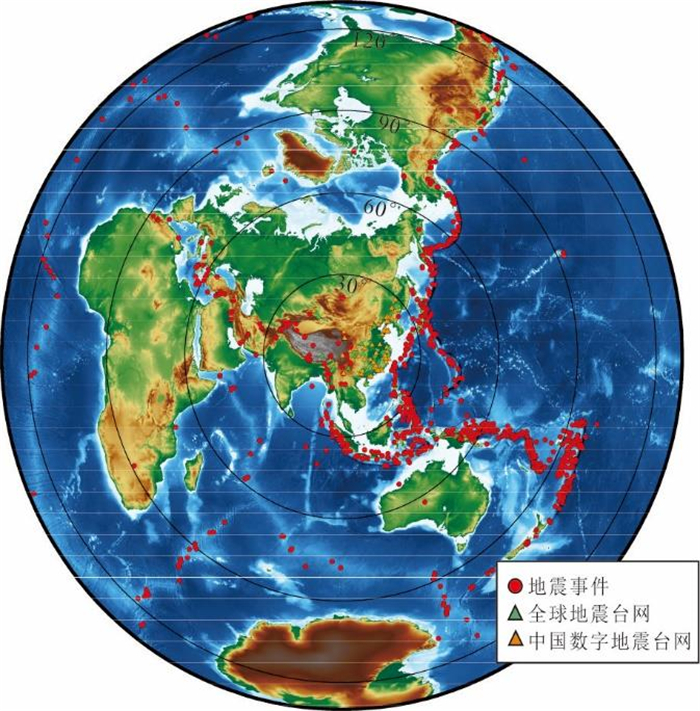
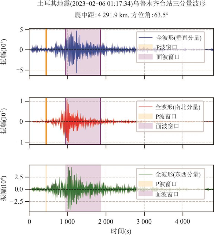
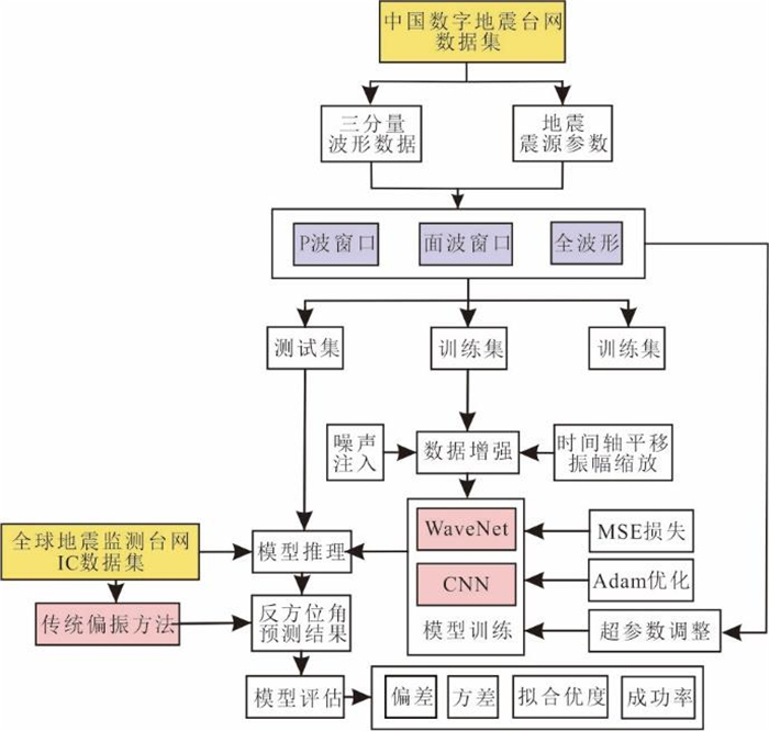
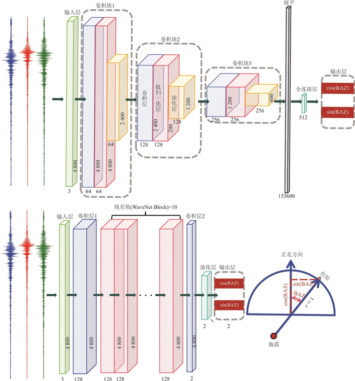
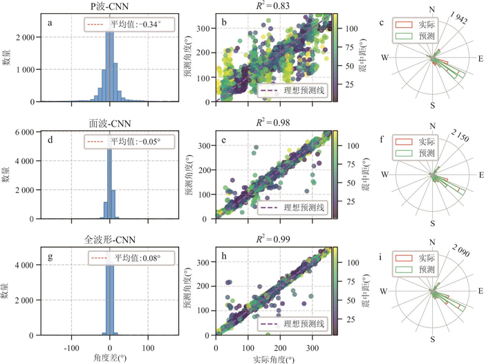
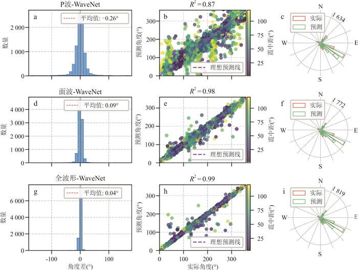
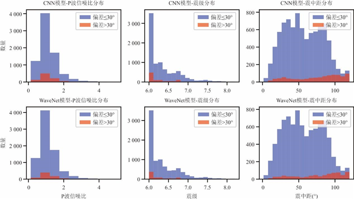
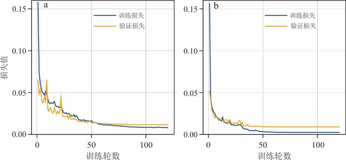
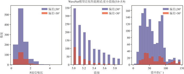
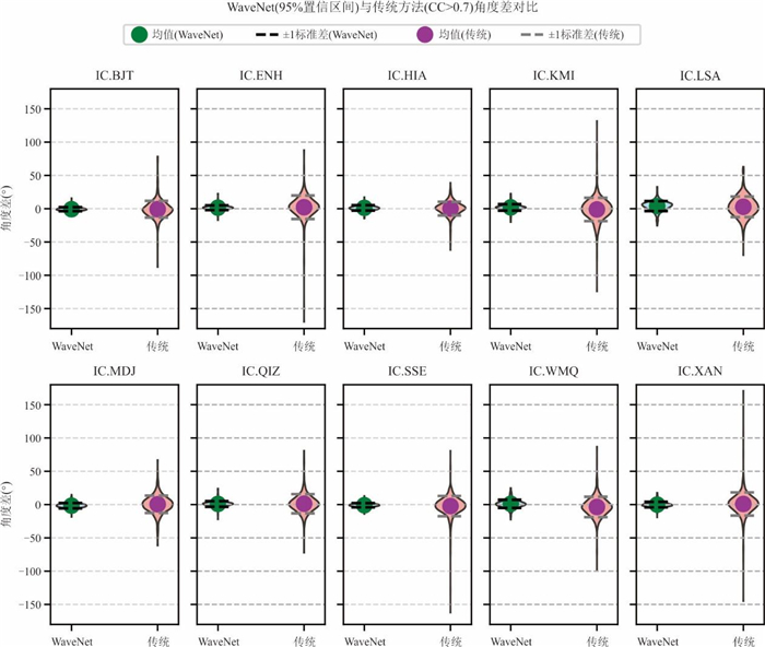
Earthquake location is fundamental to both early warning systems and studies of the Earth's deep structure, yet its accuracy remains challenging to be improved. Using three-component waveform data from the China National Seismic Network, this study develops a single-station back-azimuth estimation method based on deep learning. We compare the performance of a standard convolutional neural network with that of a WaveNet architecture under three input settings: P-wave only, surface-wave only, and full-waveform input. Results show that WaveNet combined with full-waveform input performs best, benefiting from dilated convolutions and residual connections that enhance its ability to extract long-range temporal features. The model achieves an average back-azimuth deviation of only 0.04°, with a coefficient of determination (R2) of 0.99. Independent tests demonstrate strong generalization capability, with the mean absolute deviation and variance reduced by 58.70% and 28.21%, respectively, compared with the traditional surface-wave polarization method. The findings indicate that deep learning with full-waveform input can substantially improve single-station location accuracy, offering effective technical support for earthquake early warning and seismic monitoring in challenging environments.
Earthquake location is fundamental to both early warning systems and studies of the Earth's deep structure, yet its accuracy remains challenging to be improved. Using three-component waveform data from the China National Seismic Network, this study develops a single-station back-azimuth estimation method based on deep learning. We compare the performance of a standard convolutional neural network with that of a WaveNet architecture under three input settings: P-wave only, surface-wave only, and full-waveform input. Results show that WaveNet combined with full-waveform input performs best, benefiting from dilated convolutions and residual connections that enhance its ability to extract long-range temporal features. The model achieves an average back-azimuth deviation of only 0.04°, with a coefficient of determination (R2) of 0.99. Independent tests demonstrate strong generalization capability, with the mean absolute deviation and variance reduced by 58.70% and 28.21%, respectively, compared with the traditional surface-wave polarization method. The findings indicate that deep learning with full-waveform input can substantially improve single-station location accuracy, offering effective technical support for earthquake early warning and seismic monitoring in challenging environments.
2026, 51(1): 104-115.
doi: 10.3799/dqkx.2025.086
Abstract:
Seismic phase picking is a critical task in earthquake monitoring, as its accuracy directly impacts the precision of hypocenter localization and magnitude estimation. However, traditional methods are often limited in their ability to capture the characteristics of complex seismic signals. This study proposes a dual-branch deep learning model that integrates a multi-scale attention mechanism and short-time Fourier transform (STFT). The model extracts temporal features through a time-domain branch and captures time-frequency representations via a frequency-domain branch, while leveraging the attention mechanism to enhance multi-scale features. Experimental results show that within a 100 ms error threshold, the proposed model achieves a P-wave picking precision and recall of 95.69% and 88.97%, and an S-wave precision and recall of 87.98% and 77.25%, respectively. The mean and standard deviation of arrival time error for the P-wave are 18.76 ms and 27.13 ms, while for the S-wave they are 25.97 ms and 36.14 ms. Moreover, the model contains only 0.35 M parameters and incurs a computational cost of 71.38 M FLOPs. Compared with existing models, the SEN model not only achieves competitive performance but also demonstrates advantages in model size and computational efficiency, offering great potential for real-time seismic monitoring applications.
Seismic phase picking is a critical task in earthquake monitoring, as its accuracy directly impacts the precision of hypocenter localization and magnitude estimation. However, traditional methods are often limited in their ability to capture the characteristics of complex seismic signals. This study proposes a dual-branch deep learning model that integrates a multi-scale attention mechanism and short-time Fourier transform (STFT). The model extracts temporal features through a time-domain branch and captures time-frequency representations via a frequency-domain branch, while leveraging the attention mechanism to enhance multi-scale features. Experimental results show that within a 100 ms error threshold, the proposed model achieves a P-wave picking precision and recall of 95.69% and 88.97%, and an S-wave precision and recall of 87.98% and 77.25%, respectively. The mean and standard deviation of arrival time error for the P-wave are 18.76 ms and 27.13 ms, while for the S-wave they are 25.97 ms and 36.14 ms. Moreover, the model contains only 0.35 M parameters and incurs a computational cost of 71.38 M FLOPs. Compared with existing models, the SEN model not only achieves competitive performance but also demonstrates advantages in model size and computational efficiency, offering great potential for real-time seismic monitoring applications.
2026, 51(1): 116-129.
doi: 10.3799/dqkx.2025.281
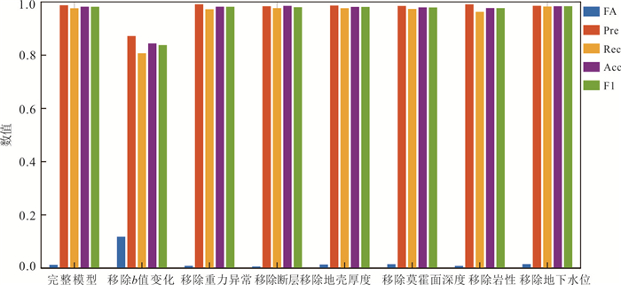
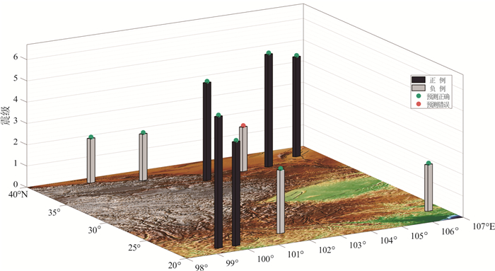
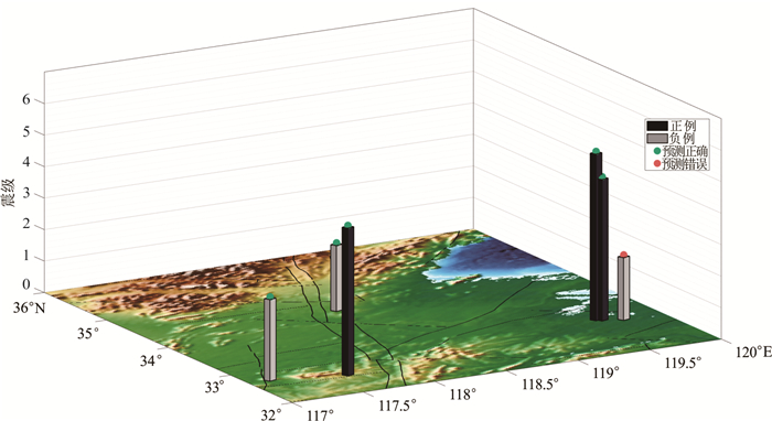
Abstract:
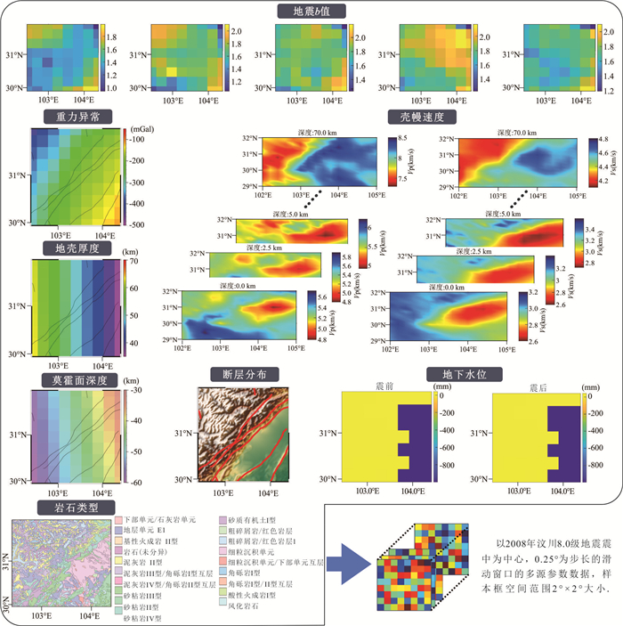
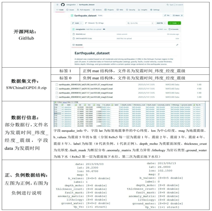
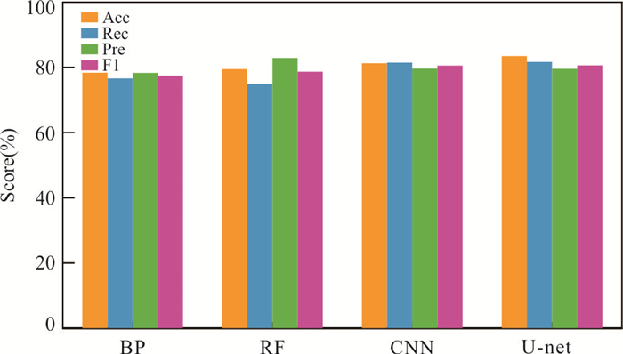
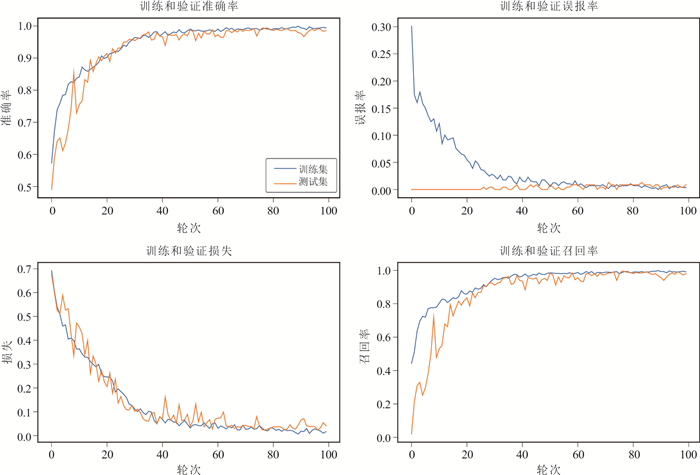
The Sichuan-Yunnan region is characterized by intense neotectonic movements and seismic activities. Over the past two decades, a large amount of geophysical observation data have been accumulated. Among them, earthquakes with magnitudes ≥4.5 are particularly concerned due to the significant damage they cause. Deep learning technology, based on the principle of data-driven, can mine the implicit features among data, such as the correlation between geophysical parameter characteristics and their variations and the occurrence of moderate to strong earthquakes. However, while seismic event-based single-sample seismic wave detection datasets are abundant, geophysical background datasets are currently relatively scarce.Based on this, in this article it uses the dataset of 798 earthquakes with magnitudes ≥4.5 that occurred in the Sichuan-Yunnan region over the past 20 years. Historical earthquake catalogs, gravity, faults, crustal velocity, crustal thickness, Moho depth, lithology, and groundwater with strong correlation to earthquake occurrence within a certain spatial range centered on the earthquake source were collected. Through data processing methods such as calculation, cleaning, and normalization, an annotated dataset was created. In order to ensure the balance of positive and negative samples, it also selected geophysical data from the same region with an equal number of non-significant earthquakes (magnitude 3 and below, which have a significant energy difference from earthquakes above magnitude 4.5) as positive examples, and created a labeled negative example dataset. Examples, negative examples, and data composition were elaborated based on accuracy. The evaluation indicators such as recall rate were used to analyze the performance of the dataset in four classic learning models, all of which achieved an accuracy of about 80%. Finally, the quality of the dataset was verified through transfer learning in other regions, which was not lower than the accuracy of the dataset testset. These indicate that the constructed dataset has good quality, applicability, and generalization. This article can provide reference for the construction of other deep learning seismology datasets.
The Sichuan-Yunnan region is characterized by intense neotectonic movements and seismic activities. Over the past two decades, a large amount of geophysical observation data have been accumulated. Among them, earthquakes with magnitudes ≥4.5 are particularly concerned due to the significant damage they cause. Deep learning technology, based on the principle of data-driven, can mine the implicit features among data, such as the correlation between geophysical parameter characteristics and their variations and the occurrence of moderate to strong earthquakes. However, while seismic event-based single-sample seismic wave detection datasets are abundant, geophysical background datasets are currently relatively scarce.Based on this, in this article it uses the dataset of 798 earthquakes with magnitudes ≥4.5 that occurred in the Sichuan-Yunnan region over the past 20 years. Historical earthquake catalogs, gravity, faults, crustal velocity, crustal thickness, Moho depth, lithology, and groundwater with strong correlation to earthquake occurrence within a certain spatial range centered on the earthquake source were collected. Through data processing methods such as calculation, cleaning, and normalization, an annotated dataset was created. In order to ensure the balance of positive and negative samples, it also selected geophysical data from the same region with an equal number of non-significant earthquakes (magnitude 3 and below, which have a significant energy difference from earthquakes above magnitude 4.5) as positive examples, and created a labeled negative example dataset. Examples, negative examples, and data composition were elaborated based on accuracy. The evaluation indicators such as recall rate were used to analyze the performance of the dataset in four classic learning models, all of which achieved an accuracy of about 80%. Finally, the quality of the dataset was verified through transfer learning in other regions, which was not lower than the accuracy of the dataset testset. These indicate that the constructed dataset has good quality, applicability, and generalization. This article can provide reference for the construction of other deep learning seismology datasets.
2026, 51(1): 130-145.
doi: 10.3799/dqkx.2025.234
Abstract:
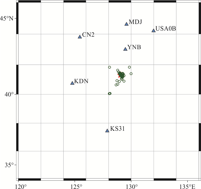
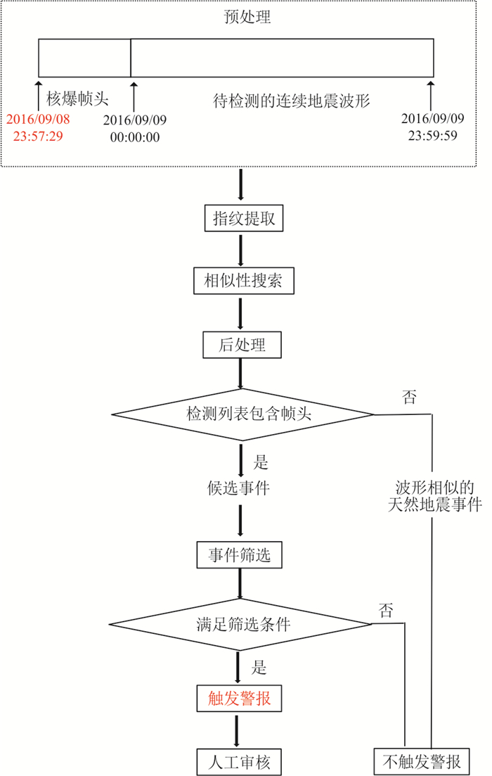
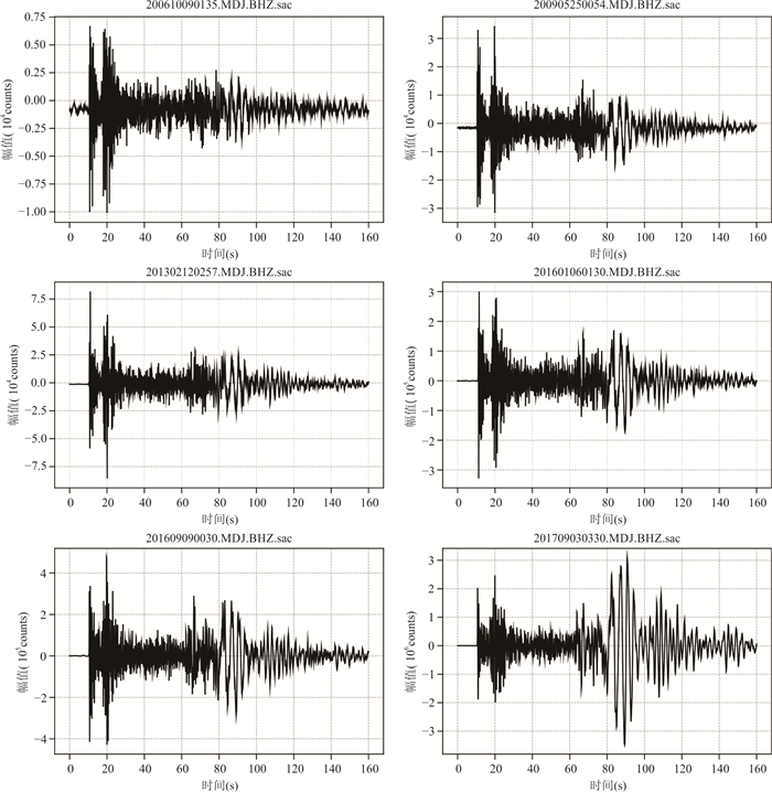
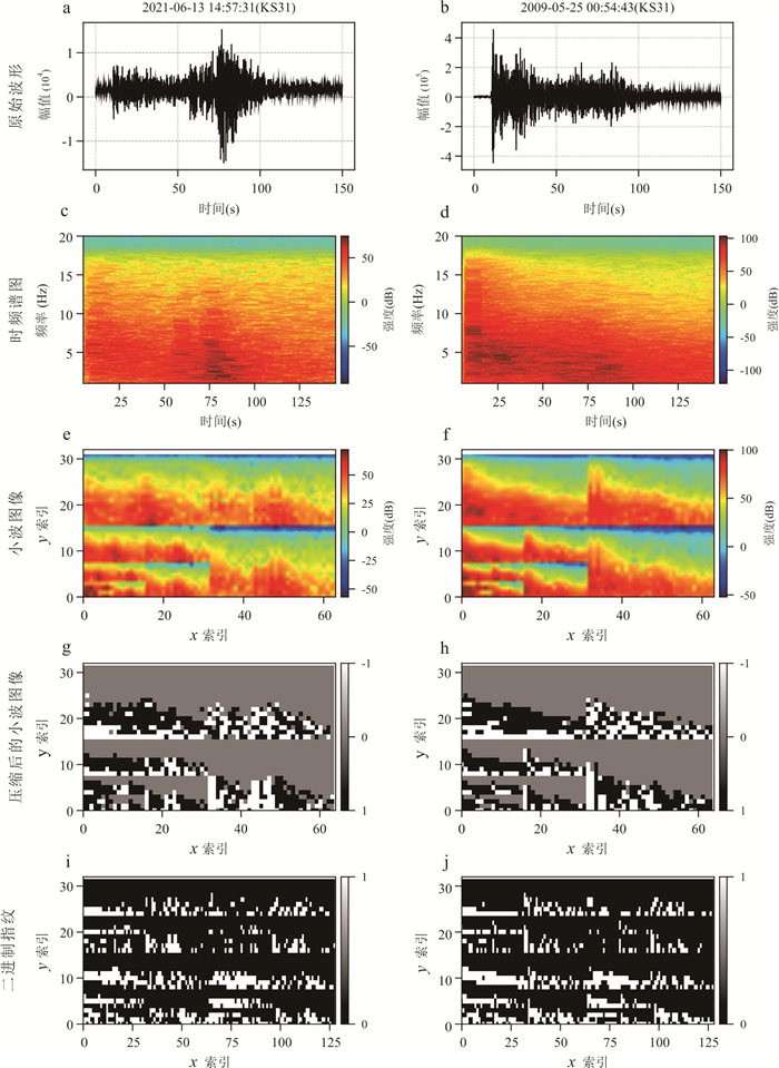
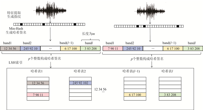
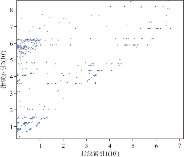
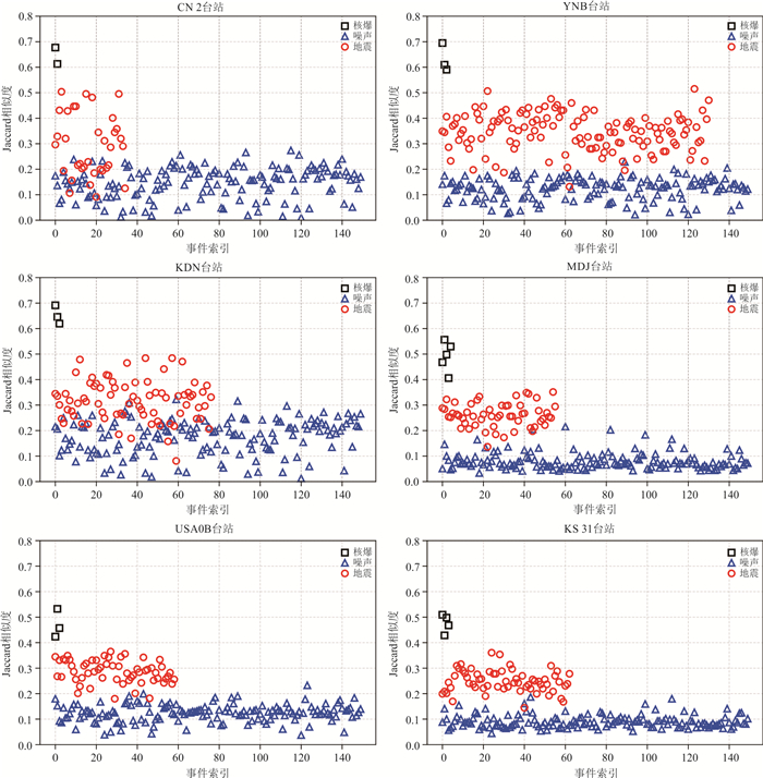
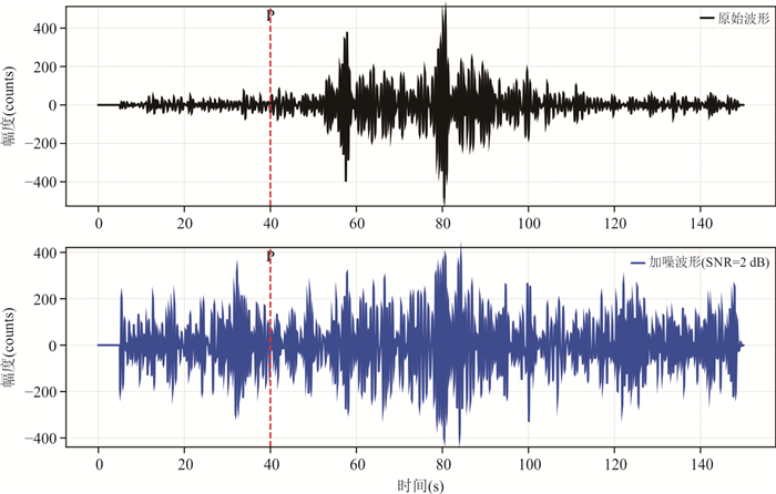
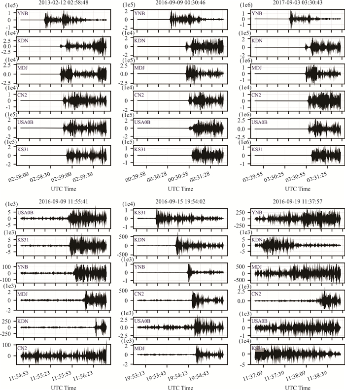
Nuclear explosion monitoring is a critical technology for nuclear test ban verification. In order to monitor potential nuclear tests worldwide, the Comprehensive Nuclear-Test-Ban Treaty (CTBT) establishes a rigorous verification regime. Within this framework, waveform data from the International Monitoring System (IMS) are transmitted in real time to the International Data Centre (IDC) for processing and analyzing. The IDC delivers automated processing results at three stages: approximately 1 h, 4 h and 6 h after data acquisition. For region-specific nuclear explosion monitoring, direct reliance on IDC results faces challenges of delayed response and high false detection rates. To address these limitations, we propose Seisprint, a rapid detection method based on seismic waveform fingerprints. Inspired by audio fingerprinting techniques, Seisprint utilizes historical nuclear explosion waveforms as templates. Continuous seismic waveforms are compressed into multiple binary fingerprints through sliding-window feature extraction. Automated nuclear event detection and real-time alerts are achieved via rapid similarity matching and clustering. The method was tested using data from two IMS seismic stations near North Korea and four seismic stations in Northeast China, covering six historical underground nuclear tests and natural seismic events in North Korea. The fingerprints generated by Seisprint effectively distinguish nuclear explosions from non-nuclear signals and demonstrate strong robustness against noise. The method processes an entire day of continuous data from multiple seismic stations within just a few minutes, enabling rapid detection of underground nuclear explosion events. Results confirm that Seisprint promote the timeliness and accuracy of underground nuclear explosion detection in specific area.
Nuclear explosion monitoring is a critical technology for nuclear test ban verification. In order to monitor potential nuclear tests worldwide, the Comprehensive Nuclear-Test-Ban Treaty (CTBT) establishes a rigorous verification regime. Within this framework, waveform data from the International Monitoring System (IMS) are transmitted in real time to the International Data Centre (IDC) for processing and analyzing. The IDC delivers automated processing results at three stages: approximately 1 h, 4 h and 6 h after data acquisition. For region-specific nuclear explosion monitoring, direct reliance on IDC results faces challenges of delayed response and high false detection rates. To address these limitations, we propose Seisprint, a rapid detection method based on seismic waveform fingerprints. Inspired by audio fingerprinting techniques, Seisprint utilizes historical nuclear explosion waveforms as templates. Continuous seismic waveforms are compressed into multiple binary fingerprints through sliding-window feature extraction. Automated nuclear event detection and real-time alerts are achieved via rapid similarity matching and clustering. The method was tested using data from two IMS seismic stations near North Korea and four seismic stations in Northeast China, covering six historical underground nuclear tests and natural seismic events in North Korea. The fingerprints generated by Seisprint effectively distinguish nuclear explosions from non-nuclear signals and demonstrate strong robustness against noise. The method processes an entire day of continuous data from multiple seismic stations within just a few minutes, enabling rapid detection of underground nuclear explosion events. Results confirm that Seisprint promote the timeliness and accuracy of underground nuclear explosion detection in specific area.
2026, 51(1): 146-159.
doi: 10.3799/dqkx.2025.105
Abstract:
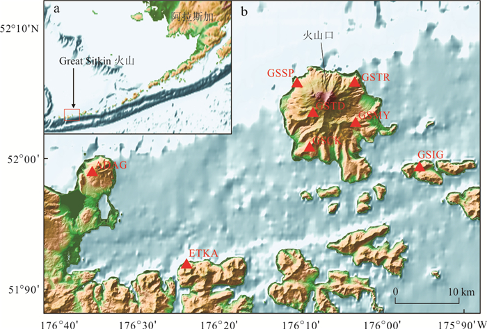
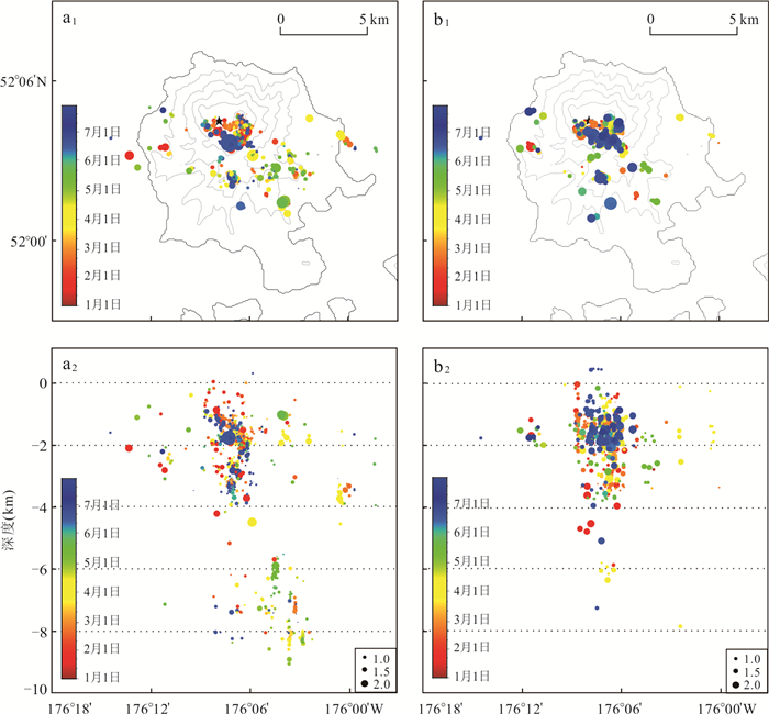
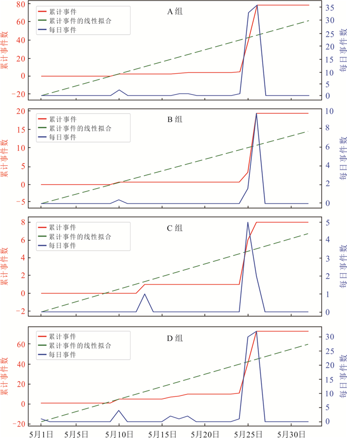
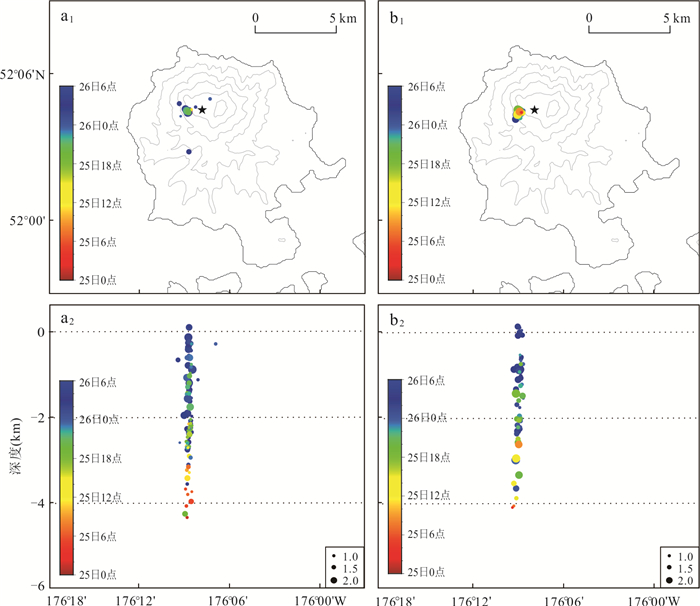
The spatiotemporal characteristics of volcanic seismicity provide critical constraints for deciphering magma migration processes and eruption precursors. To elucidate the magmatic activity mechanisms preceding the 2021 eruption of the Great Sitkin Volcano, Alaska, this study conducted a systematic analysis of the pre-eruptive continuous seismic waveform data from the volcano. Template matching and the double-difference relocation method were employed to detect seismic events and achieve high-precision relocation. An unsupervised hierarchical clustering algorithm was then applied to classify volcanic seismicity and analyze its spatiotemporal evolution based on the constructed seismic catalog. The resulted seismic catalog contains four times the number of events compared to the official Alaska Volcano Observatory (AVO) catalog. Hierarchical clustering successfully categorized the seismic events into long-period (LP) earthquakes and volcano-tectonic (VT) earthquakes. The results show that a significant intensification of volcano seismic activity was observed prior to the eruption, with shallow LP events reaching an activity peak 24 hours before the eruption, and it is possible that the phenomenon potentially represents critical eruption precursor signals. The eruption was mainly triggered by magma accumulation and pressurization at upper-crustal depths directly beneath the summit crater.
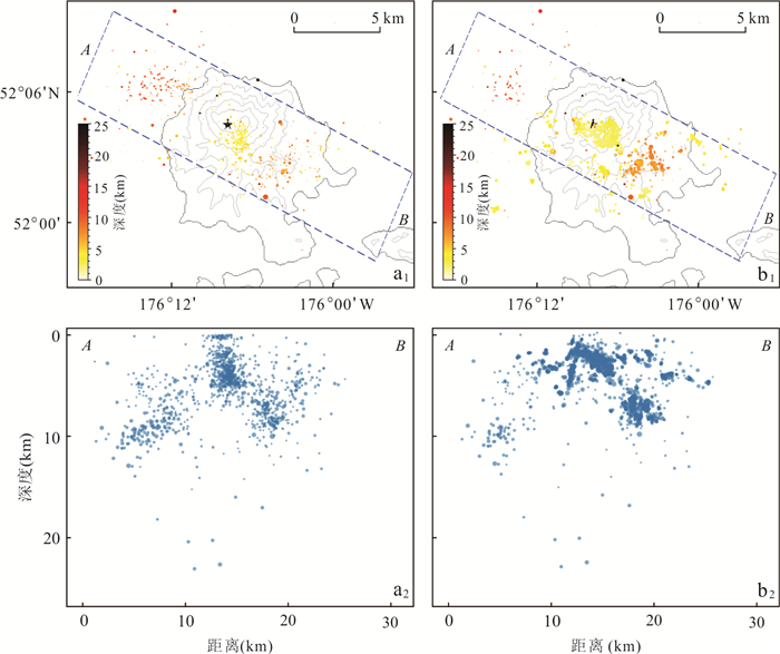
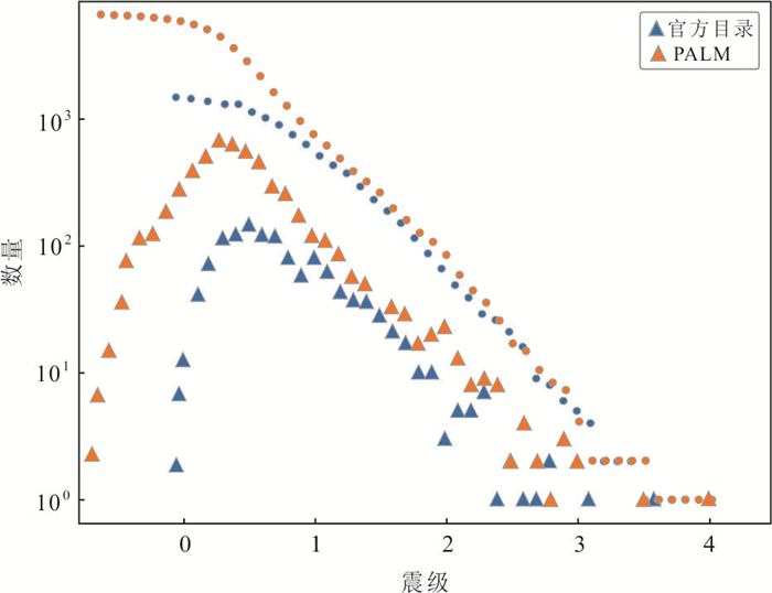
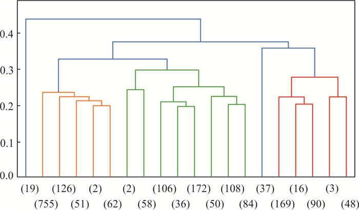
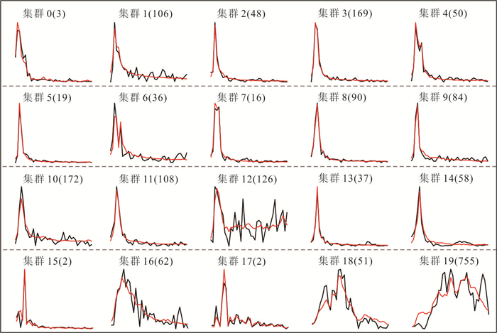
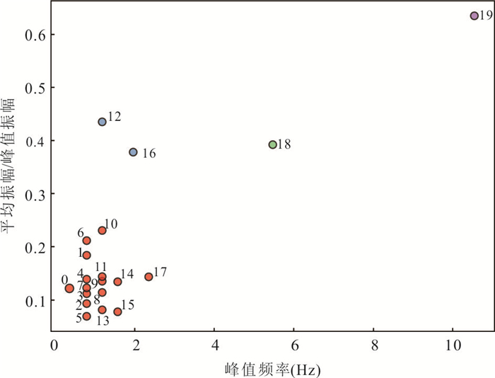
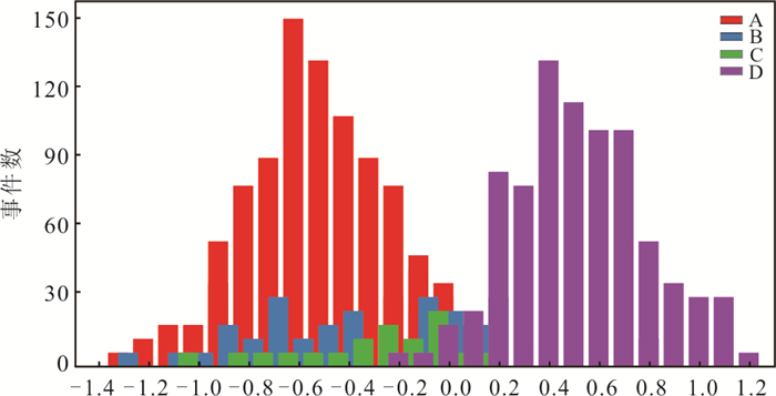
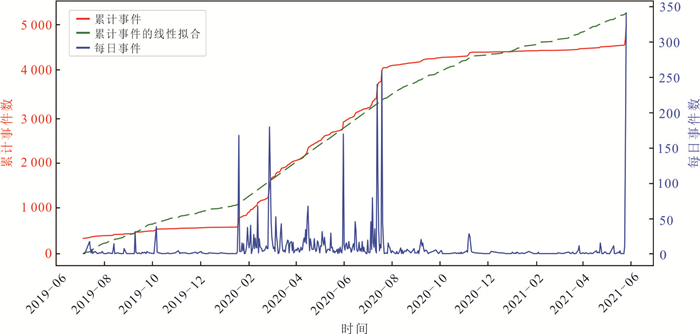
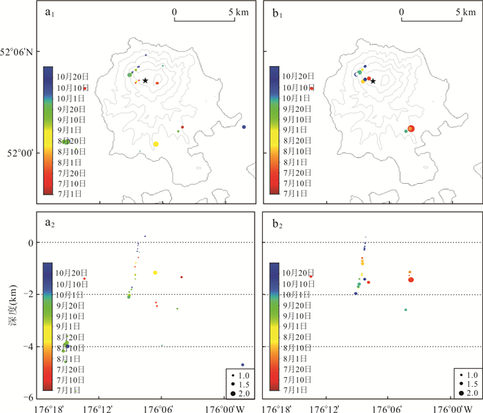
The spatiotemporal characteristics of volcanic seismicity provide critical constraints for deciphering magma migration processes and eruption precursors. To elucidate the magmatic activity mechanisms preceding the 2021 eruption of the Great Sitkin Volcano, Alaska, this study conducted a systematic analysis of the pre-eruptive continuous seismic waveform data from the volcano. Template matching and the double-difference relocation method were employed to detect seismic events and achieve high-precision relocation. An unsupervised hierarchical clustering algorithm was then applied to classify volcanic seismicity and analyze its spatiotemporal evolution based on the constructed seismic catalog. The resulted seismic catalog contains four times the number of events compared to the official Alaska Volcano Observatory (AVO) catalog. Hierarchical clustering successfully categorized the seismic events into long-period (LP) earthquakes and volcano-tectonic (VT) earthquakes. The results show that a significant intensification of volcano seismic activity was observed prior to the eruption, with shallow LP events reaching an activity peak 24 hours before the eruption, and it is possible that the phenomenon potentially represents critical eruption precursor signals. The eruption was mainly triggered by magma accumulation and pressurization at upper-crustal depths directly beneath the summit crater.
2026, 51(1): 160-172.
doi: 10.3799/dqkx.2025.236
Abstract:
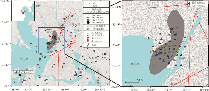
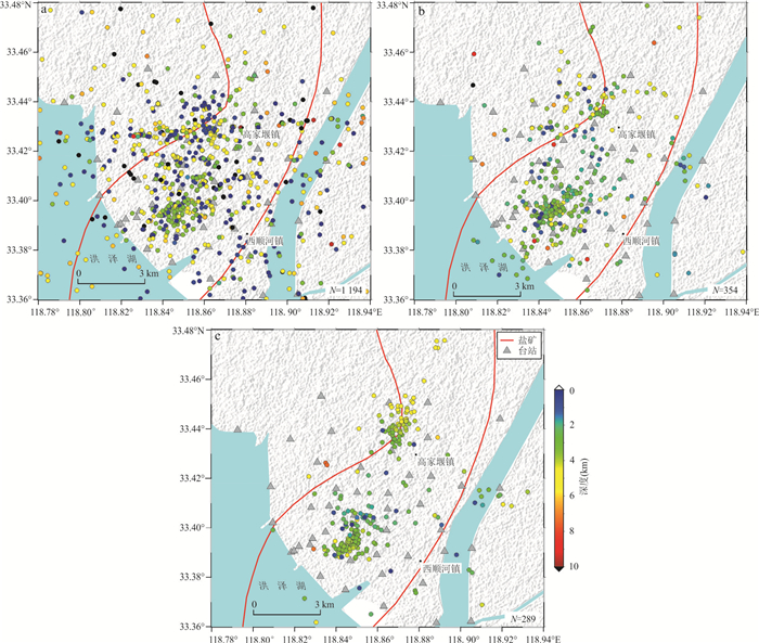
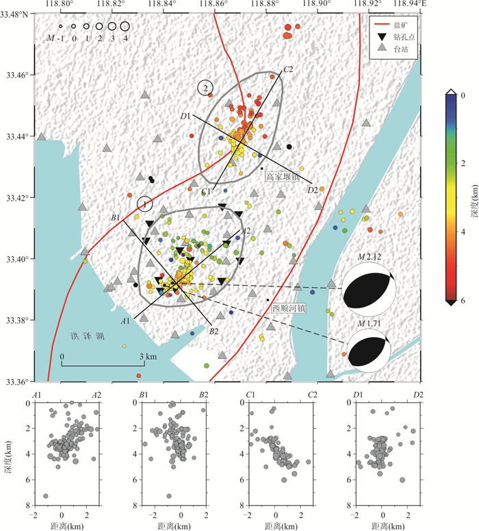
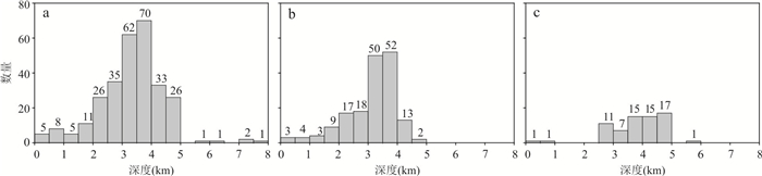
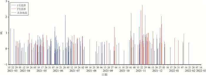
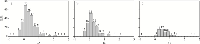
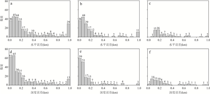
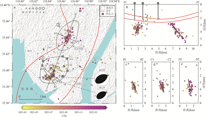
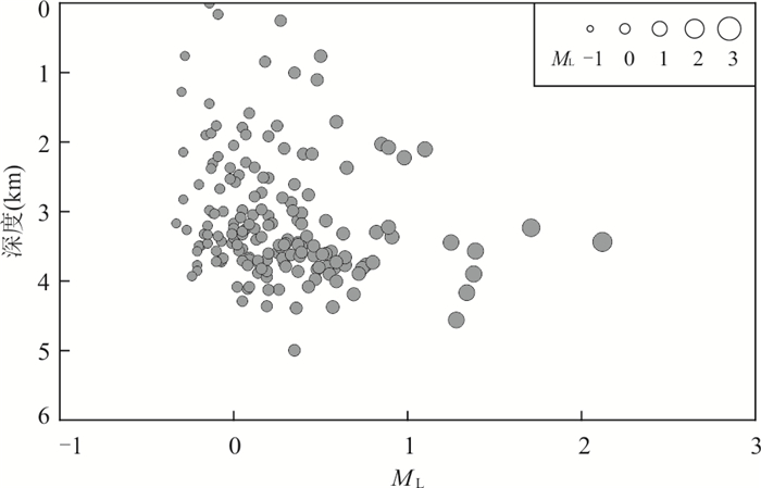
In 2021, the small earthquake activity significantly increased in the short term. To investigate the relationship between seismic activity and salt mining in the region, it deployed a dense array of 54 short period seismographs in the salt mining area and carried out a one-year microseismic monitoring. The high-resolution earthquake catalog for mining areas, constructed using deep learning earthquake automatic detection methods and absolute and relative repositioning, greatly improves the accuracy of locating the epicenter position, especially the depth of the earthquake source, of small earthquakes in mining areas, effectively enhancing the monitoring ability of seismic activity in small-scale salt mining areas. Combined with the industrial production background and geological conditions of the area, the following main understandings are obtained. The mining area is mainly characterized by microseismic activity, which is distributed in two independent earthquake clusters in space. The cluster 1 is located below the salt well, with a significantly shallower depth of the earthquake source than the cluster 2. The cluster 2 is located in the surface water inflow area that several kilometers far from the salt well, and lags behind the cluster 1 by about 8 months in time. After analysis, it is possible that the cluster 1 is directly related to mining activities, while the cluster 2 may be related to local fault activation caused by fluid diffusion. This study indicates that based on dense array covering mining areas and intelligent detection technology, the understanding of the distribution characteristics and seismic mechanisms of small earthquakes in salt mining areas can be greatly improved, which can provide key basis for optimizing production control plans.
In 2021, the small earthquake activity significantly increased in the short term. To investigate the relationship between seismic activity and salt mining in the region, it deployed a dense array of 54 short period seismographs in the salt mining area and carried out a one-year microseismic monitoring. The high-resolution earthquake catalog for mining areas, constructed using deep learning earthquake automatic detection methods and absolute and relative repositioning, greatly improves the accuracy of locating the epicenter position, especially the depth of the earthquake source, of small earthquakes in mining areas, effectively enhancing the monitoring ability of seismic activity in small-scale salt mining areas. Combined with the industrial production background and geological conditions of the area, the following main understandings are obtained. The mining area is mainly characterized by microseismic activity, which is distributed in two independent earthquake clusters in space. The cluster 1 is located below the salt well, with a significantly shallower depth of the earthquake source than the cluster 2. The cluster 2 is located in the surface water inflow area that several kilometers far from the salt well, and lags behind the cluster 1 by about 8 months in time. After analysis, it is possible that the cluster 1 is directly related to mining activities, while the cluster 2 may be related to local fault activation caused by fluid diffusion. This study indicates that based on dense array covering mining areas and intelligent detection technology, the understanding of the distribution characteristics and seismic mechanisms of small earthquakes in salt mining areas can be greatly improved, which can provide key basis for optimizing production control plans.
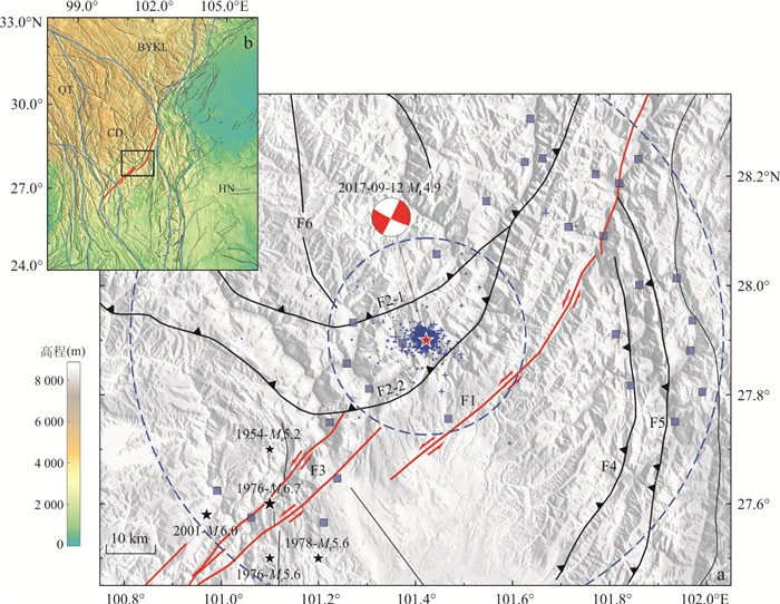
2017 ML4.9/MS4.4 Muli, Sichuan, Earthquake Sequence: A High-Precision Seismic Catalog Reconstruction
2026, 51(1): 173-184.
doi: 10.3799/dqkx.2025.206
Abstract:
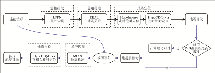
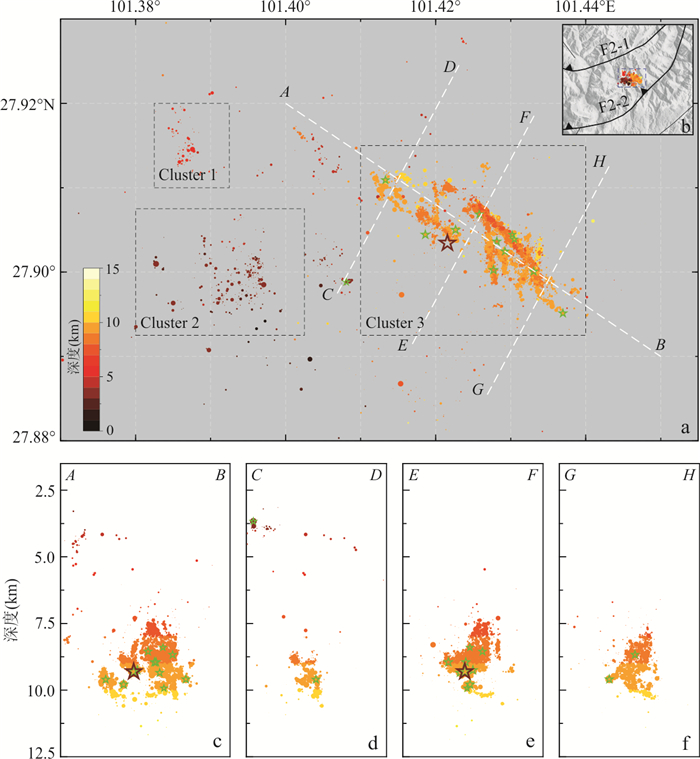
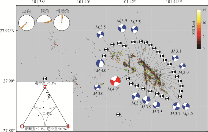
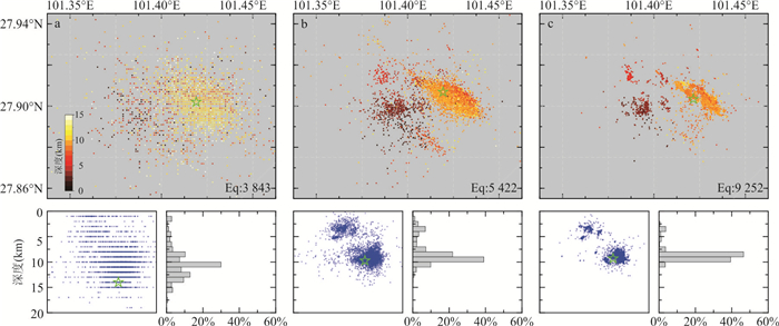
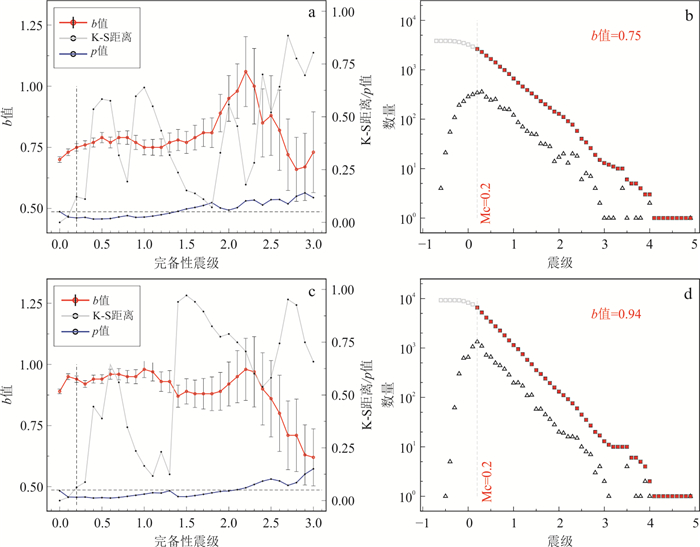
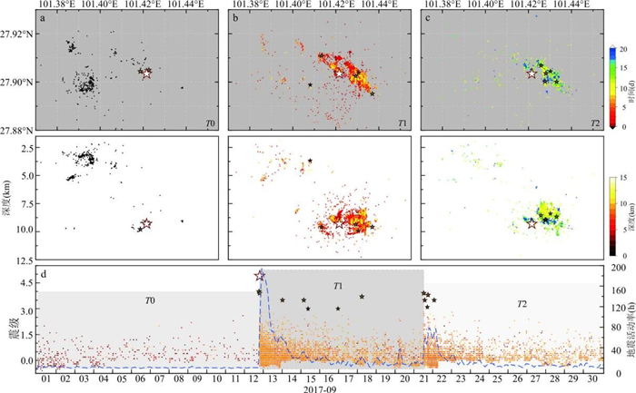
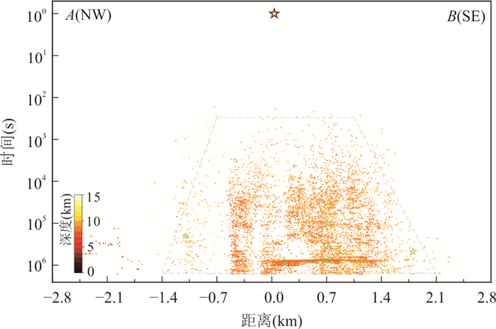
To investigate the characteristics of the 2017 ML4.9/MS4.4 earthquake sequence in Muli, Sichuan, an end-to-end framework, involving raw continuous seismic waveform data processing to seismic phase detection, earthquake event identification, and earthquake location, was constructed based on lightweight artificial intelligence methods, template matching techniques, and earthquake location methods. This system was used to process raw waveform data from 28 stations within a 60 km radius of the epicentral area between September 1 and 30, 2017, reconstructing a high-resolution seismic catalog containing 9 252 foreshocks, mainshocks, and aftershocks. Based on focal mechanism solutions of 43 ML≥2.5 earthquakes, it conducted a comprehensive analysis of the seismicity patterns.The refined catalog exhibits enhanced consistency with Gutenberg-Richter magnitude-frequency statistics and clearly delineates spatiotemporal evolutionary features.The seismic sequence occurred within a complex NW-SE trending strike-slip fault system bounded by the Jinpingshan Fault, with the bilateral expansion of events from the mainshock toward the NW and SE, and it was preliminarily attributed to driving by afterslip.
To investigate the characteristics of the 2017 ML4.9/MS4.4 earthquake sequence in Muli, Sichuan, an end-to-end framework, involving raw continuous seismic waveform data processing to seismic phase detection, earthquake event identification, and earthquake location, was constructed based on lightweight artificial intelligence methods, template matching techniques, and earthquake location methods. This system was used to process raw waveform data from 28 stations within a 60 km radius of the epicentral area between September 1 and 30, 2017, reconstructing a high-resolution seismic catalog containing 9 252 foreshocks, mainshocks, and aftershocks. Based on focal mechanism solutions of 43 ML≥2.5 earthquakes, it conducted a comprehensive analysis of the seismicity patterns.The refined catalog exhibits enhanced consistency with Gutenberg-Richter magnitude-frequency statistics and clearly delineates spatiotemporal evolutionary features.The seismic sequence occurred within a complex NW-SE trending strike-slip fault system bounded by the Jinpingshan Fault, with the bilateral expansion of events from the mainshock toward the NW and SE, and it was preliminarily attributed to driving by afterslip.
2026, 51(1): 185-198.
doi: 10.3799/dqkx.2025.233
Abstract:
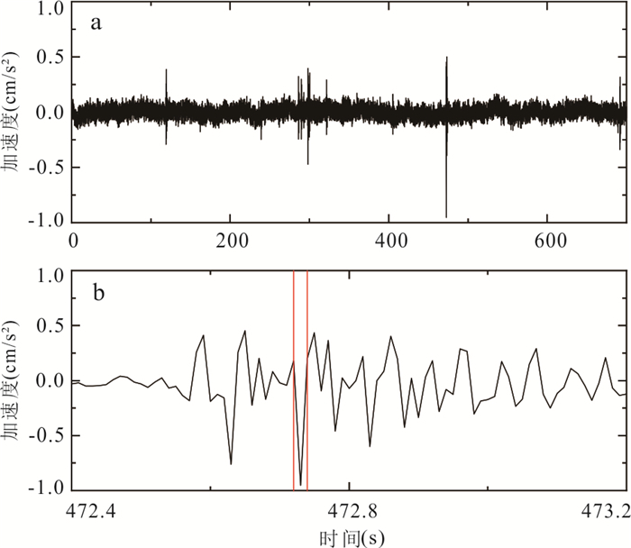
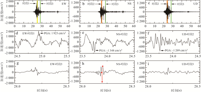
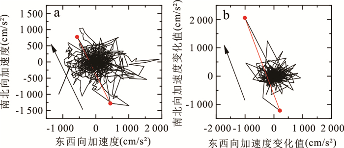
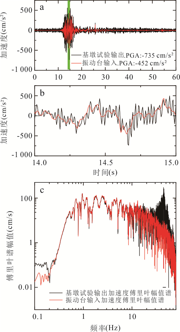
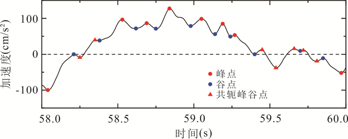
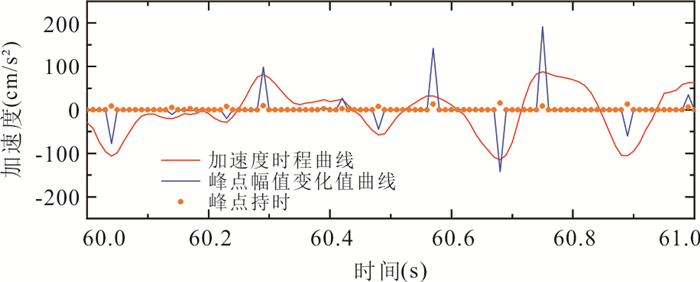
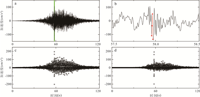
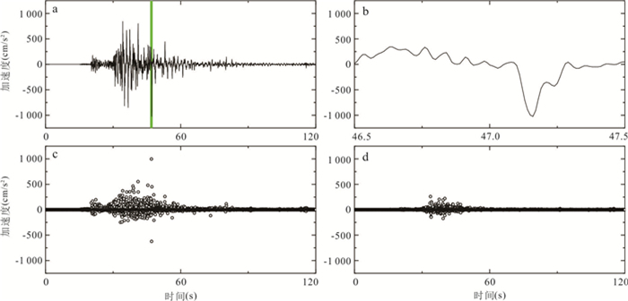
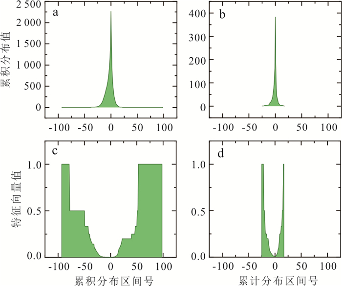
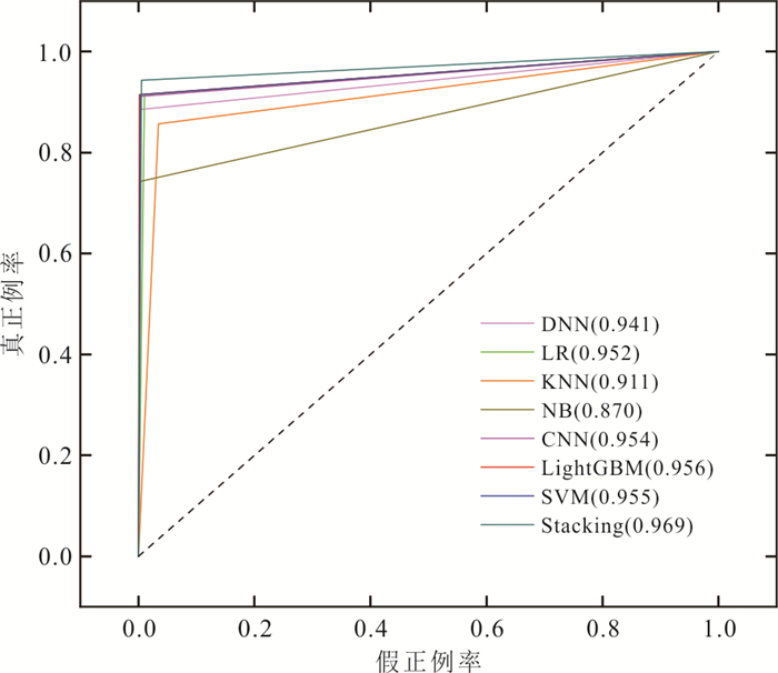
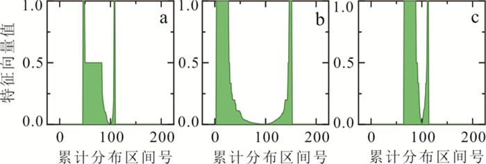
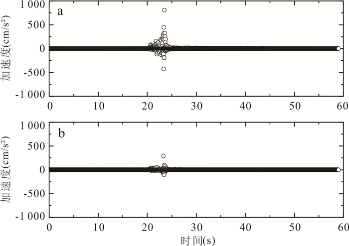
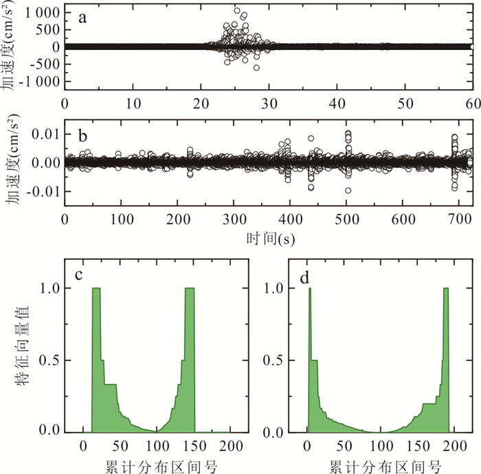
Spike in strong-motion record is a common type of abnormal waveform. However, their generation mechanism remains unclear and requires the accumulation of large datasets for further study, making spike identification highly significant. This study proposes a preprocessing method based on adaptive waveform scaling to extract and enhance amplitude variation features, combined with time-scale discrimination criteria, thereby reducing the impact of amplitude differences on manual annotation accuracy. In addition, a novel feature representation approach is introduced, in which one-dimensional data are transformed into feature vectors by normalizing the cumulative distribution of sampling amplitudes, enabling the spatial distribution characteristics of strong-motion records to be represented. Using a highly imbalanced dataset, multiple machine learning models were trained, and cases of misclassification were analyzed. Furthermore, LightGBM-SVM stacking algorithm optimized with Bayesian optimization is adopted to achieve the recognition of spike waveforms, achieving a Matthews correlation coefficient (MCC) exceeding 86% on the test set. The results show that the proposed spike discrimination criterion achieved satisfactory performance, confirming its stability and generalizability. The method can serve as an auxiliary tool for spike waveform screening in data quality assessment and provide technical support for further investigations into the generation mechanism of spike waveforms.
Spike in strong-motion record is a common type of abnormal waveform. However, their generation mechanism remains unclear and requires the accumulation of large datasets for further study, making spike identification highly significant. This study proposes a preprocessing method based on adaptive waveform scaling to extract and enhance amplitude variation features, combined with time-scale discrimination criteria, thereby reducing the impact of amplitude differences on manual annotation accuracy. In addition, a novel feature representation approach is introduced, in which one-dimensional data are transformed into feature vectors by normalizing the cumulative distribution of sampling amplitudes, enabling the spatial distribution characteristics of strong-motion records to be represented. Using a highly imbalanced dataset, multiple machine learning models were trained, and cases of misclassification were analyzed. Furthermore, LightGBM-SVM stacking algorithm optimized with Bayesian optimization is adopted to achieve the recognition of spike waveforms, achieving a Matthews correlation coefficient (MCC) exceeding 86% on the test set. The results show that the proposed spike discrimination criterion achieved satisfactory performance, confirming its stability and generalizability. The method can serve as an auxiliary tool for spike waveform screening in data quality assessment and provide technical support for further investigations into the generation mechanism of spike waveforms.
2026, 51(1): 199-214.
doi: 10.3799/dqkx.2025.171
Abstract:
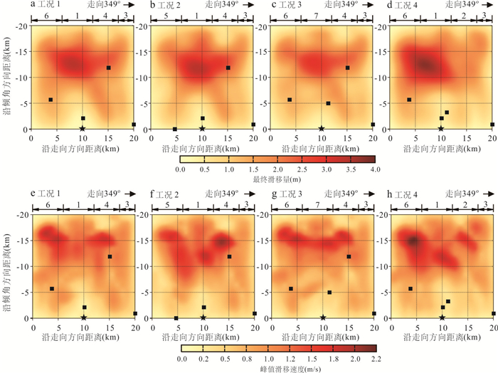
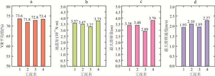
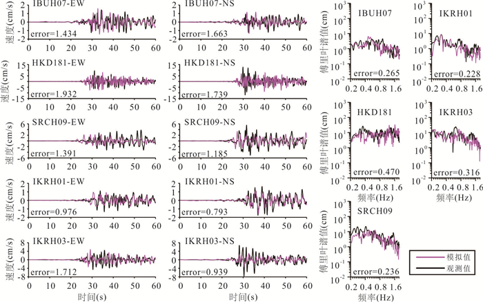
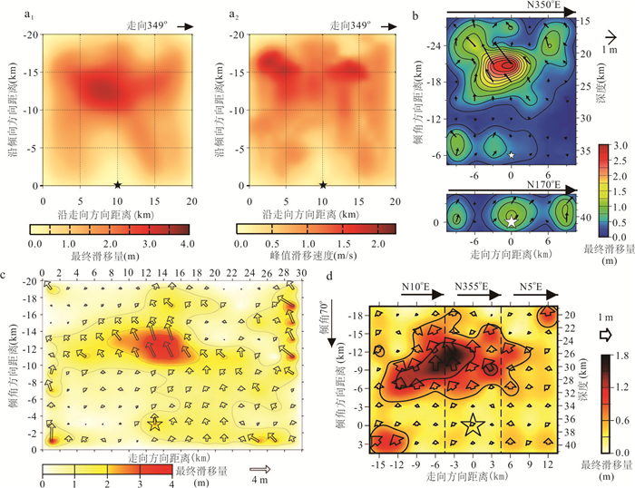
Conducting waveform inversions to estimate the rupture process of media to large size of earthquakes is one of the effective methods to better understand the characteristics of strong ground motions. To investigate the generation mechanism of strong ground motions, this study evaluates the rupture process of the 2018 Hokkaido, Japan, earthquake through waveform inversion based on the corrected empirical Green's functions. It is found that, large slip regions are concentrated along the shallow southwestern- to northeastern-section of the fault around 6.0 km in length and within 12.0 km from the hypocenter. Within this region, the maximum final slip approximates to 3.5 m; two peak slip velocity regions are identified, with the primary one located 6.0 km southwestern, and the secondary one located 4.0 km northeastern, and both within shallow areas 15.0 km from the hypocenter. The maximum peak slip velocity is about 2.0 m/s. A rupture velocity of 2.0 km/s is identified, and the inverted source model corresponds to a magnitude\begin{document}$ {M}_{W}7.0 $\end{document}
Conducting waveform inversions to estimate the rupture process of media to large size of earthquakes is one of the effective methods to better understand the characteristics of strong ground motions. To investigate the generation mechanism of strong ground motions, this study evaluates the rupture process of the 2018 Hokkaido, Japan, earthquake through waveform inversion based on the corrected empirical Green's functions. It is found that, large slip regions are concentrated along the shallow southwestern- to northeastern-section of the fault around 6.0 km in length and within 12.0 km from the hypocenter. Within this region, the maximum final slip approximates to 3.5 m; two peak slip velocity regions are identified, with the primary one located 6.0 km southwestern, and the secondary one located 4.0 km northeastern, and both within shallow areas 15.0 km from the hypocenter. The maximum peak slip velocity is about 2.0 m/s. A rupture velocity of 2.0 km/s is identified, and the inverted source model corresponds to a magnitude
2026, 51(1): 215-225.
doi: 10.3799/dqkx.2025.193
Abstract:
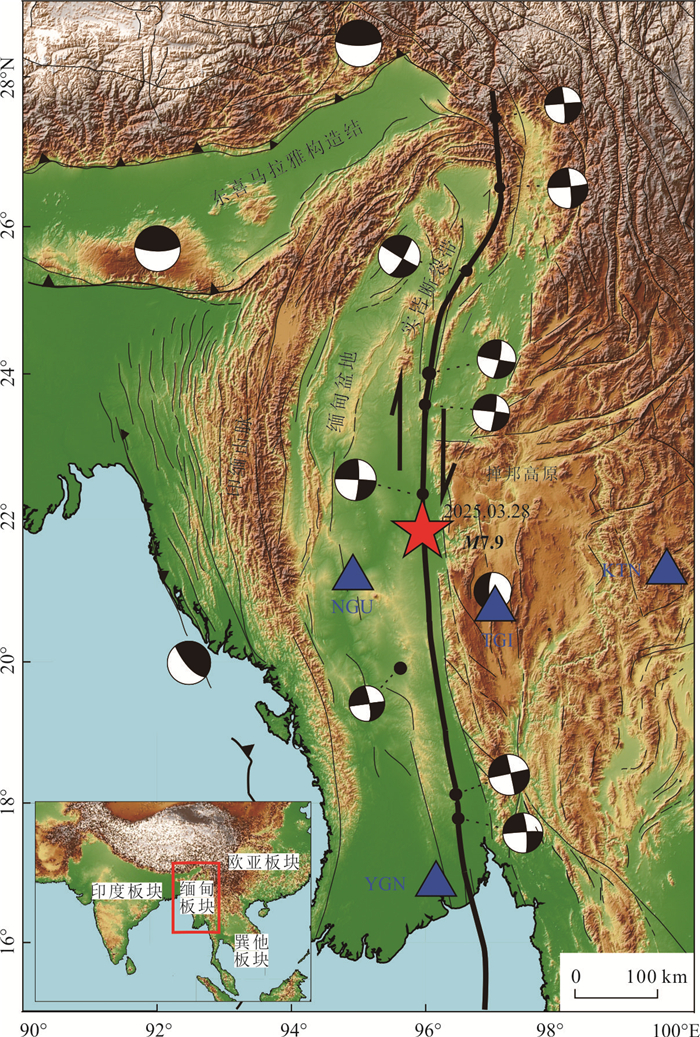
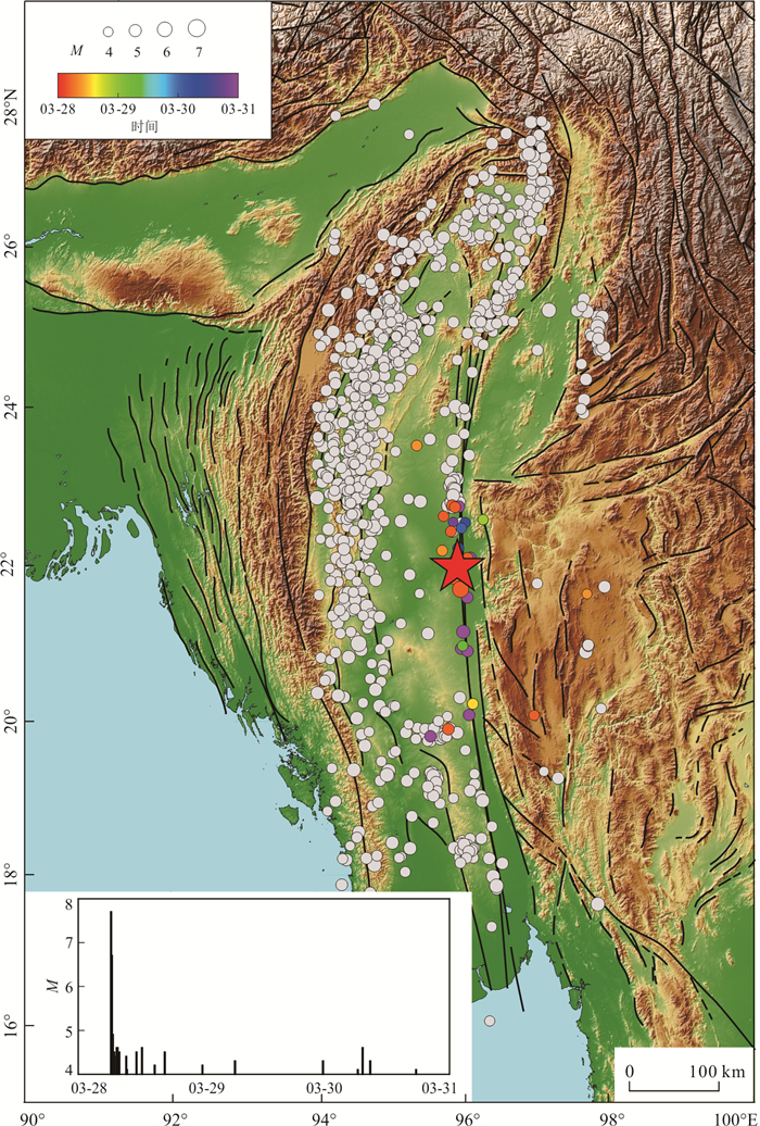
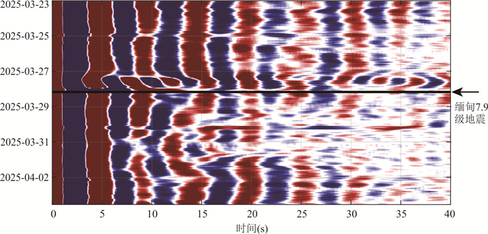
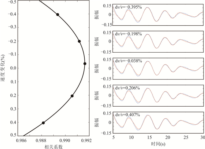
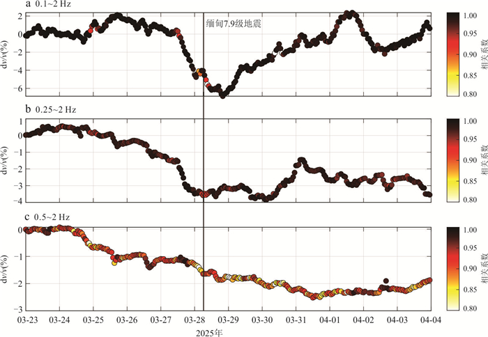
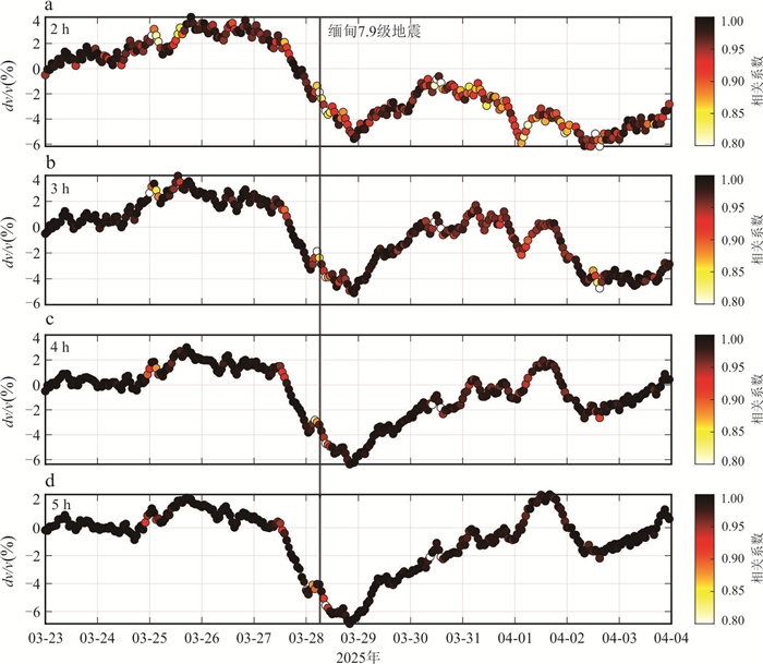
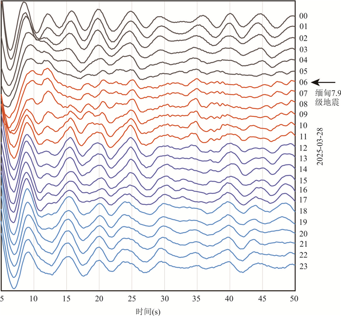
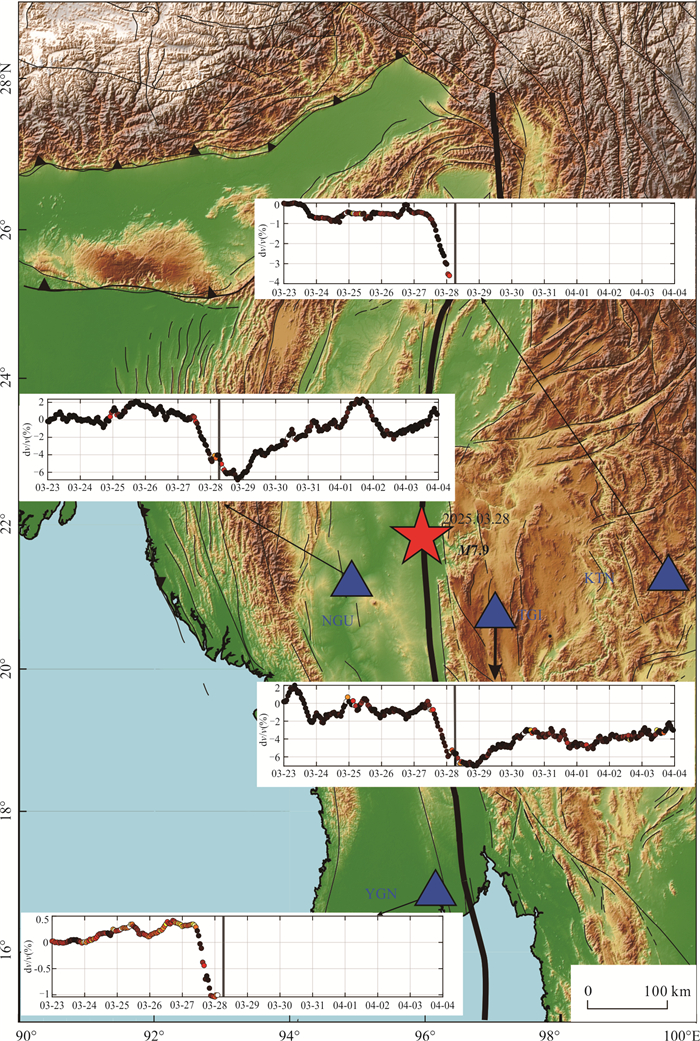
Seismic velocity change serves as a crucial indicator for characterizing the evolution of stress states in subsurface structure, providing significant insights into earthquake nucleation mechanisms, rupture processes, and postseismic adjustments. This study utilizes continuous waveform data from four permanent stations located in the source region of the March 28, 2025, Myanmar M7.9 earthquake. By applying the ambient noise autocorrelation method, we analyze the dynamic changes in seismic wave velocity during the pre-seismic, co-seismic, and post-seismic phases. The results reveal that all stations observed a notable decrease in seismic wave velocity within the frequency range of 0.1-2 Hz during the pre-seismic phase, which may be attributed to pre-seismic slip or progressive changes in the physical properties of the media along the Sagaing large-scale strike-slip fault zone. During the co-seismic phase, the velocity changes exhibit significant spatial heterogeneity, with stations closer to the epicenter showing more pronounced variations, indicating stronger near-field ground motion effects. In the post-seismic phase, the wave velocity gradually recovers over time, likely reflecting the self-healing process of the subsurface media beneath the seismic stations. These findings provide new observational evidence for understanding the seismogenic mechanisms of large strike-slip faults and the post-seismic healing processes of subsurface structure.
Seismic velocity change serves as a crucial indicator for characterizing the evolution of stress states in subsurface structure, providing significant insights into earthquake nucleation mechanisms, rupture processes, and postseismic adjustments. This study utilizes continuous waveform data from four permanent stations located in the source region of the March 28, 2025, Myanmar M7.9 earthquake. By applying the ambient noise autocorrelation method, we analyze the dynamic changes in seismic wave velocity during the pre-seismic, co-seismic, and post-seismic phases. The results reveal that all stations observed a notable decrease in seismic wave velocity within the frequency range of 0.1-2 Hz during the pre-seismic phase, which may be attributed to pre-seismic slip or progressive changes in the physical properties of the media along the Sagaing large-scale strike-slip fault zone. During the co-seismic phase, the velocity changes exhibit significant spatial heterogeneity, with stations closer to the epicenter showing more pronounced variations, indicating stronger near-field ground motion effects. In the post-seismic phase, the wave velocity gradually recovers over time, likely reflecting the self-healing process of the subsurface media beneath the seismic stations. These findings provide new observational evidence for understanding the seismogenic mechanisms of large strike-slip faults and the post-seismic healing processes of subsurface structure.
2026, 51(1): 226-239.
doi: 10.3799/dqkx.2025.132
Abstract:
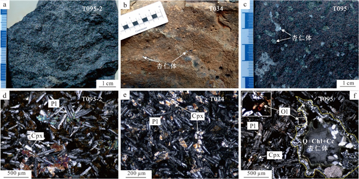
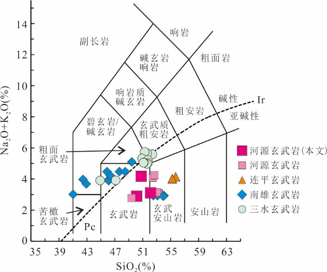
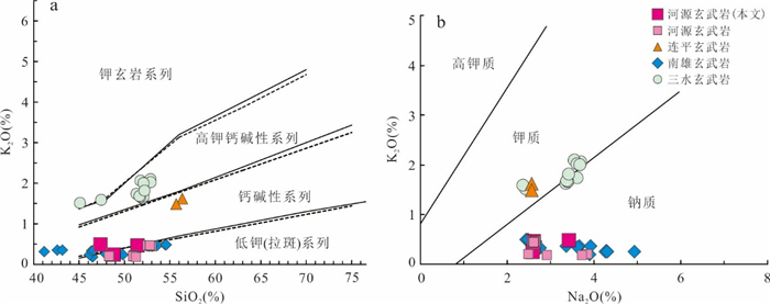
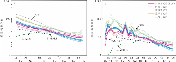
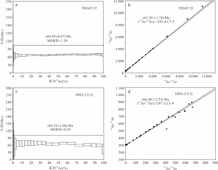
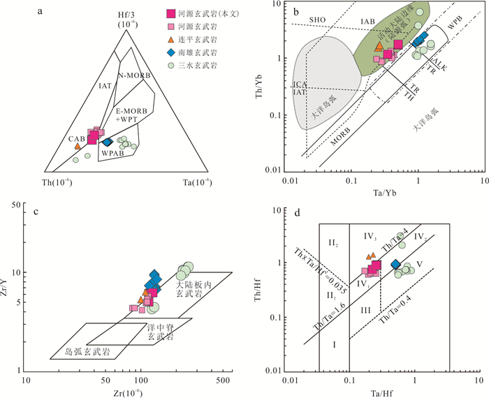
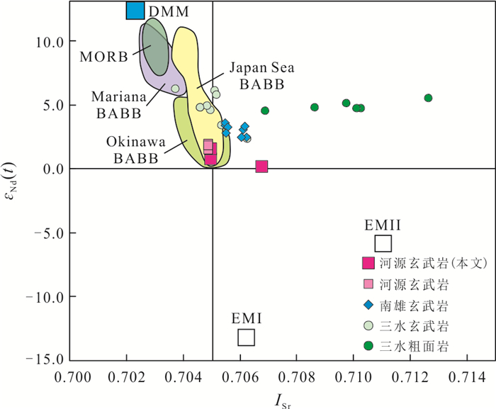
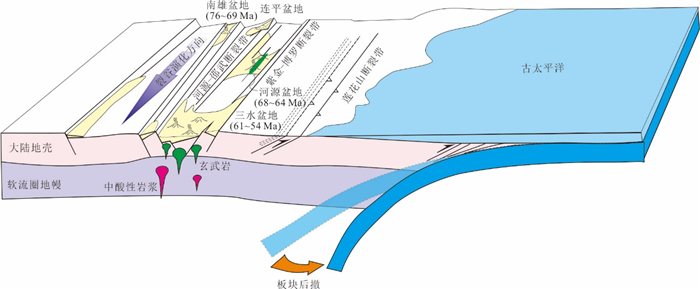
The formation and geodynamic setting of Mesozoic-Cenozoic volcanic rocks in the basins along the South China coast remain controversial, traditionally attributed to either Paleo-Pacific subduction or South China Sea spreading.Focusing on NE-trending fissure-erupted basalts from the Heyuan Basin, this study uses ⁴⁰Ar/³⁹Ar dating to constrain their eruption ages to 68.65-64.52 Ma. These ages coincide with the Cretaceous-Paleogene (K-Pg) boundary.Geochemically, the basalts exhibit sodic subalkaline tholeiitic characteristics (SiO2=47.43%-52.67%), with low Mg, K, and Ti but high Na and Al contents. Their rare earth element (REE) patterns indicate slight light REE(LREE) enrichment ((La/Yb)N=4.48-6.68), lacking significant Eu, Ce, Nb, or Ta anomalies, but displaying positive Ba, Th, and U anomalies and a negative P anomaly. Key elemental ratios (Th/Yb=1.72-1.15, Th/Nb=0.20-0.21, Hf/Th=1.13-1.35) suggest derivation from a depleted lithospheric mantle source with crustal contamination, formed in a continental rift setting.The Sr-Nd isotopic compositions (ISr=0.704 97-0.706 76, εNd(t)=0.11-1.55) indicate that the Heyuan basalts originated from a mixture of depleted mantle and enriched lithospheric mantle components. Regional comparisons with coeval basalts from the Nanxiong, Lianping, and Sanshui basins reveal an NE-SW trending continental rift system along the northern South China margin. This rifting episode likely responded to back-arc extension triggered by Paleo-Pacific plate rollback.
The formation and geodynamic setting of Mesozoic-Cenozoic volcanic rocks in the basins along the South China coast remain controversial, traditionally attributed to either Paleo-Pacific subduction or South China Sea spreading.Focusing on NE-trending fissure-erupted basalts from the Heyuan Basin, this study uses ⁴⁰Ar/³⁹Ar dating to constrain their eruption ages to 68.65-64.52 Ma. These ages coincide with the Cretaceous-Paleogene (K-Pg) boundary.Geochemically, the basalts exhibit sodic subalkaline tholeiitic characteristics (SiO2=47.43%-52.67%), with low Mg, K, and Ti but high Na and Al contents. Their rare earth element (REE) patterns indicate slight light REE(LREE) enrichment ((La/Yb)N=4.48-6.68), lacking significant Eu, Ce, Nb, or Ta anomalies, but displaying positive Ba, Th, and U anomalies and a negative P anomaly. Key elemental ratios (Th/Yb=1.72-1.15, Th/Nb=0.20-0.21, Hf/Th=1.13-1.35) suggest derivation from a depleted lithospheric mantle source with crustal contamination, formed in a continental rift setting.The Sr-Nd isotopic compositions (ISr=0.704 97-0.706 76, εNd(t)=0.11-1.55) indicate that the Heyuan basalts originated from a mixture of depleted mantle and enriched lithospheric mantle components. Regional comparisons with coeval basalts from the Nanxiong, Lianping, and Sanshui basins reveal an NE-SW trending continental rift system along the northern South China margin. This rifting episode likely responded to back-arc extension triggered by Paleo-Pacific plate rollback.

2026, 51(1): 240-256.
doi: 10.3799/dqkx.2025.299
Abstract:
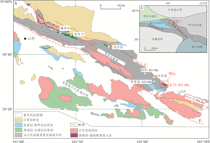
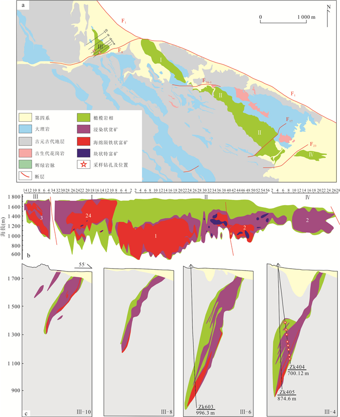
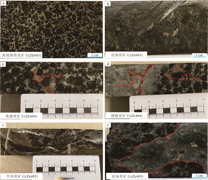
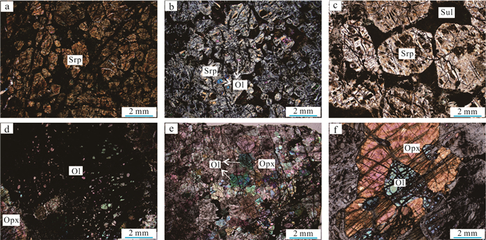
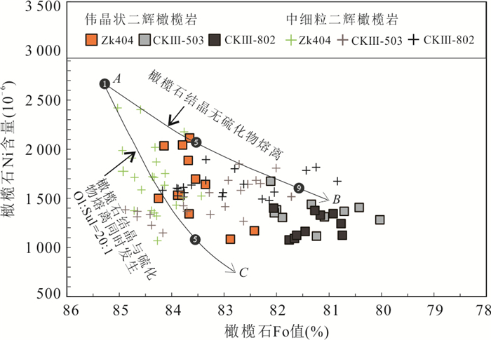
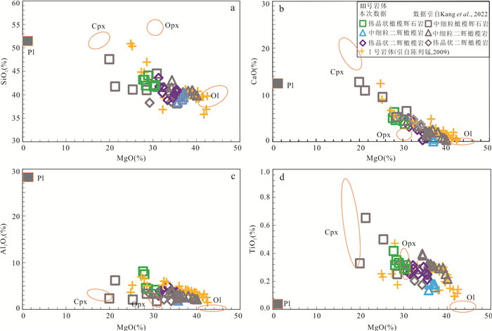
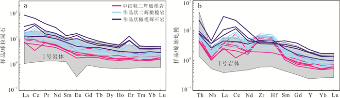
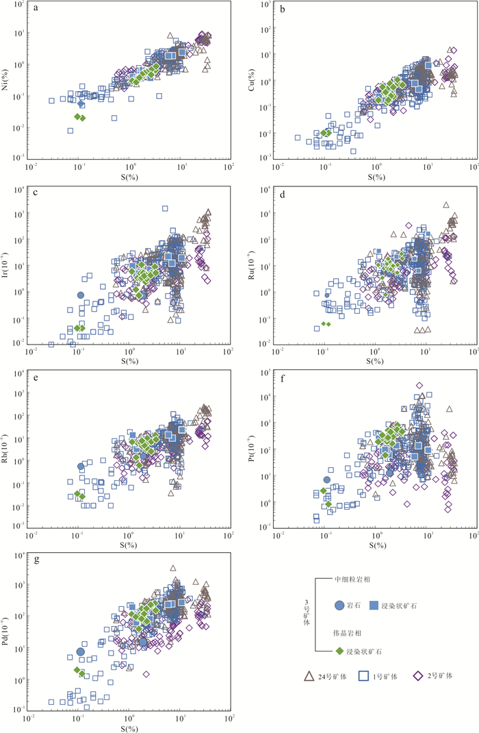
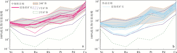
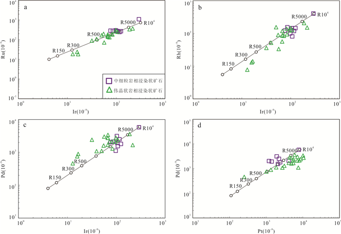
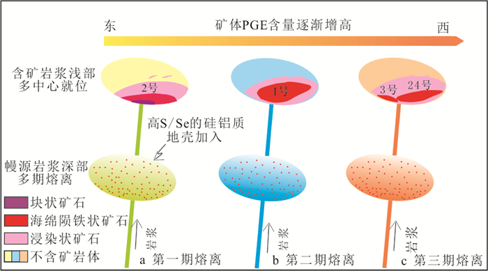
To elucidate the mineralization process of the No.3 orebody of the Jinchuan deposit and to refine the Jinchuan metallogenic model, it conducted EPMA of ore minerals together with whole-rock major-trace element and Ni-Cu-PGE analyses. Olivine from the fine-grained and pegmatitic lherzolite hosting the No.3 orebody shows Fo values of 82.4%-85.0% and Ni contents of 1 069×10-6-2 420×10-6. Both Fo and olivine Ni content increase progressively from the northwest to the southeast. Major-element variations suggest that the No.3 orebody experienced dominantly olivine- and pyroxene-controlled fractional crystallization. The ore-bearing rocks are slightly enriched in light rare earth elements (LREE), markedly enriched in large-ion lithophile elements (LILE), and depleted in high-field-strength elements (HFSE). The total PGE abundances of the No.3 orebody are comparable to those of the No.24 orebody, but are significantly higher than those of the No.1 and No.2 orebodies. Importantly, the southeastern segment of the No.3 orebody remains relatively more mafic and therefore retains greater mineralization potential. These observations support a metallogenic model in which the Jinchuan deposit formed through "mantle-derived magma, sulfide segregation, and multi-center emplacement of mineralized magma". The No.3 and No.24 orebodies were supplied by the same magma conduit, whereas the No. 1 and No. 2 orebodies were fed by separate conduits.
To elucidate the mineralization process of the No.3 orebody of the Jinchuan deposit and to refine the Jinchuan metallogenic model, it conducted EPMA of ore minerals together with whole-rock major-trace element and Ni-Cu-PGE analyses. Olivine from the fine-grained and pegmatitic lherzolite hosting the No.3 orebody shows Fo values of 82.4%-85.0% and Ni contents of 1 069×10-6-2 420×10-6. Both Fo and olivine Ni content increase progressively from the northwest to the southeast. Major-element variations suggest that the No.3 orebody experienced dominantly olivine- and pyroxene-controlled fractional crystallization. The ore-bearing rocks are slightly enriched in light rare earth elements (LREE), markedly enriched in large-ion lithophile elements (LILE), and depleted in high-field-strength elements (HFSE). The total PGE abundances of the No.3 orebody are comparable to those of the No.24 orebody, but are significantly higher than those of the No.1 and No.2 orebodies. Importantly, the southeastern segment of the No.3 orebody remains relatively more mafic and therefore retains greater mineralization potential. These observations support a metallogenic model in which the Jinchuan deposit formed through "mantle-derived magma, sulfide segregation, and multi-center emplacement of mineralized magma". The No.3 and No.24 orebodies were supplied by the same magma conduit, whereas the No. 1 and No. 2 orebodies were fed by separate conduits.
2026, 51(1): 257-271.
doi: 10.3799/dqkx.2025.066
Abstract:
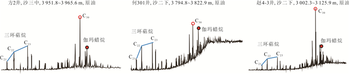
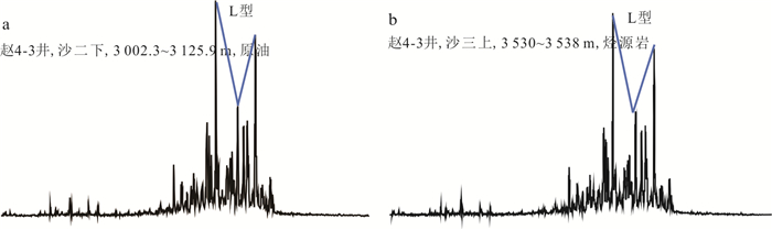
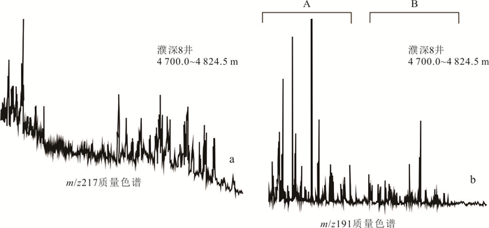
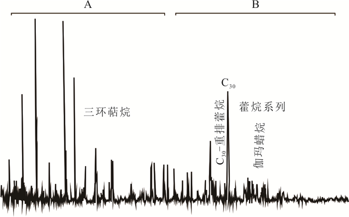
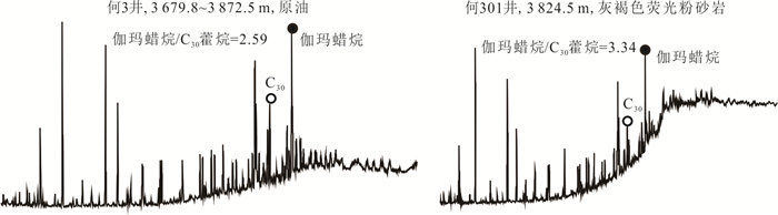
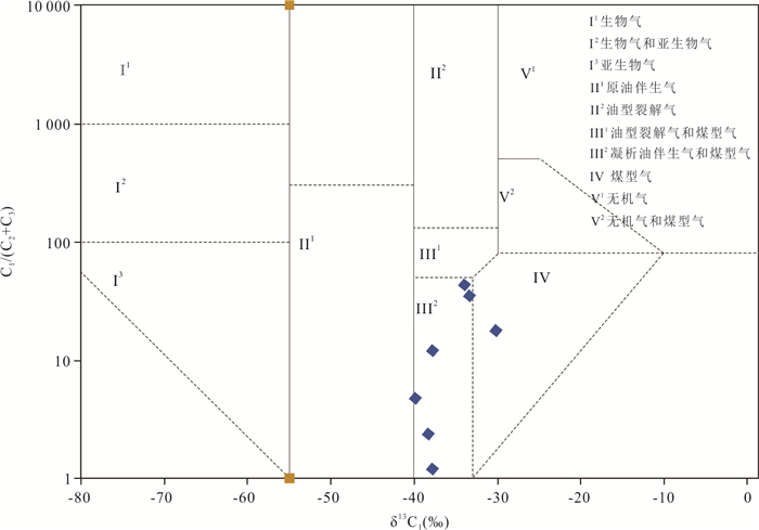
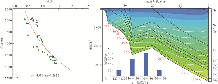
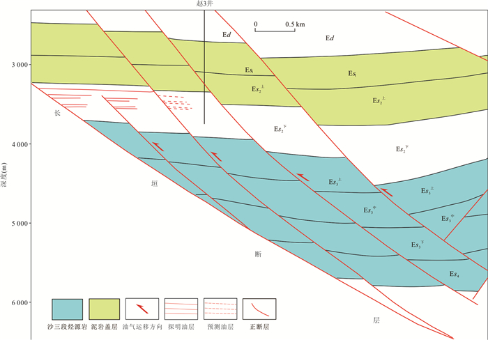
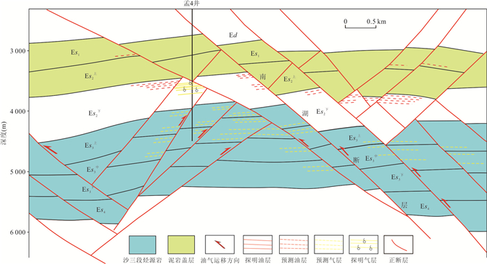
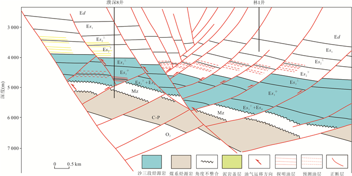
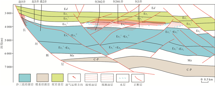
To address the challenge of increasing reserves and preserving mining rights in old oil fields, particularly in the underexplored southwestern depression of the Dongpu Depression, this study employed saturation hydrocarbon chromatography and natural gas carbon isotope analysis to investigate the oil and gas sources and their entrapment patterns. The results revealed three types of crude oils and two types of natural gases in the area, namely, the low gammacerane index crude oil, medium gammacerane index crude oil, and high gammacerane index crude oil, as well as Upper Paleozoic coal-derived gas and a mixture of coal-derived gas and oil-type gas. Oil-source correlation indicates that low gammacerane index crude oil primarily originates from freshwater source rocks in the middle third submember of the Shahejie Formation. Medium gammacerane index crude oil mainly comes from saline source rocks in the upper third submember of the Shahejie Formation. High gammacerane index crude oil predominantly stems from hypersaline source rocks in the lower third submember of the Shahejie Formation. The oil and gas in the Southwest Sag exhibit a "multi-source hydrocarbon supply, structure-controlled reservoir, and fault-sand controlled richness" entrapment characteristic. Four distinct types of oil and gas entrapment patterns were identified: multi-level fault steps, Y-shaped, inverted Y-shaped, and negative flower-like. Major fault plays a controlling role in the entrapment of oil and gas in the Southwest Sag. The breakthrough understanding of hydrocarbon source rocks and entrapment mechanisms is critical to the successful exploration of underexplored areas in old oil fields. These findings provide valuable insights and reference significance for similar basins, particularly in optimizing strategies exploration and enhancing reserve discovery in old oil fields.
To address the challenge of increasing reserves and preserving mining rights in old oil fields, particularly in the underexplored southwestern depression of the Dongpu Depression, this study employed saturation hydrocarbon chromatography and natural gas carbon isotope analysis to investigate the oil and gas sources and their entrapment patterns. The results revealed three types of crude oils and two types of natural gases in the area, namely, the low gammacerane index crude oil, medium gammacerane index crude oil, and high gammacerane index crude oil, as well as Upper Paleozoic coal-derived gas and a mixture of coal-derived gas and oil-type gas. Oil-source correlation indicates that low gammacerane index crude oil primarily originates from freshwater source rocks in the middle third submember of the Shahejie Formation. Medium gammacerane index crude oil mainly comes from saline source rocks in the upper third submember of the Shahejie Formation. High gammacerane index crude oil predominantly stems from hypersaline source rocks in the lower third submember of the Shahejie Formation. The oil and gas in the Southwest Sag exhibit a "multi-source hydrocarbon supply, structure-controlled reservoir, and fault-sand controlled richness" entrapment characteristic. Four distinct types of oil and gas entrapment patterns were identified: multi-level fault steps, Y-shaped, inverted Y-shaped, and negative flower-like. Major fault plays a controlling role in the entrapment of oil and gas in the Southwest Sag. The breakthrough understanding of hydrocarbon source rocks and entrapment mechanisms is critical to the successful exploration of underexplored areas in old oil fields. These findings provide valuable insights and reference significance for similar basins, particularly in optimizing strategies exploration and enhancing reserve discovery in old oil fields.
2026, 51(1): 272-283.
doi: 10.3799/dqkx.2025.221
Abstract:
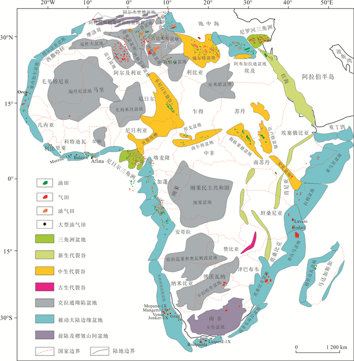
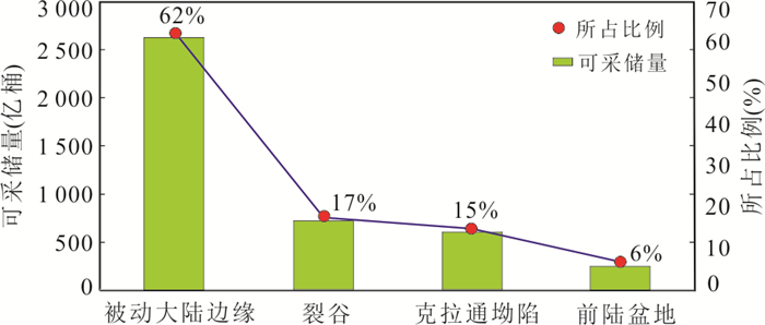
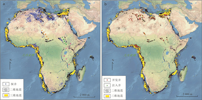
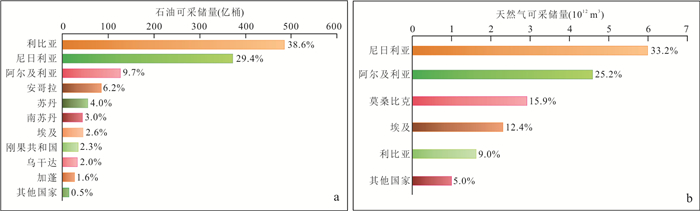
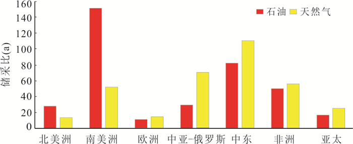
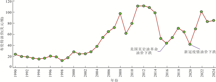
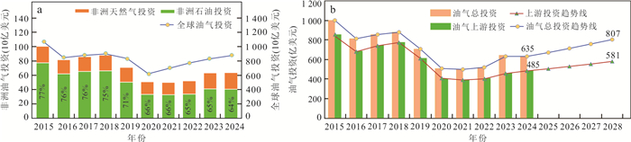
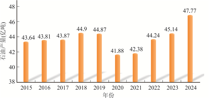
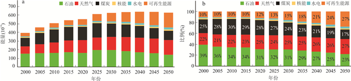
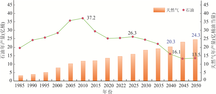
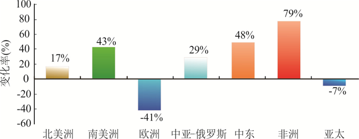
Based on commercial databases such as S&P Global and the International Energy Agency (IEA), as well as public information from international oil companies like BP, this study systematically analyzes and researches the distribution characteristics of oil and gas resources in Africa, oil and gas discoveries, future exploration and development potential, and the current status and trends of oil and gas investment, so as to clarify the future exploration and development prospects and oil and gas investment directions in Africa. The study shows follows. (1) Africa is rich in oil and gas resources, but the exploration degree and oil and gas discoveries are uneven. Geographically, North Africa and West Africa have a high degree of oil and gas exploration, large discovered reserves, and are traditional oil-producing powers. East Africa and South Africa have a low exploration degree and small discovered reserves, but they are emerging hotspots for natural gas exploration. Geologically, passive continental margin basins are the most oil and gas-enriched, accounting for 62%, followed by rift basins and craton basins. (2) Africa has great potential for oil and gas exploration and development. The reserve-production ratio of discovered resources is high, and the medium- and long-term development potential is favorable. There are many remaining prospects with undiscovered resources, showing great potential for future exploration and development.Among them, the remaining prospect resources in offshore areas account for 82.5%, making them the focus of future exploration. (3) Driven by the strong growth of global oil and gas investment, Africa's oil and gas investment has recovered rapidly after the pandemic, and oil and gas production has rebounded rapidly. In particular, natural gas production has exceeded the pre-pandemic level, and Africa has become an important source of oil and gas imports for Europe and the Asia-Pacific region. (4) With the increasing demand for natural gas due to energy transition, natural gas will gradually surpass oil to become the main body of Africa's future oil and gas composition and an important investment target. Africa's marine areas, especially deepwater exploration, have huge potential and represent a realistic field for obtaining large-scale discoveries and investment. Unconventional resources in Africa have great potential, but they require high technology and costs, making them potential fields for large-scale reserve addition and investment in mature basins in the future.
Based on commercial databases such as S&P Global and the International Energy Agency (IEA), as well as public information from international oil companies like BP, this study systematically analyzes and researches the distribution characteristics of oil and gas resources in Africa, oil and gas discoveries, future exploration and development potential, and the current status and trends of oil and gas investment, so as to clarify the future exploration and development prospects and oil and gas investment directions in Africa. The study shows follows. (1) Africa is rich in oil and gas resources, but the exploration degree and oil and gas discoveries are uneven. Geographically, North Africa and West Africa have a high degree of oil and gas exploration, large discovered reserves, and are traditional oil-producing powers. East Africa and South Africa have a low exploration degree and small discovered reserves, but they are emerging hotspots for natural gas exploration. Geologically, passive continental margin basins are the most oil and gas-enriched, accounting for 62%, followed by rift basins and craton basins. (2) Africa has great potential for oil and gas exploration and development. The reserve-production ratio of discovered resources is high, and the medium- and long-term development potential is favorable. There are many remaining prospects with undiscovered resources, showing great potential for future exploration and development.Among them, the remaining prospect resources in offshore areas account for 82.5%, making them the focus of future exploration. (3) Driven by the strong growth of global oil and gas investment, Africa's oil and gas investment has recovered rapidly after the pandemic, and oil and gas production has rebounded rapidly. In particular, natural gas production has exceeded the pre-pandemic level, and Africa has become an important source of oil and gas imports for Europe and the Asia-Pacific region. (4) With the increasing demand for natural gas due to energy transition, natural gas will gradually surpass oil to become the main body of Africa's future oil and gas composition and an important investment target. Africa's marine areas, especially deepwater exploration, have huge potential and represent a realistic field for obtaining large-scale discoveries and investment. Unconventional resources in Africa have great potential, but they require high technology and costs, making them potential fields for large-scale reserve addition and investment in mature basins in the future.

2026, 51(1): 284-302.
doi: 10.3799/dqkx.2025.231
Abstract:
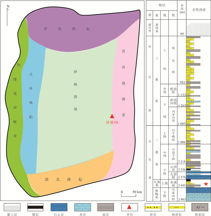
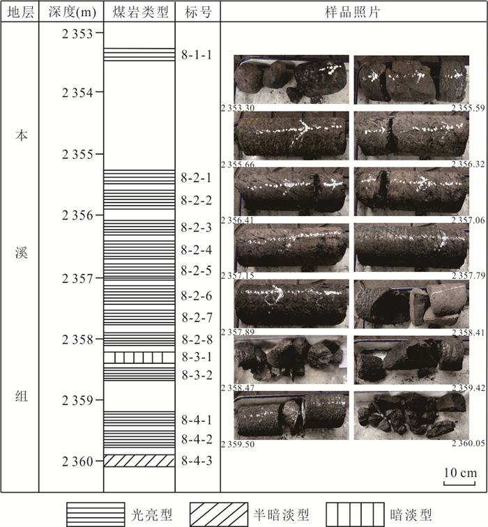
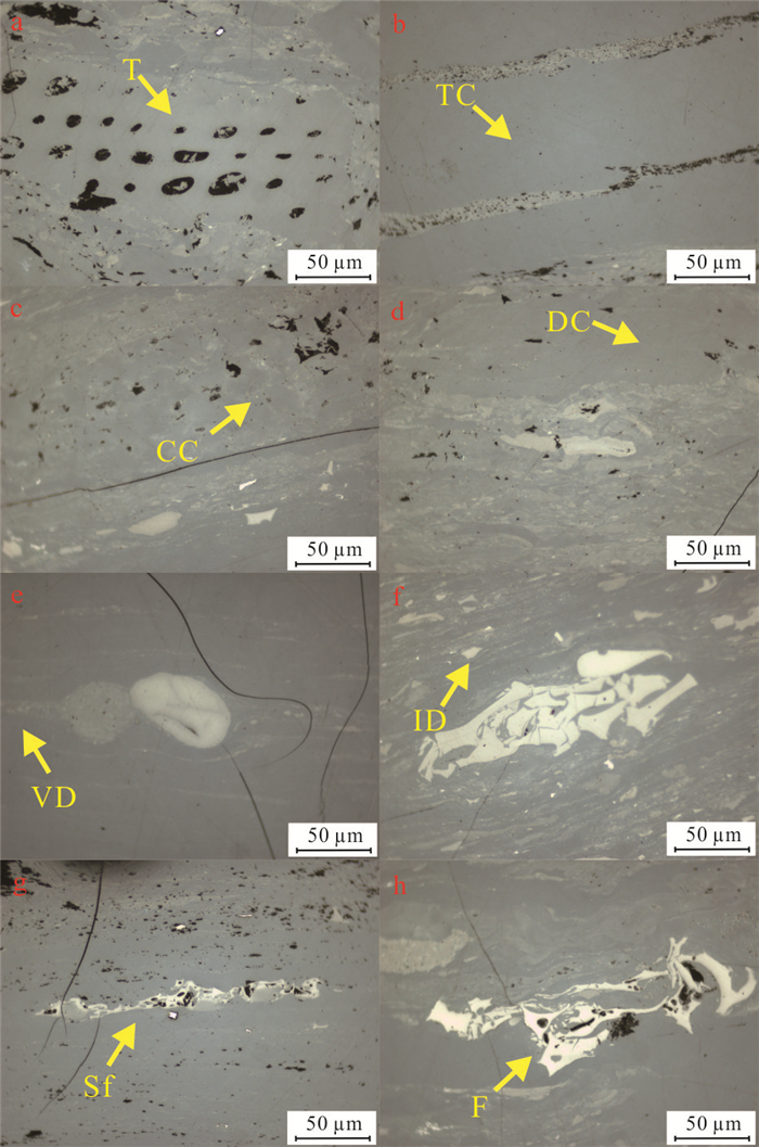
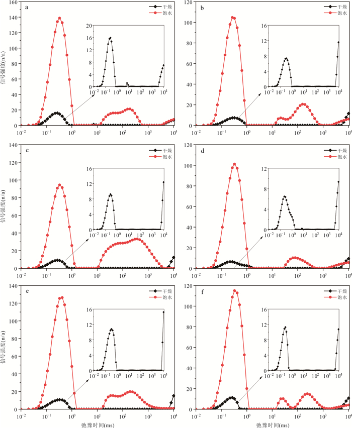
At present, the deep coalbed gas resources in the Suide area are at the early stage of exploration. Clarifying the accumulation and enrichment mechanisms of coalbed gas in this region is therefore of great significance for the efficient development of deep coalbed gas. This study focuses on the No. 8 coal seam of the Benxi Formation from Well Suide 1H. Using organic petrology and rock physics approaches, the differences in reservoir properties between this well and adjacent areas, as well as the controlling factors of depositional environment, pore structure, and gas occurrence characteristics, were systematically analyzed and discussed. The results show that: (1) the coal-forming peat in the study area was mainly derived from wet-forest and open-water marshes; (2) micropores are the dominant pore type, and ash content is the primary controlling factor for micropore development in the coal reservoirs; (3) the No. 8 coal seam of the Benxi Formation exhibits a relatively high gas content, with desorbed gas accounting for the major component of the total gas content; (4) the coal reservoirs in the study area are characterized by high-quality coal, high gas content, gentle structure, and continuous deposition, which together favor coalbed gas enrichment and accumulation. This study clarifies the reservoir and accumulation characteristics of the No. 8 coal seam from Well Suide 1H and provides valuable insights for the exploration and development of deep coal reservoirs.
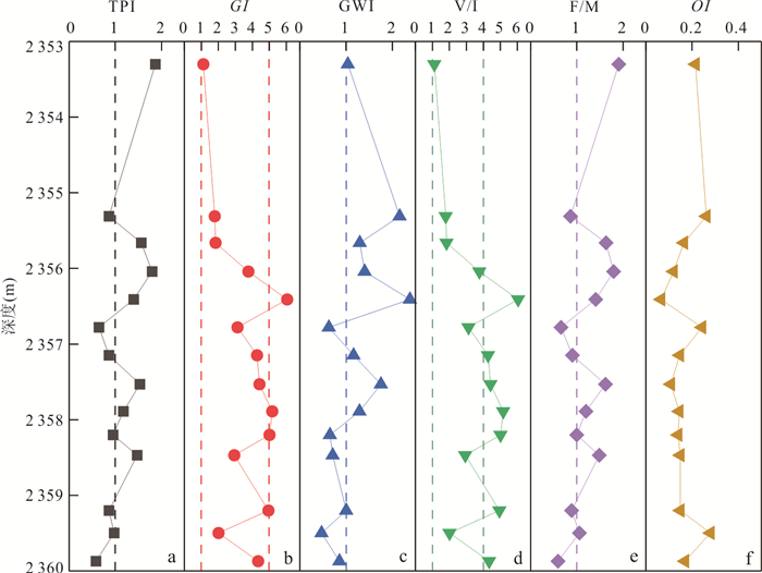
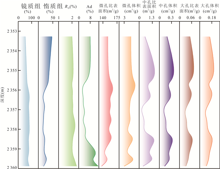
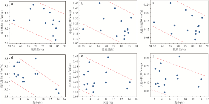
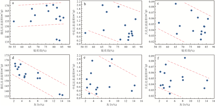
At present, the deep coalbed gas resources in the Suide area are at the early stage of exploration. Clarifying the accumulation and enrichment mechanisms of coalbed gas in this region is therefore of great significance for the efficient development of deep coalbed gas. This study focuses on the No. 8 coal seam of the Benxi Formation from Well Suide 1H. Using organic petrology and rock physics approaches, the differences in reservoir properties between this well and adjacent areas, as well as the controlling factors of depositional environment, pore structure, and gas occurrence characteristics, were systematically analyzed and discussed. The results show that: (1) the coal-forming peat in the study area was mainly derived from wet-forest and open-water marshes; (2) micropores are the dominant pore type, and ash content is the primary controlling factor for micropore development in the coal reservoirs; (3) the No. 8 coal seam of the Benxi Formation exhibits a relatively high gas content, with desorbed gas accounting for the major component of the total gas content; (4) the coal reservoirs in the study area are characterized by high-quality coal, high gas content, gentle structure, and continuous deposition, which together favor coalbed gas enrichment and accumulation. This study clarifies the reservoir and accumulation characteristics of the No. 8 coal seam from Well Suide 1H and provides valuable insights for the exploration and development of deep coal reservoirs.
2026, 51(1): 303-316.
doi: 10.3799/dqkx.2025.308
Abstract:
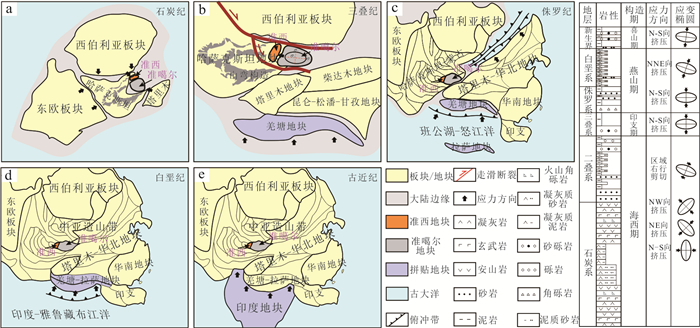
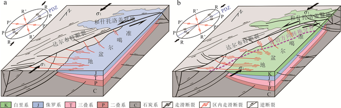
The western Junggar Basin (WJB) has undergone multi-stage tectonic evolution. However, there are still uncertainties regarding the deformation timing, reactivation dynamics, and reservoir-controlling effect of complex faults within the WJB, which restricts oil and gas evaluation and exploration efforts. In this paper, it clarified the development characteristics and reservoir-controlling mechanisms of faults at different stages through integrated structural analysis of intra-basin seismic data and basin-margin field outcrops. The research shows that the WJB has mainly undergone four stages of deformation, each controlled by differential dynamic settings. During the Hercynian, multi-directional plate collisions and compressions generated multi-episode thrust-nappe faults, including N-striking brittle-ductile, NW-striking ductile-brittle, and NE-striking brittle faults. During the Indosinian, thrust-transpressional faults developed in the WJB, driven by the counterclockwise rotation of the Junggar Block and EW-directed compression, with basin-margin dextral transpressional faults and near EW-striking conjugate shear faults formed. During the Yanshanian, the NNE-directed subduction of the Bangong-Nujiang Ocean and the subsequent Lhasa Block collision drove left-lateral strike-slip shearing of the Darbut Fault Zone, and its Riedel shears derived NW-striking and E-striking dextral secondary strike-slip faults. During the Himalayan, the rapid uplift of the North Tianshan Mountains, driven by the India-Eurasia continental collision, triggered the rapid southward tilting of the WJB, generating extensional normal faults within the WJB. In terms of hydrocarbon geological significance, Hercynian thrust-nappe faults were later intensely filled with hydrothermal fluids, forming boundaries that seal oil and gas in deep formations, and basic traps such as faulted anticlines and fault blocks developed concurrently. The Indosinian "fault-fault" migration system transported oil and gas from source rock areas to the Carboniferous, forming two types of paleo-oil reservoirs in the Carboniferous, namely weathered crust reservoirs and interior reservoirs, and developing composite traps concurrently.Yanshanian reticular faults dominated ultra-long-distance westward oil and gas migration, and differential strike-slip movement promoted the migration and accumulation of some oil and gas into the overlying Jurassic-Cretaceous strata. Himalayan normal faults channeled deep oil and gas upward to adjust and accumulate in the Neogene, with the concurrent formation of structural-stratigraphic traps. Multi-stage faults regulated differential hydrocarbon accumulation through reservoir modification, vertical-horizontal migration, and paleo-reservoir adjustment. The vertically ordered superimposition of multiple oil-bearing intervals forms a stereoscopic exploration framework, providing theoretical support for hydrocarbon exploration breakthroughs in the WJB.
The western Junggar Basin (WJB) has undergone multi-stage tectonic evolution. However, there are still uncertainties regarding the deformation timing, reactivation dynamics, and reservoir-controlling effect of complex faults within the WJB, which restricts oil and gas evaluation and exploration efforts. In this paper, it clarified the development characteristics and reservoir-controlling mechanisms of faults at different stages through integrated structural analysis of intra-basin seismic data and basin-margin field outcrops. The research shows that the WJB has mainly undergone four stages of deformation, each controlled by differential dynamic settings. During the Hercynian, multi-directional plate collisions and compressions generated multi-episode thrust-nappe faults, including N-striking brittle-ductile, NW-striking ductile-brittle, and NE-striking brittle faults. During the Indosinian, thrust-transpressional faults developed in the WJB, driven by the counterclockwise rotation of the Junggar Block and EW-directed compression, with basin-margin dextral transpressional faults and near EW-striking conjugate shear faults formed. During the Yanshanian, the NNE-directed subduction of the Bangong-Nujiang Ocean and the subsequent Lhasa Block collision drove left-lateral strike-slip shearing of the Darbut Fault Zone, and its Riedel shears derived NW-striking and E-striking dextral secondary strike-slip faults. During the Himalayan, the rapid uplift of the North Tianshan Mountains, driven by the India-Eurasia continental collision, triggered the rapid southward tilting of the WJB, generating extensional normal faults within the WJB. In terms of hydrocarbon geological significance, Hercynian thrust-nappe faults were later intensely filled with hydrothermal fluids, forming boundaries that seal oil and gas in deep formations, and basic traps such as faulted anticlines and fault blocks developed concurrently. The Indosinian "fault-fault" migration system transported oil and gas from source rock areas to the Carboniferous, forming two types of paleo-oil reservoirs in the Carboniferous, namely weathered crust reservoirs and interior reservoirs, and developing composite traps concurrently.Yanshanian reticular faults dominated ultra-long-distance westward oil and gas migration, and differential strike-slip movement promoted the migration and accumulation of some oil and gas into the overlying Jurassic-Cretaceous strata. Himalayan normal faults channeled deep oil and gas upward to adjust and accumulate in the Neogene, with the concurrent formation of structural-stratigraphic traps. Multi-stage faults regulated differential hydrocarbon accumulation through reservoir modification, vertical-horizontal migration, and paleo-reservoir adjustment. The vertically ordered superimposition of multiple oil-bearing intervals forms a stereoscopic exploration framework, providing theoretical support for hydrocarbon exploration breakthroughs in the WJB.
2026, 51(1): 317-328.
doi: 10.3799/dqkx.2025.295
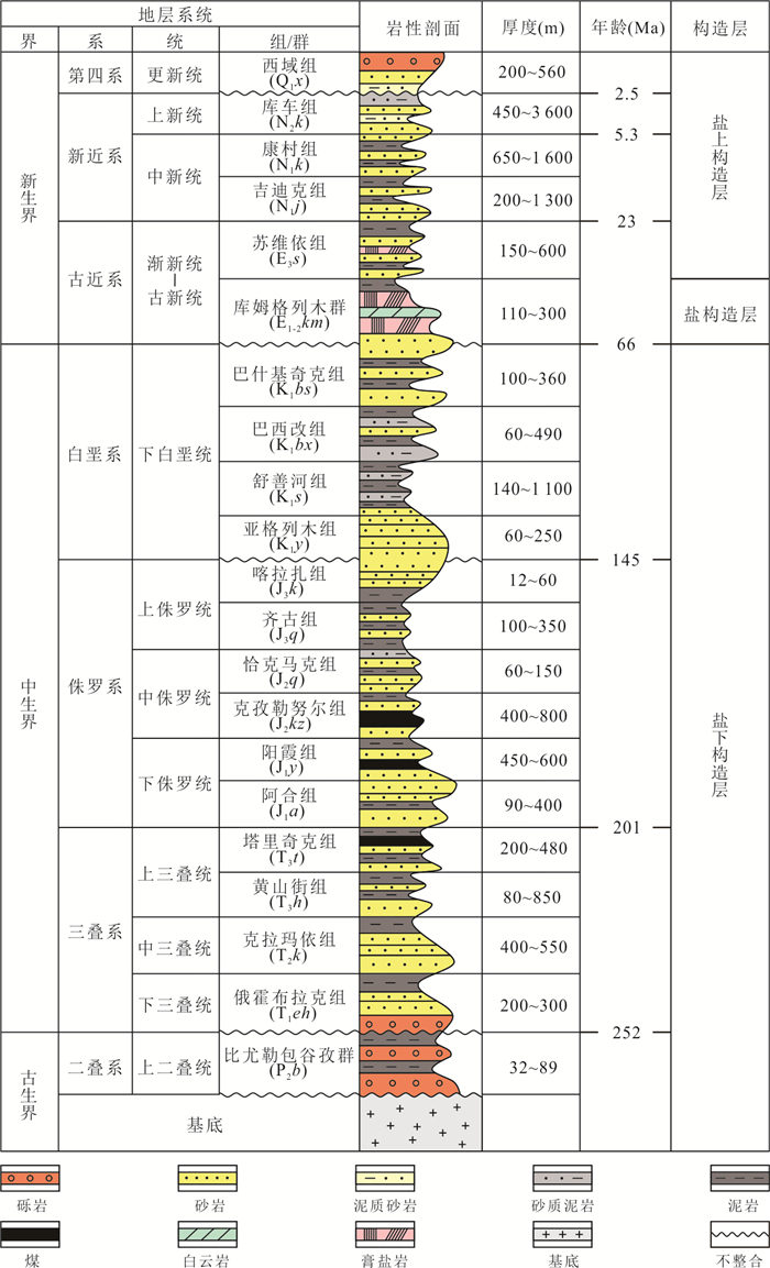
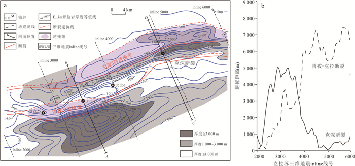
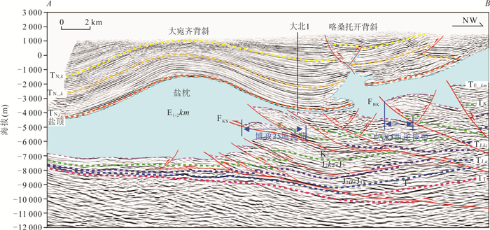
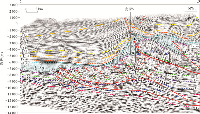
Abstract:
Overthrust belt is of significant importance for hydrocarbon exploration. To elucidate the characteristics and formation mechanisms of the subsalt overthrust belts in the middle Kelasu structural belt, Kuqa Depression, it conducted detailed seismic profile interpretation combined with discrete element numerical modeling. The results reveal the development of two major subsalt overthrust belts, Bozi 25 and Keshen 5 West, in the middle Kelasu structural belt, and demonstrate that their spatial distribution is closely coupled with the Paleogene salt-lake distribution and pre-existing salt diapiric structures. The frontal uplift separating the two salt lakes, where abrupt variations in gypsum-salt layer thickness occur, acts as a stress concentration zone which facilitates the preferential propagation of large-scale overthrust structures. Moreover, the progressive growth of salt diapirs provides additional accommodation space for the development of these large-scale overthrust systems. These findings highlight the footwalls of overthrust structures as key targets for future hydrocarbon exploration and for identifying or re-evaluating Bashijiqike Formation traps within the Kelasu structural belt.
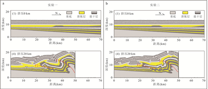
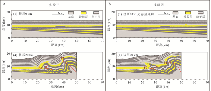
Overthrust belt is of significant importance for hydrocarbon exploration. To elucidate the characteristics and formation mechanisms of the subsalt overthrust belts in the middle Kelasu structural belt, Kuqa Depression, it conducted detailed seismic profile interpretation combined with discrete element numerical modeling. The results reveal the development of two major subsalt overthrust belts, Bozi 25 and Keshen 5 West, in the middle Kelasu structural belt, and demonstrate that their spatial distribution is closely coupled with the Paleogene salt-lake distribution and pre-existing salt diapiric structures. The frontal uplift separating the two salt lakes, where abrupt variations in gypsum-salt layer thickness occur, acts as a stress concentration zone which facilitates the preferential propagation of large-scale overthrust structures. Moreover, the progressive growth of salt diapirs provides additional accommodation space for the development of these large-scale overthrust systems. These findings highlight the footwalls of overthrust structures as key targets for future hydrocarbon exploration and for identifying or re-evaluating Bashijiqike Formation traps within the Kelasu structural belt.
2026, 51(1): 329-344.
doi: 10.3799/dqkx.2025.235
Abstract:
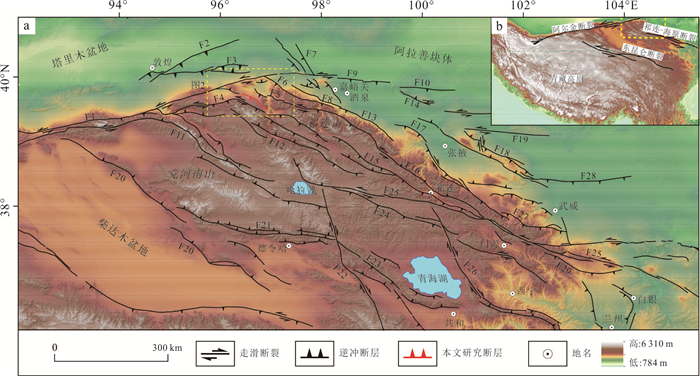
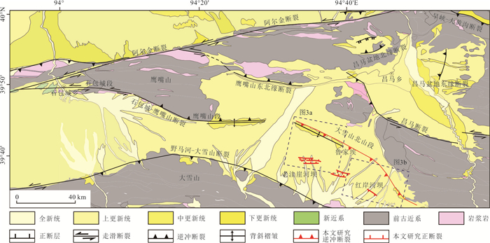
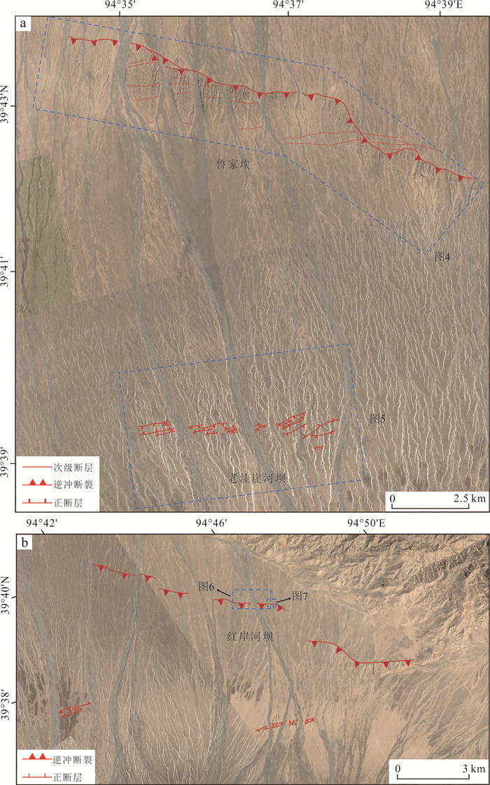
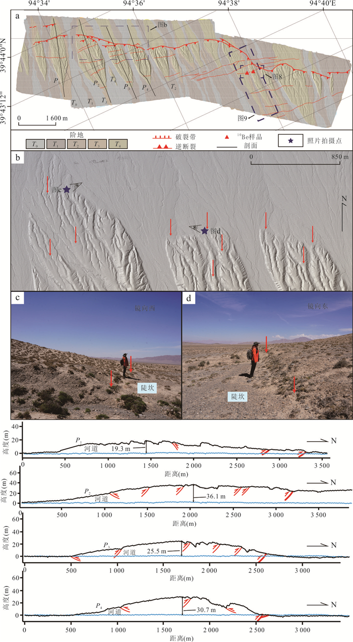
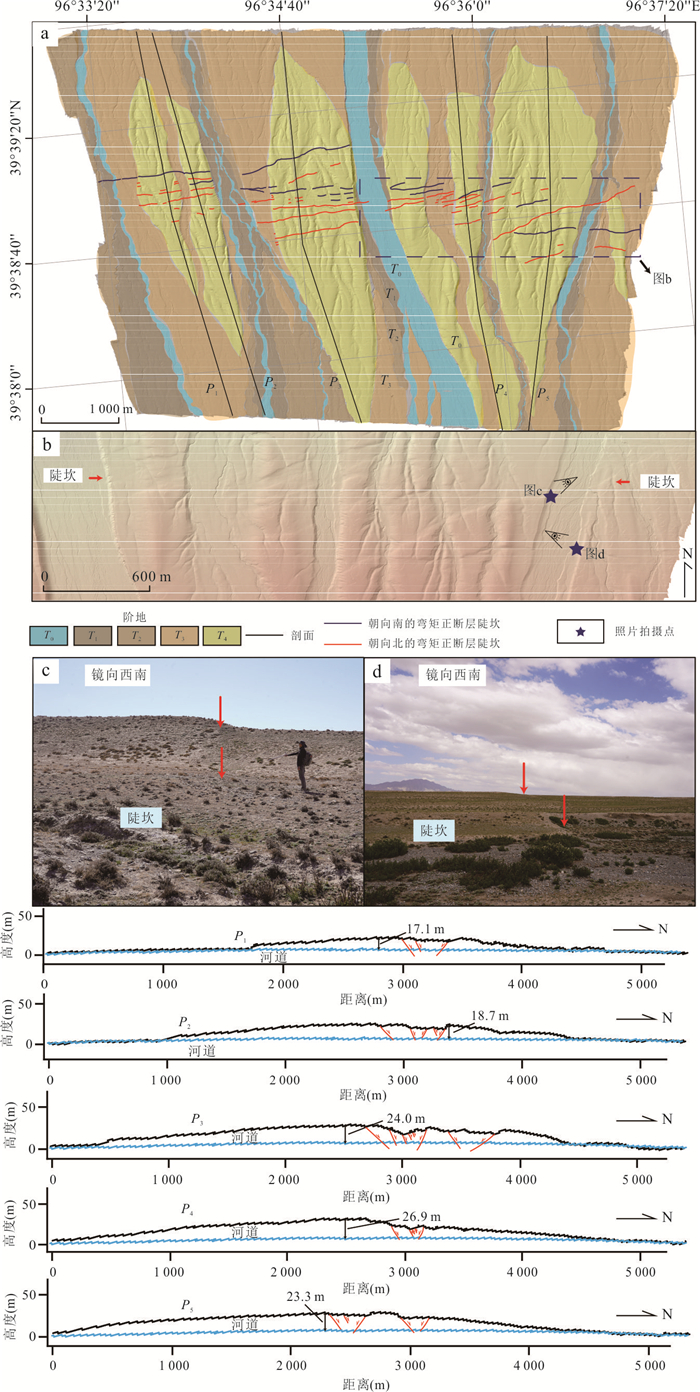
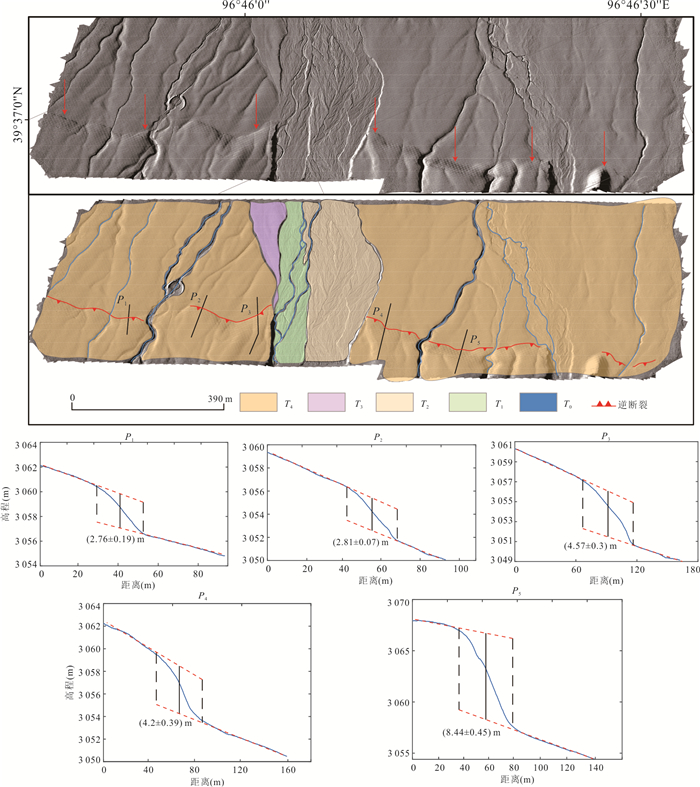
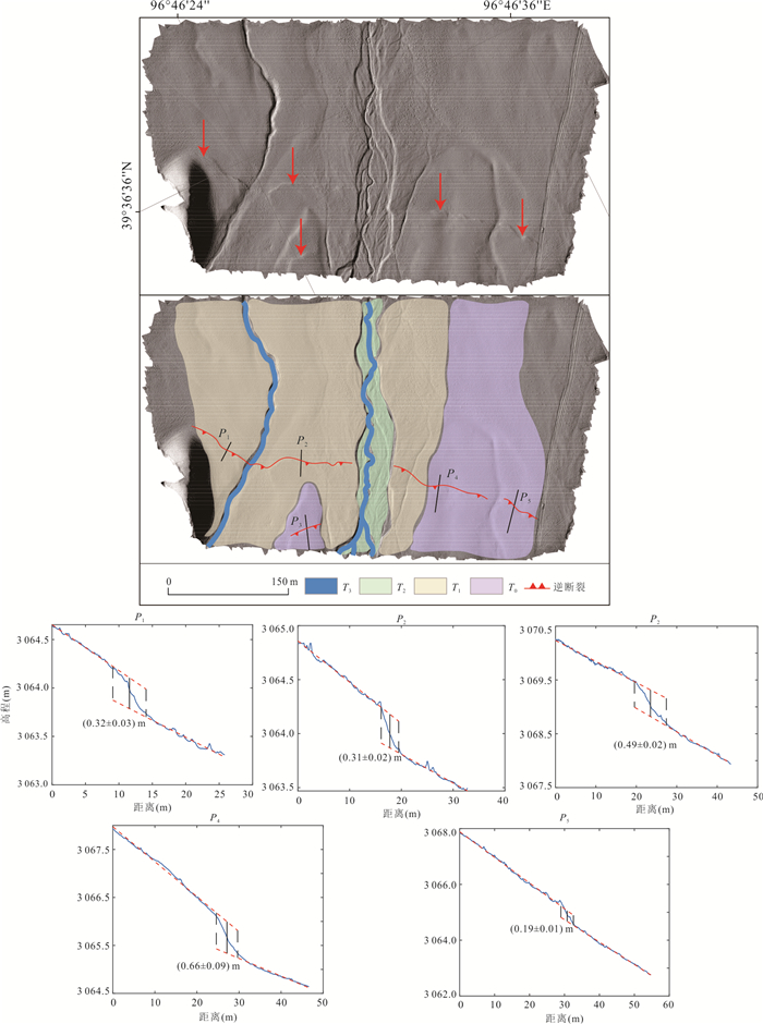
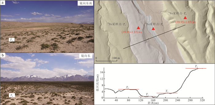
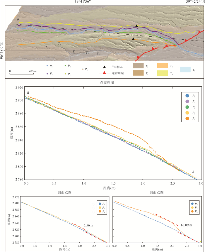
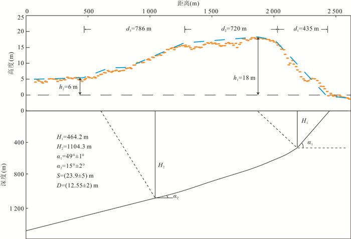
Located at the northern edge of the Qinghai-Tibet Plateau and the western end of the Qilian Mountains, the Shibaocheng-Changma Basin and its surrounding areas are characterized by numerous active tectonic features and intense tectonic activity. Among these, the Shibaocheng-Yingzuishan Fault Zone, as the largest reverse fault-fold belt in the basin, exhibits complex tectonic deformation patterns and distinct fault dislocation landforms. This region is an ideal area for studying basin-mountain tectonic deformation and its deep-shallow tectonic relationships, as well as for understanding the tectonic conversion relationships between different faults and crustal shortening patterns. This study employs high-precision unmanned aerial vehicle (UAV) Structure-from-Motion (SfM) photogrammetry techniques, combined with field survey results, to conduct a detailed interpretation of faulted landforms. It analyzes the latest activity characteristics and tectonic deformation patterns of the Daxue Shan Bei Shan Fault within the eastern segment of the Yingzuishan Fault. It also employs cosmogenic nuclide dating methods to age-date key faulted landforms, and further calculates the Late Quaternary deformation rates through analyses of the deformation patterns and deformation amounts of multi-level terraces and their corresponding landform surfaces. The research results indicate that the Daxue Shan Bei Shan Fault consists of two rows of faults. The thrusting action of the front-edge fault has formed multiple reverse fault-fold belts within the basin, while the rear-edge fault has developed bend-moment normal faults associated with fold, forming a typical reverse fault-normal fold combination. Fault activity caused the front-edge fault (Lujiaai segment) terraces T3 and T4 to experience vertical displacements of (6.56±0.34) m and (16.09±1.13) m, respectively. Based on terrace age calculations, the vertical slip rate of this fault segment is approximately (0.15±0.01) mm/a, with a horizontal shortening rate of approximately (0.12±0.02) mm/a and the overall thrust rate is approximately (0.19±0.03) mm/a. The deep slip surface extends southward to Daxue Shan Fault at a depth of approximately (2.7±0.5) km, forming a typical thin-skinned reverse fault-fold deformation zone, which is the result of the fault system's forward-extending compression and expansion into the basin interior.
Located at the northern edge of the Qinghai-Tibet Plateau and the western end of the Qilian Mountains, the Shibaocheng-Changma Basin and its surrounding areas are characterized by numerous active tectonic features and intense tectonic activity. Among these, the Shibaocheng-Yingzuishan Fault Zone, as the largest reverse fault-fold belt in the basin, exhibits complex tectonic deformation patterns and distinct fault dislocation landforms. This region is an ideal area for studying basin-mountain tectonic deformation and its deep-shallow tectonic relationships, as well as for understanding the tectonic conversion relationships between different faults and crustal shortening patterns. This study employs high-precision unmanned aerial vehicle (UAV) Structure-from-Motion (SfM) photogrammetry techniques, combined with field survey results, to conduct a detailed interpretation of faulted landforms. It analyzes the latest activity characteristics and tectonic deformation patterns of the Daxue Shan Bei Shan Fault within the eastern segment of the Yingzuishan Fault. It also employs cosmogenic nuclide dating methods to age-date key faulted landforms, and further calculates the Late Quaternary deformation rates through analyses of the deformation patterns and deformation amounts of multi-level terraces and their corresponding landform surfaces. The research results indicate that the Daxue Shan Bei Shan Fault consists of two rows of faults. The thrusting action of the front-edge fault has formed multiple reverse fault-fold belts within the basin, while the rear-edge fault has developed bend-moment normal faults associated with fold, forming a typical reverse fault-normal fold combination. Fault activity caused the front-edge fault (Lujiaai segment) terraces T3 and T4 to experience vertical displacements of (6.56±0.34) m and (16.09±1.13) m, respectively. Based on terrace age calculations, the vertical slip rate of this fault segment is approximately (0.15±0.01) mm/a, with a horizontal shortening rate of approximately (0.12±0.02) mm/a and the overall thrust rate is approximately (0.19±0.03) mm/a. The deep slip surface extends southward to Daxue Shan Fault at a depth of approximately (2.7±0.5) km, forming a typical thin-skinned reverse fault-fold deformation zone, which is the result of the fault system's forward-extending compression and expansion into the basin interior.
2026, 51(1): 345-360.
doi: 10.3799/dqkx.2025.240
Abstract:
Fractures serve as the primary storage space and seepage pathways for CO2 geological storage, directly influencing storage efficiency and long-term containment security. This study employed UAV oblique photogrammetry to construct a discrete fracture network (DFN) model of a fractured sandstone reservoir within the Ordos Basin. Subsequently, a fluid-solid coupling numerical model for CO2-water two-phase flow was established using the multiphysics simulation software COMSOL Multiphysics, explicitly accounting for the matrix-bedding-fracture system. Key findings reveal that CO2 preferentially migrates along high-permeability bedding planes and fractures. Horizontal bedding, combined with low-dip, low-connectivity natural fractures, impedes vertical seepage, thereby reducing the risk of CO2 escape into the caprock. The fracture network accelerates pressure transmission, inducing significant displacement responses. The initial rate of displacement increase was found to be 6.2 times higher than that observed in the matrix model. Consequently, accurately representing the multi-porosity system encompassing the matrix, bedding, and fractures is crucial for assessing the stability of CO2 geological storage.
Fractures serve as the primary storage space and seepage pathways for CO2 geological storage, directly influencing storage efficiency and long-term containment security. This study employed UAV oblique photogrammetry to construct a discrete fracture network (DFN) model of a fractured sandstone reservoir within the Ordos Basin. Subsequently, a fluid-solid coupling numerical model for CO2-water two-phase flow was established using the multiphysics simulation software COMSOL Multiphysics, explicitly accounting for the matrix-bedding-fracture system. Key findings reveal that CO2 preferentially migrates along high-permeability bedding planes and fractures. Horizontal bedding, combined with low-dip, low-connectivity natural fractures, impedes vertical seepage, thereby reducing the risk of CO2 escape into the caprock. The fracture network accelerates pressure transmission, inducing significant displacement responses. The initial rate of displacement increase was found to be 6.2 times higher than that observed in the matrix model. Consequently, accurately representing the multi-porosity system encompassing the matrix, bedding, and fractures is crucial for assessing the stability of CO2 geological storage.