2026 Vol. 51, No. 5
Display Method:
2026, 51(5): 1599-1618.
doi: 10.3799/dqkx.2026.137
 PDF 4827KB
Abstract:
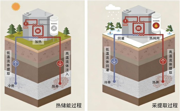
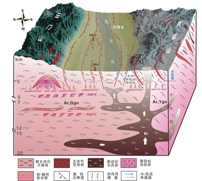
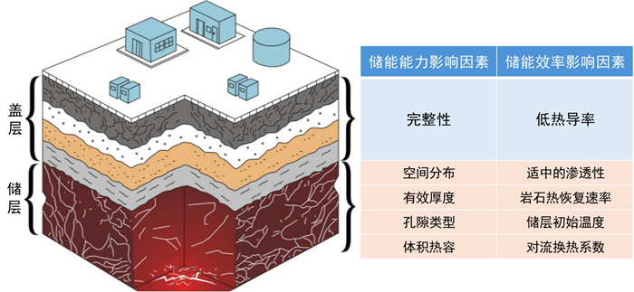
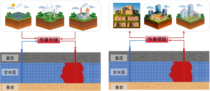
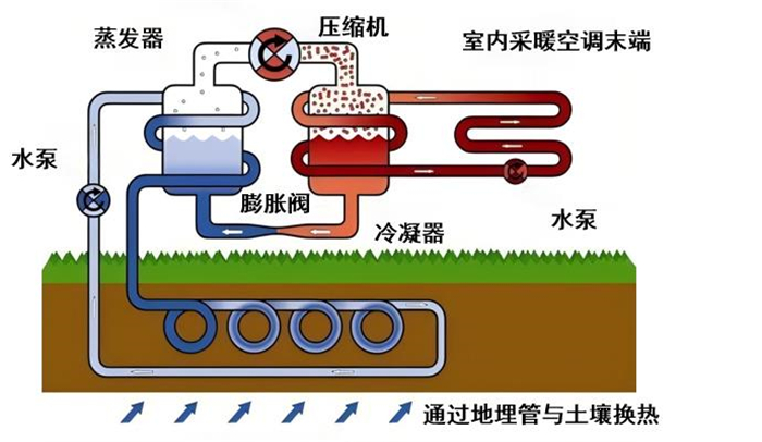
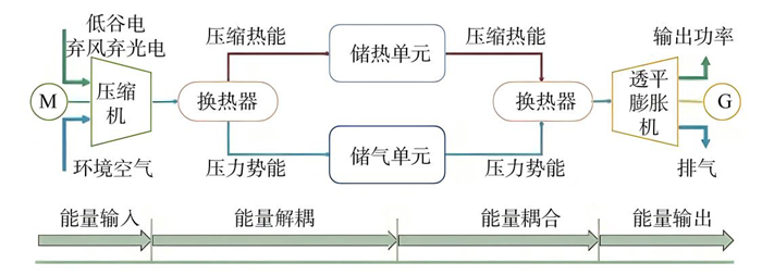
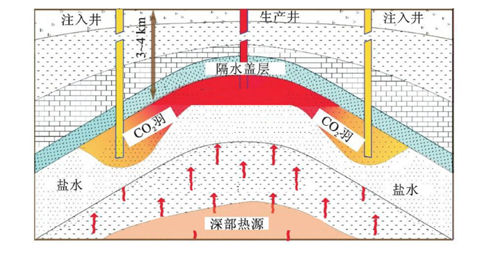
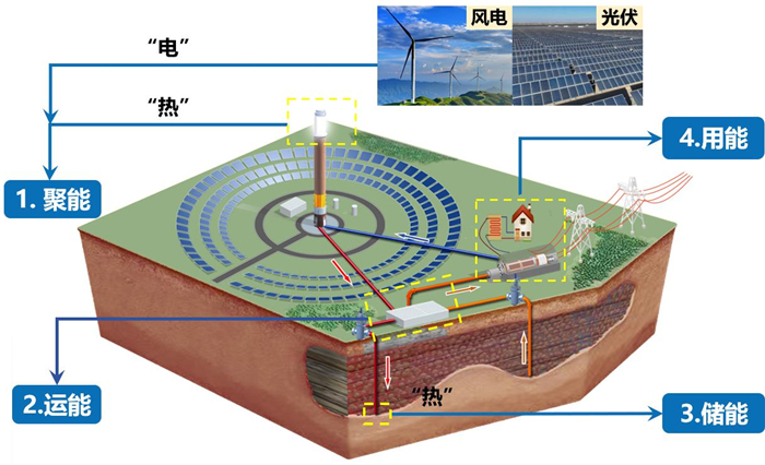
Against the background of low-carbon energy transition, the inherent intermittency and volatility of wind and photovoltaic power pose significant challenges to grid integration and utilization efficiency, which has become a key bottleneck constraining the optimization and upgrading of the energy structure. Energy storage technology, as a core means of achieving inter-temporal energy regulation, provides crucial technical support to address this challenge. As an emerging long-duration, large-scale energy storage technology, deep geothermal energy storage has gradually become a research focus and a frontier direction in the field of renewable energy, owing to its prominent advantages such as substantial scalability, high economical efficiency, wide application scenarios, and strong system resilience. In this paper it systematically elaborates on the technological background and core strengths of deep geothermal energy storage, and conducts an in-depth analysis of the classification characteristics of deep geothermal systems, the geological structures for energy storage, as well as the key factors influencing storage capacity and efficiency. It presents a detailed review of mainstream technical pathways, including hydrothermal reservoir heat storage, geotechnical energy storage, compressed air energy storage, and CO2 plume geothermal systems, covering their working principles, current status of engineering applications, and key technological advances. The paper comprehensively examines the critical issues currently faced by deep geothermal energy storage in areas such as site exploration, efficiency regulation, and environmental safety risk prevention. Finally, future development recommendations are proposed from two dimensions: the construction of a multi-energy complementary energy system, and the enhancement of technological innovation and industrial development systems. The aim is to provide theoretical reference and technical support for the large‑scale application and sustainable development of deep geothermal energy storage technology, thereby contributing to the achievement of China's "dual-carbon" goals and energy security strategy.
Against the background of low-carbon energy transition, the inherent intermittency and volatility of wind and photovoltaic power pose significant challenges to grid integration and utilization efficiency, which has become a key bottleneck constraining the optimization and upgrading of the energy structure. Energy storage technology, as a core means of achieving inter-temporal energy regulation, provides crucial technical support to address this challenge. As an emerging long-duration, large-scale energy storage technology, deep geothermal energy storage has gradually become a research focus and a frontier direction in the field of renewable energy, owing to its prominent advantages such as substantial scalability, high economical efficiency, wide application scenarios, and strong system resilience. In this paper it systematically elaborates on the technological background and core strengths of deep geothermal energy storage, and conducts an in-depth analysis of the classification characteristics of deep geothermal systems, the geological structures for energy storage, as well as the key factors influencing storage capacity and efficiency. It presents a detailed review of mainstream technical pathways, including hydrothermal reservoir heat storage, geotechnical energy storage, compressed air energy storage, and CO2 plume geothermal systems, covering their working principles, current status of engineering applications, and key technological advances. The paper comprehensively examines the critical issues currently faced by deep geothermal energy storage in areas such as site exploration, efficiency regulation, and environmental safety risk prevention. Finally, future development recommendations are proposed from two dimensions: the construction of a multi-energy complementary energy system, and the enhancement of technological innovation and industrial development systems. The aim is to provide theoretical reference and technical support for the large‑scale application and sustainable development of deep geothermal energy storage technology, thereby contributing to the achievement of China's "dual-carbon" goals and energy security strategy.
2026, 51(5): 1619-1635.
doi: 10.3799/dqkx.2026.169
Abstract:
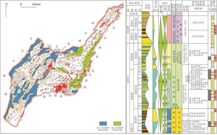
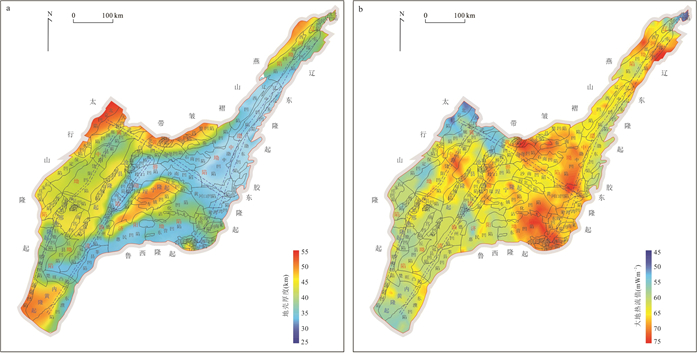
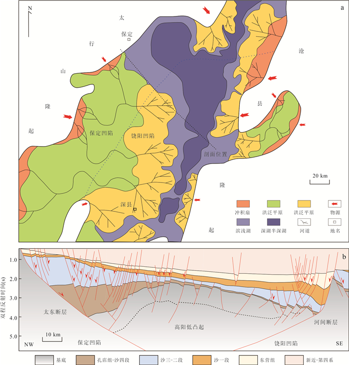
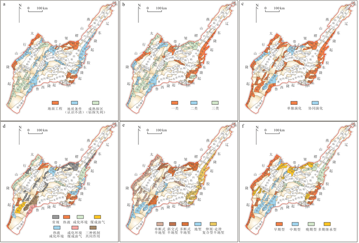
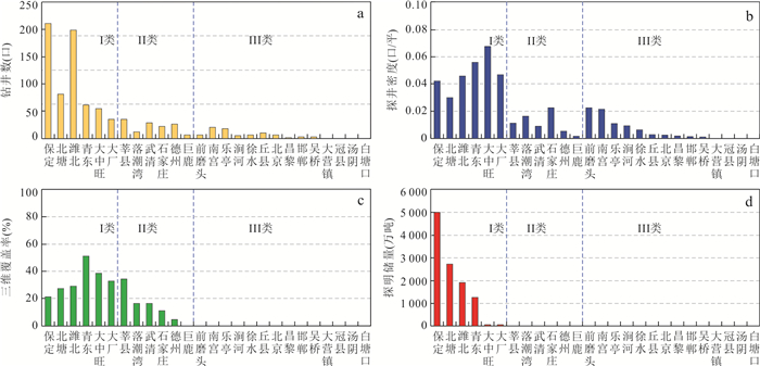
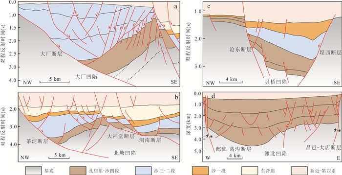
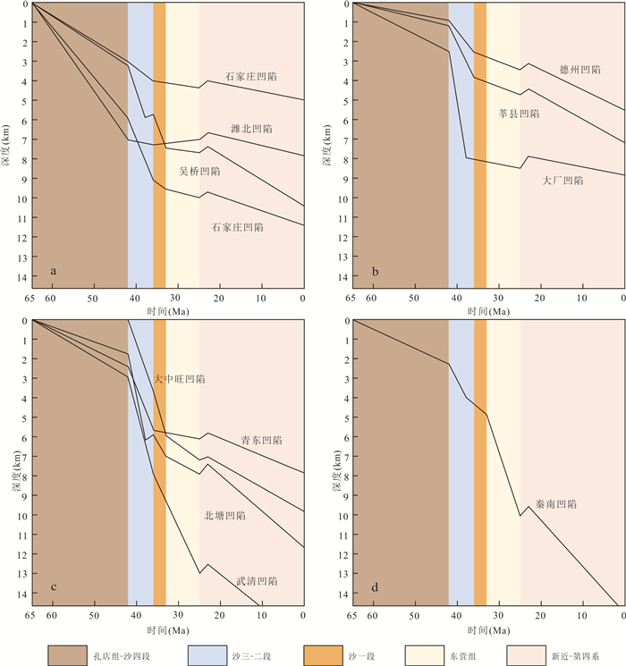
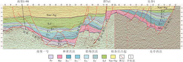
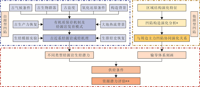
To address the pressure of reserve replacement in the oil-rich sags of the Bohai Bay basin and promote the rapid conversion of oil and gas resources in new areas, this study systematically reviews the exploration and research status of various low exploration degree depressions, and analyzes their special geological conditions, type distribution, and exploration significance by combining geological analysis with multi-dimensional classification evaluation methods. The results indicate that low exploration depressions possess advantages such as high-quality hydrocarbon source rocks in salinized lake basins, improved reservoir-forming conditions due to deep faults and abnormal heat flow, and co-evolution with oil-rich sags. Based on multiple dimensions including subjective reasons, implementation effects, structural types, subsidence types, hydrocarbon generation mechanisms, and co-evolution relationships with major depressions, various types can be classified, with distinct planar zoning characteristics. It is concluded that low exploration degree depressions have good exploration prospects, and there are significant differences in geological and exploration difficulties among different types of depressions. Through multi-dimensional classification evaluation and precise deployment, it is expected to achieve oil and gas breakthroughs by revealing advantageous reservoir-forming conditions, thereby promoting effective succession of oil and gas resources in the basin.
To address the pressure of reserve replacement in the oil-rich sags of the Bohai Bay basin and promote the rapid conversion of oil and gas resources in new areas, this study systematically reviews the exploration and research status of various low exploration degree depressions, and analyzes their special geological conditions, type distribution, and exploration significance by combining geological analysis with multi-dimensional classification evaluation methods. The results indicate that low exploration depressions possess advantages such as high-quality hydrocarbon source rocks in salinized lake basins, improved reservoir-forming conditions due to deep faults and abnormal heat flow, and co-evolution with oil-rich sags. Based on multiple dimensions including subjective reasons, implementation effects, structural types, subsidence types, hydrocarbon generation mechanisms, and co-evolution relationships with major depressions, various types can be classified, with distinct planar zoning characteristics. It is concluded that low exploration degree depressions have good exploration prospects, and there are significant differences in geological and exploration difficulties among different types of depressions. Through multi-dimensional classification evaluation and precise deployment, it is expected to achieve oil and gas breakthroughs by revealing advantageous reservoir-forming conditions, thereby promoting effective succession of oil and gas resources in the basin.
2026, 51(5): 1636-1651.
doi: 10.3799/dqkx.2026.083
Abstract:
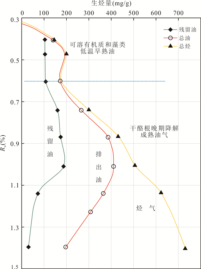
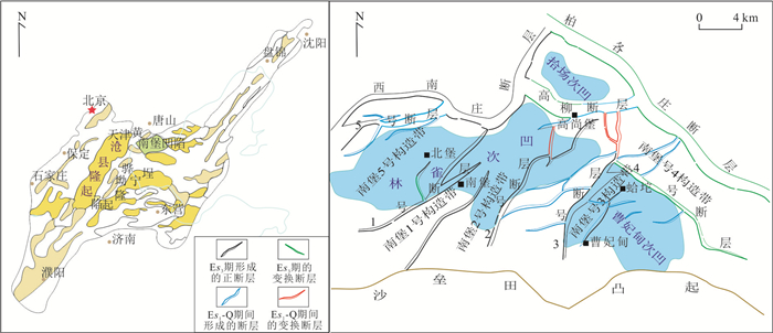
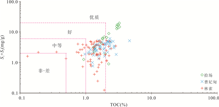
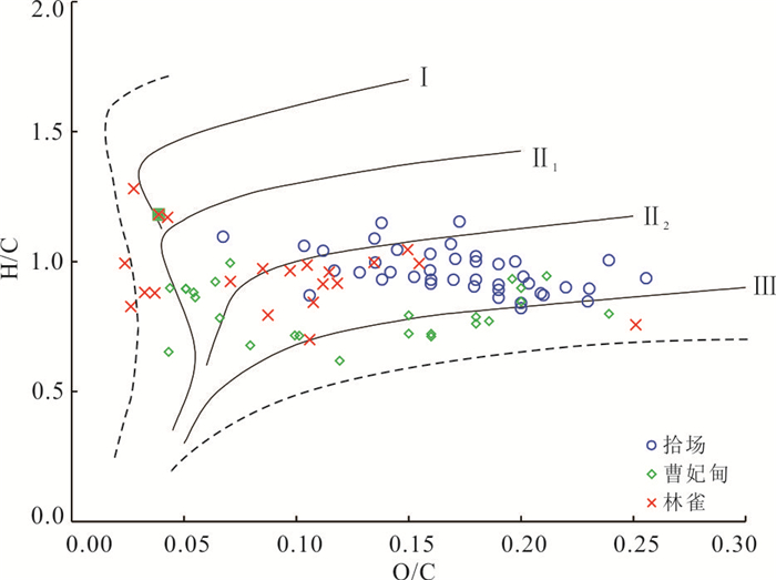
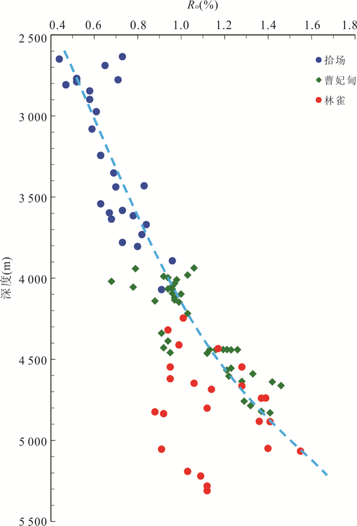
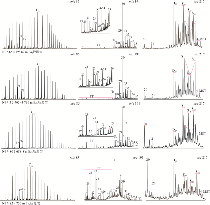
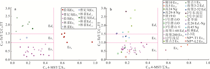
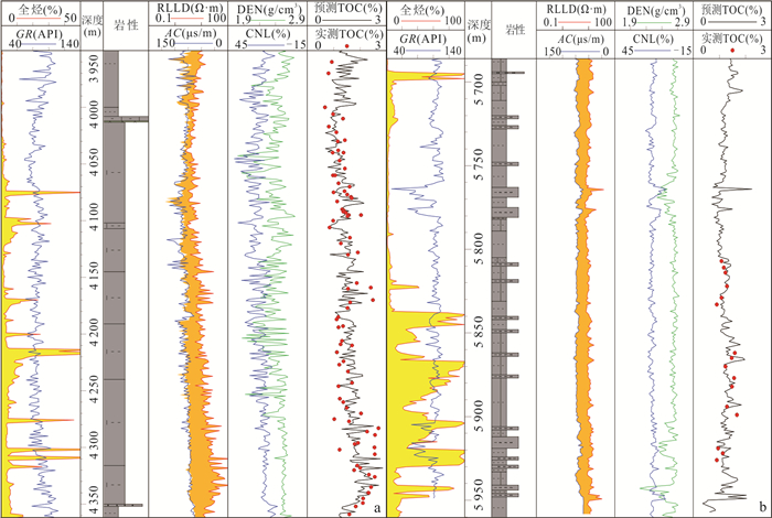
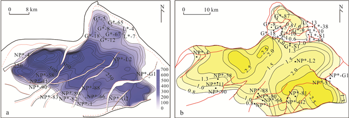
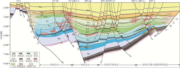
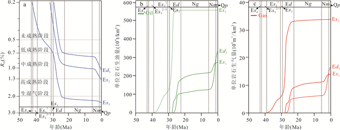
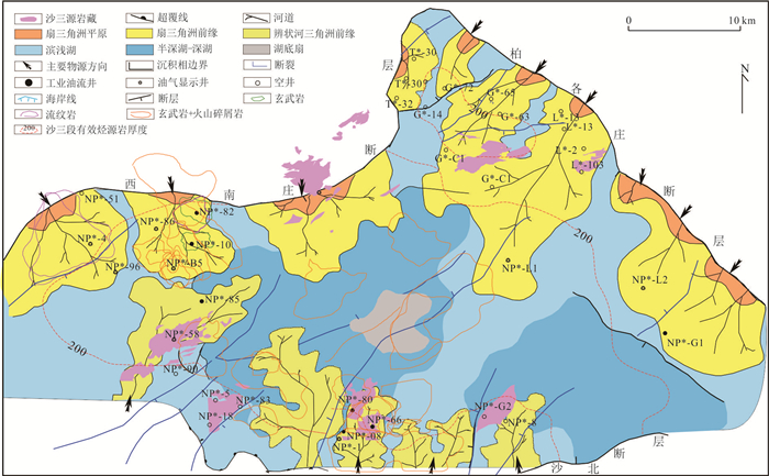
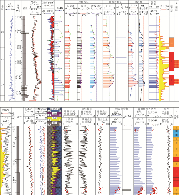
To investigate the geochemical characteristics and hydrocarbon accumulation contribution of high-quality source rocks in the Sha-3 Member of the mature exploration area in the Nanpu sag, Bohai Bay basin, a typical superimposed basin, this study evaluates the hydrocarbon generation potential of the source rocks based on data including total organic carbon (TOC), pyrolysis, organic elemental analysis, and vitrinite reflectance (Ro). Molecular geochemistry of the source rocks is characterized using GC-MS analysis of source rocks and crude oils, combined with hydrocarbon generation potential evaluation results. The quantitative oil-source correlation is established using biomarker parameter cross-plots to determine the accumulation contribution. Resource potential is assessed by integrating source rock logging evaluation, seismic prediction, and basin modeling. Research indicates that the Es3 source rock in the Nanpu sag possesses high organic matter abundance, classifying it as a set of high-quality source rocks. The organic matter type is predominantly Type Ⅱ1. Currently, this source rock suite is in the mature to high-mature stage, primarily generating light oil and condensate. Using biomarker parameter cross-plots, specifically C24 tetracyclic terpane/C26 tricyclic terpane versus C30 4-methylsterane/C29 regular sterane, effectively distinguishes the four sets of main source rocks in the Nanpu sag. Oil-source correlation demonstrates that the oil in the deep Es3 and Paleozoic buried hills surrounding the Linque and Caofeidian sub-sags is primarily sourced from the Es3 source rocks. Favorable exploration targets include deep volcaniclastic rock reservoirs south of the Gaoliu fault within the Caofeidian and Linque sub-sags, deep structural-lithological and lithological reservoirs in the Es1 and Es3 members within the trough zones, and Ordovician residual hill buried hills and Cambrian internal buried hills. Additionally, the Es3 source rocks in the southern slope zone have moderate burial depth and thermal evolution, and contain developed deep-water saline lacustrine carbonate laminae with high movable oil content, making this zone a favorable play for shale oil exploration.
To investigate the geochemical characteristics and hydrocarbon accumulation contribution of high-quality source rocks in the Sha-3 Member of the mature exploration area in the Nanpu sag, Bohai Bay basin, a typical superimposed basin, this study evaluates the hydrocarbon generation potential of the source rocks based on data including total organic carbon (TOC), pyrolysis, organic elemental analysis, and vitrinite reflectance (Ro). Molecular geochemistry of the source rocks is characterized using GC-MS analysis of source rocks and crude oils, combined with hydrocarbon generation potential evaluation results. The quantitative oil-source correlation is established using biomarker parameter cross-plots to determine the accumulation contribution. Resource potential is assessed by integrating source rock logging evaluation, seismic prediction, and basin modeling. Research indicates that the Es3 source rock in the Nanpu sag possesses high organic matter abundance, classifying it as a set of high-quality source rocks. The organic matter type is predominantly Type Ⅱ1. Currently, this source rock suite is in the mature to high-mature stage, primarily generating light oil and condensate. Using biomarker parameter cross-plots, specifically C24 tetracyclic terpane/C26 tricyclic terpane versus C30 4-methylsterane/C29 regular sterane, effectively distinguishes the four sets of main source rocks in the Nanpu sag. Oil-source correlation demonstrates that the oil in the deep Es3 and Paleozoic buried hills surrounding the Linque and Caofeidian sub-sags is primarily sourced from the Es3 source rocks. Favorable exploration targets include deep volcaniclastic rock reservoirs south of the Gaoliu fault within the Caofeidian and Linque sub-sags, deep structural-lithological and lithological reservoirs in the Es1 and Es3 members within the trough zones, and Ordovician residual hill buried hills and Cambrian internal buried hills. Additionally, the Es3 source rocks in the southern slope zone have moderate burial depth and thermal evolution, and contain developed deep-water saline lacustrine carbonate laminae with high movable oil content, making this zone a favorable play for shale oil exploration.
2026, 51(5): 1652-1666.
doi: 10.3799/dqkx.2026.104
Abstract:
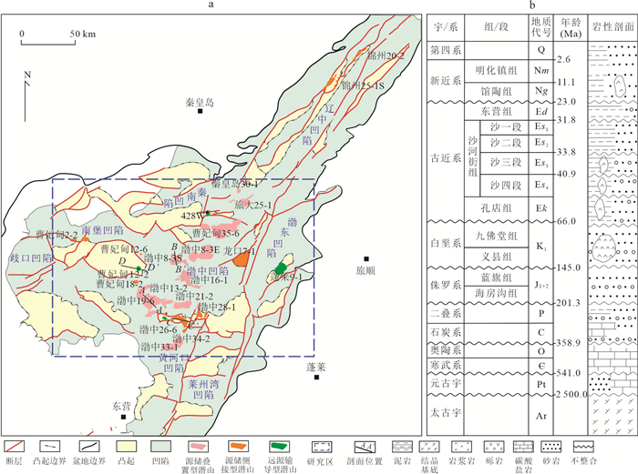
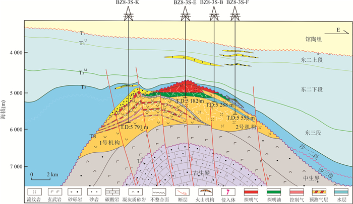
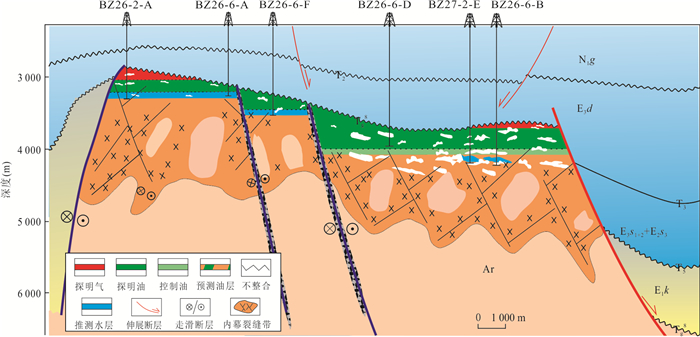
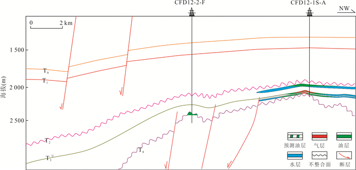
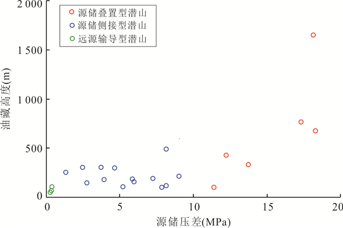
The central-southern Bohai Sea area develops diverse types of buried hills with substantial petroleum exploration potential. However, the scale of hydrocarbon accumulation varies significantly among different buried hills, and the key controlling factors remain to be clarified. The source-reservoir configuration is the core element controlling efficient hydrocarbon accumulation and enrichment scale. This study systematically analyzes the source-reservoir configuration characteristics of buried hills in different structural positions within the study area and their control on accumulation scales by integrating seismic, geological, and geochemical data. Based on the spatial coupling relationship between buried hills and source rocks, migration pathways, and reservoir development characteristics, the buried hills are classified into three types: source-reservoir superimposed, source-reservoir lateral-connected, and distal-source transported types. The results indicate that source-reservoir superimposed buried hills, typically located in sag areas, exhibit the highest accumulation efficiency due to their proximity to source rocks, large source-reservoir pressure differential, and superior preservation conditions characterized by "source-caprock integration", securing their optimal configuration for discovering giant oil and gas fields. Source-reservoir lateral-connected buried hills, often situated in slope zones/low uplift, feature multiple source rock contributions, three-dimensional migration pathways, and favorable reservoir-seal assemblages, facilitating the formation of medium to large oil and gas fields. In contrast, distal-source transported buried hills, predominantly found in uplift areas, despite their shallow burial depths, present high exploration risks due to long migration distances from source rocks, small source-reservoir pressure differentials, low migration efficiency, and poor preservation conditions. This study establishes a buried hill classification and evaluation model based on source-reservoir configuration, identifying source-reservoir superimposed and lateral-connected buried hills in sag to slope zones as favorable targets for subsequent exploration. The findings provide an important theoretical basis and decision-making guidance for the exploration deployment of large-scale buried hill oil and gas fields in sag areas of "Super basins".
The central-southern Bohai Sea area develops diverse types of buried hills with substantial petroleum exploration potential. However, the scale of hydrocarbon accumulation varies significantly among different buried hills, and the key controlling factors remain to be clarified. The source-reservoir configuration is the core element controlling efficient hydrocarbon accumulation and enrichment scale. This study systematically analyzes the source-reservoir configuration characteristics of buried hills in different structural positions within the study area and their control on accumulation scales by integrating seismic, geological, and geochemical data. Based on the spatial coupling relationship between buried hills and source rocks, migration pathways, and reservoir development characteristics, the buried hills are classified into three types: source-reservoir superimposed, source-reservoir lateral-connected, and distal-source transported types. The results indicate that source-reservoir superimposed buried hills, typically located in sag areas, exhibit the highest accumulation efficiency due to their proximity to source rocks, large source-reservoir pressure differential, and superior preservation conditions characterized by "source-caprock integration", securing their optimal configuration for discovering giant oil and gas fields. Source-reservoir lateral-connected buried hills, often situated in slope zones/low uplift, feature multiple source rock contributions, three-dimensional migration pathways, and favorable reservoir-seal assemblages, facilitating the formation of medium to large oil and gas fields. In contrast, distal-source transported buried hills, predominantly found in uplift areas, despite their shallow burial depths, present high exploration risks due to long migration distances from source rocks, small source-reservoir pressure differentials, low migration efficiency, and poor preservation conditions. This study establishes a buried hill classification and evaluation model based on source-reservoir configuration, identifying source-reservoir superimposed and lateral-connected buried hills in sag to slope zones as favorable targets for subsequent exploration. The findings provide an important theoretical basis and decision-making guidance for the exploration deployment of large-scale buried hill oil and gas fields in sag areas of "Super basins".
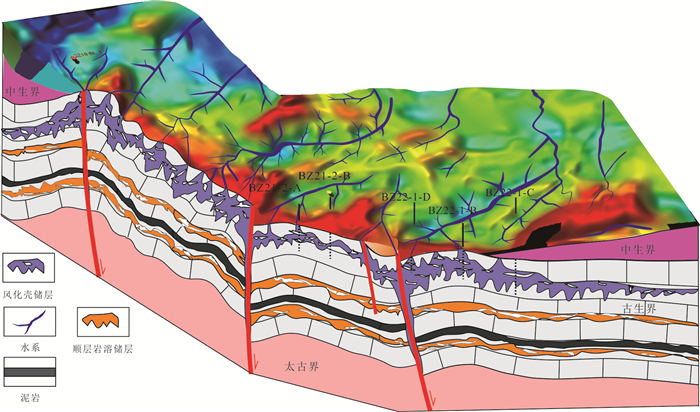
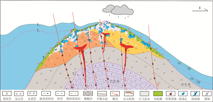
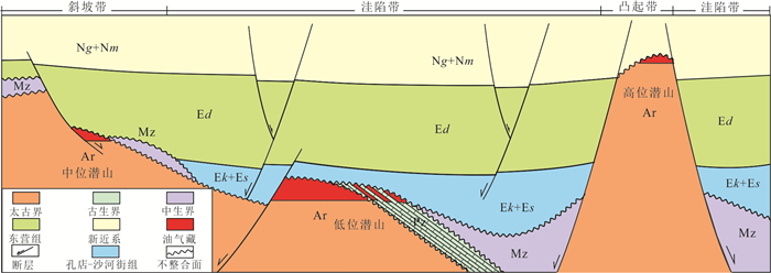
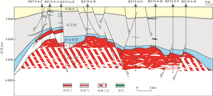
2026, 51(5): 1667-1684.
doi: 10.3799/dqkx.2026.122
Abstract:
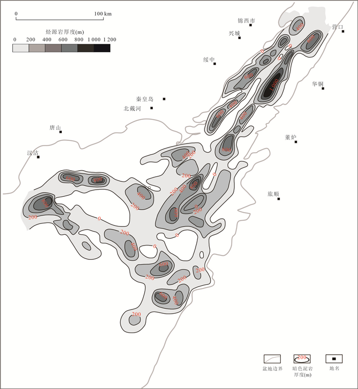
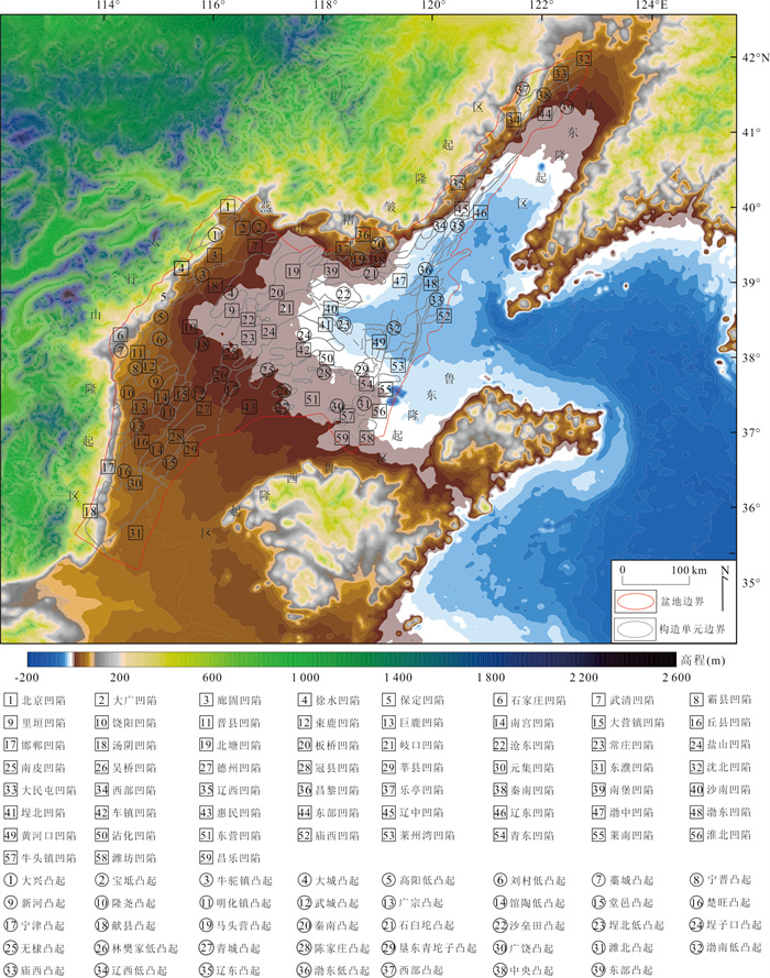
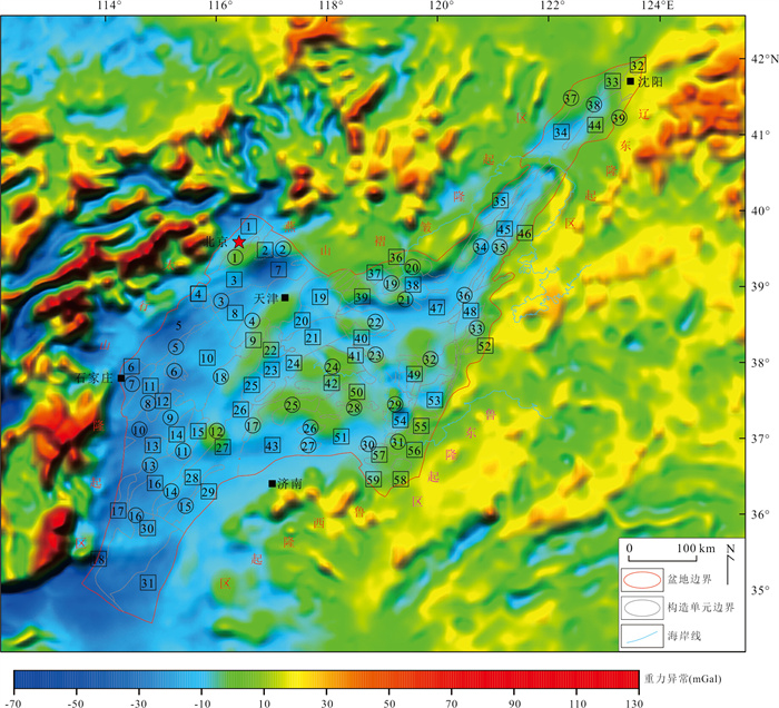
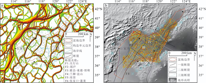
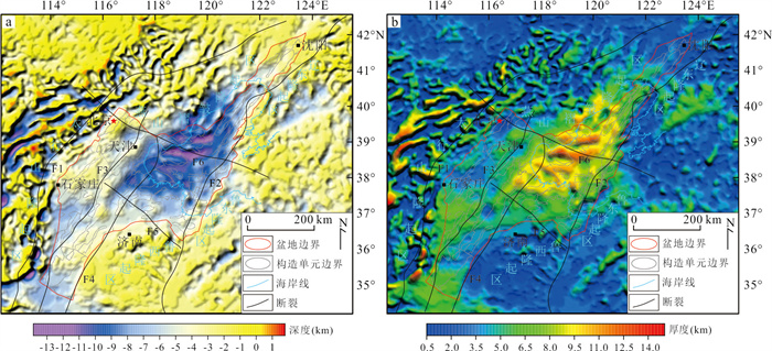
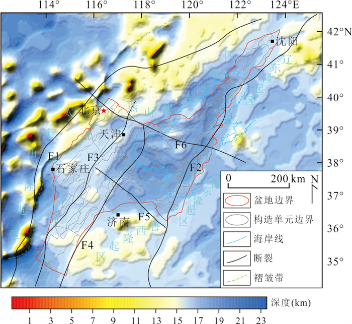
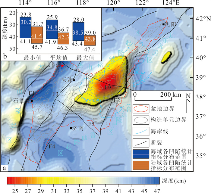
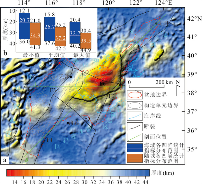
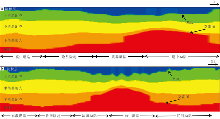
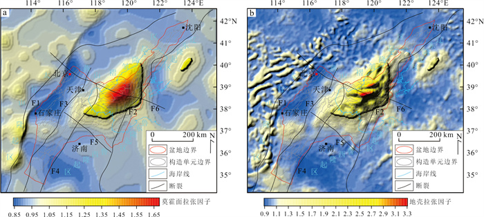
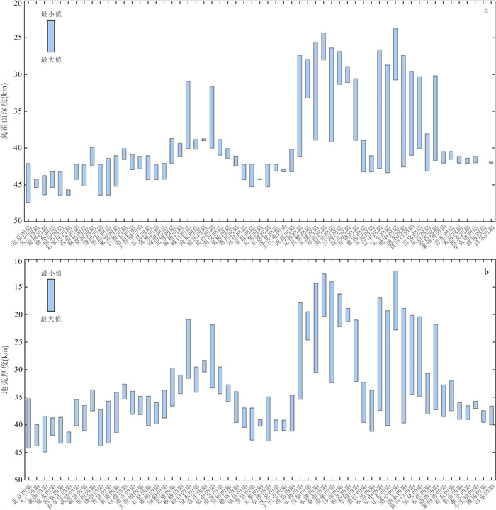
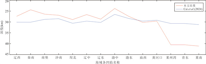
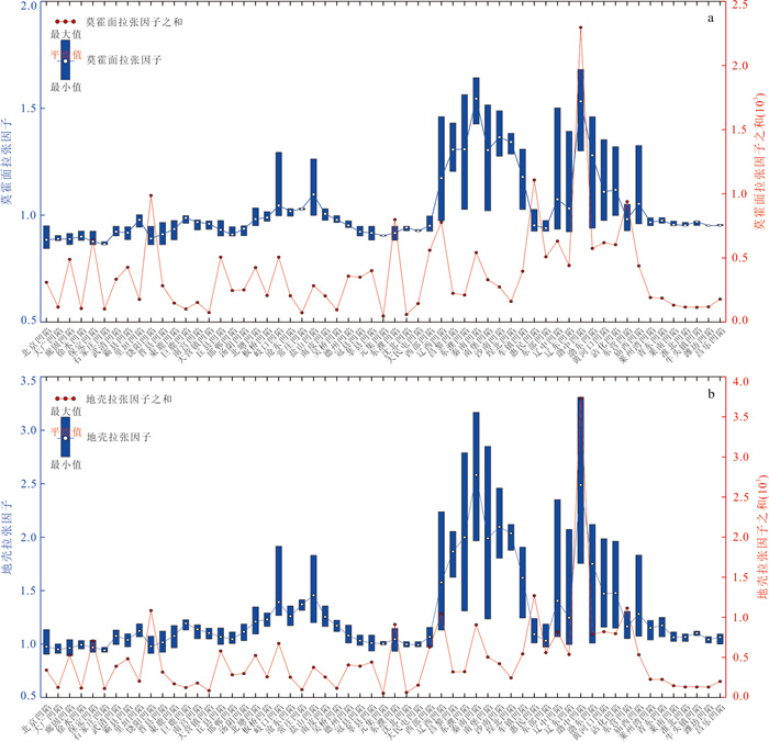
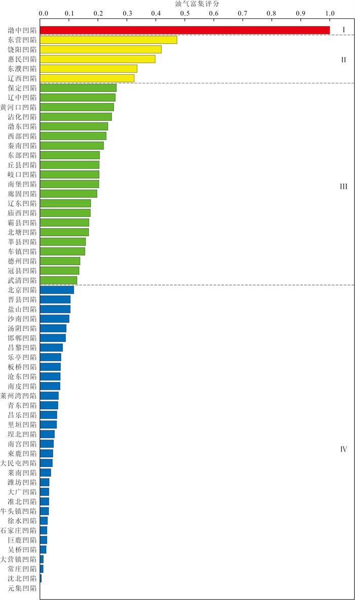
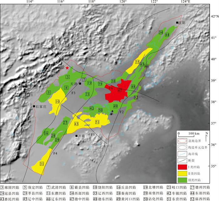
As a Cenozoic intracontinental rift basin superimposed on the Paleozoic North China Craton depression, the Bohai Bay basin is located at the junction center of three major tectonic domains, where its hydrocarbon potential is closely related to the crustal structure. Based on the gravity data of the Bohai Bay basin, this study systematically analyzes the fault system of basin, basement characteristics, and Moho discontinuity distribution, and quantitatively evaluates the oil and gas enrichment potential of 59 sags using Principal Component Analysis (PCA). The results show that the faults of basin are characterized by multi-directional development, hierarchical control, and deep-shallow coupling, with their formation synergistically driven by the dual dynamic sources of "mantle thermal extension and plate boundary strike-slip movement". The Moho discontinuity exhibits a significant mirror response relationship with the basement: the average depth of the Moho in the marine area (33.5 km) is significantly shallower than that in the continental area (42.1 km), and the crystalline crust thickness shows a spatial differentiation feature of "thicker in the continental area (36.7 km) and thinner in the marine area (25.3 km)". As the core area of mantle uplift and crustal stretching-thinning in the basin, the Bozhong sag achieved a comprehensive score of 1.00 for oil and gas enrichment potential, ranking first among all sags. According to the comprehensive enrichment score, the 59 sags were classified into four types of exploration targets. Among them, Type Ⅰ-Ⅲ sags (including 27 sags such as Bozhong, Dongying, Raoyang, and Huimin) are favorable for oil and gas exploration, while Type Ⅳ sags (32 sags) have low exploration value due to weak deep tectonic activity and limited reservoir-forming conditions. The findings of this study not only reveal the correlation mechanism between deep crustal structure and oil-gas enrichment in the Bohai Bay basin but also provide important deep geological basis and technical support for the precise exploration of oil and gas resources in this basin and similar intracontinental rift basins worldwide.
As a Cenozoic intracontinental rift basin superimposed on the Paleozoic North China Craton depression, the Bohai Bay basin is located at the junction center of three major tectonic domains, where its hydrocarbon potential is closely related to the crustal structure. Based on the gravity data of the Bohai Bay basin, this study systematically analyzes the fault system of basin, basement characteristics, and Moho discontinuity distribution, and quantitatively evaluates the oil and gas enrichment potential of 59 sags using Principal Component Analysis (PCA). The results show that the faults of basin are characterized by multi-directional development, hierarchical control, and deep-shallow coupling, with their formation synergistically driven by the dual dynamic sources of "mantle thermal extension and plate boundary strike-slip movement". The Moho discontinuity exhibits a significant mirror response relationship with the basement: the average depth of the Moho in the marine area (33.5 km) is significantly shallower than that in the continental area (42.1 km), and the crystalline crust thickness shows a spatial differentiation feature of "thicker in the continental area (36.7 km) and thinner in the marine area (25.3 km)". As the core area of mantle uplift and crustal stretching-thinning in the basin, the Bozhong sag achieved a comprehensive score of 1.00 for oil and gas enrichment potential, ranking first among all sags. According to the comprehensive enrichment score, the 59 sags were classified into four types of exploration targets. Among them, Type Ⅰ-Ⅲ sags (including 27 sags such as Bozhong, Dongying, Raoyang, and Huimin) are favorable for oil and gas exploration, while Type Ⅳ sags (32 sags) have low exploration value due to weak deep tectonic activity and limited reservoir-forming conditions. The findings of this study not only reveal the correlation mechanism between deep crustal structure and oil-gas enrichment in the Bohai Bay basin but also provide important deep geological basis and technical support for the precise exploration of oil and gas resources in this basin and similar intracontinental rift basins worldwide.
2026, 51(5): 1685-1697.
doi: 10.3799/dqkx.2026.078
Abstract:
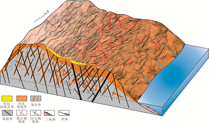
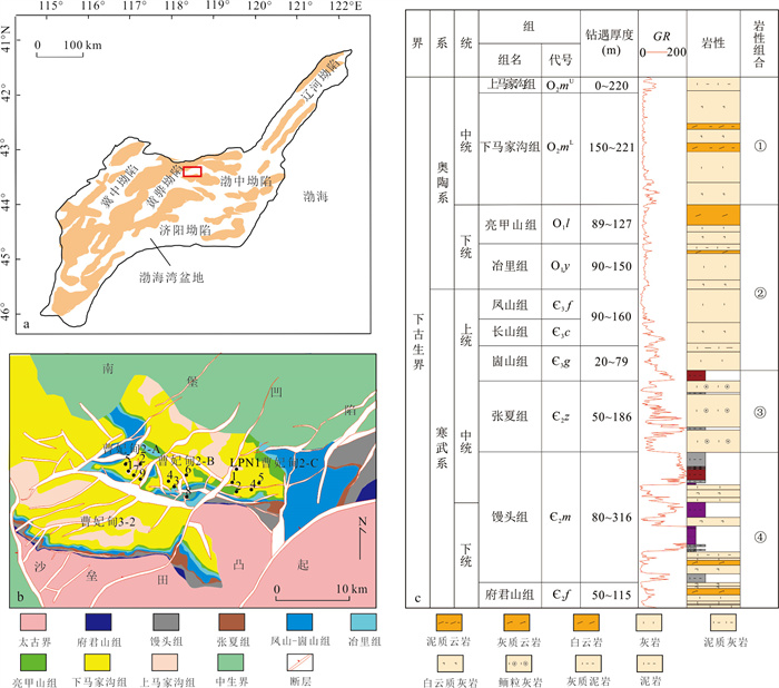
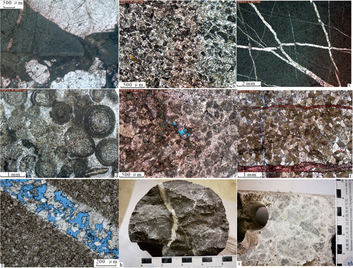
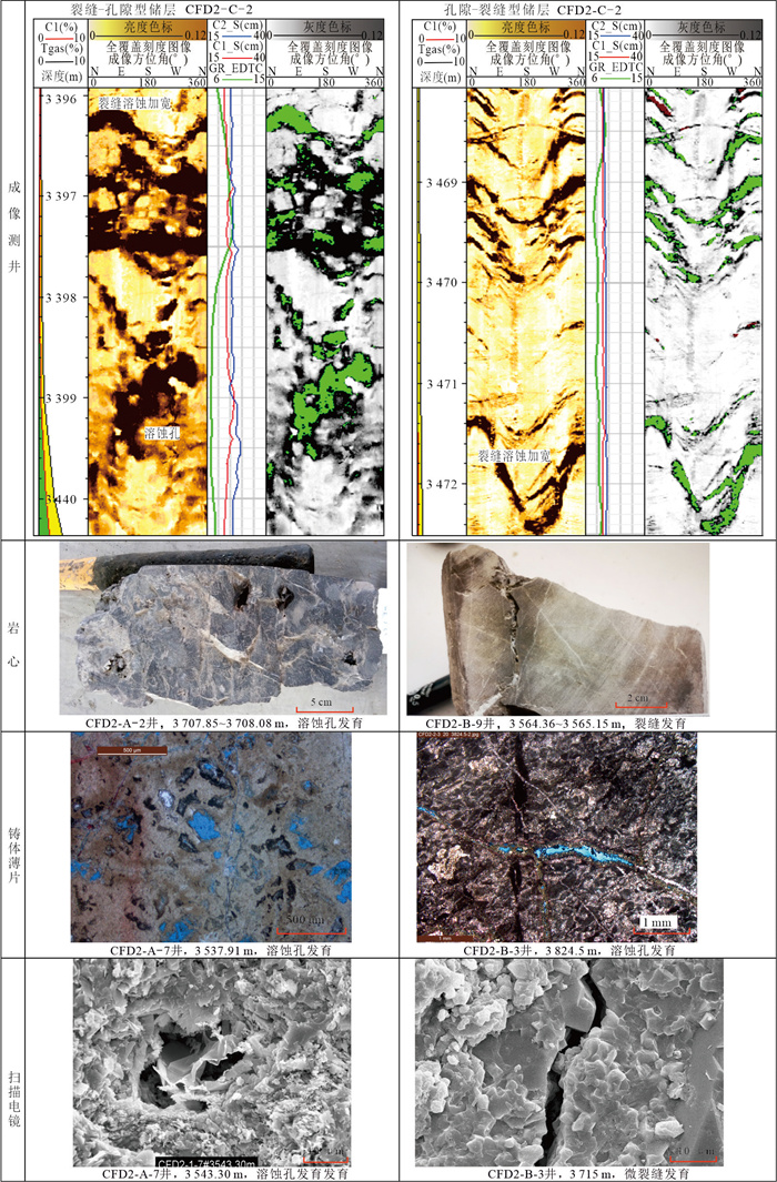
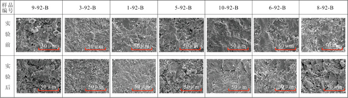
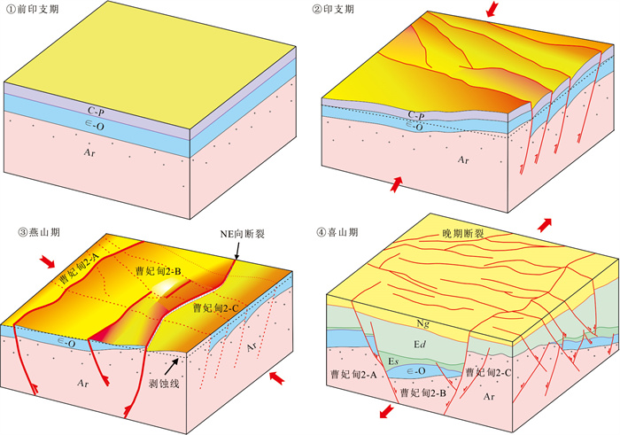
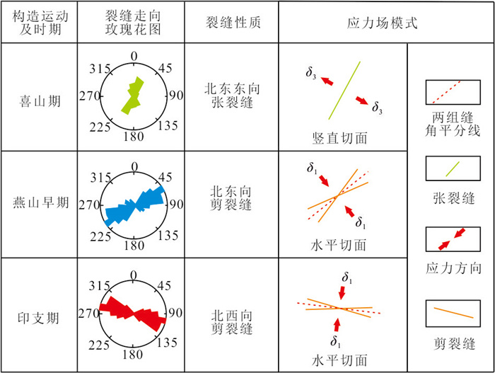
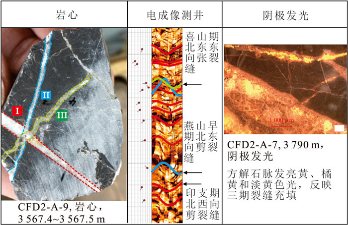
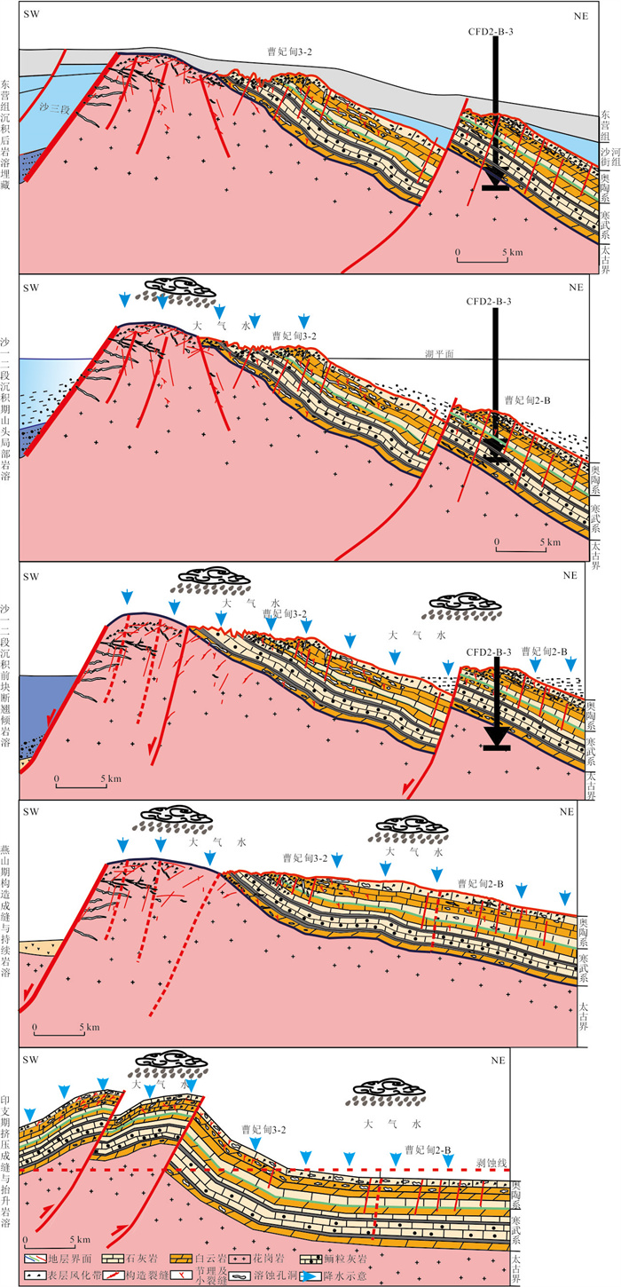
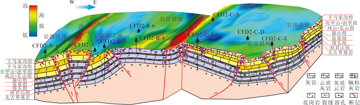
The strong heterogeneity and unclear development mechanism of the Lower Paleozoic buried hill reservoir seriously restrict its exploration effect. In this paper, the characteristics, main controlling factors and distribution rules of the Lower Paleozoic carbonate reservoirs in the slope zone of Nanpu sag were studied by using core, imaging logging and analytical test data. The results show that the study area develops two types of reservoirs: "supergene karst" and "fracture karst". The reservoir space of "supergene karst" reservoir is dominated by small dissolution pores, which are concentrated in the high part of the structure and the top of the buried hill within 100 m. The main reservoir space of the 'fracture-dissolved body' reservoir is fractures, with a wide range of distribution, and the reservoir section is generally more than 150 m. Rock type is the material basis of reservoir development, and limestone and dolomitic limestone are the dominant lithology of karst reservoir. Fracture is the core element of reservoir development, and the fracture network system provides a channel for the dissolution of atmospheric water. Paleogeomorphology is the key condition for reservoir development, and the upper slope is a favorable location for karstification. Therefore, the development mechanism of "lithology-structure-paleogeomorphology" three-element coupling reservoir is established.
The strong heterogeneity and unclear development mechanism of the Lower Paleozoic buried hill reservoir seriously restrict its exploration effect. In this paper, the characteristics, main controlling factors and distribution rules of the Lower Paleozoic carbonate reservoirs in the slope zone of Nanpu sag were studied by using core, imaging logging and analytical test data. The results show that the study area develops two types of reservoirs: "supergene karst" and "fracture karst". The reservoir space of "supergene karst" reservoir is dominated by small dissolution pores, which are concentrated in the high part of the structure and the top of the buried hill within 100 m. The main reservoir space of the 'fracture-dissolved body' reservoir is fractures, with a wide range of distribution, and the reservoir section is generally more than 150 m. Rock type is the material basis of reservoir development, and limestone and dolomitic limestone are the dominant lithology of karst reservoir. Fracture is the core element of reservoir development, and the fracture network system provides a channel for the dissolution of atmospheric water. Paleogeomorphology is the key condition for reservoir development, and the upper slope is a favorable location for karstification. Therefore, the development mechanism of "lithology-structure-paleogeomorphology" three-element coupling reservoir is established.
2026, 51(5): 1698-1720.
doi: 10.3799/dqkx.2026.069
Abstract:
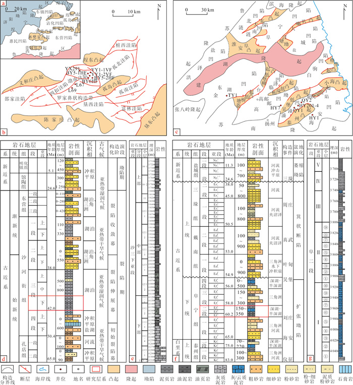
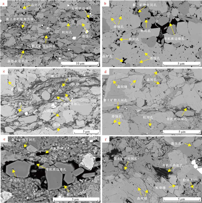
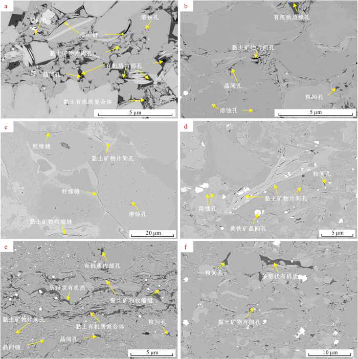
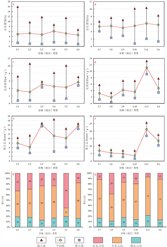
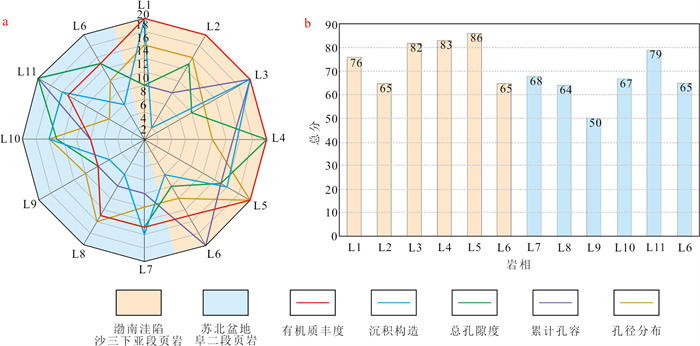
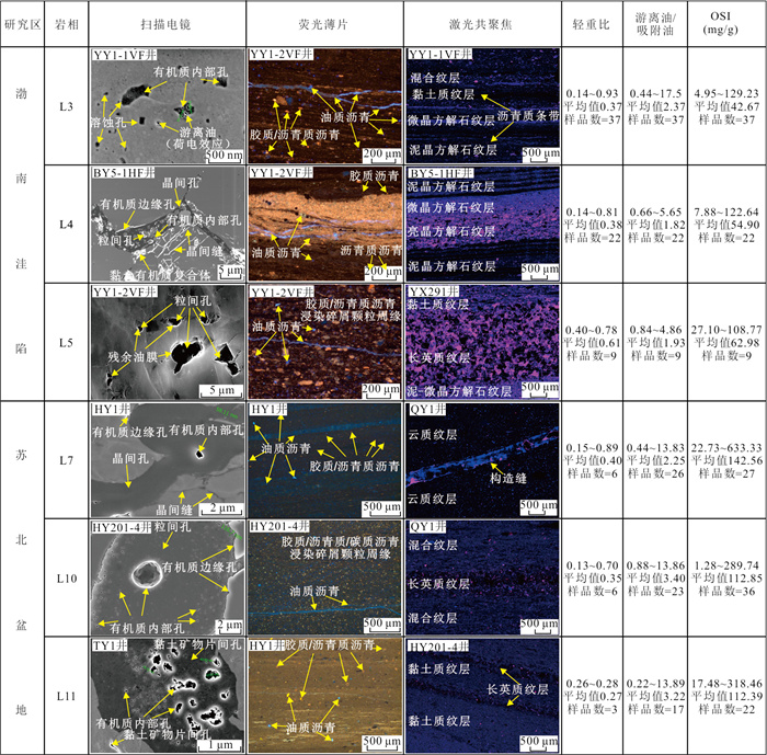
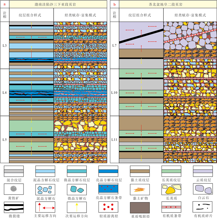
The Lower Es3 sub-member (Bonan subsag) and Fu2 member (Subei basin) represent typical mixed sedimentary shale reservoirs in eastern China. They share common characteristics such as multi-source hydrocarbon supply, source-reservoir coexistence, and micro-migration of hydrocarbons to dominant layers. However, they also exhibit significant differences in burial mode, thermal evolution degree, lithofacies development, and reservoir properties, which have restricted the in-depth study of shale oil enrichment patterns in continental mixed sedimentary shale reservoirs.This study selected the two sets of typical continental mixed shale reservoirs as research objects. Based on a systematic review of previous research methods and findings, a variety of experimental techniques were comprehensively employed to conduct comparative studies on reservoir differences and analyze enrichment mechanisms, thereby clarifying the shale oil enrichment patterns.The results show follows. ①Burial mode affects the basic reservoir characteristics by controlling mineral composition and sedimentary structure types. ②Vitrinite reflectance (Ro) not only determines oil-bearing property and occurrence characteristics, but also continuously modifies reservoir space types through thermal evolution. ③ Differences in reservoir space control the direction of hydrocarbon micro-migration, while the oil-bearing property and hydrocarbon proportion of surrounding laminae affect the initiation and intensity of micro-migration. Furthermore, the shale oil enrichment patterns of dominant lithofacies in the two study areas are revealed: the Lower Es3 sub-member (Bonan subsag) is dominated by "mud-generating and limestone-storing" and "mud-generating and sand-storing" modes, while Fu2 member (Subei basin) is characterized by "mud-generating and dolomite-storing" and "mud-generating and sand-storing" modes.Appropriate maturity, sufficient organic matter supply, high macropore proportion, and a well-developed pore-fracture system are the core controlling factors for shale oil enrichment. A hydrocarbon allocation effect exists within lamina assemblages that meet the above conditions-light free hydrocarbons can micro-migrate to adjacent laminae with enrichment potential and then migrate laterally into macropores for accumulation. The shale oil enrichment pattern constructed in this study provides a feasible framework for the analogy evaluation of mixed sedimentary shale reservoirs and deepens the understanding of the enrichment and high-yield mechanism of shale oil under source-reservoir coupling control.
The Lower Es3 sub-member (Bonan subsag) and Fu2 member (Subei basin) represent typical mixed sedimentary shale reservoirs in eastern China. They share common characteristics such as multi-source hydrocarbon supply, source-reservoir coexistence, and micro-migration of hydrocarbons to dominant layers. However, they also exhibit significant differences in burial mode, thermal evolution degree, lithofacies development, and reservoir properties, which have restricted the in-depth study of shale oil enrichment patterns in continental mixed sedimentary shale reservoirs.This study selected the two sets of typical continental mixed shale reservoirs as research objects. Based on a systematic review of previous research methods and findings, a variety of experimental techniques were comprehensively employed to conduct comparative studies on reservoir differences and analyze enrichment mechanisms, thereby clarifying the shale oil enrichment patterns.The results show follows. ①Burial mode affects the basic reservoir characteristics by controlling mineral composition and sedimentary structure types. ②Vitrinite reflectance (Ro) not only determines oil-bearing property and occurrence characteristics, but also continuously modifies reservoir space types through thermal evolution. ③ Differences in reservoir space control the direction of hydrocarbon micro-migration, while the oil-bearing property and hydrocarbon proportion of surrounding laminae affect the initiation and intensity of micro-migration. Furthermore, the shale oil enrichment patterns of dominant lithofacies in the two study areas are revealed: the Lower Es3 sub-member (Bonan subsag) is dominated by "mud-generating and limestone-storing" and "mud-generating and sand-storing" modes, while Fu2 member (Subei basin) is characterized by "mud-generating and dolomite-storing" and "mud-generating and sand-storing" modes.Appropriate maturity, sufficient organic matter supply, high macropore proportion, and a well-developed pore-fracture system are the core controlling factors for shale oil enrichment. A hydrocarbon allocation effect exists within lamina assemblages that meet the above conditions-light free hydrocarbons can micro-migrate to adjacent laminae with enrichment potential and then migrate laterally into macropores for accumulation. The shale oil enrichment pattern constructed in this study provides a feasible framework for the analogy evaluation of mixed sedimentary shale reservoirs and deepens the understanding of the enrichment and high-yield mechanism of shale oil under source-reservoir coupling control.
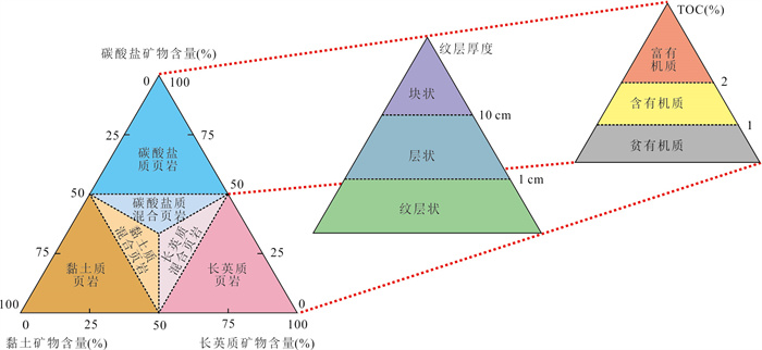
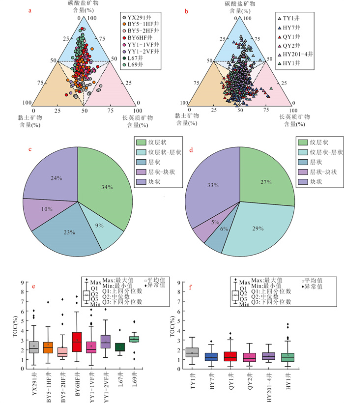
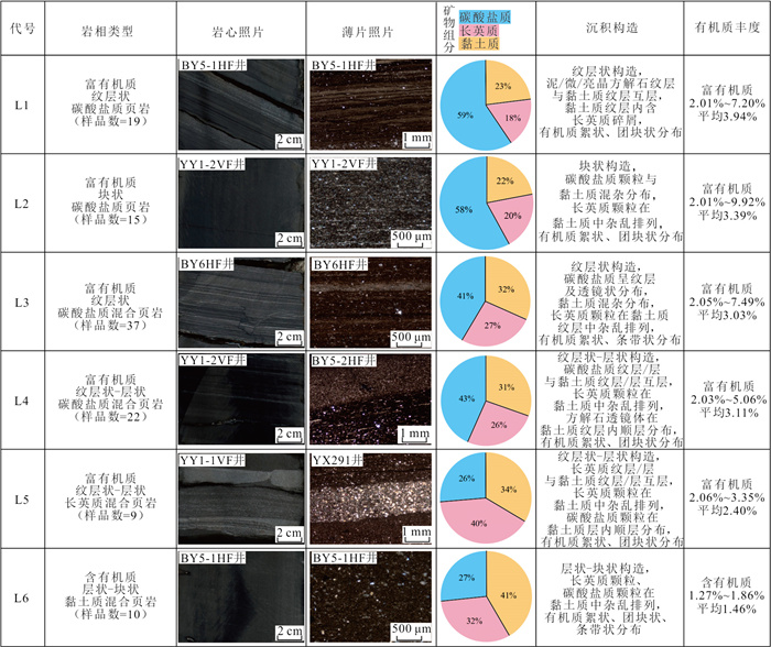
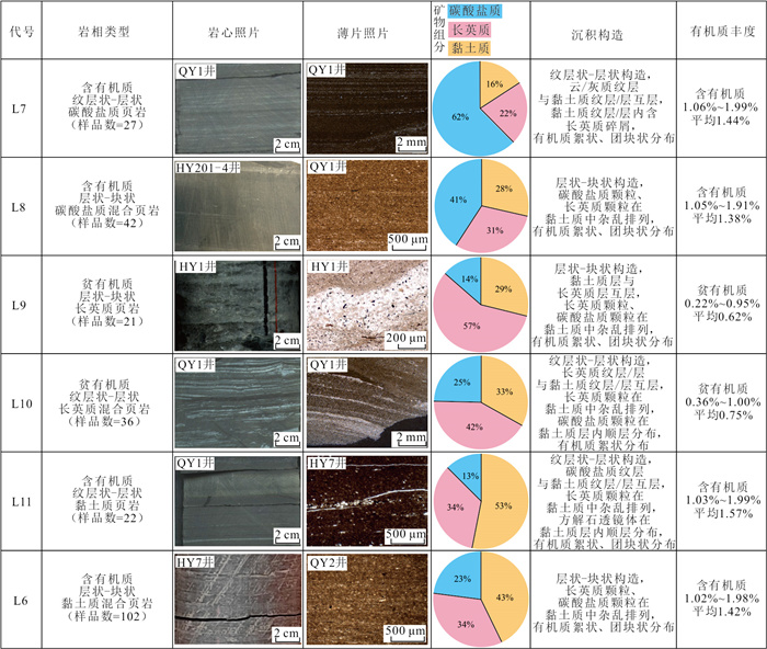
2026, 51(5): 1721-1735.
doi: 10.3799/dqkx.2026.011
Abstract:
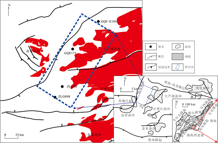
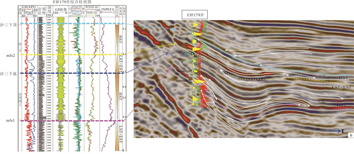
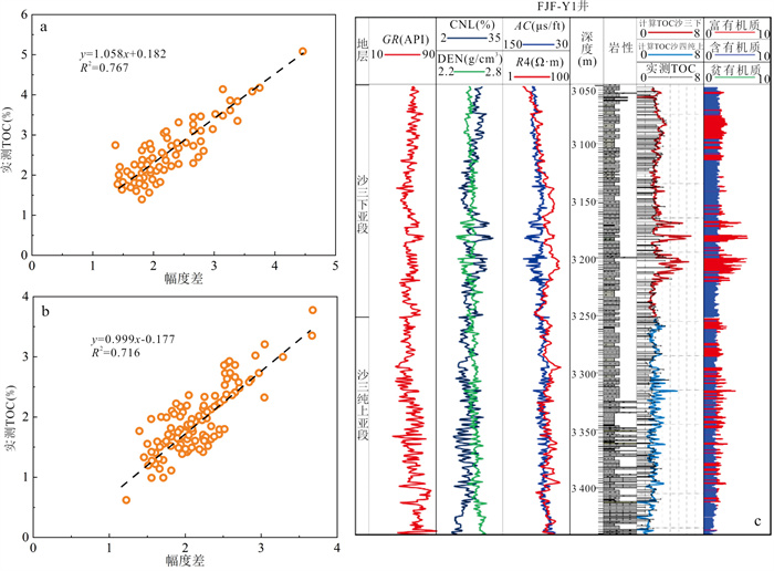
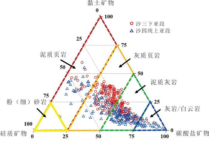
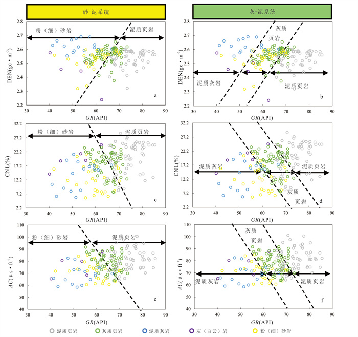
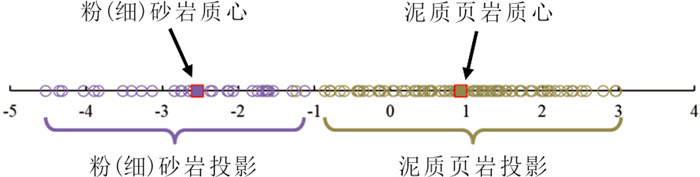
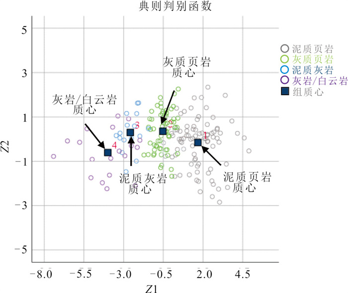
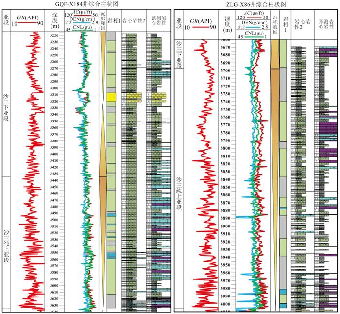
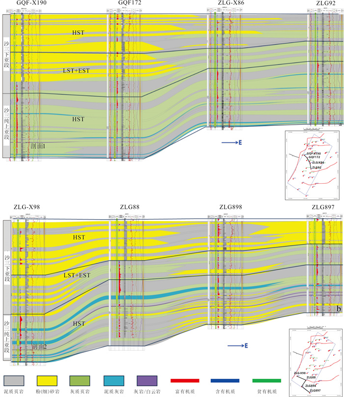
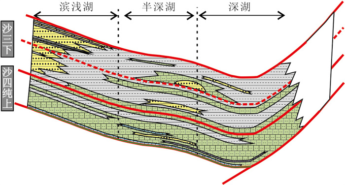
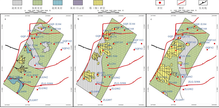
The lithological complexity and strong heterogeneity of the mixed siliciclastic and carbonate reservoirs result in difficulties in lithofacies identification and insufficient understanding of depositional patterns in the upper Shahejie 4 Member and lower Shahejie 3 Member in the western Daluhu oilfield, Bohai Bay basin. Integrating drilling, logging, and seismic data, Fisher discriminant analysis was applied for quantitative characterization of mixed siliciclastic and carbonate lithofacies from well logs, and the depositional evolution of mixed sediments was comprehensively revealed, on the basis of a chronostratigraphic framework. The results are as follows. (1) Based on Fisher discriminant analysis, quantitative lithology identification models for sand-mudstone and limestone-mudstone systems were established within subsequences using optimally selected natural gamma ray (GR), Sonic transit time (AC), density (DEN) and compensated neutron (CNL) logging curves, effectively addressing the problem of overlapping log responses between limestone and sandstone and significantly improving lithology identification accuracy. For the sand-mudstone system, the lithology identification accuracy in the validation set was 79.5%, with a siltstone prediction accuracy of 95%; for the limestone-mudstone system, the overall back-prediction accuracy reached 84.5%. (2) The highstand systems tract (HST) of the upper Shahejie 4 Member is dominated by shallow-lake to semi-deep-lake facies, consisting of interbedded calcareous shale and mudstone. Controlled by paleo-water depth and salinity, organic matter is enriched in the central-western and locally in the southeastern parts, with contents mainly between 0.8%-1.9%. The lowstand and lake-expansion systems tracts of the lower Shahejie 3 Member are dominated by semi-deep-lake facies, with organic matter enriched in the northern and southern areas and TOC content concentrated at 0.9%-2.3%. The HST of the lower Shahejie 3 Member developed a braided-river delta-semi-deep lake composite depositional system, with delta-front siltstone facies developed along the basin margins, resulting in poorer organic matter preservation, whereas the sag center was dominated by semi-deep lacustrine deposits, with organic-rich argillaceous shale being predominant. (3) Four types of vertical lithofacies association models were established: thick-bedded sandstone interbedded with thin mudstone, thick-bedded mudstone interbedded with thin sandstone, thick-bedded calcareous shale interbedded with thin mudstone, and thick-bedded mudstone interbedded with thin calcareous shale. In plan view, the mixed siliciclastic-carbonate depositional system is characterized by braided-river delta and nearshore subaqueous fan complexes along the western and southwestern steep margins. Slump-induced turbidite bodies developed in the slope zones and lake basin below the slope-break belts of the lowstand and highst and systems tracts. In the eastern and northeastern gentle-slope areas, calcareous-dominated sedimentary facies developed in semi-deep to deep lacustrine environments, while muddy shale and calcareous shale facies shifted toward the basin center. This study provides a quantitative theoretical basis for lacustrine mixed lithofacies prediction from well logs, offering guidance for organic-rich source rock and reservoir prediction, depositional pattern analysis, and oil and gas exploration.
The lithological complexity and strong heterogeneity of the mixed siliciclastic and carbonate reservoirs result in difficulties in lithofacies identification and insufficient understanding of depositional patterns in the upper Shahejie 4 Member and lower Shahejie 3 Member in the western Daluhu oilfield, Bohai Bay basin. Integrating drilling, logging, and seismic data, Fisher discriminant analysis was applied for quantitative characterization of mixed siliciclastic and carbonate lithofacies from well logs, and the depositional evolution of mixed sediments was comprehensively revealed, on the basis of a chronostratigraphic framework. The results are as follows. (1) Based on Fisher discriminant analysis, quantitative lithology identification models for sand-mudstone and limestone-mudstone systems were established within subsequences using optimally selected natural gamma ray (GR), Sonic transit time (AC), density (DEN) and compensated neutron (CNL) logging curves, effectively addressing the problem of overlapping log responses between limestone and sandstone and significantly improving lithology identification accuracy. For the sand-mudstone system, the lithology identification accuracy in the validation set was 79.5%, with a siltstone prediction accuracy of 95%; for the limestone-mudstone system, the overall back-prediction accuracy reached 84.5%. (2) The highstand systems tract (HST) of the upper Shahejie 4 Member is dominated by shallow-lake to semi-deep-lake facies, consisting of interbedded calcareous shale and mudstone. Controlled by paleo-water depth and salinity, organic matter is enriched in the central-western and locally in the southeastern parts, with contents mainly between 0.8%-1.9%. The lowstand and lake-expansion systems tracts of the lower Shahejie 3 Member are dominated by semi-deep-lake facies, with organic matter enriched in the northern and southern areas and TOC content concentrated at 0.9%-2.3%. The HST of the lower Shahejie 3 Member developed a braided-river delta-semi-deep lake composite depositional system, with delta-front siltstone facies developed along the basin margins, resulting in poorer organic matter preservation, whereas the sag center was dominated by semi-deep lacustrine deposits, with organic-rich argillaceous shale being predominant. (3) Four types of vertical lithofacies association models were established: thick-bedded sandstone interbedded with thin mudstone, thick-bedded mudstone interbedded with thin sandstone, thick-bedded calcareous shale interbedded with thin mudstone, and thick-bedded mudstone interbedded with thin calcareous shale. In plan view, the mixed siliciclastic-carbonate depositional system is characterized by braided-river delta and nearshore subaqueous fan complexes along the western and southwestern steep margins. Slump-induced turbidite bodies developed in the slope zones and lake basin below the slope-break belts of the lowstand and highst and systems tracts. In the eastern and northeastern gentle-slope areas, calcareous-dominated sedimentary facies developed in semi-deep to deep lacustrine environments, while muddy shale and calcareous shale facies shifted toward the basin center. This study provides a quantitative theoretical basis for lacustrine mixed lithofacies prediction from well logs, offering guidance for organic-rich source rock and reservoir prediction, depositional pattern analysis, and oil and gas exploration.
2026, 51(5): 1736-1748.
doi: 10.3799/dqkx.2026.129
Abstract:
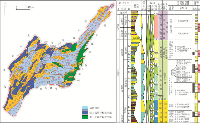
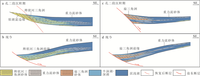
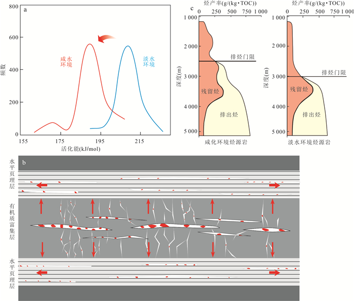
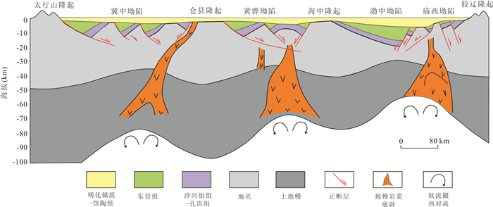
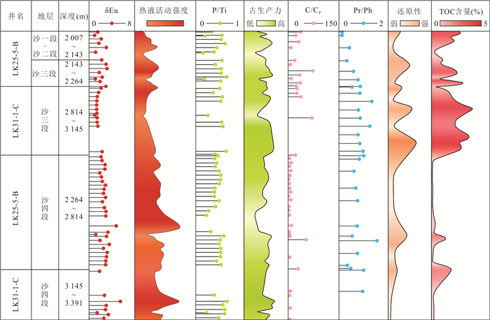
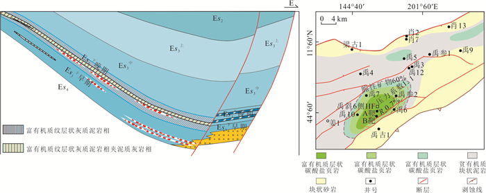
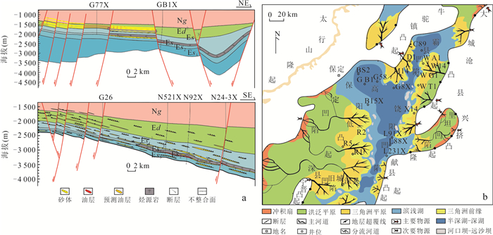
To further clarify the direction of oil and gas exploration in low exploration degree depression during the "15th Five-Year Plan" period, based on an analysis of the recent development and progress of oil and gas exploration in the Bohai Bay super basin, this study reveals new insights into the sources of oil and gas, systematically sorts out the applicability of these insights, conducts prioritization and selection research, and finally proposes exploration ideas for low exploration degree depression. The results reveal three new understandings about the sources of oil and gas in low exploration degree depression. First, there is an early hydrocarbon generation and multi-stage hydrocarbon generation mechanism in organic-rich algal source rocks of salinized lakes. Second, local thermal anomalies and hydrocarbon source rocks in salinized lakes reveal the potential for hydrocarbon generation in small and shallow sags. Third, the oil and gas originate from long-distance transport in adjacent major oil-rich sags. According to the current exploration progress, the theoretical and technological achievements in low exploration degree depression will boost the increase in reserves and production of oil and gas in the Bohai Bay basin, which has important theoretical and practical significance for ensuring energy supply in the eastern region and driving regional socio-economic development.
To further clarify the direction of oil and gas exploration in low exploration degree depression during the "15th Five-Year Plan" period, based on an analysis of the recent development and progress of oil and gas exploration in the Bohai Bay super basin, this study reveals new insights into the sources of oil and gas, systematically sorts out the applicability of these insights, conducts prioritization and selection research, and finally proposes exploration ideas for low exploration degree depression. The results reveal three new understandings about the sources of oil and gas in low exploration degree depression. First, there is an early hydrocarbon generation and multi-stage hydrocarbon generation mechanism in organic-rich algal source rocks of salinized lakes. Second, local thermal anomalies and hydrocarbon source rocks in salinized lakes reveal the potential for hydrocarbon generation in small and shallow sags. Third, the oil and gas originate from long-distance transport in adjacent major oil-rich sags. According to the current exploration progress, the theoretical and technological achievements in low exploration degree depression will boost the increase in reserves and production of oil and gas in the Bohai Bay basin, which has important theoretical and practical significance for ensuring energy supply in the eastern region and driving regional socio-economic development.
2026, 51(5): 1749-1767.
doi: 10.3799/dqkx.2026.135
Abstract:
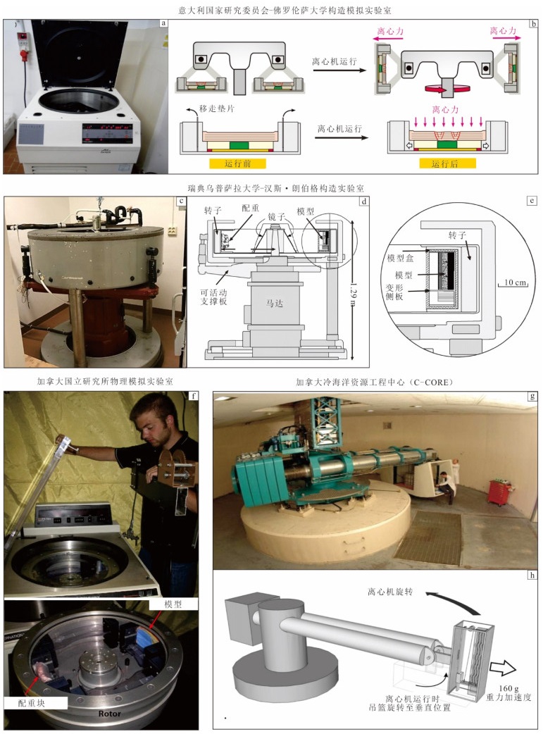
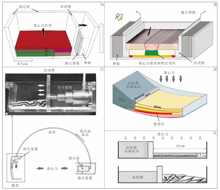
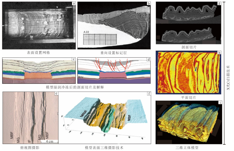
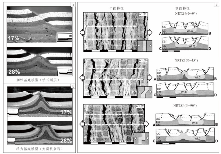
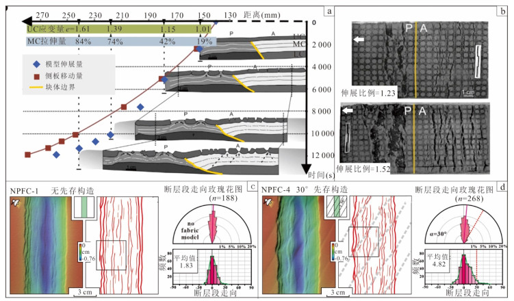
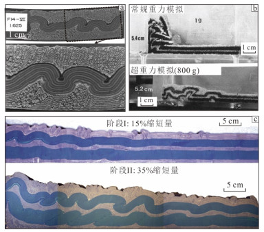
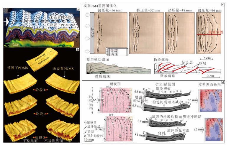
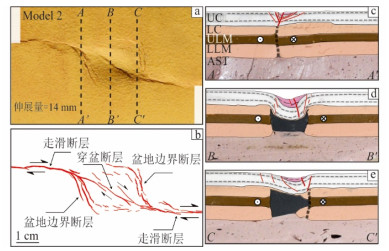
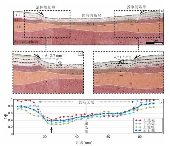
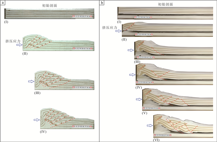
Centrifuge analogue modelling is an effective method to reproduce the tectonic deformation process of the crust-lithosphere scale with a multi-layer rheological structure. Due to its important role in investigating deep rheological architectures and their influence on brittle deformation in the upper crust, it has been widely applied to studies of diapirism, fold-and-thrust belts, continental extension, magma-rift interactions, and strike-slip pull-apart basins. In this study, the development history of centrifuge analogue tectonic modeling is summarized, and the modelling principles, apparatus, materials, and recent advances in monitoring and analysis techniques are discussed in detail. Differences between centrifuge and normal gravity analogue modeling experiments are systematically compared. Representative applications of centrifuge analogue modeling under different tectonic settings are analyzed, including extensional, compressional, strike-slip, and salt/magmatic tectonic regimes. Finally, it presents the application prospects of centrifuge analogue modelling in hydrocarbon exploration and deep-earth system research and discuss the future development direction of this technology.
Centrifuge analogue modelling is an effective method to reproduce the tectonic deformation process of the crust-lithosphere scale with a multi-layer rheological structure. Due to its important role in investigating deep rheological architectures and their influence on brittle deformation in the upper crust, it has been widely applied to studies of diapirism, fold-and-thrust belts, continental extension, magma-rift interactions, and strike-slip pull-apart basins. In this study, the development history of centrifuge analogue tectonic modeling is summarized, and the modelling principles, apparatus, materials, and recent advances in monitoring and analysis techniques are discussed in detail. Differences between centrifuge and normal gravity analogue modeling experiments are systematically compared. Representative applications of centrifuge analogue modeling under different tectonic settings are analyzed, including extensional, compressional, strike-slip, and salt/magmatic tectonic regimes. Finally, it presents the application prospects of centrifuge analogue modelling in hydrocarbon exploration and deep-earth system research and discuss the future development direction of this technology.
2026, 51(5): 1768-1786.
doi: 10.3799/dqkx.2026.165
Abstract:
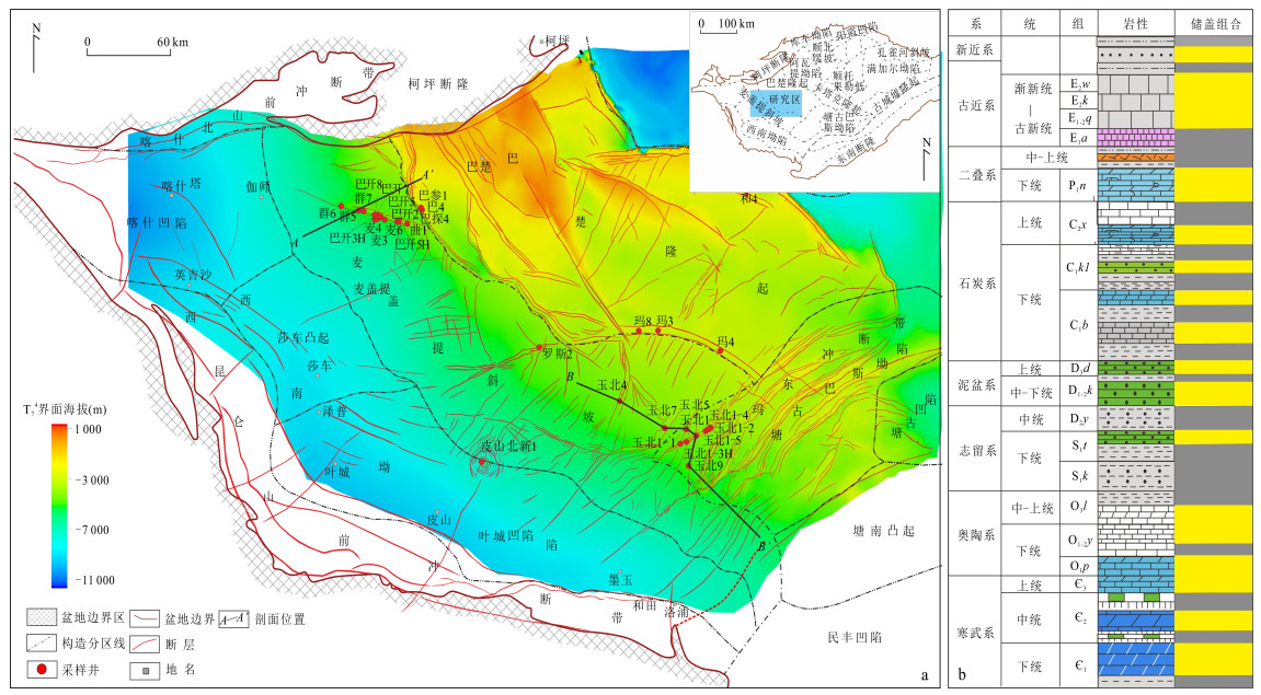
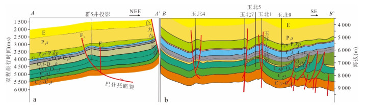
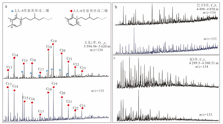
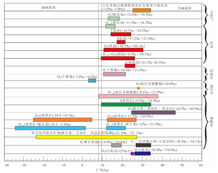
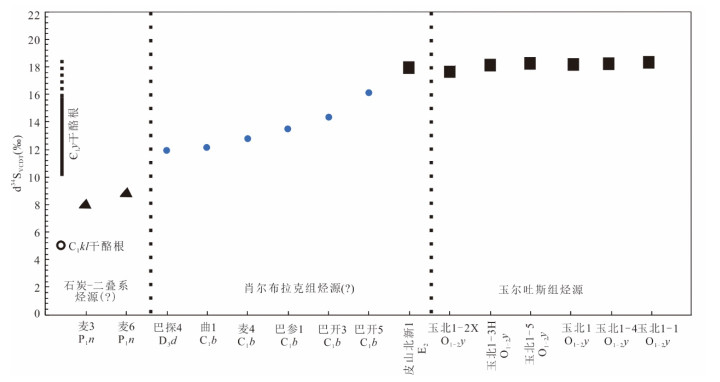
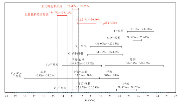
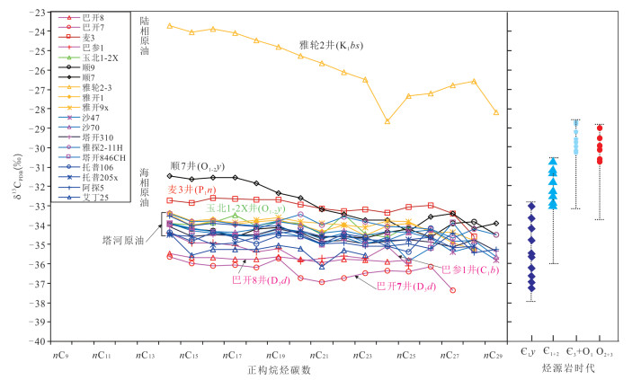
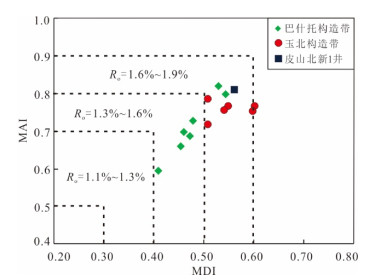
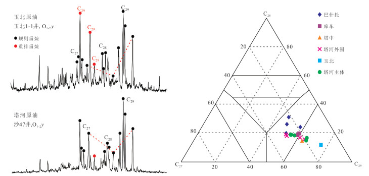
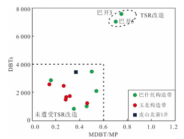
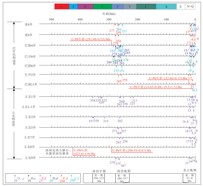
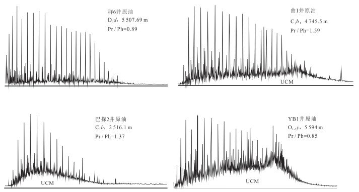
Since 1952, more than 70 years of the petroleum exploration in the southwest depression of Tarim basin have witnessed the discovery of.several petroleum fields including Bashentuo and Yubei etc., but there is a huge gap for petroleum exploration in comparison with Tabei depression. The key factor is the long-standing argument of uncertain hydrocarbon sources constraining the deployment in this area. In this research, 34 crude oil samples in Tarim basin have been collected to analyze their aryl isoprenoids, sulfur isotopic ratio and composite specific carbon isotopic ratio, which has been utilized for oil correlation and difference comparison of oil properties between Bashentuo and Yubei structures by cooperating stable carbon isotopic ratios of kerogens and bulk oils and hydrocarbon charging process. Several significant results have been obtained as follows. (1) The hydrocarbon in Yubei structure mainly comes from the Lower Cambrian Yuertusi Formation (∈1y) source rock, and from Xiaoerbulake Formation (∈1x) source rock locally. The hydrocarbon in Bashentuo structure possibly mainly comes from the Lower Cambrian Xiaoerbulake Formation (∈1x) source rock, and from the Carboniferous and Permian source rocks locally. (2) Three hydrocarbon charging events occurred in Yubei structure during the middle Hycynian, the late Hycynian and Himalayan, respectively, and the first and second events consist of the main charging hydrocarbons which underwent quite strong biodegradation; only two charging events took place in Bashentuo structure during the late Hycynian and the Himalayan, respectively, and the second event is composed of the main charging hydrocarbon, and the first charging oil underwent weak biodegradation locally. (3) The reasons of light oil and condensate accumulated in Bashentuo structure and medium quality oil accumulated in Yubei structure are due to the differences of sources, charging events and degrees of biodegradation during the late Hycynian. Therefore, the key for the future exploration is to reinforce the geochemical study of source rocks of Xiaoerbulake Formation and the Carboniferous and Permian in the southwest Tarim basin.
Since 1952, more than 70 years of the petroleum exploration in the southwest depression of Tarim basin have witnessed the discovery of.several petroleum fields including Bashentuo and Yubei etc., but there is a huge gap for petroleum exploration in comparison with Tabei depression. The key factor is the long-standing argument of uncertain hydrocarbon sources constraining the deployment in this area. In this research, 34 crude oil samples in Tarim basin have been collected to analyze their aryl isoprenoids, sulfur isotopic ratio and composite specific carbon isotopic ratio, which has been utilized for oil correlation and difference comparison of oil properties between Bashentuo and Yubei structures by cooperating stable carbon isotopic ratios of kerogens and bulk oils and hydrocarbon charging process. Several significant results have been obtained as follows. (1) The hydrocarbon in Yubei structure mainly comes from the Lower Cambrian Yuertusi Formation (∈1y) source rock, and from Xiaoerbulake Formation (∈1x) source rock locally. The hydrocarbon in Bashentuo structure possibly mainly comes from the Lower Cambrian Xiaoerbulake Formation (∈1x) source rock, and from the Carboniferous and Permian source rocks locally. (2) Three hydrocarbon charging events occurred in Yubei structure during the middle Hycynian, the late Hycynian and Himalayan, respectively, and the first and second events consist of the main charging hydrocarbons which underwent quite strong biodegradation; only two charging events took place in Bashentuo structure during the late Hycynian and the Himalayan, respectively, and the second event is composed of the main charging hydrocarbon, and the first charging oil underwent weak biodegradation locally. (3) The reasons of light oil and condensate accumulated in Bashentuo structure and medium quality oil accumulated in Yubei structure are due to the differences of sources, charging events and degrees of biodegradation during the late Hycynian. Therefore, the key for the future exploration is to reinforce the geochemical study of source rocks of Xiaoerbulake Formation and the Carboniferous and Permian in the southwest Tarim basin.
2026, 51(5): 1787-1802.
doi: 10.3799/dqkx.2026.143
Abstract:
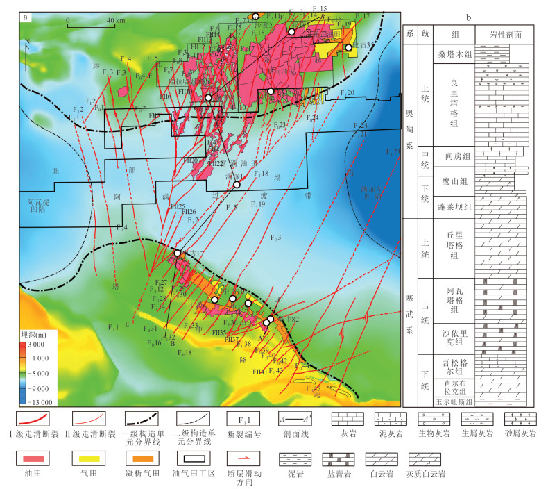
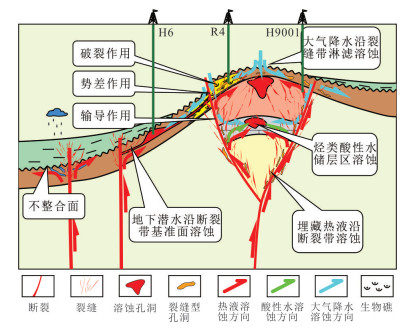
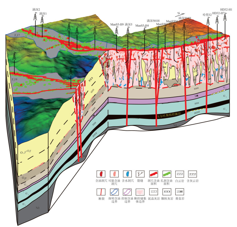
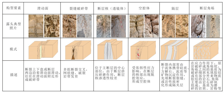
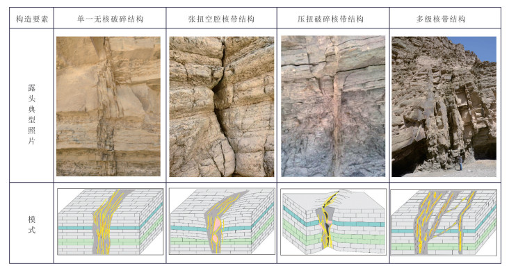
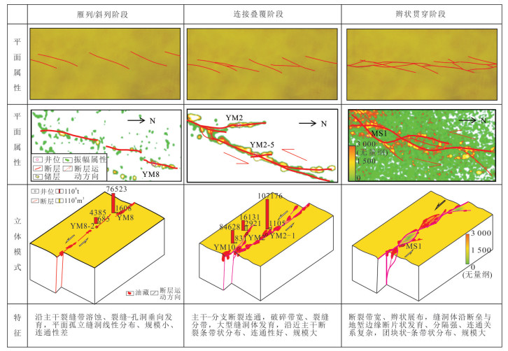
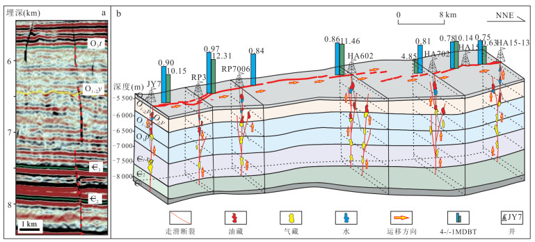
Aiming at the exploration challenges of ultra-deep carbonate reservoirs in the platform area of the Tarim Basin, in this paper it systematically summarizes theoretical advances in strike-slip fault-controlling reservoir formation and hydrocarbon accumulation. It establishes a "facies-fault-dissolution" ternary composite reservoir-control mechanism, revealing that low-order faults dominate high-quality reservoir development by constructing high-density fracture networks through a "weak activity-strong modification" process. Furthermore, it constructs a "source-fault-reservoir-seal" quaternary coupled accumulation model, elucidating how the spatiotemporal coupling of multi-phase fault activities with hydrocarbon charging, along with segmented sealing properties, governs the enrichment patterns characterized by "fault-block control, one block per pool, and small pools forming giant fields." The paper highlights current challenges in quantitative evaluation of fault sealing, delineation of deep fluid activity timelines, high-precision 3D modeling, and AI-based intelligent identification. Future research should focus on the multi-scale synergistic evolution of faults, fluids, and karst systems, deepening the understanding of intrinsic relationships among key factors to support precise prediction and efficient exploration of ultra-deep oil and gas resources.
Aiming at the exploration challenges of ultra-deep carbonate reservoirs in the platform area of the Tarim Basin, in this paper it systematically summarizes theoretical advances in strike-slip fault-controlling reservoir formation and hydrocarbon accumulation. It establishes a "facies-fault-dissolution" ternary composite reservoir-control mechanism, revealing that low-order faults dominate high-quality reservoir development by constructing high-density fracture networks through a "weak activity-strong modification" process. Furthermore, it constructs a "source-fault-reservoir-seal" quaternary coupled accumulation model, elucidating how the spatiotemporal coupling of multi-phase fault activities with hydrocarbon charging, along with segmented sealing properties, governs the enrichment patterns characterized by "fault-block control, one block per pool, and small pools forming giant fields." The paper highlights current challenges in quantitative evaluation of fault sealing, delineation of deep fluid activity timelines, high-precision 3D modeling, and AI-based intelligent identification. Future research should focus on the multi-scale synergistic evolution of faults, fluids, and karst systems, deepening the understanding of intrinsic relationships among key factors to support precise prediction and efficient exploration of ultra-deep oil and gas resources.
2026, 51(5): 1803-1818.
doi: 10.3799/dqkx.2026.133
Abstract:
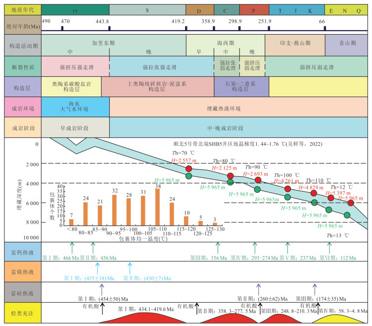
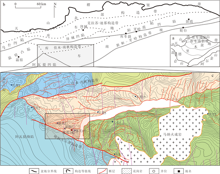
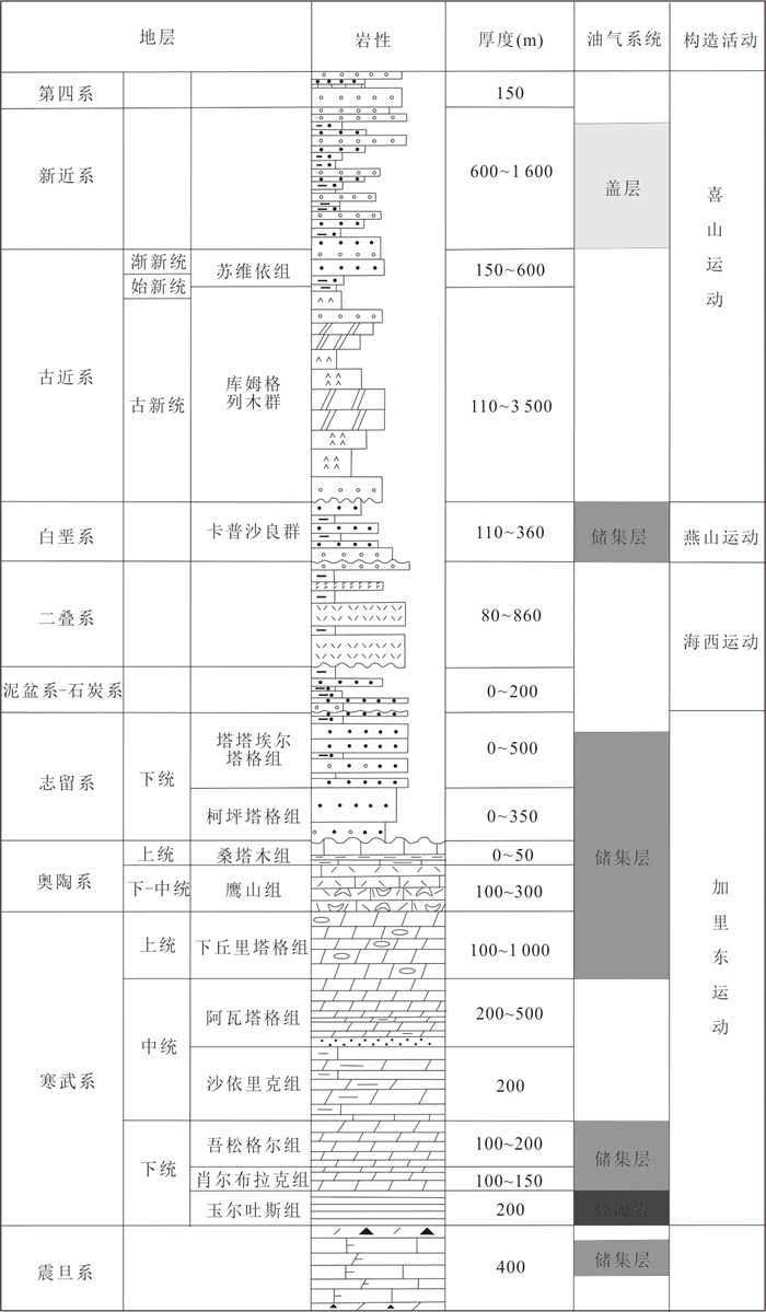
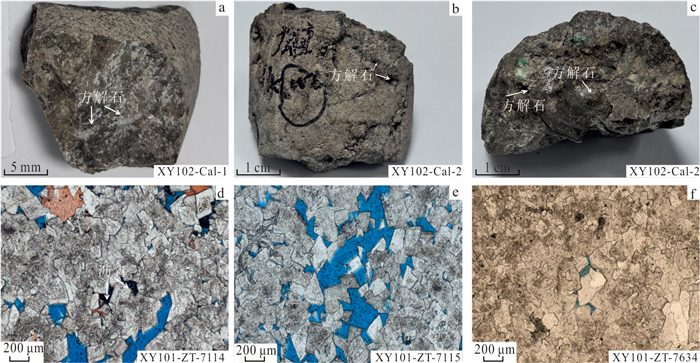
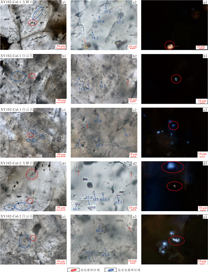
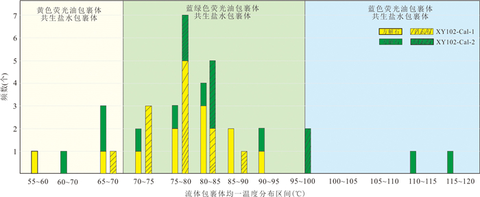
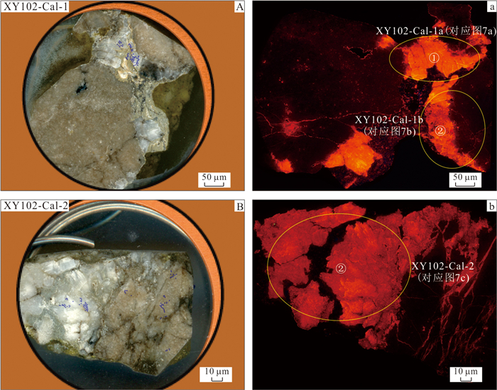
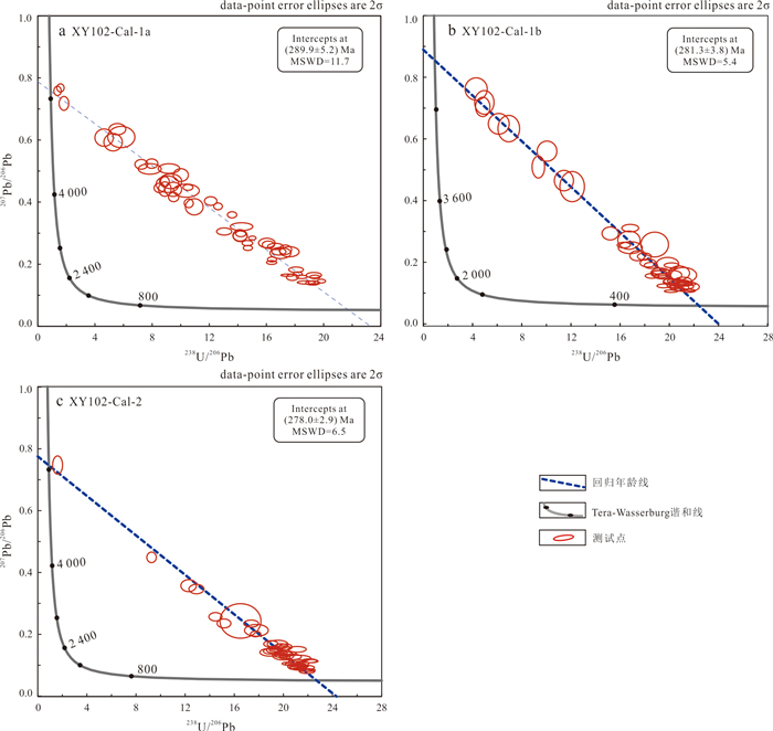
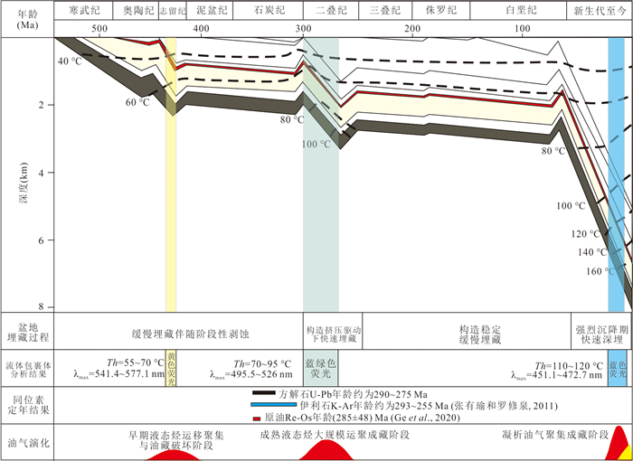
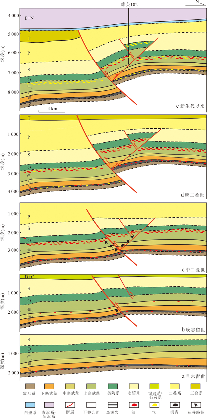
Accurately obtaining the key timings of hydrocarbon evolution in reservoirs is crucial for understanding the hydrocarbon accumulation process and improving the success rate of deep and ultra-deep hydrocarbon exploration. In recent years, with the improved precision of isotope analysis, radioactive isotope analysis of minerals related to hydrocarbon has become an effective approach to determine the key timings of hydrocarbon accumulation. Taking the Cambrian ultra-deep oil reservoir in the Xiongying area on the southern slope of the Kuqa depression, Tarim basin as the research object, this study focuses on calcite fluid inclusions in reservoirs and in-situ laser U-Pb isotope dating, to jointly constrain the evolution process of the oil reservoir and establish hydrocarbon accumulation model, on the basis of tectonic evolution and the basin burial history. The analysis of reservoir fluid inclusions shows three types of fluorescent oil inclusions and the results of three phases of different homogenization temperatures of associated aqueous inclusions, which jointly indicate that the Xiongying area has experienced three phases of hydrocarbon migration and accumulation since the Paleozoic, i.e., the end of the Silurian, the Permian, and since the Miocene. Moreover, the U-Pb dating results of reservoir calcite ((278.0±2.9)-(289.9±5.2) Ma) are highly consistent with the authigenic illite K-Ar ages (293-255 Ma) of reservoirs and the crude oil Re-Os ages (about 285 Ma), indicating that the Late Hercynian tectonic movement period (Permian) played an important role in the oil reservoir accumulation process.This study further confirms the feasibility of in-situ laser U-Pb isotope dating of reservoir calcite in accurately constraining the timing of hydrocarbon accumulation. The combined application of hydrocarbon accumulation geochronology and traditional hydrocarbon accumulation processes can help deeply understand the hydrocarbon evolution process of deep and ultra-deep multi-cyclic superimposed basins, and provide support for the exploration of deep and ultra-deep hydrocarbons including those in the Tarim basin.
Accurately obtaining the key timings of hydrocarbon evolution in reservoirs is crucial for understanding the hydrocarbon accumulation process and improving the success rate of deep and ultra-deep hydrocarbon exploration. In recent years, with the improved precision of isotope analysis, radioactive isotope analysis of minerals related to hydrocarbon has become an effective approach to determine the key timings of hydrocarbon accumulation. Taking the Cambrian ultra-deep oil reservoir in the Xiongying area on the southern slope of the Kuqa depression, Tarim basin as the research object, this study focuses on calcite fluid inclusions in reservoirs and in-situ laser U-Pb isotope dating, to jointly constrain the evolution process of the oil reservoir and establish hydrocarbon accumulation model, on the basis of tectonic evolution and the basin burial history. The analysis of reservoir fluid inclusions shows three types of fluorescent oil inclusions and the results of three phases of different homogenization temperatures of associated aqueous inclusions, which jointly indicate that the Xiongying area has experienced three phases of hydrocarbon migration and accumulation since the Paleozoic, i.e., the end of the Silurian, the Permian, and since the Miocene. Moreover, the U-Pb dating results of reservoir calcite ((278.0±2.9)-(289.9±5.2) Ma) are highly consistent with the authigenic illite K-Ar ages (293-255 Ma) of reservoirs and the crude oil Re-Os ages (about 285 Ma), indicating that the Late Hercynian tectonic movement period (Permian) played an important role in the oil reservoir accumulation process.This study further confirms the feasibility of in-situ laser U-Pb isotope dating of reservoir calcite in accurately constraining the timing of hydrocarbon accumulation. The combined application of hydrocarbon accumulation geochronology and traditional hydrocarbon accumulation processes can help deeply understand the hydrocarbon evolution process of deep and ultra-deep multi-cyclic superimposed basins, and provide support for the exploration of deep and ultra-deep hydrocarbons including those in the Tarim basin.
2026, 51(5): 1819-1830.
doi: 10.3799/dqkx.2026.072
Abstract:
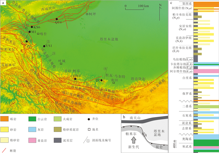
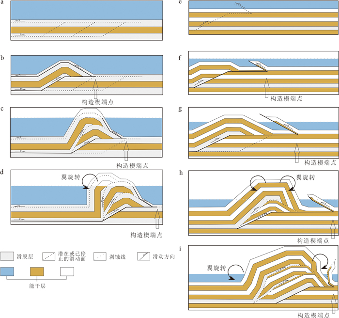
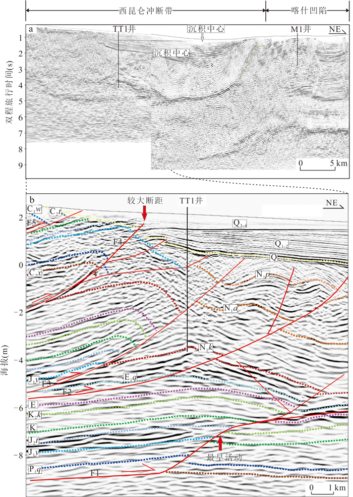
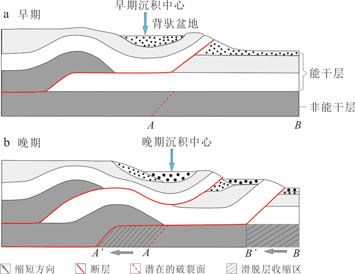
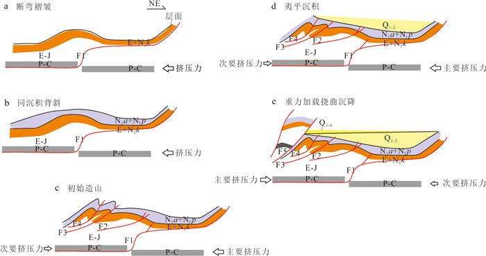
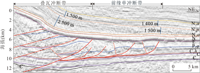
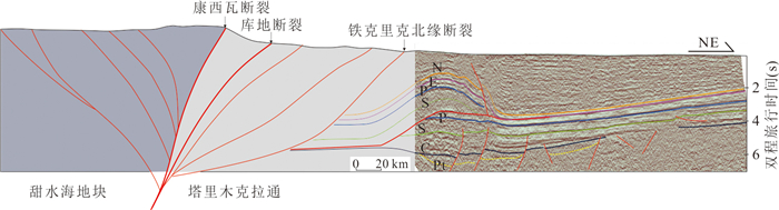
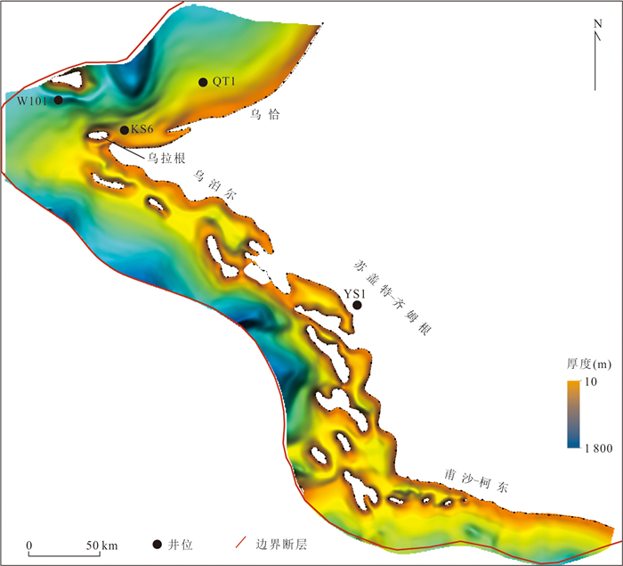
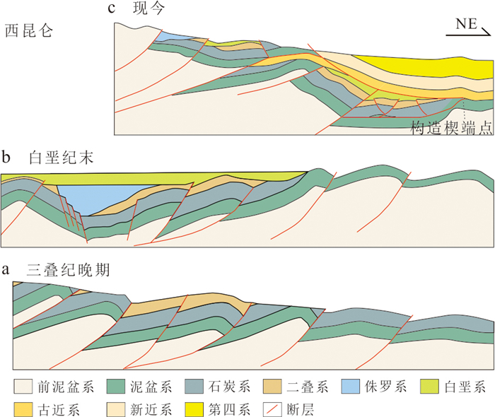
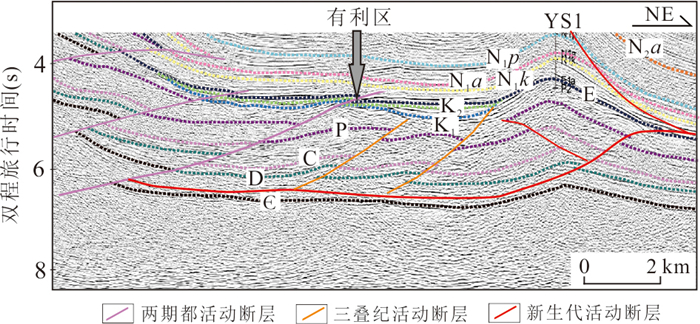
This study systematically analyzes the control of detachment layer distribution on structural style differences and trap-hydrocarbon generation coupling relationships in the frontal tectonic triangle zone of the Western Kunlun Mountains, based on seismic and drilling data. It is found that the evolution of the piggyback basin in the Upal section of the West Kunlun Mountains began with fault-bend folding controlled by Carboniferous-Permian and Paleogene detachment layers. Subsequently, the thrust in the fold core experienced intense uplift, ultimately leading to flexural subsidence due to rock gravity loading, completing a three-stage evolution process. The Sugaite-Qimugen-Kedong section, influenced by multiple detachment layers in the middle crust, Cambrian, and Carboniferous-Permian systems, develops imbricate thrust belts and frontal single-thrust zone. The former is dominated by Neogene-formed unsaturated hydrocarbon reservoirs, while the latter inherits Triassic structures with well-preserved traps, becoming a favorable area for Cretaceous hydrocarbon accumulation. At the endpoints of the tectonic wedge, intense erosion of source rocks generally results in a lack of effective hydrocarbon charging. The Duwa-Wujiate section only develops a Cambrian detachment surface, indicated by large-scale fault-bend folding and a lack Carboniferous-Permian source rocks. This study clarifies the critical role of detachment layers in controlling structural evolution and hydrocarbon distribution.
This study systematically analyzes the control of detachment layer distribution on structural style differences and trap-hydrocarbon generation coupling relationships in the frontal tectonic triangle zone of the Western Kunlun Mountains, based on seismic and drilling data. It is found that the evolution of the piggyback basin in the Upal section of the West Kunlun Mountains began with fault-bend folding controlled by Carboniferous-Permian and Paleogene detachment layers. Subsequently, the thrust in the fold core experienced intense uplift, ultimately leading to flexural subsidence due to rock gravity loading, completing a three-stage evolution process. The Sugaite-Qimugen-Kedong section, influenced by multiple detachment layers in the middle crust, Cambrian, and Carboniferous-Permian systems, develops imbricate thrust belts and frontal single-thrust zone. The former is dominated by Neogene-formed unsaturated hydrocarbon reservoirs, while the latter inherits Triassic structures with well-preserved traps, becoming a favorable area for Cretaceous hydrocarbon accumulation. At the endpoints of the tectonic wedge, intense erosion of source rocks generally results in a lack of effective hydrocarbon charging. The Duwa-Wujiate section only develops a Cambrian detachment surface, indicated by large-scale fault-bend folding and a lack Carboniferous-Permian source rocks. This study clarifies the critical role of detachment layers in controlling structural evolution and hydrocarbon distribution.
2026, 51(5): 1831-1848.
doi: 10.3799/dqkx.2026.016
Abstract:
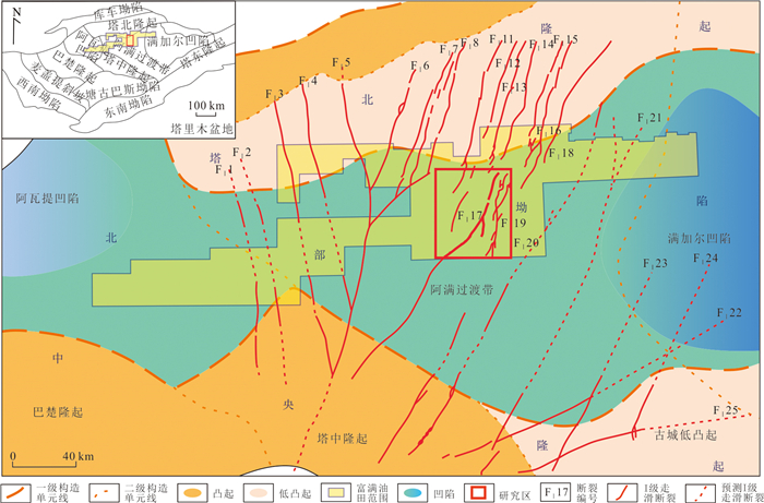
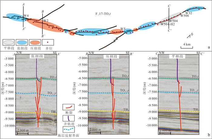
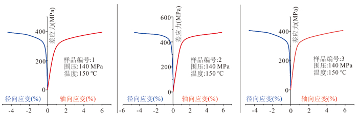
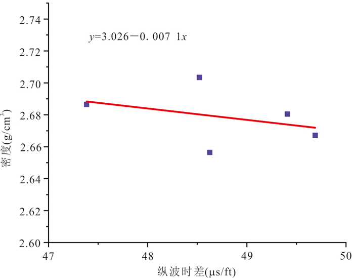
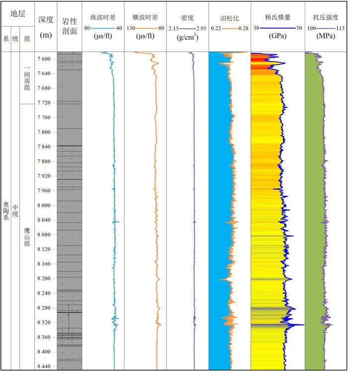
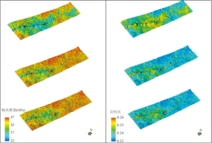
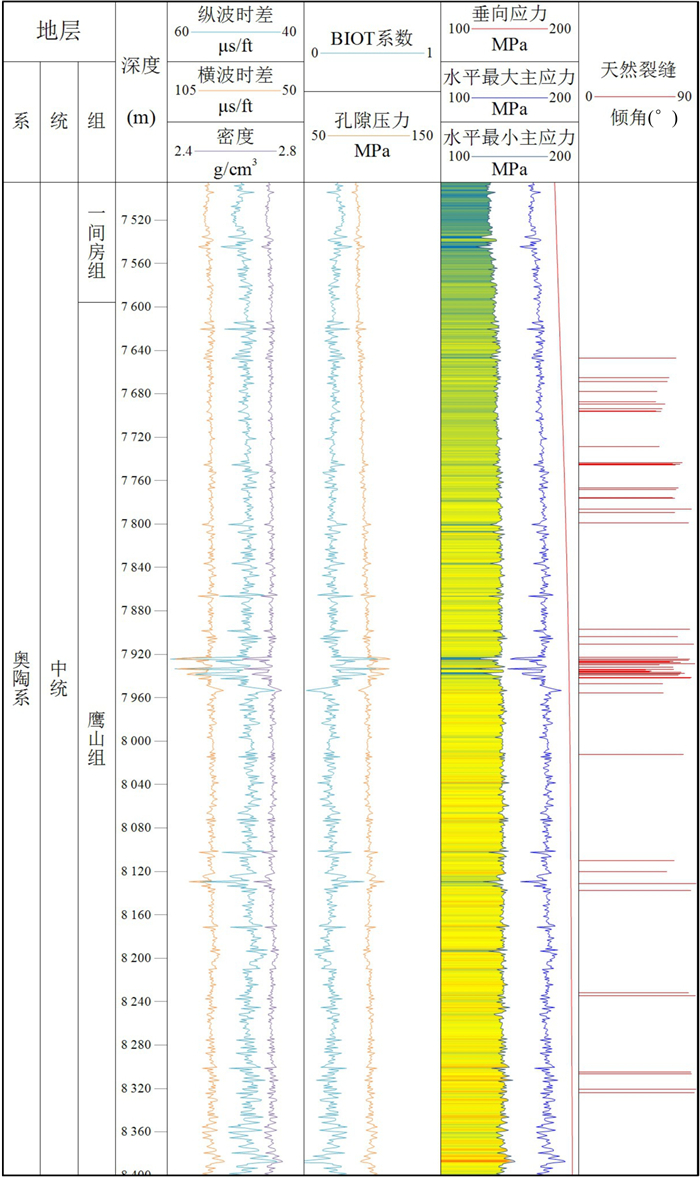
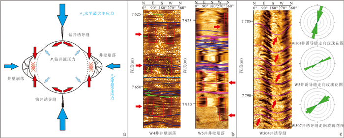
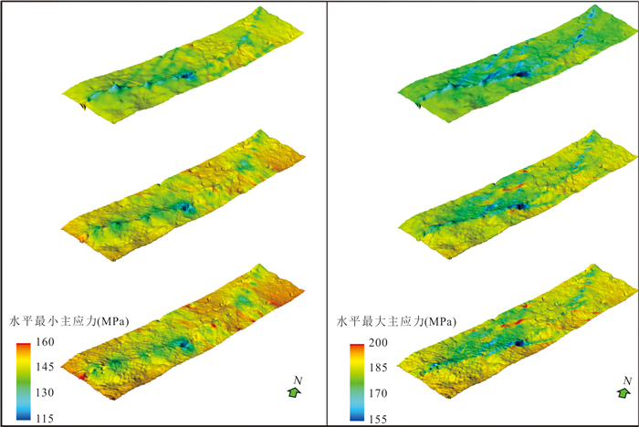
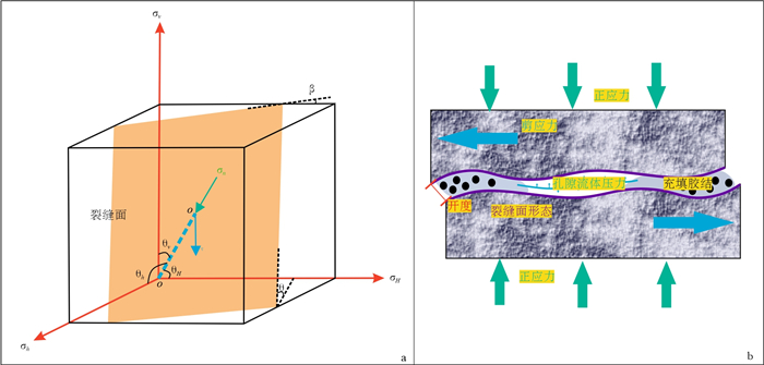
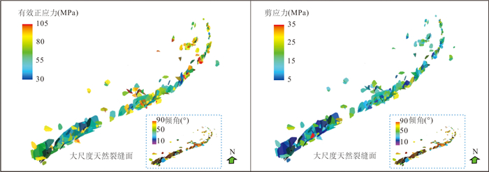
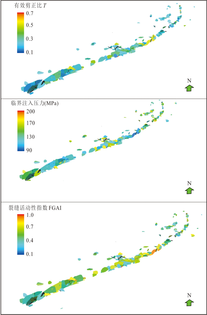
Geomechanical research in the ultra-deep carbonate rock domain of the Tarim basin has achieved a series of results, offering effective support to the exploration, development, and engineering practices of ultra-deep oil and gas resources. To facilitate further exploitation of the fracture-fragmented reservoir in the FⅠ17 fault zone of the Fuman oilfield, in this paper it integrates rock mechanics tests, single-well in-situ stress interpretation, and three-dimensional in-situ stress field simulations to clarify the geomechanical characteristics of the fault-controlled reservoirs in the FⅠ17 fault zone, on the basis of which the geomechanical responses of natural fractures associated with the FⅠ17 fault zone are analyzed. It is found that : ① The reservoir's Young's modulus ranges from 32-47 GPa, and Poisson's ratio ranges from 0.23-0.26. Elastic parameters exhibit vertical heterogeneity and planar differences between faults and surrounding rocks. Near fault development areas, a decrease in Young's modulus (approximately 20%) and an increase in Poisson's ratio (approximately 10%) are observed. ② The current minimum horizontal principal stress of the reservoir ranges from 110-170 MPa, and the maximum horizontal principal stress ranges from 145-205 MPa. The orientation of the maximum horizontal principal stress intersects the fault strike at a small angle, with significant stress drops (exceeding 15% locally) observed in the fault zone compared to the surrounding rocks. ③ The effective normal stress on large-scale natural fracture surfaces ranges from 30-105 MPa, and shear stress ranges from 5-35 MPa, influenced by in-situ stress, fracture orientation, and formation pore pressure. ④ Through stress calculations, the ratio of shear stress to effective normal stress of natural fractures primarily ranges from 0.1-0.55, the critical injection pressure ranges from 92-204 MPa, and the fracture geomechanical activity index (FGAI) ranges from 0.2-0.8, with an average of 0.48. High-angle fractures exhibit higher activity and are activated first after fluid injection. ⑤ When the formation pressure reaches the fracture closure pressure, the fractures will alter the connectivity state between fracture-cavity reservoir bodies. To avoid stress sensitivity damage after fracture closure, cyclic injection and production can be implemented.
Geomechanical research in the ultra-deep carbonate rock domain of the Tarim basin has achieved a series of results, offering effective support to the exploration, development, and engineering practices of ultra-deep oil and gas resources. To facilitate further exploitation of the fracture-fragmented reservoir in the FⅠ17 fault zone of the Fuman oilfield, in this paper it integrates rock mechanics tests, single-well in-situ stress interpretation, and three-dimensional in-situ stress field simulations to clarify the geomechanical characteristics of the fault-controlled reservoirs in the FⅠ17 fault zone, on the basis of which the geomechanical responses of natural fractures associated with the FⅠ17 fault zone are analyzed. It is found that : ① The reservoir's Young's modulus ranges from 32-47 GPa, and Poisson's ratio ranges from 0.23-0.26. Elastic parameters exhibit vertical heterogeneity and planar differences between faults and surrounding rocks. Near fault development areas, a decrease in Young's modulus (approximately 20%) and an increase in Poisson's ratio (approximately 10%) are observed. ② The current minimum horizontal principal stress of the reservoir ranges from 110-170 MPa, and the maximum horizontal principal stress ranges from 145-205 MPa. The orientation of the maximum horizontal principal stress intersects the fault strike at a small angle, with significant stress drops (exceeding 15% locally) observed in the fault zone compared to the surrounding rocks. ③ The effective normal stress on large-scale natural fracture surfaces ranges from 30-105 MPa, and shear stress ranges from 5-35 MPa, influenced by in-situ stress, fracture orientation, and formation pore pressure. ④ Through stress calculations, the ratio of shear stress to effective normal stress of natural fractures primarily ranges from 0.1-0.55, the critical injection pressure ranges from 92-204 MPa, and the fracture geomechanical activity index (FGAI) ranges from 0.2-0.8, with an average of 0.48. High-angle fractures exhibit higher activity and are activated first after fluid injection. ⑤ When the formation pressure reaches the fracture closure pressure, the fractures will alter the connectivity state between fracture-cavity reservoir bodies. To avoid stress sensitivity damage after fracture closure, cyclic injection and production can be implemented.
2026, 51(5): 1849-1860.
doi: 10.3799/dqkx.2026.090
Abstract:
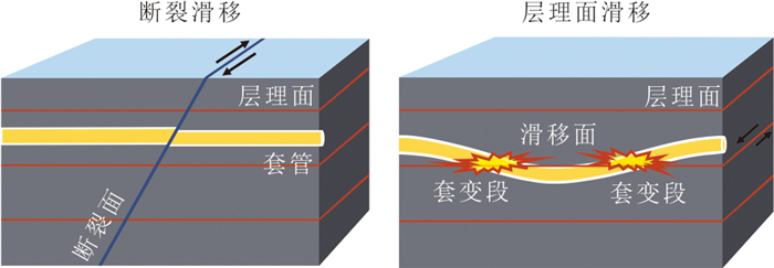
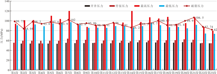
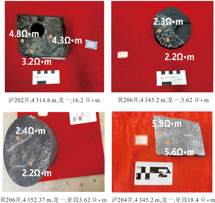
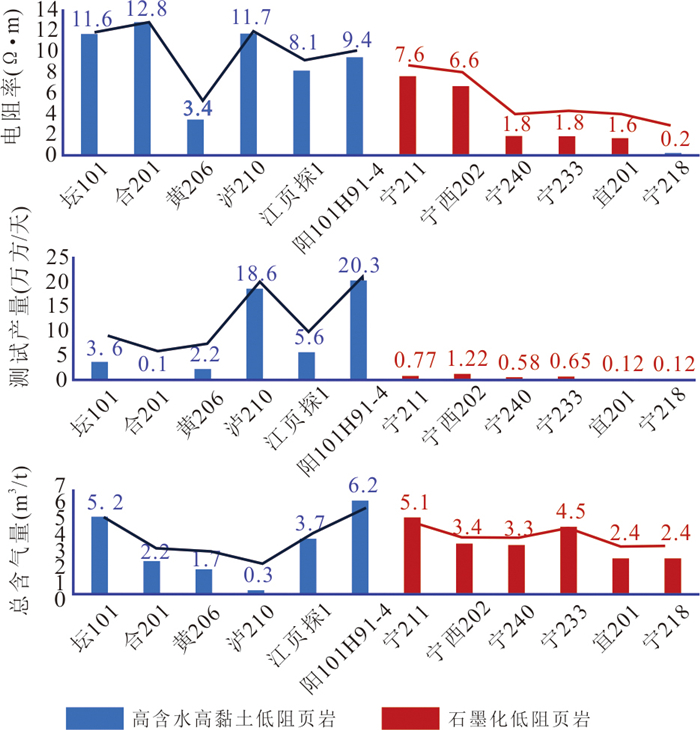
To address the frequent engineering problems and lower-than-expected construction and production in the development of deep shale gas in the Longmaxi Formation of South Sichuan, this study explores technical countermeasures for deep shale gas sweet spot evaluation through analysis of geological characteristics, sorting out development challenges and discussing their genesis.Results show that deep shale gas reservoirs (buried depth>3 500 m) of the Longmaxi Formation in South Sichuan are characterized by complex sedimentary facies changes, well-developed faults, fractures and micro-amplitude structures, high and complex in-situ stress, high temperature and high fluid pressure, and local low resistivity.The reservoir heterogeneity and engineering complexity are much higher than those of mid-deep layers. Deep sweet spots optimized by existing shale gas sweet spot evaluation technologies have encountered problems in development, including poor local resource quality, horizontal well casing deformation rate as high as 53%, widespread inter-well fracturing communication, and unsatisfied single-well productivity and economic benefits.The core reason is that the current evaluation system insufficiently considers the unique geological-engineering coupling problems of deep reservoirs, such as large in-situ stress difference, well-developed natural fractures, and low-resistivity resource risks. Accordingly, in this paper it proposes to establish a high-precision "transparent geological body" for shale gas sweet spots through geology-engineering integration, build a dynamic sweet spot risk evaluation system centered on "artificial gas reservoirs", and adopt a development mode of two-step well pattern deployment to release in-situ stress step by step. The shale reservoirs are finely characterized by multiple factors of resources and engineering, and the risks of sweet spot development are dynamically and quantitatively evaluated. Meanwhile, the two-step well pattern development mode is adopted to release in-situ stress gradually to solve casing deformation.The research results can provide technical references for sweet spot evaluation and development risk prevention and control of deep shale gas in South Sichuan and other similar areas.
To address the frequent engineering problems and lower-than-expected construction and production in the development of deep shale gas in the Longmaxi Formation of South Sichuan, this study explores technical countermeasures for deep shale gas sweet spot evaluation through analysis of geological characteristics, sorting out development challenges and discussing their genesis.Results show that deep shale gas reservoirs (buried depth>3 500 m) of the Longmaxi Formation in South Sichuan are characterized by complex sedimentary facies changes, well-developed faults, fractures and micro-amplitude structures, high and complex in-situ stress, high temperature and high fluid pressure, and local low resistivity.The reservoir heterogeneity and engineering complexity are much higher than those of mid-deep layers. Deep sweet spots optimized by existing shale gas sweet spot evaluation technologies have encountered problems in development, including poor local resource quality, horizontal well casing deformation rate as high as 53%, widespread inter-well fracturing communication, and unsatisfied single-well productivity and economic benefits.The core reason is that the current evaluation system insufficiently considers the unique geological-engineering coupling problems of deep reservoirs, such as large in-situ stress difference, well-developed natural fractures, and low-resistivity resource risks. Accordingly, in this paper it proposes to establish a high-precision "transparent geological body" for shale gas sweet spots through geology-engineering integration, build a dynamic sweet spot risk evaluation system centered on "artificial gas reservoirs", and adopt a development mode of two-step well pattern deployment to release in-situ stress step by step. The shale reservoirs are finely characterized by multiple factors of resources and engineering, and the risks of sweet spot development are dynamically and quantitatively evaluated. Meanwhile, the two-step well pattern development mode is adopted to release in-situ stress gradually to solve casing deformation.The research results can provide technical references for sweet spot evaluation and development risk prevention and control of deep shale gas in South Sichuan and other similar areas.
2026, 51(5): 1861-1875.
doi: 10.3799/dqkx.2025.260
Abstract:
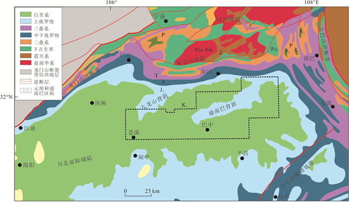
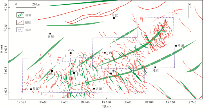
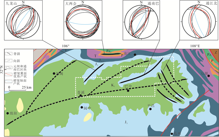
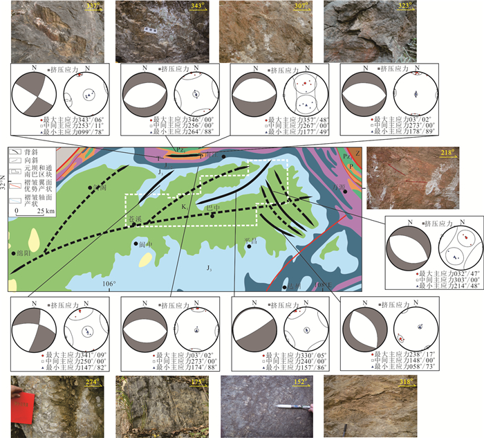
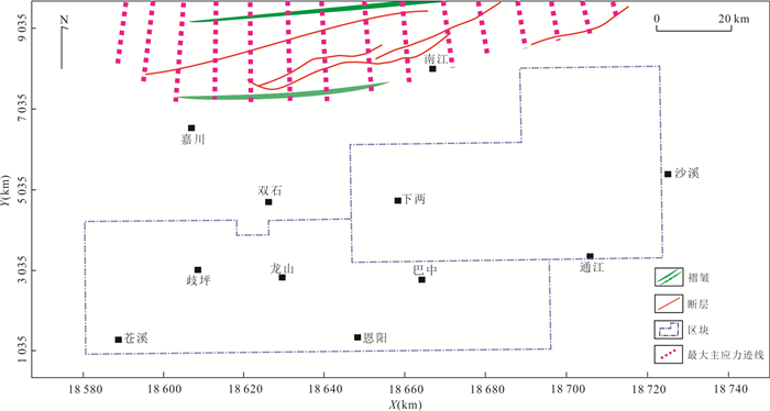
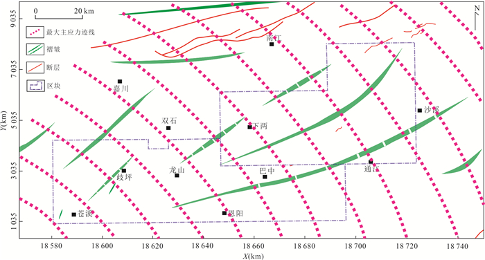
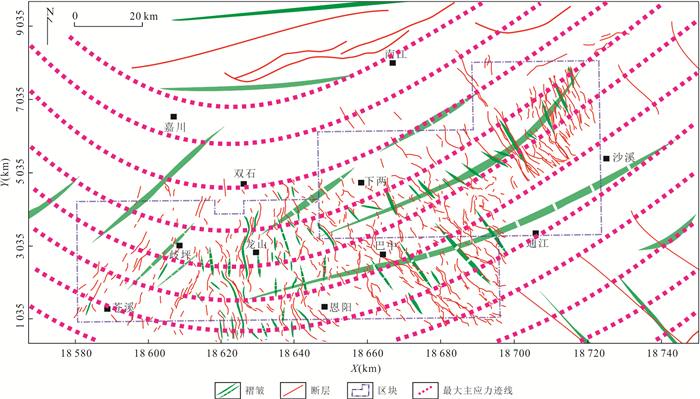
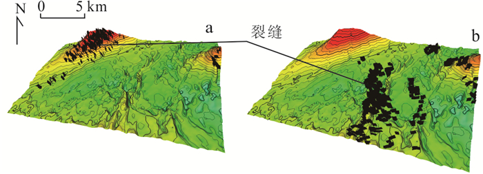
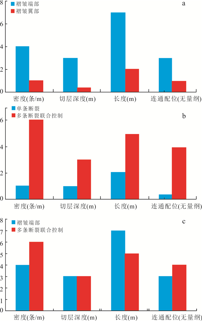
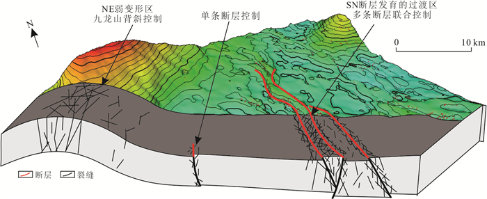
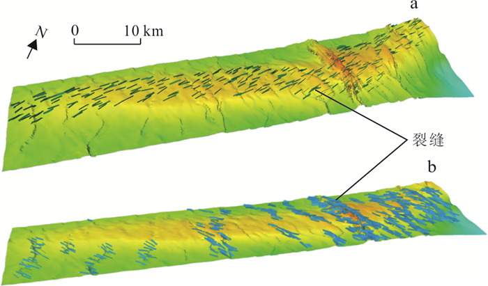
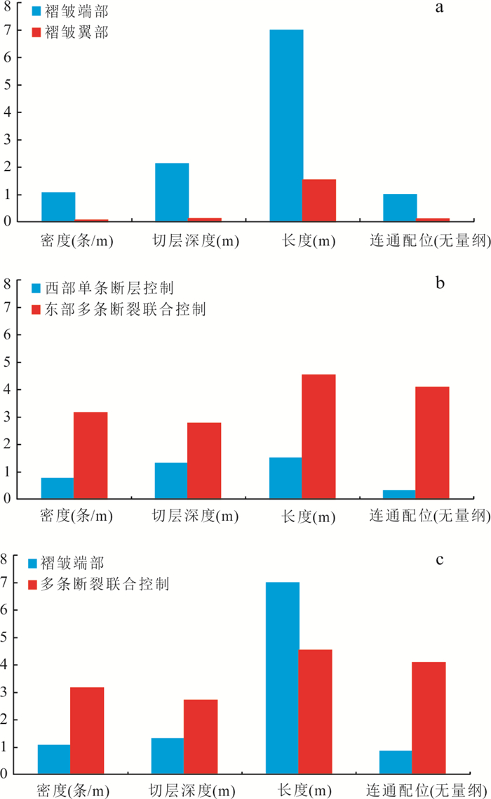
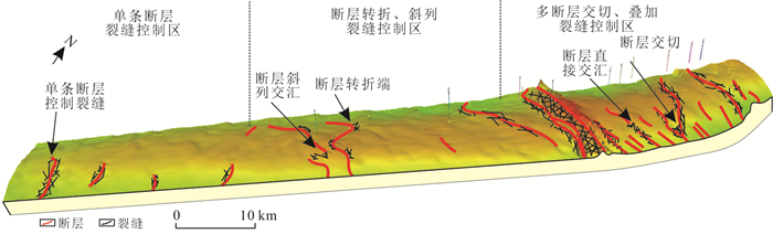
Tight sandstone reservoirs within tectonic intersection zones are shaped by multi-directional, polyphase stresses that generate fractures of variable density and scale. These structural overprints, superimposed on porosity variations from sedimentary and diagenetic processes, introduce strong heterogeneity, complicating reservoir characterization and prediction. Accurate delineation of fracture networks therefore requires systematic analysis of the geometry, evolution, and genetic mechanisms of intersection zones. By integrating field structural measurements with seismic interpretation, it constrained the spatial architecture of intersection zones and simulated fracture variability across subregions. Stochastic modeling under stress-field constraints captured directional deviations between individual fractures, reflecting the intrinsic randomness of natural systems. Results indicate that during the late Yanshanian, NW-SE directed compression dominated, producing NE-trending folds (Jiulongshan and Tongnanba anticlines) that exerted first-order control on fracture development. In contrast, Himalayan deformation was partitioned: NE-trending faults developed in the western Yuanba area, NS-trending faults in the central Yuanba, and NW-trending faults in the Tongnanba area. While Yanshanian folds primarily governed fracture distribution, Himalayan faults became the dominant control. From west to east, fracture intensity increases, with mechanisms evolving from single-fault control (Yuanba) to more complex fault bending, inflection, and enéchelon arrangements (western Tongnanba), culminating in dense fracture networks generated by intersecting faults in eastern Tongnanba.
Tight sandstone reservoirs within tectonic intersection zones are shaped by multi-directional, polyphase stresses that generate fractures of variable density and scale. These structural overprints, superimposed on porosity variations from sedimentary and diagenetic processes, introduce strong heterogeneity, complicating reservoir characterization and prediction. Accurate delineation of fracture networks therefore requires systematic analysis of the geometry, evolution, and genetic mechanisms of intersection zones. By integrating field structural measurements with seismic interpretation, it constrained the spatial architecture of intersection zones and simulated fracture variability across subregions. Stochastic modeling under stress-field constraints captured directional deviations between individual fractures, reflecting the intrinsic randomness of natural systems. Results indicate that during the late Yanshanian, NW-SE directed compression dominated, producing NE-trending folds (Jiulongshan and Tongnanba anticlines) that exerted first-order control on fracture development. In contrast, Himalayan deformation was partitioned: NE-trending faults developed in the western Yuanba area, NS-trending faults in the central Yuanba, and NW-trending faults in the Tongnanba area. While Yanshanian folds primarily governed fracture distribution, Himalayan faults became the dominant control. From west to east, fracture intensity increases, with mechanisms evolving from single-fault control (Yuanba) to more complex fault bending, inflection, and enéchelon arrangements (western Tongnanba), culminating in dense fracture networks generated by intersecting faults in eastern Tongnanba.
2026, 51(5): 1876-1892.
doi: 10.3799/dqkx.2026.107
Abstract:
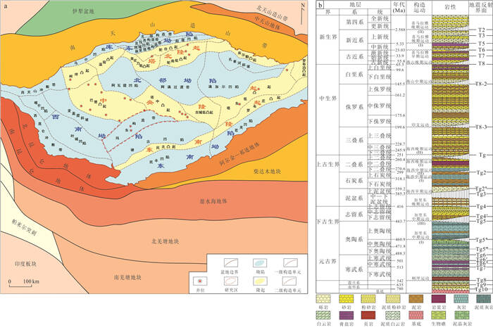
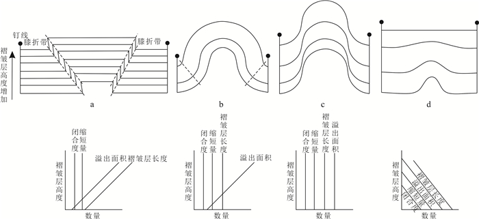
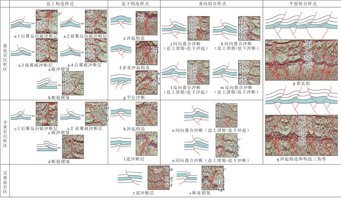
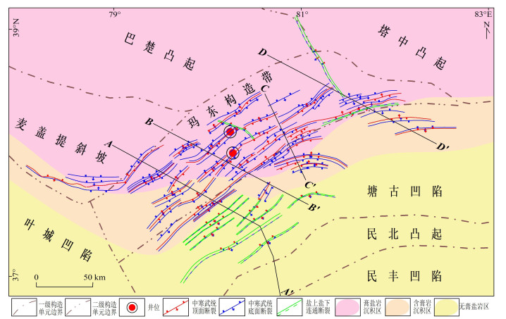
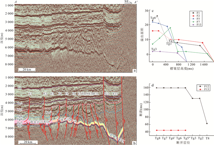
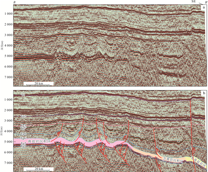
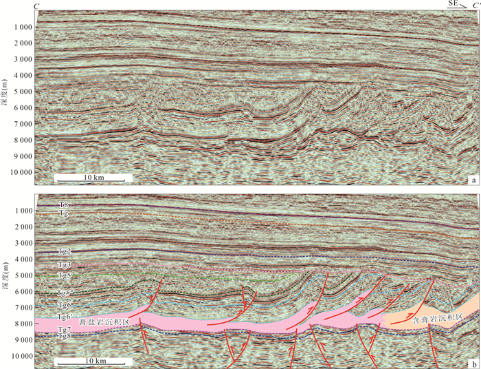
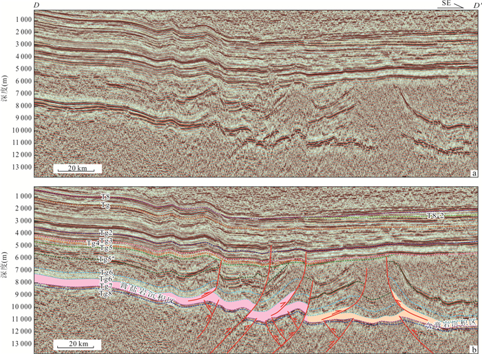
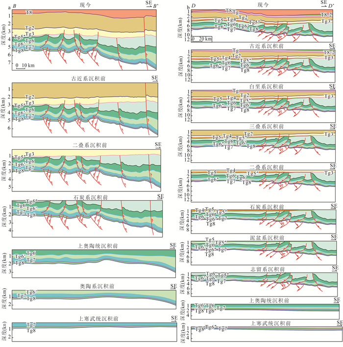
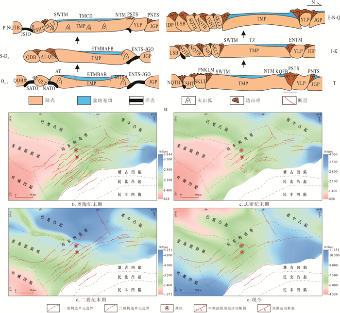
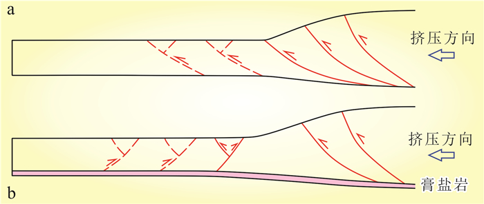
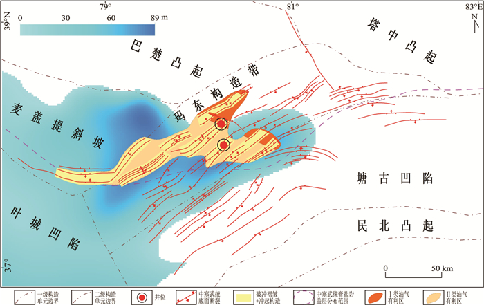
Madong structural belt in the Tarim basin is one of the best-preserved Early Paleozoic fold-thrust belts in the world. However, significant controversy persists regarding the characteristics and deformation mechanisms of Middle Cambrian salt-related structures due to complicate structures, which has constrained ultra-deep hydrocarbon exploration in the region. This study delineated the styles of salt-related structures based on 2D seismic data, determined their deformation phases and evolutionary sequence, established the response relationship between structural evolution and plate activities, discussed the deformation mechanisms, and predicted favorable sub-salt hydrocarbon targets. In the Madong structural belt, the post-salt strata predominantly developed hinterland-vergent break-thrust folds, while the sub-salt strata were dominated by basement-involved pop-up structures formed through shear folding (including flattening folding). The main deformation periods occurred at the end of the Ordovician and the Silurian, controlled by the amalgamation and collision of the Altun-Qilian Terrane and the Qaidam Block with the Tarim Plate. The Middle Cambrian gypsum-salt layer is one of the most critical driving factors for the formation of back-thrust faults in the belt. Shear folding can indirectly lead to the development of steeply dipping or vertical fractures, and the assemblage of "post-salt break-thrust folds and sub-salt pop-up structures" represents the most favorable exploration target for ultra-deep sub-salt strata.
Madong structural belt in the Tarim basin is one of the best-preserved Early Paleozoic fold-thrust belts in the world. However, significant controversy persists regarding the characteristics and deformation mechanisms of Middle Cambrian salt-related structures due to complicate structures, which has constrained ultra-deep hydrocarbon exploration in the region. This study delineated the styles of salt-related structures based on 2D seismic data, determined their deformation phases and evolutionary sequence, established the response relationship between structural evolution and plate activities, discussed the deformation mechanisms, and predicted favorable sub-salt hydrocarbon targets. In the Madong structural belt, the post-salt strata predominantly developed hinterland-vergent break-thrust folds, while the sub-salt strata were dominated by basement-involved pop-up structures formed through shear folding (including flattening folding). The main deformation periods occurred at the end of the Ordovician and the Silurian, controlled by the amalgamation and collision of the Altun-Qilian Terrane and the Qaidam Block with the Tarim Plate. The Middle Cambrian gypsum-salt layer is one of the most critical driving factors for the formation of back-thrust faults in the belt. Shear folding can indirectly lead to the development of steeply dipping or vertical fractures, and the assemblage of "post-salt break-thrust folds and sub-salt pop-up structures" represents the most favorable exploration target for ultra-deep sub-salt strata.

2026, 51(5): 1893-1907.
doi: 10.3799/dqkx.2025.298
Abstract:
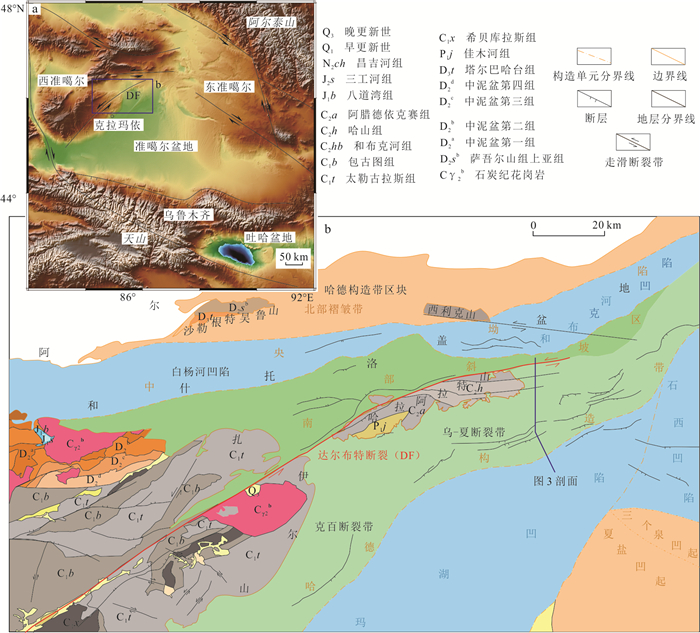
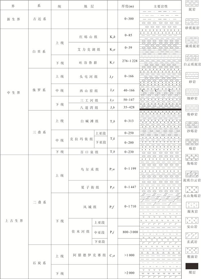
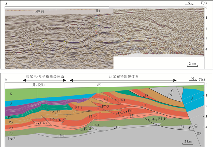
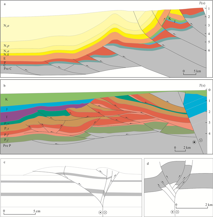
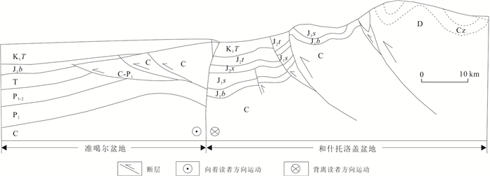
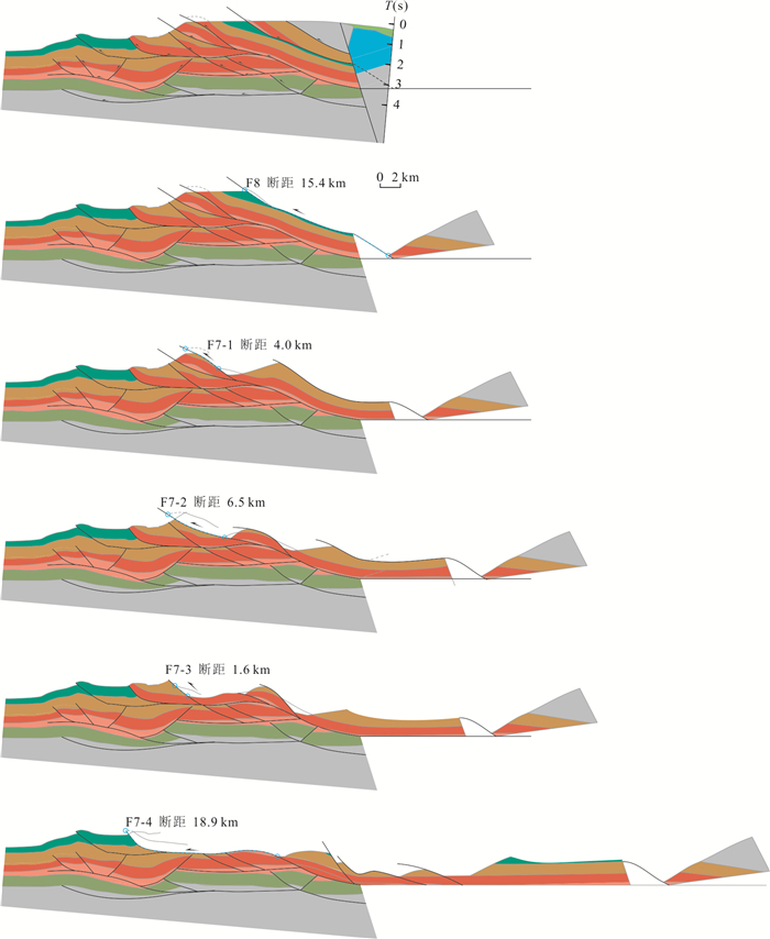
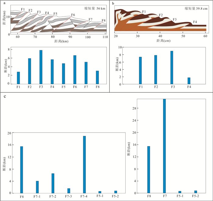
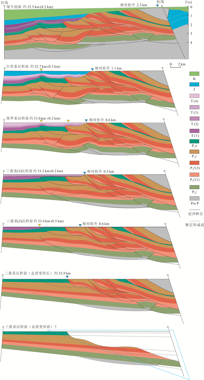
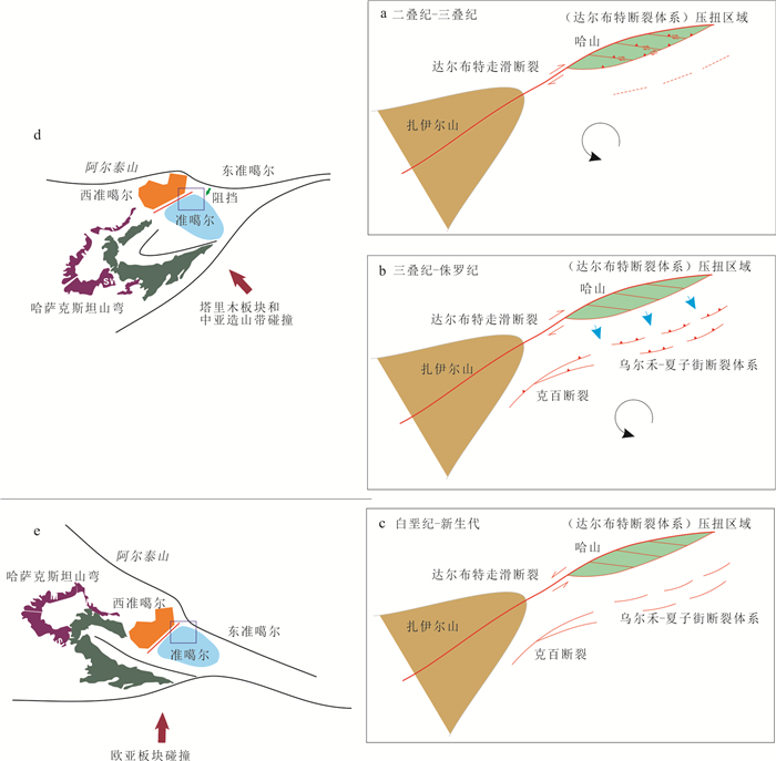
The fault property of the Hashan structural belt, located in the southwestern Junggar basin, is still controversial. In this paper it constructs the structural model of the Hashan structural belt by interpreting the latest seismic profile, and analyzes the fault displacements. The evolution process is investigated using balanced cross-section restoration. The results suggest that the Hashan structural belt is a complex fault system undergoing multiple stages of deformation. The Darabut fault system forms a typical flower structure controlled by the basement-involved strike-slip fault, and the Wuerhe-Xiazijie fault system develops a thrust deformation as the compressional stress propagates toward the Junggar basin. The Hashan structural belt has experienced three deformation stages since the Permian. The Darabut fault system predominantly formed in the Late Permian. The Wuerhe-Xiazijie fault system formed during the deformation from the Triassic to the Jurassic, and the Hashan structural belt kept lifting from the Cretaceous to the Cenozoic.
The fault property of the Hashan structural belt, located in the southwestern Junggar basin, is still controversial. In this paper it constructs the structural model of the Hashan structural belt by interpreting the latest seismic profile, and analyzes the fault displacements. The evolution process is investigated using balanced cross-section restoration. The results suggest that the Hashan structural belt is a complex fault system undergoing multiple stages of deformation. The Darabut fault system forms a typical flower structure controlled by the basement-involved strike-slip fault, and the Wuerhe-Xiazijie fault system develops a thrust deformation as the compressional stress propagates toward the Junggar basin. The Hashan structural belt has experienced three deformation stages since the Permian. The Darabut fault system predominantly formed in the Late Permian. The Wuerhe-Xiazijie fault system formed during the deformation from the Triassic to the Jurassic, and the Hashan structural belt kept lifting from the Cretaceous to the Cenozoic.
2026, 51(5): 1908-1923.
doi: 10.3799/dqkx.2026.163
Abstract:
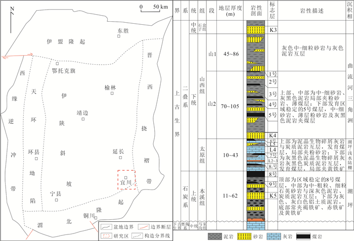
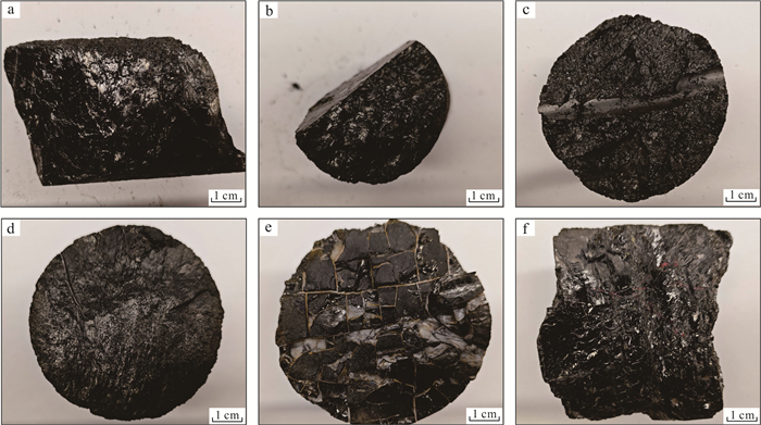
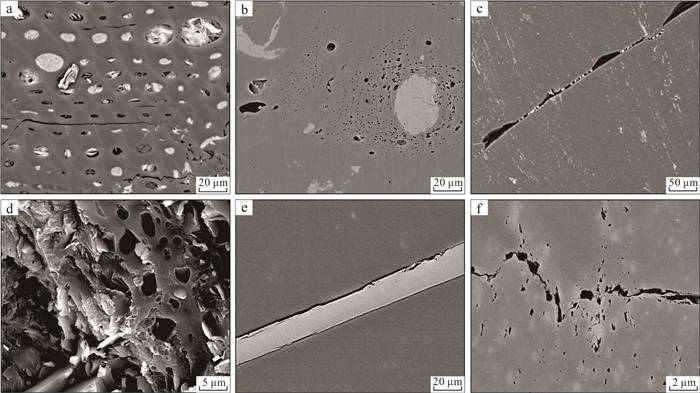
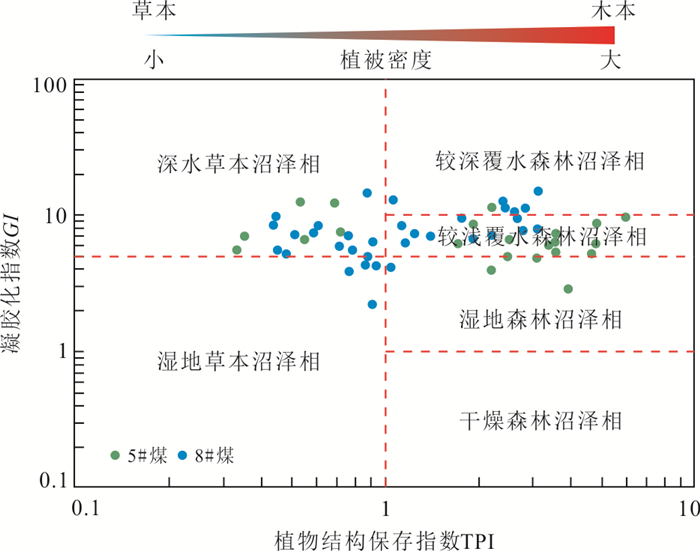
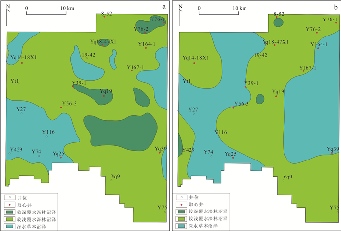
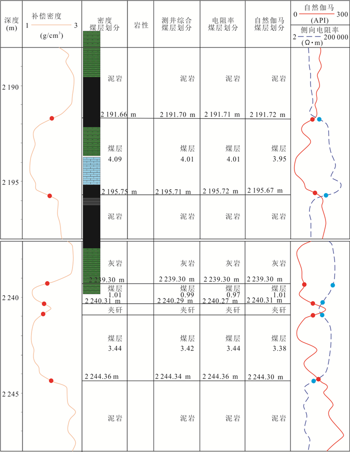
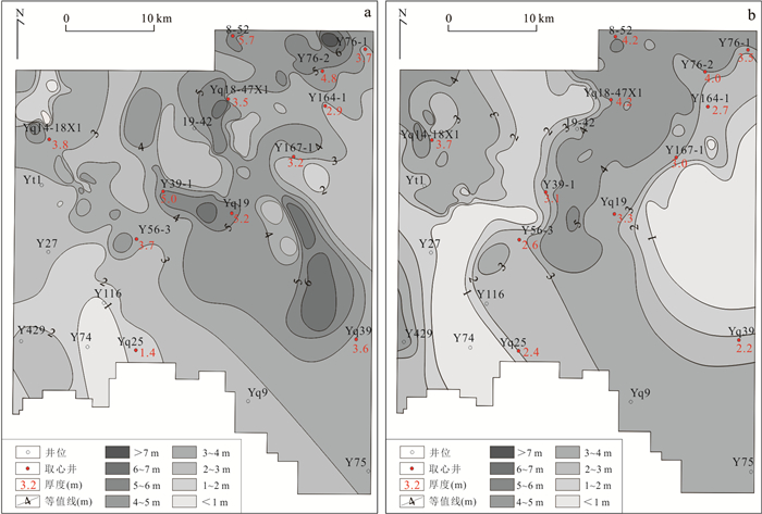
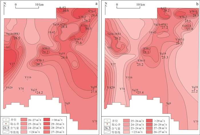
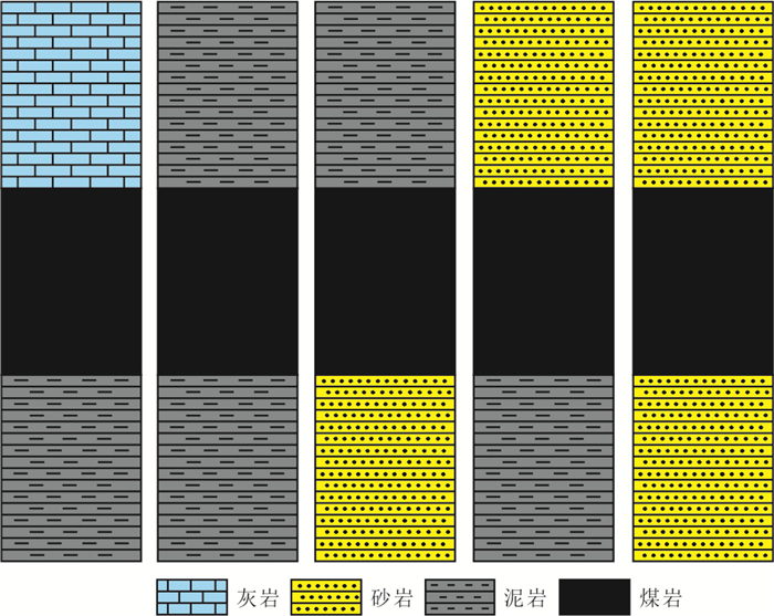
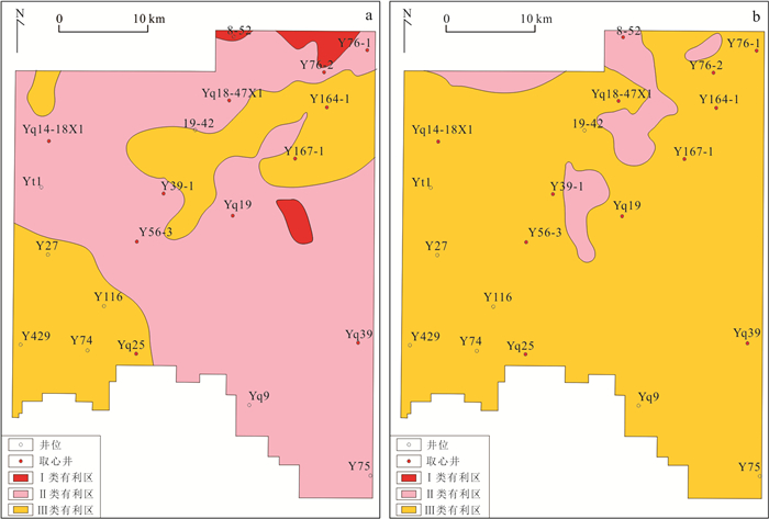
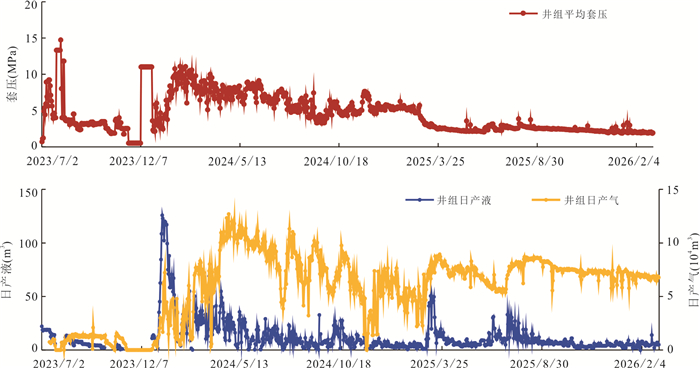
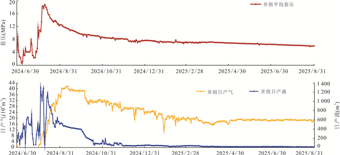
Coal seams are laterally stable in the Yichuan area, but generally thinner than those in the main body of the Ordos basin. However, the gas enrichment mechanisms and the geological characteristics of these thin seams are still to be fully elucidated, thereby constraining large-scale development. To bridge this gap, this study integrates core, well log, and laboratory data from the Benxi Formation No.8 coal seam and the Shanxi Formation No.5 coal seam to systematically evaluate the geological characteristics and primary controls on gas accumulation in these atypical thin seams. The results reveal follows. (1) The No.8 and No.5 coal seams exhibit elevated higher thermal maturity than those in the main basin, representing over-mature, high-rank coals with high vitrinite content and robust gas generation potential. The pore system is dominated by micropores, and cleats are highly developed. (2) The No.8 seam deposited in a tidal flat-lagoon environment, displays good continuity and stable thickness. In contrast, the No.5 coal seam formed in a delta front-coastal transitional environment, where its overall thickness is reduced due to the influence of sedimentary cycles and sandbody stacking. (3) The gas content of these coals is higher than the main basin. The average gas contents of the No.8 and No. 5 coal seams are 28.8 m3/t and 28.0 m3/t, respectively. The gas exists primarily in an adsorbed state, with free gas accounting for approximately 22%. (4) Based on geological and engineering parameters, evaluation criteria for Class Ⅰ, Ⅱ, and Ⅲ favorable areas were established. The No.8 coal seam is dominated by Class Ⅱ favorable area, whereas the No.5 coal seam is predominantly characterized by Class Ⅲ favorable area. Pilot production practices demonstrate that under conditions of high coal rank and high gas content, thin coal seams can also achieve high and stable yields through the application of horizontal drilling and stimulated reservoir volume fracturing technologies. The average daily gas production of the pilot horizontal wells exceeds 2×10⁴ m3. These findings demonstrate that coal seam thickness is not the determining constraint for coal seam gas development. The thin coal seams in the Yichuan area possess significant potential for large-scale development, providing an important reference for coal seam gas exploration in the Ordos basin and other analogous regions.
Coal seams are laterally stable in the Yichuan area, but generally thinner than those in the main body of the Ordos basin. However, the gas enrichment mechanisms and the geological characteristics of these thin seams are still to be fully elucidated, thereby constraining large-scale development. To bridge this gap, this study integrates core, well log, and laboratory data from the Benxi Formation No.8 coal seam and the Shanxi Formation No.5 coal seam to systematically evaluate the geological characteristics and primary controls on gas accumulation in these atypical thin seams. The results reveal follows. (1) The No.8 and No.5 coal seams exhibit elevated higher thermal maturity than those in the main basin, representing over-mature, high-rank coals with high vitrinite content and robust gas generation potential. The pore system is dominated by micropores, and cleats are highly developed. (2) The No.8 seam deposited in a tidal flat-lagoon environment, displays good continuity and stable thickness. In contrast, the No.5 coal seam formed in a delta front-coastal transitional environment, where its overall thickness is reduced due to the influence of sedimentary cycles and sandbody stacking. (3) The gas content of these coals is higher than the main basin. The average gas contents of the No.8 and No. 5 coal seams are 28.8 m3/t and 28.0 m3/t, respectively. The gas exists primarily in an adsorbed state, with free gas accounting for approximately 22%. (4) Based on geological and engineering parameters, evaluation criteria for Class Ⅰ, Ⅱ, and Ⅲ favorable areas were established. The No.8 coal seam is dominated by Class Ⅱ favorable area, whereas the No.5 coal seam is predominantly characterized by Class Ⅲ favorable area. Pilot production practices demonstrate that under conditions of high coal rank and high gas content, thin coal seams can also achieve high and stable yields through the application of horizontal drilling and stimulated reservoir volume fracturing technologies. The average daily gas production of the pilot horizontal wells exceeds 2×10⁴ m3. These findings demonstrate that coal seam thickness is not the determining constraint for coal seam gas development. The thin coal seams in the Yichuan area possess significant potential for large-scale development, providing an important reference for coal seam gas exploration in the Ordos basin and other analogous regions.
2026, 51(5): 1924-1946.
doi: 10.3799/dqkx.2026.103
Abstract:
To address the issues of inconsistent cross-regional stratigraphic division and weak integrated evaluation of deep and shallow petroleum systems in the South American POM transnational super basin, this study integrates drilling, seismic and experimental data, quantitatively analyzes the basin's tectono-sedimentary evolution and hydrocarbon accumulation elements, establishes hydrocarbon accumulation models and assesses resource quantities. Three evolutionary stages of the basin ("cratonic margin - rift - foreland") and the horizontal zonation characteristics of the three belts ("western thrust belt - central foredeep belt - eastern slope belt") are clarified; the shallow layer is a "mature and efficient type" petroleum system, dominated by two-stage charging and bidirectional migration, while the deep layer is an "underexplored potential type", characterized by single-stage charging and vertical migration. The undiscovered recoverable resources are predicted to be 7.01×10⁸-10.61×10⁸ t, and three types of favorable exploration areas are delineated, including the conventional oil and gas area in the western thrust belt, the conventional oil area in the western slope and foredeep belt, and the heavy oil area in the slope belt. A unified cross-regional tectono-sedimentary framework and differentiated deep-shallow hydrocarbon accumulation models are established, which provides key geological support for the exploration strategy of "tapping potential in shallow layers and achieving breakthroughs in deep layers" in the basin.
To address the issues of inconsistent cross-regional stratigraphic division and weak integrated evaluation of deep and shallow petroleum systems in the South American POM transnational super basin, this study integrates drilling, seismic and experimental data, quantitatively analyzes the basin's tectono-sedimentary evolution and hydrocarbon accumulation elements, establishes hydrocarbon accumulation models and assesses resource quantities. Three evolutionary stages of the basin ("cratonic margin - rift - foreland") and the horizontal zonation characteristics of the three belts ("western thrust belt - central foredeep belt - eastern slope belt") are clarified; the shallow layer is a "mature and efficient type" petroleum system, dominated by two-stage charging and bidirectional migration, while the deep layer is an "underexplored potential type", characterized by single-stage charging and vertical migration. The undiscovered recoverable resources are predicted to be 7.01×10⁸-10.61×10⁸ t, and three types of favorable exploration areas are delineated, including the conventional oil and gas area in the western thrust belt, the conventional oil area in the western slope and foredeep belt, and the heavy oil area in the slope belt. A unified cross-regional tectono-sedimentary framework and differentiated deep-shallow hydrocarbon accumulation models are established, which provides key geological support for the exploration strategy of "tapping potential in shallow layers and achieving breakthroughs in deep layers" in the basin.
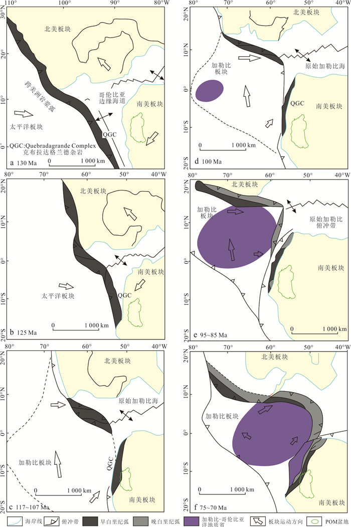
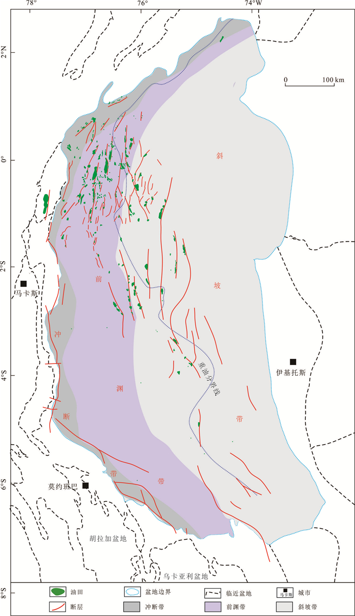
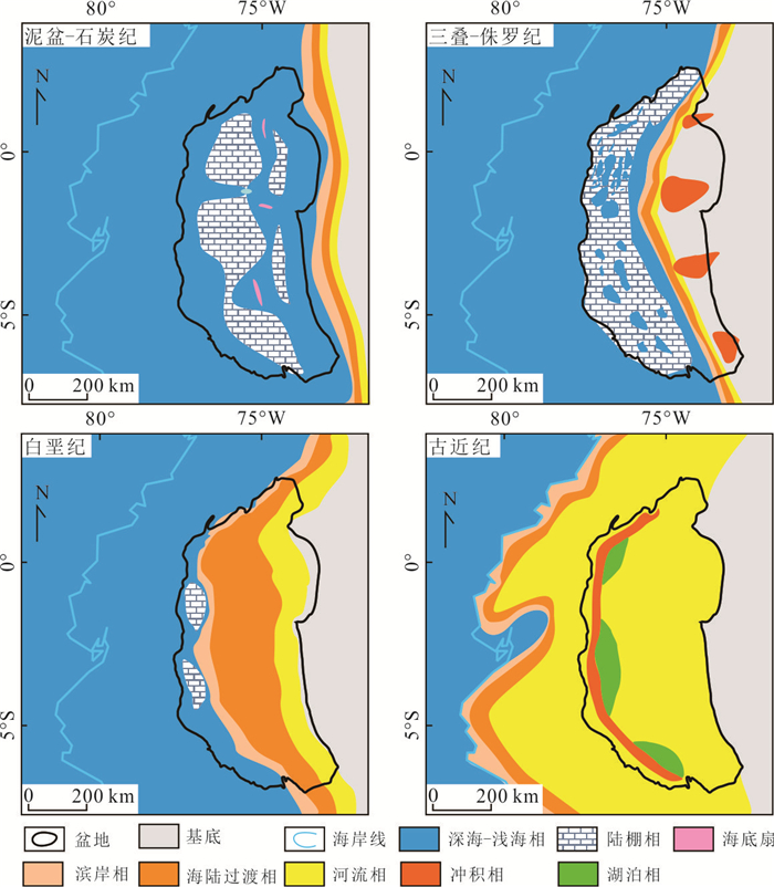
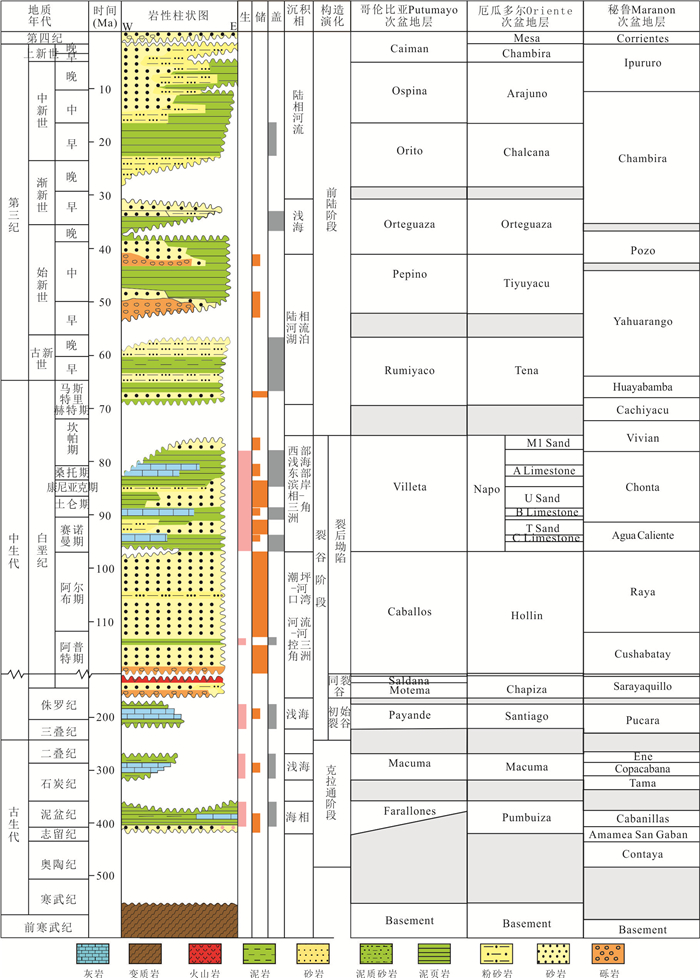
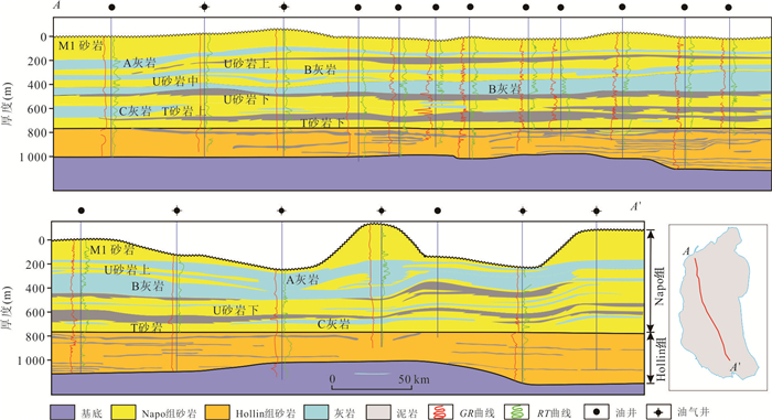
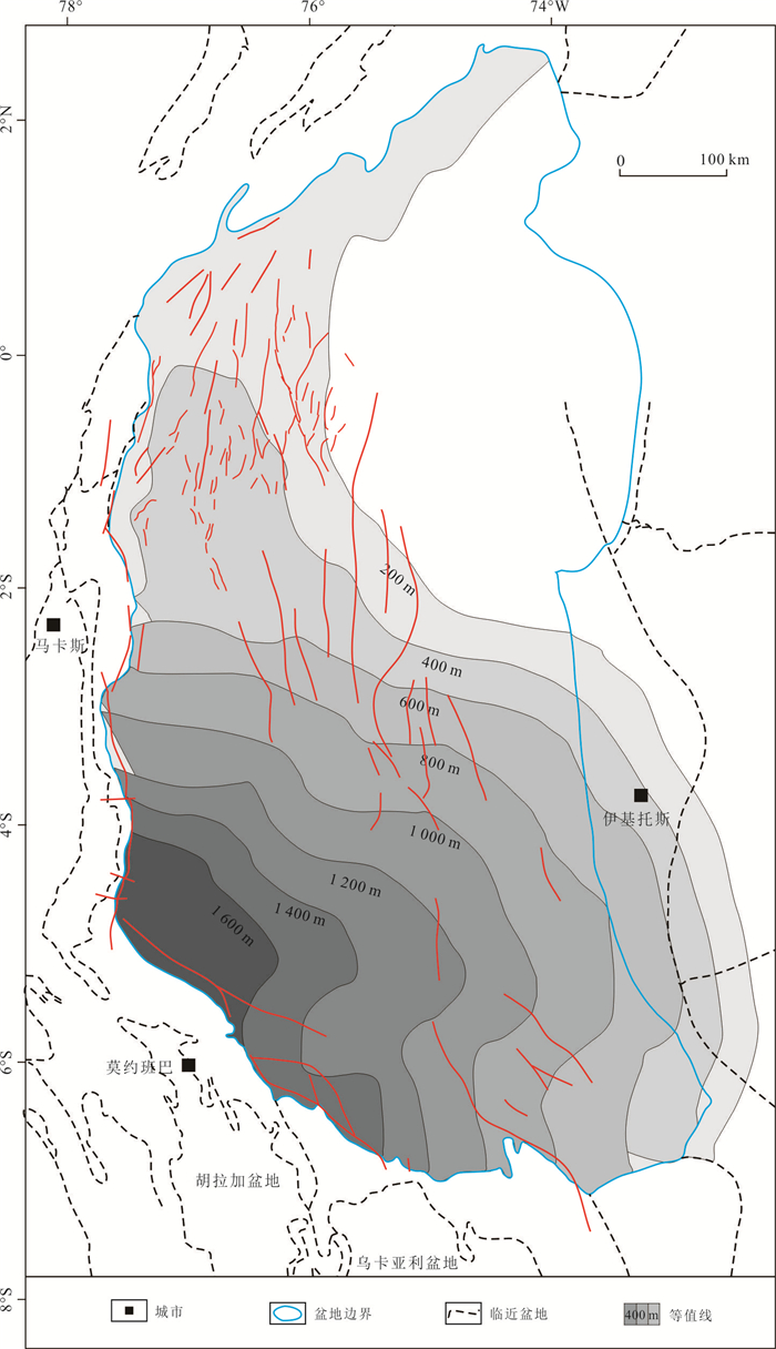
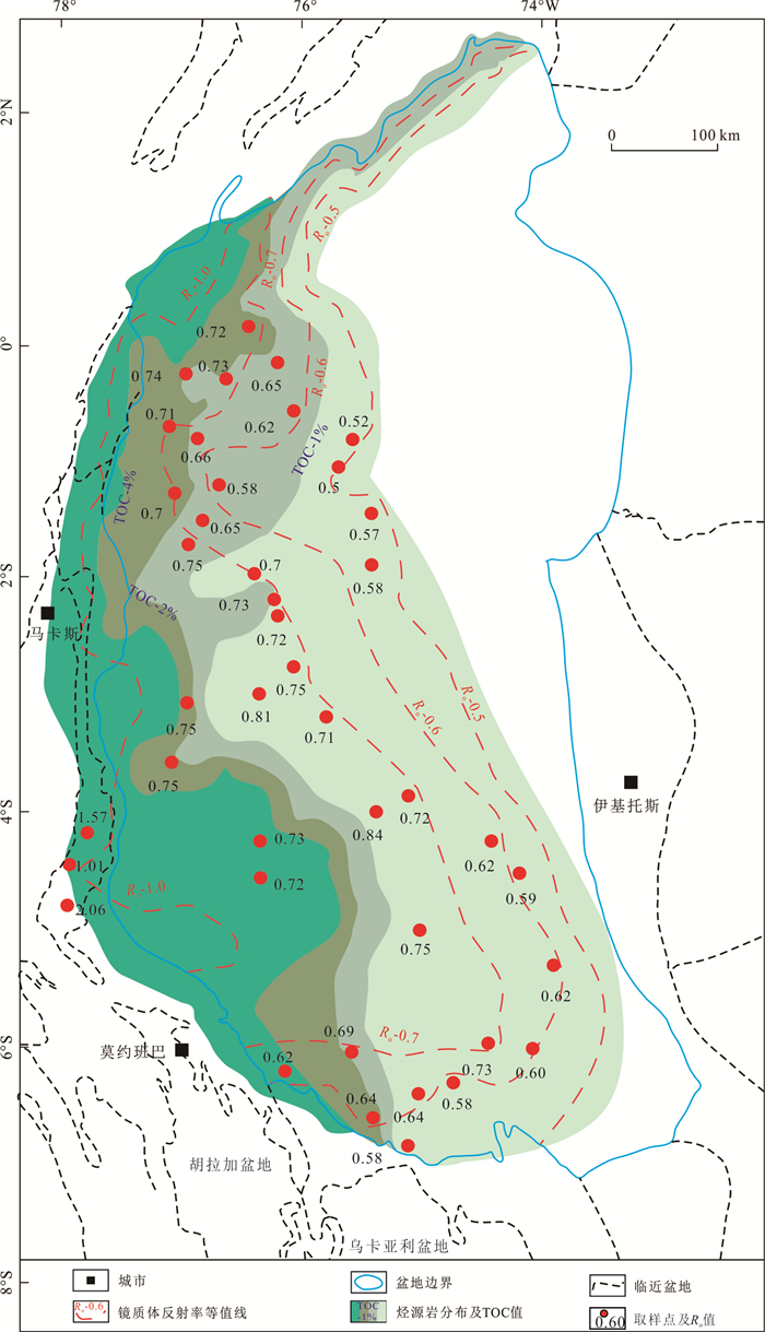
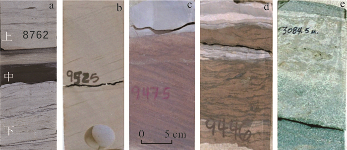
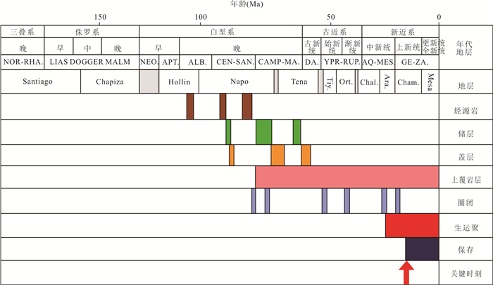
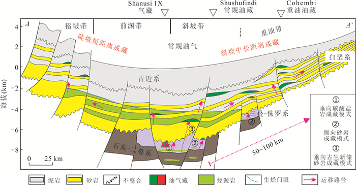
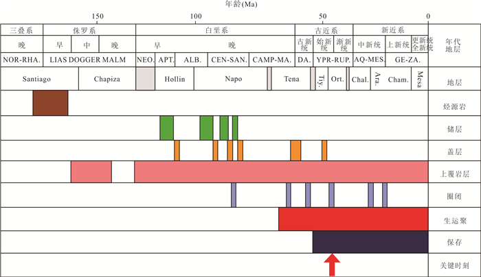
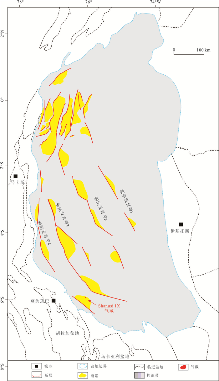
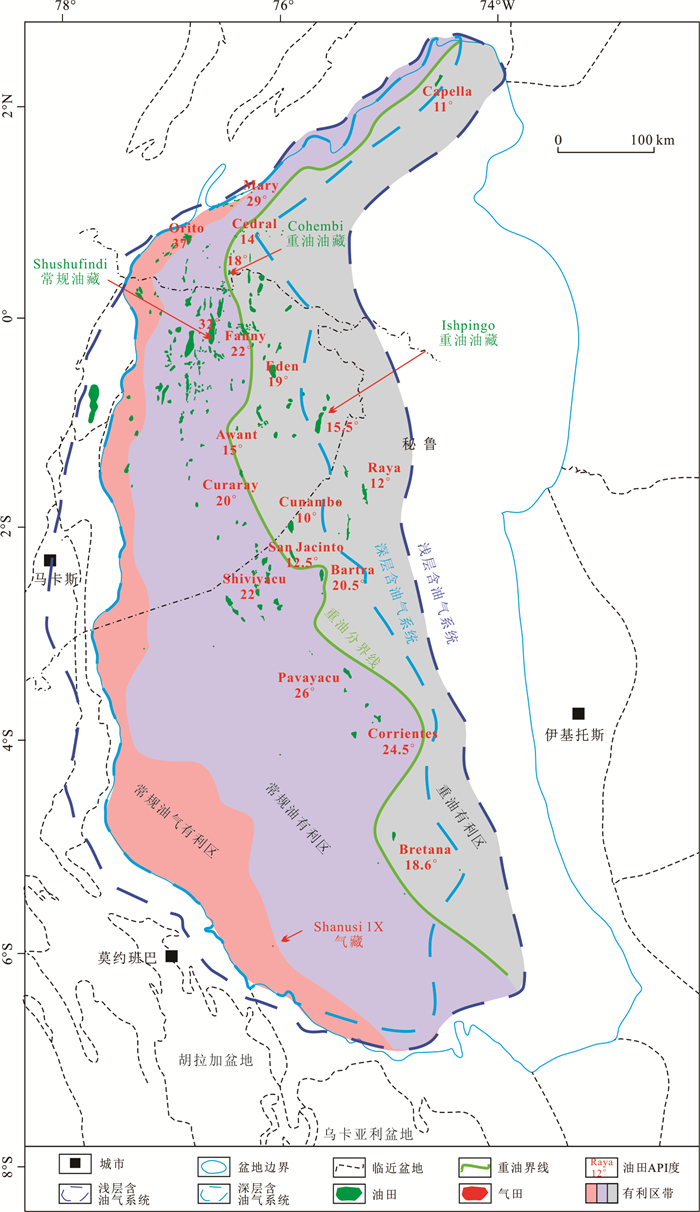
2026, 51(5): 1947-1964.
doi: 10.3799/dqkx.2026.081
Abstract:
The basin-mountain coupling theory has been widely recognized. However, it remains controversial in its interpretation for the basin-mountain systems in extensional regime. To unravel the basin-mountain coupling relationships under extensional regime, this study integrates field outcrops, borehole and seismic data, and geochemical and thermochronological data from the Jianghan basin and surrounding mountains, systematically clarifying their tectonic evolution. The surrounding mountains successively experienced rapid cooling, continued cooling, slow cooling and rapid cooling stages, and the Jianghan basin accordingly experienced compressional deformation, thermal doming, rifting and subsidence, and post-rift evolution. The upwelling of asthenospheric mantle not only drove the basin to undergo rifting and subsidence, but also delivered a large amount of deep composite materials to the basin. Our study proposes that the Jianghan basin became progressively deeper during the formation of the basin-mountain system, while the surrounding mountains got progressively lower and lower. The influence between the Jianghan basin and surrounding mountains is multi-faceted and single-directional. Their coupling model can be summarized as follows: (1) surrounding mountains shape the basin; (2) mountain exhumation results in basin filling; (3) the basin with increasing heat input transfers heat to surrounding mountains.
The basin-mountain coupling theory has been widely recognized. However, it remains controversial in its interpretation for the basin-mountain systems in extensional regime. To unravel the basin-mountain coupling relationships under extensional regime, this study integrates field outcrops, borehole and seismic data, and geochemical and thermochronological data from the Jianghan basin and surrounding mountains, systematically clarifying their tectonic evolution. The surrounding mountains successively experienced rapid cooling, continued cooling, slow cooling and rapid cooling stages, and the Jianghan basin accordingly experienced compressional deformation, thermal doming, rifting and subsidence, and post-rift evolution. The upwelling of asthenospheric mantle not only drove the basin to undergo rifting and subsidence, but also delivered a large amount of deep composite materials to the basin. Our study proposes that the Jianghan basin became progressively deeper during the formation of the basin-mountain system, while the surrounding mountains got progressively lower and lower. The influence between the Jianghan basin and surrounding mountains is multi-faceted and single-directional. Their coupling model can be summarized as follows: (1) surrounding mountains shape the basin; (2) mountain exhumation results in basin filling; (3) the basin with increasing heat input transfers heat to surrounding mountains.
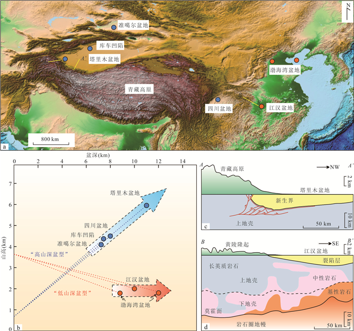
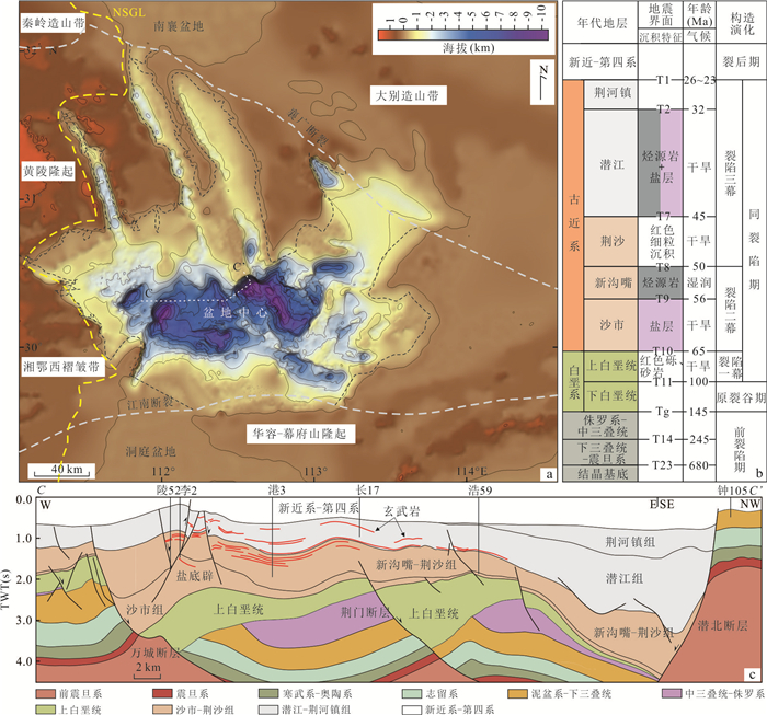
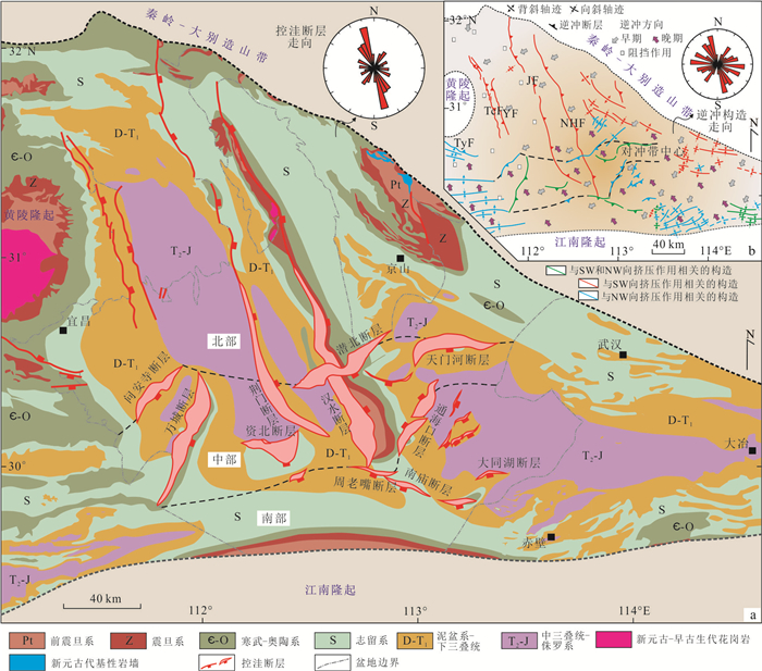
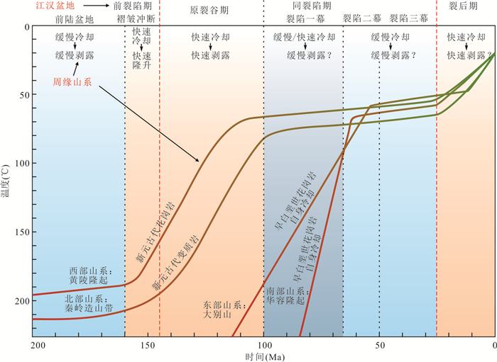
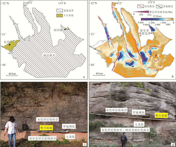
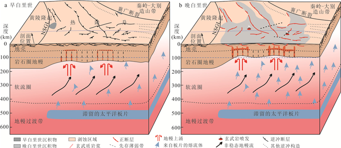
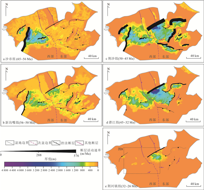
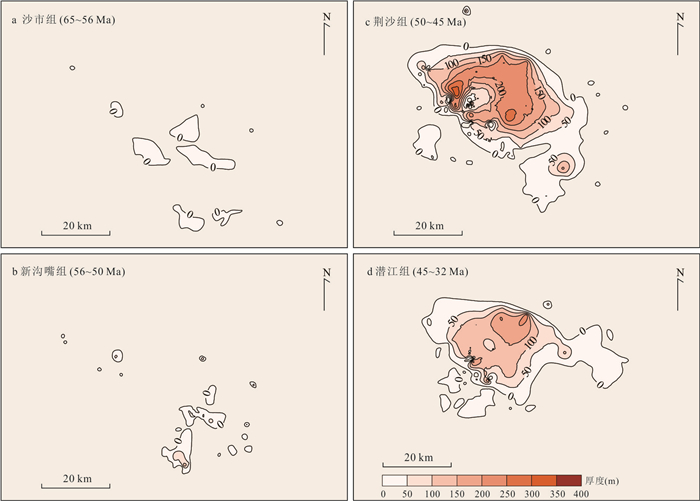
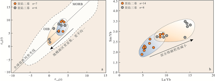
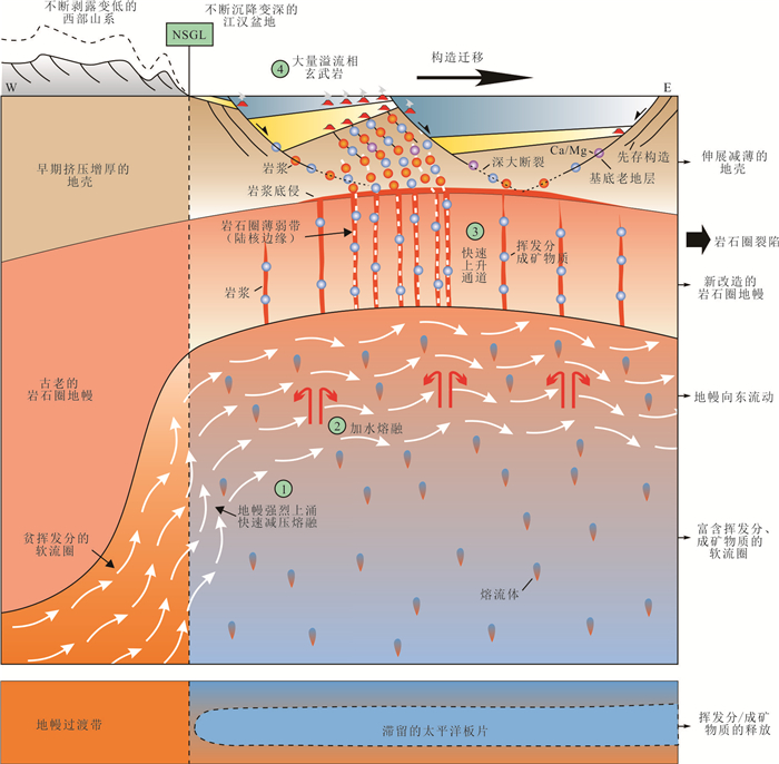
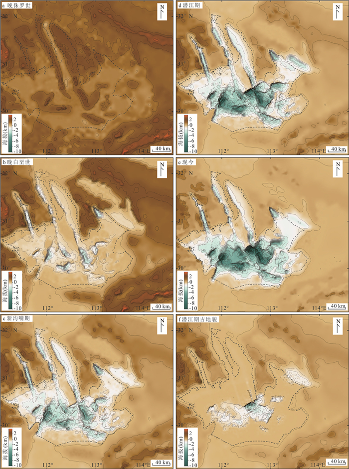
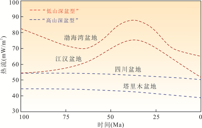
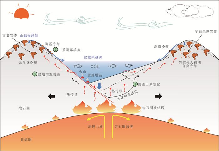
2026, 51(5): 1965-1981.
doi: 10.3799/dqkx.2025.251
Abstract:
In order to understand the different characteristics of the source-sink system of the first member of the Huangliu Formation in the eastern part of the Yinggehai basin, the provenance characteristics of coarse-grained and fine-grained sediments in the first member of Huangliu Formation in the eastern part of Yinggehai basin were quantitatively analyzed by means of mineralogy, zircon U-Pb chronology and Sr-Nd isotope analysis. The results show that the average source proportion of the Late Miocene coarse-grained sediments in the eastern part of Yinggehai Basin can reach about 65%, with that in central Vietnam at about 16%, and that in Hainan Island at about 19%. The average source of fine sediment is about 44% in Red River, about 37% in central Vietnam and about 19% in Hainan Island. Coarse-grained sediments have higher Red River provenance and less central Vietnam provenance than fine-grained sediments, presumably due to the rapid uplift of the Qinghai-Tibet Plateau and the reversal of the Red River fault zone in the Late Miocene. Furthermore, the differences in the characteristics of the source-sink systems of coarse-grained and fine-grained sediment are also influenced by the lower content of heavy minerals and the higher content of mud in the sediments.
In order to understand the different characteristics of the source-sink system of the first member of the Huangliu Formation in the eastern part of the Yinggehai basin, the provenance characteristics of coarse-grained and fine-grained sediments in the first member of Huangliu Formation in the eastern part of Yinggehai basin were quantitatively analyzed by means of mineralogy, zircon U-Pb chronology and Sr-Nd isotope analysis. The results show that the average source proportion of the Late Miocene coarse-grained sediments in the eastern part of Yinggehai Basin can reach about 65%, with that in central Vietnam at about 16%, and that in Hainan Island at about 19%. The average source of fine sediment is about 44% in Red River, about 37% in central Vietnam and about 19% in Hainan Island. Coarse-grained sediments have higher Red River provenance and less central Vietnam provenance than fine-grained sediments, presumably due to the rapid uplift of the Qinghai-Tibet Plateau and the reversal of the Red River fault zone in the Late Miocene. Furthermore, the differences in the characteristics of the source-sink systems of coarse-grained and fine-grained sediment are also influenced by the lower content of heavy minerals and the higher content of mud in the sediments.
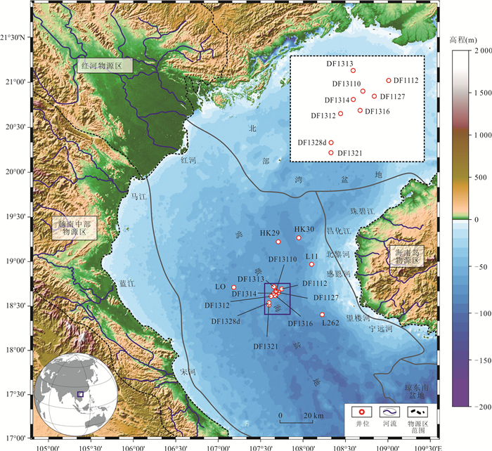
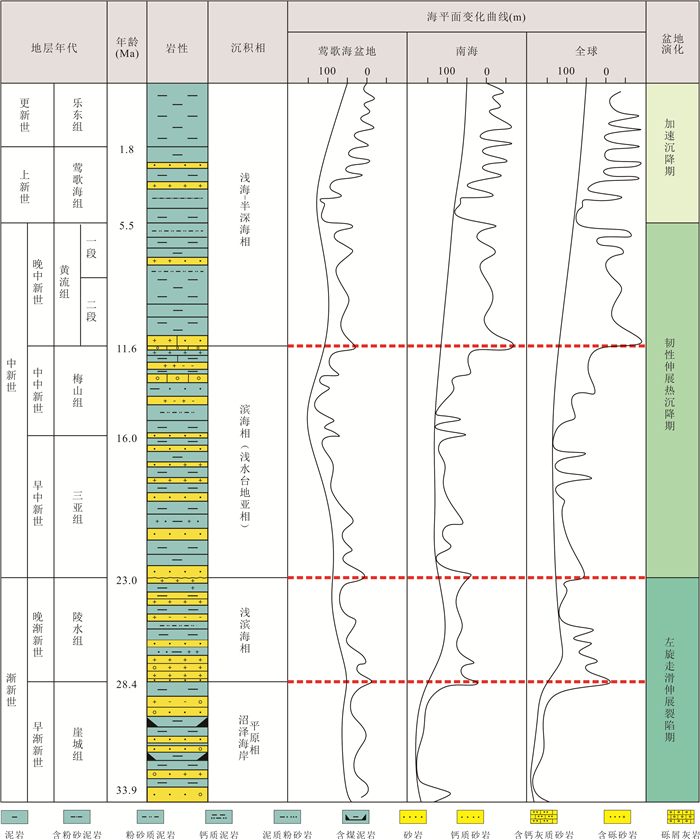
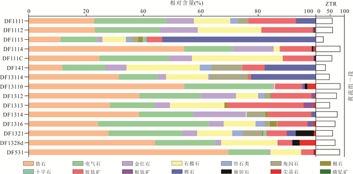
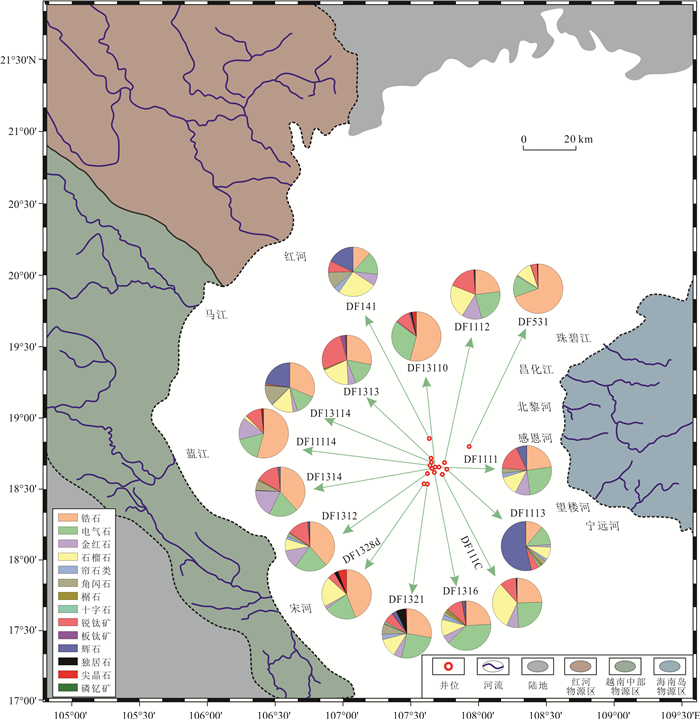
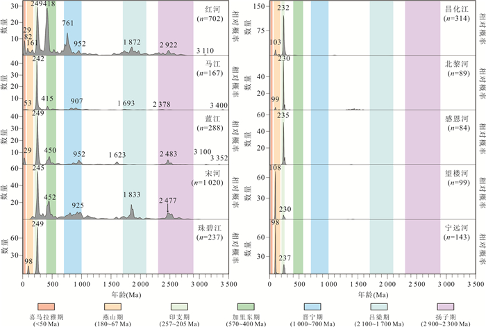
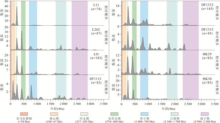
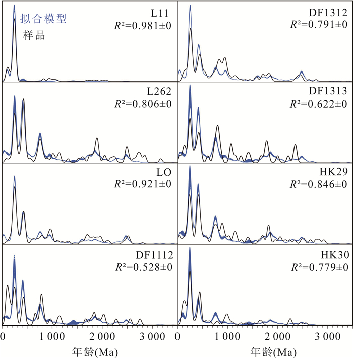
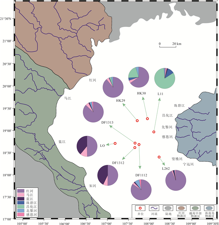
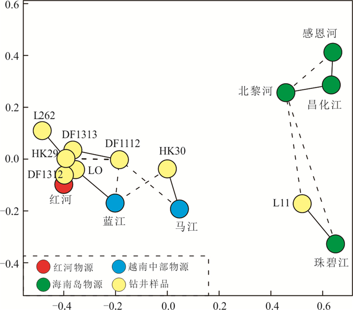
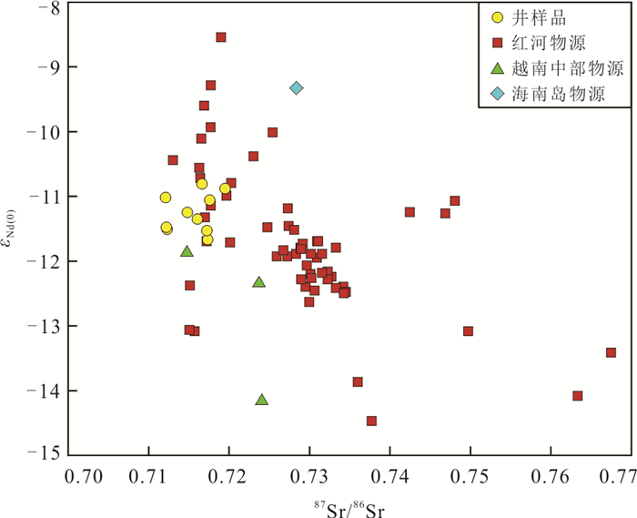
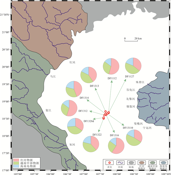
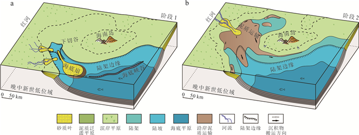
2026, 51(5): 1982-1996.
doi: 10.3799/dqkx.2026.160
Abstract:
The Baiyun sag is the forefront of deep-water oil and gas exploration in China. Due to the weak deep reflection signal of seismic data, local shallow gas shielding and trench influence, the deep architecture and structure of Paleogene are not clearly understood, which affects the process of oil and gas exploration. Based on this, the PSDM reprocessing of the unified seismic data in the whole sag was carried out. The new data basically eliminated the influence of shallow gas and trenches, as a result, the deep imaging was significantly improved, and the identifiable low-frequency events increased clearly. Based on the new seismic data, a comprehensive analysis of the deep key interface characteristics, tectonic layers, structural zoning and crustal rupture process was carried out. The study shows that there are four types of six regional unconformity interfaces developed from bottom to top before the sedimentary period of Zhujiang Formation. The Paleogene can be divided into five sets of structural layers from bottom to top. According to the difference of fault development mode and basement uplift position, Baiyun sag can be divided into three structural areas. According to the temporal and spatial evolution characteristics of the unconformity surface, seven tectonic episodes are divided (balanced extension episode, lower crust extension episode, lithosphere extension episode, three episodes of mantle exhumation in different directions and the drift episode that eventually forms the marginal sea). By analogy with the oil and gas accumulation conditions in Kaiping sag, it is speculated that the fourth member of Wenchang Formation developed in the lower crust extension period of Baiyun sag is the main source rock, which has important exploration prospects. The study reasonably explains the genesis of complex structures in Baiyun sag, provides a new structural framework for Paleogene tectonic evolution and sedimentary system migration and evolution, and also provides a new idea for the comparative study of other sags in the northern continental margin basin of the South China Sea, which is of great significance for deep-water oil and gas exploration.
The Baiyun sag is the forefront of deep-water oil and gas exploration in China. Due to the weak deep reflection signal of seismic data, local shallow gas shielding and trench influence, the deep architecture and structure of Paleogene are not clearly understood, which affects the process of oil and gas exploration. Based on this, the PSDM reprocessing of the unified seismic data in the whole sag was carried out. The new data basically eliminated the influence of shallow gas and trenches, as a result, the deep imaging was significantly improved, and the identifiable low-frequency events increased clearly. Based on the new seismic data, a comprehensive analysis of the deep key interface characteristics, tectonic layers, structural zoning and crustal rupture process was carried out. The study shows that there are four types of six regional unconformity interfaces developed from bottom to top before the sedimentary period of Zhujiang Formation. The Paleogene can be divided into five sets of structural layers from bottom to top. According to the difference of fault development mode and basement uplift position, Baiyun sag can be divided into three structural areas. According to the temporal and spatial evolution characteristics of the unconformity surface, seven tectonic episodes are divided (balanced extension episode, lower crust extension episode, lithosphere extension episode, three episodes of mantle exhumation in different directions and the drift episode that eventually forms the marginal sea). By analogy with the oil and gas accumulation conditions in Kaiping sag, it is speculated that the fourth member of Wenchang Formation developed in the lower crust extension period of Baiyun sag is the main source rock, which has important exploration prospects. The study reasonably explains the genesis of complex structures in Baiyun sag, provides a new structural framework for Paleogene tectonic evolution and sedimentary system migration and evolution, and also provides a new idea for the comparative study of other sags in the northern continental margin basin of the South China Sea, which is of great significance for deep-water oil and gas exploration.
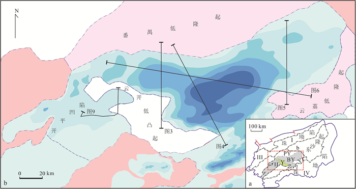
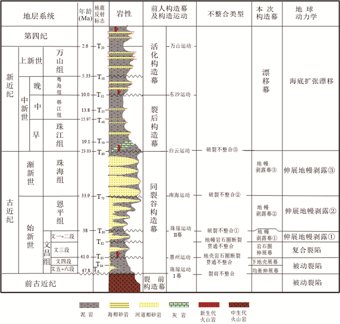
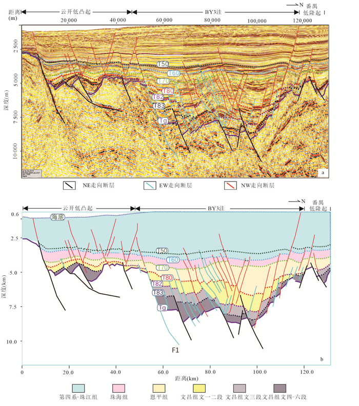
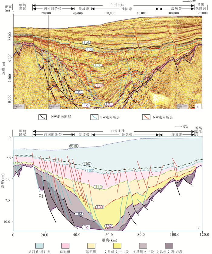
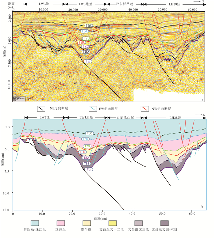
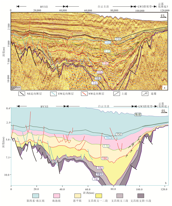
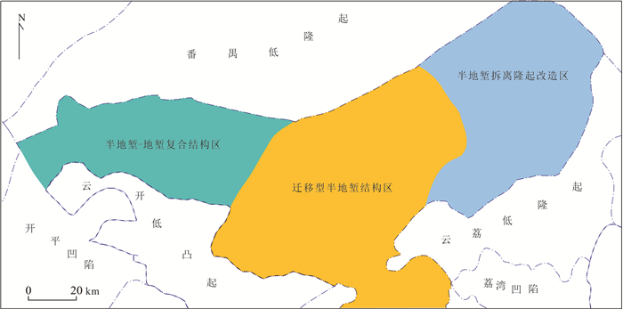
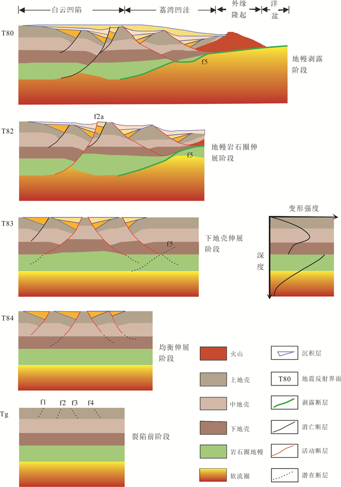
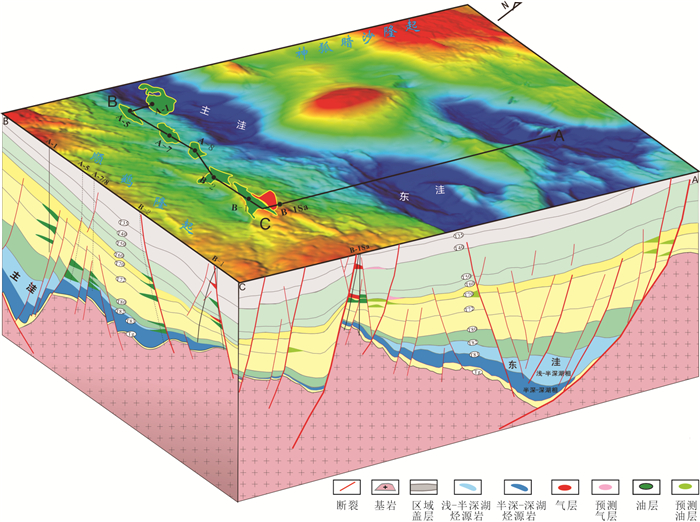
2026, 51(5): 1997-2010.
doi: 10.3799/dqkx.2026.124
Abstract:
Current understanding remains limited regarding the formation age, petrological composition, genetic mechanisms, and tectonic evolution of the granite encountered in the Baoyunting buried hill within the East China Sea basin. This study presents an integrated zircon U-Pb geochronological and petrogeochemical investigation on granites from two key exploration wells in the Baoyunting area. The objectives are to determine the petrogenesis and deep-seated geodynamic setting of these granites, and to further unravel their formation and evolution processes. Zircon LA-ICP-MS U-Pb dating reveals crystallization ages of 106.9-108.8 Ma for the Baoyunting granites, while the overlying pyroclastic rocks yield younger ages of 35.9-41.3 Ma. The granitic pluton primarily comprises granite and granodiorite, exhibiting geochemical affinities to high-Sr/Y granites or adakitic rocks. Combined petrological and geochemical evidence suggests that the Baoyunting granites originated from partial melting of basaltic rocks within a thickened lower crust during the Early Cretaceous. Integrating the results with regional multidisciplinary data, it proposes that these granites formed in a tectonic setting associated with the Paleo-Pacific Plate slab rollback during the late Early Cretaceous. The evolution of the Baoyunting granite buried hill involved three distinct stages: (1) pluton emplacement, (2) uplift-denudation, and (3) subsidence.
Current understanding remains limited regarding the formation age, petrological composition, genetic mechanisms, and tectonic evolution of the granite encountered in the Baoyunting buried hill within the East China Sea basin. This study presents an integrated zircon U-Pb geochronological and petrogeochemical investigation on granites from two key exploration wells in the Baoyunting area. The objectives are to determine the petrogenesis and deep-seated geodynamic setting of these granites, and to further unravel their formation and evolution processes. Zircon LA-ICP-MS U-Pb dating reveals crystallization ages of 106.9-108.8 Ma for the Baoyunting granites, while the overlying pyroclastic rocks yield younger ages of 35.9-41.3 Ma. The granitic pluton primarily comprises granite and granodiorite, exhibiting geochemical affinities to high-Sr/Y granites or adakitic rocks. Combined petrological and geochemical evidence suggests that the Baoyunting granites originated from partial melting of basaltic rocks within a thickened lower crust during the Early Cretaceous. Integrating the results with regional multidisciplinary data, it proposes that these granites formed in a tectonic setting associated with the Paleo-Pacific Plate slab rollback during the late Early Cretaceous. The evolution of the Baoyunting granite buried hill involved three distinct stages: (1) pluton emplacement, (2) uplift-denudation, and (3) subsidence.
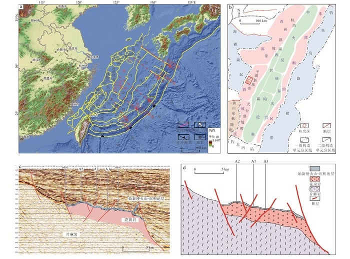
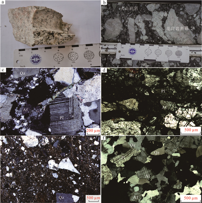
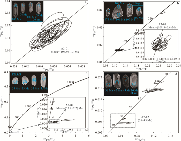
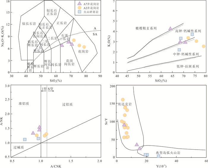
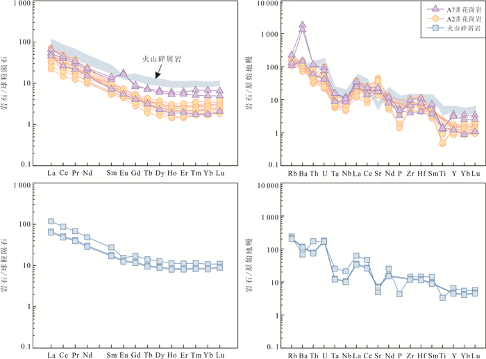
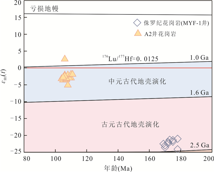
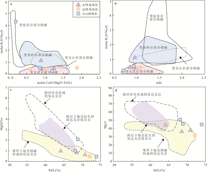
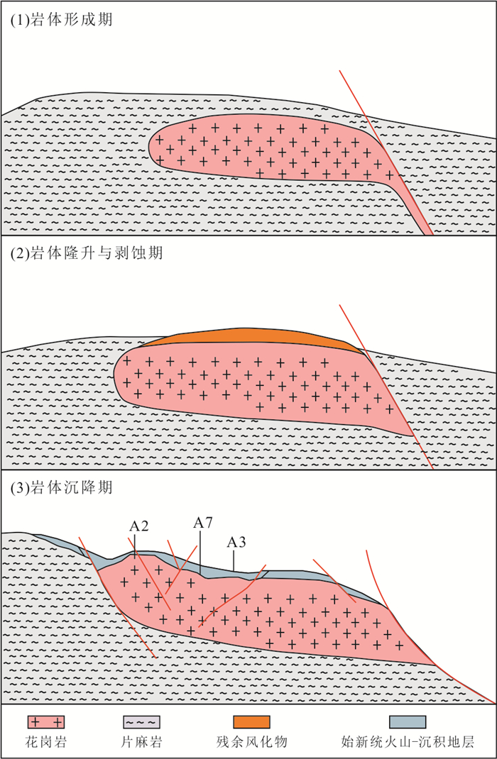
2026, 51(5): 2011-2023.
doi: 10.3799/dqkx.2026.055
Abstract:
The study of position-specific isotopes in natural gas propane is becoming a new hotspot in petroleum geochemistry. In this paper it summarizes advancements in analytical techniques for determining position-specific isotope compositions of propane in natural gas and examines the controlling mechanisms of position-specific isotope distributions in natural gases, which provides a novel means to trace hydrocarbon generation pathways, expulsion-retention processes and secondary alteration. By applying position-specific isotope signatures of propane desorbed from source rock, gas source correlation can be achieved, especially in basins with multiple adjacent source rock intervals. In summary, position-specific isotopes of propane provide a powerful tool for elucidating the formation, evolution, and alteration processes of natural gases. Further studies should integrate compound-specific isotope of alkane gases and clumped isotope of methane to extend its application to more complex geological systems.
The study of position-specific isotopes in natural gas propane is becoming a new hotspot in petroleum geochemistry. In this paper it summarizes advancements in analytical techniques for determining position-specific isotope compositions of propane in natural gas and examines the controlling mechanisms of position-specific isotope distributions in natural gases, which provides a novel means to trace hydrocarbon generation pathways, expulsion-retention processes and secondary alteration. By applying position-specific isotope signatures of propane desorbed from source rock, gas source correlation can be achieved, especially in basins with multiple adjacent source rock intervals. In summary, position-specific isotopes of propane provide a powerful tool for elucidating the formation, evolution, and alteration processes of natural gases. Further studies should integrate compound-specific isotope of alkane gases and clumped isotope of methane to extend its application to more complex geological systems.
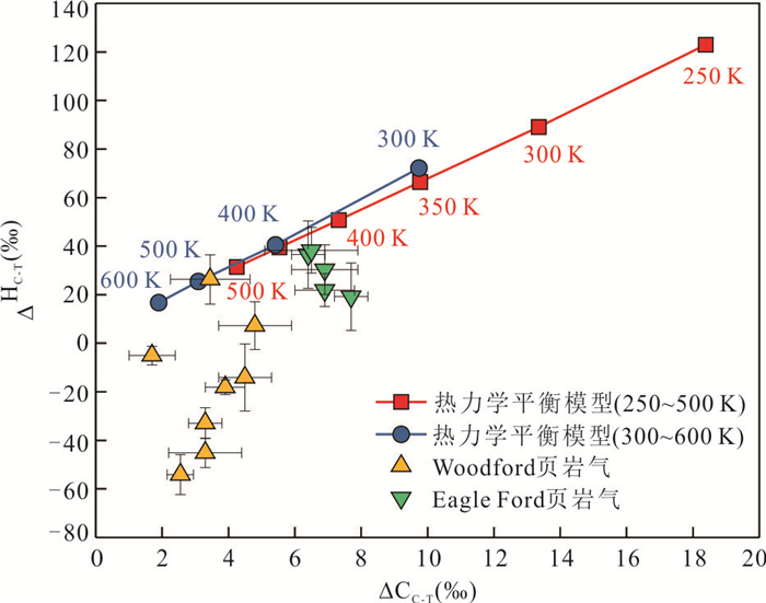
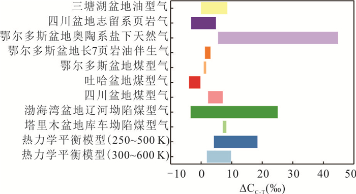
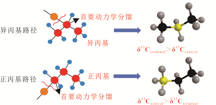
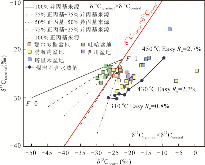
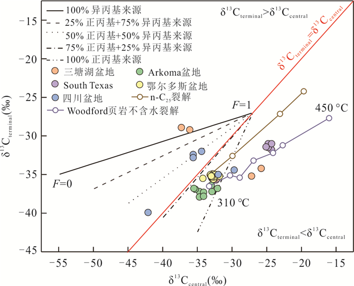
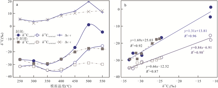
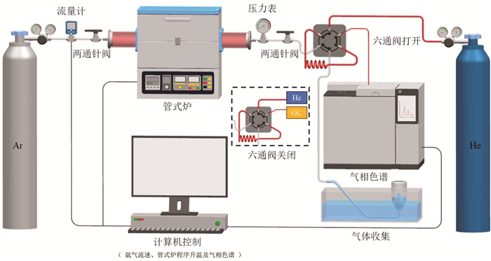
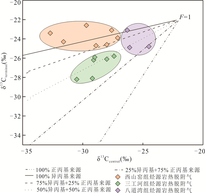
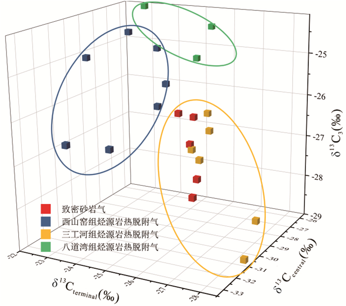
2026, 51(5): 2024-2046.
doi: 10.3799/dqkx.2026.111
Abstract:
Over the past decades, the target strata for sandstone-type uranium exploration in China have gradually shifted from early grayish-black uranium-bearing series to reddish-variegated uranium-bearing series. Due to the significant differences in the sedimentary paleoclimates in which these two types formed and developed, there is a substantial variation in the reducing capacity of the uranium-bearing series, which in turn fundamentally affects the scale of regional interlayer oxidation zones, directly restricting the prediction of prospective areas and prospecting targets. In light of this, in this paper, based on the study of uranium-bearing series in arid depositional backgrounds across multiple sedimentary basins, and using uranium-bearing series with warm and humid depositional background as a reference, it systematically summarizes the basic characteristics and uranium mineralization patterns of reddish-variegated uranium-bearing series, and proposes key scientific issues and exploration prediction suggestions. The study suggests that sedimentary paleoclimate, through its coupling with the paleoenvironment, directly affects the abundance of organic reducing media in uranium-bearing series, thus restricting uranium mineralization. Therefore, it is necessary to classify uranium-bearing rock series into two extreme types: grayish-black and reddish-variegated, based on sedimentary paleoclimate and paleoenvironment. The two extreme types of uranium-bearing series are fundamentally different. The reddish-variegated uranium-bearing series has two important characteristics that restrict uranium mineralization: firstly, an overall lack of organic reducing media, with low contents of TOC, Stotal, and FeO; secondly, more complex and diverse lithogeochemical types of uranium reservoir sand bodies. Owing to the lack of organic reducing media, inorganic reducing media in uranium reservoirs play a significant role in uranium mineralization, and their genetic evolution and distribution patterns are well-documented. Furthermore, external reducing media formed by sedimentary facies changes can compensate for insufficient internal reducing capacity and play a decisive role in the spatial positioning of regional interlayer oxidation zones and uranium mineralization-sedimentary facies changes preferentially control mineralization. The epigenetic oxidation alteration of the reddish-variegated uranium-bearing series appears "weak", mainly manifested as banded, spotted, and grayish-white oxidation. Being large in scale, the oxidation zones are a superposition of secondary and primary oxidation, and often extend into the hinterland of the basin. The reddish-variegated uranium-bearing series belongs to a new type of uranium-bearing series, and there is an urgent need to explore the ore-controlling mechanism of inorganic reducing media, establish environmental parameter standards for evaluating inorganic reducing media, and summarize the identification marks of primary and epigenetic oxidation. In uranium exploration and prediction, it is not only necessary to accurately locate the integral gray reducing geological body and correctly identify the "weak" oxidation zone, but also to break with convention and enter the hinterland of the basin to carry out prediction and evaluation.
Over the past decades, the target strata for sandstone-type uranium exploration in China have gradually shifted from early grayish-black uranium-bearing series to reddish-variegated uranium-bearing series. Due to the significant differences in the sedimentary paleoclimates in which these two types formed and developed, there is a substantial variation in the reducing capacity of the uranium-bearing series, which in turn fundamentally affects the scale of regional interlayer oxidation zones, directly restricting the prediction of prospective areas and prospecting targets. In light of this, in this paper, based on the study of uranium-bearing series in arid depositional backgrounds across multiple sedimentary basins, and using uranium-bearing series with warm and humid depositional background as a reference, it systematically summarizes the basic characteristics and uranium mineralization patterns of reddish-variegated uranium-bearing series, and proposes key scientific issues and exploration prediction suggestions. The study suggests that sedimentary paleoclimate, through its coupling with the paleoenvironment, directly affects the abundance of organic reducing media in uranium-bearing series, thus restricting uranium mineralization. Therefore, it is necessary to classify uranium-bearing rock series into two extreme types: grayish-black and reddish-variegated, based on sedimentary paleoclimate and paleoenvironment. The two extreme types of uranium-bearing series are fundamentally different. The reddish-variegated uranium-bearing series has two important characteristics that restrict uranium mineralization: firstly, an overall lack of organic reducing media, with low contents of TOC, Stotal, and FeO; secondly, more complex and diverse lithogeochemical types of uranium reservoir sand bodies. Owing to the lack of organic reducing media, inorganic reducing media in uranium reservoirs play a significant role in uranium mineralization, and their genetic evolution and distribution patterns are well-documented. Furthermore, external reducing media formed by sedimentary facies changes can compensate for insufficient internal reducing capacity and play a decisive role in the spatial positioning of regional interlayer oxidation zones and uranium mineralization-sedimentary facies changes preferentially control mineralization. The epigenetic oxidation alteration of the reddish-variegated uranium-bearing series appears "weak", mainly manifested as banded, spotted, and grayish-white oxidation. Being large in scale, the oxidation zones are a superposition of secondary and primary oxidation, and often extend into the hinterland of the basin. The reddish-variegated uranium-bearing series belongs to a new type of uranium-bearing series, and there is an urgent need to explore the ore-controlling mechanism of inorganic reducing media, establish environmental parameter standards for evaluating inorganic reducing media, and summarize the identification marks of primary and epigenetic oxidation. In uranium exploration and prediction, it is not only necessary to accurately locate the integral gray reducing geological body and correctly identify the "weak" oxidation zone, but also to break with convention and enter the hinterland of the basin to carry out prediction and evaluation.