2026 Vol. 51, No. 6
 PDF 3985KB
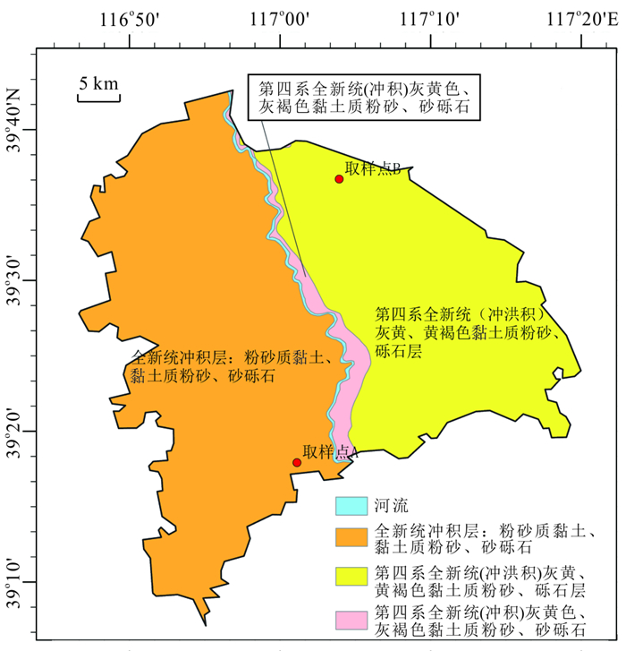
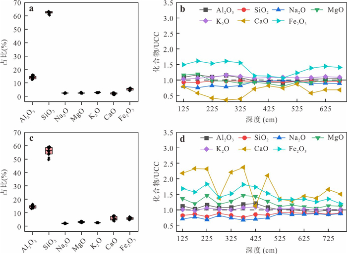
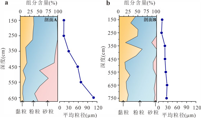
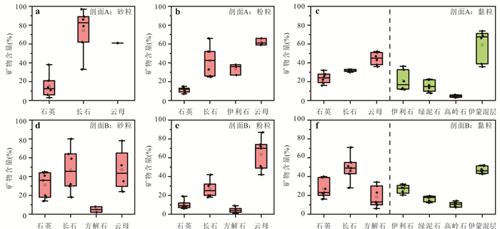
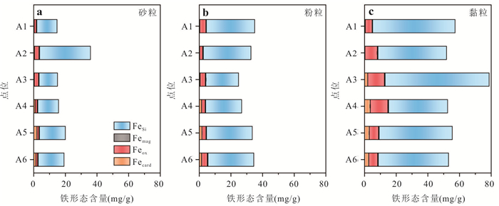
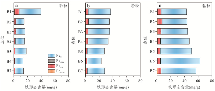
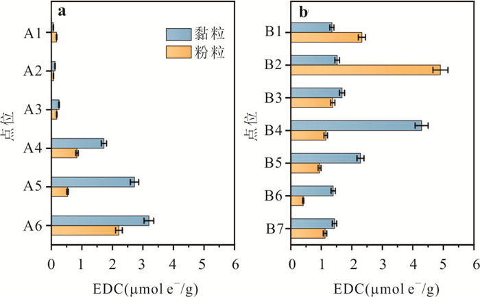
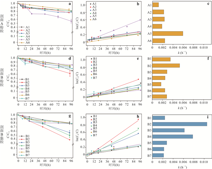
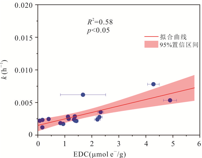
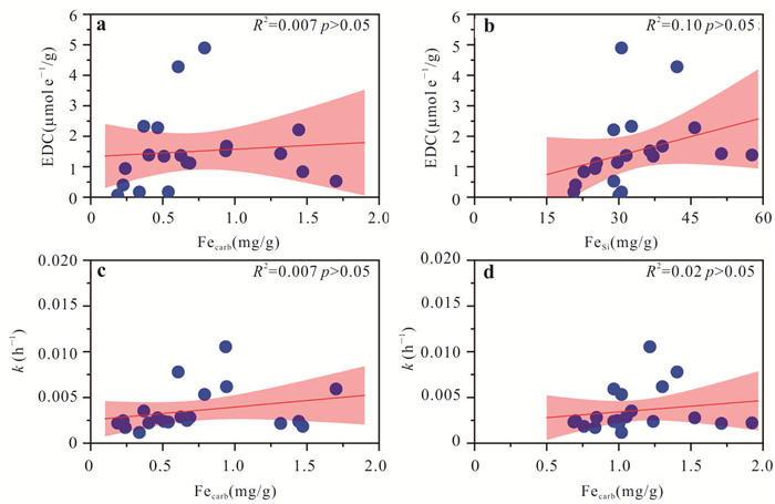
To explore the relationships among mineral distribution in sediments, their reducing capacity, and the abiotic reduction rate of organic pollutants in groundwater, this study utilized two sets of typical columnar sediment cores. A systematic investigation of sediments was conducted, including particle size composition, mineral distribution, iron speciation, electron-donating capacity (EDC), and abiotic reduction rate of nitrobenzene induced by sediment. Results show that the predominant minerals in sediments varied with sediment particle size, with clay minerals such as illite primarily concentrated in the clay fractions. Clay fractions exhibited a higher EDC than silt fractions, and presented a faster abiotic reduction rate for nitrobenzene. Moreover, EDC not only can serve as a quantitative measure of sediment reducing capacity, but also can act as a valuable indicator for assessing the potential for abiotic reduction of nitrobenzene by sediments. These findings provide a new perspective for predicting the abiotic natural reduction capacity of sediments and groundwater organic contaminant remediation.
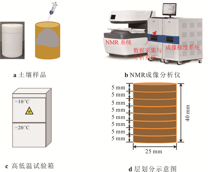
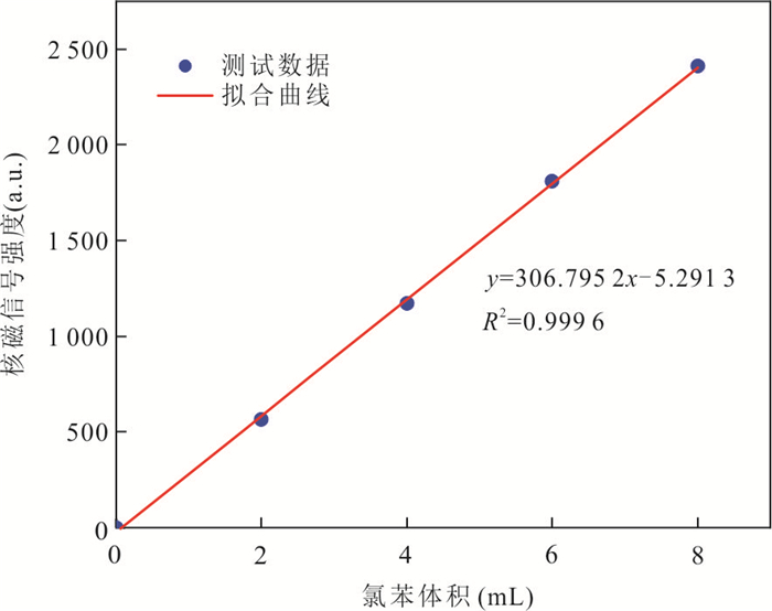
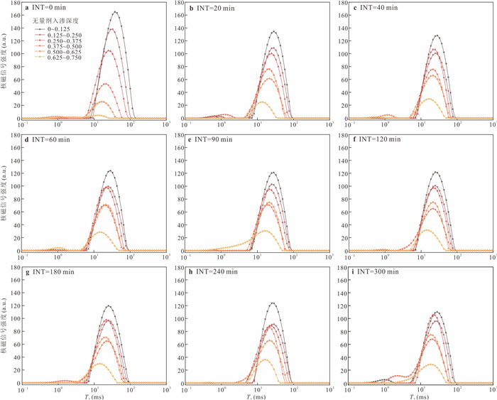
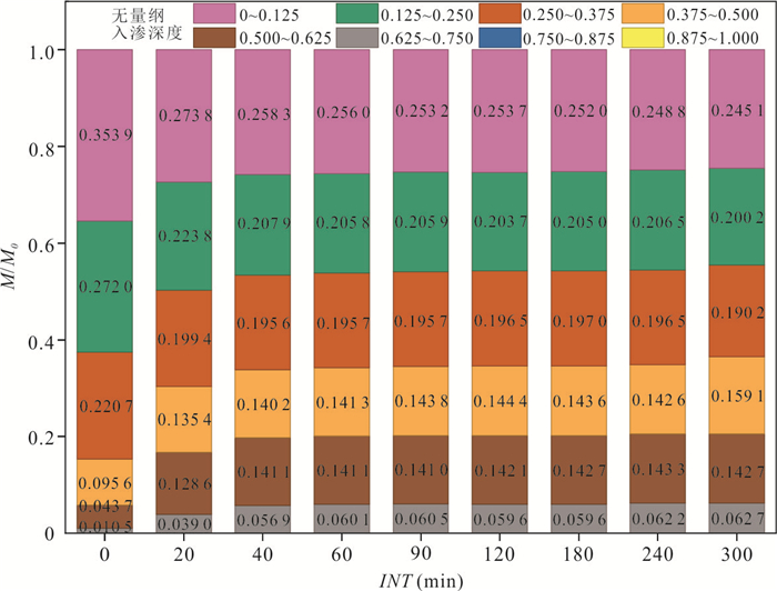
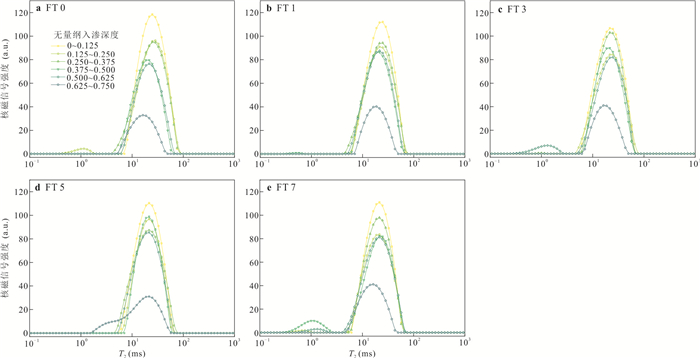
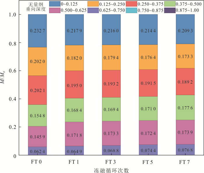
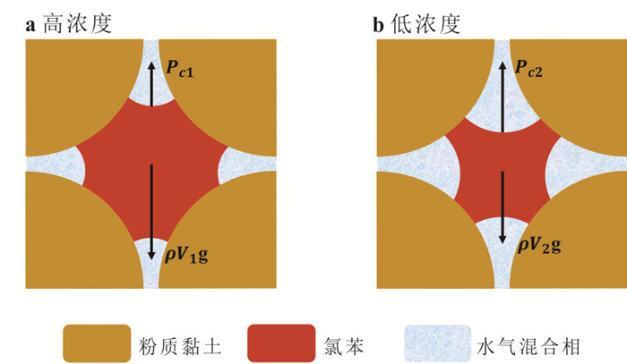
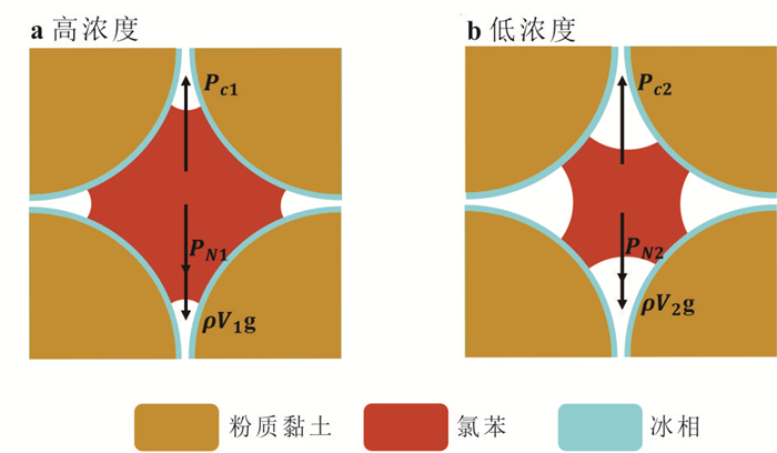
Elucidating the re-transport patterns and mechanisms of dense non-aqueous phase liquids (DNAPLs) in the vadose zone after spontaneous infiltration and stabilization under freeze-thaw cycles is crucial for the remediation of contaminated sites in seasonal freeze-thaw zones. Chlorobenzene (CB) was selected as a typical DNAPL, and silty clay from the Sejila Pass in Xizang was used as the porous medium. A stratified nuclear magnetic resonance (NMR) technology was used to quantitatively test the CB content at the vertical spatial location of the soil column after different infiltration times and freeze-thaw cycles. Studies have shown that as infiltration time increases, the concentration of CB decreases in the dimensionless infiltration depth range of 0-0.375, and increases in the dimensionless infiltration depth range of 0.375-0.750. The freeze-induced pressure generated by freezing drives the downward transport of CB after it has stabilized, but the driving ability is limited. The smallest change rate of CB concentration after different freeze-thaw cycles is 3.51%, and the largest does not exceed 24%. During spontaneous infiltration and freeze-thaw cycles, the interaction of capillary force, gravity, and freeze-induced pressure controls the transport and distribution of CB at different vertical depths.
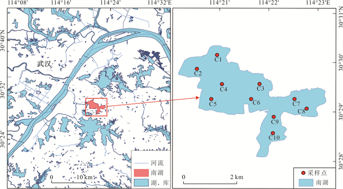
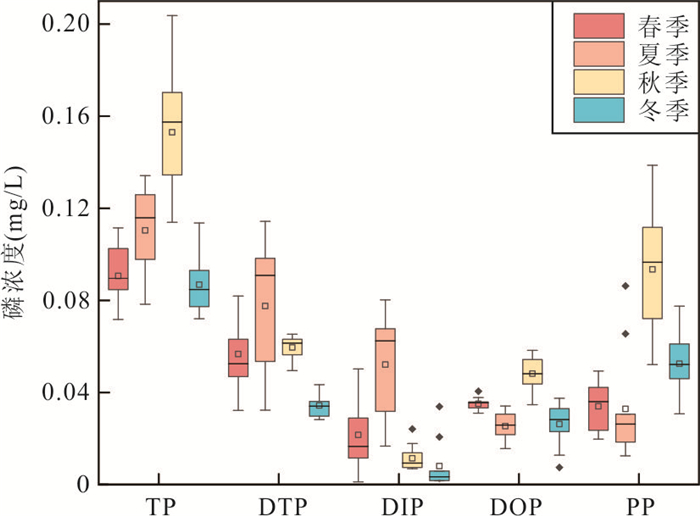
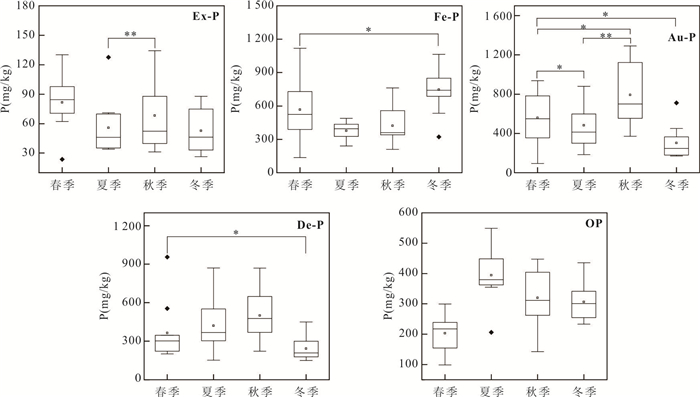
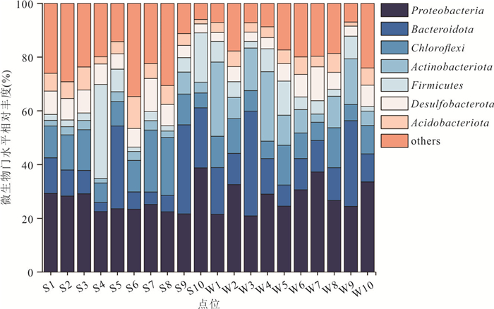
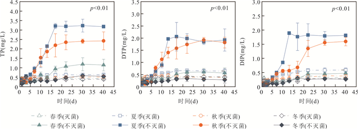
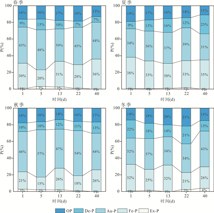
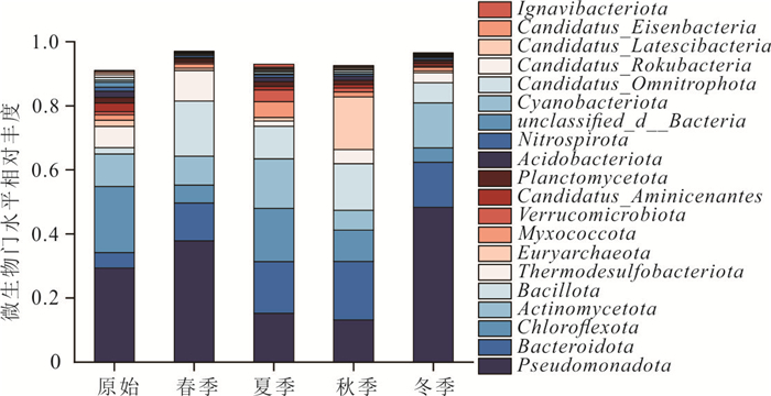
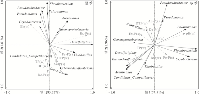
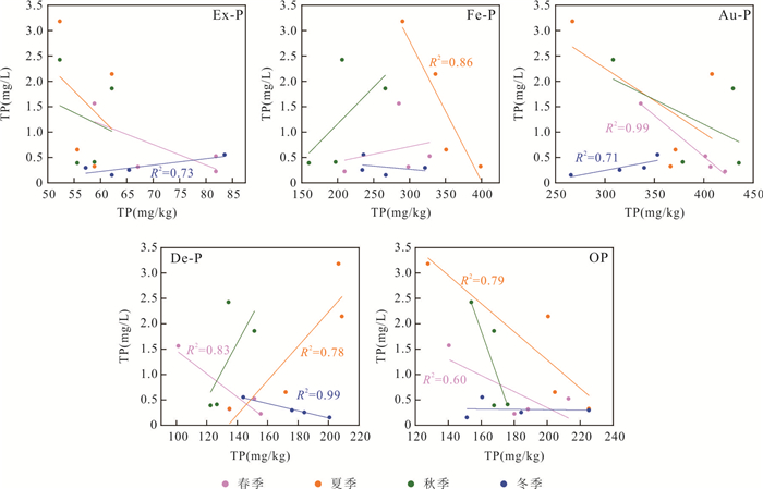
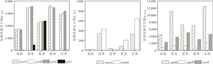
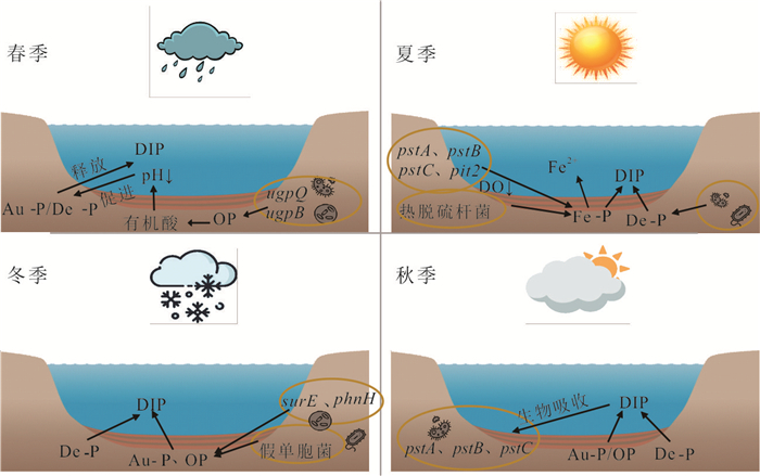
To elucidate the mechanisms underlying the seasonal fluctuations of endogenous phosphorus in shallow lake sediments, field sampling and laboratory simulations (controlling key parameters such as temperature and dissolved oxygen) of the overlying water environment across different seasons were conducted. This was integrated with sediment phosphorus form extraction and microbial functional gene quantification techniques to systematically reveal the seasonal patterns and driving mechanisms of endogenous phosphorus transformation. The results indicate that the seasonal fluctuations of internal phosphorus in shallow lakes are driven by overlying water conditions and involve shifts among the "mineralization-dissolution-uptake-storage" processes. In spring, high expression of the organic phosphorus mineralization gene (ugpQ) drove the dissolution of calcium-bound phosphorus(decreased by 70.56 mg/kg). Summer was characterized by a coupled microbial release-uptake process, dominated by reductive dissolution of iron-bound phosphorus (decreased by 108.55 mg/kg) alongside increased expression of the low-affinity phosphate transporter gene (pit2). The process of autumn shifted to a regime characterized by abiotic-dominated dissolution of calcium-bound phosphorus (decreased by 70.55 mg/kg), while microorganisms concurrently enhanced phosphorus uptake via the high-affinity phosphate transport system (indicated by high pst gene expression). In winter, cold-tolerant bacterial communities activated the carbon-phosphorus lyase gene (phn) to utilize refractory phosphorus. This study deepens the understanding of the coupled biochemical mechanisms governing endogenous phosphorus fluctuations.
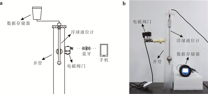
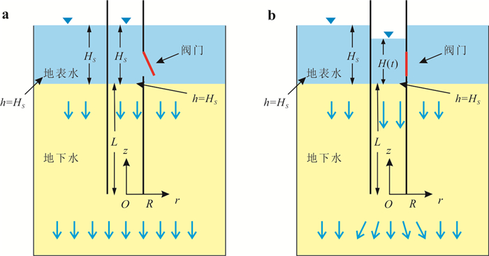
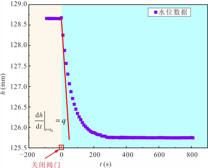
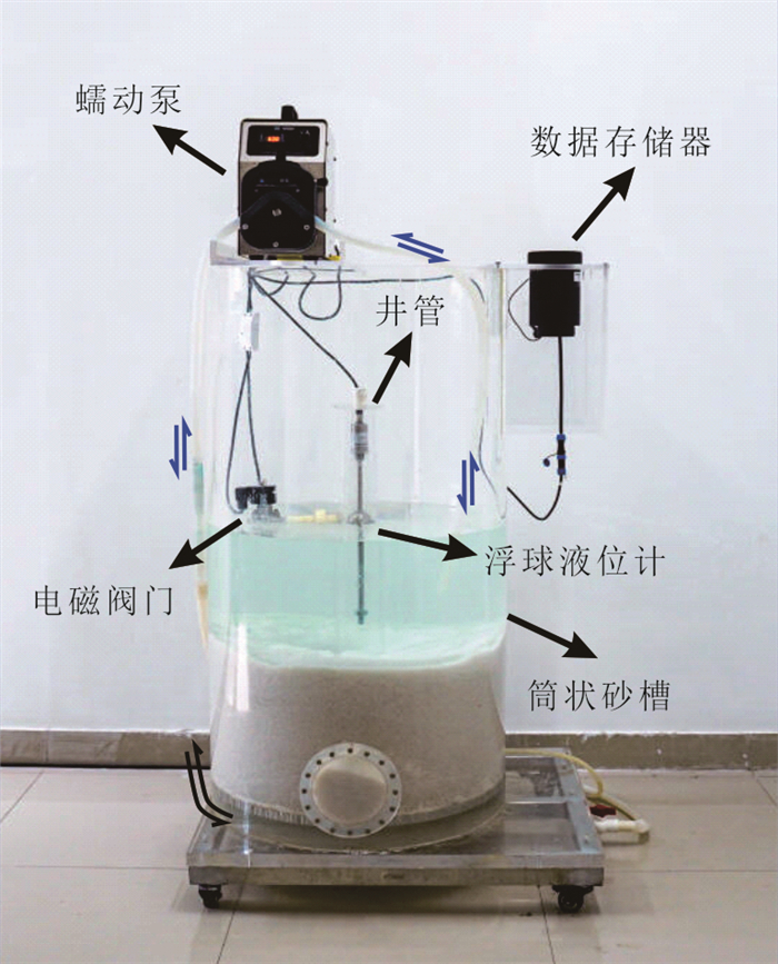
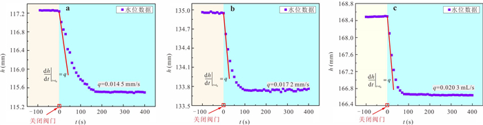
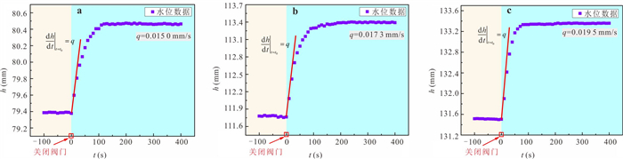
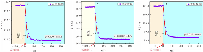
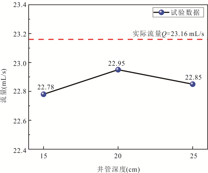
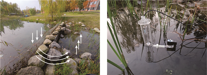
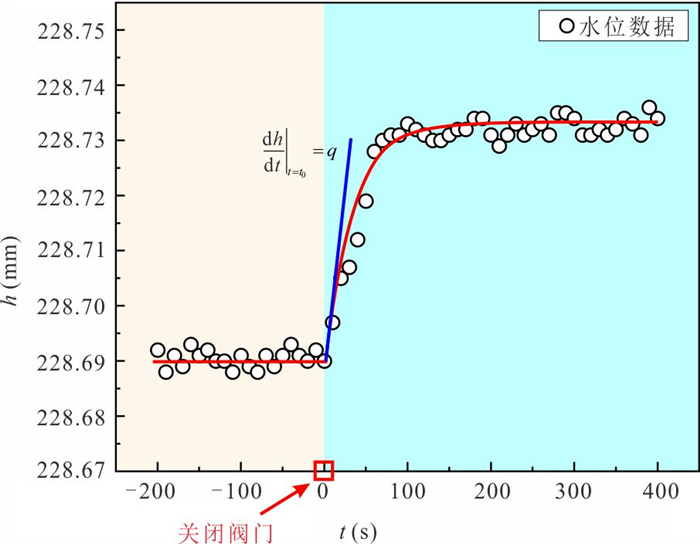
Quantitative assessment of water exchange flux in hyporheic zone is of great significance for understanding mass and energy transport and transformation in regional water cycles, as well as for contaminant remediation and management. However, due to factors such as heterogeneous streambed conditions and limitations in assessment methods, traditional approaches have struggled to achieve in situ, point-scale quantitative monitoring of hyporheic exchange fluxes.To address this, this study proposes a method using an automatic seepage meter to monitor and assess groundwater-surface water exchange fluxes, supported by both laboratory and field validation tests. The results demonstrate that the automatic seepage meter accurately monitors and assesses exchange fluxes under both groundwater discharge to surface water and surface water recharge to groundwater scenarios, with experimental relative errors below 3%.Variations in the insertion depth of the automatic seepage meter into the aquifer do not significantly affect the flux assessment results, indicating strong instrument stability. Field tests confirmed the device's capability to capture subtle groundwater dynamics during discharge events, quantifying groundwater exfiltration rate at 0.064 8 m/d. This research provides parametric and technical support for hyporheic flux assessment.
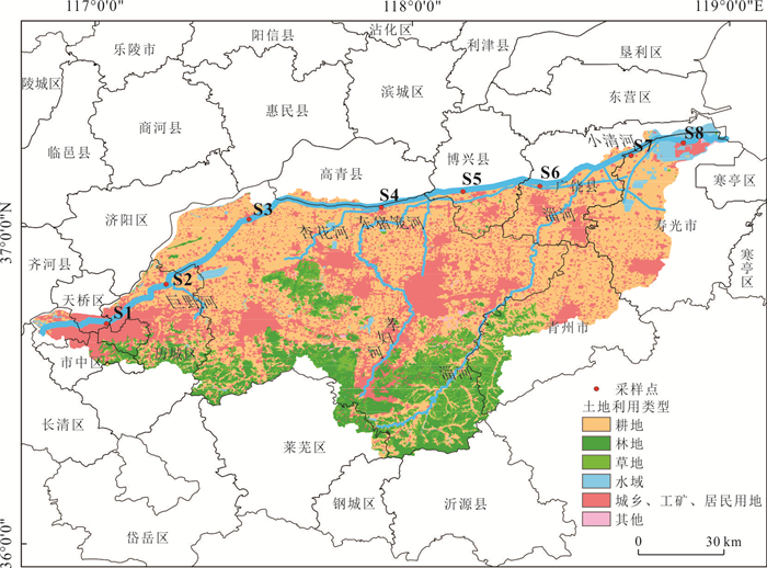
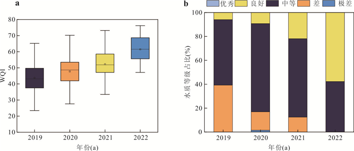
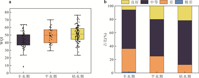
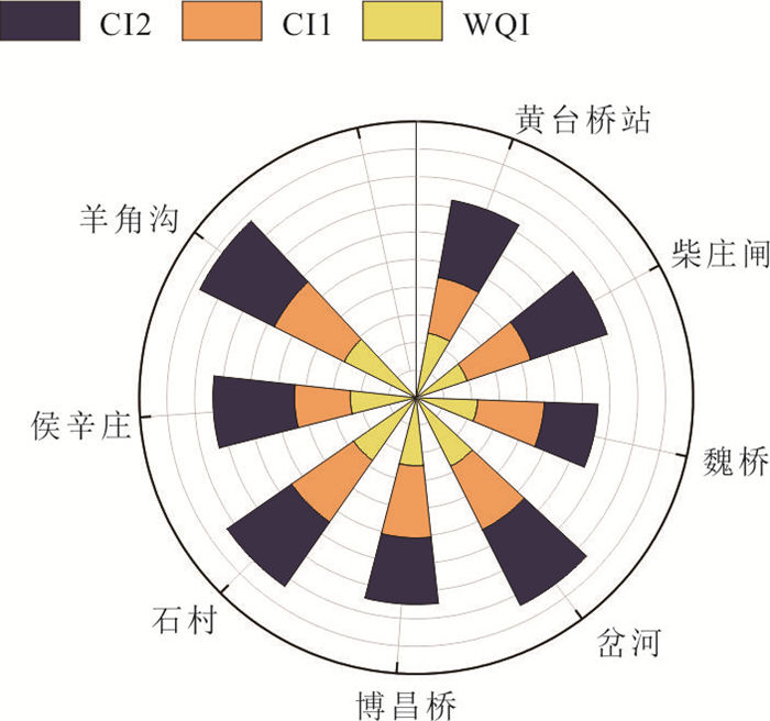
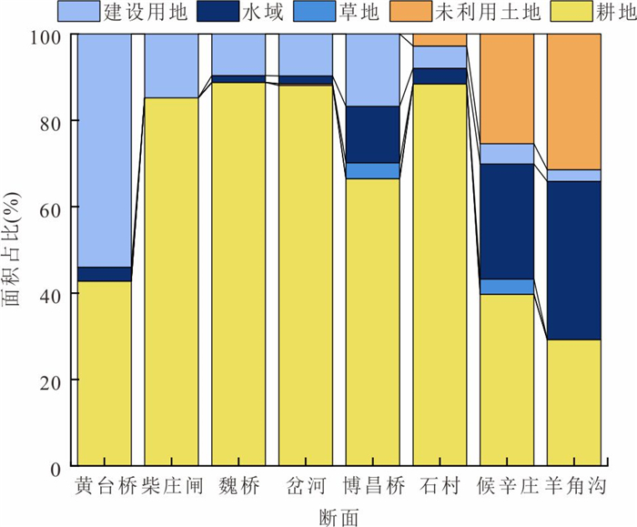
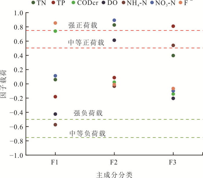
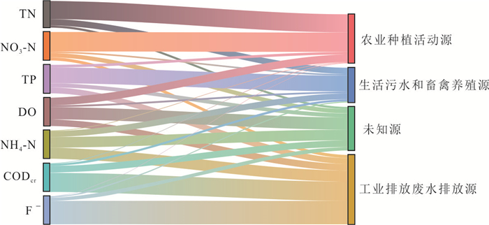
As a critical natural ecosystem supporting the survival of humans and other organisms, the water quality of rivers directly influences ecological security and sustainable development. To investigate the spatiotemporal variations in water quality of the Xiaoqing River mainstream, this study analyzed and evaluated these characteristics using the comprehensive water quality index (WQI) method based on monitoring data from 2019 to 2022. Additionally, an absolute principal component score-multiple linear regression (APCS-MLR) model was employed to identify pollution sources and quantify their contribution rates in the mainstream. The results indicate that the annual average WQI of the Xiaoqing River mainstream showed an increasing trend, with the water quality grade improving from "moderate" to "good" from 2019 to 2022. No significant seasonal variation in water quality grade was observed, though the WQI during the wet season was slightly higher than in other periods. Spatially, the WQI values along the Xiaoqing River mainstream generally exhibited a pattern of midstream < upstream < downstream, with the best water quality observed in the downstream section. Poorer water quality was primarily distributed in the midstream and upstream regions, particularly in areas with a high proportion of built-up and agricultural land along the main channel. Source apportionment results revealed that pollutant sources in the Xiaoqing River mainstream were diverse, with primary contributions from industrial wastewater discharge (25.81%), agricultural activities (24.92%), and domestic sewage coupled with livestock farming (17.60%). The predominant pollution sources were generally consistent across all monitoring sections, though dominant types varied spatially, which was closely associated with land use patterns and anthropogenic activities along the river. The findings of this study can provide an important scientific basis for pollution control decision-making in the Xiaoqing River basin.
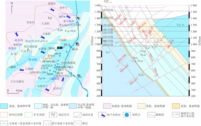
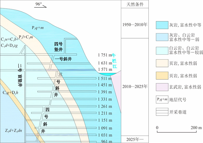
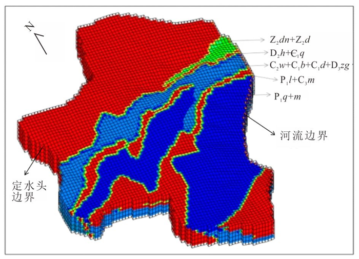
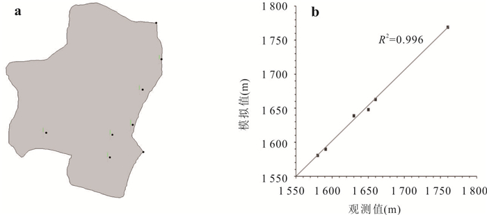
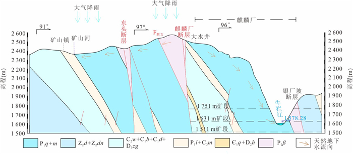
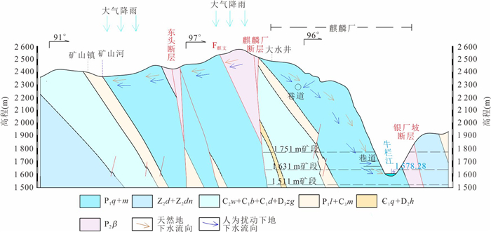
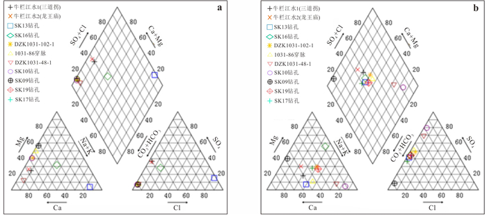
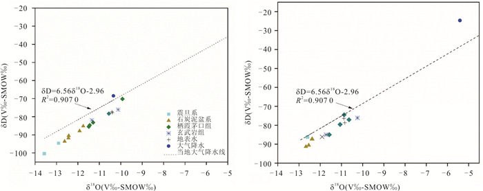
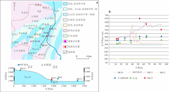
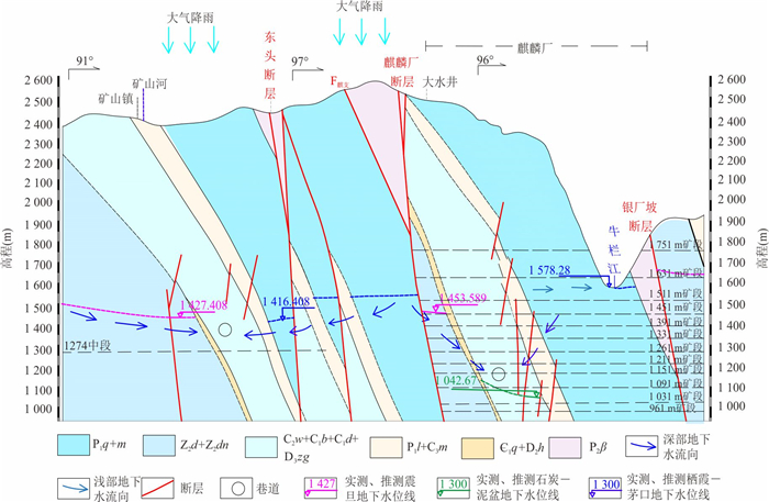
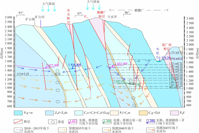
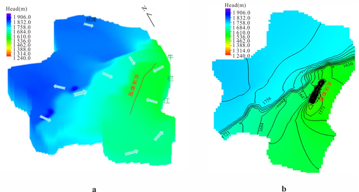
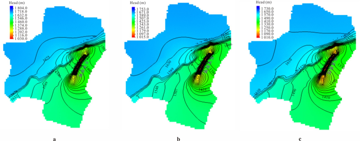
The Huize lead-zinc mine is located in the karst plateau of northeastern Yunnan. Long term mining has formed a complex underground mining tunnel system below the local minimum erosion benchmark level of the Niulanjiang River. The interaction between karst surface water and groundwater in the mining area is extremely complex under the influence of mining activities. In this article it uses hydrochemical and isotopic techniques, tracer experiments, numerical simulations, and other methods to deeply explore the interaction process between surface water and groundwater in mining areas. The following conclusions are drawn. Under natural conditions, groundwater is mainly supplied by atmospheric precipitation and discharged along the watershed to the Niulanjiang River. Under the disturbance of mining (1950—2010), shallow mining had limited impact on the regional groundwater flow system, only causing a local water level drop and changing the direction of local runoff. Under the conditions of intensified interference (after 2010), the first period (2010—2025) presents the characteristics of "weak natural circulation in the shallow part and strong artificial discharge in the deep part". The shallow aquifer is weakly connected to the Niulanjiang River, and the deep groundwater is discharged into the tunnel. The second period (after 2025) is characterized by a continuously expanding descending funnel, and it is predicted that the water level will decrease by about 64 m, 103 m, and 120 m in the 5th, 10th, and 20th years. In summary, the interaction between karst surface water and groundwater in mining areas is controlled by the hydrogeological structure of karst and mining activities. The research results provide theoretical basis for the development of scientific and effective waterproofing and drainage plans in the Huize lead-zinc mining area.
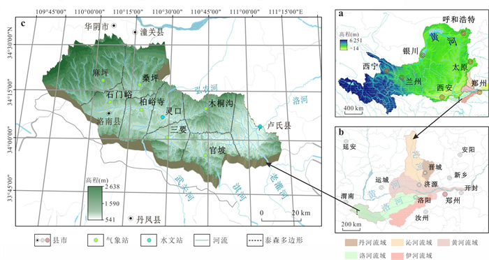
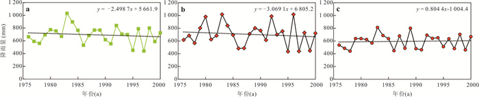
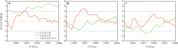
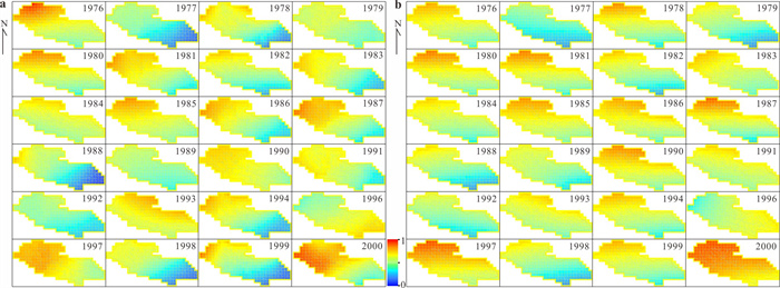
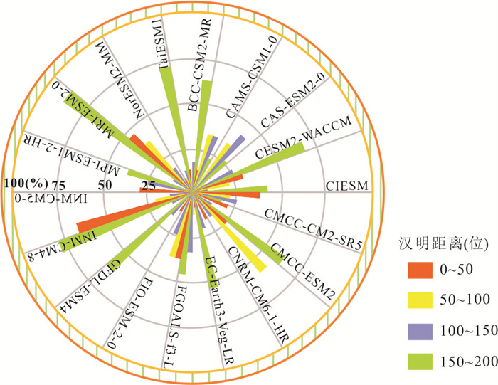
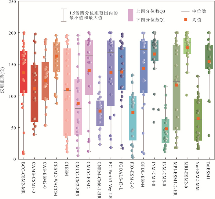
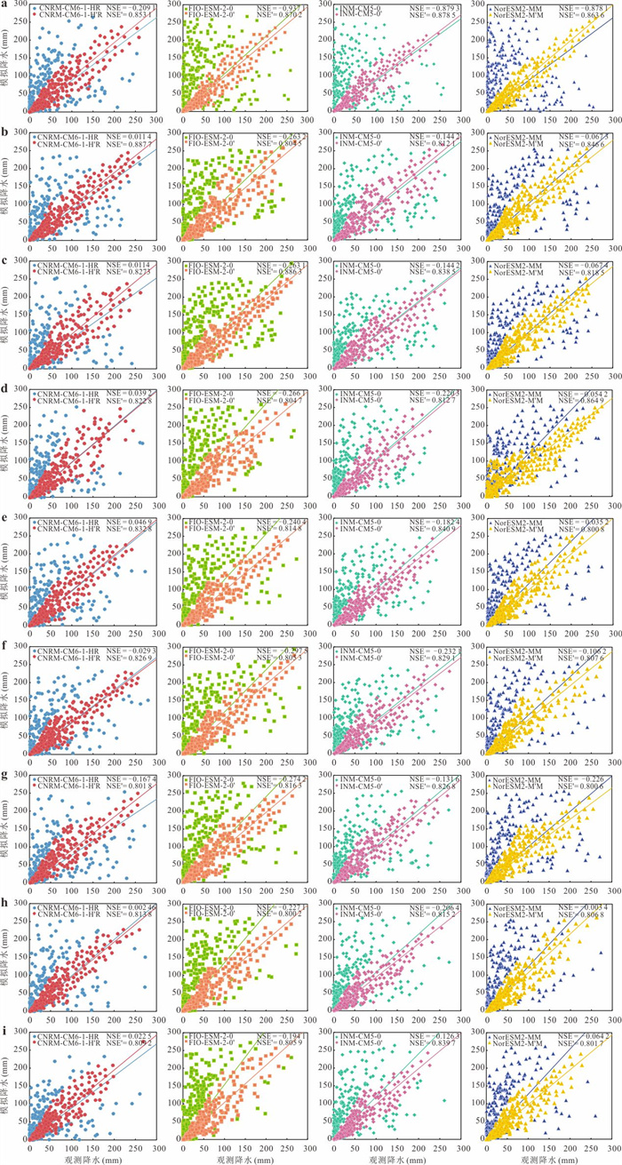
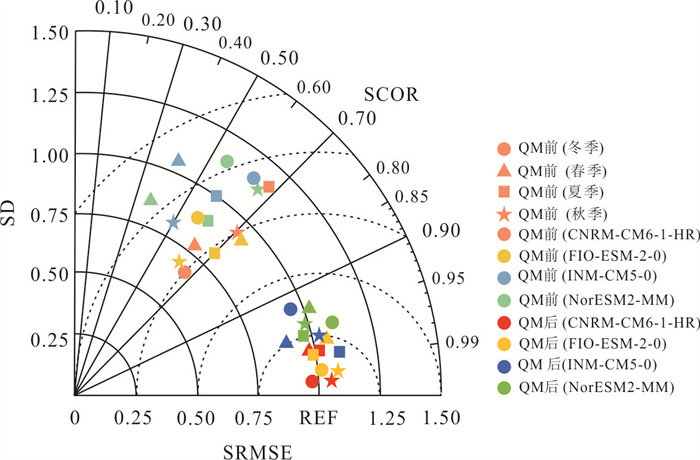
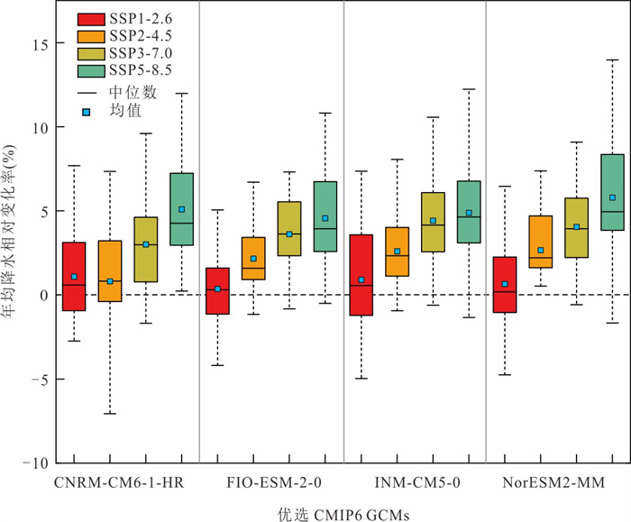
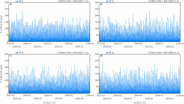
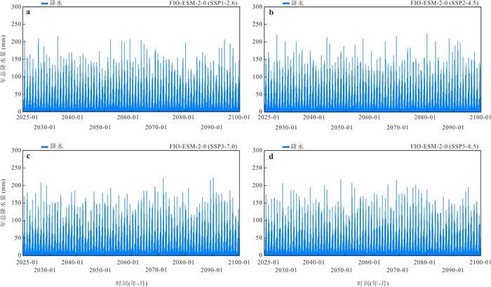
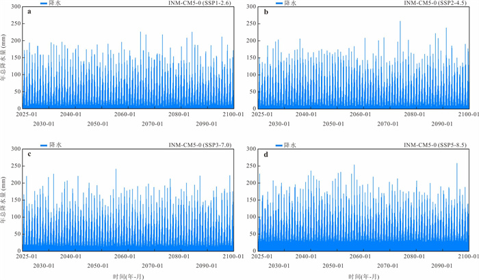
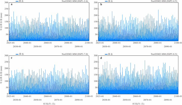
Climate change has led to an increased frequency of extreme hydrological events at the watershed scale. Evaluating the capability of CMIP6 global climate models (GCMs) to simulate precipitation and projecting future precipitation trends are essential for understanding future hydrological characteristics. Based on daily precipitation from 18 GCMs and 9 meteorological stations in the Lushi Basin during 1976—2000, an improved Hashing algorithm (ISHA) incorporating a spatiotemporal correlation mechanism was developed to select optimal GCMs, overcoming the limitation of fixed-grid partitioning in the traditional SHA. Non-parametric quantile mapping (QM) was then applied for bias correction. Based on the selected models, precipitation changes during 2025—2100 were projected under four SSP scenarios. The CNRM-CM6-1-HR, FIO-ESM-2-0, INM-CM5-0, and NorESM2-MM showed the best overall performance. The maximum monthly and long-term mean precipitation bias decreasing from 9.09%-16.04% and 10.41%-23.12% to 0.27%-2.34% and 0.48%-1.89%, respectively. The relative change in future annual precipitation increases with emission scenarios, ranging from -7.71% to 10.50% under low-emission conditions and expanding to -1.89% to 18.02% under high-emission scenarios. The basin may face an increasing risk of enhanced precipitation during the mid-to-late 21st century, thereby intensifying challenges in water resources management and flood control.
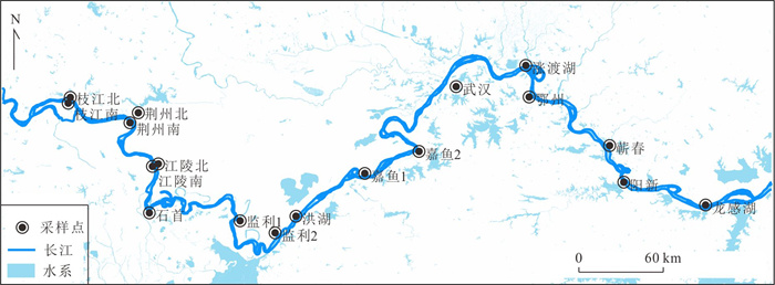
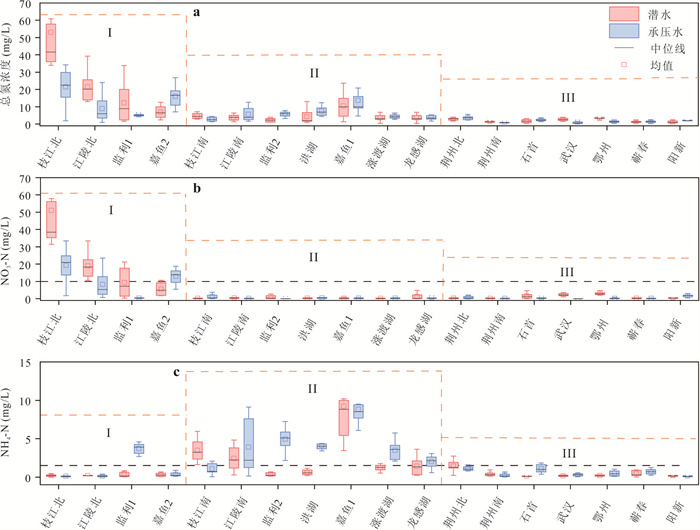
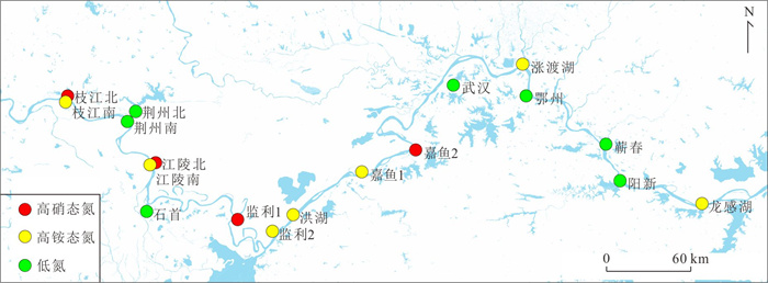
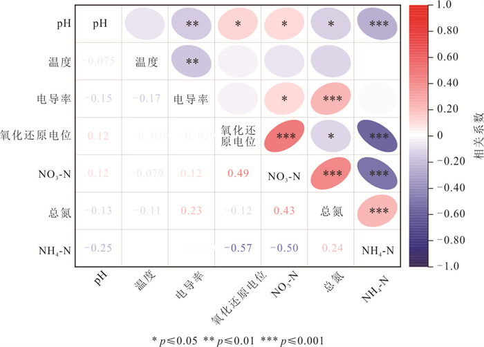
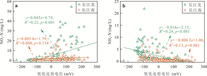
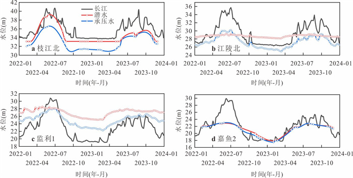
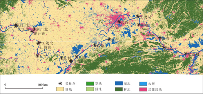
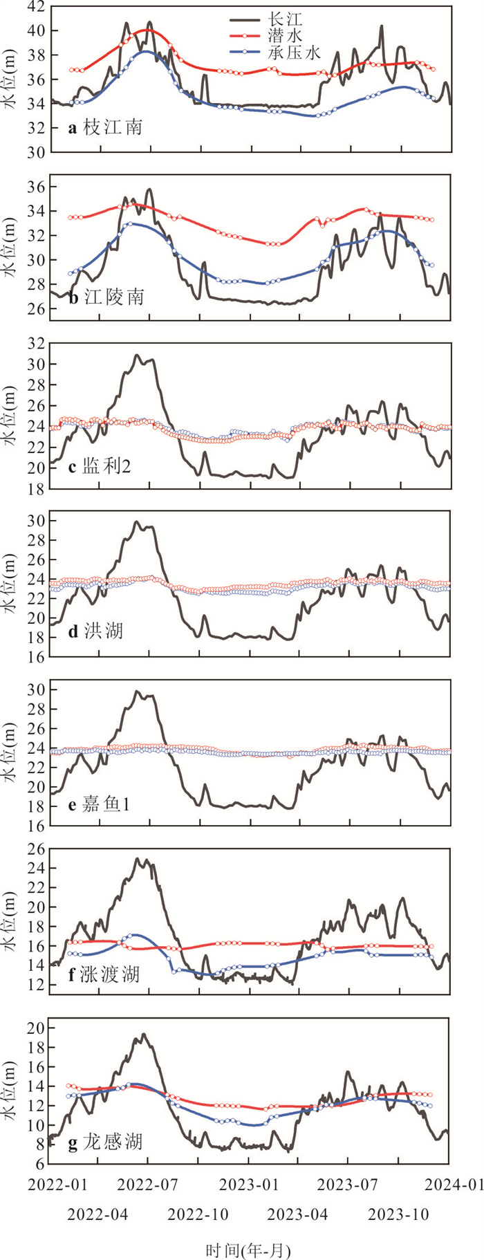
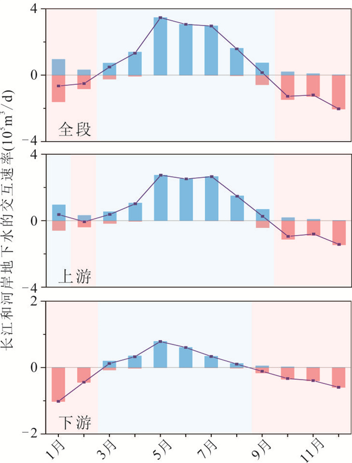
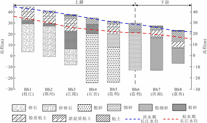
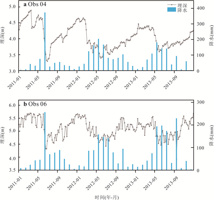
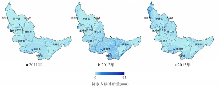
To explore the nitrogen distribution state and the influence of the surface water-groundwater recharge and discharge patterns on nitrogen enrichment in the groundwater along the Middle Reaches of Yangtze River, this study conducted hydrological monitoring for two years and analyzed 288 water samples at 18 monitoring points along the Middle Reaches of Yangtze River, systematically revealing the enrichment characteristics of nitrogen in the groundwater along the Middle Reaches of Yangtze River and the differences in recharge and discharge patterns of river - phreatic groundwater - confined groundwater in different enrichment areas. The results show that groundwater nitrogen concentrations exhibit significant variation. Three nitrogen distribution patterns were identified in the study area: high nitrate areas, high ammonia areas, and low nitrogen areas. The enrichment of nitrogen in groundwater on the northern side of the Yangtze River is mainly regulated by the redox potential, while the enrichment of nitrogen in groundwater on the southern side is controlled by multiple factors in combination. The high nitrate areas mostly occurs in confined groundwater, where nitrogen pollution is present in the upper phreatic groundwater and where phreatic groundwater, confined groundwater, and river water are connected, with river water as the primary source of replenishment. The high ammonia area mainly occurs in confined groundwater where the hydraulic connection among the phreatic groundwater, confined groundwater, and river water is weak or where groundwater discharges to the Yangtze River. It is not affected by nitrogen pollution in the phreatic groundwater and mainly originates from geological causes. The research results respectively reveal the enrichment characteristics of different forms of nitrogen in the phreatic groundwater and confined groundwater across the Middle Reaches of the Yangtze River and their connections with the connectivity and replenishment and discharge relationships among the phreatic groundwater, confined groundwater, and river water, providing essential scientific basis for the biogeochemical process of nitrogen and the source analysis of nitrogen in this area.
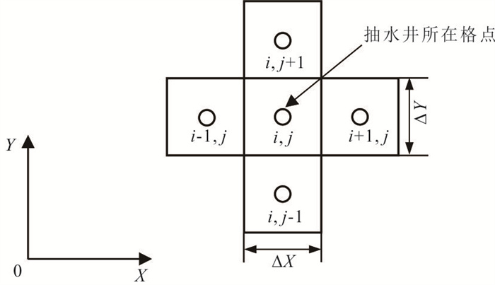
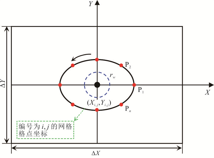
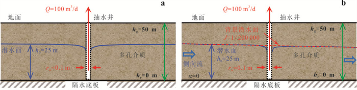
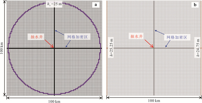
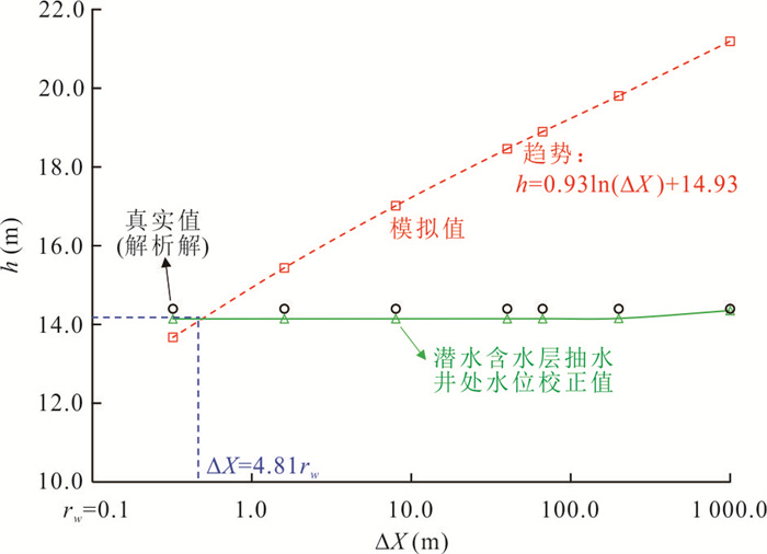
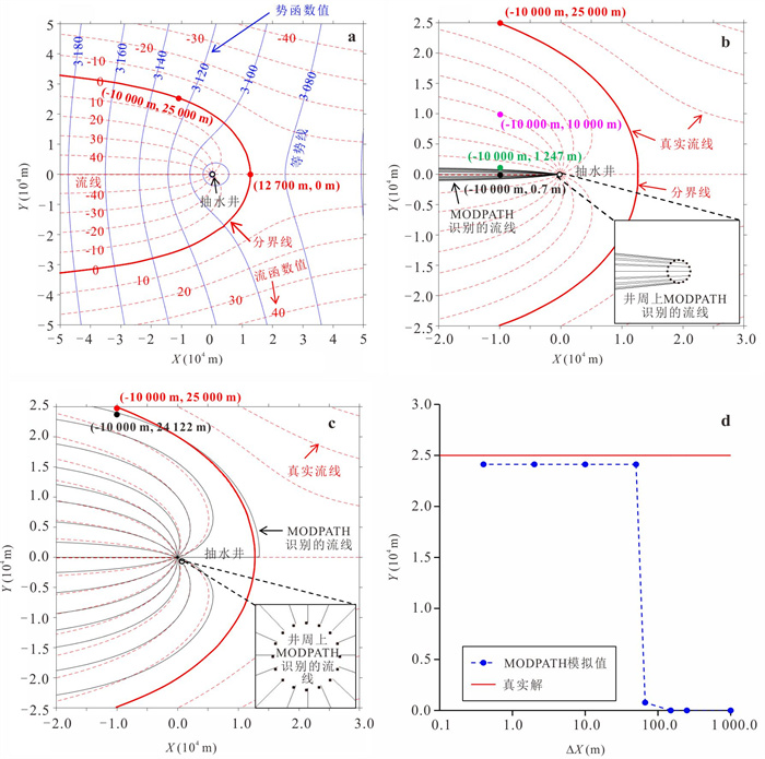
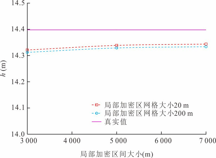
Block-centered finite difference method for simulating water levels and streamlines is the basis of numerous hydrogeological works. To address the simulation error of water levels at pumping wells in a phreatic aquifer and accurately identify streamlines, this study derives a water level correction fomula for pumping wells in the block-centered finite difference method based on complex potential theory. A coupled numerical model is developed to quantitatively analyze the impact of water level correction on the accuracy of streamlines. The results demonstrate that the correction formula significantly improves the simulation accuracy of water levels at pumping wells. Furthermore, it is clarified that when the discrete grid size is approximately 5 times the well radius, both water level and streamline simulation accuracy can be ensured without the need for correction. This study provides a theoretical basis and practical criterion for mitigating simulation errors caused by discretization in numerical modeling.
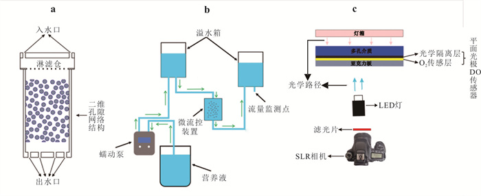
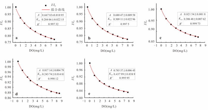
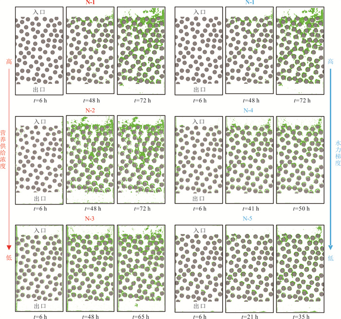
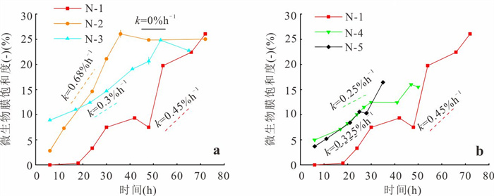
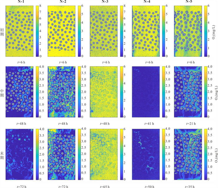
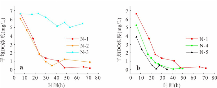
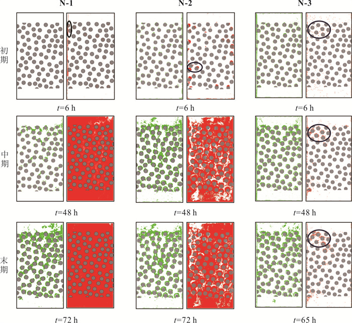
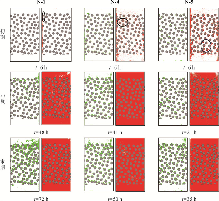
Anoxic microzone is an important redox reaction hotspot in porous media, however, the mechanism of its formation and evolution is not completely clear. Based on the self-built pore network-scale microfluidic experimental platform, combined with the in-situ visualization monitoring technology of biofilm and dissolved oxygen (DO), the effects of nutrient supply concentration and hydrodynamic conditions on the growth of microbial biofilm and the temporal and spatial distribution evolution of DO were systematically studied. The formation and evolution of anoxic microzones were directly observed and analyzed at the pore scale. Microbial membrane growth was not positively correlated with nutrient supply concentration. Only 12.5 mg/L glucose supply concentration combined with 0.125 hydraulic gradient can make the spatial distribution of DO always show the pattern of ' global oxic-local anoxic', so as to maintain the persistent anoxic microzone, and the other scenarios can only form temporary anoxic microzone. The synergistic effect of nutrient supply concentration and hydrodynamic conditions dominates the formation and evolution of persistent anoxic microzones by regulating the dynamic balance of DO supply and consumption.
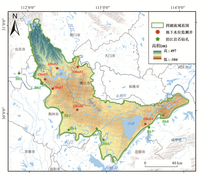
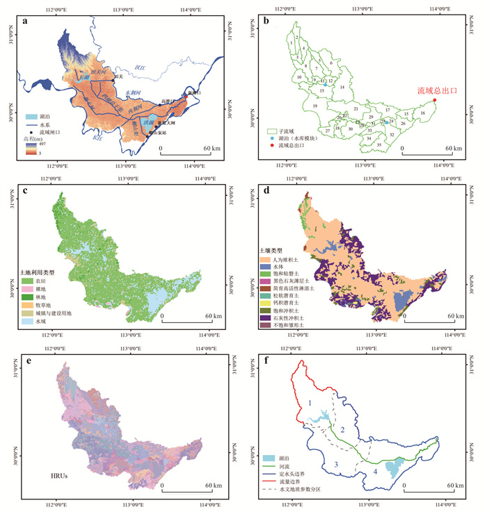
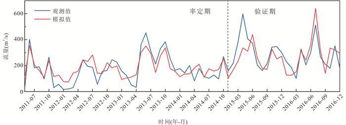
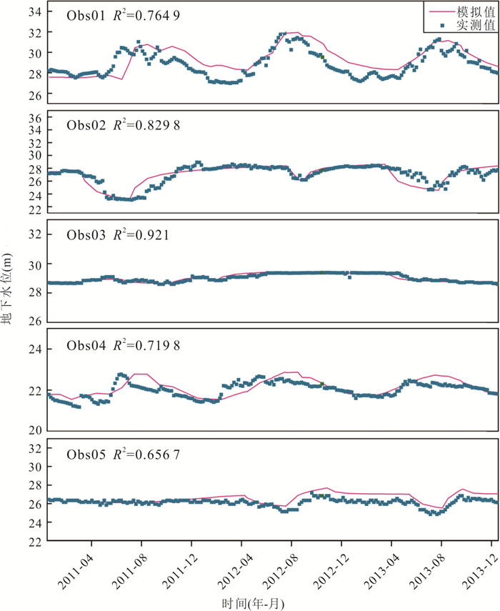
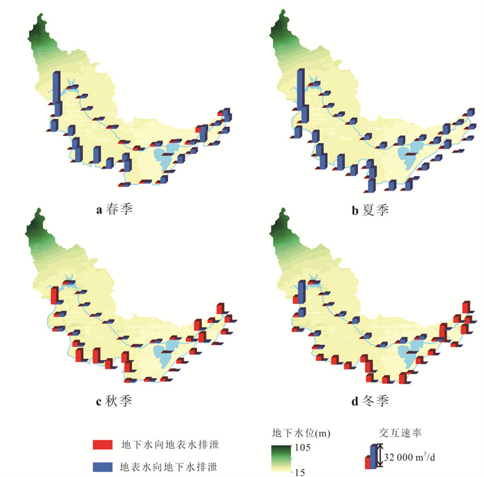
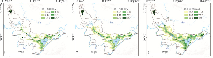
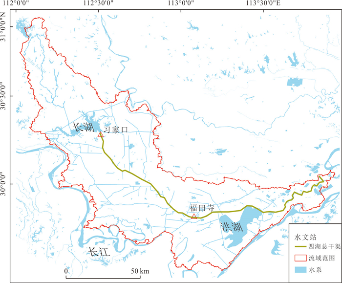
The Four-Lake basin in the Jianghan plain is a typical river-lake-wetland-farmland multi-element system in the Middle Reaches of the Yangtze River, facing prominent eco-environmental challenges. To accurately quantify the exchange rates between major water systems and groundwater in the basin and to analyze the main factors influencing the degree of soil gleyization, this study constructed a loosely coupled surface water-groundwater model for the Four-Lake basin using SWAT-MODFLOW. Based on the simulation results, the spatiotemporal variation in surface water-groundwater exchange rates and the distribution of cold waterlogged paddy field were systematically examined. The results show that the coupled model performs well in simulating both runoff and groundwater dynamics. The exchange between the Yangtze River and groundwater exhibits clear seasonal reversals: river water recharges groundwater in spring and summer, while groundwater discharges into the river in autumn and winter. Within the basin, the interaction intensity of Changhu Lake is higher than that of Hong Lake, and the main canal shows different exchange patterns between its upstream and downstream sections.The risk areas of soil gleyization (groundwater depth <3 m) are mainly distributed around Honghu Lake, along the Four-Lake main canal, and in the northwest of Jianli City, influenced jointly by rainfall infiltration, topography, and land-soil types. This study provides a quantitative basis for understanding water exchange processes and soil waterlogging risks in the Four-Lake basin, offering scientific support for regional water resources management and ecological conservation.
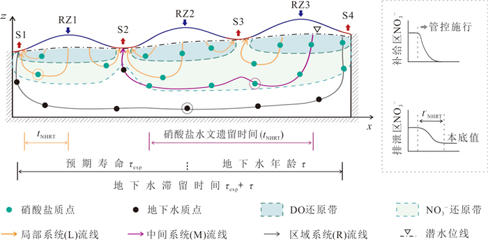
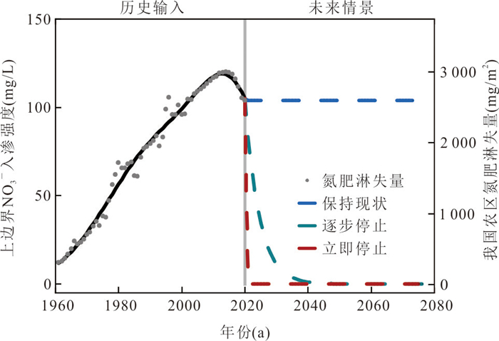
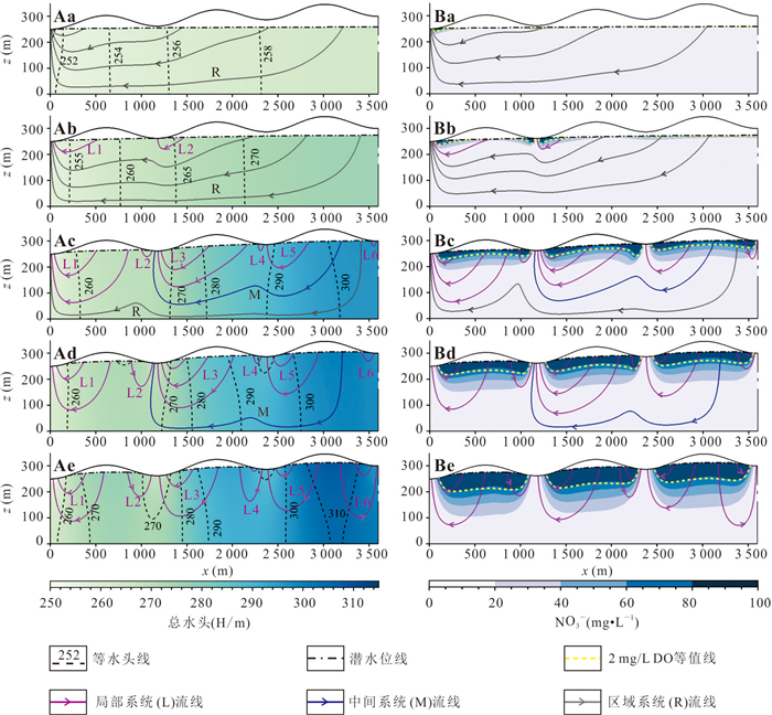
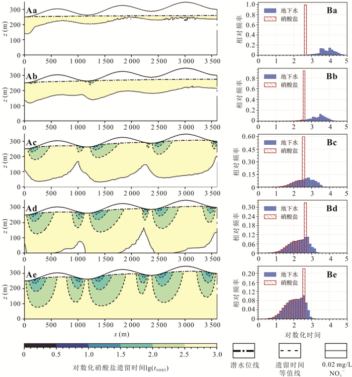
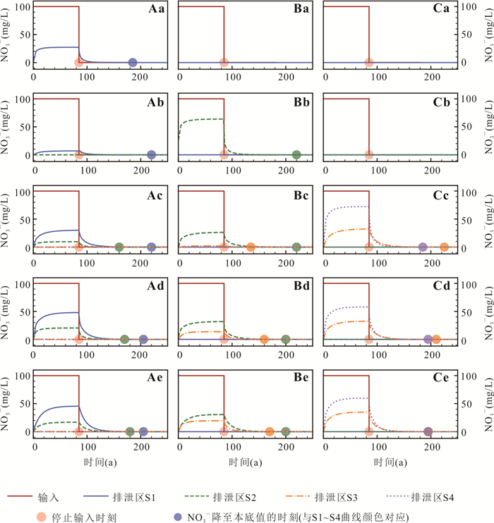
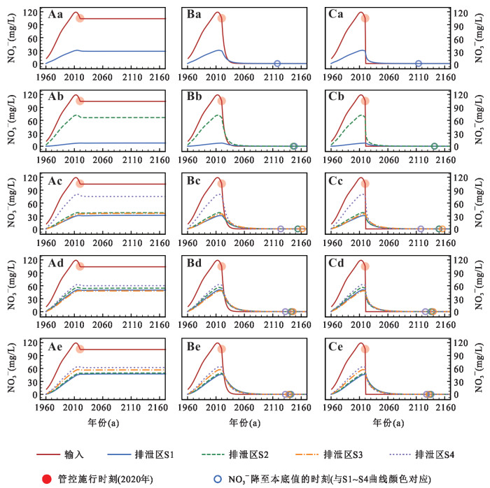
This study investigates the nitrate hydrologic residence time (NHRT) in a sandy, hierarchical groundwater flow system based on a 2D Tóth basin. Results show that with increasing groundwater recharge intensity, groundwater flow system evolves from a single regional system to nested systems, and finally to a single local flow system. The mean NHRT within the basin decreases across five distinct flow system patterns, but the proportion of longer-duration NHRT (250-500 a) remains dominant. Nitrate concentrations in discharge zones were primarily governed by adjacent local flow systems. A greater development depth of the local system prolongs NHRT in the discharge zone. Under nitrate input control scenarios, the baseline simulation (no input reduction) shows that concentrations in discharge zones stabilized within 2-8 years and then failed to decline. Compared to a gradual cessation, an immediate cessation of nitrate input accelerates recovery to background levels by only 4-6 years. The findings suggest that effective control of groundwater nitrate pollution requires either prioritizing input reduction in recharge areas of adjacent local flow systems or altering their development depth by regulating recharge intensity. Nevertheless, rapid cuts in nitrate loading do not substantially mitigate the inherent time lag of water quality response to remediation measures.
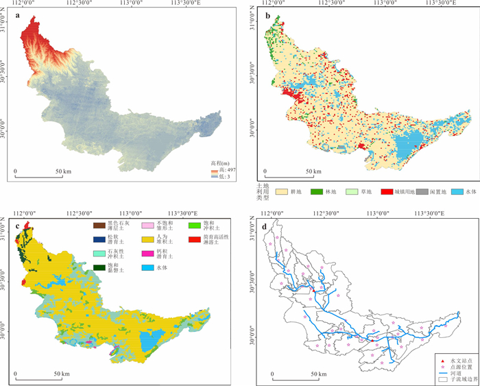
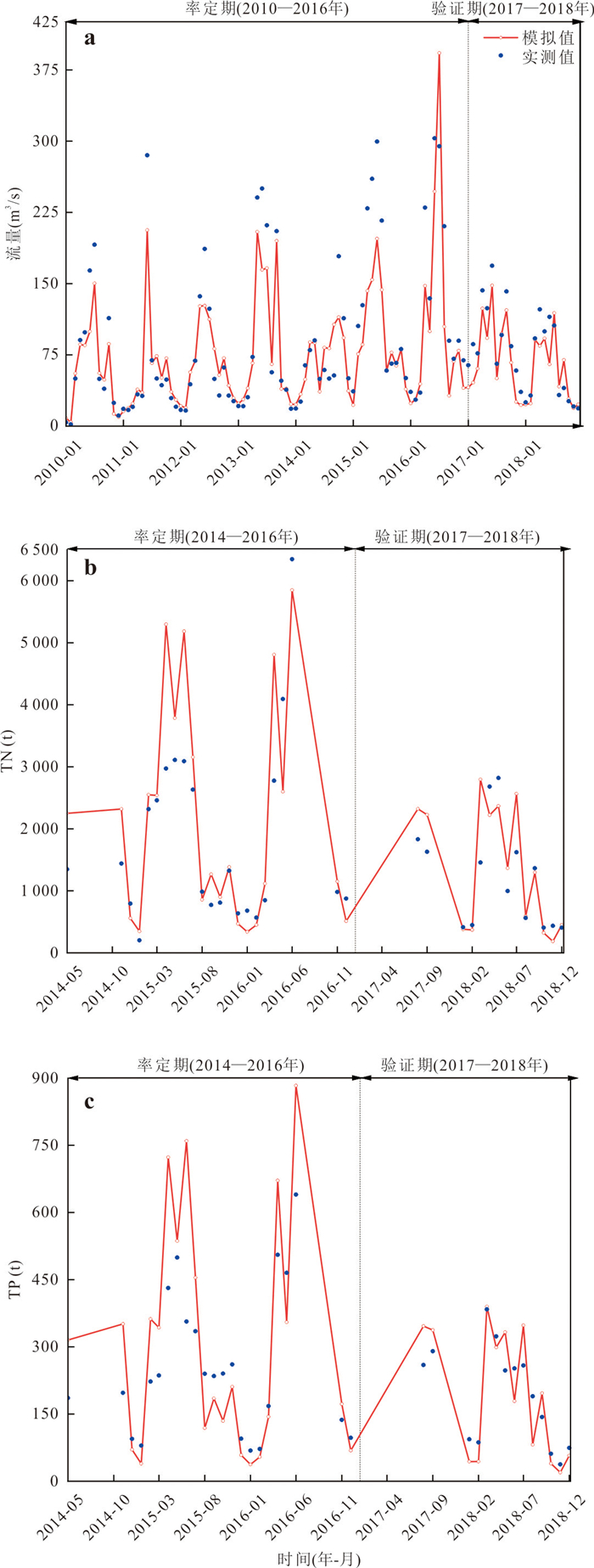
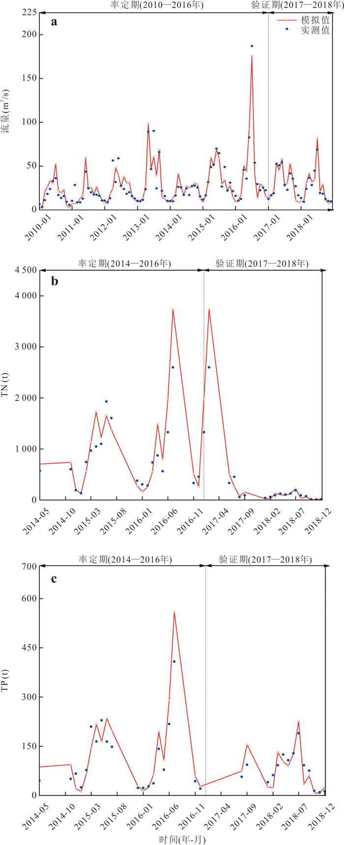
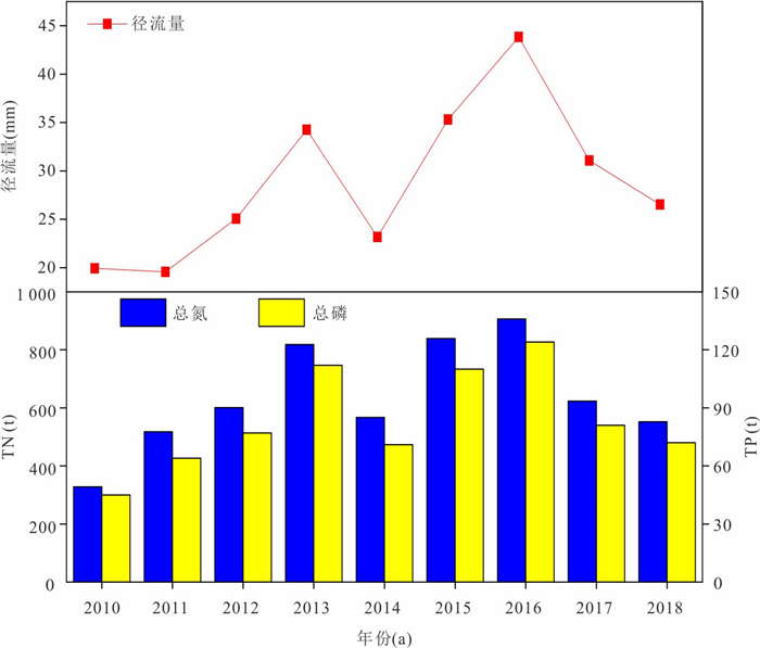
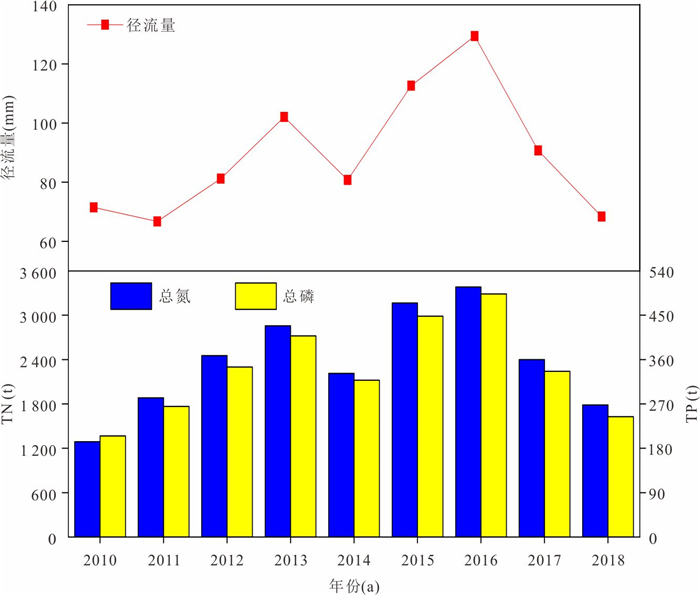
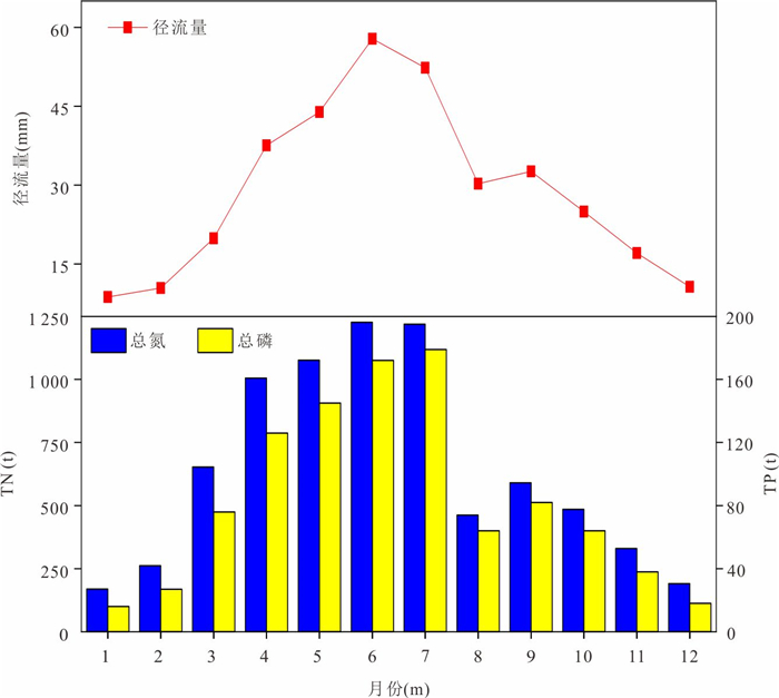
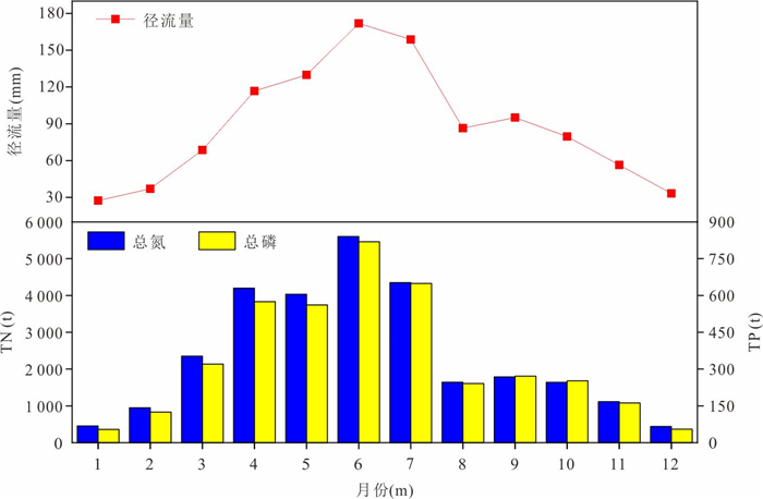
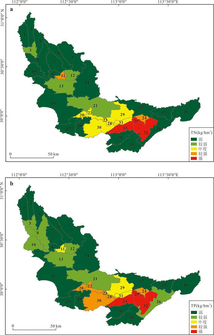
To accurately identify the sources, spatiotemporal distribution characteristics and key influencing factors of non-point source nitrogen and phosphorus pollution in the Sihu watershed, it provides a scientific basis for water pollution prevention and control in the basin, and addresses the prominent problem of lake eutrophication in the current watershed. Taking the Sihu watershed as the study area, a SWAT model was constructed to simulate the spatiotemporal distribution of non-point source nitrogen and phosphorus pollution in the basin. The results show that the model has a good fitting effect on runoff, total nitrogen (TN) and total phosphorus (TP) in the basin. Temporally, the TN and TP loads from 2010 to 2018 first increased and then decreased, reaching a peak in 2016, followed by a continuous decline from 2017 to 2018, with the characteristic of "high in flood season and low in non-flood season" within a year. Spatially, the sub-watersheds with high nitrogen and phosphorus loads are concentrated in the middle and lower reaches of the basin, namely sub-watersheds 11, 24, 25, 32, 33, etc. Cultivated land and water areas are the main pollution sources of nitrogen and phosphorus in the basin. The spatiotemporal distribution of nitrogen and phosphorus pollution loads in the Sihu watershed is comprehensively affected by runoff, land use and rainfall. Temporally, the flood season and spatially, lakes and agricultural areas are the key points for prevention and control. Pollution loads can be reduced by measures such as reducing chemical fertilizer use, controlling the scale of aquaculture, and protecting wetlands.
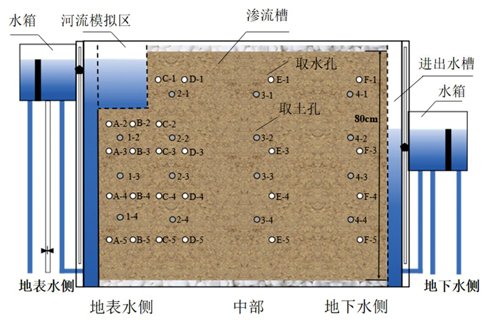
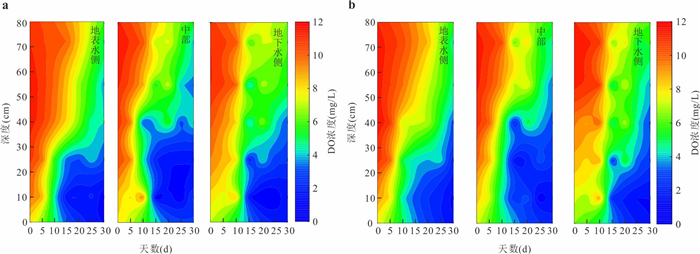
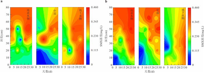
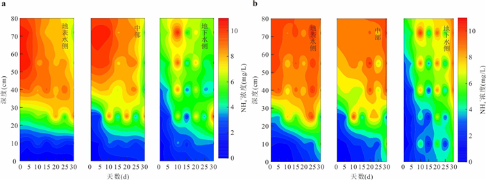
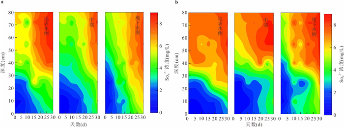
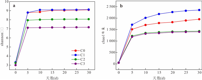
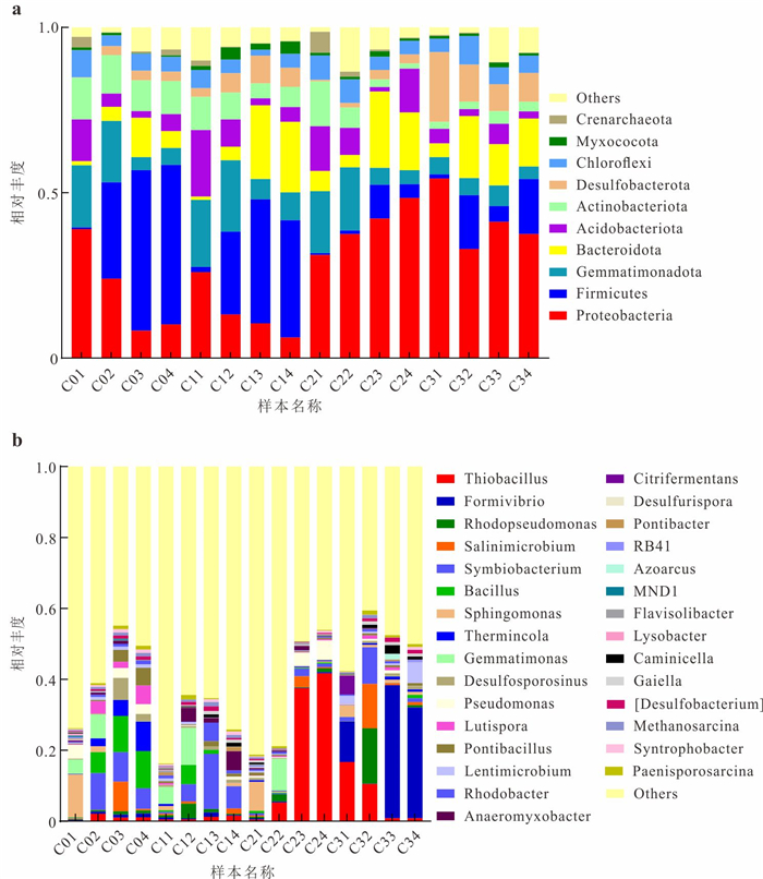
As a widely used antibiotic, sulfamethoxazole (SMX) is being increasingly detected in aquatic and soil environments, where its residual concentrations continue to rise. It is imperative to investigate the fate of SMX in the hyporheic zone, as it is critical for safeguarding river ecosystem health and ensuring water security. This study collected hyporheic sediments and conducted simulation experiments to investigate the migration and transformation processes of SMX within the hyporheic zone under various hydraulic gradients. The results demonstrate that dynamics of sedimentary environmental factors in the hyporheic zone, driven by surface water-groundwater interactions, were initiated by successive shifts in microbial diversity and community structure, which in turn modulated the migration and transformation processes of SMX. Hydrolysis, desulfonation, and biodegradation served as the primary pathways for SMX transformation in the hyporheic zone, with the dominant attenuation mechanism transitioning over the course of water interactions. Proteobacteria and Firmicutes were the primary microbial groups in the hyporheic zone and the key drivers of SMX biodegradation. The removal efficiency of SMX varied with hydraulic gradients in the hyporheic zone, with a more significant removal observed under the lower hydraulic gradient condition.
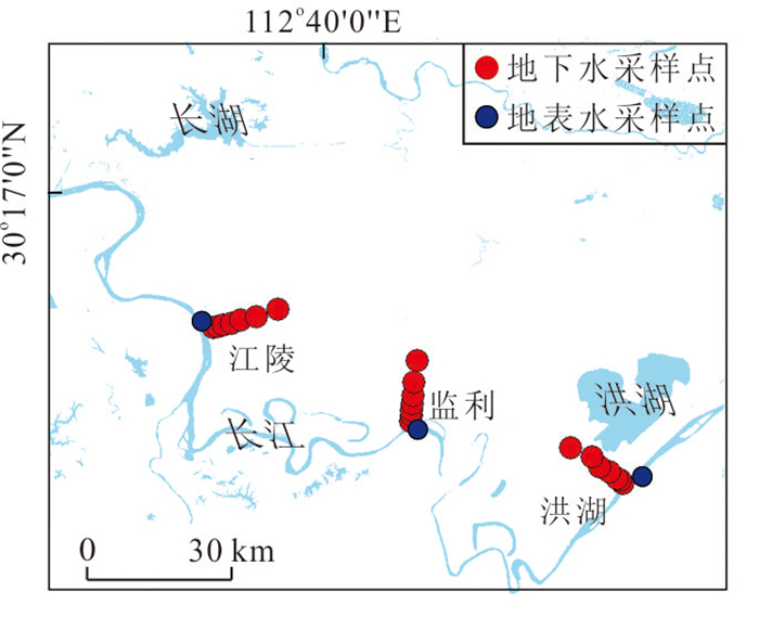
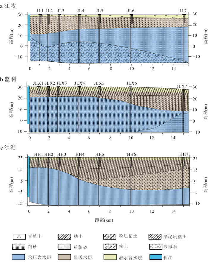
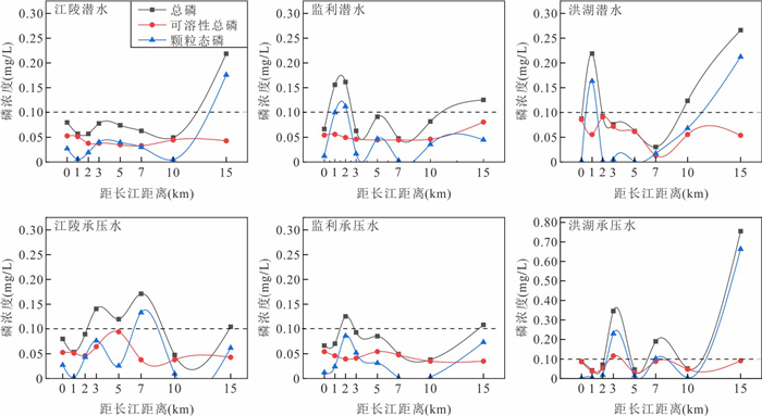
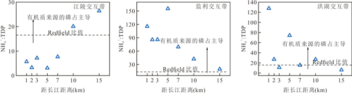
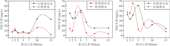
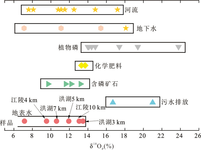
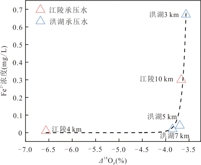
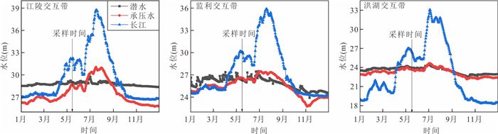
To investigate the enrichment characteristics and underlying mechanisms of phosphorus (P) in groundwater within the river lateral interaction zone, this study conducted hydrochemical and phosphate oxygen isotope (δ18Op) analyses on three lateral interaction zones (Jiangling, Jianli, and Honghu) within the Four Lake basin. The results reveal the widespread presence of significant P enrichment zones in the groundwater of the interaction zones, with the locations of enrichment differing between the unconfined and confined aquifers. Hydrochemical analysis indicats that P enrichment in the Jianli section is primarily driven by organic matter mineralization. In contrast, in the Jiangling section, it is more closely related to mineral dissolution/release. The Honghu section appears to be regulated by a combination of both processes. The δ18Op data confirmed the crucial role of microbially mediated reductive dissolution of P from iron oxides in the enrichment of P in the confined aquifer. The spatial variation and dominant mechanisms of P enrichment in the interaction zones are regulated by hydrological processes. More intense hydrological dynamics enhance the role of organic matter in P enrichment, shifting the enrichment zone closer to the Yangtze River.
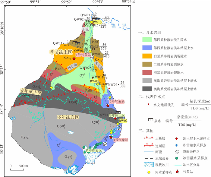
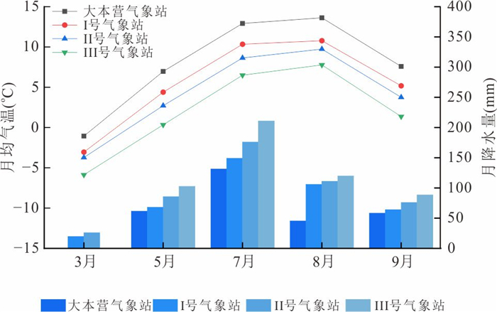
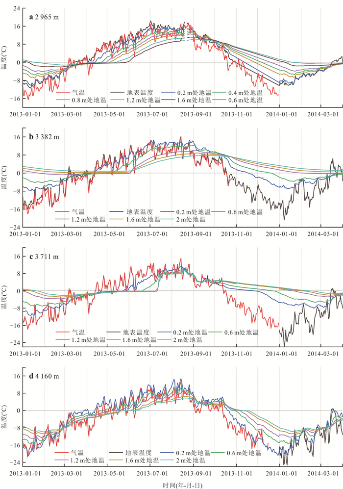
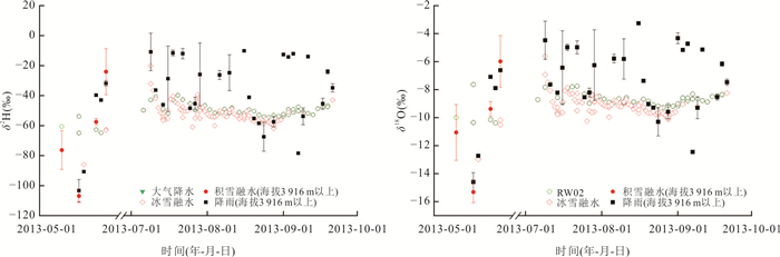
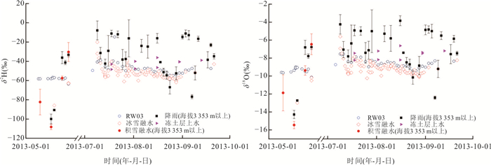
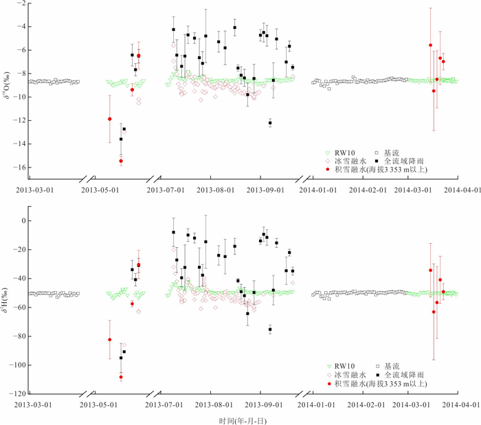
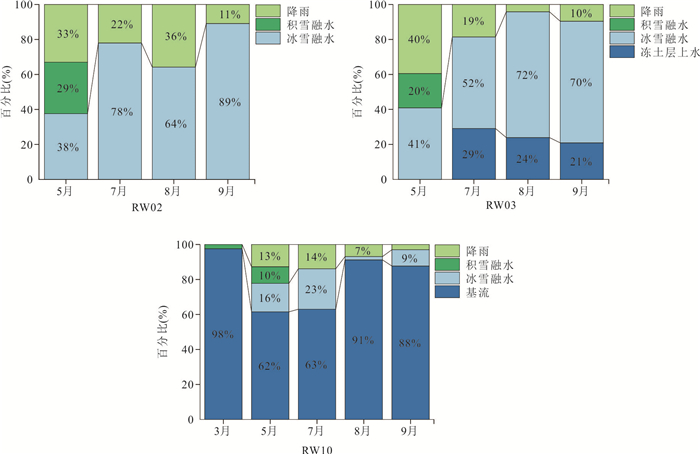
The alpine region serves as an important water source for downstream areas, and its runoff processes are highly complex due to the influence of underlying surface conditions such as permafrost. Compared to large-scale watersheds, small watersheds are more suitable for elucidating the dominant role of the underlying surface in hydrological processes, However, related research remains limited due to data scarcity caused by harsh environmental conditions in high-altitude areas. To further elucidate the spatiotemporal variations in river runoff sources at the small-watershed scale, this study takes the Hulu watershed in the upper reaches of the Heihe River as an example. By integrating water-stable isotopes with hydrometeorological observations, the MixSIAR model was applied to quantitatively determine the runoff components in the periglacial bedrock area, permafrost area, and seasonally frozen-ground area. The results show that in March, runoff in the seasonally frozen-ground area was dominated by baseflow (98%), while other regions experienced flow cessation. In May, glacier-snow meltwater and snowmelt were the main sources in both the periglacial bedrock area and permafrost area, although baseflow remained dominant in the seasonally frozen-ground (62%). From July to September, glacier-snow meltwater became the primary source in the periglacial bedrock and permafrost areas, whereas baseflow continued to dominate in the seasonally frozen-ground area (more than 63%). The findings indicate that meteorological factors are the primary drivers of runoff variation, while underlying surface conditions—such as permafrost distribution and aquifer characteristics—play a critical regulatory role in water-source composition. This study enhances the understanding of hydrological processes in small alpine regions and provides theoretical support for water resource management in cold environments.
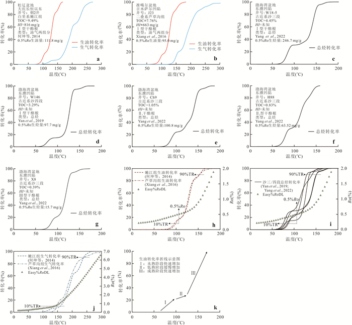
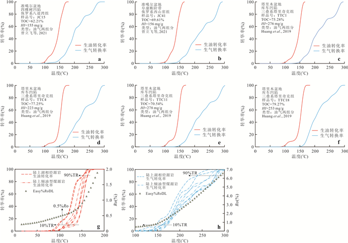
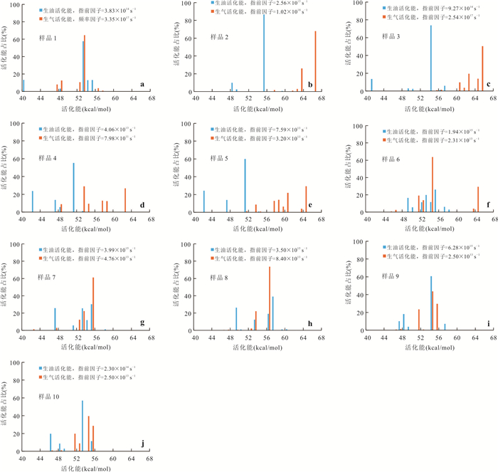
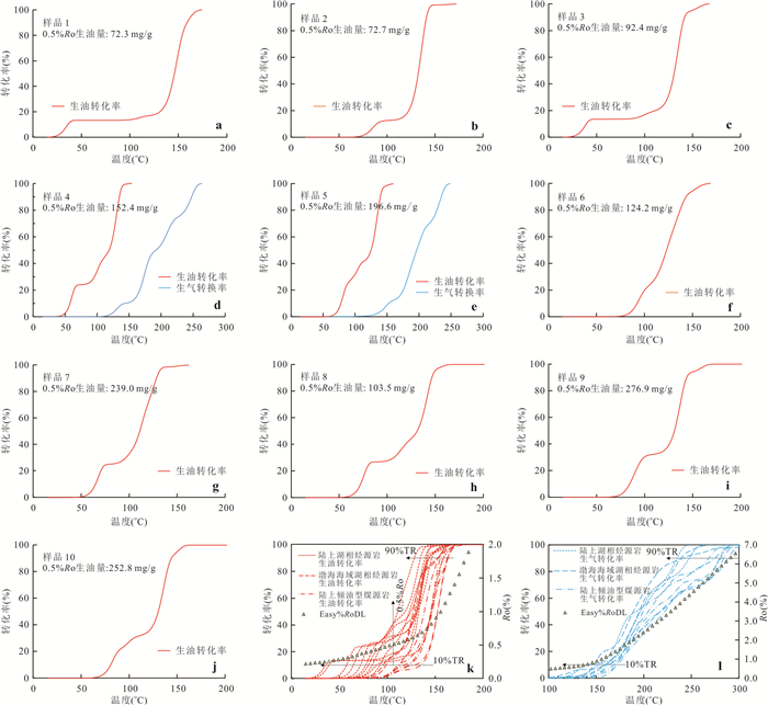
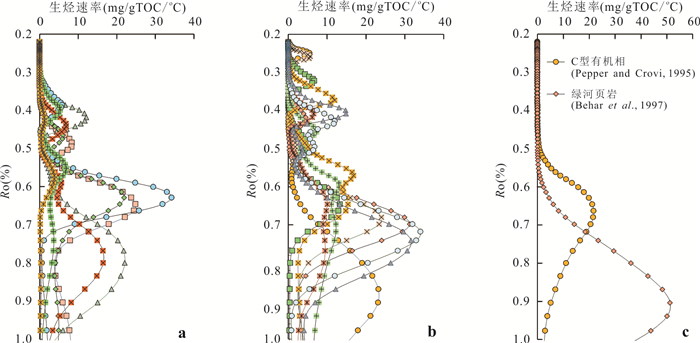
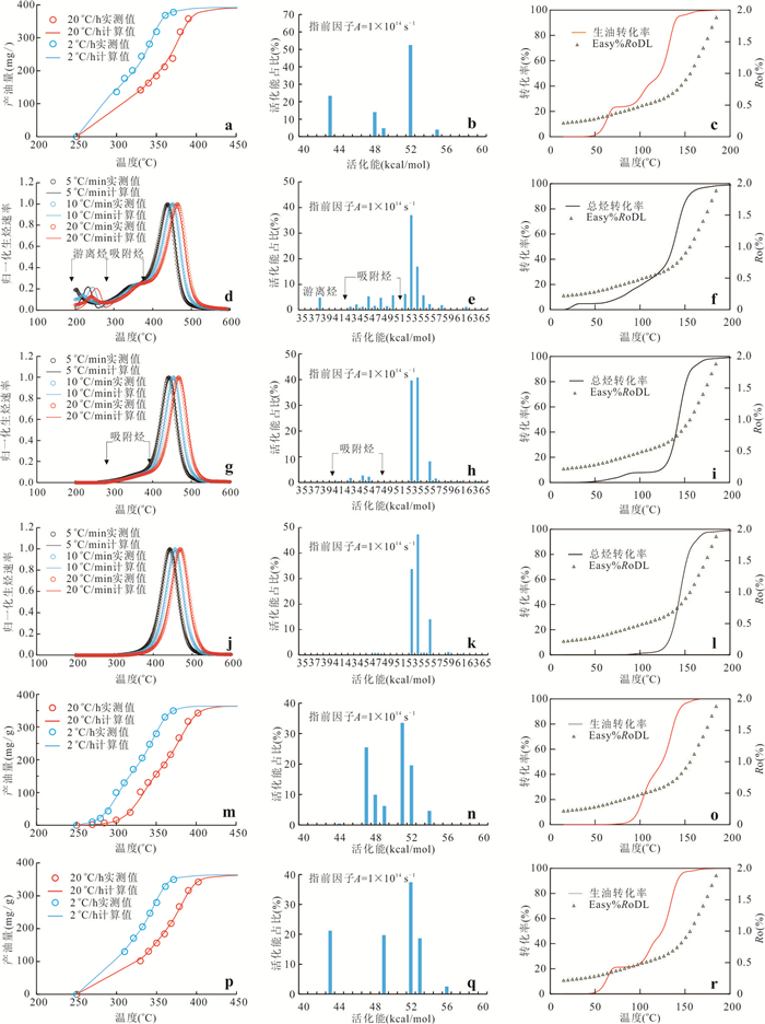
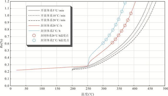
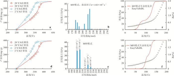
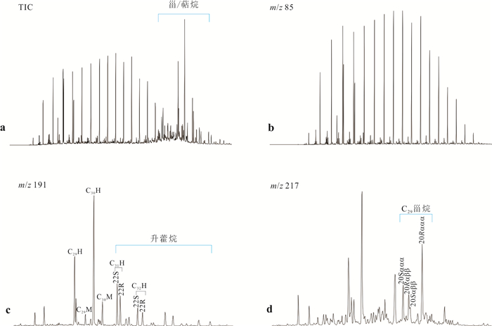
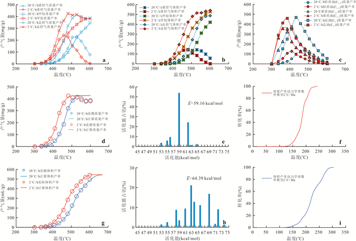
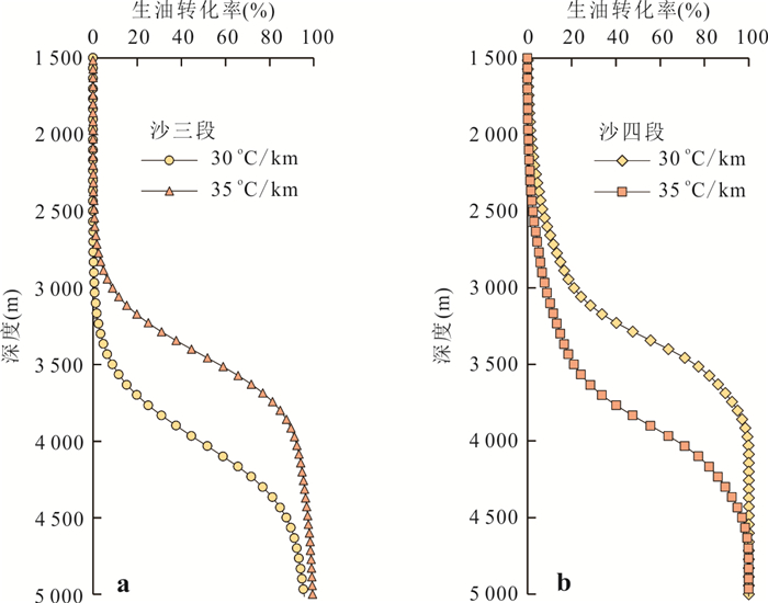
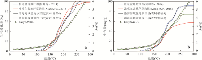
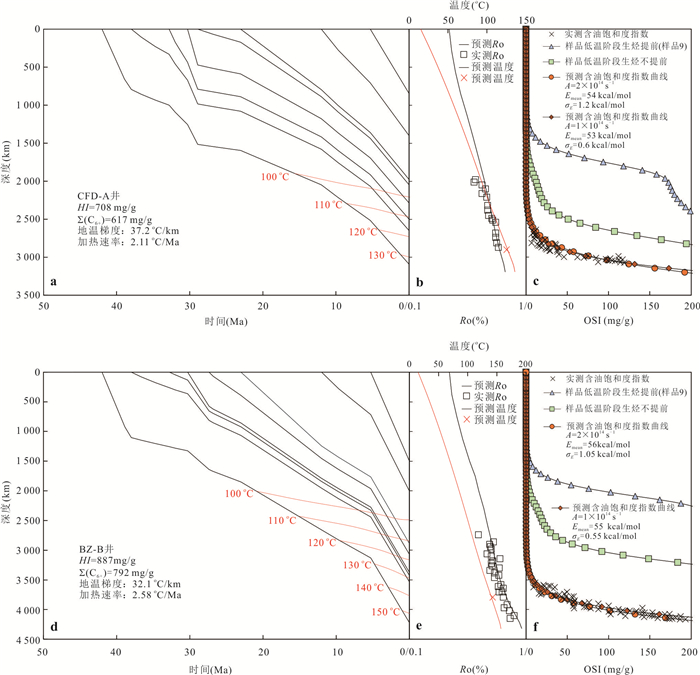
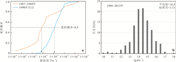
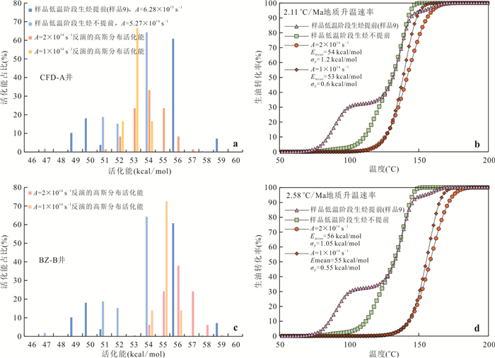
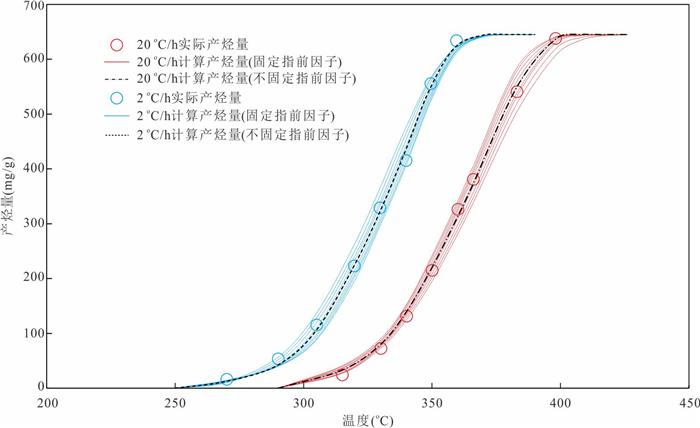
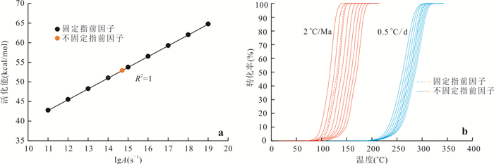
In response to the urgent needs of national oil and gas resource evaluation, detailed exploration of mature super-basins and shale oil research, the gold-tube pyrolysis hydrocarbon generation kinetics technology has been widely applied in the study of lacustrine source rocks in recent years. To clarify the technical risks of extrapolating the gold-tube hydrocarbon generation kinetics parameters of lacustrine source rocks to geological conditions for guiding conventional and unconventional oil and gas resource evaluation and exploration, the hydrocarbon generation kinetics parameters of 23 lacustrine and oil-prone coal-measure rocks from four super-basins, namely the Bohai Bay, Songliao, Tarim and Junggar, were extrapolated to geological conditions and parallel gold-tube and Rock-Eval pyrolysis experiments were conducted on lacustrine source rocks. The issues of calibration, application, validation and false compensation effect of the gold-tube hydrocarbon generation kinetics parameters were discussed. (1) The oil generation kinetics parameters often show an early oil generation phenomenon at low temperatures in geological applications, which is related to the residual adsorbed hydrocarbons, the lack of temperature points in the low-temperature stage of pyrolysis, and the defects in the calibration of the kinetics parameters using the single pre-exponential factor model. (2) When calibrating the gas generation kinetics parameters using the mass or volume yield of hydrocarbons and gases, it is necessary to compare the mass or volume yield characteristics of different components (C1, C2-5, C1-5, C6+) to clarify the cracking degree of crude oil and heavy hydrocarbon gases. (3) The oil generation transformation rate curve of lacustrine source rocks in the oil generation window is steep, and the difference in geothermal fields significantly affects the calculation results of oil generation. The study of geothermal fields should be strengthened in petroleum resource evaluation. The gas generation kinetics parameters should be applied in geological terms in combination with the gas production rate data when calibrating the parameters, but overestimation of the actual gas generation volume occurs in the over-mature stage. (4) Using the oil saturation index (OSI)-depth profile to validate the oil generation kinetics parameters can significantly improve the prediction accuracy of the oil generation threshold and the reliability of the assessment of the free hydrocarbons (S1) content. (5) Different combinations of kinetics parameters of the same organic phase source rocks can predict the same reaction rate (i.e., false compensation effect) under the heating rate in the laboratory, but there will be significant deviations when extrapolated to geological conditions or in-situ conversion conditions of shale oil. It is necessary to strengthen the comparison and calibration with geological data and attempt to calibrate multiple sets of kinetics parameters with unfixed or fixed pre-exponential factors. From the perspective of oil and gas exploration applications, future efforts should focus on the research and exploration of the measurement of primary cracking components/crude oil cracking components (mass conversion rate) and the characterization of related kinetics parameters in the gold-tube system.
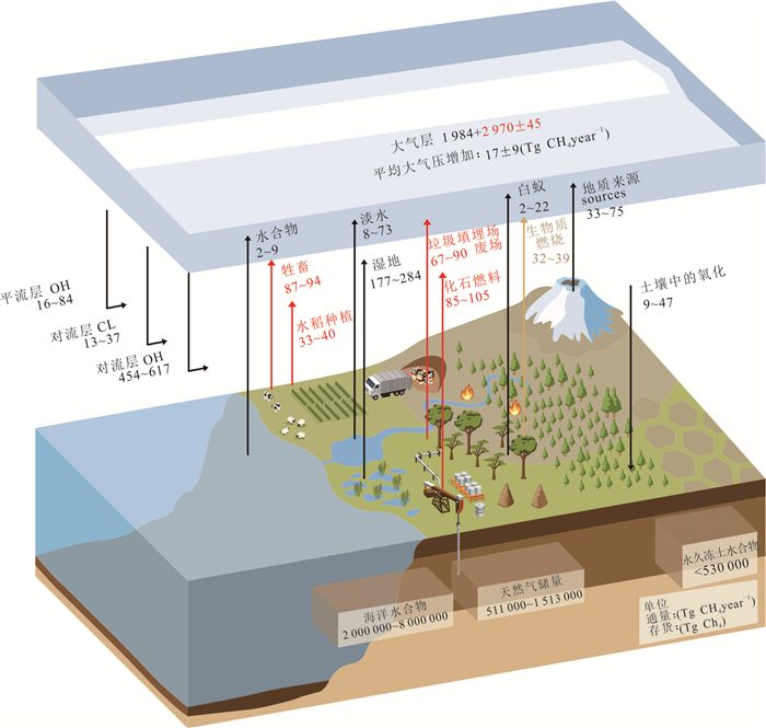
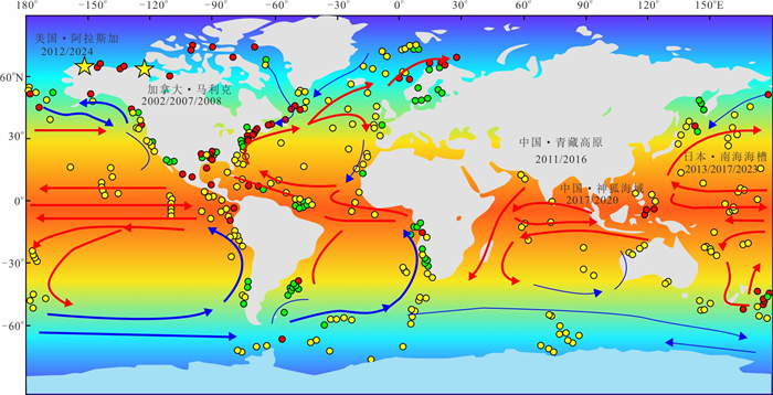
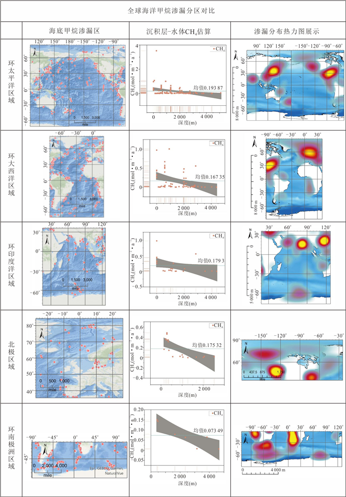
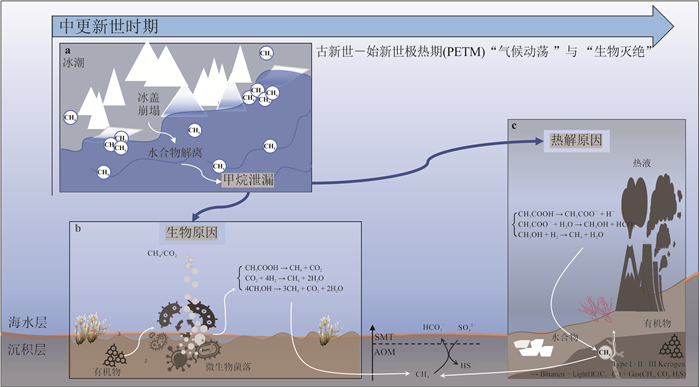
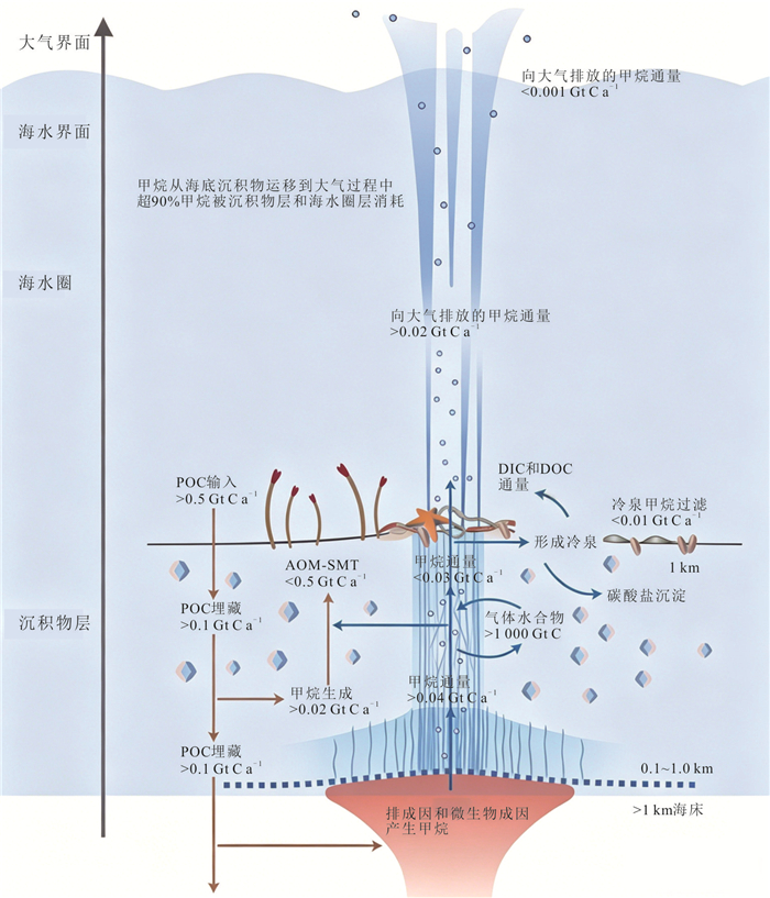
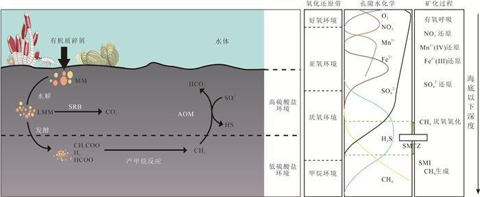
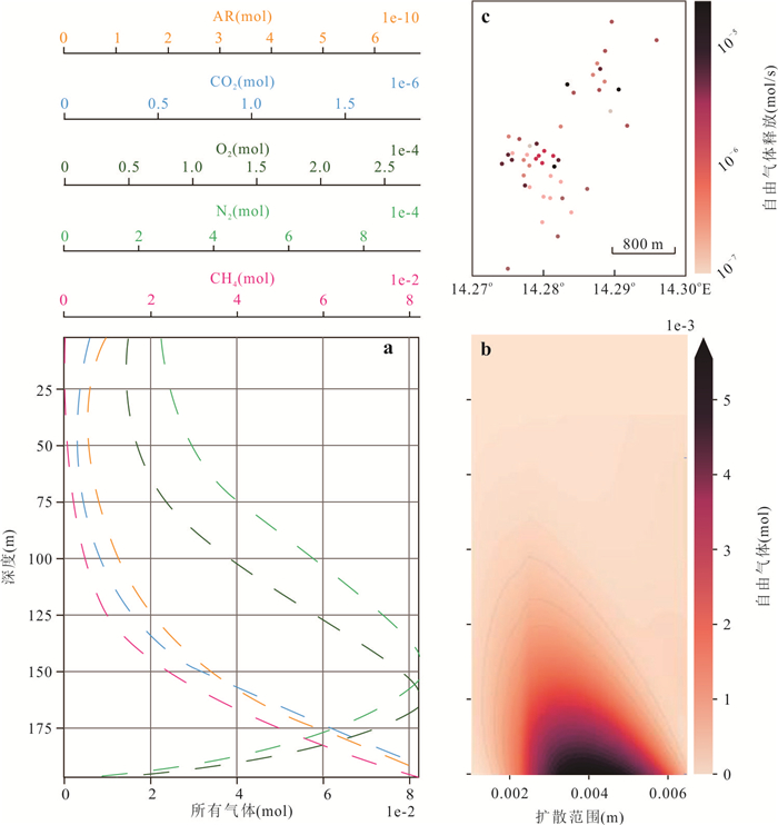
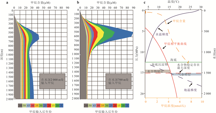
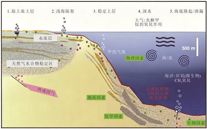
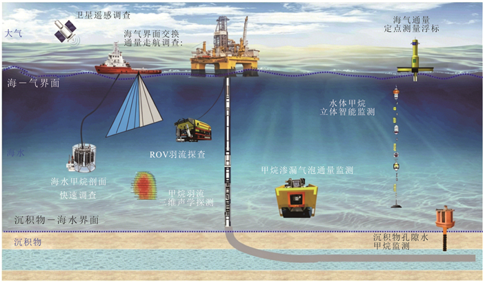
Over a 100-year period, methane has a global warming potential 30 times that of carbon dioxide on a per-molecule basis. As a potent greenhouse gas, methane stored in the ocean accounts for 95% of the global total reserves, and the processes of methane sources and sinks directly influence global climate change. In this paper, the spatial distribution pattern and transport and diffusion mechanism of global marine methane leakage are systematically investigated through literature research and data analysis, and the environmental effects are quantitatively assessed by combining the measured data of typical case areas such as the South China Sea and the Gulf of Mexico. The global methane seepage shows significant spatial differences, with the most active seepage in the Pacific Rim, followed by the Arctic and Atlantic coasts, and the lowest in the Antarctic Rim. This distribution pattern is primarily controlled by tectonic activity, conditions within the hydrate stability zone, and the supply of sedimentary organic matter. The actual seepage activity in high-latitude regions such as the Arctic may be underestimated, representing a major source of oceanic methane in the atmosphere. Approximately 70%-90% of seafloor methane seepage is oxidized and consumed by microorganisms, but 1.5%-4% enters the atmosphere directly, contributing 6-12 Tg per year. Seafloor methane seepage has significant impacts on the global environment through ocean acidification, ecological restructuring, and greenhouse gas emissions. Dynamic monitoring and research and development of methane negative emission technologies should be strengthened to serve the dual carbon goals and global climate governance.
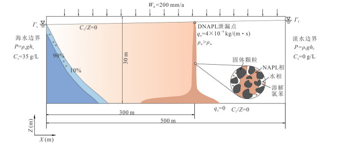
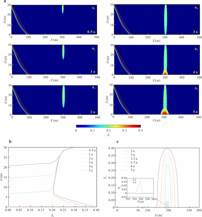
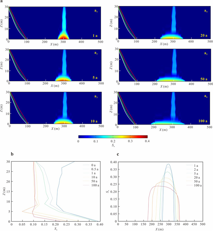
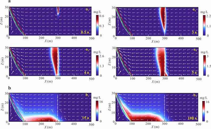
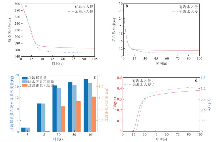
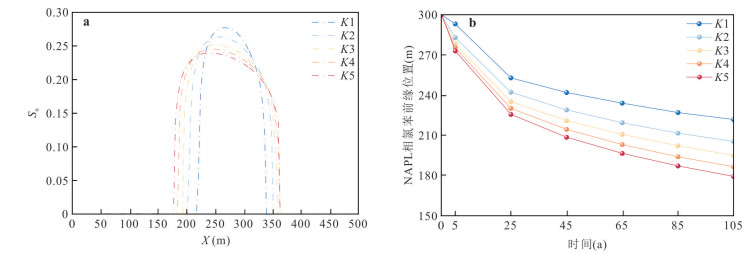
To reveal the regulatory mechanism of the variable-density flow field induced by seawater intrusion on the multiphase migration pathways and interphase mass exchange of dense non-aqueous phase liquids (DNAPL), this study developed a coupled variable-density flow, multiphase flow, and solute transport numerical model using chlorobenzene as an example, systematically simulating its infiltration, redistribution, and dissolved plume evolution. The results indicate follows: (1) The NAPL-phase chlorobenzene vertically infiltrates under gravity-dominated conditions, forming an asymmetric contaminant pool above the aquitard. (2) The saltwater wedge significantly alters the migration pathway of dissolved-phase chlorobenzene, with density gradients driving its upward movement along the freshwater-saltwater interface and accumulation in the mixing zone, while the peak discharge flux to the sea decreased by 62% compared to the scenario without seawater intrusion. (3) An increase in hydraulic conductivity (K) accelerates the migration of both NAPL-phase and dissolved-phase chlorobenzene toward the marine boundary, while enhancing the accumulation of the dissolved phase within the mixing zone. This study elucidates the retention mechanism of the mixing zone for DNAPL migration and confirms that this zone represents a non-negligible long-term secondary pollution source in coastal groundwater environmental risk assessments.
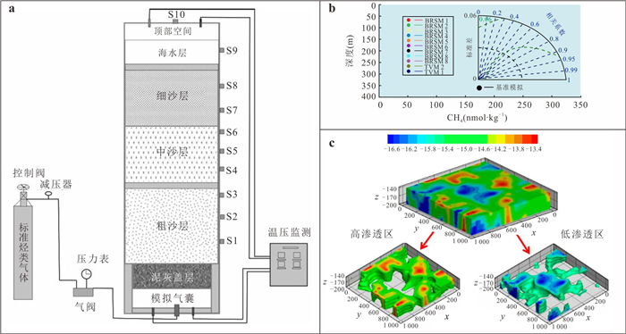
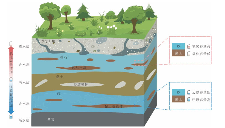
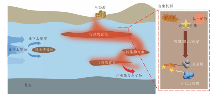
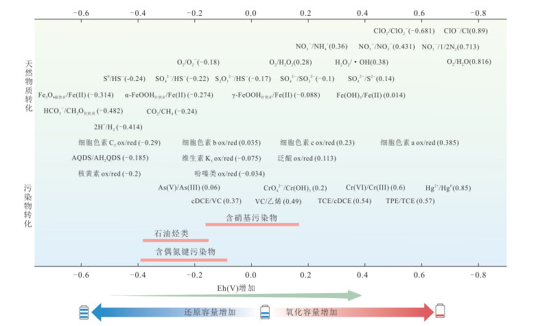
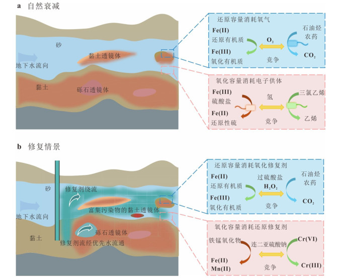
Porous aquifer heterogeneity is a fundamental factor constraining the efficiency of groundwater remediation at contaminated sites. This study clarified the concepts of structural heterogeneity and redox heterogeneity, and systematically analyzed the mechanisms of heterogeneity governing the transport and transformation of contaminants and remediation reagents.Structural heterogeneity primarily controls contaminant transport and the delivery and dispersion of remediation reagents. Permeability difference within aquifers commonly results in remediation blind zones in low-permeability regions as amendment penetration is limited. This may lead to contaminant rebound during the later stage of remediation due to back diffusion. Redox heterogeneity, characterized by spatial variations in redox capacity, mainly influenced contaminant transformation and remediation reagent consumption through its involvement in electron transfer processes. Consequently, the effects of redox capacity must be explicitly considered in the selection of remediation technologies and the design of operational parameters. Finally, key challenges associated with the remediation of heterogeneous aquifers are identified, and future research directions are proposed based on a synthesis of existing mitigation strategies.
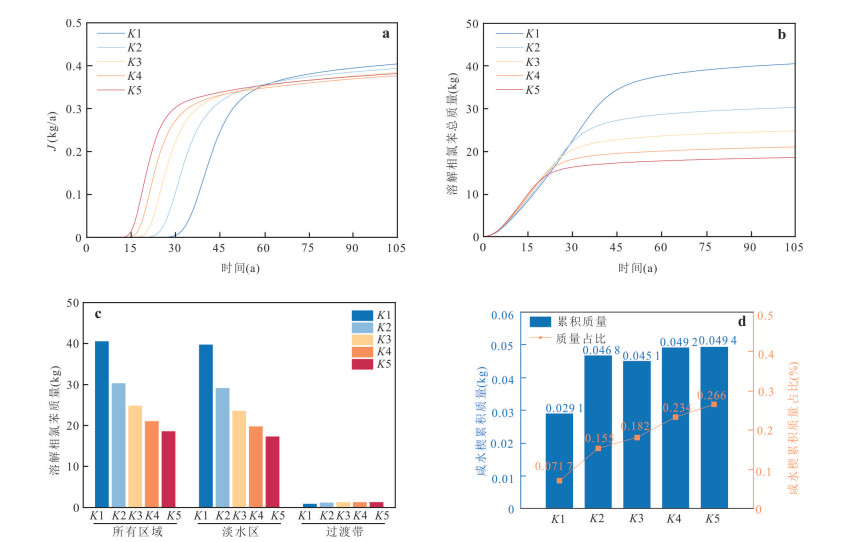
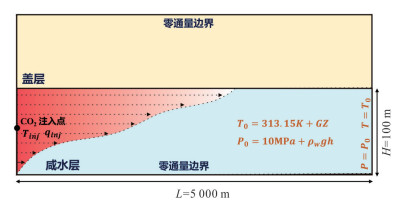
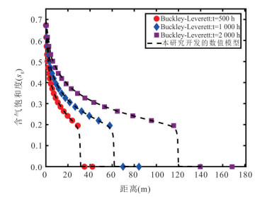
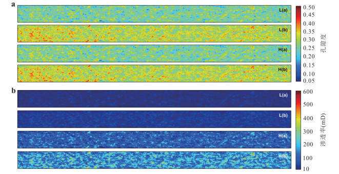
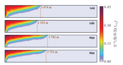
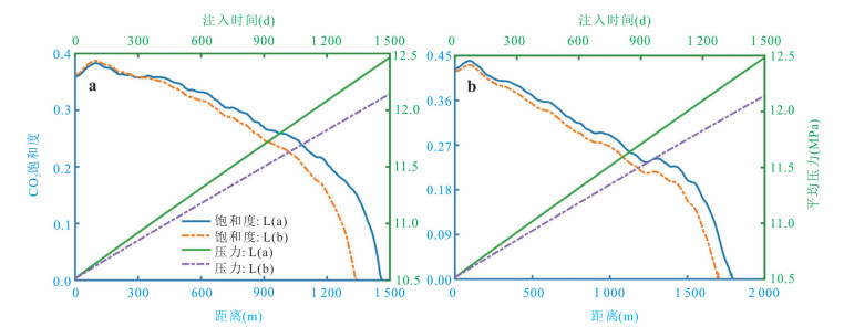
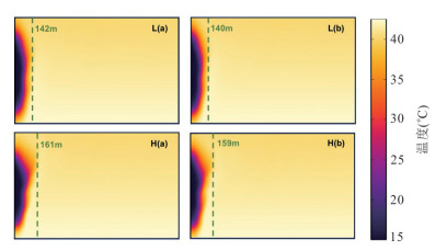
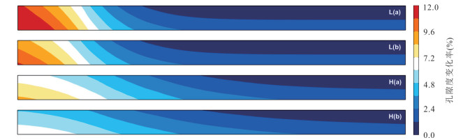
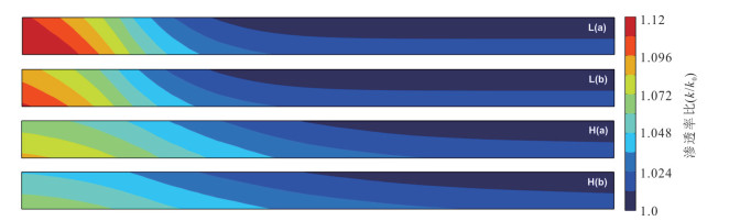
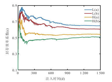
A deep understanding of reservoir heterogeneity and multi-field coupling effects is important for assessing CO2 flow and migration behavior during geological CO2 storage. This study comprehensively considers the two-phase flow mechanism, the dynamic evolution of reservoir porosity and permeability structures, and the influence of temperature on the physical properties of CO2 under non-isothermal conditions. A thermal-hydraulic-gas-mechanical (THGM) coupled model is developed to investigate CO2 migration behavior and storage efficiency behavior in heterogeneous saline aquifers. Simulation results indicate that reservoir heterogeneity significantly influences average pressure build-up within the reservoir. In low-porosity reservoirs, the increase in pore pressure is approximately 1.96 MPa, whereas in higher-porosity reservoirs, it is only approximately 1.64 MPa, thereby affecting the physical properties and migration pathways of injected CO2. Additionally, the maximum migration distance of the thermal front is only approximately 161 m, while the maximum lateral migration distance of the CO2 plume can reach approximately 1 782 m. The permeability and porosity within the reservoir vary at a ratio of approximately 1.01-1.13 and an amplitude of 2.10%-12.8% during CO2 injection, respectively. The porosity and permeability of low-permeability reservoirs is more sensitive to pressure disturbances. The maximum CO2 storage efficiency factor reached approximately 0.88 in low-permeability heterogeneous reservoirs, significantly higher than those in high-permeability reservoirs, demonstrating that maintaining an injection rate below the rock fracture pressure in such formations helps enhance the effective storage capacity and long-term stability of CO2.
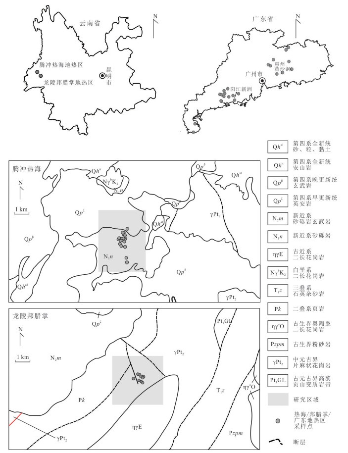
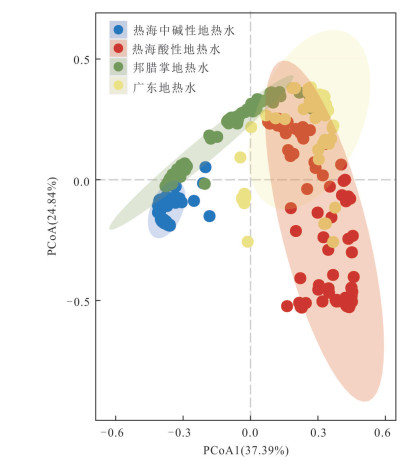
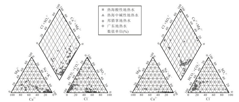
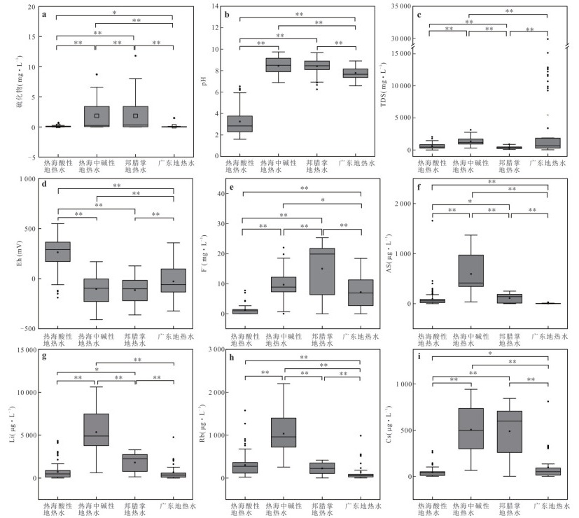
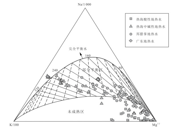
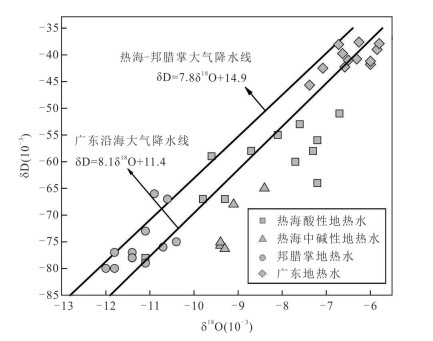
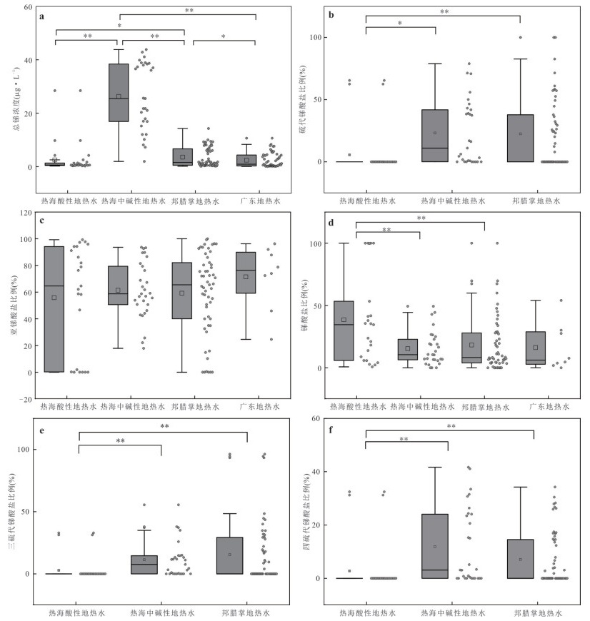
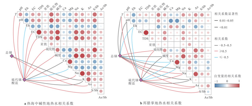
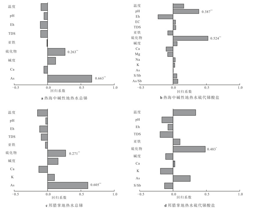
To understand the distribution characteristics, controlling factors and significance of total antimony and antimony species in different types of geothermal water, geothermal areas in Tengchong Rehai and Longling Banglazhang in Yunnan, as well as various geothermal areas in Guangdong, were selected. this study systematically compared the concentration of total antimony and antimony species, along with their controlling factors, across three distinct geothermal system scenarios: those with intra-crustal magma chamber receiving magmatic fluid input; those with intra-crustal magma chamber but without magmatic fluid input; and those without intra-crustal magma chamber. The results indicate that total antimony content is related to the genesis of geothermal water; meanwhile, enrichment of sulfide coupled with elevated pH constitutes a critical prerequisite for formation of thioantimonate. Overall, the distribution of antimony species in geothermal water is controlled by the geochemical environment of the geothermal system and provides some indication of the genesis of geothermal systems: for geothermal waters lacking thioantimonate, direct magmatic fluid input can be ruled out, however, both magmatically influenced and unaffected geothermal waters may yield thioantimonate in sulfide-rich environment.
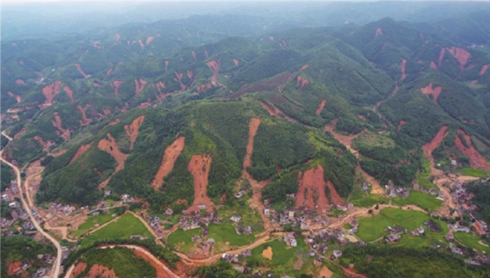
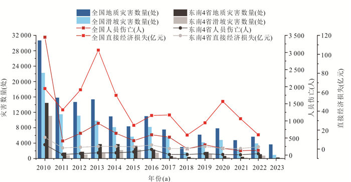
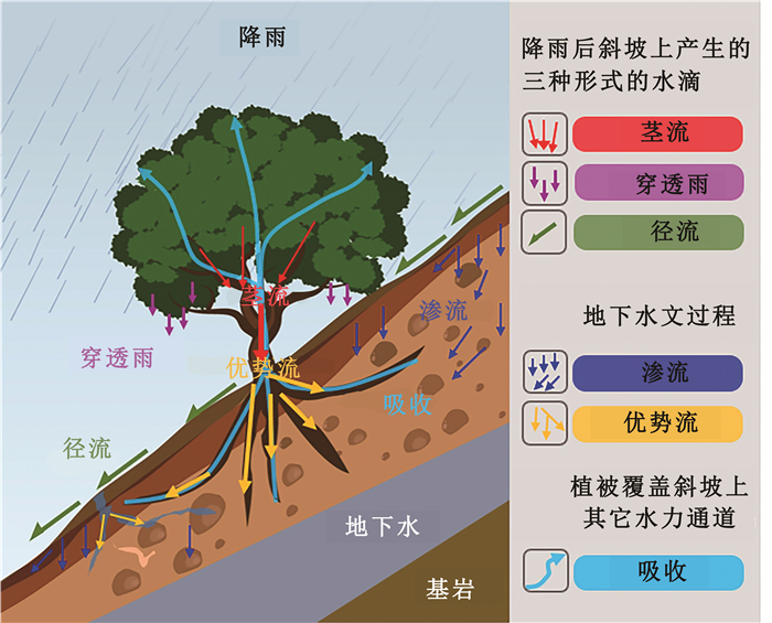
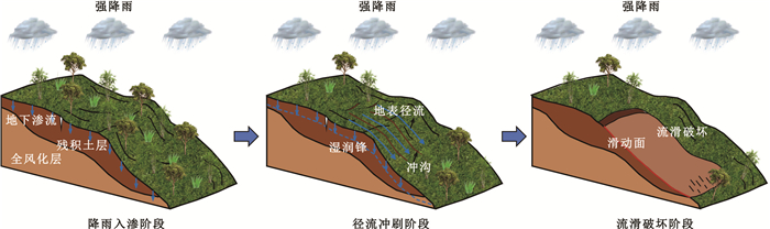
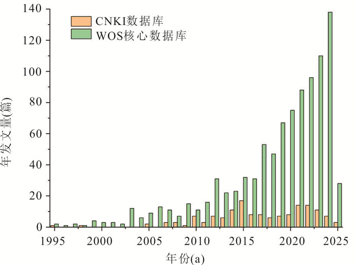
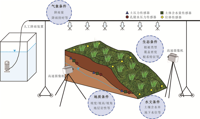
The southeastern region of China is highly susceptible to rainfall-induced cluster landslides. Their formation process is governed by the complex interplay of multiple factors, including geology, meteorology, hydrology, ecology, and human activities, exhibiting significant multi-scale effects. This study systematically reviews the research progress on multi-scale formation mechanisms of rainfall-induced cluster landslides under multi-factor coupling effects, with a focus on analyzing the individual and synergistic mechanisms of geological conditions, meteorological-hydrological processes, ecological environment, and human activities. The differences and connections in landslide formation processes from the individual slope scale to the watershed scale are elaborated. Furthermore, the application status of research methods such as field monitoring, physical model testing, numerical simulation, and artificial intelligence is summarized. The study indicates that understanding multi-factor coupling mechanisms and cross-scale linkages is essential for deciphering the formation patterns of cluster landslides. However, challenges remain, including an unclear understanding of dynamic multi-factor interactions and insufficient integration of models across scales. Future research should strengthen the investigation of the multi-factor coupling mechanisms and collaborative evolution of physical and mechanical processes, promote the development of multi-scale formation models, and enhance capabilities for regional landslide early warning and risk prevention.
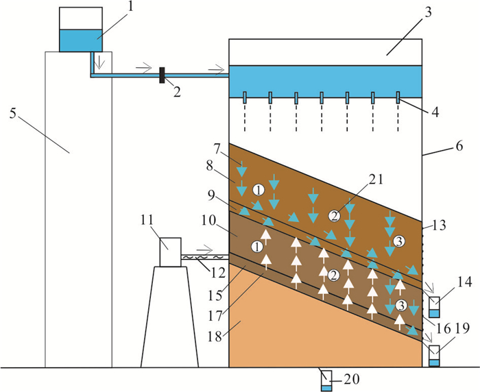
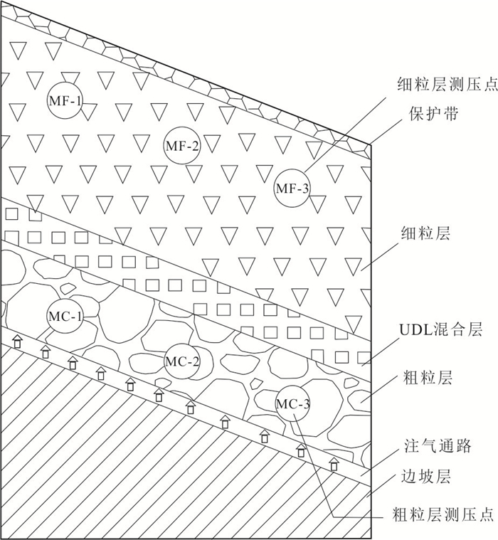
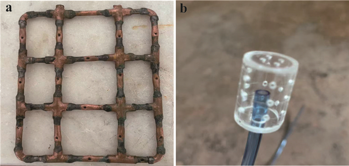
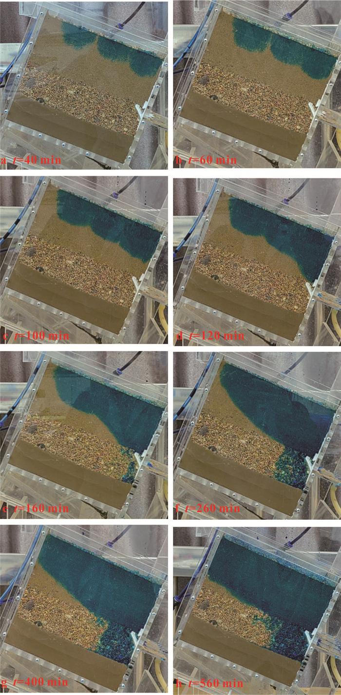
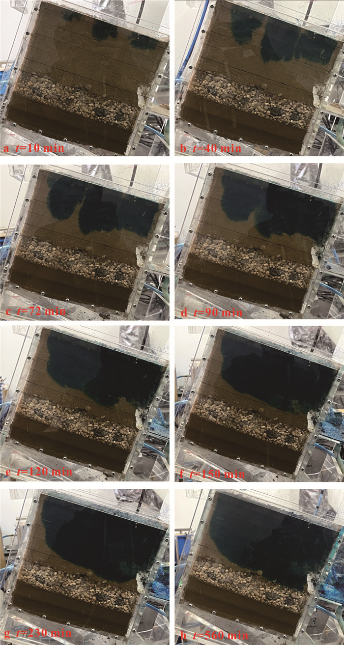
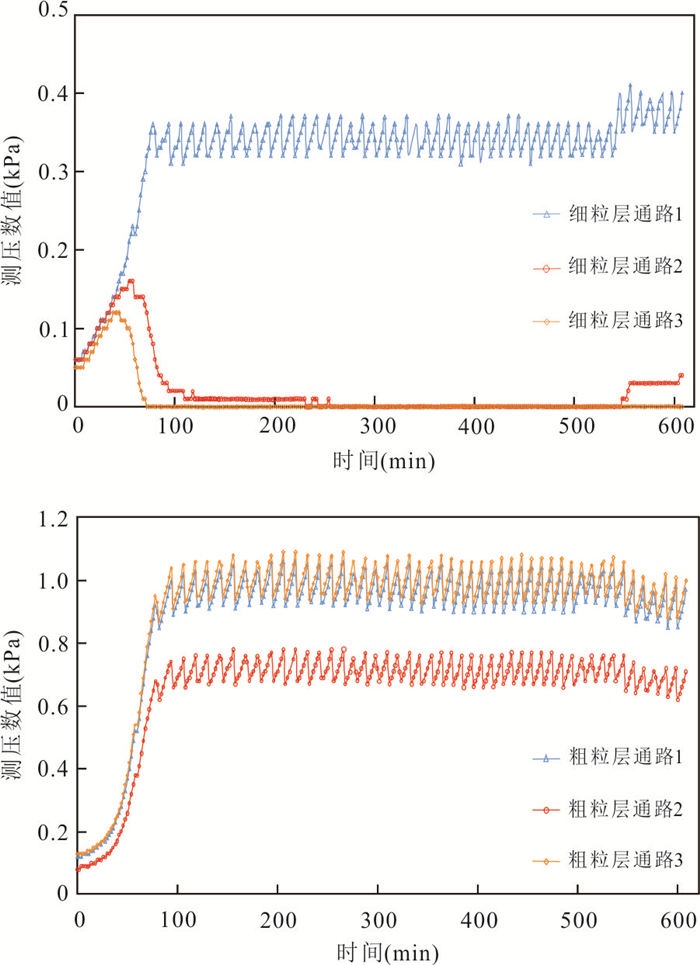
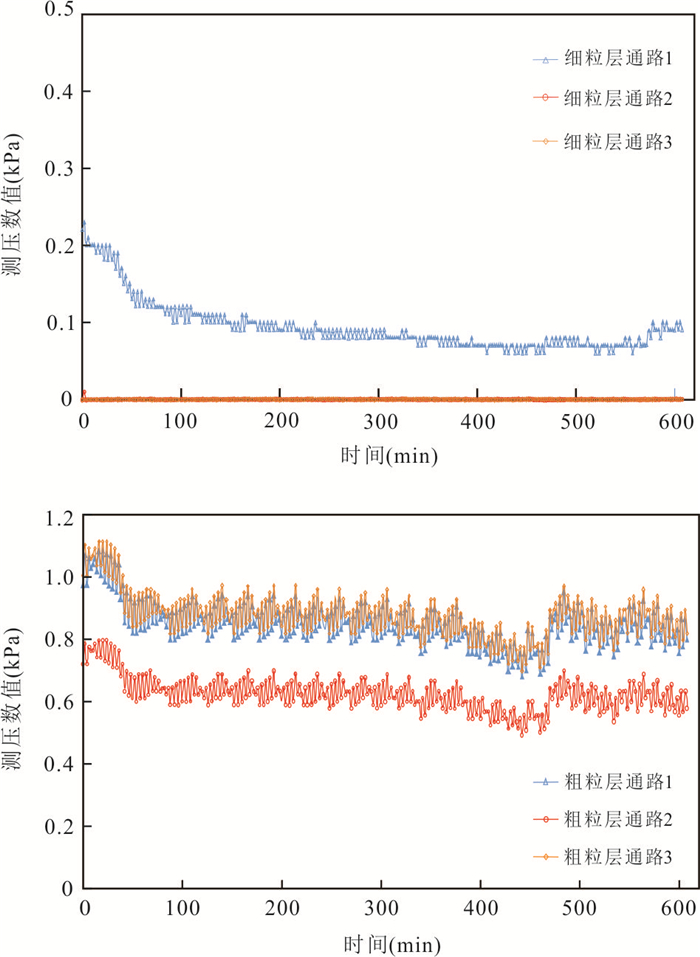
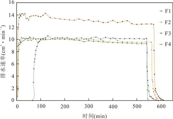
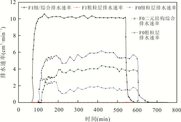
Traditional surface hardening and impermeabilization measures for earthen slopes are prone to desiccation cracking due to rainfall infiltration, threatening engineering safety. The application of an capillary barrier layer (CBL) for protection can enhance the safety and stability of the project. However, its hydraulic conductivity decays with the long-term process of rainfall infiltration.To address the attenuation of capillary barrier strength in conventional unsaturated CBL during rainfall infiltration, this study proposes a method to enhance the infiltration resistance of the unsaturated barrier by pressurizing the coarse-grained layer from a coupled water-gas perspective. A series of physical model tests were conducted to investigate the effects of different rainfall intensities, initial CBL moisture contents, and coarse-grained layer pressurization levels on infiltration resistance. The main findings are as follows. (1) When the coarse-grained layer is pressurized (1-3 kPa), rainfall is entirely discharged along the interface between the fine-grained layer, the transition layer, and the coarse-grained layer, completely preventing rainfall breakthrough into the coarse-grained layer and significantly improving the barrier efficiency of the unsaturated CBL. (2) The steady-state lateral drainage rate of the binary structure increases with higher pressurization in the coarse-grained layer but decreases with increasing moisture content in the fine-grained layer. (3) A Comprehensive Barrier Efficacy Index (CBEI) is proposed to quantify the effectiveness of the unsaturated barrier under air injection conditions. This result innovatively establishes the soil gas phase as the drainage driving force in barrier layers, providing a scientific basis for slope protection engineering.
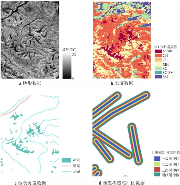
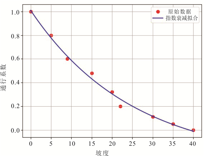
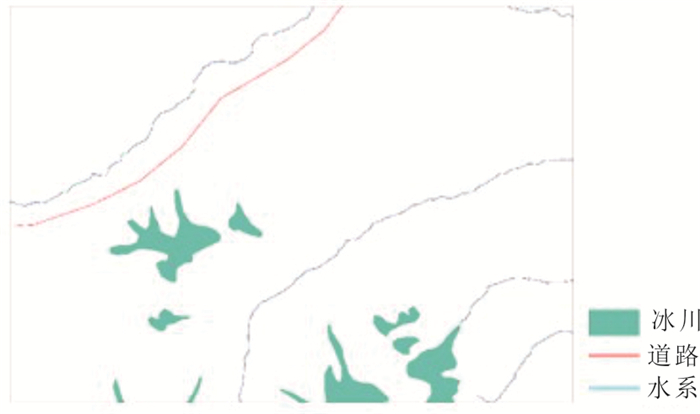
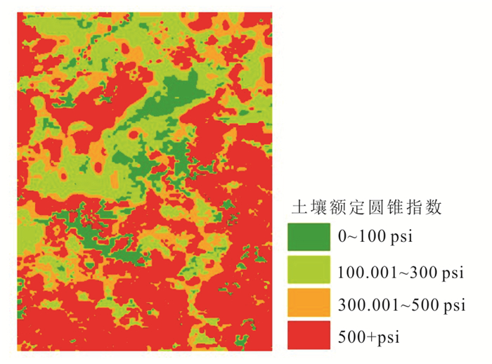
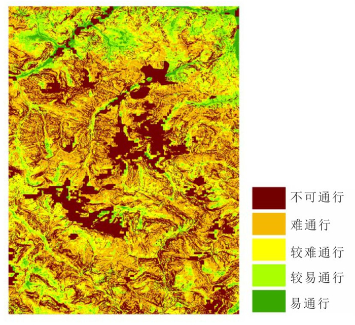
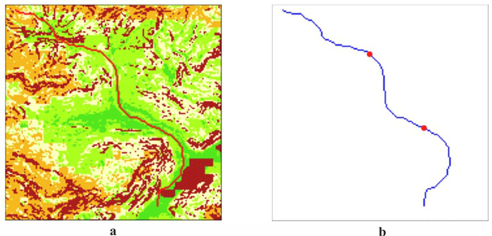
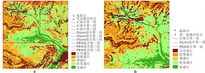
Off-road path planning plays a strategically important role in special mission scenarios such as emergency rescue. However, existing algorithmic models often suffer from low accuracy in passability modeling and poor computational efficiency in complex terrains. To improve planning accuracy and efficiency, this study introduces the Soil Moisture-Strength Prediction model (SMSP Ⅱ) to estimate the rated cone index (RCI) of soil, and combines it with the vehicle cone index (VCI) to construct a traversability grid map that integrates multiple constraints and soil passability indicators. On this basis, an improved NSGA-Ⅱ algorithm is proposed, incorporating a divide-and-conquer strategy and heuristic search, and is further integrated with the Dijkstra algorithm to build a multi-level hybrid path optimization framework. Experimental results demonstrate that the proposed method improves computational efficiency by approximately 45%, enhances path passability by 2%, and reduces path length by about 2.1%, while maintaining path feasibility. The findings verify the superior performance of the proposed technical framework for off-road path planning in complex geological environments.
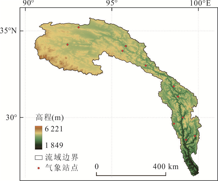
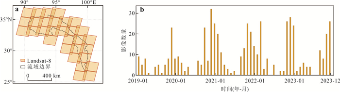
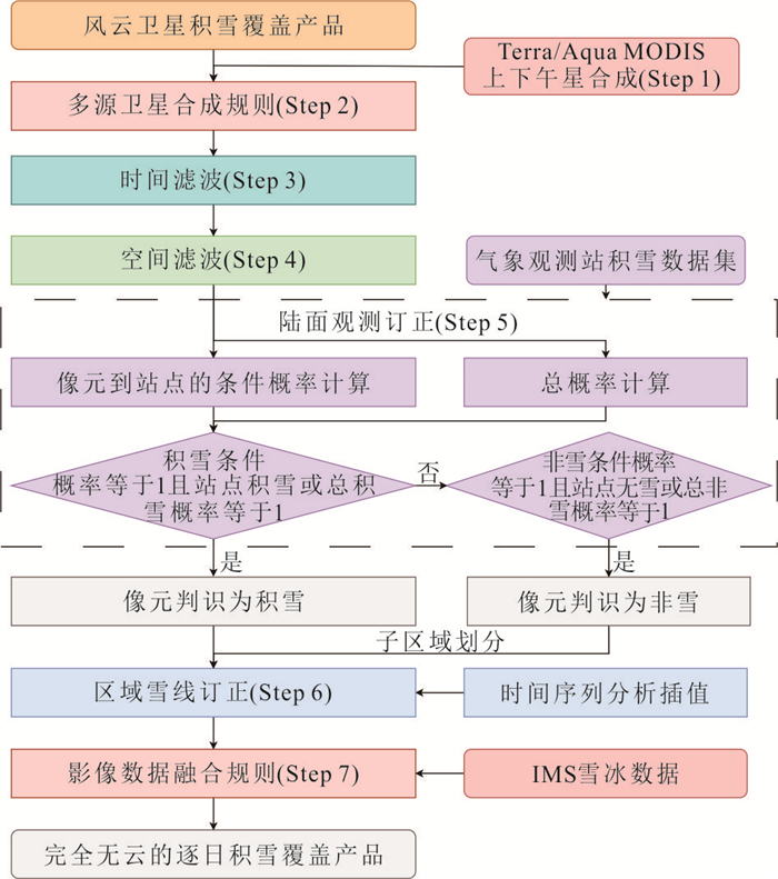
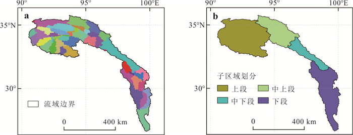
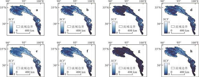
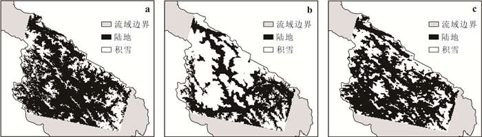
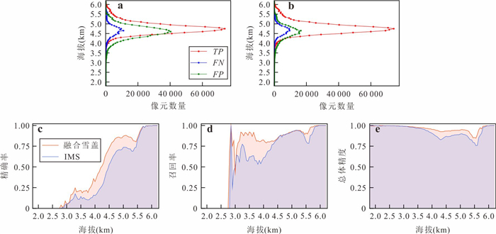
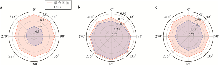
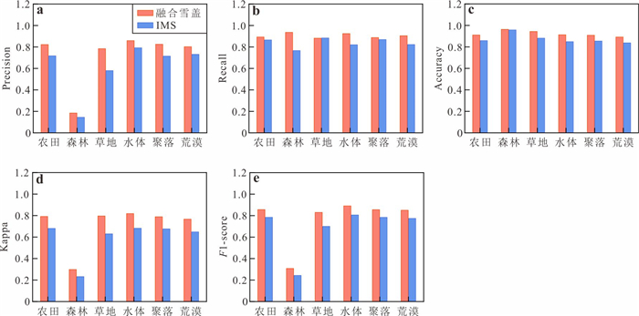
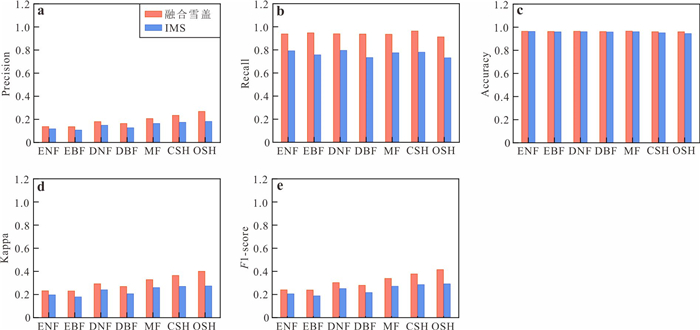
To address the issue of missing data in snow cover products caused by cloud contamination in remote sensing imagery, this study proposes a snow cover reconstruction method based on the fusion of multisource data, including Fengyun satellite observations. A seven-step cloud removal process was employed to achieve daily, accurate, cloud-free snow cover monitoring in the upper Jinsha River basin. The results indicate that the reconstructed snow cover product attains an overall accuracy of 0.94 and a Kappa coefficient of 0.80, outperforming the widely used IMS product from the United States. However, the overall accuracy slightly declines within snow transition zones at altitudes of approximately 4.3 km and 5.6 km, and it varies according to slope aspect. Moreover, the precision of the reconstructed product in forested areas is considerably lower (0.18) than in other land cover types. Future enhancements to the reconstruction method should incorporate slope aspect and forest-specific characteristics to improve the accuracy of multisource fused, cloud-free snow cover products.


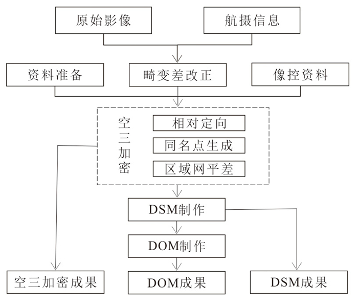
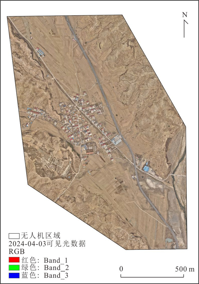
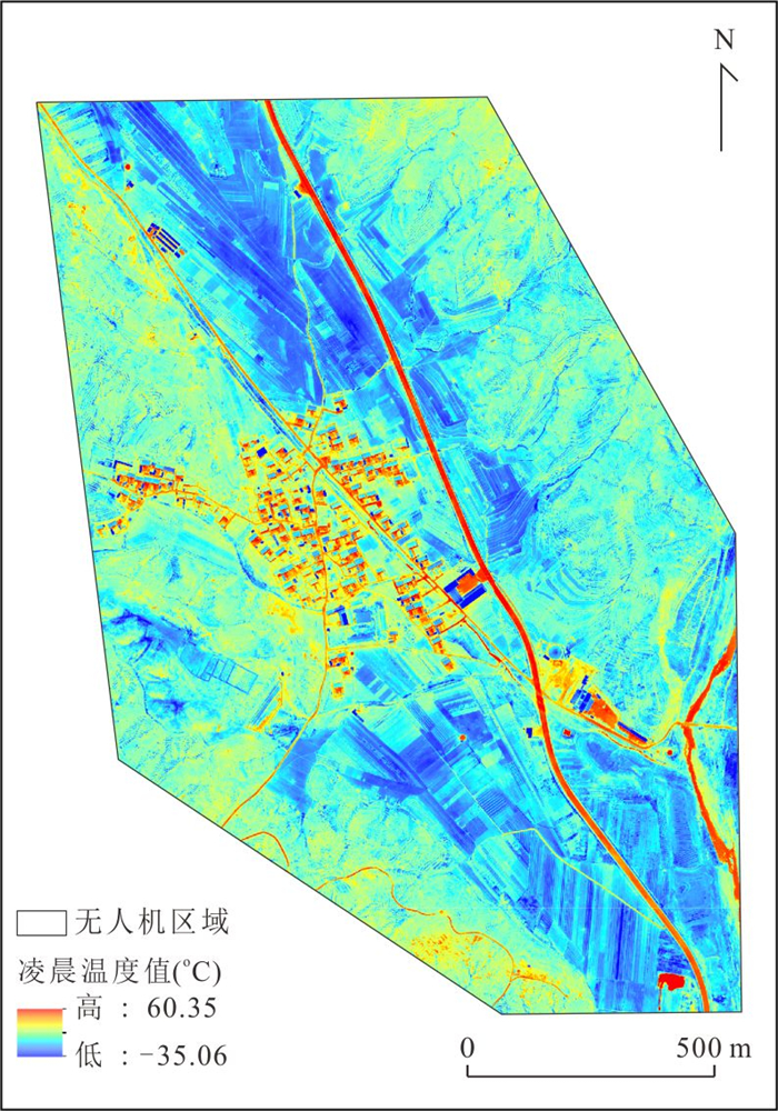
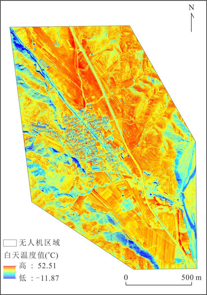
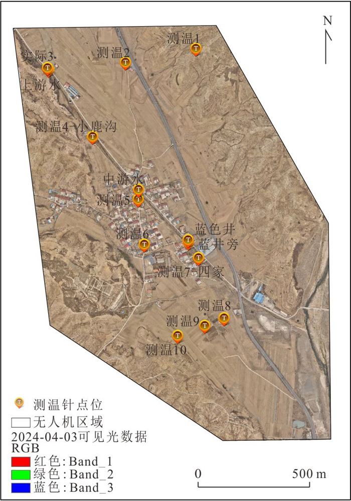
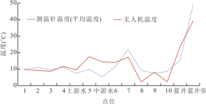
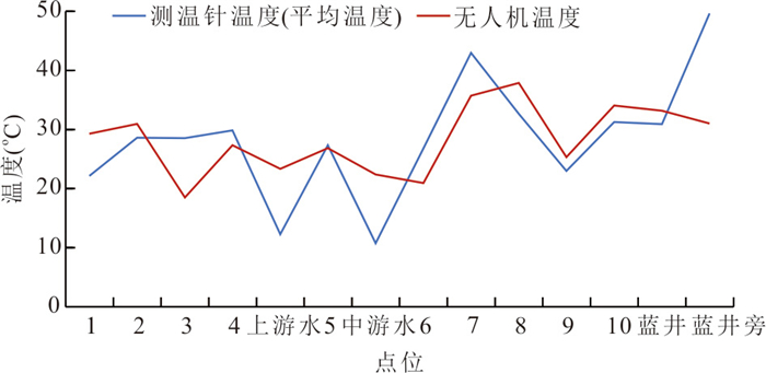
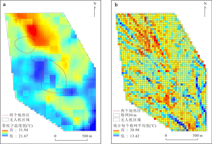
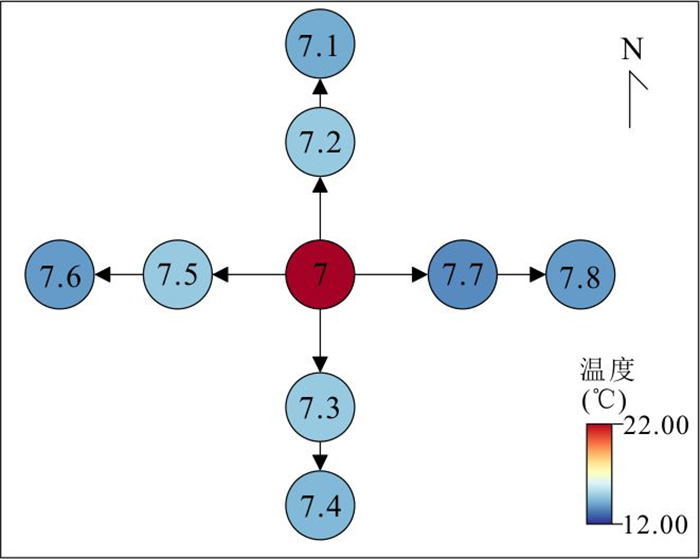
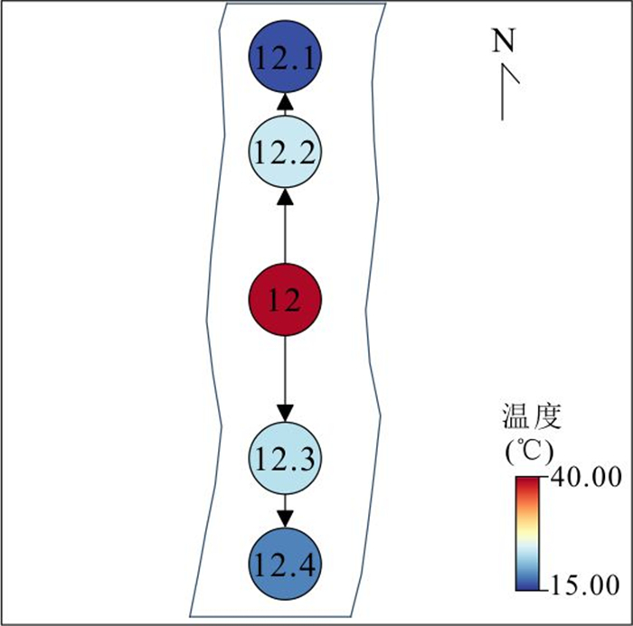
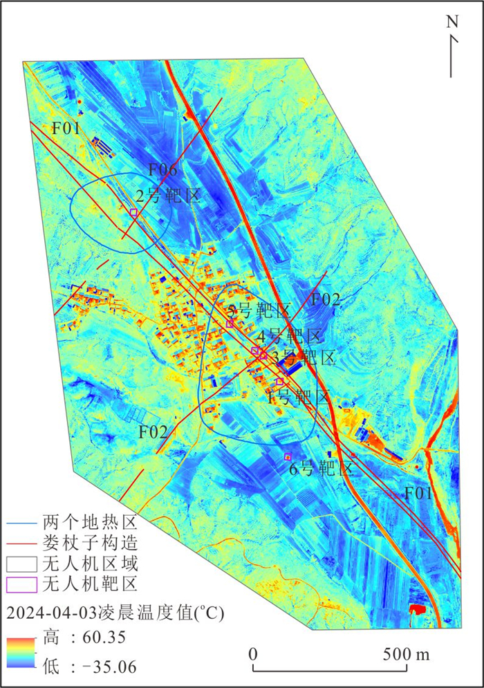
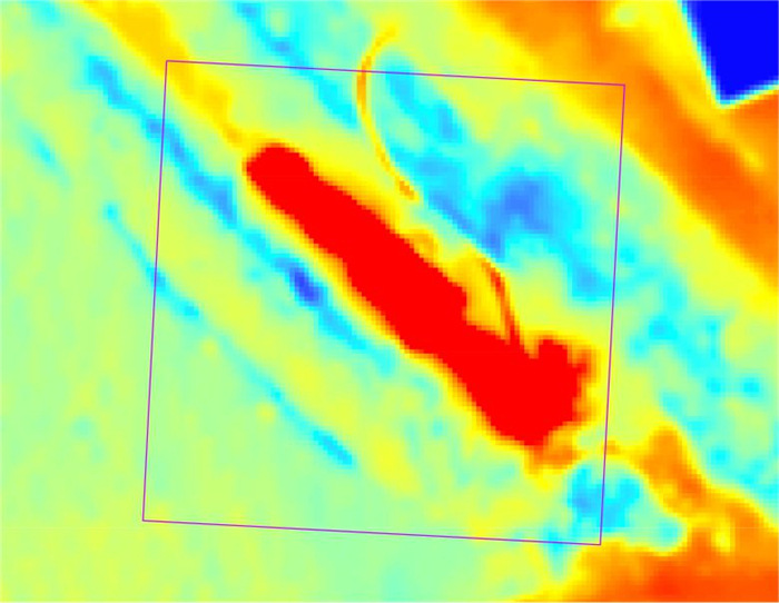
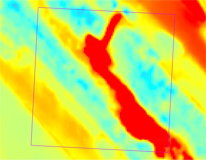
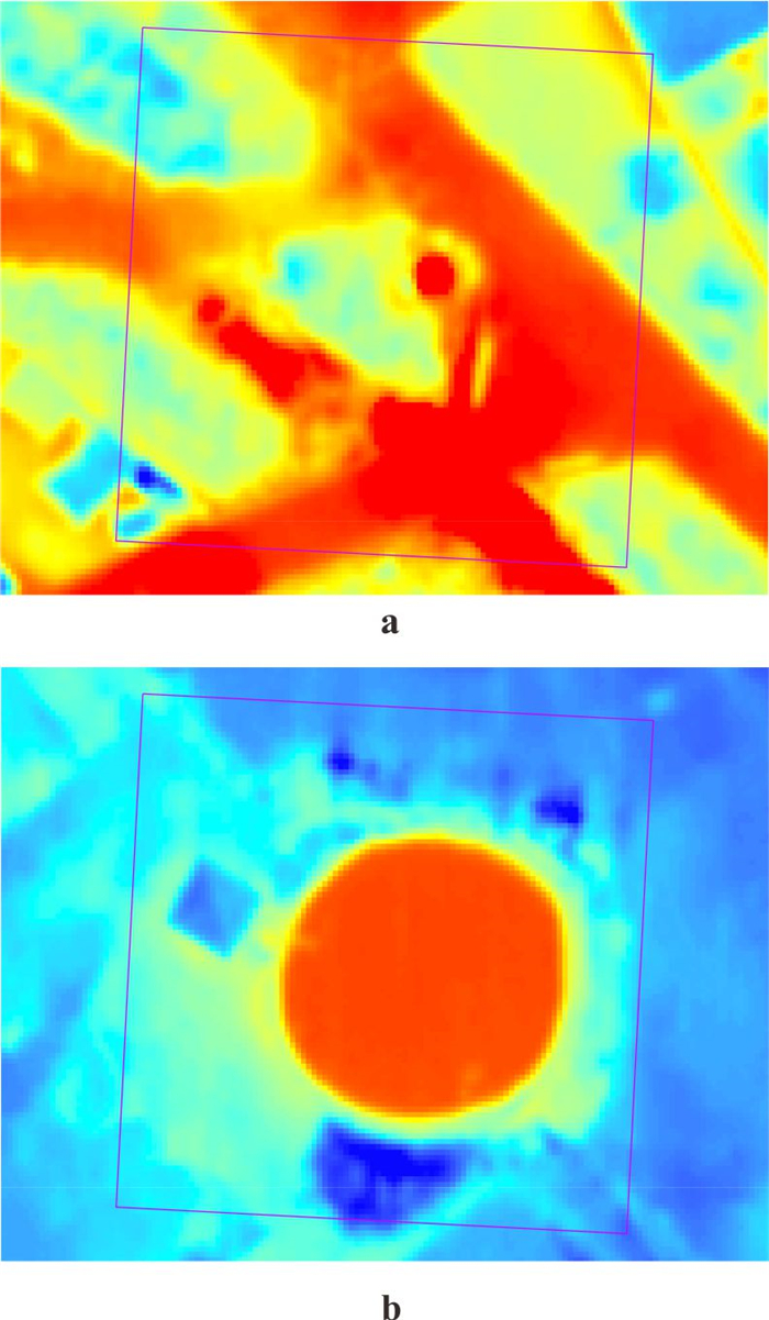
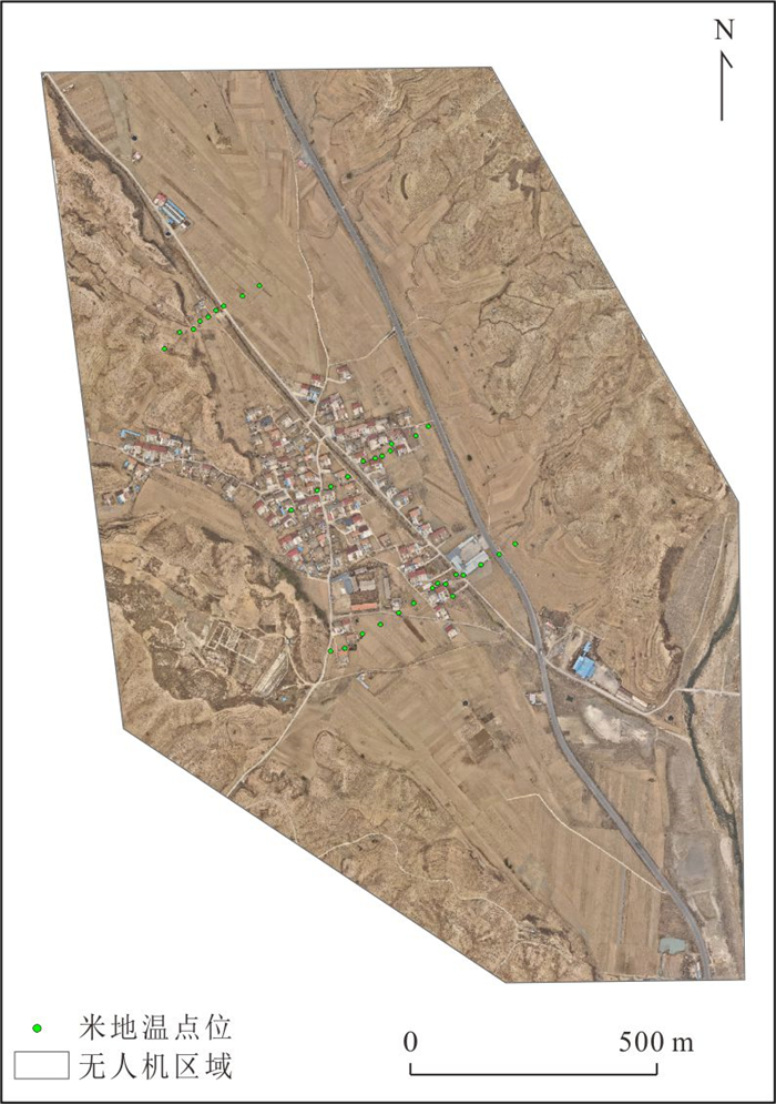
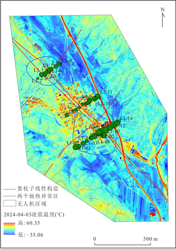
In view of the low spatial resolution and strong susceptibility to solar radiation effects of satellite-based thermal infrared remote sensing in geothermal exploration, this study employs a DJI Mavic 3T unmanned aerial vehicle to acquire high-resolution true-color and thermal infrared imagery over the study area. An automated land surface temperature retrieval workflow was developed based on the DJI Thermal SDK to obtain UAV-derived surface temperature data. Validation using in situ temperature measurements demonstrates that the UAV-retrieved temperatures exhibit a high degree of consistency with the observed temperature variation trends at ground sampling points. After resampling the UAV thermal infrared imagery to 30 m, the retrieved temperatures show strong spatial agreement with those derived from Landsat-8 TIRS data. Based on the proposed "cross-shaped" and "linear" geothermal target delineation patterns, six potential geothermal targets were identified by integrating the regional structural framework with the spatial distribution characteristics of thermal anomalies. Furthermore, the geothermal genesis of the delineated targets was analyzed through the combined use of measured shallow ground temperature data and existing geological information. The results indicate that UAV-based thermal infrared technology enables high-precision identification of geothermal anomalies in complex mountainous terrains, providing effective technical support for small-scale geothermal target delineation and resource potential assessment. Future work should incorporate multi-depth ground temperature measurements and shallow heat diffusion models to strengthen the quantitative linkage between surface thermal anomalies and deep geothermal heat sources.