2026 Vol. 51, No. 7
Display Method:
2026, 51(7): 2445-2461.
doi: 10.3799/dqkx.2026.208
 PDF 8828KB
Abstract:
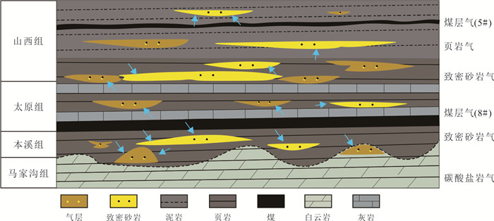
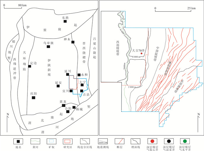
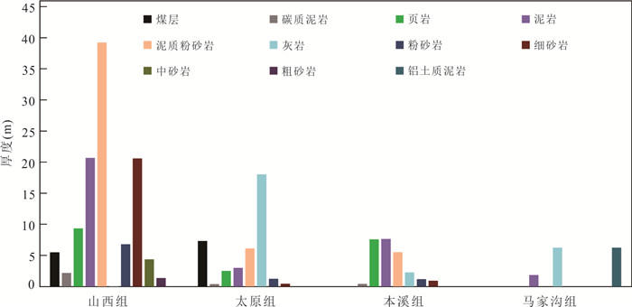
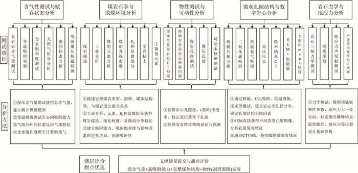
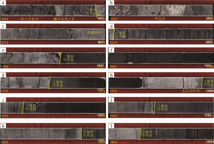
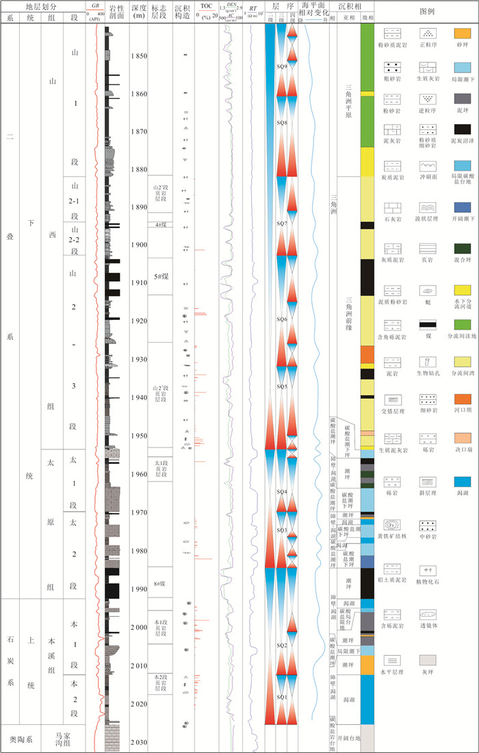
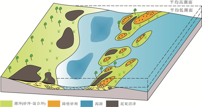
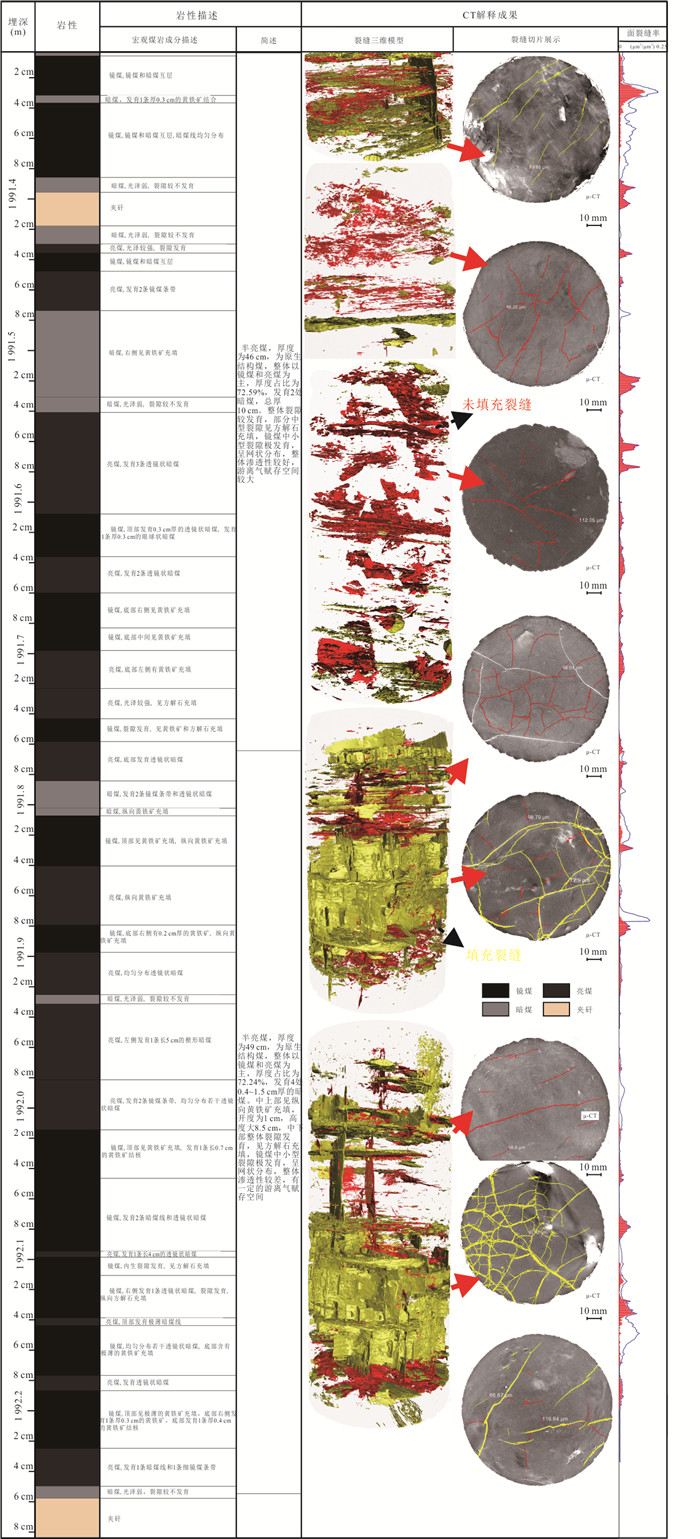
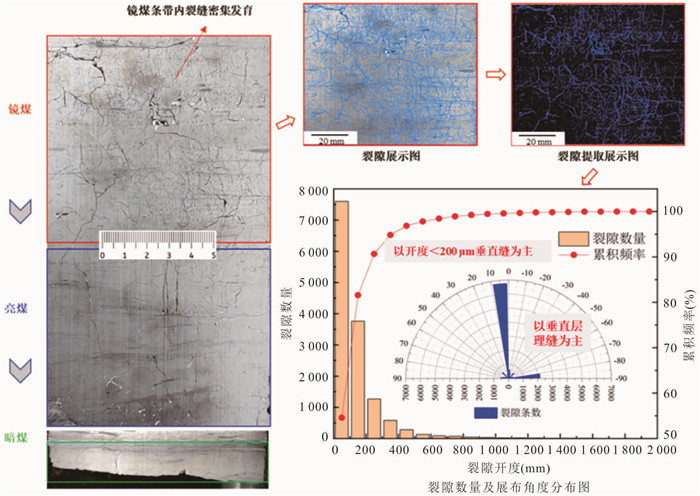
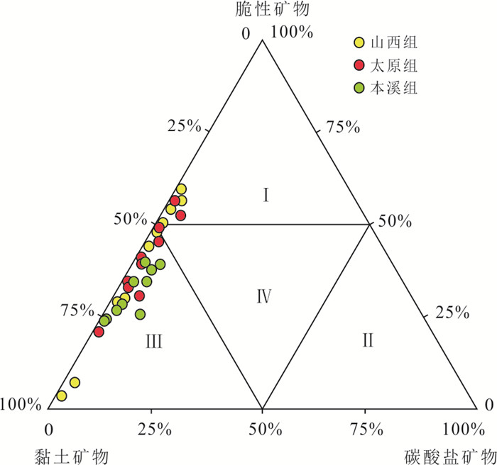
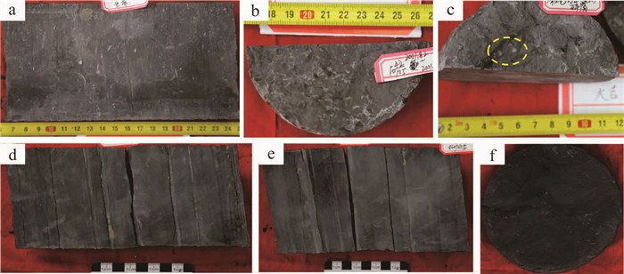
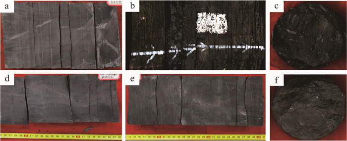
To establish a stratigraphic benchmark for the Carboniferous-Permian formation, Well Daji 70 was deployed and drilled in the Daji area on the eastern margin of the Ordos Basin. This well cored a total of 189 m from 1 843.27 m to 2 032.27 m, achieving a 100% core recovery rate. Through centimeter-scale detailed core description, multi-scale CT scanning, geochemical testing and analysis, combined with geophysical response characteristics, an isochronous stratigraphic framework for the Late Carboniferous to Early Permian on the southeastern margin of the Ordos Basin was constructed. This clarified the spatial configuration of sedimentary systems, laying the foundation for sedimentary environment research. It revealed that the No. 5 and No. 8 coal seams, as well as thin coal seams such as No. 4 and No. 6, are dominated by semi-bright to bright coal with a highly developed natural fracture network (fracture porosity 1.17%-1.19%), effectively supporting the understanding of reservoir formation characterized by "high gas content, high saturation, and high free gas." Additionally, five sets of high-quality shale intervals were identified in the Benxi Formation to Shanxi Formation, providing direct geological evidence for breakthroughs in transitional marine-terrestrial shale gas exploration. The establishment of the "Iron Pillar" in Well Daji 70 not only directly verified and supported the exploration breakthrough of deep coalbed gas in the Daji block but also revealed multiple shale gas replacement layers, offering critical geological evidence and decision-making support for efficient exploration and development in the Ordos Basin.
To establish a stratigraphic benchmark for the Carboniferous-Permian formation, Well Daji 70 was deployed and drilled in the Daji area on the eastern margin of the Ordos Basin. This well cored a total of 189 m from 1 843.27 m to 2 032.27 m, achieving a 100% core recovery rate. Through centimeter-scale detailed core description, multi-scale CT scanning, geochemical testing and analysis, combined with geophysical response characteristics, an isochronous stratigraphic framework for the Late Carboniferous to Early Permian on the southeastern margin of the Ordos Basin was constructed. This clarified the spatial configuration of sedimentary systems, laying the foundation for sedimentary environment research. It revealed that the No. 5 and No. 8 coal seams, as well as thin coal seams such as No. 4 and No. 6, are dominated by semi-bright to bright coal with a highly developed natural fracture network (fracture porosity 1.17%-1.19%), effectively supporting the understanding of reservoir formation characterized by "high gas content, high saturation, and high free gas." Additionally, five sets of high-quality shale intervals were identified in the Benxi Formation to Shanxi Formation, providing direct geological evidence for breakthroughs in transitional marine-terrestrial shale gas exploration. The establishment of the "Iron Pillar" in Well Daji 70 not only directly verified and supported the exploration breakthrough of deep coalbed gas in the Daji block but also revealed multiple shale gas replacement layers, offering critical geological evidence and decision-making support for efficient exploration and development in the Ordos Basin.

2026, 51(7): 2462-2481.
doi: 10.3799/dqkx.2026.207
Abstract:
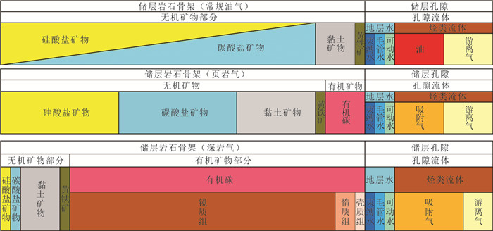
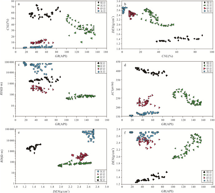
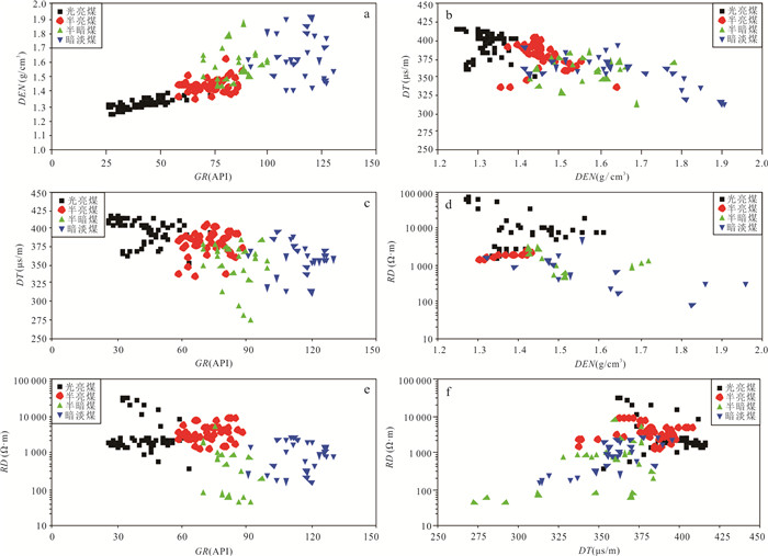
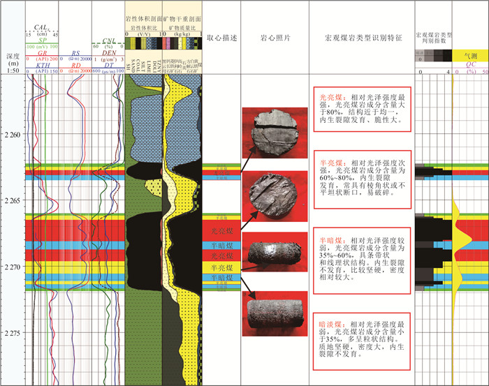
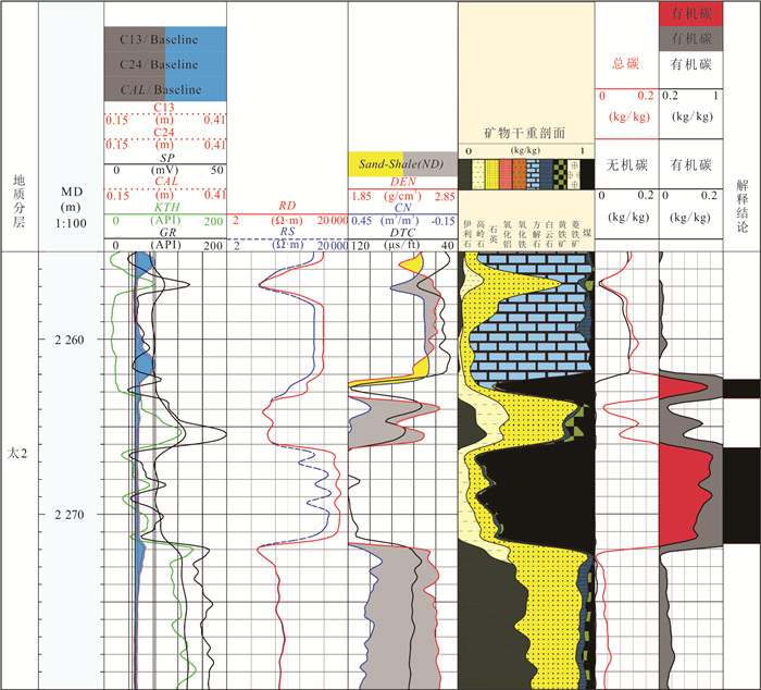
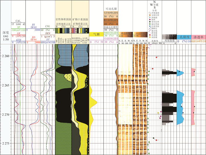
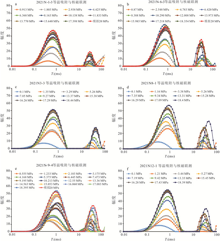
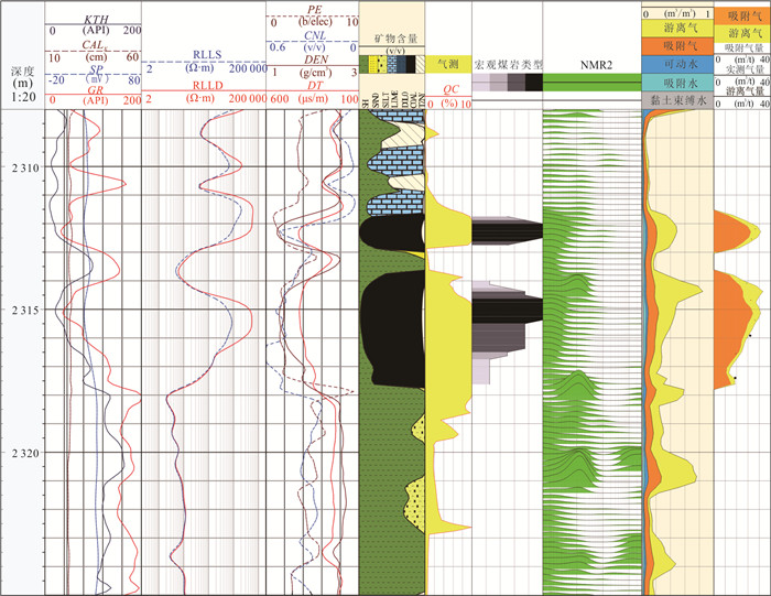
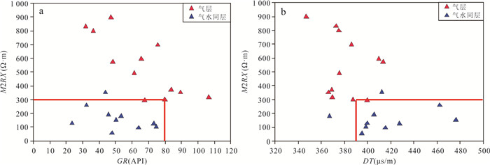
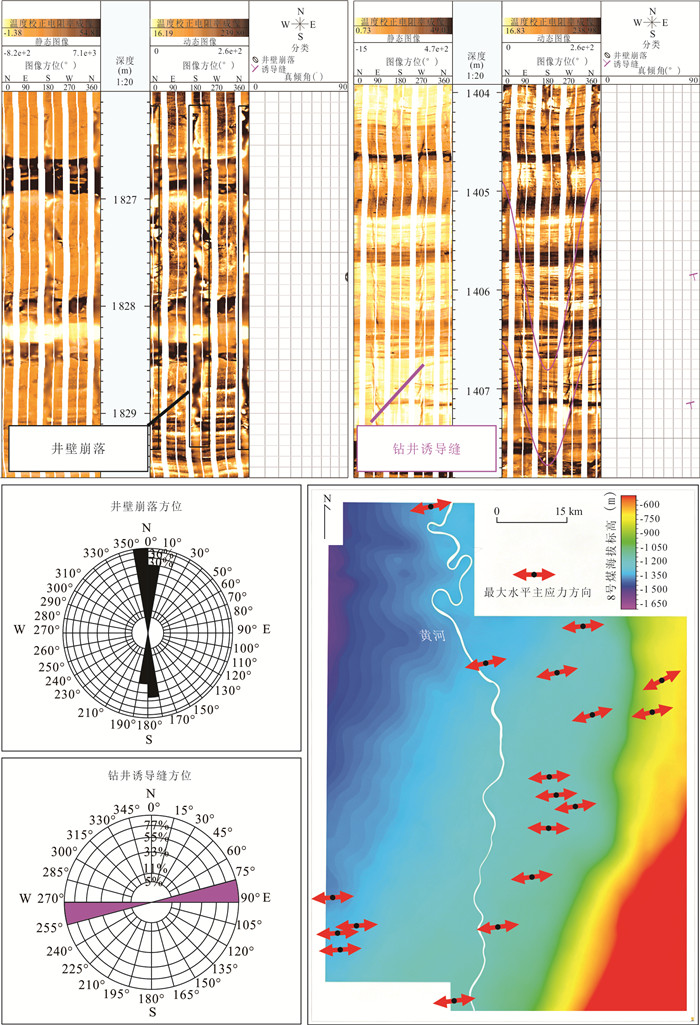
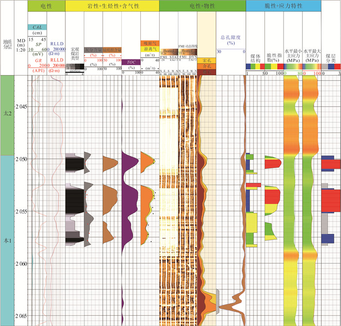
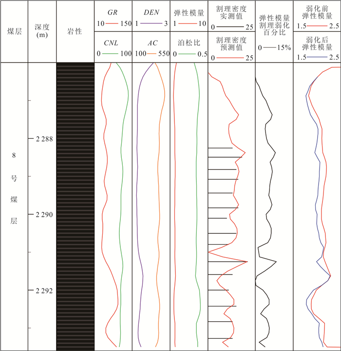
To address the high temperature and pressure, strong heterogeneity, complex pore-fracture system, and significant in-situ stress constraints of deep coalbed methane reservoirs, this study establishes a geological-engineering collaborative evaluation framework based on six properties: lithology, hydrocarbon generation potential, petrophysical properties, gas-bearing property, fracability, and stress characteristics. The results show that lithology is characterized by low natural gamma, low density, high neutron response, high acoustic slowness, and relatively high resistivity. Hydrocarbon generation potential can be jointly characterized by elemental logging, density, acoustic, and resistivity logs. Petrophysical properties are controlled by pore-fracture structure and can be identified using density, acoustic, nuclear magnetic resonance, electrical imaging, and resistivity logs. Gas-bearing property is indicated by high resistivity, neutron-density anomaly, and nuclear magnetic resonance response differences. Fracability is constrained by array acoustic, density, and elemental logs, while stress characteristics are evaluated using array acoustic, electrical imaging, and density logs.Based on these understandings, a logging evaluation volume model composed of organic macerals, inorganic minerals, and pore fluids is constructed. Methods are developed for lithology identification, hydrocarbon generation evaluation, porosity and permeability calculation, adsorbed gas and free gas prediction, fracability characterization, and in-situ stress evaluation. Electrical responses are jointly controlled by lithologic composition, hydrocarbon generation evolution, pore-fracture structure, gas-bearing state, fracability, and stress conditions, showing strong comprehensiveness and non-uniqueness. Integrated application of electrical, density, acoustic, nuclear magnetic resonance, elemental, and imaging logs can reduce single-parameter interpretation uncertainty and improve the accuracy of key "six-properties" parameters. Application in the Daji Block shows that high-quality reservoirs are characterized by low ash content, high vitrinite content, relatively intact coal structure, large coal thickness, high gas content, effective pore-fracture systems, favorable fracability, and moderate stress difference, with high-resistivity and high-slowness logging responses. This method provides support for sweet spot prediction, horizontal well deployment, and fracturing interval optimization.
To address the high temperature and pressure, strong heterogeneity, complex pore-fracture system, and significant in-situ stress constraints of deep coalbed methane reservoirs, this study establishes a geological-engineering collaborative evaluation framework based on six properties: lithology, hydrocarbon generation potential, petrophysical properties, gas-bearing property, fracability, and stress characteristics. The results show that lithology is characterized by low natural gamma, low density, high neutron response, high acoustic slowness, and relatively high resistivity. Hydrocarbon generation potential can be jointly characterized by elemental logging, density, acoustic, and resistivity logs. Petrophysical properties are controlled by pore-fracture structure and can be identified using density, acoustic, nuclear magnetic resonance, electrical imaging, and resistivity logs. Gas-bearing property is indicated by high resistivity, neutron-density anomaly, and nuclear magnetic resonance response differences. Fracability is constrained by array acoustic, density, and elemental logs, while stress characteristics are evaluated using array acoustic, electrical imaging, and density logs.Based on these understandings, a logging evaluation volume model composed of organic macerals, inorganic minerals, and pore fluids is constructed. Methods are developed for lithology identification, hydrocarbon generation evaluation, porosity and permeability calculation, adsorbed gas and free gas prediction, fracability characterization, and in-situ stress evaluation. Electrical responses are jointly controlled by lithologic composition, hydrocarbon generation evolution, pore-fracture structure, gas-bearing state, fracability, and stress conditions, showing strong comprehensiveness and non-uniqueness. Integrated application of electrical, density, acoustic, nuclear magnetic resonance, elemental, and imaging logs can reduce single-parameter interpretation uncertainty and improve the accuracy of key "six-properties" parameters. Application in the Daji Block shows that high-quality reservoirs are characterized by low ash content, high vitrinite content, relatively intact coal structure, large coal thickness, high gas content, effective pore-fracture systems, favorable fracability, and moderate stress difference, with high-resistivity and high-slowness logging responses. This method provides support for sweet spot prediction, horizontal well deployment, and fracturing interval optimization.
2026, 51(7): 2482-2498.
doi: 10.3799/dqkx.2026.206
Abstract:
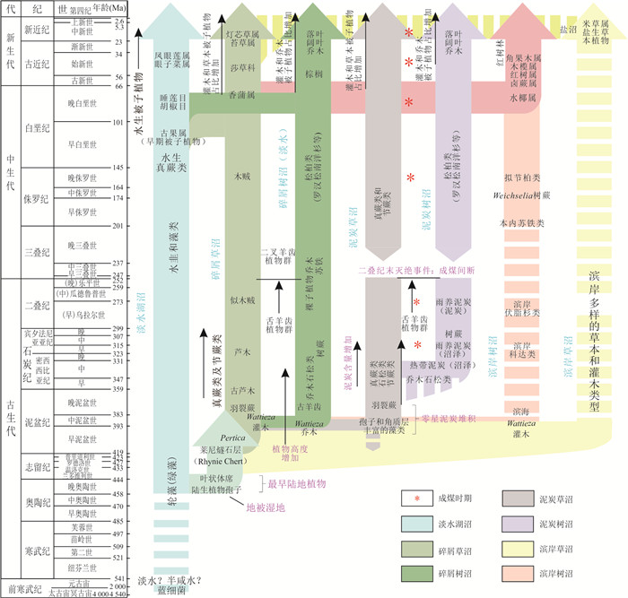
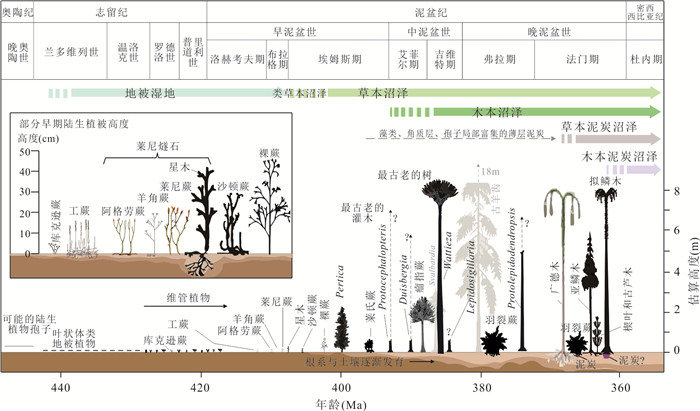
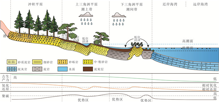
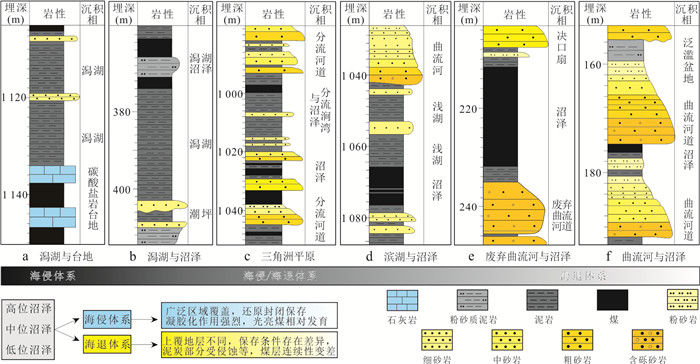
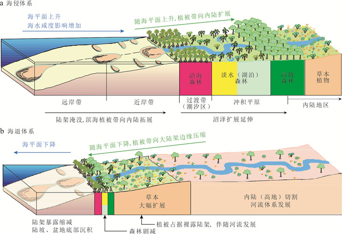
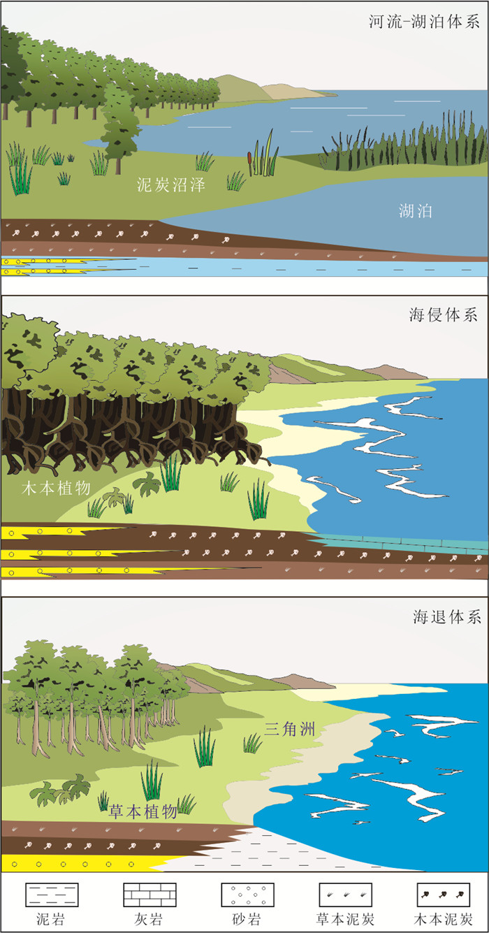
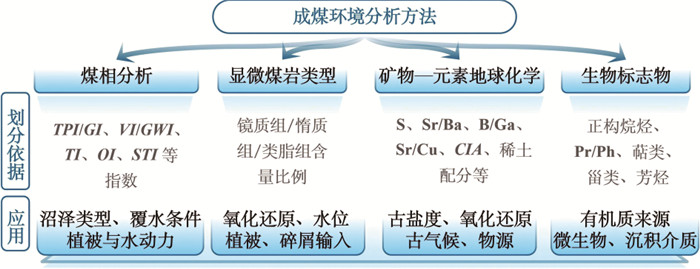
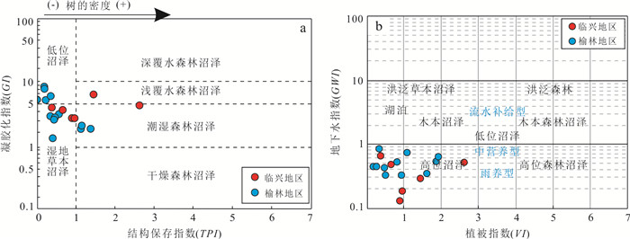
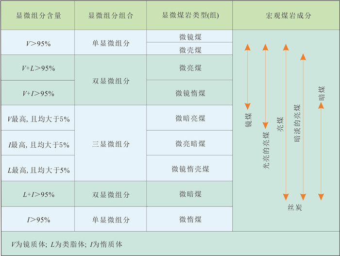
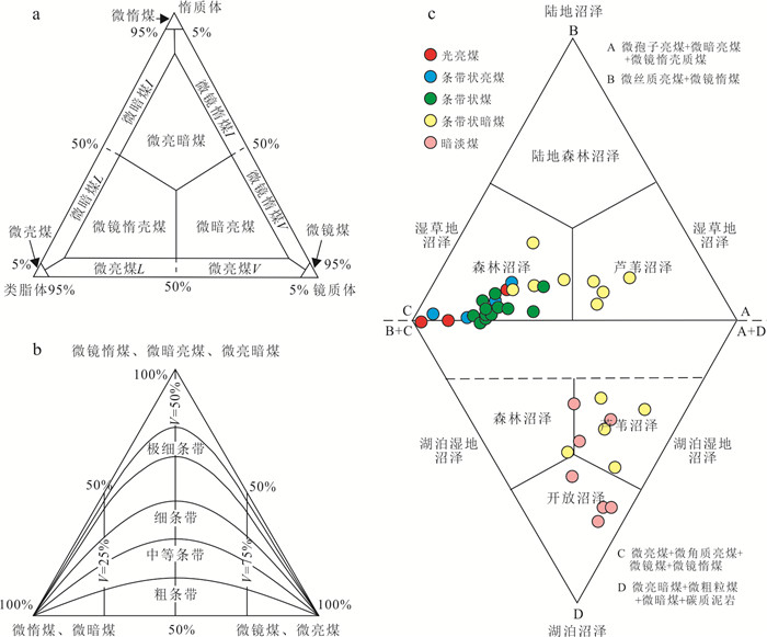
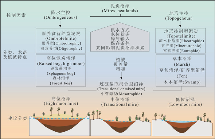
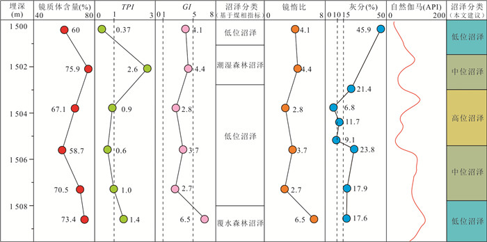
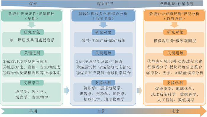
Coal-forming environment analysis is an important basis for understanding coal-measure sedimentary processes, reconstructing paleoenvironmental evolution, and advancing coal geology theory. This paper systematically reviews the evolutionary characteristics of coal-forming environments through geologic time, the distribution and dynamic evolution of peat swamps, and traditional analytical methods for coal-forming environments based on macerals, microlithotypes, mineral-element geochemistry, and biomarkers, and discusses their applicability. The results show that the evolution of coal-forming environments through geologic time was jointly controlled by plant succession, climate change, and adjustments in sedimentary systems, resulting in marked differences in coal-forming plants, peat swamp types, and depositional settings in different periods. Peat swamps are widely developed in delta plains, tidal flat-lagoon systems, fluvial-lacustrine settings, and alluvial plains, and their formation and preservation are jointly constrained by water supply pattern, water-table condition, clastic input, and marine influence. Traditional coal-facies indices play an important role in coal-forming environment analysis, but their environmental significance is readily affected by vegetation composition, decomposition, water-table fluctuations, allochthonous input, and diagenetic-coalification modification. On this basis, it is suggested that coal-forming environment analysis should place greater emphasis on depositional-process constraints and strengthen the integrated identification of key controlling factors such as water supply pattern, water-table condition, clastic input, and preservation conditions. It is further proposed that coal-forming peat swamps can be simplified into three types: low moor mire, transitional mire, and high moor mire. A case study from the Ordos Basin shows that this approach is helpful for revealing the vertical evolutionary pattern of coal-forming environments and can provide a reference for coal-forming environment reconstruction and coal-measure sedimentary research.
Coal-forming environment analysis is an important basis for understanding coal-measure sedimentary processes, reconstructing paleoenvironmental evolution, and advancing coal geology theory. This paper systematically reviews the evolutionary characteristics of coal-forming environments through geologic time, the distribution and dynamic evolution of peat swamps, and traditional analytical methods for coal-forming environments based on macerals, microlithotypes, mineral-element geochemistry, and biomarkers, and discusses their applicability. The results show that the evolution of coal-forming environments through geologic time was jointly controlled by plant succession, climate change, and adjustments in sedimentary systems, resulting in marked differences in coal-forming plants, peat swamp types, and depositional settings in different periods. Peat swamps are widely developed in delta plains, tidal flat-lagoon systems, fluvial-lacustrine settings, and alluvial plains, and their formation and preservation are jointly constrained by water supply pattern, water-table condition, clastic input, and marine influence. Traditional coal-facies indices play an important role in coal-forming environment analysis, but their environmental significance is readily affected by vegetation composition, decomposition, water-table fluctuations, allochthonous input, and diagenetic-coalification modification. On this basis, it is suggested that coal-forming environment analysis should place greater emphasis on depositional-process constraints and strengthen the integrated identification of key controlling factors such as water supply pattern, water-table condition, clastic input, and preservation conditions. It is further proposed that coal-forming peat swamps can be simplified into three types: low moor mire, transitional mire, and high moor mire. A case study from the Ordos Basin shows that this approach is helpful for revealing the vertical evolutionary pattern of coal-forming environments and can provide a reference for coal-forming environment reconstruction and coal-measure sedimentary research.
2026, 51(7): 2499-2513.
doi: 10.3799/dqkx.2026.241
Abstract:
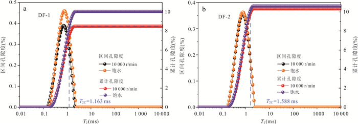
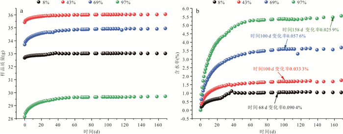
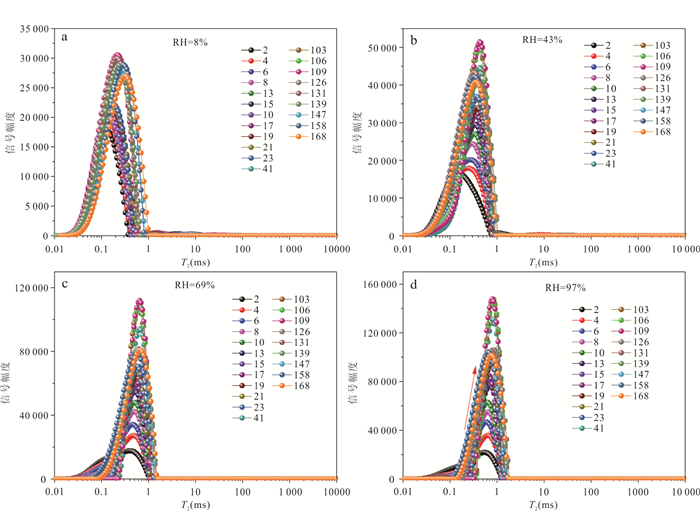
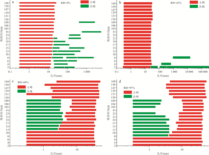
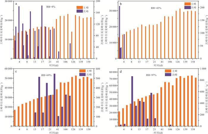
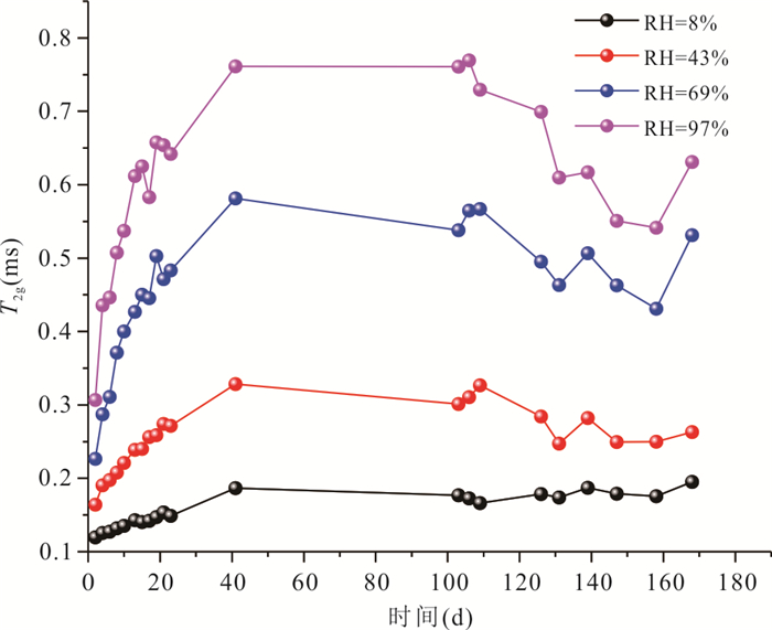
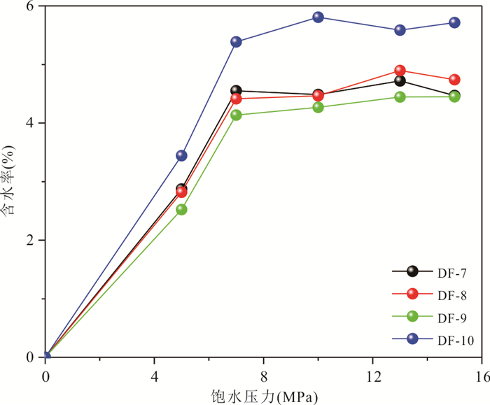
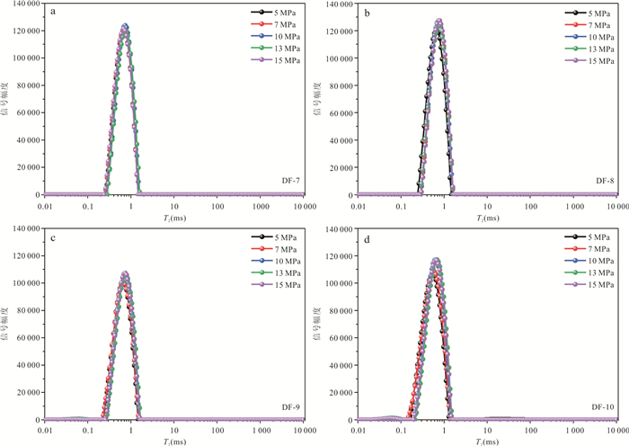
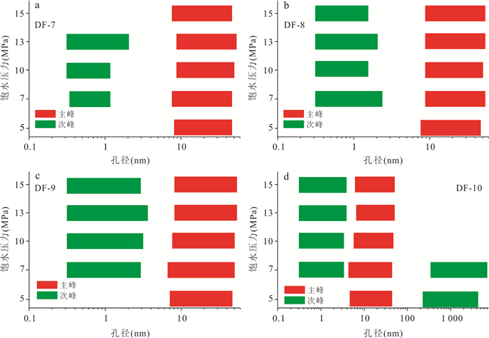
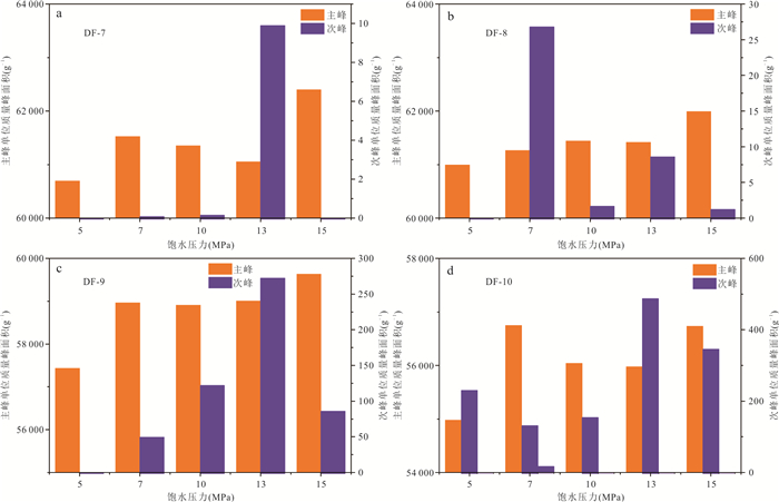
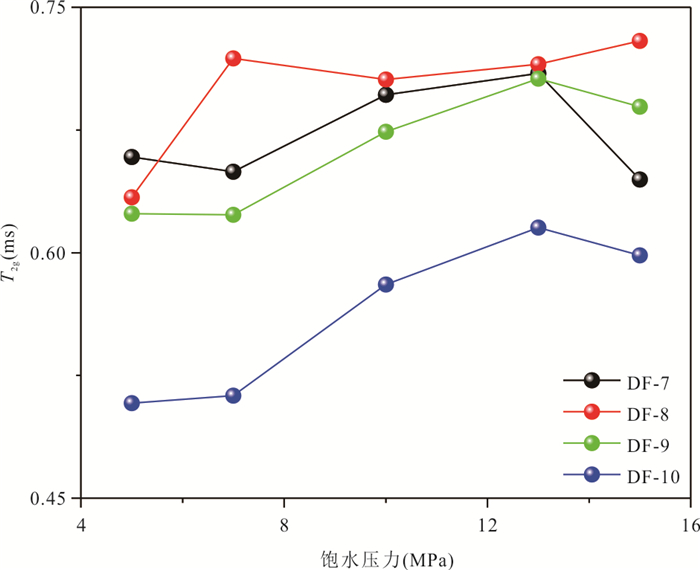
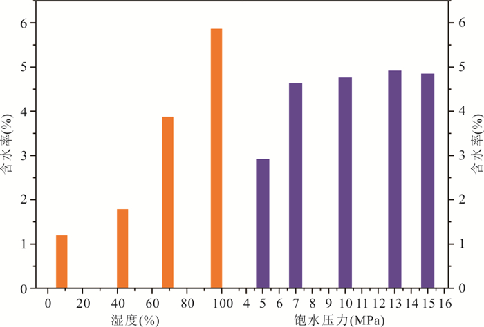
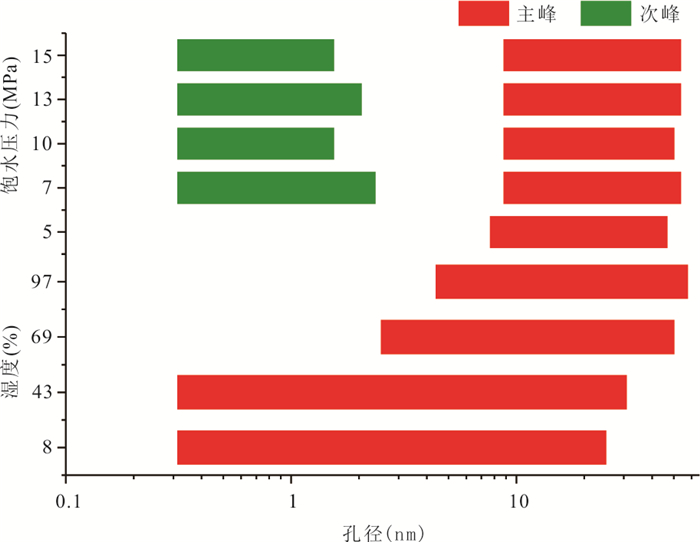
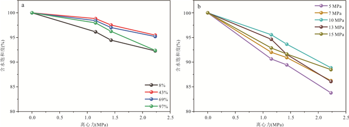
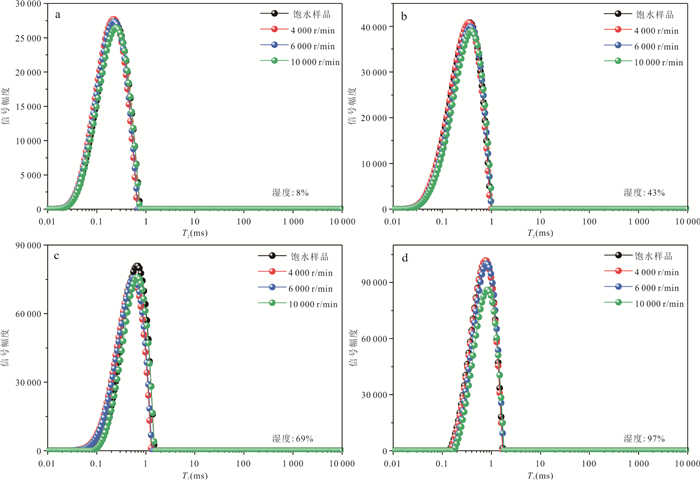
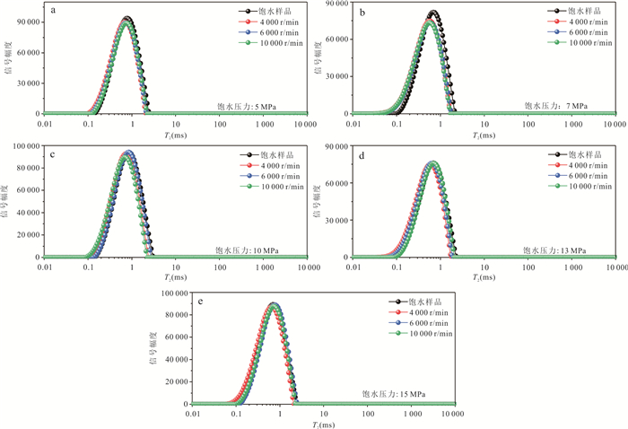
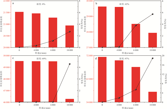
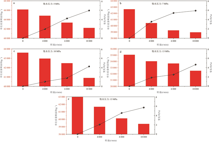
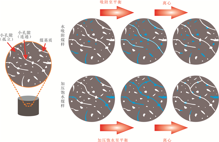
Water occurrence in coal pores is a key factor inducing water-blocking damage and restricting efficient coalbed methane (CBM) production. Current studies mainly focus on the damage caused by artificial fracturing fluid invasion, while the primary adsorbed water formed under the original reservoir humidity environment and its water-blocking effect remain insufficiently understood. Coal samples from the No.3 coal seam of Dongfeng Coal Mine in the Qinshui Basin were selected for this study. Controlled experiments of equilibrium water vapor adsorption (simulating the original reservoir humidity) and pressurized water saturation (simulating fracturing fluid invasion) were carried out. Low-field nuclear magnetic resonance (LF-NMR) was used to characterize the distribution of pore water under the two occurrence conditions, and gradient centrifugation experiments were employed to quantitatively evaluate water mobility. The differences in water occurrence and their control mechanisms on water-blocking damage were systematically compared. The results show that under equilibrium water vapor adsorption, water mainly occurs in micropores and transition pores; higher environmental humidity leads to larger occupied pore sizes and higher water contents at adsorption equilibrium. Under pressurized water saturation, water predominantly occupies transition pores; increasing saturation pressure broadens the range of water-occupied pore sizes, while transforming pore structure and enhancing pore connectivity. Compared with pressurized water-saturated samples, equilibrium water-adsorbed samples have a lower overall water content. However, water vapor can penetrate into micro- and nano-scale pores and even isolated pores, resulting in significantly weaker water mobility and greater difficulty in drainage. The water-blocking damage caused by primary adsorbed water in low-humidity reservoirs is far higher than that caused by high-pressure fracturing fluid invasion. This finding remedies the cognitive deficiency of overemphasizing artificial water injection damage while neglecting primary humidity-related water-blocking. The results can provide microscopic theoretical support for accurate evaluation of water-blocking damage and the optimization of efficient damage removal technologies for coal reservoirs.
Water occurrence in coal pores is a key factor inducing water-blocking damage and restricting efficient coalbed methane (CBM) production. Current studies mainly focus on the damage caused by artificial fracturing fluid invasion, while the primary adsorbed water formed under the original reservoir humidity environment and its water-blocking effect remain insufficiently understood. Coal samples from the No.3 coal seam of Dongfeng Coal Mine in the Qinshui Basin were selected for this study. Controlled experiments of equilibrium water vapor adsorption (simulating the original reservoir humidity) and pressurized water saturation (simulating fracturing fluid invasion) were carried out. Low-field nuclear magnetic resonance (LF-NMR) was used to characterize the distribution of pore water under the two occurrence conditions, and gradient centrifugation experiments were employed to quantitatively evaluate water mobility. The differences in water occurrence and their control mechanisms on water-blocking damage were systematically compared. The results show that under equilibrium water vapor adsorption, water mainly occurs in micropores and transition pores; higher environmental humidity leads to larger occupied pore sizes and higher water contents at adsorption equilibrium. Under pressurized water saturation, water predominantly occupies transition pores; increasing saturation pressure broadens the range of water-occupied pore sizes, while transforming pore structure and enhancing pore connectivity. Compared with pressurized water-saturated samples, equilibrium water-adsorbed samples have a lower overall water content. However, water vapor can penetrate into micro- and nano-scale pores and even isolated pores, resulting in significantly weaker water mobility and greater difficulty in drainage. The water-blocking damage caused by primary adsorbed water in low-humidity reservoirs is far higher than that caused by high-pressure fracturing fluid invasion. This finding remedies the cognitive deficiency of overemphasizing artificial water injection damage while neglecting primary humidity-related water-blocking. The results can provide microscopic theoretical support for accurate evaluation of water-blocking damage and the optimization of efficient damage removal technologies for coal reservoirs.
2026, 51(7): 2514-2527.
doi: 10.3799/dqkx.2026.239
Abstract:
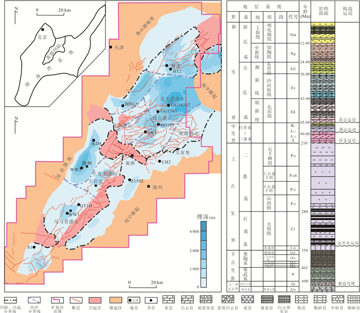
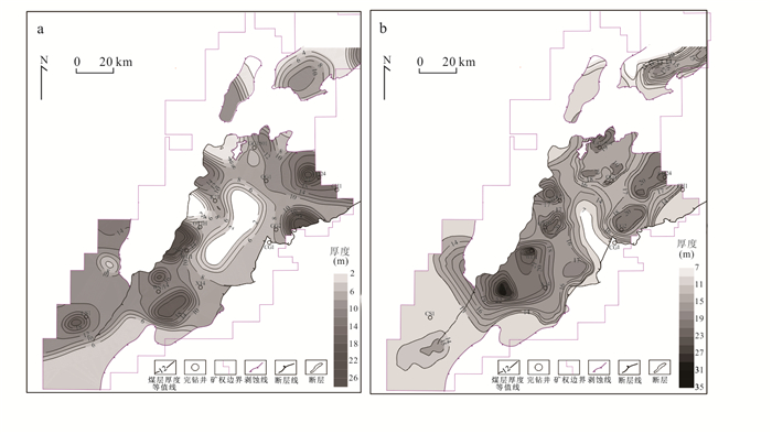
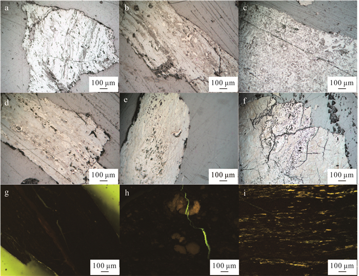
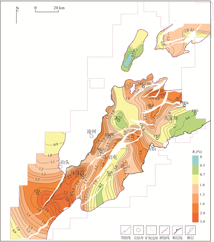
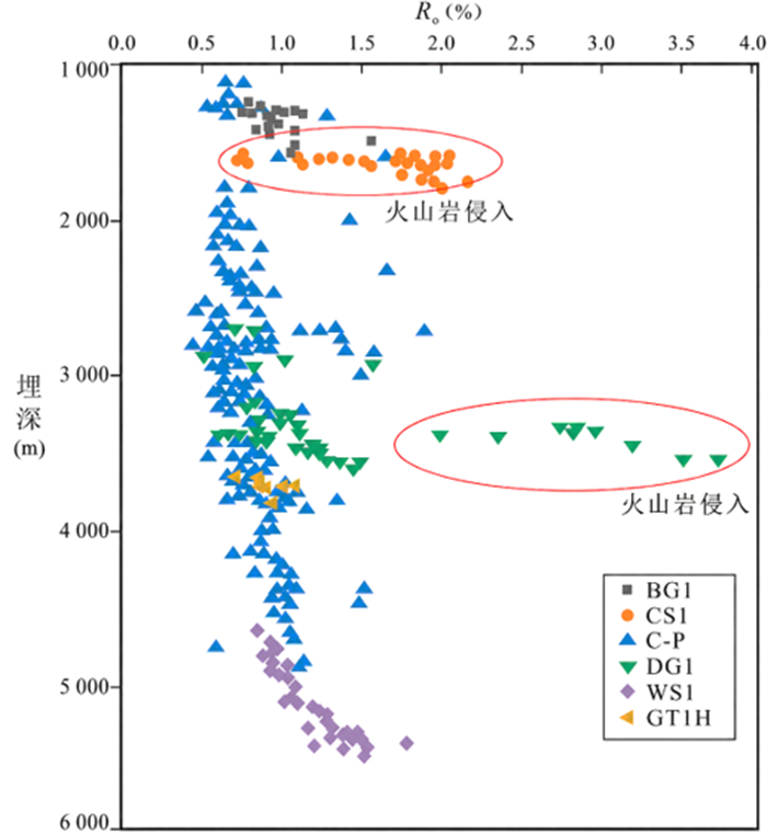
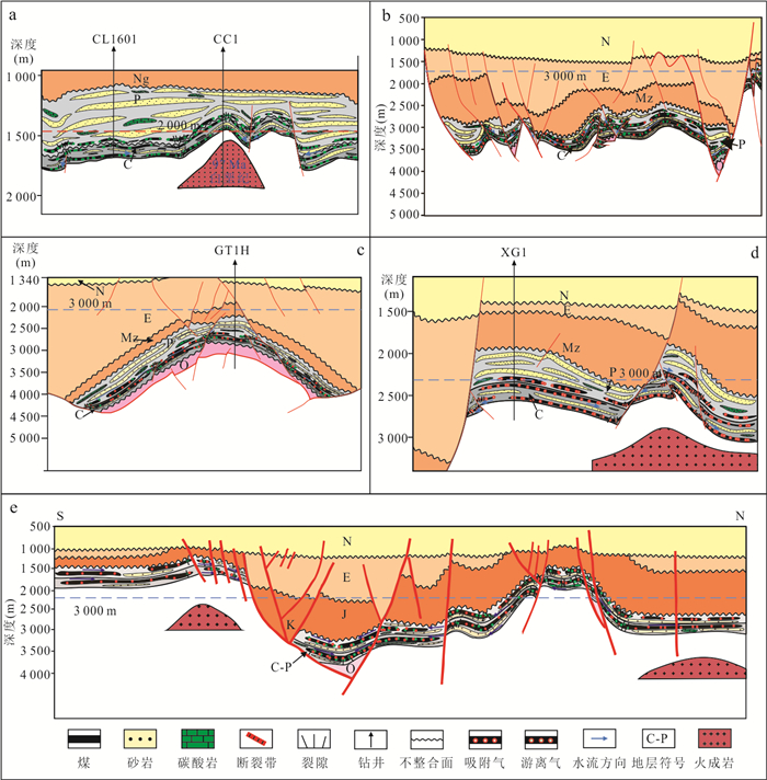
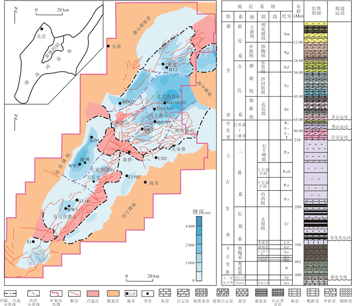
The Huanghua Depression is characterized by complex structural units. The Upper Paleozoic coal seams show marked spatial variations in burial depth, thermal maturity, and preservation conditions, and the enrichment patterns and accumulation types of coalbed methane remain unclear. This study integrated coal-thickness distribution, coal petrographic and coal-quality characteristics, plane distribution of vitrinite reflectance (Ro), burial-thermal evolution histories of typical wells, tectonic evolution, and borehole evidence of magmatic rocks to analyze the controls of sedimentation, tectonic deep burial, and magmatism on coalbed methane accumulation. The coal thickness and lateral continuity of the Taiyuan Formation are generally better than those of the Shanxi Formation, and the Wangguantun-Wumaying and Kongdian-Chenghai areas are the main coal-accumulation zones. Tectonic deep burial resulted in regional high maturity and differentiation of preservation conditions; multi-stage tectonic inversion caused reservoir adjustment; and magmatic thermal events led to abnormally high maturity in shallow-burial areas or structural highs, and could further modify deeply buried coal measures. Coalbed methane enrichment in the study area is jointly controlled by burial heating, tectonic adjustment, and magmatic thermal modification. Four accumulation models are identified: shallow-burial magmatic model, tectonic deep-burial model, multi-stage tectonic inversion model, and deep-burial magmatic model. This study provides a theoretical basis for favorable area selection and exploration potential evaluation of Upper Paleozoic CBM in the Huanghua Depression.
The Huanghua Depression is characterized by complex structural units. The Upper Paleozoic coal seams show marked spatial variations in burial depth, thermal maturity, and preservation conditions, and the enrichment patterns and accumulation types of coalbed methane remain unclear. This study integrated coal-thickness distribution, coal petrographic and coal-quality characteristics, plane distribution of vitrinite reflectance (Ro), burial-thermal evolution histories of typical wells, tectonic evolution, and borehole evidence of magmatic rocks to analyze the controls of sedimentation, tectonic deep burial, and magmatism on coalbed methane accumulation. The coal thickness and lateral continuity of the Taiyuan Formation are generally better than those of the Shanxi Formation, and the Wangguantun-Wumaying and Kongdian-Chenghai areas are the main coal-accumulation zones. Tectonic deep burial resulted in regional high maturity and differentiation of preservation conditions; multi-stage tectonic inversion caused reservoir adjustment; and magmatic thermal events led to abnormally high maturity in shallow-burial areas or structural highs, and could further modify deeply buried coal measures. Coalbed methane enrichment in the study area is jointly controlled by burial heating, tectonic adjustment, and magmatic thermal modification. Four accumulation models are identified: shallow-burial magmatic model, tectonic deep-burial model, multi-stage tectonic inversion model, and deep-burial magmatic model. This study provides a theoretical basis for favorable area selection and exploration potential evaluation of Upper Paleozoic CBM in the Huanghua Depression.
2026, 51(7): 2528-2554.
doi: 10.3799/dqkx.2025.294
Abstract:
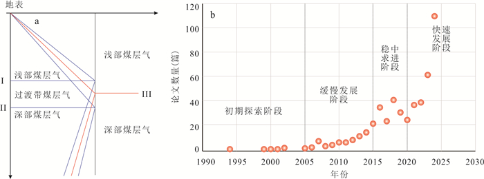
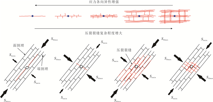
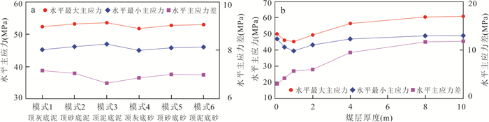
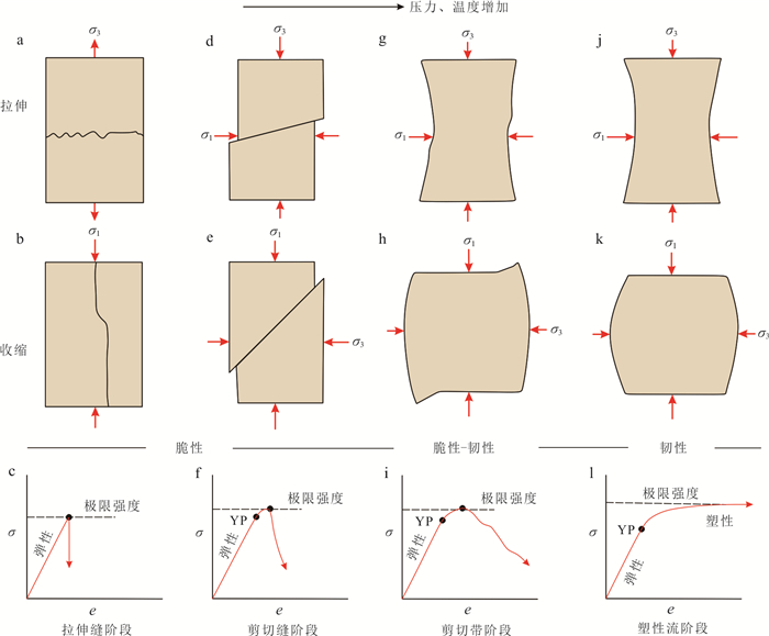
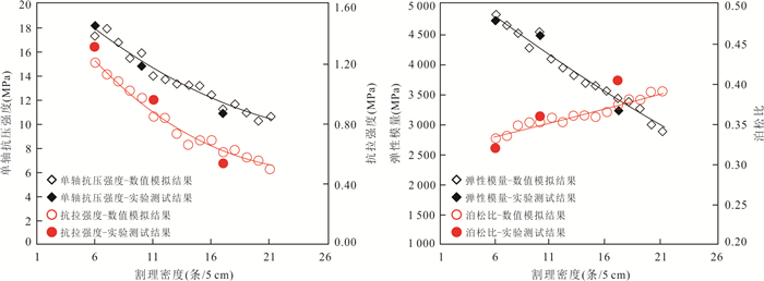
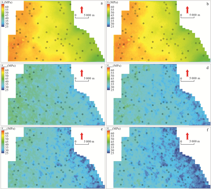
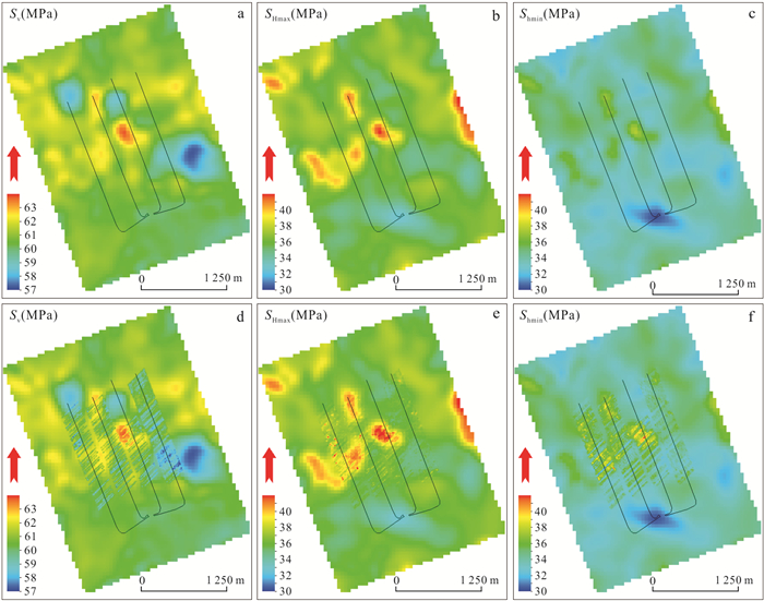
Deep coalbed methane (CBM) resources have great potential and are significant fields for China's future large-scale increase in reserve and production of unconventional natural gas. Reservoir geomechanics plays a vital role in the exploration and development of deep CBM and is the key support for achieving efficient development. In order to find out the current status and progress of geomechanical research within deep CBM reservoirs, in this paper it explored the future development direction based on the analysis of geomechanical characteristics and key technologies of deep CBM reservoirs. The results show follows. (1) The deep geological environment shows characteristics of high geotemperature, high in-situ stress and high fluid pressure, which dominates and controls the changes in the mechanical behavior of coal and rock, and is the key factor in the transition from shallow brittleness to deep brittle-ductile and even ductile. It creates the core research challenges of low porosity/ultralow permeability, strong heterogeneity and anisotropy in the reservoir. Fluid-solid-thermal coupling analysis considering the heterogeneous development characteristics of cleats is an important research content in the geomechanical analysis of deep CBM reservoirs. (2) Fine inversion of in-situ stress field based on multi-data fusion, digital fracture network model construction based on CT/deep learning algorithm, and multi-field coupling numerical simulation are important technical methods for the geomechanical research of deep CBM reservoirs. Intelligent and real-time monitoring technology is the key to reducing costs and increasing efficiency in deep CBM development. (3) Future research should break through the boundaries of traditional single disciplines and focus on developing multi-objective collaborative optimization algorithms that integrate geomechanics, seepage, and economy, building a digital twin system, and realizing the safe, efficient, and economic development of deep CBM.
Deep coalbed methane (CBM) resources have great potential and are significant fields for China's future large-scale increase in reserve and production of unconventional natural gas. Reservoir geomechanics plays a vital role in the exploration and development of deep CBM and is the key support for achieving efficient development. In order to find out the current status and progress of geomechanical research within deep CBM reservoirs, in this paper it explored the future development direction based on the analysis of geomechanical characteristics and key technologies of deep CBM reservoirs. The results show follows. (1) The deep geological environment shows characteristics of high geotemperature, high in-situ stress and high fluid pressure, which dominates and controls the changes in the mechanical behavior of coal and rock, and is the key factor in the transition from shallow brittleness to deep brittle-ductile and even ductile. It creates the core research challenges of low porosity/ultralow permeability, strong heterogeneity and anisotropy in the reservoir. Fluid-solid-thermal coupling analysis considering the heterogeneous development characteristics of cleats is an important research content in the geomechanical analysis of deep CBM reservoirs. (2) Fine inversion of in-situ stress field based on multi-data fusion, digital fracture network model construction based on CT/deep learning algorithm, and multi-field coupling numerical simulation are important technical methods for the geomechanical research of deep CBM reservoirs. Intelligent and real-time monitoring technology is the key to reducing costs and increasing efficiency in deep CBM development. (3) Future research should break through the boundaries of traditional single disciplines and focus on developing multi-objective collaborative optimization algorithms that integrate geomechanics, seepage, and economy, building a digital twin system, and realizing the safe, efficient, and economic development of deep CBM.
2026, 51(7): 2555-2566.
doi: 10.3799/dqkx.2026.240
Abstract:
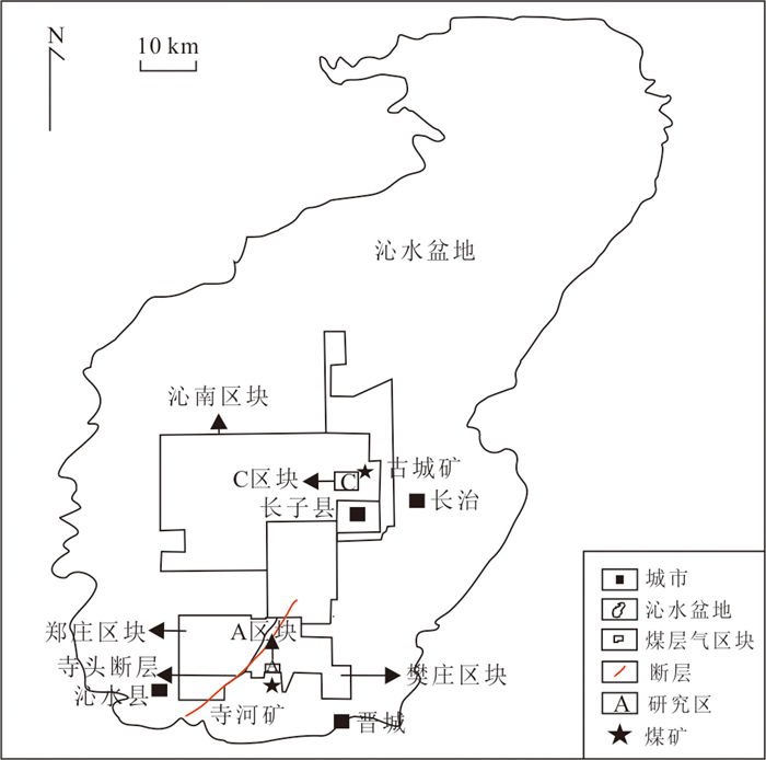
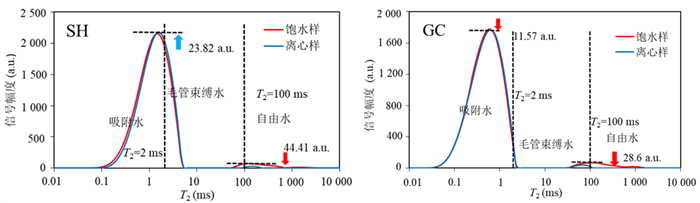
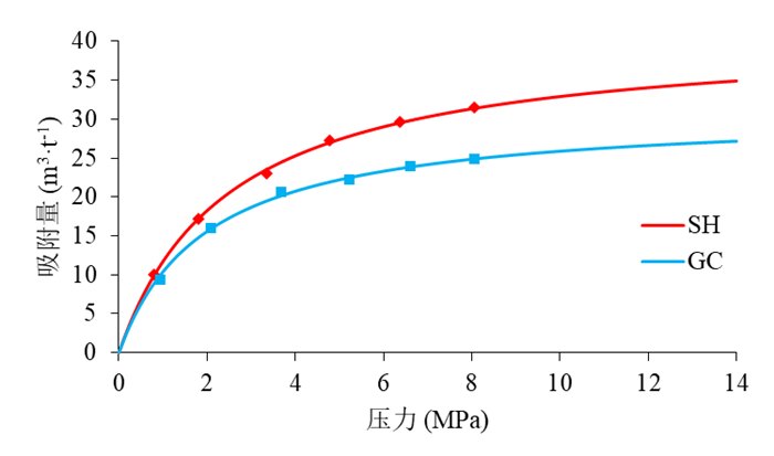
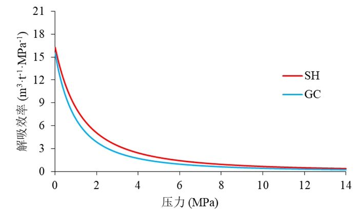
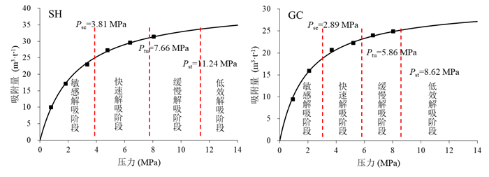
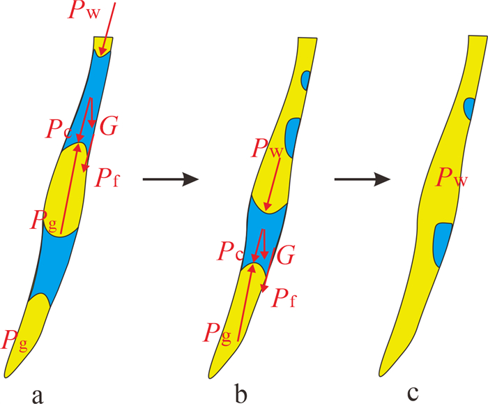
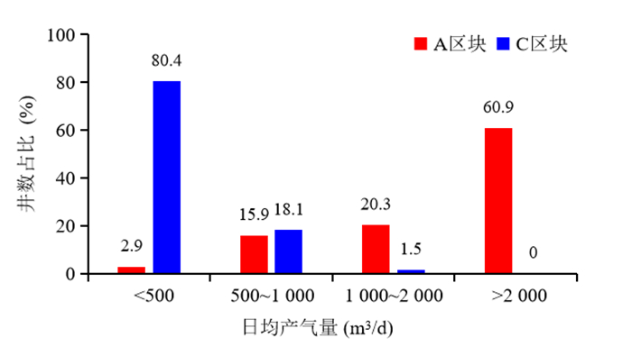
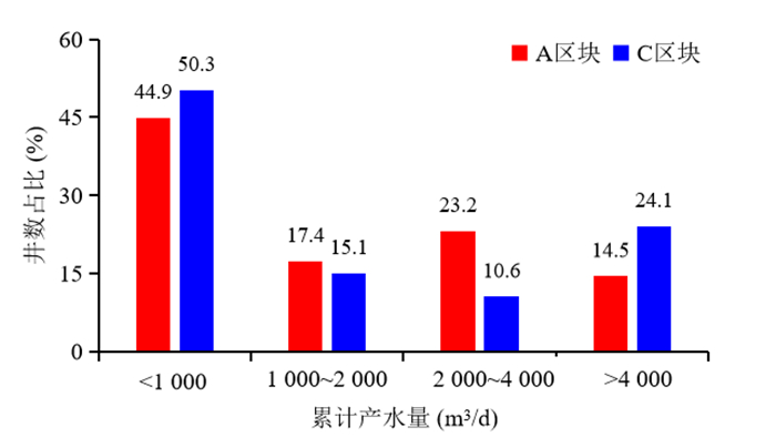
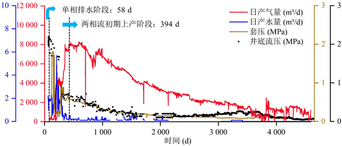
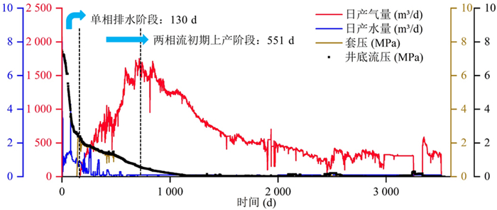
Significant productivity differences exist among high-rank coalbed methane (CBM) wells in the southern Qinshui Basin, and the water-blocking effect is a key microscopic factor limiting CBM desorption and efficient production. To reveal the pore-water occurrence law, water-blocking effect, and the control on CBM production in high-rank coal, the southern Fanzhuang Block (Block A) and eastern Qinnan Block (Block C) were selected, and the No.3 coal samples were collected from Sihe Coal Mine (SH, anthracite) and Gucheng Coal Mine (GC, lean coal). Low-field nuclear magnetic resonance (NMR) pore-fluid test and high-pressure methane isothermal adsorption experiment were conducted. Combined with long-term production data from CBM wells, the differences in pore-water occurrence and water-phase distribution in coal pores were systematically analyzed, and the coupling response mechanism of pore-water occurrence, water-blocking effect, and CBM desorption-production was clarified. SH coal is dominated by water in transition pores (10-100 nm) with a proportion of 55.97%, while micropores (<10 nm) account for 40.87%. In contrast, GC coal has a micropore water proportion of 81.72% and a transition pore proportion of 14.51%. After centrifugation at 1.61 MPa, the adsorbed water proportion of SH coal is 73.89%, significantly lower than 97.94% of GC coal, indicating that Block C has well-developed micropores, a high volume of adsorbed water, and strong capillary binding forces, making the risk of damage from water-blocking effect significantly higher than that in Block A. Under reservoir pressure, the average methane desorption rate of Block A reaches 5.27 m3·t-1·MPa-1, far exceeding 1.45 m3·t-1·MPa-1 of Block C, demonstrating stronger desorption driving force and lower fluid migration resistance. Production data confirm that Block C exhibits a longer single-phase water drainage period, greater difficulty in pressure reduction and desorption, limited pressure-drop funnel expansion during the two-phase flow stage, and slow productivity improvement. Both the cumulative gas production and the peak daily gas production capacity in Block A are significantly higher than those in Block C. This paper analyzes the effect of the microscopic pore-water occurrence on macroscopic CBM production performance of high-rank coal. It is clarified that enriched adsorbed water in micropores induces high-intensity water blocking and restricts efficient gas-water migration, which is the core cause of block productivity differentiation. The results provide theoretical support for productivity evaluation, water-blocking damage prevention, and production parameter optimization of high-rank coal reservoirs.
Significant productivity differences exist among high-rank coalbed methane (CBM) wells in the southern Qinshui Basin, and the water-blocking effect is a key microscopic factor limiting CBM desorption and efficient production. To reveal the pore-water occurrence law, water-blocking effect, and the control on CBM production in high-rank coal, the southern Fanzhuang Block (Block A) and eastern Qinnan Block (Block C) were selected, and the No.3 coal samples were collected from Sihe Coal Mine (SH, anthracite) and Gucheng Coal Mine (GC, lean coal). Low-field nuclear magnetic resonance (NMR) pore-fluid test and high-pressure methane isothermal adsorption experiment were conducted. Combined with long-term production data from CBM wells, the differences in pore-water occurrence and water-phase distribution in coal pores were systematically analyzed, and the coupling response mechanism of pore-water occurrence, water-blocking effect, and CBM desorption-production was clarified. SH coal is dominated by water in transition pores (10-100 nm) with a proportion of 55.97%, while micropores (<10 nm) account for 40.87%. In contrast, GC coal has a micropore water proportion of 81.72% and a transition pore proportion of 14.51%. After centrifugation at 1.61 MPa, the adsorbed water proportion of SH coal is 73.89%, significantly lower than 97.94% of GC coal, indicating that Block C has well-developed micropores, a high volume of adsorbed water, and strong capillary binding forces, making the risk of damage from water-blocking effect significantly higher than that in Block A. Under reservoir pressure, the average methane desorption rate of Block A reaches 5.27 m3·t-1·MPa-1, far exceeding 1.45 m3·t-1·MPa-1 of Block C, demonstrating stronger desorption driving force and lower fluid migration resistance. Production data confirm that Block C exhibits a longer single-phase water drainage period, greater difficulty in pressure reduction and desorption, limited pressure-drop funnel expansion during the two-phase flow stage, and slow productivity improvement. Both the cumulative gas production and the peak daily gas production capacity in Block A are significantly higher than those in Block C. This paper analyzes the effect of the microscopic pore-water occurrence on macroscopic CBM production performance of high-rank coal. It is clarified that enriched adsorbed water in micropores induces high-intensity water blocking and restricts efficient gas-water migration, which is the core cause of block productivity differentiation. The results provide theoretical support for productivity evaluation, water-blocking damage prevention, and production parameter optimization of high-rank coal reservoirs.
2026, 51(7): 2567-2581.
doi: 10.3799/dqkx.2025.254
Abstract:
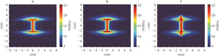
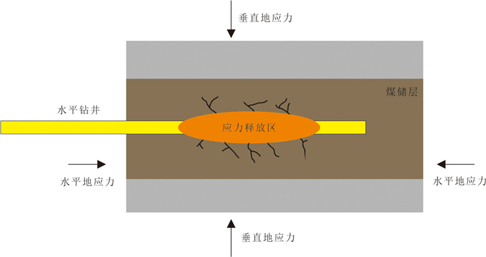
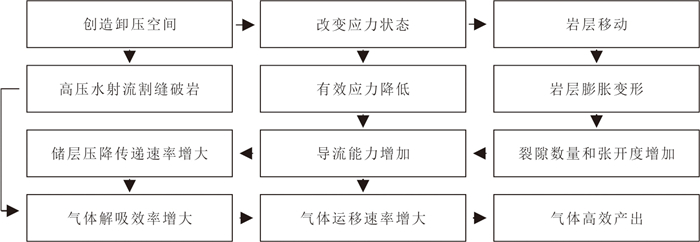
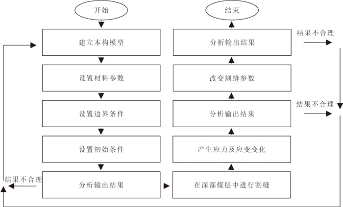
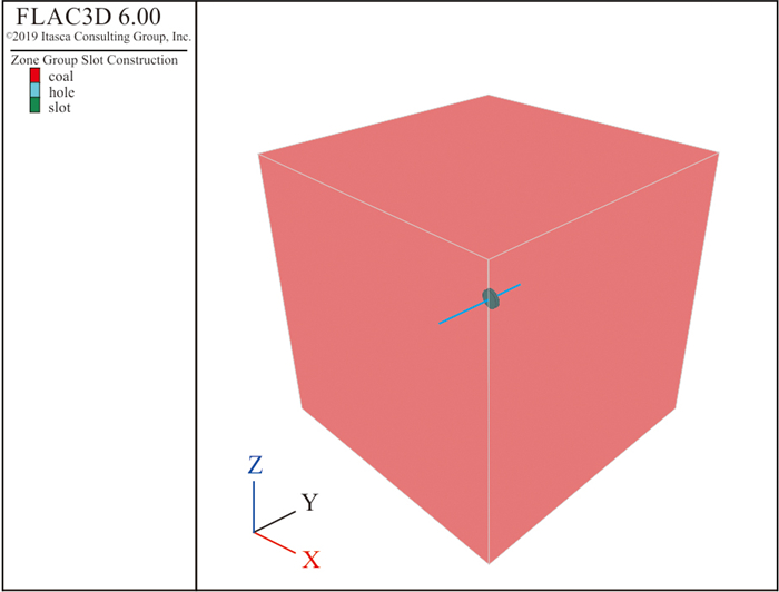
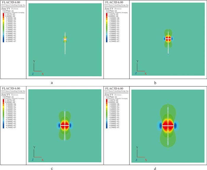
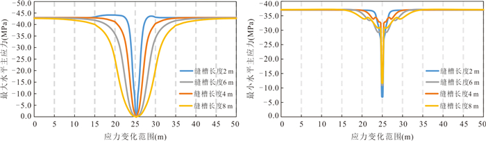
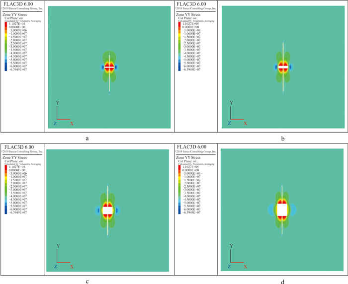
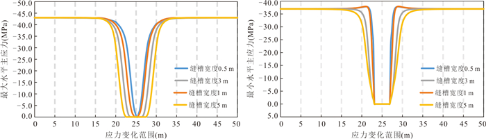
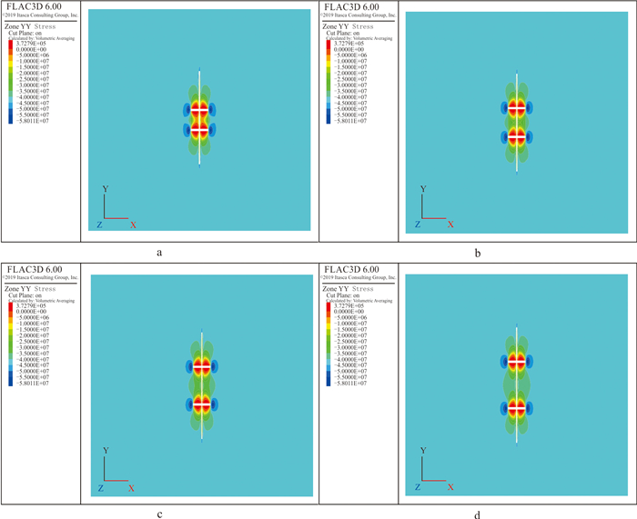
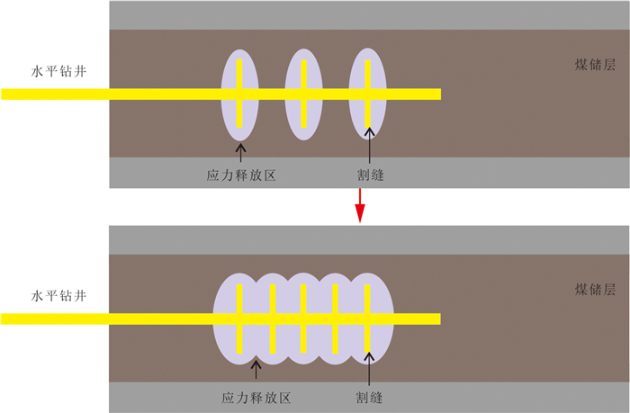
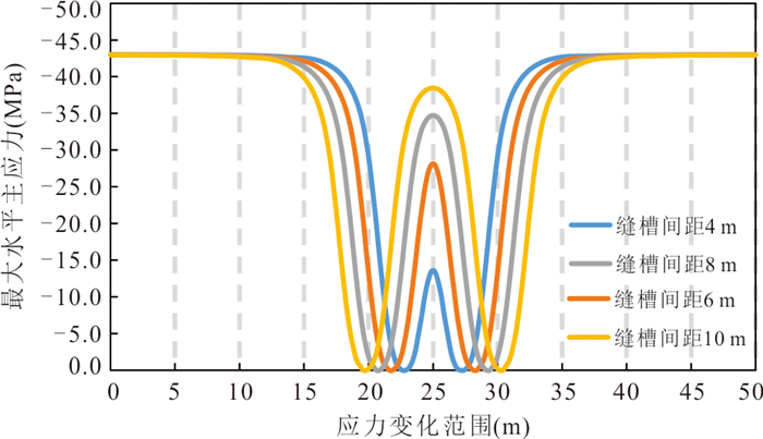
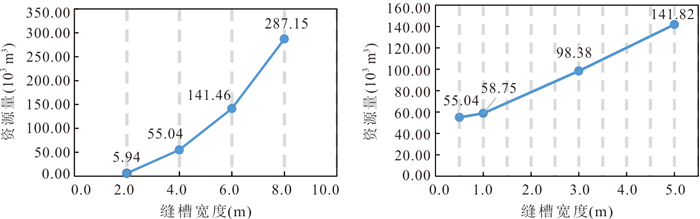
To improve the efficiency of deep coal rock gas development, this study takes the Daning-Jixian Block in the eastern margin of the Ordos Basin as the research object. Using Flac3D numerical simulation and theoretical analysis methods, the in-situ stress response under hydraulic slotting in deep coal rock gas reservoirs was investigated. The results show that the stress relief space created by hydraulic slotting in coal rock gas reservoirs can effectively alter the in-situ stress state, reduce reservoir effective stress, and enhance reservoir conductivity. For every 1 m increase in slot length, the stress relief range expands by 4.3-4.9 m, and the degree of stress relief increases by 4.7%-21%. For every 1 m increase in slot width, the stress relief range increases by 0.3-0.7 m, while the degree of stress relief decreases by 0.7%-1.4%. Compared with a single slot, multiple sets of slots can form superimposed stress release zones, further expanding the stress relief range and enhancing the stress relief effect. Optimizing slot length and spacing can significantly increase the controlled range of coal rock gas recovery resources. Hydraulic slotting in coal rock gas reservoirs has a significant effect on in-situ stress modification. This research can provide a basis for the efficient development of coal rock gas through hydraulic slotting technology.
To improve the efficiency of deep coal rock gas development, this study takes the Daning-Jixian Block in the eastern margin of the Ordos Basin as the research object. Using Flac3D numerical simulation and theoretical analysis methods, the in-situ stress response under hydraulic slotting in deep coal rock gas reservoirs was investigated. The results show that the stress relief space created by hydraulic slotting in coal rock gas reservoirs can effectively alter the in-situ stress state, reduce reservoir effective stress, and enhance reservoir conductivity. For every 1 m increase in slot length, the stress relief range expands by 4.3-4.9 m, and the degree of stress relief increases by 4.7%-21%. For every 1 m increase in slot width, the stress relief range increases by 0.3-0.7 m, while the degree of stress relief decreases by 0.7%-1.4%. Compared with a single slot, multiple sets of slots can form superimposed stress release zones, further expanding the stress relief range and enhancing the stress relief effect. Optimizing slot length and spacing can significantly increase the controlled range of coal rock gas recovery resources. Hydraulic slotting in coal rock gas reservoirs has a significant effect on in-situ stress modification. This research can provide a basis for the efficient development of coal rock gas through hydraulic slotting technology.
2026, 51(7): 2582-2595.
doi: 10.3799/dqkx.2025.217
Abstract:
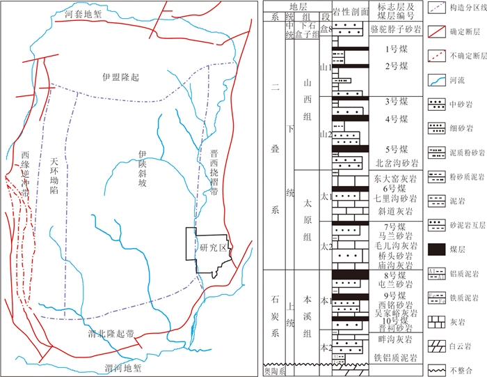
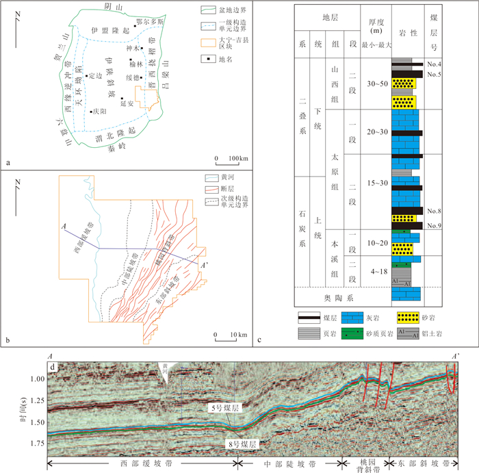
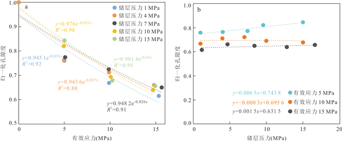
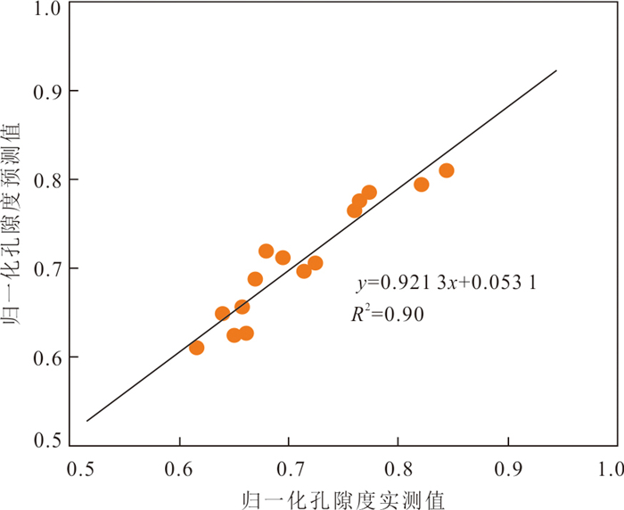
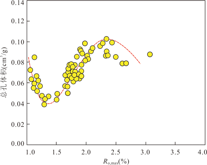
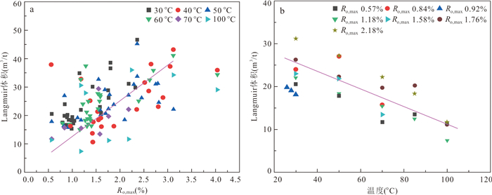
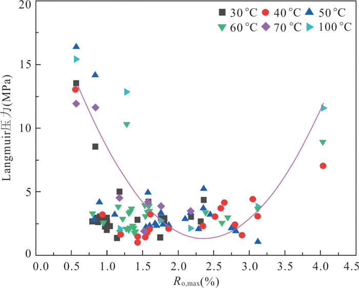
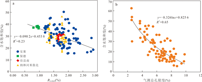
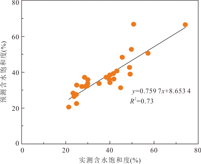
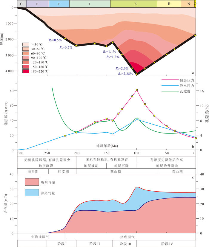
The occurrence state of coalbed methane (CBM) is one of the key factors influencing the resource assessment and the development efficiency of deep CBM. In order to elucidate the dynamic evolution laws of free gas and adsorbed gas within deep coal reservoirs, as well as their geological controls, thereby deepening the understanding of deep CBM accumulation processes, this study focuses on the No. 8 coal seam of the Taiyuan Formation in the Daning-Jixian Block, Ordos Basin.Prediction models for free gas content, adsorbed gas content, in-situ porosity, and water saturation were established. These were integrated with a systematic reconstruction of the coal seam burial history, thermal history, thermal maturation, and reservoir pressure evolution, to investigate the dynamic evolution of gas occurrence states during CBM accumulation.The results indicate that the dynamic evolution of free and adsorbed gas during CBM accumulation in the study area can be classified into four stages: (Ⅰ) Late Permian-Early Jurassic: a period of rapid coal seam subsidence, accompanied by a sustained rise in adsorbed gas content and negligible free gas occurrence; (Ⅱ) Early Jurassic-Early Cretaceous: a stage of minor fluctuations in burial depth of coal seam, during which free gas content gradually increased, while adsorbed gas content exhibited oscillatory variations; (Ⅲ) Early Cretaceous-Middle Cretaceous: second rapid subsidence phase of coal seam, in which free gas content first decreases and then increases, with adsorbed gas content rising slowly; (Ⅳ) Middle Cretaceous-present: rapid uplift of coal seams, during which free gas content gradually decreases, while adsorbed gas content continues to increase.The findings of this study can provide a theoretical reference for favorable zone selection and efficient exploitation of deep CBM resources.
The occurrence state of coalbed methane (CBM) is one of the key factors influencing the resource assessment and the development efficiency of deep CBM. In order to elucidate the dynamic evolution laws of free gas and adsorbed gas within deep coal reservoirs, as well as their geological controls, thereby deepening the understanding of deep CBM accumulation processes, this study focuses on the No. 8 coal seam of the Taiyuan Formation in the Daning-Jixian Block, Ordos Basin.Prediction models for free gas content, adsorbed gas content, in-situ porosity, and water saturation were established. These were integrated with a systematic reconstruction of the coal seam burial history, thermal history, thermal maturation, and reservoir pressure evolution, to investigate the dynamic evolution of gas occurrence states during CBM accumulation.The results indicate that the dynamic evolution of free and adsorbed gas during CBM accumulation in the study area can be classified into four stages: (Ⅰ) Late Permian-Early Jurassic: a period of rapid coal seam subsidence, accompanied by a sustained rise in adsorbed gas content and negligible free gas occurrence; (Ⅱ) Early Jurassic-Early Cretaceous: a stage of minor fluctuations in burial depth of coal seam, during which free gas content gradually increased, while adsorbed gas content exhibited oscillatory variations; (Ⅲ) Early Cretaceous-Middle Cretaceous: second rapid subsidence phase of coal seam, in which free gas content first decreases and then increases, with adsorbed gas content rising slowly; (Ⅳ) Middle Cretaceous-present: rapid uplift of coal seams, during which free gas content gradually decreases, while adsorbed gas content continues to increase.The findings of this study can provide a theoretical reference for favorable zone selection and efficient exploitation of deep CBM resources.

2026, 51(7): 2596-2611.
doi: 10.3799/dqkx.2025.213
Abstract:
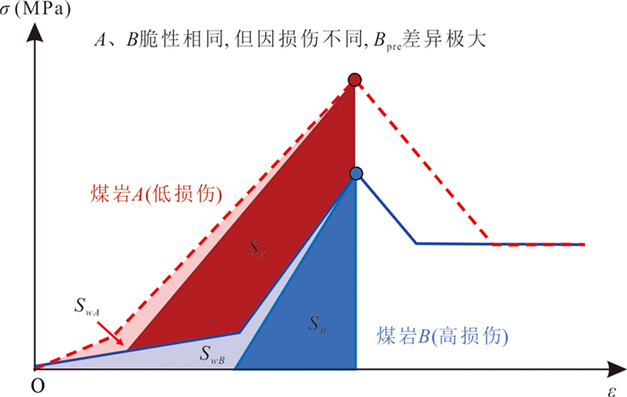
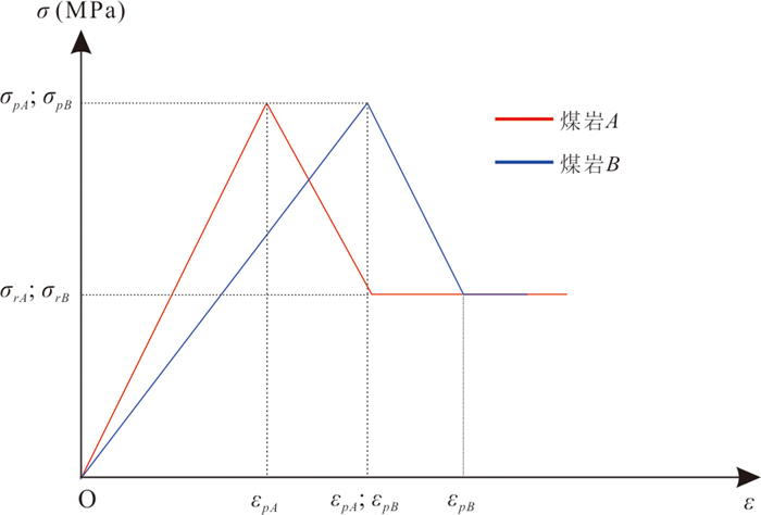
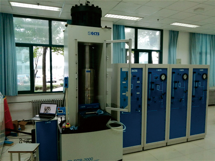
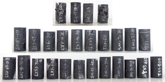
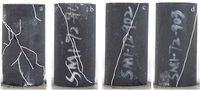
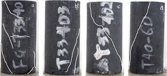
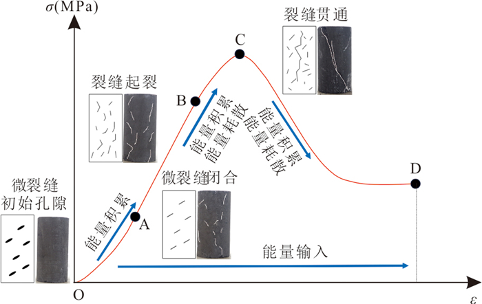
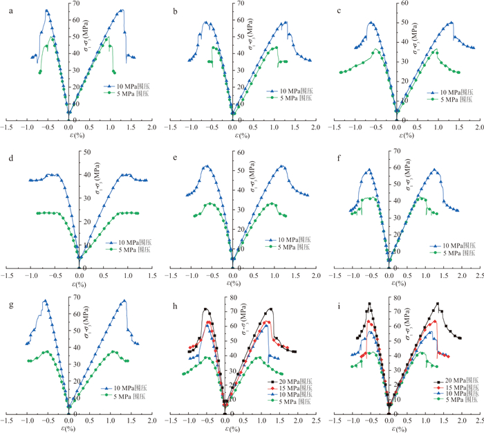
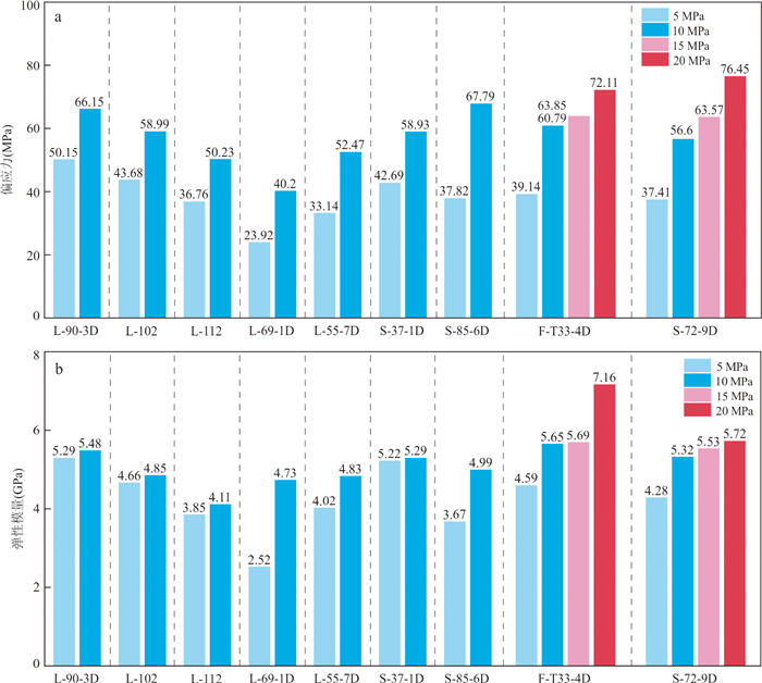
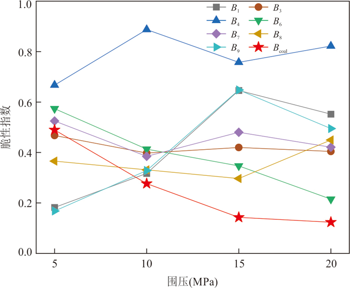
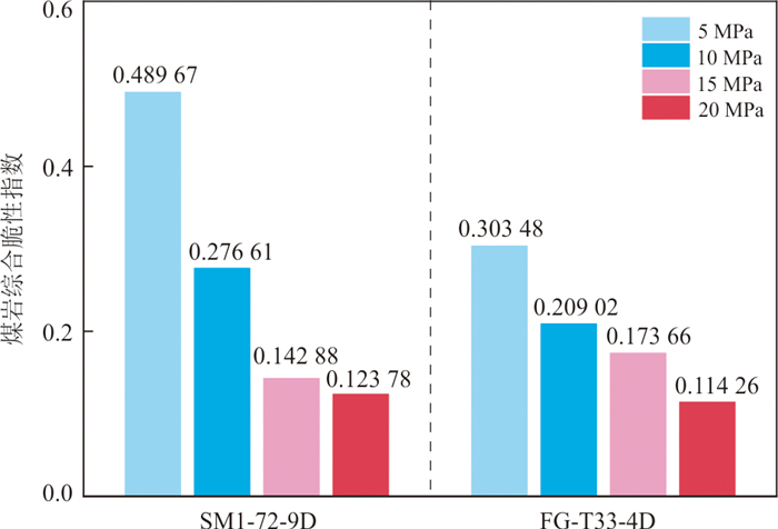
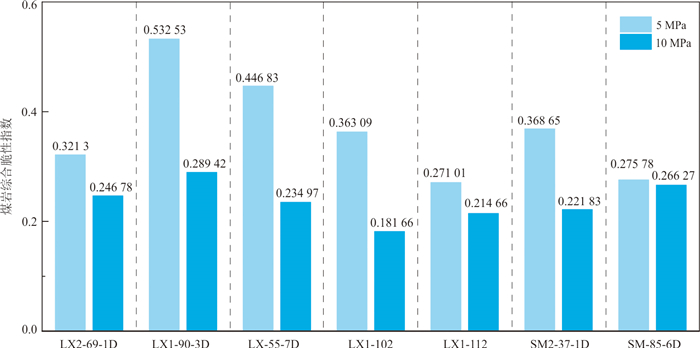
The accuracy of brittleness evaluation critically influences the effectiveness of hydraulic fracturing in deep coal reservoirs; however, conventional methods, largely developed for shale, are inadequate for coal rocks owing to their complex cleat systems and pronounced sensitivity to confining pressure. To address this, triaxial compression tests were conducted to obtain the stress-strain curves of coal rocks. A damage variable was introduced to quantify the nonlinear impact of pre-peak crack evolution on energy distribution, formulating a dual-parameter pre-peak brittleness index, Bpre, based on damage and energy. Incorporating the dynamic constraint effect of confining pressure, a post-peak brittleness index, Bpost, was established by coupling the stress drop rate with confining pressure. Subsequently, a comprehensive coal brittleness index, Bcoal, was derived by employing the harmonic mean method, integrating both pre- and post-peak energy characteristics and confining pressure constraints. Experimental results demonstrate that Bcoal effectively differentiates the brittleness of coal rocks across varying confining pressures, demonstrating reliable evaluation within the confining pressure range of 5 to 20 MPa, and exhibiting superior sensitivity and reliability over traditional methods. This study enhances the accuracy of coal brittleness evaluation, thereby providing crucial theoretical support for the optimization of coalbed methane fracturing strategies.
The accuracy of brittleness evaluation critically influences the effectiveness of hydraulic fracturing in deep coal reservoirs; however, conventional methods, largely developed for shale, are inadequate for coal rocks owing to their complex cleat systems and pronounced sensitivity to confining pressure. To address this, triaxial compression tests were conducted to obtain the stress-strain curves of coal rocks. A damage variable was introduced to quantify the nonlinear impact of pre-peak crack evolution on energy distribution, formulating a dual-parameter pre-peak brittleness index, Bpre, based on damage and energy. Incorporating the dynamic constraint effect of confining pressure, a post-peak brittleness index, Bpost, was established by coupling the stress drop rate with confining pressure. Subsequently, a comprehensive coal brittleness index, Bcoal, was derived by employing the harmonic mean method, integrating both pre- and post-peak energy characteristics and confining pressure constraints. Experimental results demonstrate that Bcoal effectively differentiates the brittleness of coal rocks across varying confining pressures, demonstrating reliable evaluation within the confining pressure range of 5 to 20 MPa, and exhibiting superior sensitivity and reliability over traditional methods. This study enhances the accuracy of coal brittleness evaluation, thereby providing crucial theoretical support for the optimization of coalbed methane fracturing strategies.
2026, 51(7): 2612-2625.
doi: 10.3799/dqkx.2026.132
Abstract:
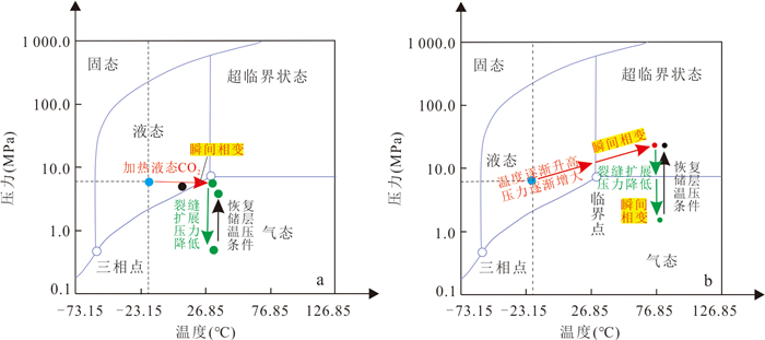
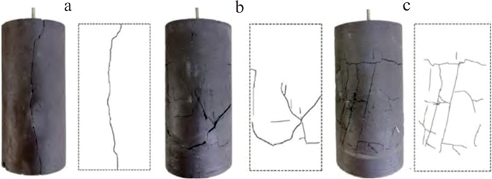
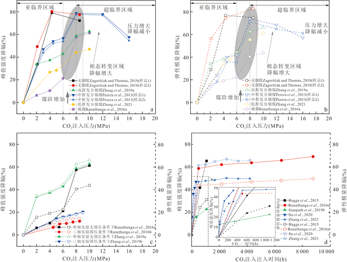
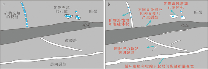
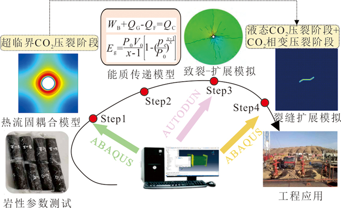
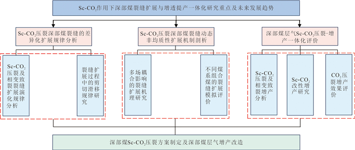
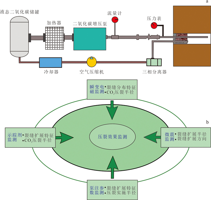
Supercritical CO2 (Sc-CO2) fracturing in deep coal reservoirs offers dual benefits of enhanced permeability and carbon sequestration. This study integrates experimental analysis, theoretical modeling, and numerical simulation to investigate the mechanical response mechanisms of fracture initiation and propagation in deep coal reservoirs during Sc-CO2 fracturing, elucidate the mechanisms of production enhancement, and propose integrated research directions of fracture propagation and increased permeability and production. The results show that the fracture initiation and propagation of Sc-CO2 fracturing in deep coal reservoirs are jointly influenced by reservoir characteristics and CO2 injection parameters, with the mechanical response constrained by mechanisms including surface energy reduction, plasticization, expansion, and mineral dissolution. A staged model of thermo-hydro-mechanical coupling-energy and mass transfer can characterize the fracture propagation and production enhancement effects across stages (Sc-CO2 fracturing, phase-change fracturing, and modification). Sc-CO2 achieves production enhancement through methane displacement, mechanical weakening, and permeability increase. Future research should focus on the differential fracture propagation laws, the dynamic heterogeneous fracture propagation mechanisms, and the integrated evaluation for fracturing and production enhancement during Sc-CO2 fracturing in deep coal reservoirs. This research provides technical support for the Sc-CO2 fracturing design in deep coal reservoirs and coalbed methane production enhancement projects.
Supercritical CO2 (Sc-CO2) fracturing in deep coal reservoirs offers dual benefits of enhanced permeability and carbon sequestration. This study integrates experimental analysis, theoretical modeling, and numerical simulation to investigate the mechanical response mechanisms of fracture initiation and propagation in deep coal reservoirs during Sc-CO2 fracturing, elucidate the mechanisms of production enhancement, and propose integrated research directions of fracture propagation and increased permeability and production. The results show that the fracture initiation and propagation of Sc-CO2 fracturing in deep coal reservoirs are jointly influenced by reservoir characteristics and CO2 injection parameters, with the mechanical response constrained by mechanisms including surface energy reduction, plasticization, expansion, and mineral dissolution. A staged model of thermo-hydro-mechanical coupling-energy and mass transfer can characterize the fracture propagation and production enhancement effects across stages (Sc-CO2 fracturing, phase-change fracturing, and modification). Sc-CO2 achieves production enhancement through methane displacement, mechanical weakening, and permeability increase. Future research should focus on the differential fracture propagation laws, the dynamic heterogeneous fracture propagation mechanisms, and the integrated evaluation for fracturing and production enhancement during Sc-CO2 fracturing in deep coal reservoirs. This research provides technical support for the Sc-CO2 fracturing design in deep coal reservoirs and coalbed methane production enhancement projects.
2026, 51(7): 2626-2645.
doi: 10.3799/dqkx.2026.029
Abstract:
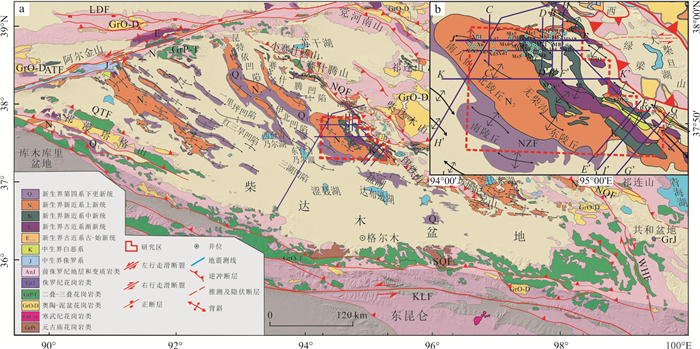
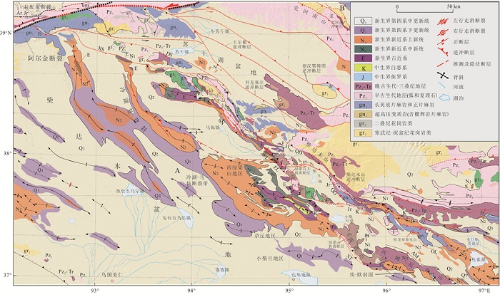
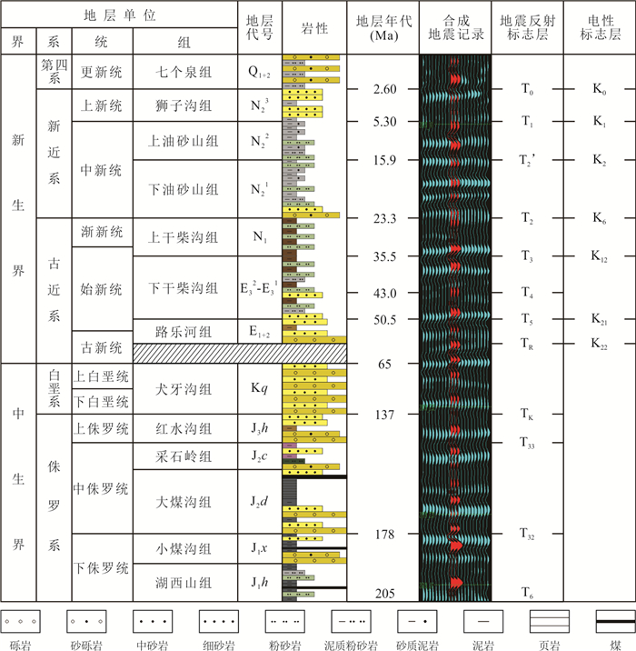
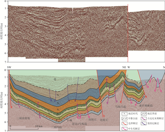
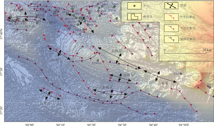
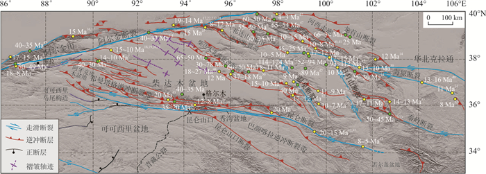
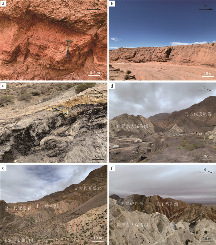
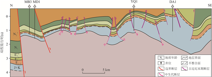
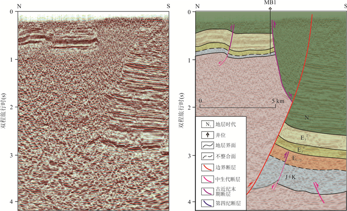
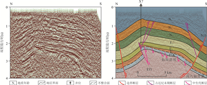
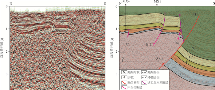
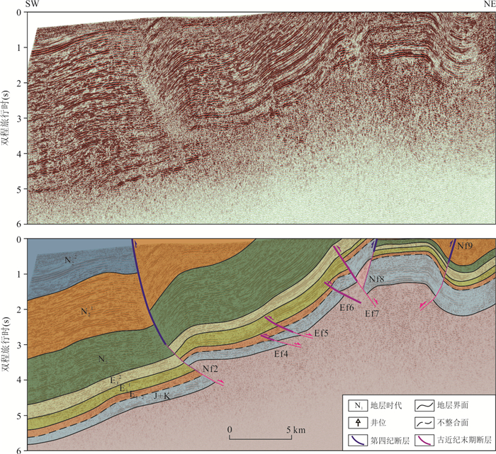
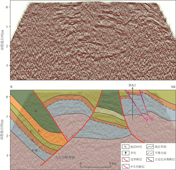
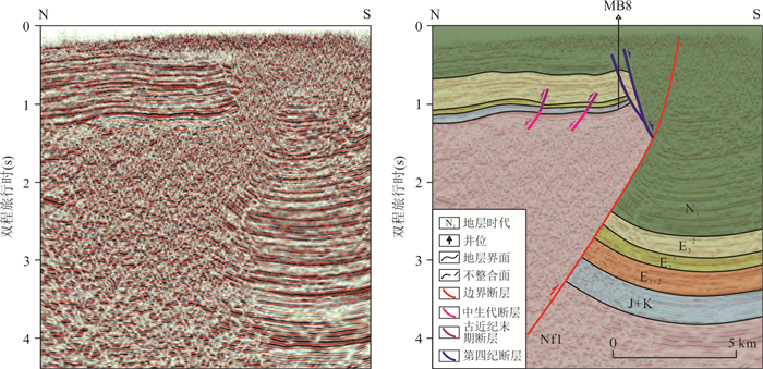
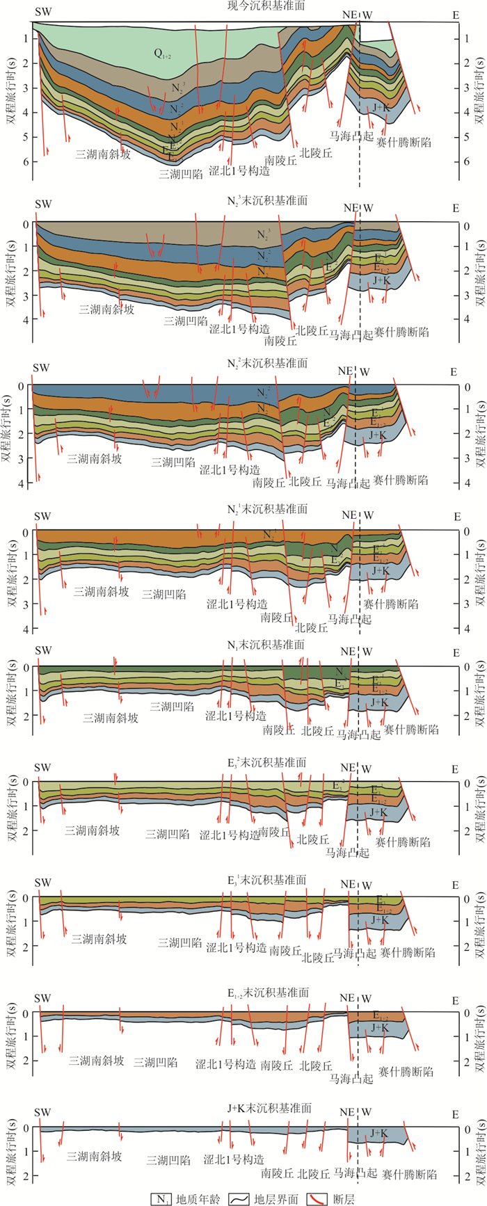
The northern margin of the Qaidam Basin (NQB) preserves key records of the Mesozoic-Cenozoic tectonic evolution of the northeastern Tibetan Plateau. However, significant controversies remain regarding the nature of the Mesozoic basin (extensional vs. compressional) and the tectonic setting during the Paleogene.To address these issues, this study conducts detailed interpretation of two-dimensional and three-dimensional seismic data in the central segment of the NQB, yielding the following results. Integrating thermochronologic constraints, seismic reflection geometries, and regional analyses of fault activity, the structural succession of the area can be subdivided into three principal tectonic layers: the Mesozoic layer (Jurassic-Cretaceous), the Paleogene layer (Lulehe Formation (E1+2) to the upper part of the Lower Ganchaigou Formation (E32)), and the Neogene-Quaternary layer (Upper Ganchaigou Formation (N1) to Quaternary). Fault assemblages differ markedly among the tectonic layers. The Mesozoic layer is characterized by small-scale planar or listric normal faults; the Paleogene layer exhibits NW-trending imbricate thrust systems; and the Neogene-Quaternary layer is dominated by NW-trending thrust-related imbricate structures together with near-E-W-trending Y-shaped thrust-strike-slip faults. Based on the fault architecture within each tectonic layer, the tectonic evolution along the northern Qaidam Basin margin since the Mesozoic can be categorized into three major stages: a Mesozoic rifting phase (Late Triassic-Cretaceous), a Paleogene weak compressional phase (27-18 Ma), and a Neogene-Quaternary intense transpressional phase (5.1-2.8 Ma).This study clarifies the fault assemblage styles and their temporal evolution within different tectonic layers in the central segment of the northern Qaidam margin, providing new seismic evidence to constrain debates on the Mesozoic basin nature and Paleogene tectonic background of the northern Qaidam Basin. The identification of tectonic layering and stage-dependent intensification of compression and transpression also offers key constraints on basin-mountain coupled deformation mechanisms associated with the northward expansion of the northeastern Tibetan Plateau during the Cenozoic, and provides a valuable tectonic framework for structural analysis and resource exploration in the northern Qaidam margin.
The northern margin of the Qaidam Basin (NQB) preserves key records of the Mesozoic-Cenozoic tectonic evolution of the northeastern Tibetan Plateau. However, significant controversies remain regarding the nature of the Mesozoic basin (extensional vs. compressional) and the tectonic setting during the Paleogene.To address these issues, this study conducts detailed interpretation of two-dimensional and three-dimensional seismic data in the central segment of the NQB, yielding the following results. Integrating thermochronologic constraints, seismic reflection geometries, and regional analyses of fault activity, the structural succession of the area can be subdivided into three principal tectonic layers: the Mesozoic layer (Jurassic-Cretaceous), the Paleogene layer (Lulehe Formation (E1+2) to the upper part of the Lower Ganchaigou Formation (E32)), and the Neogene-Quaternary layer (Upper Ganchaigou Formation (N1) to Quaternary). Fault assemblages differ markedly among the tectonic layers. The Mesozoic layer is characterized by small-scale planar or listric normal faults; the Paleogene layer exhibits NW-trending imbricate thrust systems; and the Neogene-Quaternary layer is dominated by NW-trending thrust-related imbricate structures together with near-E-W-trending Y-shaped thrust-strike-slip faults. Based on the fault architecture within each tectonic layer, the tectonic evolution along the northern Qaidam Basin margin since the Mesozoic can be categorized into three major stages: a Mesozoic rifting phase (Late Triassic-Cretaceous), a Paleogene weak compressional phase (27-18 Ma), and a Neogene-Quaternary intense transpressional phase (5.1-2.8 Ma).This study clarifies the fault assemblage styles and their temporal evolution within different tectonic layers in the central segment of the northern Qaidam margin, providing new seismic evidence to constrain debates on the Mesozoic basin nature and Paleogene tectonic background of the northern Qaidam Basin. The identification of tectonic layering and stage-dependent intensification of compression and transpression also offers key constraints on basin-mountain coupled deformation mechanisms associated with the northward expansion of the northeastern Tibetan Plateau during the Cenozoic, and provides a valuable tectonic framework for structural analysis and resource exploration in the northern Qaidam margin.
2026, 51(7): 2646-2662.
doi: 10.3799/dqkx.2026.114
Abstract:
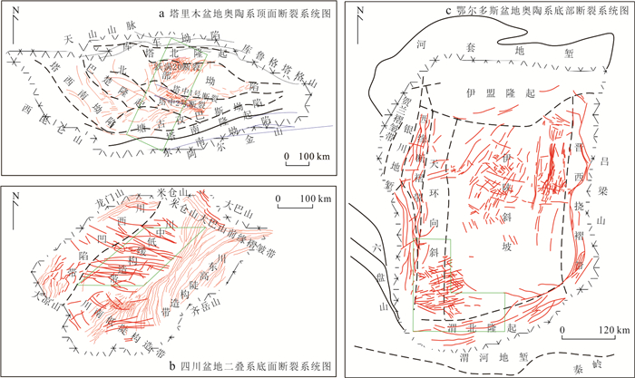
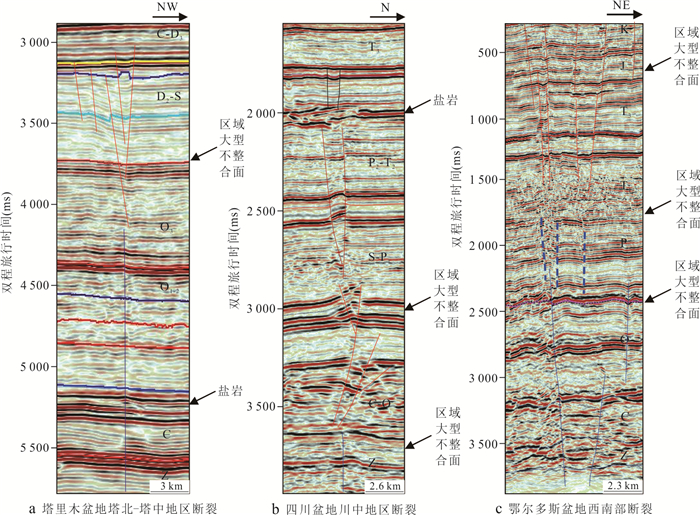
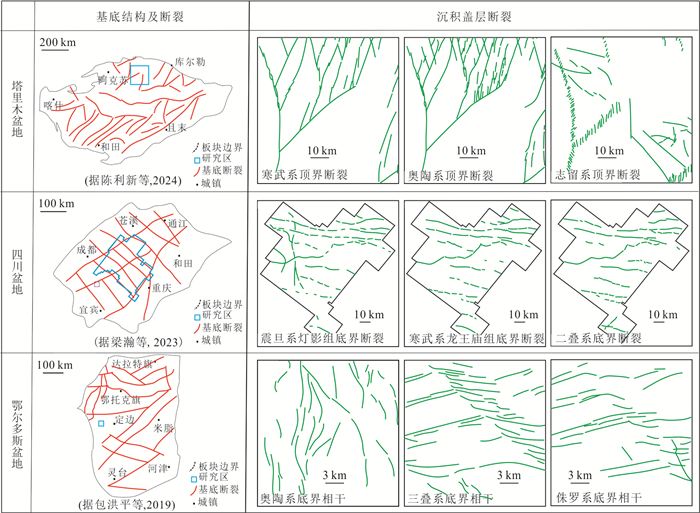
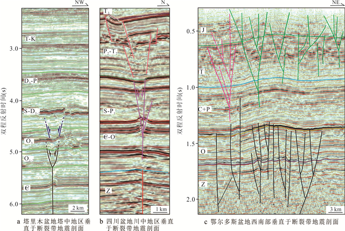
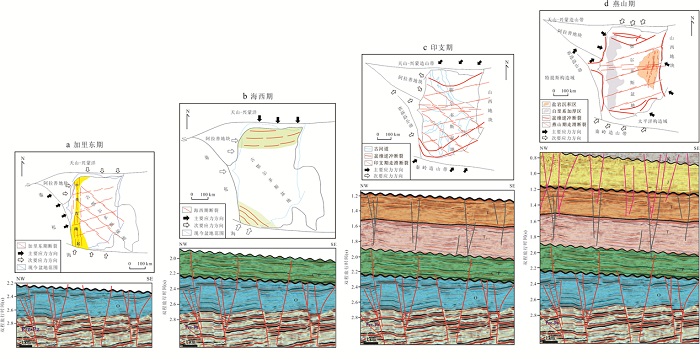
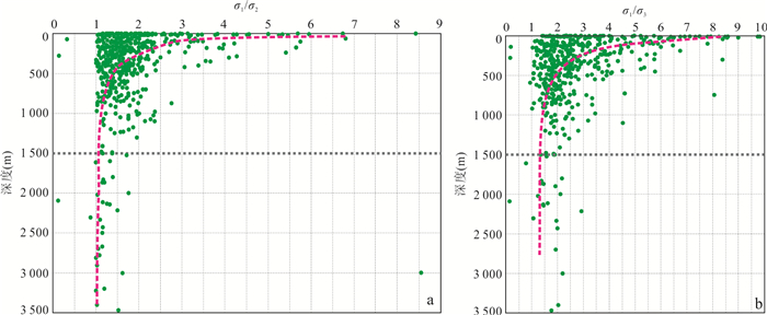
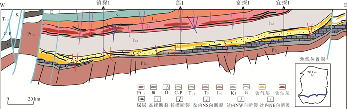
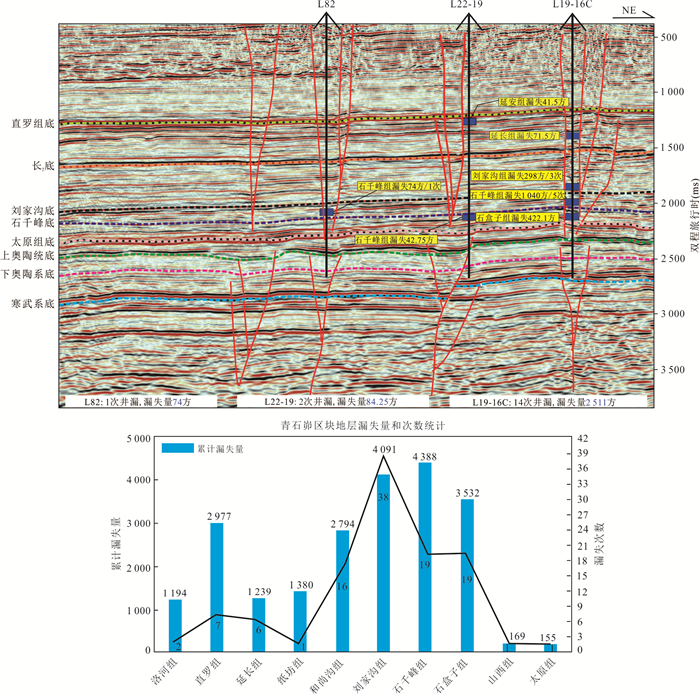
The widespread development of intra-cratonic strike-slip faults has been confirmed by exploration activities, with successive major discoveries such as the Shunbei and Fuman oilfields along these fault zones. In recent years, the extensive acquisition and in-depth application of 3D seismic data have further substantiated the distinct characteristic of vertical stratification along strike-slip faults. This recognition holds significant implications for advancing fundamental geological theories of cratonic basins and for pioneering novel domains in hydrocarbon exploration.This study focuses on the Tarim, Sichuan, and Ordos basins in central-western China. Addressing the scientific question regarding the vertical stratification of strike-slip faults, it systematically synthesizes developmental patterns, genetic mechanisms, and petroleum geological significance through comprehensive investigation, comparative analysis, and integrated interpretation. The research yields five key findings.(1) Strike-slip fault stratification is a localized phenomenon within cratonic superimposed basins, rather than a regionally extensive characteristic. It is prominently developed in the Tabei-Tazhong area of the Tarim Basin, the central Sichuan Basin, and the southwestern Ordos Basin. (2) Within these three major cratonic superimposed basins, strike-slip fault stratification exhibits four principal manifestations. ① Major regional unconformities serve as the primary detachment interfaces for vertical fault segmentation; ② Vertical stacking between different structural layers occurs in both strike-parallel and strike-divergent configurations; ③ Within individual structural layers, strike-slip faults may not be fully penetrative vertically, often separated by interval zones of appreciable thickness; ④Stratification characteristics are not exclusively controlled by basement fault reactivation.(3) Strike-slip fault stratification is classified into two genetic types: inter-layer stratification (between structural layers) and intra-layer stratification (within a single structural layer). In the Tabei-Tazhong area, central Sichuan, and southwestern Ordos Basin, the inter-layer type exhibits "two-layer", "three-layer", and "four-layer" architectures, respectively. The intra-layer type is characterized by faults terminating within specific strata, with significant interval zones-such as within the Upper Ordovician, Lower Cambrian, Carboniferous-Permian, and Lower Triassic formations, respectively-where faulting is absent, constituting crucial vertical separations.(4) Strike-slip fault stratification is governed by three essential conditions: a stable crystalline basement, a thick sedimentary cover, and compressional stress. Inter-layer stratification is primarily controlled by polyphase regional stress fields, whereas intra-layer stratification is mainly influenced by the downward attenuation of contemporaneous tectonic stress and variations in deep structural settings.(5) The stratification patterns of strike-slip faults not only corroborate the existence of regional vertical tectonic decoupling within cratonic superimposed basins but also provide a framework for understanding the deep-seated mechanisms governing vertically stratified and independently accumulated hydrocarbon reservoirs in cratonic interiors. Currently, studies in the Ordos Basin demonstrate that the downward convergence zones of stratified strike-slip faults are frequently associated with the most severe drilling fluid losses. This understanding offers important theoretical support for drilling program design and early warning during engineering operations.
The widespread development of intra-cratonic strike-slip faults has been confirmed by exploration activities, with successive major discoveries such as the Shunbei and Fuman oilfields along these fault zones. In recent years, the extensive acquisition and in-depth application of 3D seismic data have further substantiated the distinct characteristic of vertical stratification along strike-slip faults. This recognition holds significant implications for advancing fundamental geological theories of cratonic basins and for pioneering novel domains in hydrocarbon exploration.This study focuses on the Tarim, Sichuan, and Ordos basins in central-western China. Addressing the scientific question regarding the vertical stratification of strike-slip faults, it systematically synthesizes developmental patterns, genetic mechanisms, and petroleum geological significance through comprehensive investigation, comparative analysis, and integrated interpretation. The research yields five key findings.(1) Strike-slip fault stratification is a localized phenomenon within cratonic superimposed basins, rather than a regionally extensive characteristic. It is prominently developed in the Tabei-Tazhong area of the Tarim Basin, the central Sichuan Basin, and the southwestern Ordos Basin. (2) Within these three major cratonic superimposed basins, strike-slip fault stratification exhibits four principal manifestations. ① Major regional unconformities serve as the primary detachment interfaces for vertical fault segmentation; ② Vertical stacking between different structural layers occurs in both strike-parallel and strike-divergent configurations; ③ Within individual structural layers, strike-slip faults may not be fully penetrative vertically, often separated by interval zones of appreciable thickness; ④Stratification characteristics are not exclusively controlled by basement fault reactivation.(3) Strike-slip fault stratification is classified into two genetic types: inter-layer stratification (between structural layers) and intra-layer stratification (within a single structural layer). In the Tabei-Tazhong area, central Sichuan, and southwestern Ordos Basin, the inter-layer type exhibits "two-layer", "three-layer", and "four-layer" architectures, respectively. The intra-layer type is characterized by faults terminating within specific strata, with significant interval zones-such as within the Upper Ordovician, Lower Cambrian, Carboniferous-Permian, and Lower Triassic formations, respectively-where faulting is absent, constituting crucial vertical separations.(4) Strike-slip fault stratification is governed by three essential conditions: a stable crystalline basement, a thick sedimentary cover, and compressional stress. Inter-layer stratification is primarily controlled by polyphase regional stress fields, whereas intra-layer stratification is mainly influenced by the downward attenuation of contemporaneous tectonic stress and variations in deep structural settings.(5) The stratification patterns of strike-slip faults not only corroborate the existence of regional vertical tectonic decoupling within cratonic superimposed basins but also provide a framework for understanding the deep-seated mechanisms governing vertically stratified and independently accumulated hydrocarbon reservoirs in cratonic interiors. Currently, studies in the Ordos Basin demonstrate that the downward convergence zones of stratified strike-slip faults are frequently associated with the most severe drilling fluid losses. This understanding offers important theoretical support for drilling program design and early warning during engineering operations.
2026, 51(7): 2663-2681.
doi: 10.3799/dqkx.2026.105
Abstract:
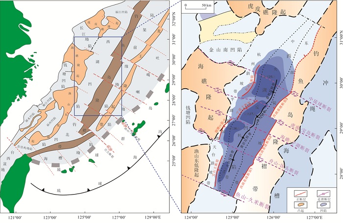
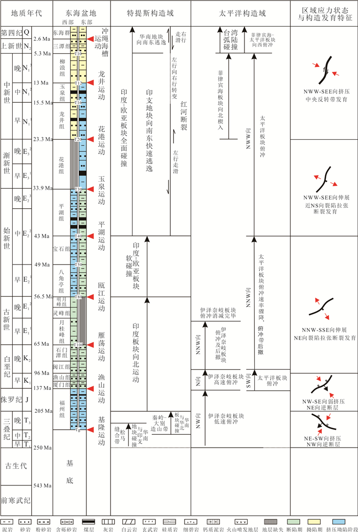
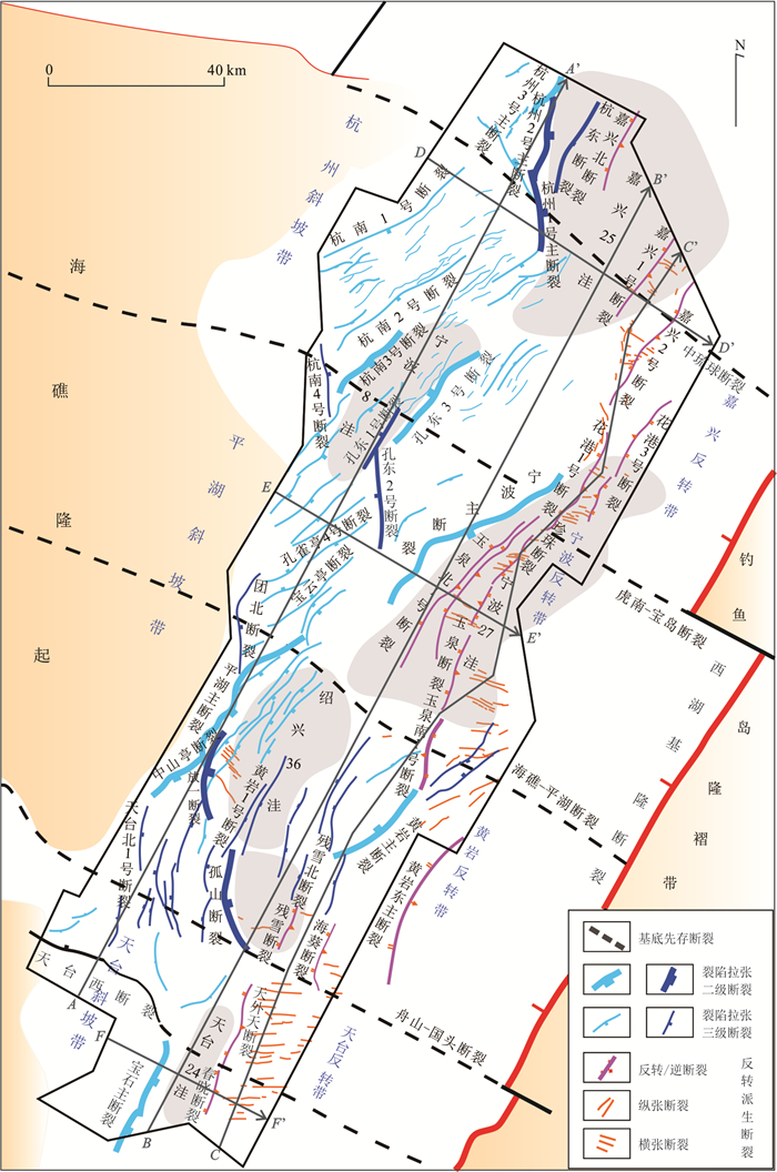
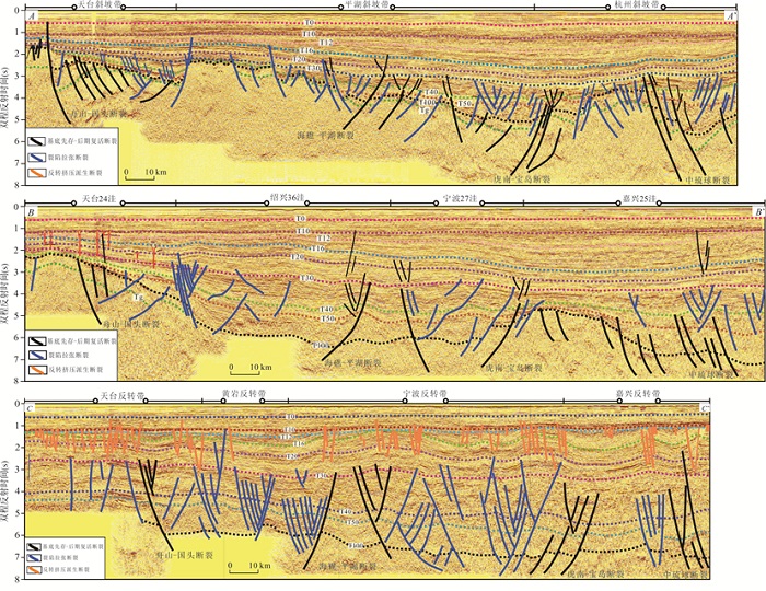
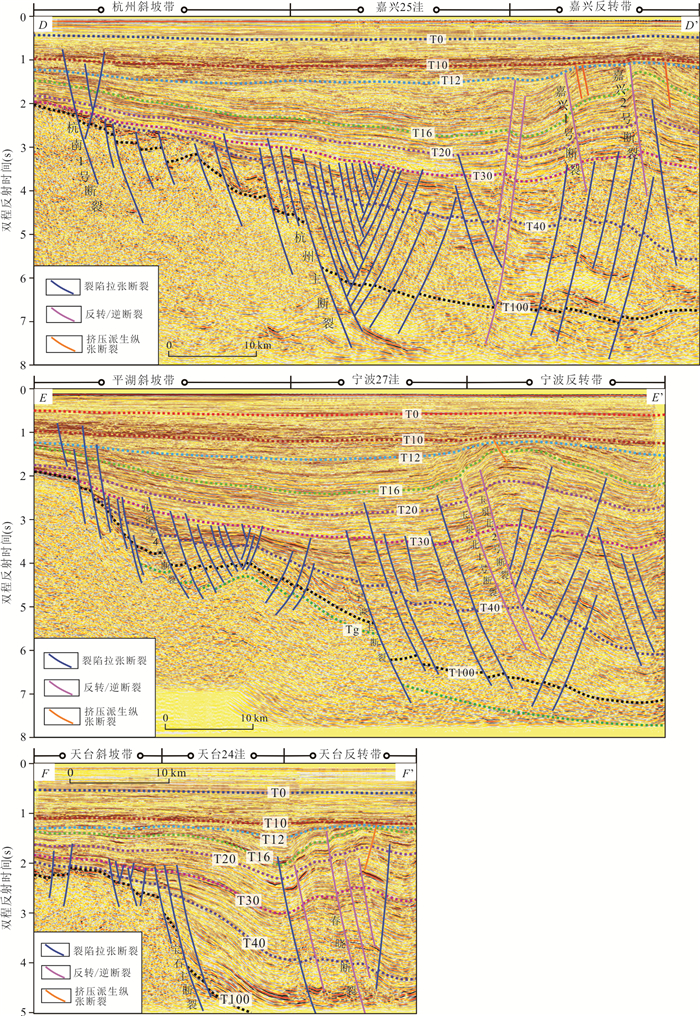
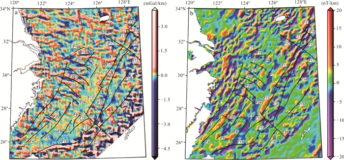
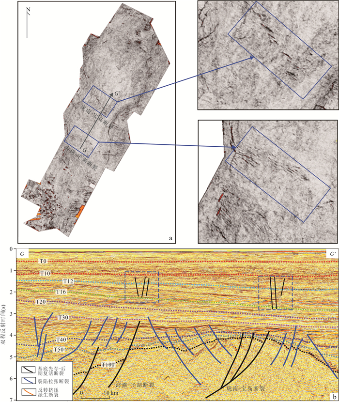
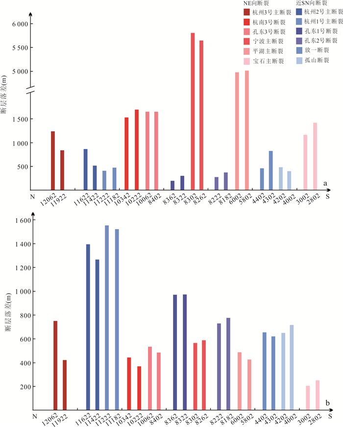
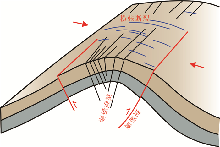
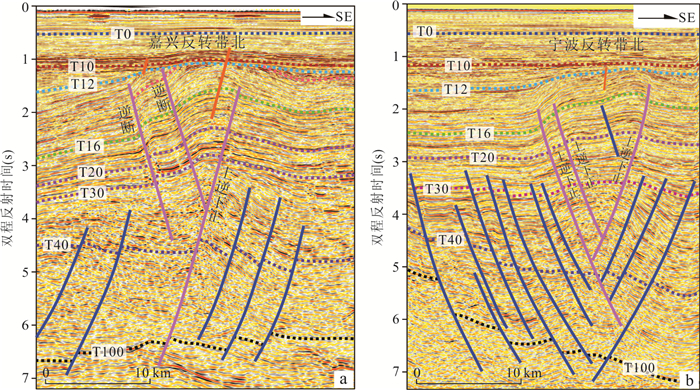
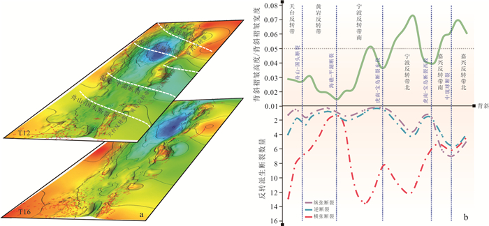
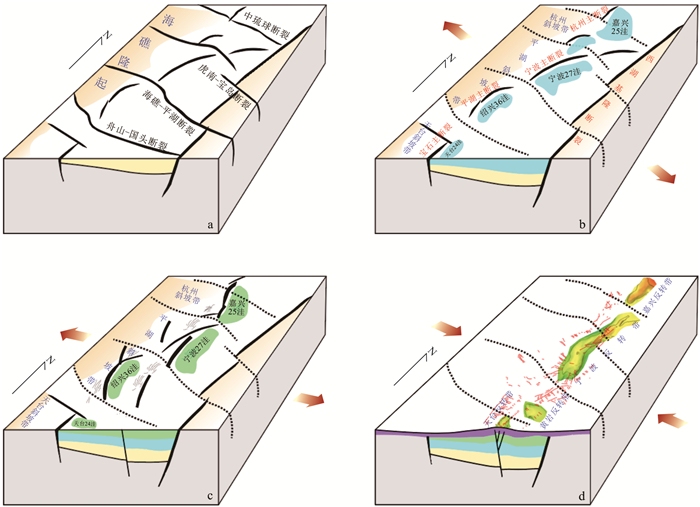
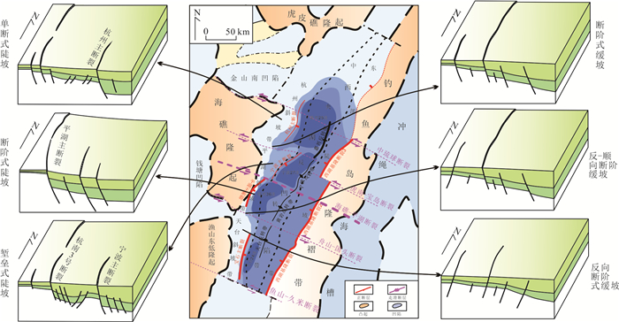
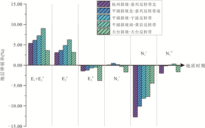
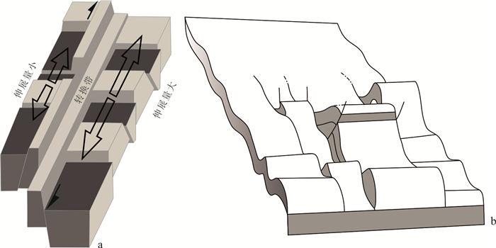
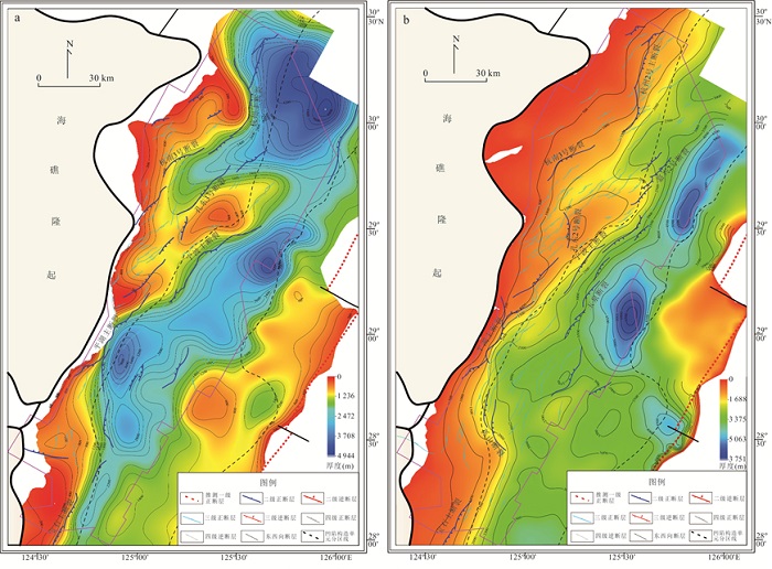
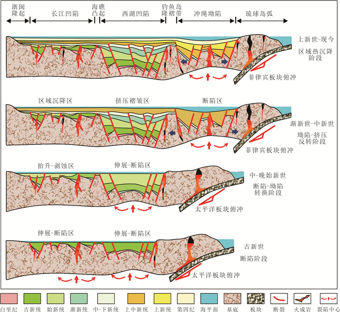
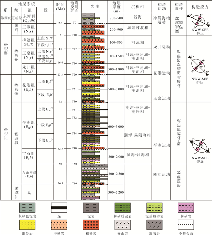
The Xihu Sag is an important Meso-Cenozoic superimposed petroliferous basin in the East China Sea Shelf Basin offshore eastern China. The spatiotemporal variation characteristics of its fault system development not only determine the basin structure but also control hydrocarbon accumulation. This paper uses the latest integrated 3D seismic data and drilling data to systematically analyze the developmental characteristics and basin-controlling effects of the fault system in the Xihu Sag, classifying three genetically distinct fault types: pre-existing Cenozoic basement faults, rift-related extensional faults, and inversion-related compressional faults. It clarifies the north-south partitioning effect of NW (NWW)-trending pre-existing basement faults on the Cenozoic slope belt and central inversion zone of the Xihu Sag; reveals the transition from NE-SW-trending faults dominating the early rifting stage (pre-Pinghu Formation deposition) to near SN-trending faults dominating the late rifting stage (Pinghu Formation deposition); and elucidates the genetic relationships between compressional inversion fault systems (longitudinal tension, transverse tension, and reverse faults) formed during the Longjing and Okinawa tectonic movements and inversion anticlines. The research results hold theoretical significance for understanding the tectonic differential evolution process and mechanisms of the Xihu Sag and even the entire East China Sea Shelf Basin, and can provide guidance for hydrocarbon exploration practices in this region.
The Xihu Sag is an important Meso-Cenozoic superimposed petroliferous basin in the East China Sea Shelf Basin offshore eastern China. The spatiotemporal variation characteristics of its fault system development not only determine the basin structure but also control hydrocarbon accumulation. This paper uses the latest integrated 3D seismic data and drilling data to systematically analyze the developmental characteristics and basin-controlling effects of the fault system in the Xihu Sag, classifying three genetically distinct fault types: pre-existing Cenozoic basement faults, rift-related extensional faults, and inversion-related compressional faults. It clarifies the north-south partitioning effect of NW (NWW)-trending pre-existing basement faults on the Cenozoic slope belt and central inversion zone of the Xihu Sag; reveals the transition from NE-SW-trending faults dominating the early rifting stage (pre-Pinghu Formation deposition) to near SN-trending faults dominating the late rifting stage (Pinghu Formation deposition); and elucidates the genetic relationships between compressional inversion fault systems (longitudinal tension, transverse tension, and reverse faults) formed during the Longjing and Okinawa tectonic movements and inversion anticlines. The research results hold theoretical significance for understanding the tectonic differential evolution process and mechanisms of the Xihu Sag and even the entire East China Sea Shelf Basin, and can provide guidance for hydrocarbon exploration practices in this region.
2026, 51(7): 2682-2702.
doi: 10.3799/dqkx.2026.119
Abstract:
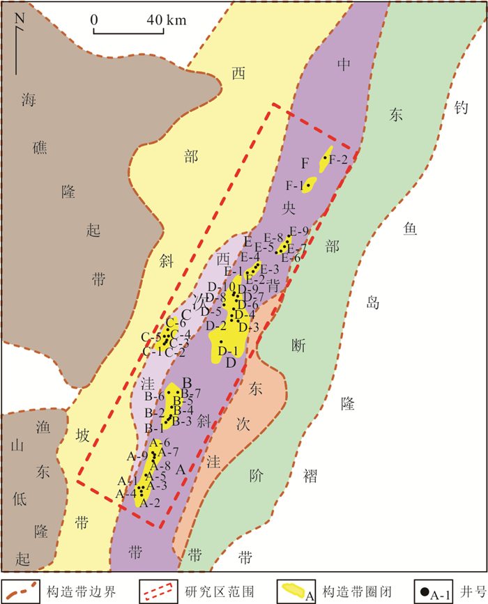
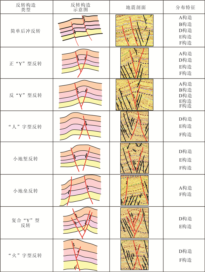
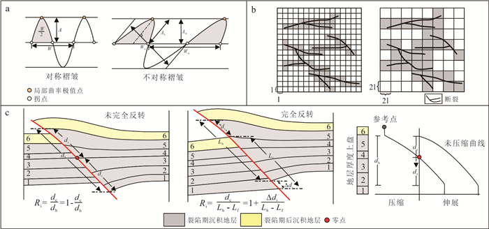
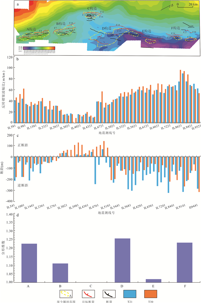
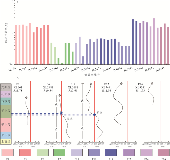
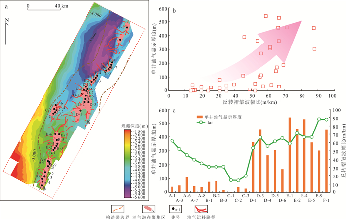
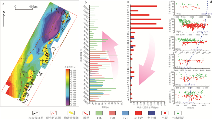
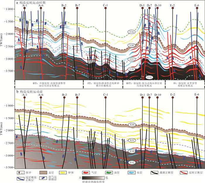
The Xihu Depression underwent significant tectonic inversion during the Miocene, underscoring the importance of elucidating its coupling effects with hydrocarbon accumulation. This study utilizes various data, including 3D seismic, well logging, and employs multiple methods for a quantitative assessment of tectonic inversion intensity. The results indicate that the depression-uplift transition in the central anticline zone is pronounced, featuring the development of near EW extensional normal faults in the shallow anticline core, while early NNE-NE trending normal faults underwent activation through compressional inversion. Based on the characteristics of inversion normal faults, eight types of inverted structural styles have been classified. Through quantitative evaluations using fold amplitude ratios, fracture fractals, and fault inversion rates, it established that the central anticline belt exhibits a north-strong and south-weak pattern of tectonic inversion intensity, based on which four characteristic hydrocarbon accumulation models were established: Type I: fault-sand coupling under weak structural inversion; Type II: deep localized enrichment driven by intensive structural adjustment under moderate-to-strong inversion; Type III: vertical multi-stratigraphic enrichment facilitated by relay-style faulting under strong inversion; Type IV: large-scale enrichment preserved by non-penetrating faults under strong tectonic inversion. This research enhances the understanding of hydrocarbon accumulation mechanisms within the context of tectonic inversion in the Xihu Depression and provides valuable insights for exploration in analogous basins.
The Xihu Depression underwent significant tectonic inversion during the Miocene, underscoring the importance of elucidating its coupling effects with hydrocarbon accumulation. This study utilizes various data, including 3D seismic, well logging, and employs multiple methods for a quantitative assessment of tectonic inversion intensity. The results indicate that the depression-uplift transition in the central anticline zone is pronounced, featuring the development of near EW extensional normal faults in the shallow anticline core, while early NNE-NE trending normal faults underwent activation through compressional inversion. Based on the characteristics of inversion normal faults, eight types of inverted structural styles have been classified. Through quantitative evaluations using fold amplitude ratios, fracture fractals, and fault inversion rates, it established that the central anticline belt exhibits a north-strong and south-weak pattern of tectonic inversion intensity, based on which four characteristic hydrocarbon accumulation models were established: Type I: fault-sand coupling under weak structural inversion; Type II: deep localized enrichment driven by intensive structural adjustment under moderate-to-strong inversion; Type III: vertical multi-stratigraphic enrichment facilitated by relay-style faulting under strong inversion; Type IV: large-scale enrichment preserved by non-penetrating faults under strong tectonic inversion. This research enhances the understanding of hydrocarbon accumulation mechanisms within the context of tectonic inversion in the Xihu Depression and provides valuable insights for exploration in analogous basins.
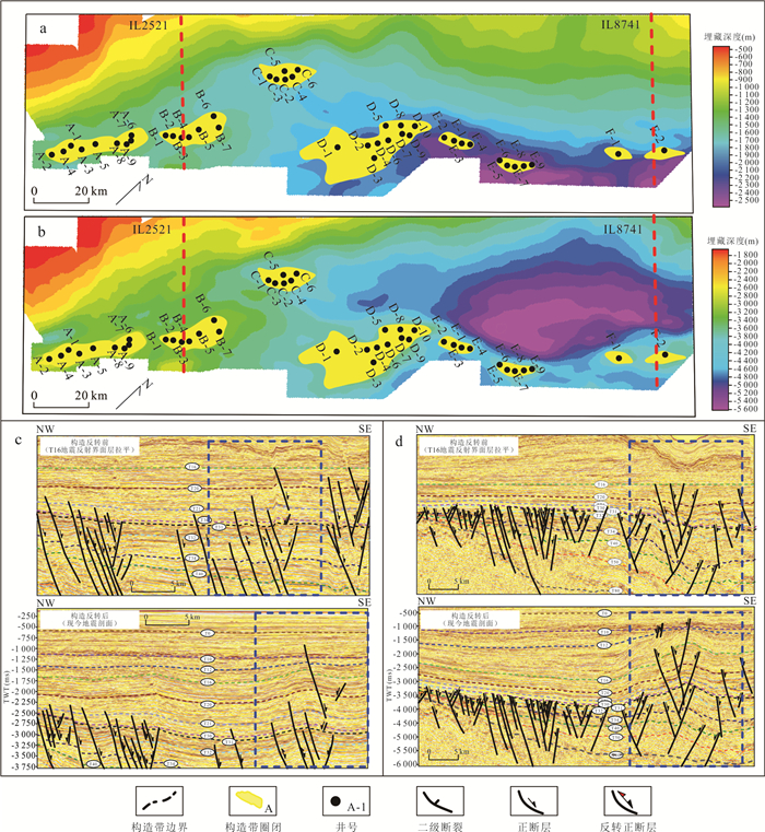
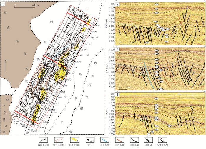
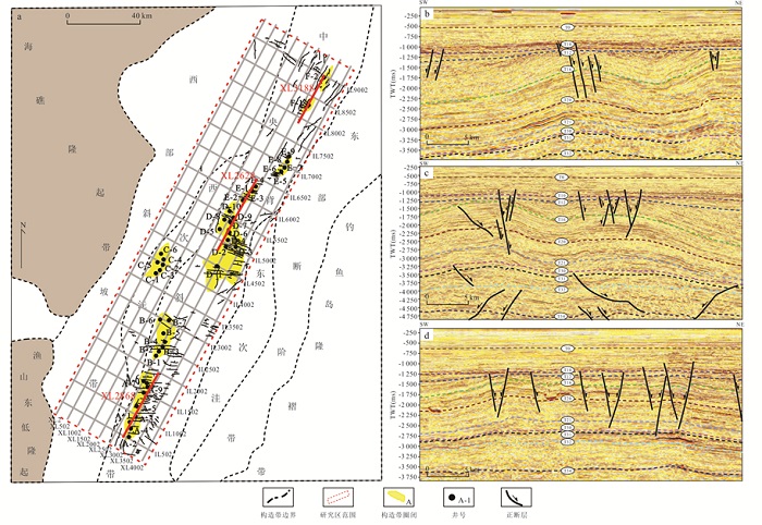
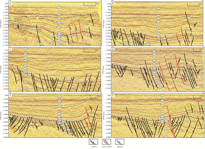
2026, 51(7): 2703-2715.
doi: 10.3799/dqkx.2026.139
Abstract:
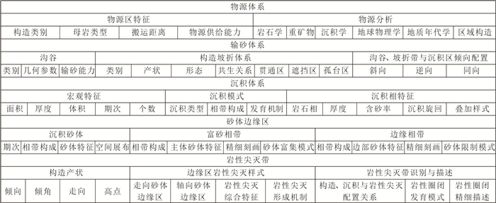
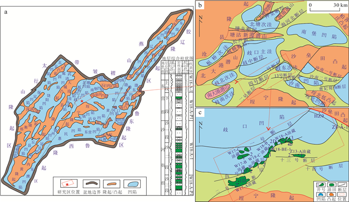
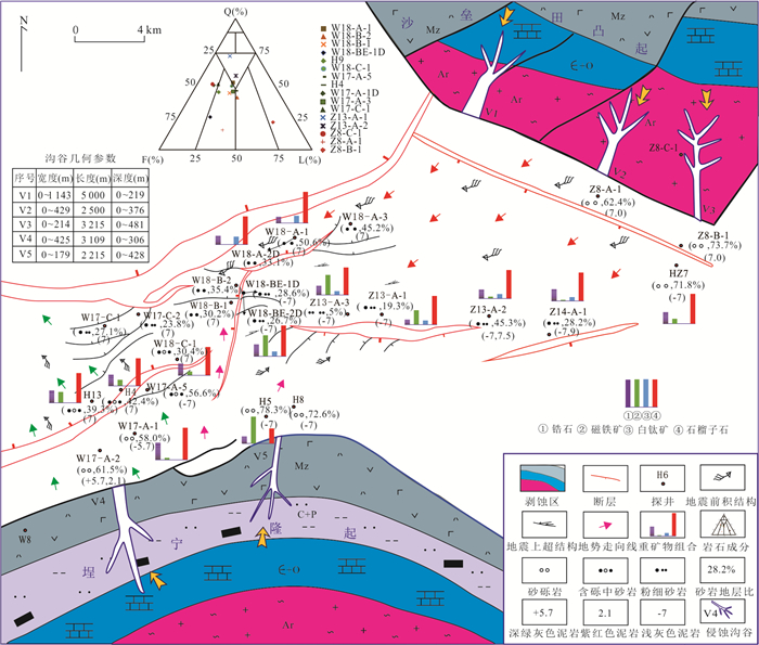
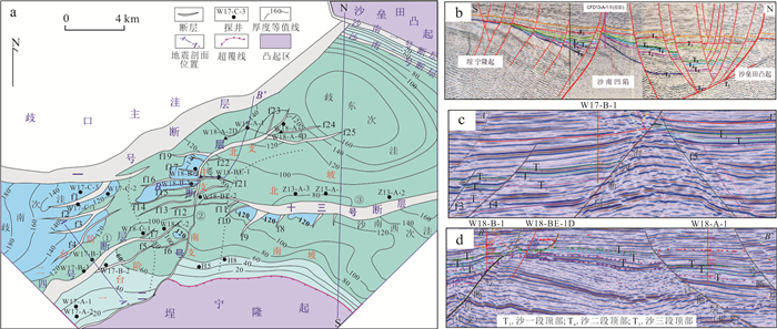
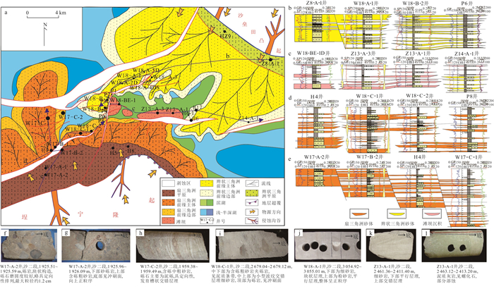
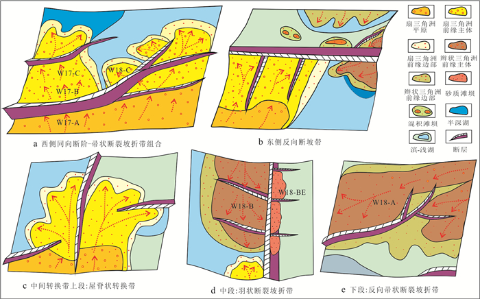
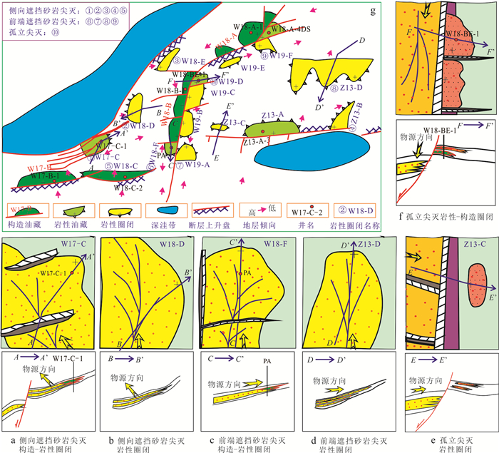
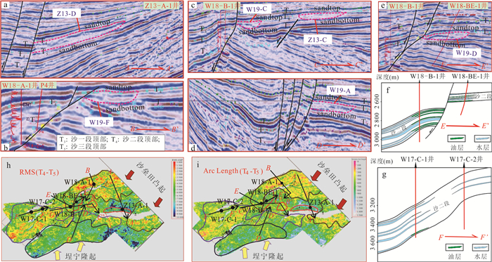
Significant progress has been made in applying the source-to-sink system to depositional process restoration, sand distribution control, and sandbody enrichment prediction in continental basins. However, in settings with multiple source areas and multiple structural slope breaks, research of the marginal depositional facies belts, sandbody pinch-outs, and the development of lithologic traps remains scarce. Taking the southern slope belt of Qikou Sag as an example, based on drilling data, laboratory data, and full-coverage 3D seismic data, we comprehensively analyze source-to-sink system architecture and genetic model of lithologic traps. Firstly, division and correlation of provenance systems are carried out. Then, the internal architecture and syndepositional relationships of tectonic slope-break zones are analyzed. Finally, the configuration of symbiotic structural slope-break zones is discussed from source to sink, and sandbody enrichment zone and pinch-out zone are identified. A total of 15 lithologic traps have been newly discovered or confirmed in the slope zone, covering a total area of 21.5 km². The research indicates that lithologic traps within the slope belt are controlled by structural slope-break zones and depositional facies types, the most favorable locations occur in the semi-sheltered zone and isolated platform areas, where three main trap types develop: laterally-sealed sandstone pinch-outs, frontally-sealed sandstone pinch-outs, and isolated pinch-out traps. Research on sand control and trap development under the source-to-sink system framework can effectively predict lithologic traps within slope belts. This methodology shows significant potential for lithologic reservoirs exploration in complex slope belts.
Significant progress has been made in applying the source-to-sink system to depositional process restoration, sand distribution control, and sandbody enrichment prediction in continental basins. However, in settings with multiple source areas and multiple structural slope breaks, research of the marginal depositional facies belts, sandbody pinch-outs, and the development of lithologic traps remains scarce. Taking the southern slope belt of Qikou Sag as an example, based on drilling data, laboratory data, and full-coverage 3D seismic data, we comprehensively analyze source-to-sink system architecture and genetic model of lithologic traps. Firstly, division and correlation of provenance systems are carried out. Then, the internal architecture and syndepositional relationships of tectonic slope-break zones are analyzed. Finally, the configuration of symbiotic structural slope-break zones is discussed from source to sink, and sandbody enrichment zone and pinch-out zone are identified. A total of 15 lithologic traps have been newly discovered or confirmed in the slope zone, covering a total area of 21.5 km². The research indicates that lithologic traps within the slope belt are controlled by structural slope-break zones and depositional facies types, the most favorable locations occur in the semi-sheltered zone and isolated platform areas, where three main trap types develop: laterally-sealed sandstone pinch-outs, frontally-sealed sandstone pinch-outs, and isolated pinch-out traps. Research on sand control and trap development under the source-to-sink system framework can effectively predict lithologic traps within slope belts. This methodology shows significant potential for lithologic reservoirs exploration in complex slope belts.
2026, 51(7): 2716-2730.
doi: 10.3799/dqkx.2026.205
Abstract:
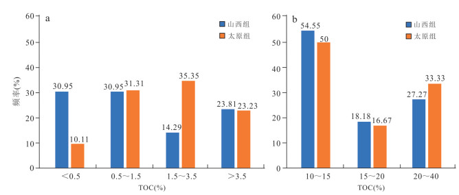
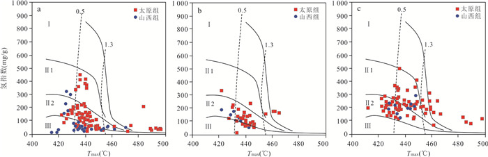
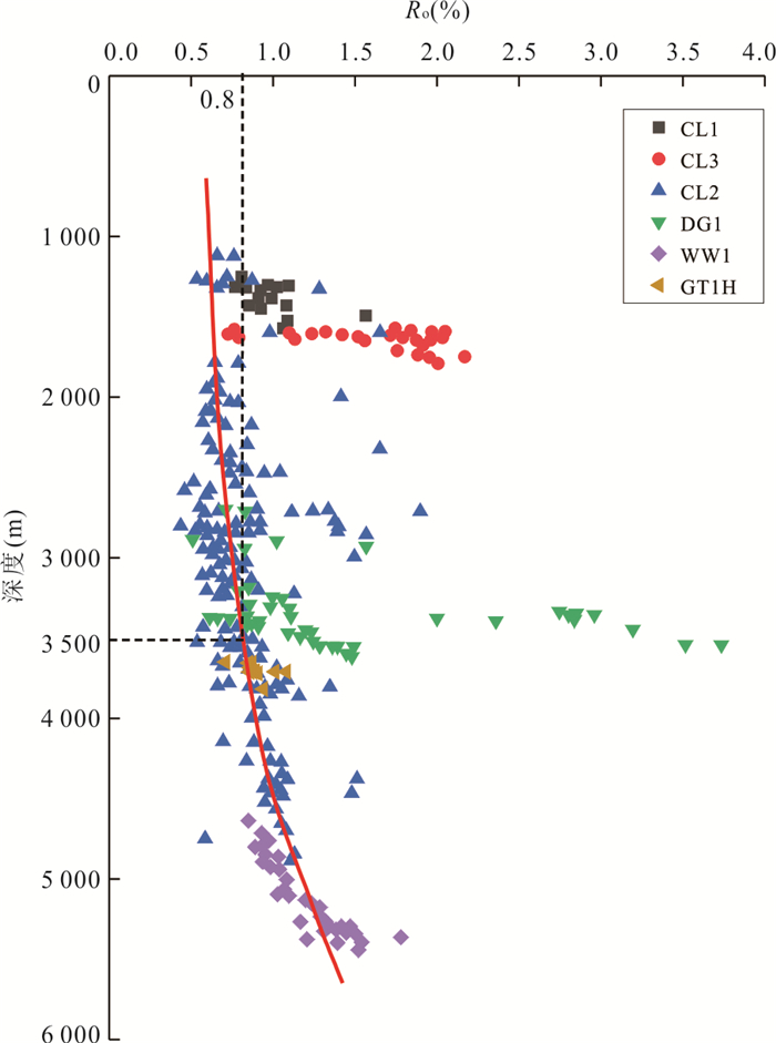
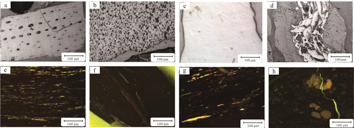
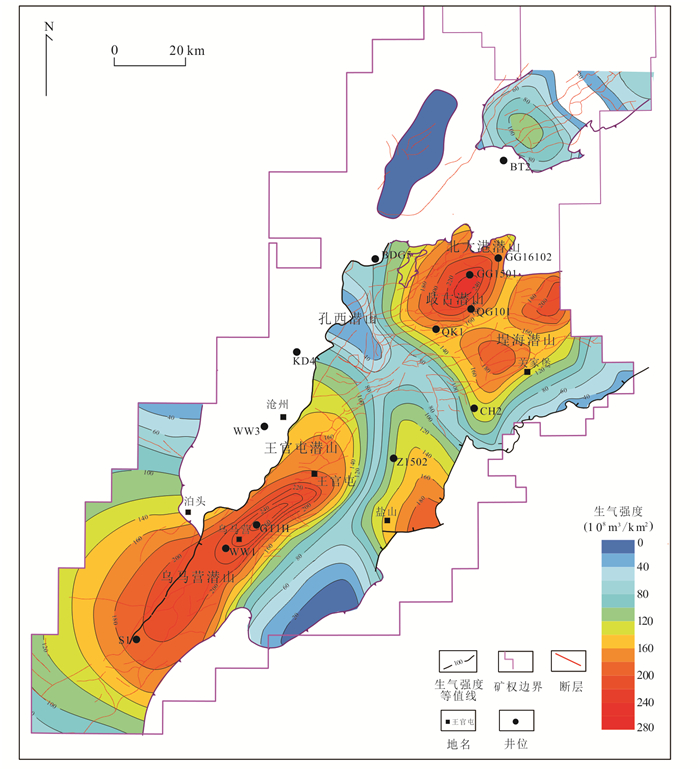
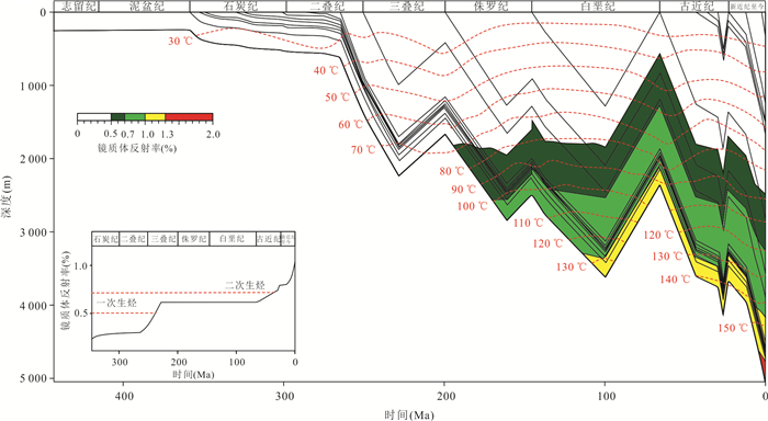
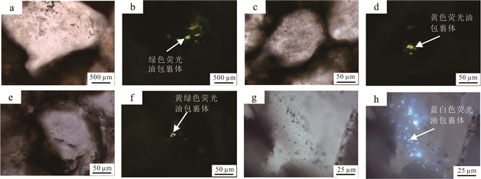
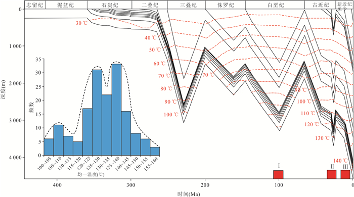
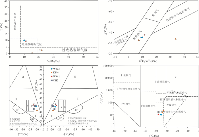
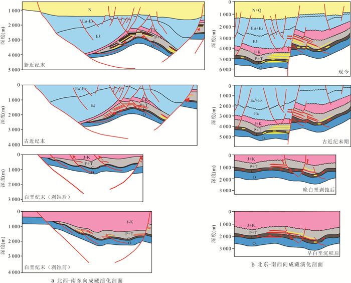
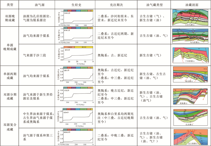
The Carboniferous-Permian coaly source rocks of the Upper Paleozoic in the Huanghua Depression constitute the principal material basis for hydrocarbon accumulation within buried-hill reservoirs. However, stratigraphic differences in hydrocarbon generation and their control on accumulation patterns remain poorly constrained. Focusing on the Late Paleozoic coal-bearing strata, this study integrates coal maceral analysis, organic geochemistry, and typical buried-hill reservoir dissection to systematically compare the Taiyuan and Shanxi formations. Combined with typical buried-hill reservoir dissection and accumulation process reconstruction, the mechanisms of hydrocarbon enrichment and reservoir formation models are clarified.Results indicate that both formations exhibit high organic matter abundance and are classified as good to excellent source rocks. Vitrinite is the dominant maceral, and kerogen is primarily type Ⅱ2. The Taiyuan Formation contains relatively higher proportions of vitrinite and exinite, making it the dominant hydrocarbon-supplying interval in the study area. Hydrocarbon evolution is characterized by an "early oil-late gas"pattern, namely oil generation first and gas generation later. Reservoir formation experienced multiple stages, including initial charging in the Early Cretaceous, partial destruction in the Late Cretaceous, re-accumulation in the Paleogene, and superimposed charging since the Neogene. Hydrocarbon sourcing shows clear differentiation, forming a composite supply system of coal-derived gas and Paleogene oil.Since the Paleogene, the Qibei-Chenghai and Wumaying-Wangguantun areas have developed high secondary gas-generation intensity, which provided an important material basis for late-stage gas charging in buried hills.Five accumulation models are established: (1) dual-source late-stage accumulation; (2) single-source late-stage accumulation; (3) single-source two-stage accumulation; (4) dual-source staged accumulation; and (5) dual-source composite accumulation.Differential enrichment of hydrocarbons within buried hills is jointly controlled by source rock quality, hydrocarbon generation intensity, composite migration systems, and tectonic activities, among which the matching relationship between fault activity and effective hydrocarbon supply is the key to multi-stage accumulation. These results provide a geological basis for understanding coal-related hydrocarbon accumulation mechanisms and for favorable zone evaluation.
The Carboniferous-Permian coaly source rocks of the Upper Paleozoic in the Huanghua Depression constitute the principal material basis for hydrocarbon accumulation within buried-hill reservoirs. However, stratigraphic differences in hydrocarbon generation and their control on accumulation patterns remain poorly constrained. Focusing on the Late Paleozoic coal-bearing strata, this study integrates coal maceral analysis, organic geochemistry, and typical buried-hill reservoir dissection to systematically compare the Taiyuan and Shanxi formations. Combined with typical buried-hill reservoir dissection and accumulation process reconstruction, the mechanisms of hydrocarbon enrichment and reservoir formation models are clarified.Results indicate that both formations exhibit high organic matter abundance and are classified as good to excellent source rocks. Vitrinite is the dominant maceral, and kerogen is primarily type Ⅱ2. The Taiyuan Formation contains relatively higher proportions of vitrinite and exinite, making it the dominant hydrocarbon-supplying interval in the study area. Hydrocarbon evolution is characterized by an "early oil-late gas"pattern, namely oil generation first and gas generation later. Reservoir formation experienced multiple stages, including initial charging in the Early Cretaceous, partial destruction in the Late Cretaceous, re-accumulation in the Paleogene, and superimposed charging since the Neogene. Hydrocarbon sourcing shows clear differentiation, forming a composite supply system of coal-derived gas and Paleogene oil.Since the Paleogene, the Qibei-Chenghai and Wumaying-Wangguantun areas have developed high secondary gas-generation intensity, which provided an important material basis for late-stage gas charging in buried hills.Five accumulation models are established: (1) dual-source late-stage accumulation; (2) single-source late-stage accumulation; (3) single-source two-stage accumulation; (4) dual-source staged accumulation; and (5) dual-source composite accumulation.Differential enrichment of hydrocarbons within buried hills is jointly controlled by source rock quality, hydrocarbon generation intensity, composite migration systems, and tectonic activities, among which the matching relationship between fault activity and effective hydrocarbon supply is the key to multi-stage accumulation. These results provide a geological basis for understanding coal-related hydrocarbon accumulation mechanisms and for favorable zone evaluation.
2026, 51(7): 2731-2746.
doi: 10.3799/dqkx.2026.192
Abstract:
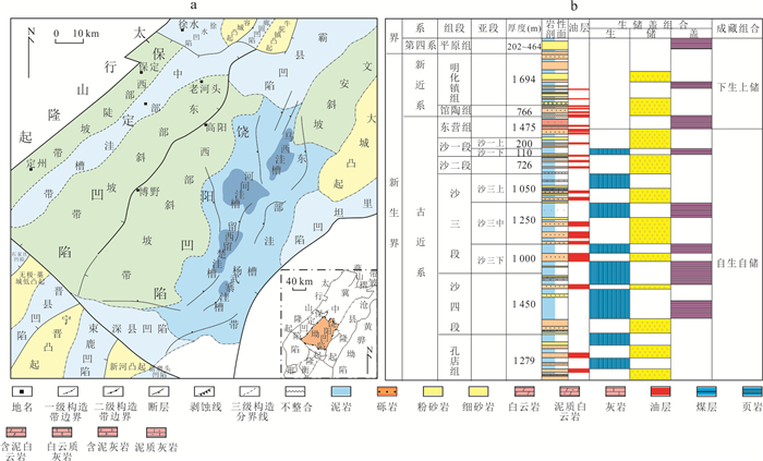
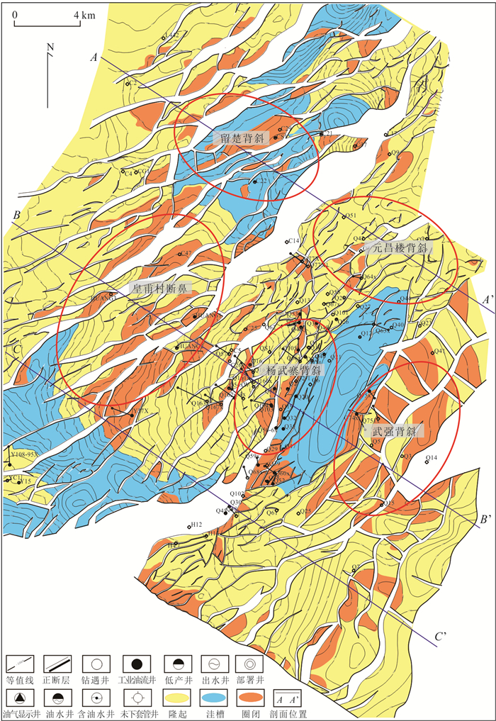
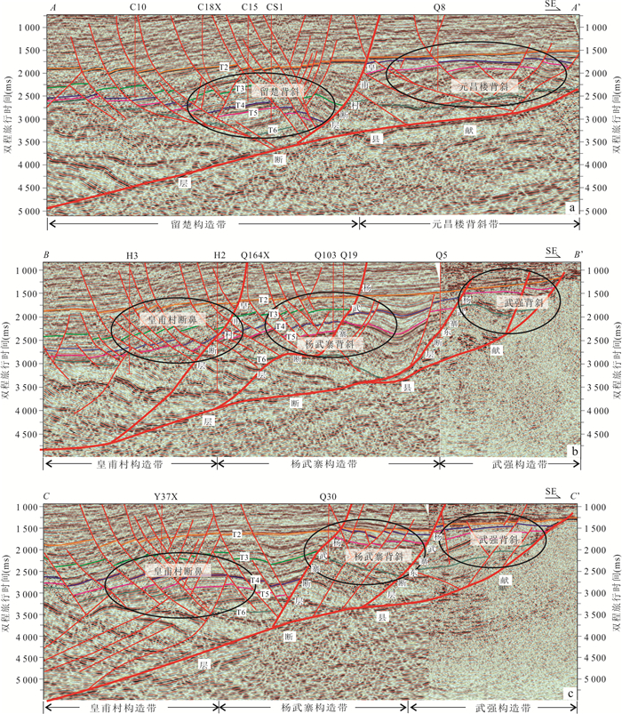
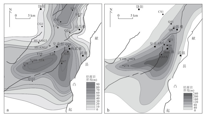
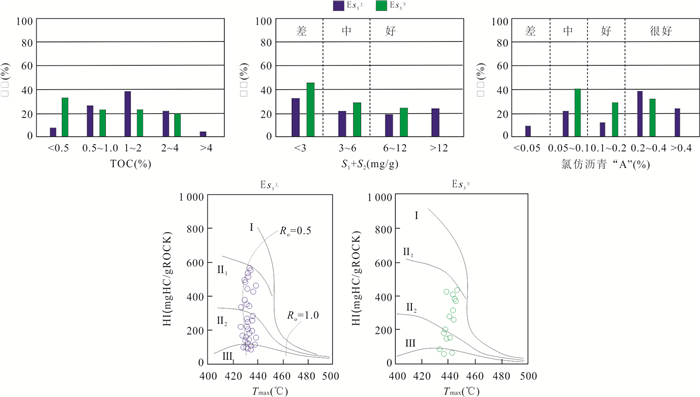
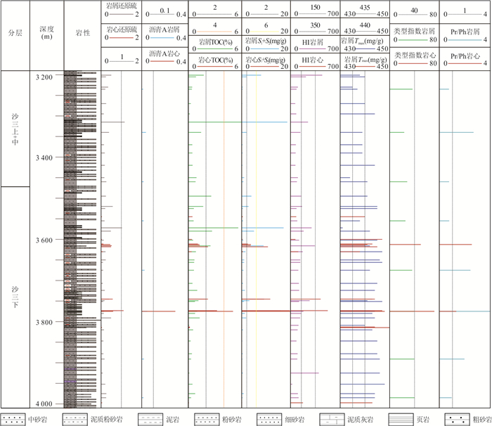
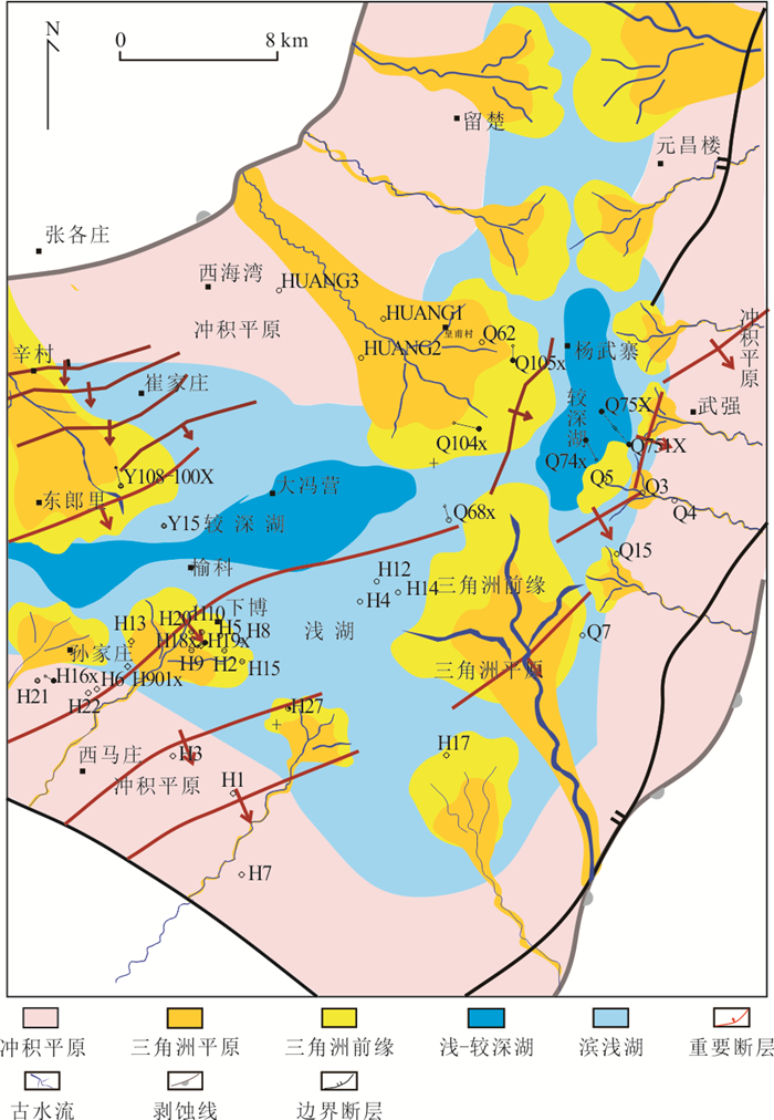
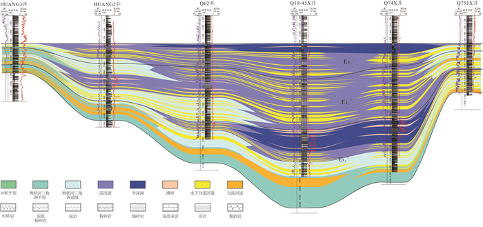
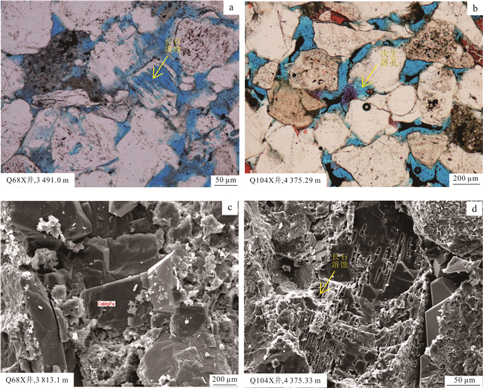
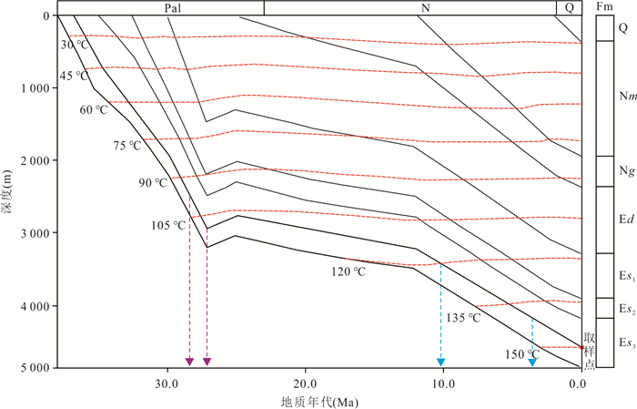
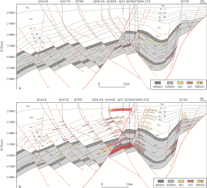
To clarify the hydrocarbon accumulation conditions and enrichment patterns in the deep strata of the southern Raoyang Sag, and to address the exploration challenges of unclear resource potential, strong reservoir heterogeneity, and unknown accumulation models, this study systematically analyzed source rock characteristics, reservoir development mechanisms, and structural settings, and subsequently established and validated accumulation models. The results show that the lower submember of the third member of the Shahejie Formation (Es3下) developed high-quality source rocks in a semi-saline lacustrine environment. Braided river delta sand bodies formed effective reservoirs through organic acid dissolution and early hydrocarbon charging. A large-scale detachment and decollement structural setting controlled multiple favorable anticlinal belts. Based on these findings, two accumulation models (intra-source and near-source) were established. Following the near-source model, Well Q104X was drilled in the Yangwuzhai structural belt and yielded high-yield industrial oil flow, achieving a major exploration breakthrough in the deep strata. This study confirms that the deep strata of the Raoyang Sag possess conditions for large-scale hydrocarbon accumulation. The results provide an important reference for deep petroleum exploration in the Jizhong Depression and similar continental rift basins, and are of great significance for resource replacement and reserve/production growth in mature oil regions.
To clarify the hydrocarbon accumulation conditions and enrichment patterns in the deep strata of the southern Raoyang Sag, and to address the exploration challenges of unclear resource potential, strong reservoir heterogeneity, and unknown accumulation models, this study systematically analyzed source rock characteristics, reservoir development mechanisms, and structural settings, and subsequently established and validated accumulation models. The results show that the lower submember of the third member of the Shahejie Formation (Es3下) developed high-quality source rocks in a semi-saline lacustrine environment. Braided river delta sand bodies formed effective reservoirs through organic acid dissolution and early hydrocarbon charging. A large-scale detachment and decollement structural setting controlled multiple favorable anticlinal belts. Based on these findings, two accumulation models (intra-source and near-source) were established. Following the near-source model, Well Q104X was drilled in the Yangwuzhai structural belt and yielded high-yield industrial oil flow, achieving a major exploration breakthrough in the deep strata. This study confirms that the deep strata of the Raoyang Sag possess conditions for large-scale hydrocarbon accumulation. The results provide an important reference for deep petroleum exploration in the Jizhong Depression and similar continental rift basins, and are of great significance for resource replacement and reserve/production growth in mature oil regions.
2026, 51(7): 2747-2772.
doi: 10.3799/dqkx.2026.226
Abstract:
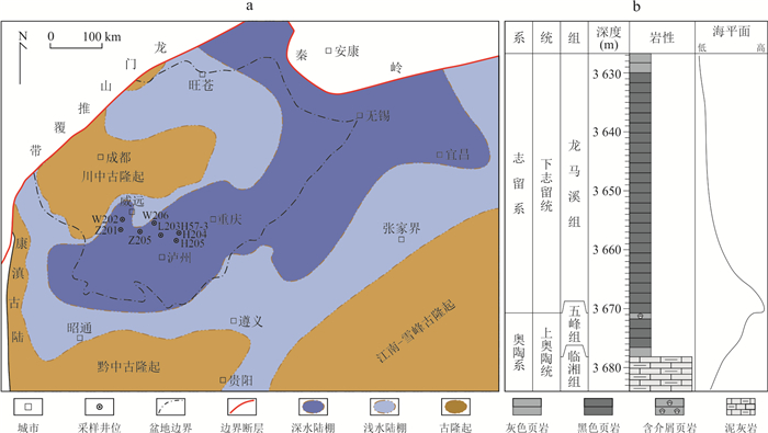
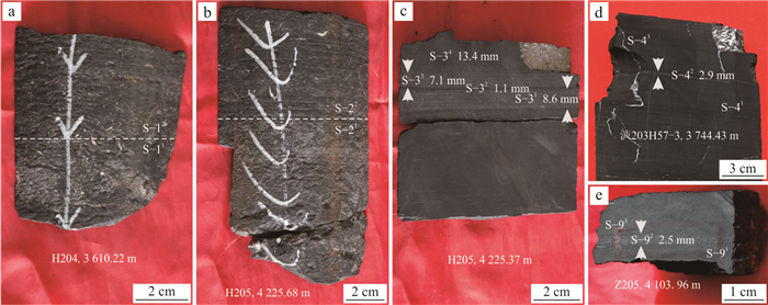
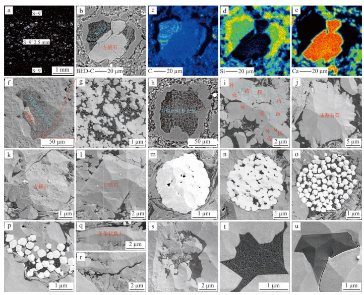
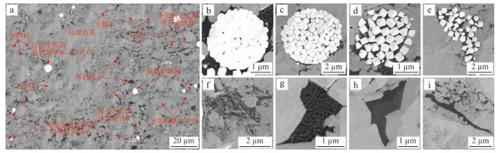
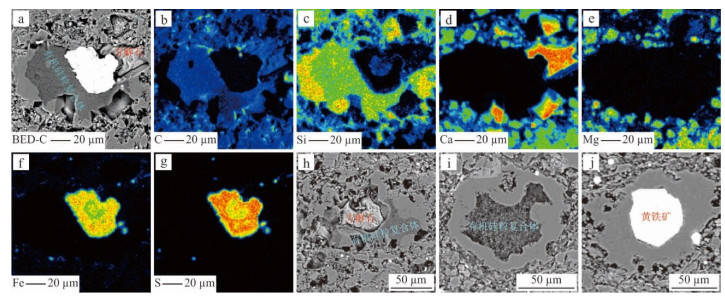
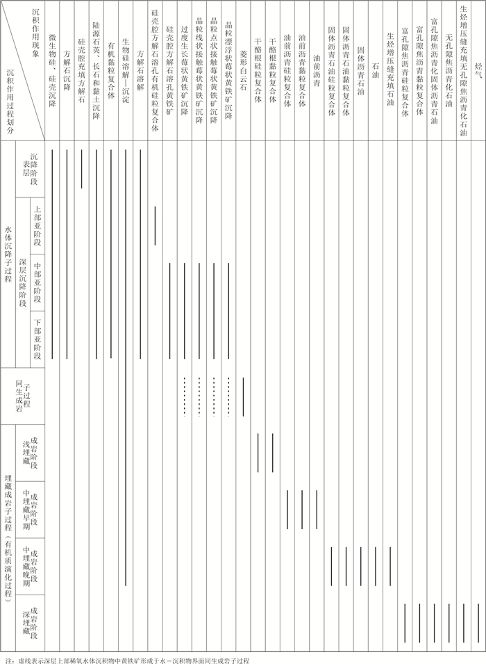
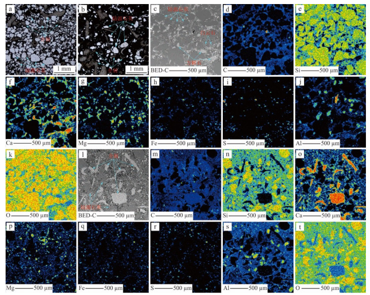
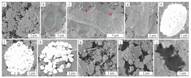
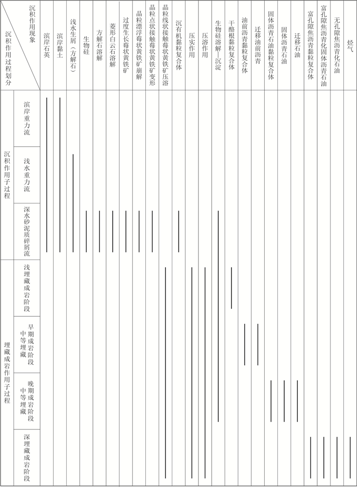
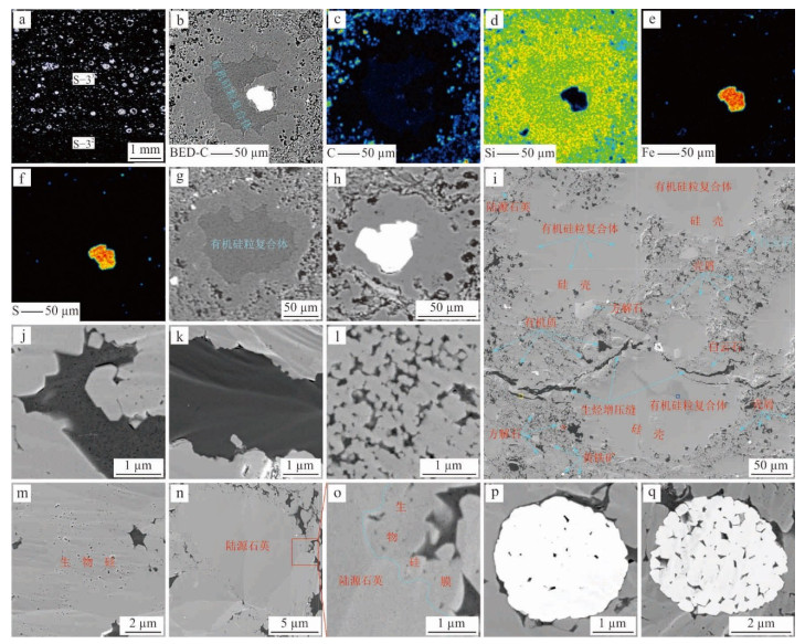
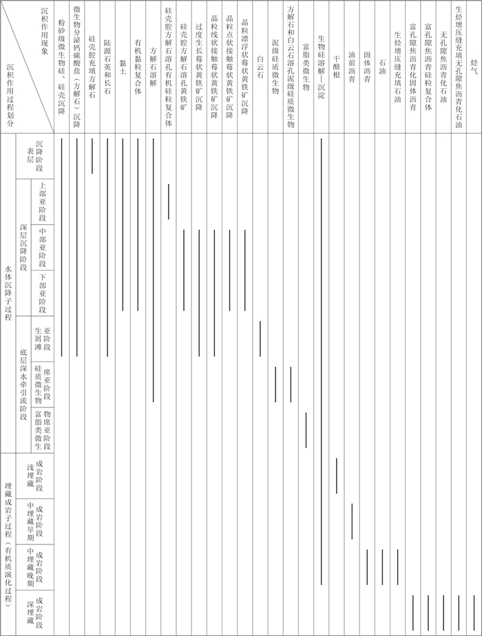
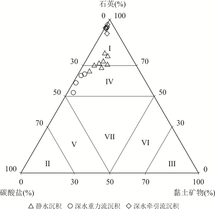
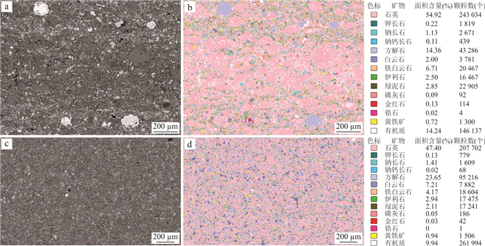
The sedimentation of marine shale is still unclear. The 18 study units were selected from 9 core samples of the Wufeng-Longmaxi formations in 7 wells of the Sichuan Basin. The sedimentation of marine shale was analyzed in orderly connections such as core, optical microscopy, electron probe microscopy and MAPS technology. The results show that the marine shale is an alternation superposition of still-water sedimentation, deep-water gravity flow sedimentation and deep-water traction current sedimentation, with the difference in the petrological marks of each sedimentation. The typical mark of still-water sedimentation is the porous organic matter-clay aggregate. The typical mark of deep-water gravity flow sedimentation is the coarse-grained terrestrial quartz and shallow-water shell clastics suspended in deep-water fine-grained materials. The typical mark of deep-water traction current sedimentation is the porous organic matter. The radiolarian shales are the key for conducting marine sedimentary analysis. The combination of sedimentary environments and types is a reasonable constraint for explaining the occurrence and genesis of minerals and organic matter, as well as shale laminae. Fine reservoir evaluation based on sedimentation is an effective path for shale gas development. It is recommended to pay attention to the MAPS technology in the analysis of shale sedimentation and reservoir evaluation.
The sedimentation of marine shale is still unclear. The 18 study units were selected from 9 core samples of the Wufeng-Longmaxi formations in 7 wells of the Sichuan Basin. The sedimentation of marine shale was analyzed in orderly connections such as core, optical microscopy, electron probe microscopy and MAPS technology. The results show that the marine shale is an alternation superposition of still-water sedimentation, deep-water gravity flow sedimentation and deep-water traction current sedimentation, with the difference in the petrological marks of each sedimentation. The typical mark of still-water sedimentation is the porous organic matter-clay aggregate. The typical mark of deep-water gravity flow sedimentation is the coarse-grained terrestrial quartz and shallow-water shell clastics suspended in deep-water fine-grained materials. The typical mark of deep-water traction current sedimentation is the porous organic matter. The radiolarian shales are the key for conducting marine sedimentary analysis. The combination of sedimentary environments and types is a reasonable constraint for explaining the occurrence and genesis of minerals and organic matter, as well as shale laminae. Fine reservoir evaluation based on sedimentation is an effective path for shale gas development. It is recommended to pay attention to the MAPS technology in the analysis of shale sedimentation and reservoir evaluation.


2026, 51(7): 2773-2790.
doi: 10.3799/dqkx.2026.151
Abstract:
To clarify the depositional pattern of the third member of the Middle Triassic Leikoupo Formation (referred to as Lei-3 Member), this study identifies the paleo-bay facies, delineates its distribution characteristics and evolution, and discusses its geological significances. The research integrates sedimentological, petrological, and well-logging analyses from over 450 boreholes and 11 outcrop sections in the Sichuan Basin, along with distinctive lithofacies indicators such as microbialites, gypsum-salt rocks, and tempestites.It is revealed that the 'ocean-bay-flat' pattern is presented during the period of the Lei-3 Member, with the evaporated tidal flat, restricted tidal flat, open tidal flat, and paleo-bay facies developing sequentially from east to west. The three subfacies of bay margin, subtidal bay and bay slope have been recognized within the paleo-bay, with microbial bank and grain bank microfacies along the bay margin, hydrostatic mudstone and microbial flat microfacies in the subtidal bay and upper slope microfacies in the bay slope.During the period of the first submember of Lei-3 Member (Lei-3-1 submember), the paleo- bay covers a larger area in the rapid transgressive phase, with the bay boundary along Wangcang-Peng'an-Jianyang-Chengdu-Danleng-Baoxing area. Into the period of the Lei-3-2 submember, the bay margin contracts westward into the Lixiyan-Jiange-Yanting-Wenjiang-Qionglai-Baoxing area related to the regression event. But the bay boundary expands along the Jiange-Cangxi-Yanting-Chengdu-Danleng-Tianquan area in the period of the Lei-3-3 submember resulting from a small-scale transgression.The paleo-bay facies of the period of Lei-3 Member could provide certain important evidences for the tectonic evolution process of 'scissor-like' collision between the North China Plate and the Upper Yangtze Plate during the Middle Triassic. It also constitutes such a unique type of carbonate platform never been reported before as the bay-margined platform with a depositional model of 'short-distance coexistence and narrow facies belt variation'. Moreover, the paleogeographic pattern of 'two highs and two lows' such as island chain (high)-bay slope to subtidal bay (low)-bay margin (high)-lagoon (low) occurred under the control of the paleo-bay, which promotes the 'source-reservoir-source' configuration both horizontally and vertically and facilitates the two efficient source-reservoir combination models, i.e. the side/lower-source-and-side/upper-reservoir and self-generating-and-self-storing, thus promoting the exploration process of conventional-non-conventional integration, stimulating the hydrocarbon exploration activities on both the conventional and unconventional resources.
To clarify the depositional pattern of the third member of the Middle Triassic Leikoupo Formation (referred to as Lei-3 Member), this study identifies the paleo-bay facies, delineates its distribution characteristics and evolution, and discusses its geological significances. The research integrates sedimentological, petrological, and well-logging analyses from over 450 boreholes and 11 outcrop sections in the Sichuan Basin, along with distinctive lithofacies indicators such as microbialites, gypsum-salt rocks, and tempestites.It is revealed that the 'ocean-bay-flat' pattern is presented during the period of the Lei-3 Member, with the evaporated tidal flat, restricted tidal flat, open tidal flat, and paleo-bay facies developing sequentially from east to west. The three subfacies of bay margin, subtidal bay and bay slope have been recognized within the paleo-bay, with microbial bank and grain bank microfacies along the bay margin, hydrostatic mudstone and microbial flat microfacies in the subtidal bay and upper slope microfacies in the bay slope.During the period of the first submember of Lei-3 Member (Lei-3-1 submember), the paleo- bay covers a larger area in the rapid transgressive phase, with the bay boundary along Wangcang-Peng'an-Jianyang-Chengdu-Danleng-Baoxing area. Into the period of the Lei-3-2 submember, the bay margin contracts westward into the Lixiyan-Jiange-Yanting-Wenjiang-Qionglai-Baoxing area related to the regression event. But the bay boundary expands along the Jiange-Cangxi-Yanting-Chengdu-Danleng-Tianquan area in the period of the Lei-3-3 submember resulting from a small-scale transgression.The paleo-bay facies of the period of Lei-3 Member could provide certain important evidences for the tectonic evolution process of 'scissor-like' collision between the North China Plate and the Upper Yangtze Plate during the Middle Triassic. It also constitutes such a unique type of carbonate platform never been reported before as the bay-margined platform with a depositional model of 'short-distance coexistence and narrow facies belt variation'. Moreover, the paleogeographic pattern of 'two highs and two lows' such as island chain (high)-bay slope to subtidal bay (low)-bay margin (high)-lagoon (low) occurred under the control of the paleo-bay, which promotes the 'source-reservoir-source' configuration both horizontally and vertically and facilitates the two efficient source-reservoir combination models, i.e. the side/lower-source-and-side/upper-reservoir and self-generating-and-self-storing, thus promoting the exploration process of conventional-non-conventional integration, stimulating the hydrocarbon exploration activities on both the conventional and unconventional resources.
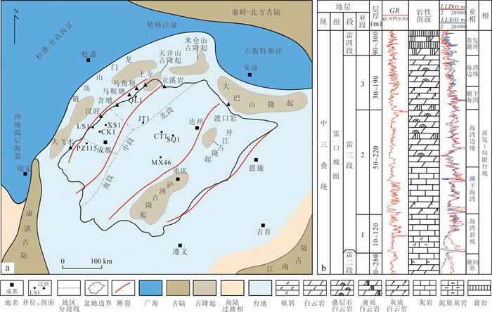
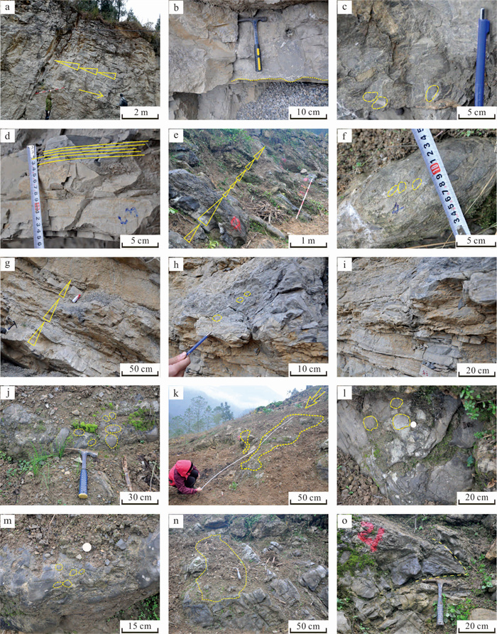
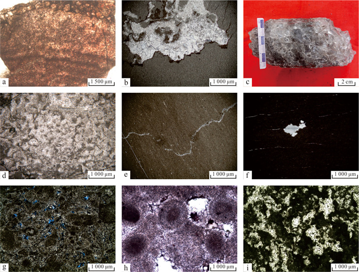
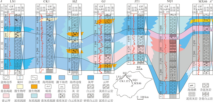
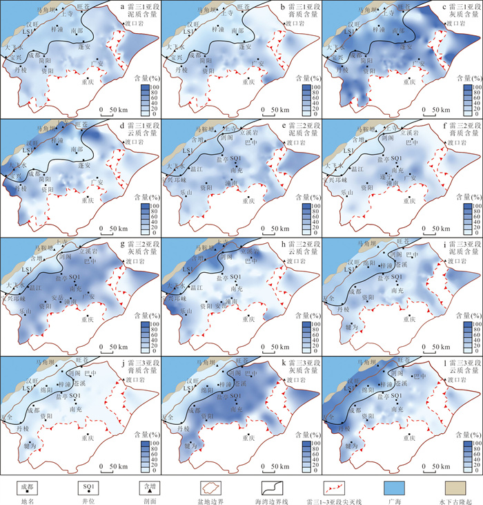
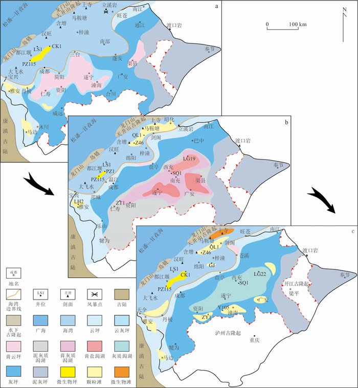
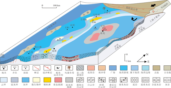
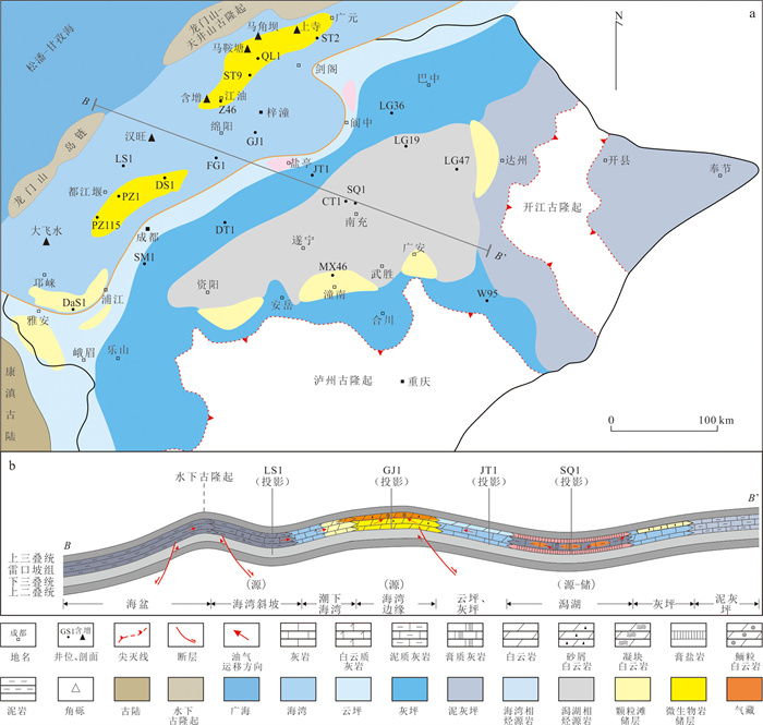
2026, 51(7): 2791-2806.
doi: 10.3799/dqkx.2026.162
Abstract:
The No. 8 coal seam in the Benxi Formation of the Yichuan Area on the southeastern margin of the Ordos Basin is extensively developed, serving as the primary target layer for coalbed methane exploration and development. To clarify the reservoir characteristics and peat-forming environment of this coal seam, experimental analyses were conducted based on core data from five wells, focusing on coal composition, pore structure characteristics, and elemental geochemistry. The macerals of the No. 8 coal are predominantly vitrinite, accounting for 80.5%. Proximate analysis indicates low moisture (0.94%), medium-low ash (13.29%), and low volatile matter content. The average random vitrinite reflectance is 2.99%, classifying it as high-rank anthracite. Among pore types, secondary organic gas pores are the most abundant, followed by intergranular pores and cellular pores. Well-developed micro-fractures significantly enhance the permeability of the coal matrix. Pore structure analysis reveals that the No. 8 coal is rich in micropores, which contribute 64.53% of the total pore volume, providing nearly all the storage space for adsorbed gas. Mesopores are underdeveloped, while macropores and micro-fractures are relatively well-developed, offering storage space for free gas. The main types of peat-forming swamps for the No. 8 coal were flooded forest swamps and deep-water reed swamps. The warm, humid paleoclimate favored the growth and proliferation of peat-forming plants, and the closed, reducing water environment promoted gelification, providing favorable conditions for the formation of high-quality coal.
The No. 8 coal seam in the Benxi Formation of the Yichuan Area on the southeastern margin of the Ordos Basin is extensively developed, serving as the primary target layer for coalbed methane exploration and development. To clarify the reservoir characteristics and peat-forming environment of this coal seam, experimental analyses were conducted based on core data from five wells, focusing on coal composition, pore structure characteristics, and elemental geochemistry. The macerals of the No. 8 coal are predominantly vitrinite, accounting for 80.5%. Proximate analysis indicates low moisture (0.94%), medium-low ash (13.29%), and low volatile matter content. The average random vitrinite reflectance is 2.99%, classifying it as high-rank anthracite. Among pore types, secondary organic gas pores are the most abundant, followed by intergranular pores and cellular pores. Well-developed micro-fractures significantly enhance the permeability of the coal matrix. Pore structure analysis reveals that the No. 8 coal is rich in micropores, which contribute 64.53% of the total pore volume, providing nearly all the storage space for adsorbed gas. Mesopores are underdeveloped, while macropores and micro-fractures are relatively well-developed, offering storage space for free gas. The main types of peat-forming swamps for the No. 8 coal were flooded forest swamps and deep-water reed swamps. The warm, humid paleoclimate favored the growth and proliferation of peat-forming plants, and the closed, reducing water environment promoted gelification, providing favorable conditions for the formation of high-quality coal.
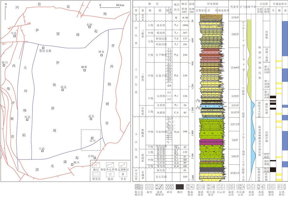
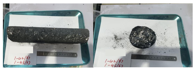
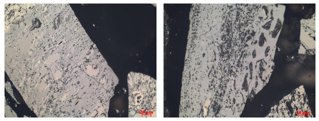
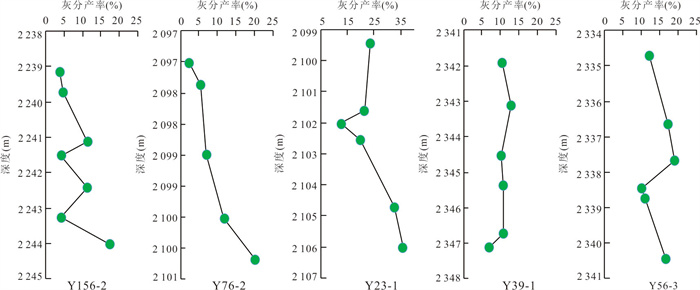
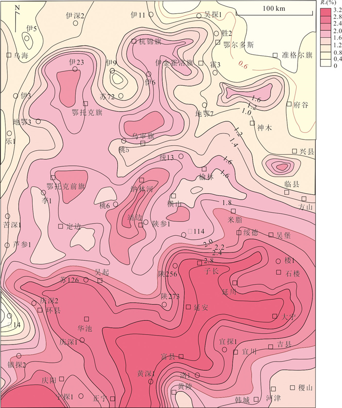
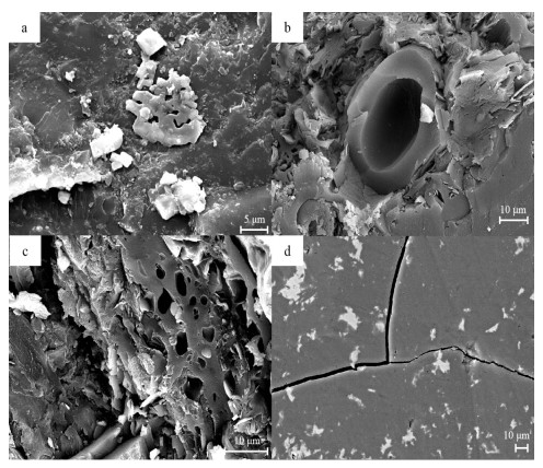
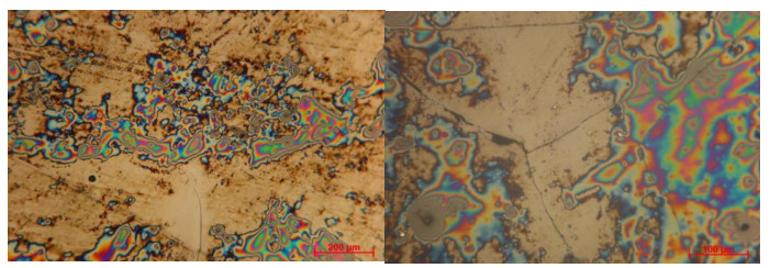
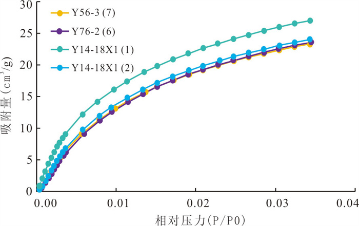
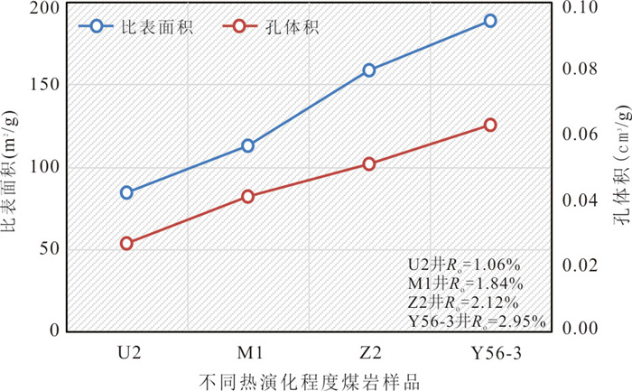
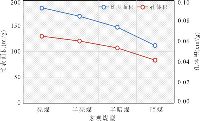
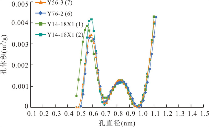
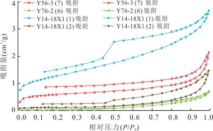
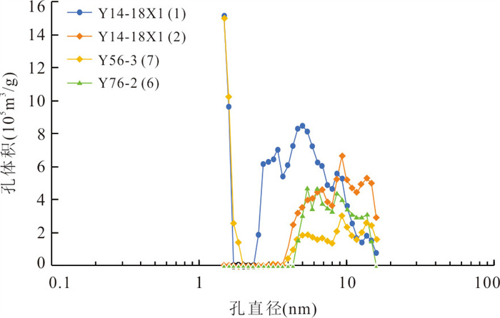
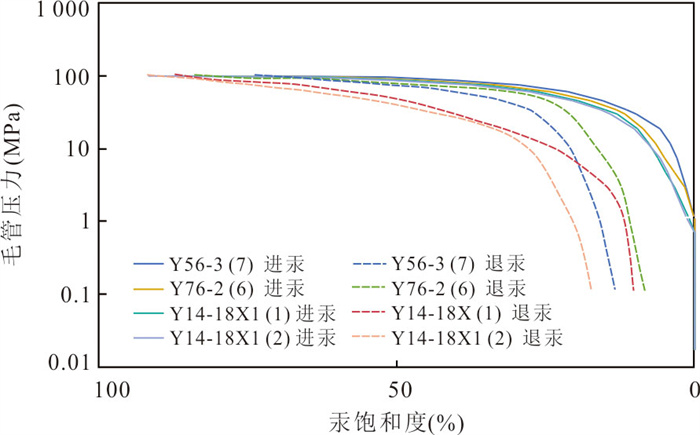
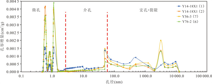
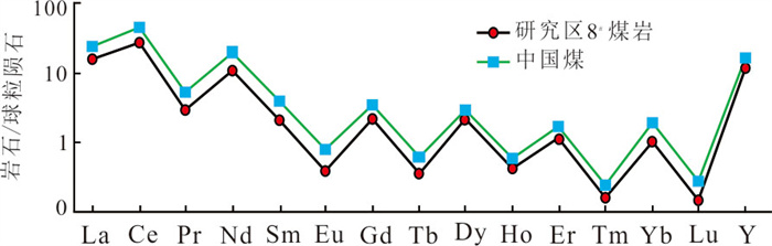
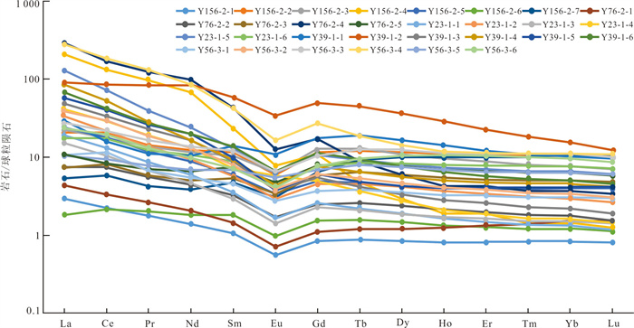
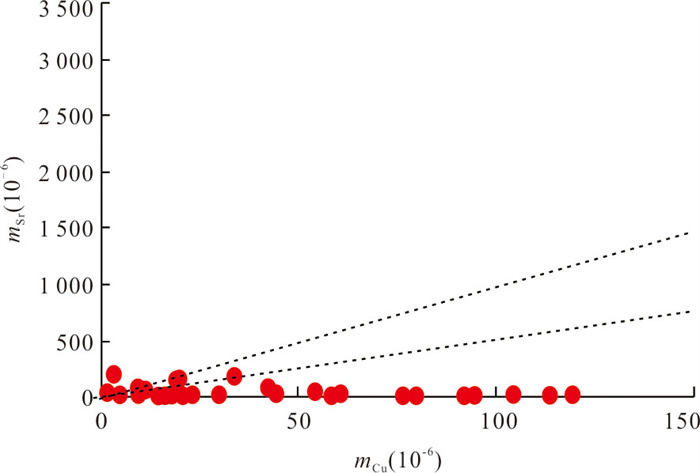
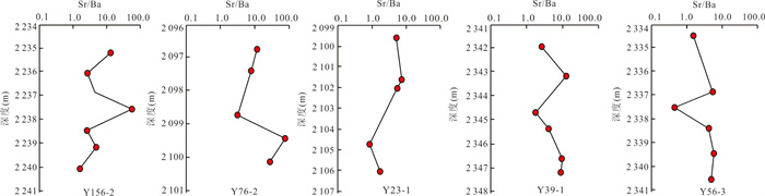
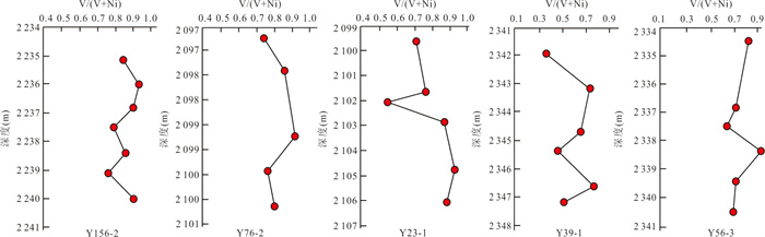
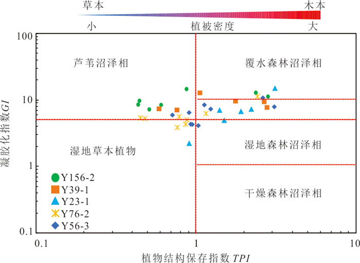
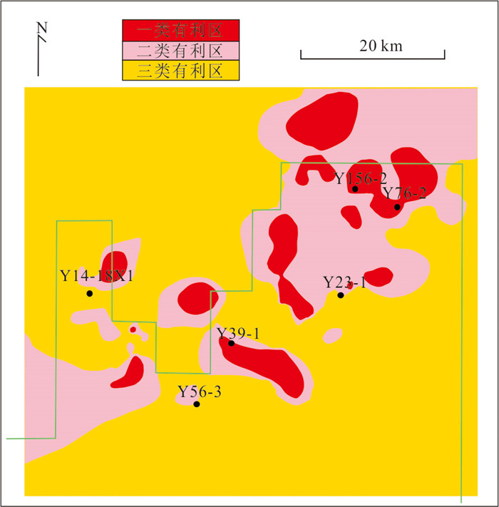
2026, 51(7): 2807-2820.
doi: 10.3799/dqkx.2026.223
Abstract:
The coal-rock gas represents a key domain of unconventional natural gas exploration and development in China. The flowback water generated during the coal-rock gas extraction is characterized by complex chemical compositions and poses potential risks to the aquatic environment. Therefore, investigating the geochemical characteristics and environmental risks of flowback water is of significant theoretical and practical importance for promoting the green development of the coal-rock gas and safeguarding regional water environment security. In this study, 80 flowback water samples were collected from 24 coal-rock gas wells in the eastern Ordos Basin. Systematic analyses of cations, anions, trace elements, hydrogen-oxygen isotopes and strontium isotopes were conducted to decipher the geochemical properties of the flowback fluids, reveal the genetic mechanism of the original formation water, evaluate potential environmental risks, and propose targeted treatment suggestions. The results show that the flowback water is characterized by high salinity and high total dissolved solids (TDS), with Cl-, Na+, Ca2+ and Sr2+ as the dominant ions. These samples are enriched in Ca and Sr but depleted in Mg, displaying higher total elemental concentrations than those of the flowback water from shale gas wells in the Sichuan Basin. It is concluded that the flowback water is a mixture of fracturing fluid and original formation water, and the original formation water in the study area is inferred to be of Cl-Ca type. The original formation water has undergone paleo-seawater evaporation and multiple types of water-rock interactions (including carbonate dissolution, dolomitization, clay mineral adsorption and mudstone dissolution), and exhibits significant spatial differentiation. The intense water-rock interactions recorded in the original formation water indicate that the reservoirs are tight and well-sealed, which is favorable for the generation and preservation of the coal-rock gas. Given that some toxic heavy metals in the flowback water exceed environmental discharge standards, we suggest establishing a disposal framework of "source-directed reuse, neutralization & salinity control, and full-domain management" to effectively mitigate environmental risks.
The coal-rock gas represents a key domain of unconventional natural gas exploration and development in China. The flowback water generated during the coal-rock gas extraction is characterized by complex chemical compositions and poses potential risks to the aquatic environment. Therefore, investigating the geochemical characteristics and environmental risks of flowback water is of significant theoretical and practical importance for promoting the green development of the coal-rock gas and safeguarding regional water environment security. In this study, 80 flowback water samples were collected from 24 coal-rock gas wells in the eastern Ordos Basin. Systematic analyses of cations, anions, trace elements, hydrogen-oxygen isotopes and strontium isotopes were conducted to decipher the geochemical properties of the flowback fluids, reveal the genetic mechanism of the original formation water, evaluate potential environmental risks, and propose targeted treatment suggestions. The results show that the flowback water is characterized by high salinity and high total dissolved solids (TDS), with Cl-, Na+, Ca2+ and Sr2+ as the dominant ions. These samples are enriched in Ca and Sr but depleted in Mg, displaying higher total elemental concentrations than those of the flowback water from shale gas wells in the Sichuan Basin. It is concluded that the flowback water is a mixture of fracturing fluid and original formation water, and the original formation water in the study area is inferred to be of Cl-Ca type. The original formation water has undergone paleo-seawater evaporation and multiple types of water-rock interactions (including carbonate dissolution, dolomitization, clay mineral adsorption and mudstone dissolution), and exhibits significant spatial differentiation. The intense water-rock interactions recorded in the original formation water indicate that the reservoirs are tight and well-sealed, which is favorable for the generation and preservation of the coal-rock gas. Given that some toxic heavy metals in the flowback water exceed environmental discharge standards, we suggest establishing a disposal framework of "source-directed reuse, neutralization & salinity control, and full-domain management" to effectively mitigate environmental risks.
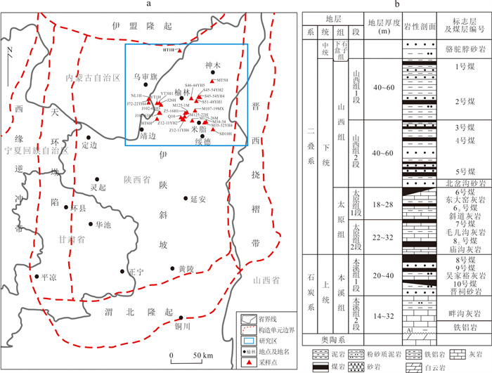
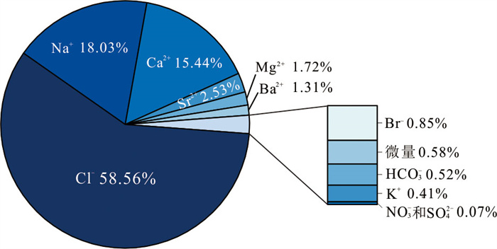
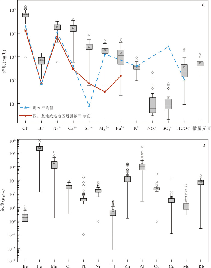
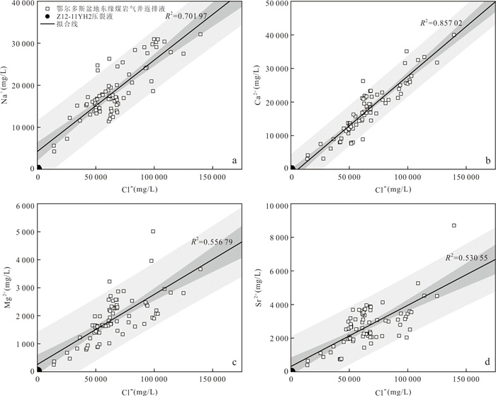
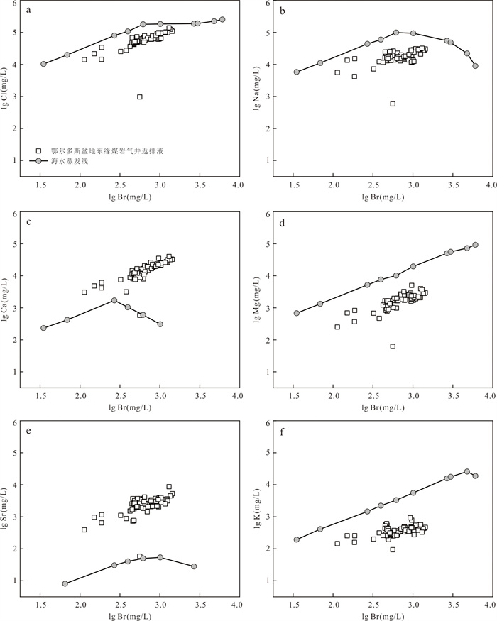
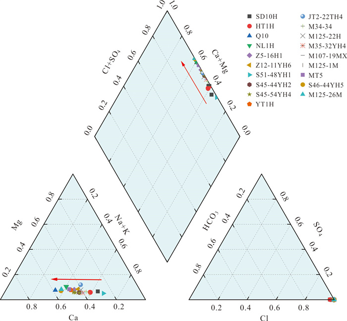
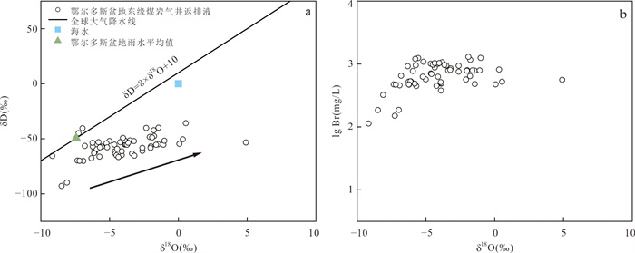
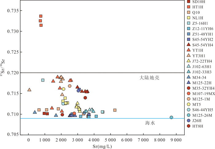
2026, 51(7): 2821-2837.
doi: 10.3799/dqkx.2026.177
Abstract:
The hydrocarbon occurrence mechanisms in continental shale strata oil reservoirs are highly complex, and the spatial configuration relationship between hydrocarbons and multi-scale, multi-type storage spaces constitutes a key scientific challenge that constrains sweet-spot prediction and efficient development. This study focuses on two representative lacustrine shale oil enrichment intervals: the Chang 7 Member in the Ordos Basin and the Kong 2 Member of the Cangdong Sag in the Bohai Bay Basin. By integrating petrological analysis, microstructural characterization, organic geochemical analysis, and fluid state testing, it systematically investigates hydrocarbon occurrence states and their coupling relationships with storage spaces under different source-reservoir configurations. The main findings are as follows. (1) In the "source-reservoir separated" interbedded sandstone reservoirs of Chang 71+2 Submember in Ordos Basin, hydrocarbons mainly exist in a "free state" in micrometer-sized inorganic pores, and the total enrichment is determined by the reservoir porosity. (2) In the "source-reservoir coexisting" mixed sedimentary shale reservoirs of Kong 2 Member in Bohai Bay Basin, hydrocarbons are mainly present in nano-micrometer-sized organic-inorganic composite pore systems, and hydrocarbons often exist in an "adsorbed state" in secondary organic pores formed by the secondary thermal cracking of migrated bitumen, and the enrichment degree is mainly controlled by the thermal maturity of organic matter. (3) In the "source-reservoir integrated" organic-rich shale reservoirs of Chang 73 Submember in Ordos Basin, there is a "swelling state" hydrocarbon occurrence mechanism within the shale kerogen, and the enrichment scale is mainly controlled by the total organic carbon content (TOC). (4) Throughout the "generation-expulsion-retention" process of shale oil, hydrocarbon occurrence evolves vertically from the core of source rocks outward into adjacent reservoirs following a continuous sequence: swollen-adsorbed-free-phase. Concurrently, the pore system transitions from nanometer-scale organic pores to micron-scale inorganic pores, forming a comprehensive geological process that spans from "in-situ retention" to "bulk migration" and from "nano-confinement" to "micro-scale mobility". The progressive understanding of hydrocarbon occurrence mechanisms in continental shale formations has provided a scientific basis for prioritizing exploration targets and designing development schemes across different reservoir types.
The hydrocarbon occurrence mechanisms in continental shale strata oil reservoirs are highly complex, and the spatial configuration relationship between hydrocarbons and multi-scale, multi-type storage spaces constitutes a key scientific challenge that constrains sweet-spot prediction and efficient development. This study focuses on two representative lacustrine shale oil enrichment intervals: the Chang 7 Member in the Ordos Basin and the Kong 2 Member of the Cangdong Sag in the Bohai Bay Basin. By integrating petrological analysis, microstructural characterization, organic geochemical analysis, and fluid state testing, it systematically investigates hydrocarbon occurrence states and their coupling relationships with storage spaces under different source-reservoir configurations. The main findings are as follows. (1) In the "source-reservoir separated" interbedded sandstone reservoirs of Chang 71+2 Submember in Ordos Basin, hydrocarbons mainly exist in a "free state" in micrometer-sized inorganic pores, and the total enrichment is determined by the reservoir porosity. (2) In the "source-reservoir coexisting" mixed sedimentary shale reservoirs of Kong 2 Member in Bohai Bay Basin, hydrocarbons are mainly present in nano-micrometer-sized organic-inorganic composite pore systems, and hydrocarbons often exist in an "adsorbed state" in secondary organic pores formed by the secondary thermal cracking of migrated bitumen, and the enrichment degree is mainly controlled by the thermal maturity of organic matter. (3) In the "source-reservoir integrated" organic-rich shale reservoirs of Chang 73 Submember in Ordos Basin, there is a "swelling state" hydrocarbon occurrence mechanism within the shale kerogen, and the enrichment scale is mainly controlled by the total organic carbon content (TOC). (4) Throughout the "generation-expulsion-retention" process of shale oil, hydrocarbon occurrence evolves vertically from the core of source rocks outward into adjacent reservoirs following a continuous sequence: swollen-adsorbed-free-phase. Concurrently, the pore system transitions from nanometer-scale organic pores to micron-scale inorganic pores, forming a comprehensive geological process that spans from "in-situ retention" to "bulk migration" and from "nano-confinement" to "micro-scale mobility". The progressive understanding of hydrocarbon occurrence mechanisms in continental shale formations has provided a scientific basis for prioritizing exploration targets and designing development schemes across different reservoir types.
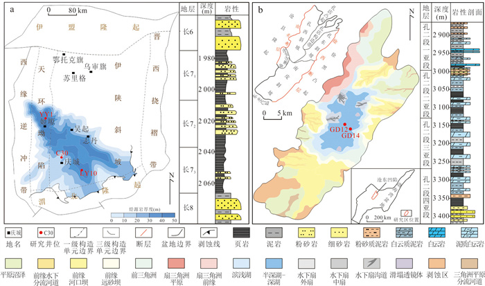
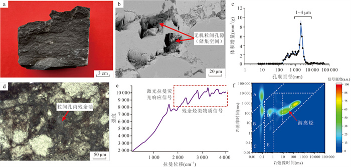
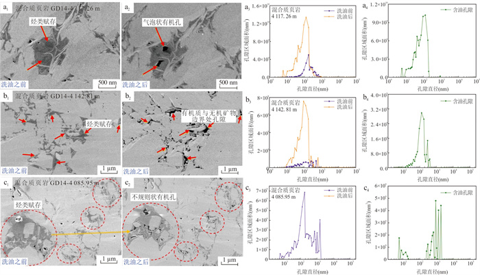
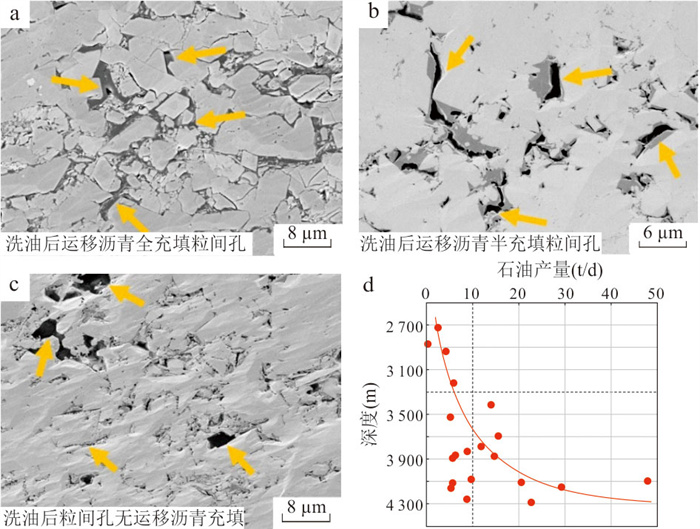
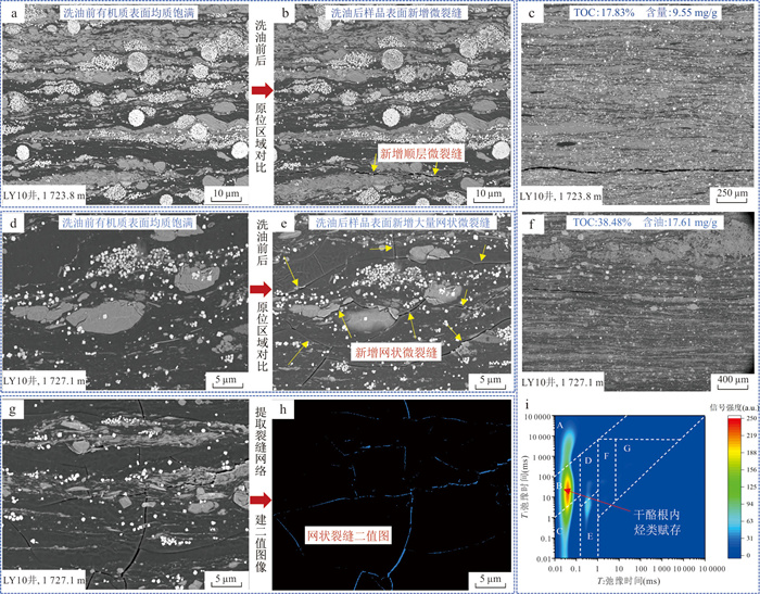
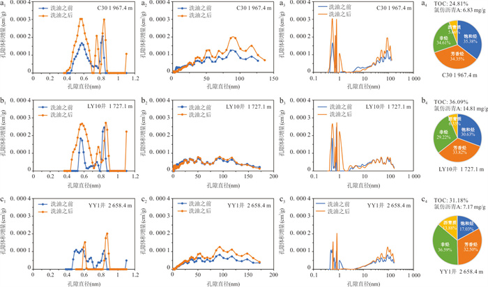
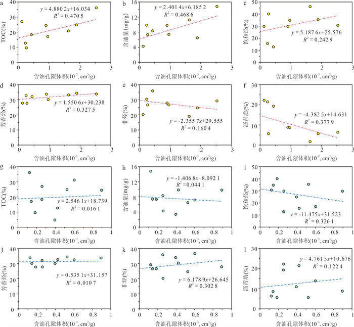
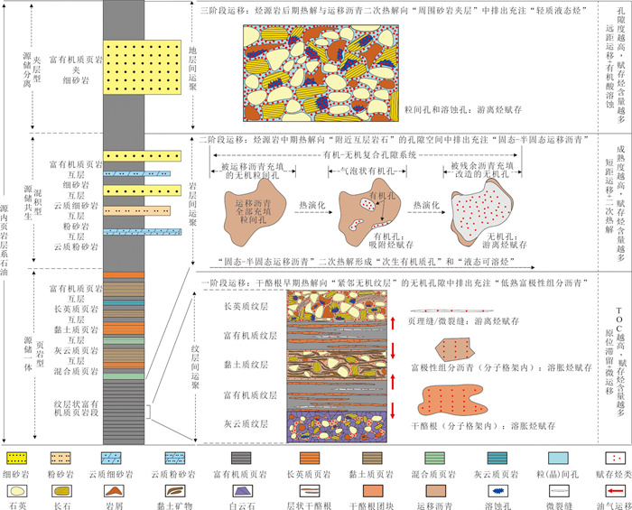
2026, 51(7): 2838-2853.
doi: 10.3799/dqkx.2026.161
Abstract:
Based on full-lifecycle big data from nearly 26 000 horizontal wells, and using mathematical statistics, random forest, and Pareto multi-objective optimization, this study reveals the synergistic evolution between engineering technologies and development performance in the Bakken shale play. Continuous iteration of engineering parameters extended the lateral length from 2 072 m to 3 553 m, increased proppant intensity from 0.29 t/m to 1.54 t/m, and reduced the drilling cycle to 50 d. As a result, the estimated ultimate recovery (EUR) per well doubled to 10.6×10⁴ t, while the drilling and fracturing cost per unit oil equivalent dropped from 89 USD/t to 45 USD/t, creating a significant "rising production, falling cost" beneficial scissors gap. Based on big-data patterns, we establish for the first time a "true vertical depth vs. water-to-vertical ratio" chart and a "true vertical depth vs. lateral length vs. proppant intensity" three-dimensional collaborative optimization chart, quantifying parameter adaptation intervals for deep, high-brittleness shale oil development. This study provides a quantifiable technical paradigm for China's continental shale oil to overcome development bottlenecks and transition from an experience-driven to a digital intelligence-driven approach.
Based on full-lifecycle big data from nearly 26 000 horizontal wells, and using mathematical statistics, random forest, and Pareto multi-objective optimization, this study reveals the synergistic evolution between engineering technologies and development performance in the Bakken shale play. Continuous iteration of engineering parameters extended the lateral length from 2 072 m to 3 553 m, increased proppant intensity from 0.29 t/m to 1.54 t/m, and reduced the drilling cycle to 50 d. As a result, the estimated ultimate recovery (EUR) per well doubled to 10.6×10⁴ t, while the drilling and fracturing cost per unit oil equivalent dropped from 89 USD/t to 45 USD/t, creating a significant "rising production, falling cost" beneficial scissors gap. Based on big-data patterns, we establish for the first time a "true vertical depth vs. water-to-vertical ratio" chart and a "true vertical depth vs. lateral length vs. proppant intensity" three-dimensional collaborative optimization chart, quantifying parameter adaptation intervals for deep, high-brittleness shale oil development. This study provides a quantifiable technical paradigm for China's continental shale oil to overcome development bottlenecks and transition from an experience-driven to a digital intelligence-driven approach.
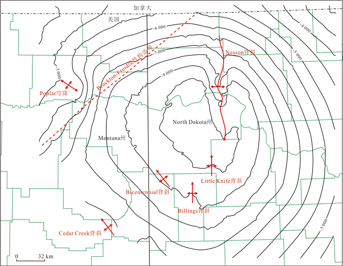
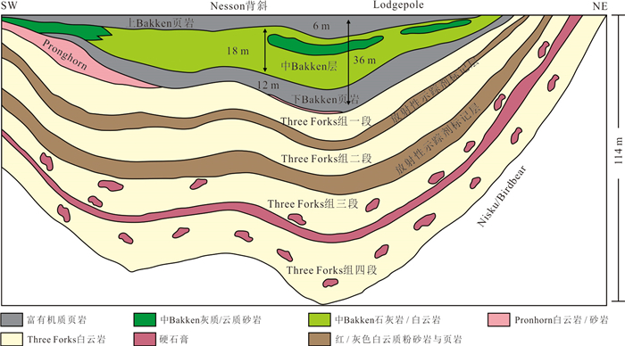
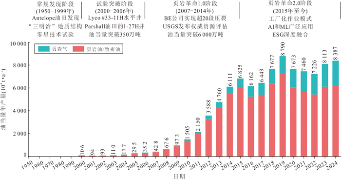
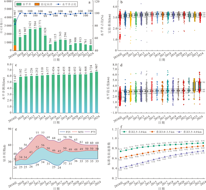
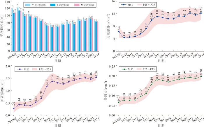
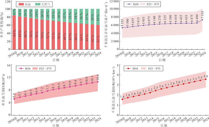
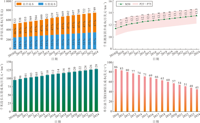
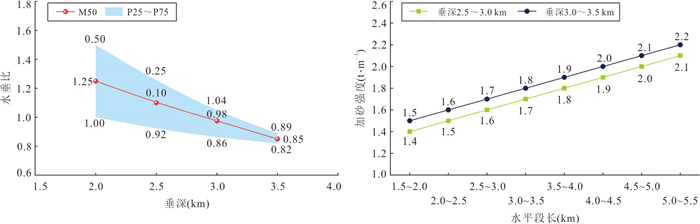
2026, 51(7): 2854-2868.
doi: 10.3799/dqkx.2026.148
Abstract:
Based on the results of oil and gas exploration practices and the commercial oil and gas field database in the Oman Basin, this study analyzes the formation background and hydrocarbon distribution patterns in the super basin using petroleum systems and plays as units. Research indicates that the Oman Basin has undergone multi-cycle tectonic movements since the Precambrian, but is primarily characterized by the development of a cratonic margin and a passive continental margin. The deposition was predominantly in shallow marine marginal environments, where continuous transgressive-regressive cycles formed dominant lithofacies associations of carbonate rocks+evaporite/mudstone. The efficient configuration of various petroleum system elements has resulted in five petroleum systems that are vertically stacked but do not interfere with each other. The distribution of oil and gas in the basin exhibits a regular and orderly pattern: spatially, it is distributed around salt basins and uplift zones, with the north being rich in both oil and gas, and the south being rich in oil; vertically, it is distributed around three major plays, with the lower sections rich in both oil and gas, and the upper sections rich in oil. The basin is rich in conventional oil and gas, shale oil and gas and helium, characterized by a three-dimensional accumulation of multi-layer and multi-type resources. The analysis concludes that the main controlling factors for hydrocarbon enrichment in the Oman Basin are: three major source kitchens serve as the material basis for hydrocarbon enrichment and orderly distribution; thick salt rocks within the salt basins and regionally stable mudstones control the vertical orderly enrichment of hydrocarbons; multi-phase fault systems and regional unconformities provide critical support for the three-dimensional migration of hydrocarbons/non-hydrocarbons and the formation of favorable traps.
Based on the results of oil and gas exploration practices and the commercial oil and gas field database in the Oman Basin, this study analyzes the formation background and hydrocarbon distribution patterns in the super basin using petroleum systems and plays as units. Research indicates that the Oman Basin has undergone multi-cycle tectonic movements since the Precambrian, but is primarily characterized by the development of a cratonic margin and a passive continental margin. The deposition was predominantly in shallow marine marginal environments, where continuous transgressive-regressive cycles formed dominant lithofacies associations of carbonate rocks+evaporite/mudstone. The efficient configuration of various petroleum system elements has resulted in five petroleum systems that are vertically stacked but do not interfere with each other. The distribution of oil and gas in the basin exhibits a regular and orderly pattern: spatially, it is distributed around salt basins and uplift zones, with the north being rich in both oil and gas, and the south being rich in oil; vertically, it is distributed around three major plays, with the lower sections rich in both oil and gas, and the upper sections rich in oil. The basin is rich in conventional oil and gas, shale oil and gas and helium, characterized by a three-dimensional accumulation of multi-layer and multi-type resources. The analysis concludes that the main controlling factors for hydrocarbon enrichment in the Oman Basin are: three major source kitchens serve as the material basis for hydrocarbon enrichment and orderly distribution; thick salt rocks within the salt basins and regionally stable mudstones control the vertical orderly enrichment of hydrocarbons; multi-phase fault systems and regional unconformities provide critical support for the three-dimensional migration of hydrocarbons/non-hydrocarbons and the formation of favorable traps.
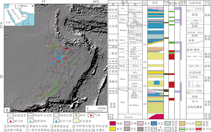
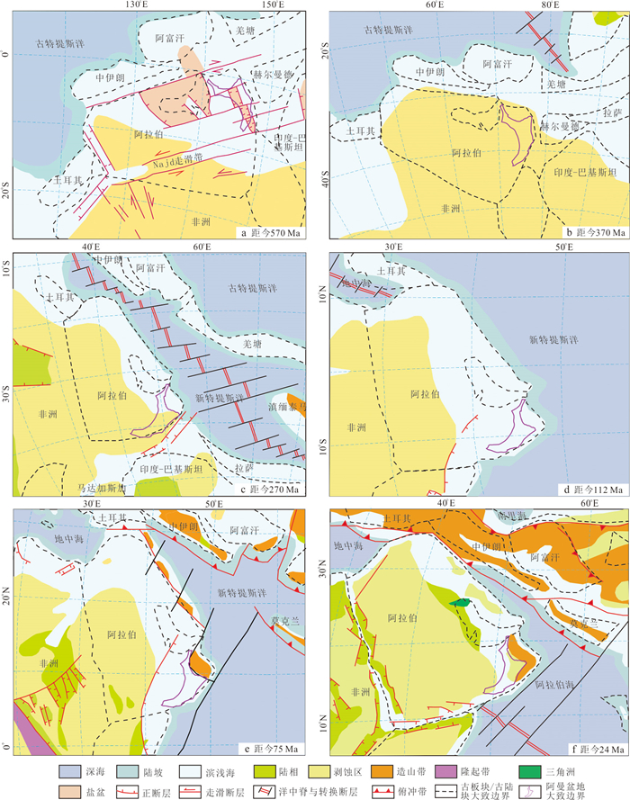
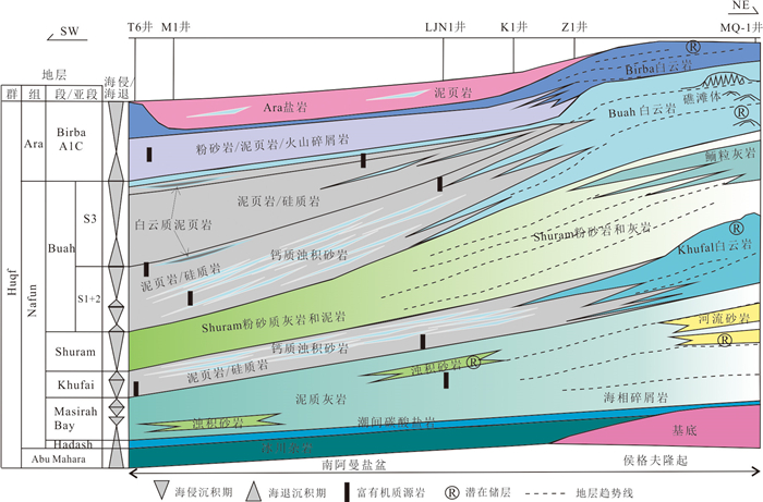
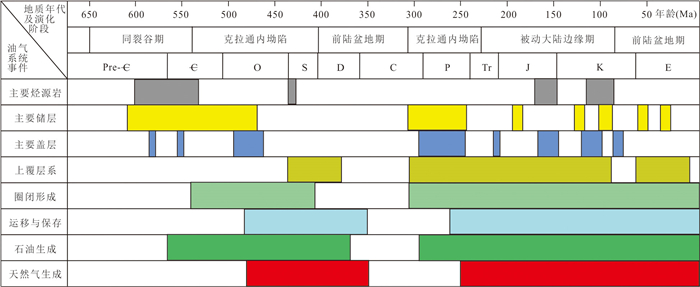
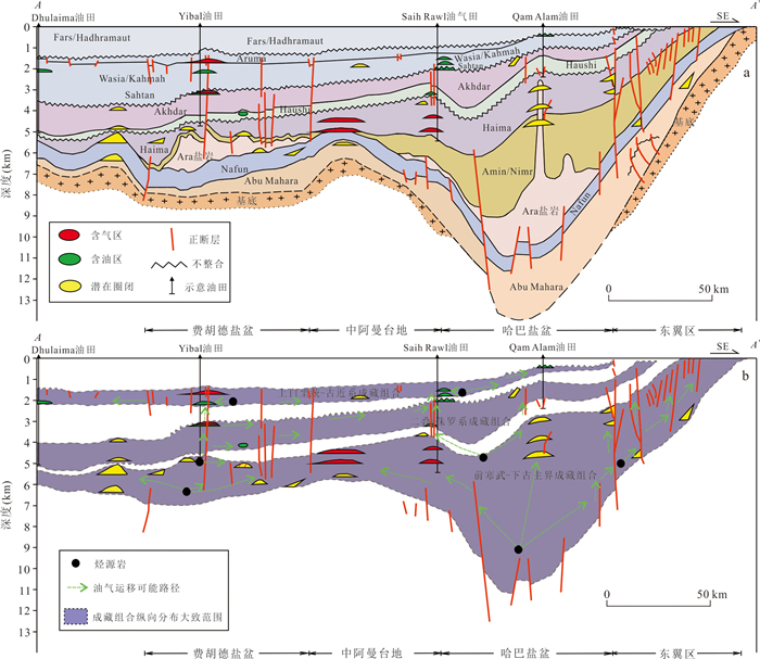
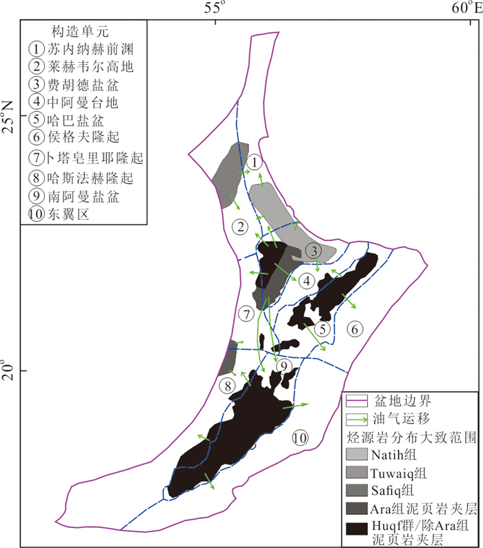
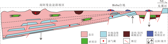
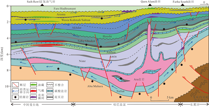
2026, 51(7): 2869-2893.
doi: 10.3799/dqkx.2026.194
Abstract:
Terrestrial wildfires are among the important driving forces in the evolution of global ecosystems. Studying paleowildfire events and their control mechanisms during key periods in geological history helps reveal the intrinsic connections between climatic and environmental evolution and wildfire activity. A total of 268 paleowildfire records reported worldwide, including records of charcoal, inertinite, and pyrogenic polycyclic aromatic hydrocarbons, were analyzed for the interval from Late Triassic to Early Jurassic (237-174.7 Ma). The study reveals that the spatial distribution of paleowildfires from the Carnian of the Late Triassic to the Norian-Rhaetian boundary was concentrated in tropical and warm-temperate zones at low to mid-latitudes in the Northern Hemisphere, with only a small number of Carnian paleowildfires distributed in the warm-temperate zone of the Southern Hemisphere. From the Rhaetian to the Rhaetian-Hettangian boundary (the Triassic-Jurassic/T-J boundary), paleowildfires were uniformly distributed across multiple climatic belts at mid-latitudes in the Northern Hemisphere. Wildfires in the Early Jurassic were concentrated in the warm-temperate and northern tropical zones at mid-latitudes in the Northern Hemisphere. Global paleowildfire activity from the Late Triassic to the Early Jurassic was controlled by combined effects of pCO2 (10-6; atmospheric CO2 concentration) and pO2 (vol%; atmospheric O2 volume fraction), vegetation change, and major geological events. The volcanic activity of the Wrangellia Large Igneous Province (LIP) in the Early Late Triassic promoted a rapid rise in pCO2. This rise, together with flourishing vegetation and high pO2, collectively drove the high frequency of wildfires during the Carnian. After pCO2 peaked in the Early Norian, it continued to decline, and this decline, together with the decrease in pO2, suppressed wildfire activity during the Norian. Subsequently, volcanic activity associated with the Angayucham LIP and the Central Atlantic Magmatic Province (CAMP) sequentially promoted the long-term recovery in pCO2 across Triassic-Jurassic (T-J) boundary. During this period, the structure of vegetation communities remained relatively stable, which contributed to an increase in wildfire frequency at the Norian-Rhaetian boundary, during the Rhaetian, at the Rhaetian-Hettangian boundary, and during the Hettangian. Negative carbon-isotope excursions recorded in multiple representative T-J boundary sections worldwide are interpreted as responses to the high-frequency wildfire events at the Rhaetian-Hettangian boundary, which were mainly driven by CAMP volcanism. With the continued decline in pO2 and climatic cooling during the Sinemurian, wildfire frequency dropped sharply. In the middle and late stages of the Early Jurassic, pCO2 generally remained at a low level. Only the recovery of pO2 during the Toarcian resulted in a slightly higher number of wildfires than in the Pliensbachian, while wildfire frequency remained almost unchanged.
Terrestrial wildfires are among the important driving forces in the evolution of global ecosystems. Studying paleowildfire events and their control mechanisms during key periods in geological history helps reveal the intrinsic connections between climatic and environmental evolution and wildfire activity. A total of 268 paleowildfire records reported worldwide, including records of charcoal, inertinite, and pyrogenic polycyclic aromatic hydrocarbons, were analyzed for the interval from Late Triassic to Early Jurassic (237-174.7 Ma). The study reveals that the spatial distribution of paleowildfires from the Carnian of the Late Triassic to the Norian-Rhaetian boundary was concentrated in tropical and warm-temperate zones at low to mid-latitudes in the Northern Hemisphere, with only a small number of Carnian paleowildfires distributed in the warm-temperate zone of the Southern Hemisphere. From the Rhaetian to the Rhaetian-Hettangian boundary (the Triassic-Jurassic/T-J boundary), paleowildfires were uniformly distributed across multiple climatic belts at mid-latitudes in the Northern Hemisphere. Wildfires in the Early Jurassic were concentrated in the warm-temperate and northern tropical zones at mid-latitudes in the Northern Hemisphere. Global paleowildfire activity from the Late Triassic to the Early Jurassic was controlled by combined effects of pCO2 (10-6; atmospheric CO2 concentration) and pO2 (vol%; atmospheric O2 volume fraction), vegetation change, and major geological events. The volcanic activity of the Wrangellia Large Igneous Province (LIP) in the Early Late Triassic promoted a rapid rise in pCO2. This rise, together with flourishing vegetation and high pO2, collectively drove the high frequency of wildfires during the Carnian. After pCO2 peaked in the Early Norian, it continued to decline, and this decline, together with the decrease in pO2, suppressed wildfire activity during the Norian. Subsequently, volcanic activity associated with the Angayucham LIP and the Central Atlantic Magmatic Province (CAMP) sequentially promoted the long-term recovery in pCO2 across Triassic-Jurassic (T-J) boundary. During this period, the structure of vegetation communities remained relatively stable, which contributed to an increase in wildfire frequency at the Norian-Rhaetian boundary, during the Rhaetian, at the Rhaetian-Hettangian boundary, and during the Hettangian. Negative carbon-isotope excursions recorded in multiple representative T-J boundary sections worldwide are interpreted as responses to the high-frequency wildfire events at the Rhaetian-Hettangian boundary, which were mainly driven by CAMP volcanism. With the continued decline in pO2 and climatic cooling during the Sinemurian, wildfire frequency dropped sharply. In the middle and late stages of the Early Jurassic, pCO2 generally remained at a low level. Only the recovery of pO2 during the Toarcian resulted in a slightly higher number of wildfires than in the Pliensbachian, while wildfire frequency remained almost unchanged.
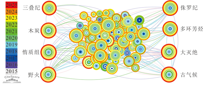
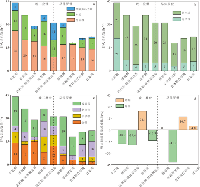
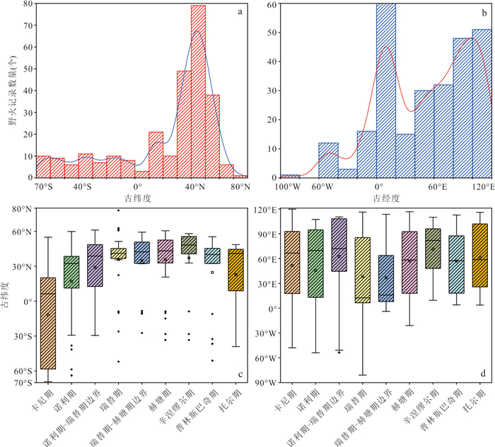
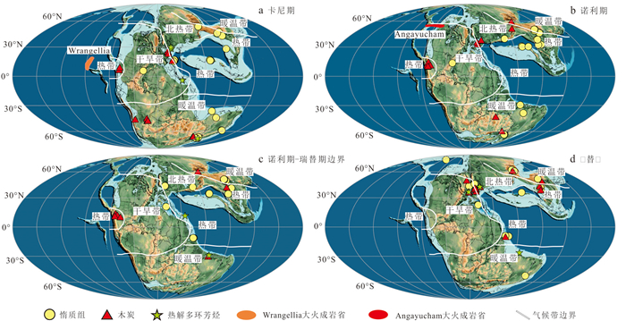
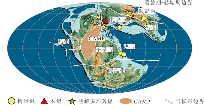
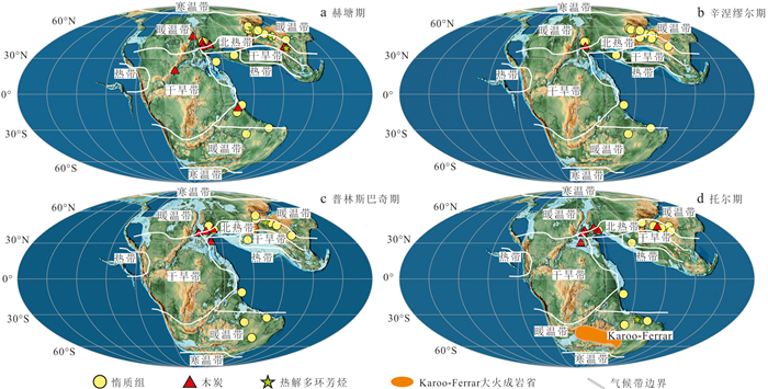
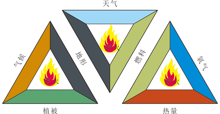
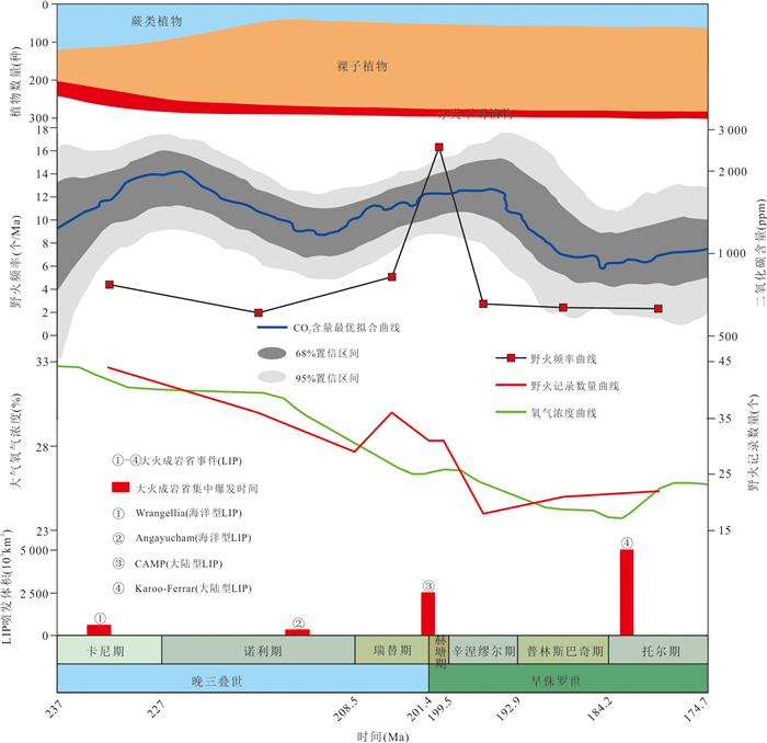
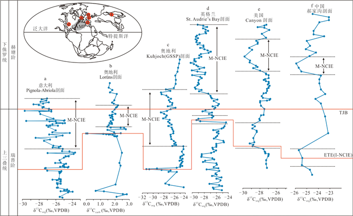
2026, 51(7): 2894-2914.
doi: 10.3799/dqkx.2026.073
Abstract:
The Permian-Triassic transition was characterized by severe climatic and environmental perturbations, accompanied by the largest mass extinction event in the Phanerozoic. The Siberian Traps Large Igneous Province, the largest continental large igneous province in Earth history, is widely considered to be the ultimate trigger of this ecological crisis. However, although sedimentary rocks preserve abundant environmental and biological signals, they generally lack direct records of volcanic activity, which has long hindered high-resolution investigations of the causal relationships among volcanism, environmental perturbations, and biotic crises during this interval. A critical challenge, therefore, lies in tracing signals of ancient volcanic activity within sedimentary successions. Taking the intense volcanism at the Permian-Triassic boundary as a representative case, this study reviews volcanic proxies preserved in stratigraphic records, including volcanic lava and ash (tuff) layers, volatile components (e.g., carbon, mercury, and sulfur), and non-volatile components (e.g., metallic elements such as copper, zinc, and nickel). The results indicate that these proxies exhibit pronounced signals saddle the Permian-Triassic boundary strata, suggesting that volcanic eruptions exerted significant impacts on surface elemental cycles. Furthermore, the advantages and limitations of different proxies are evaluated, providing a reference for future deep-time volcanic tracing studies and offering perspectives on future research directions.
The Permian-Triassic transition was characterized by severe climatic and environmental perturbations, accompanied by the largest mass extinction event in the Phanerozoic. The Siberian Traps Large Igneous Province, the largest continental large igneous province in Earth history, is widely considered to be the ultimate trigger of this ecological crisis. However, although sedimentary rocks preserve abundant environmental and biological signals, they generally lack direct records of volcanic activity, which has long hindered high-resolution investigations of the causal relationships among volcanism, environmental perturbations, and biotic crises during this interval. A critical challenge, therefore, lies in tracing signals of ancient volcanic activity within sedimentary successions. Taking the intense volcanism at the Permian-Triassic boundary as a representative case, this study reviews volcanic proxies preserved in stratigraphic records, including volcanic lava and ash (tuff) layers, volatile components (e.g., carbon, mercury, and sulfur), and non-volatile components (e.g., metallic elements such as copper, zinc, and nickel). The results indicate that these proxies exhibit pronounced signals saddle the Permian-Triassic boundary strata, suggesting that volcanic eruptions exerted significant impacts on surface elemental cycles. Furthermore, the advantages and limitations of different proxies are evaluated, providing a reference for future deep-time volcanic tracing studies and offering perspectives on future research directions.
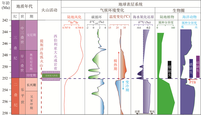
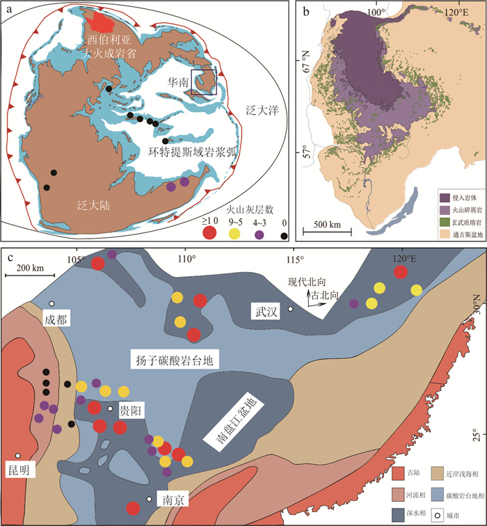
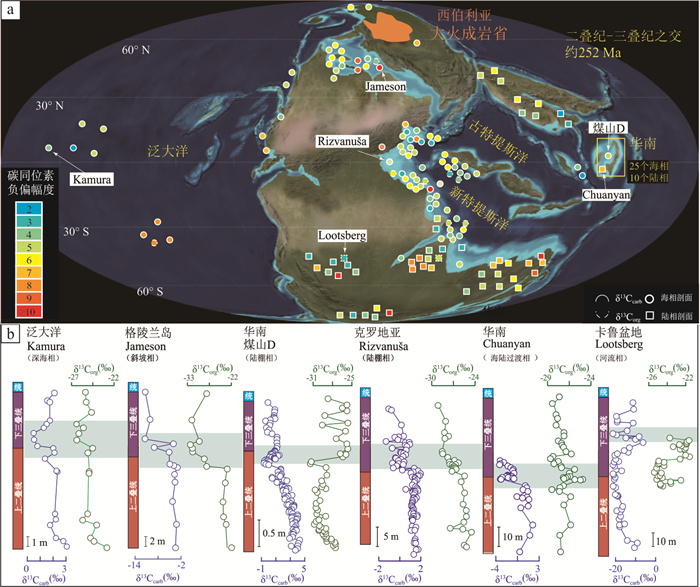
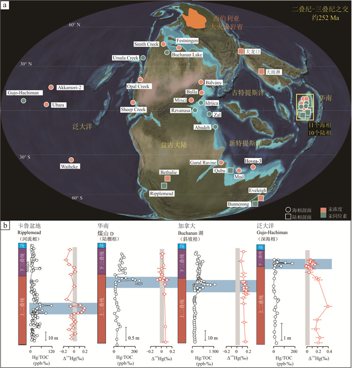
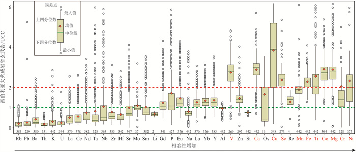
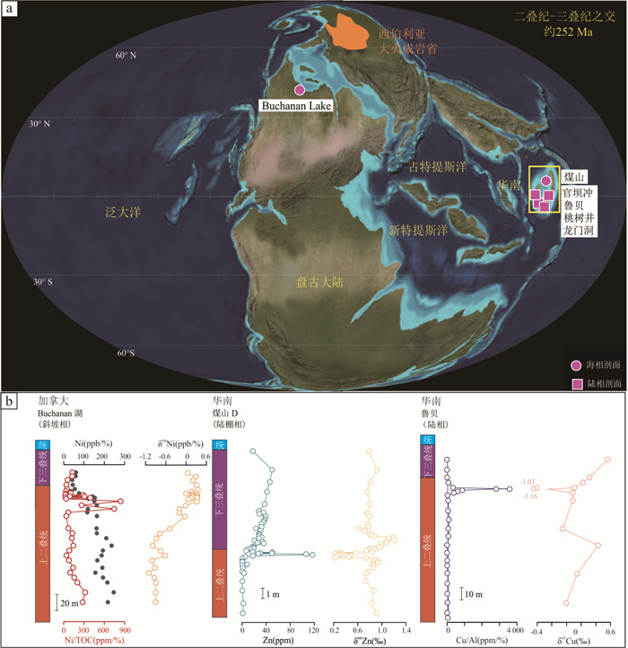
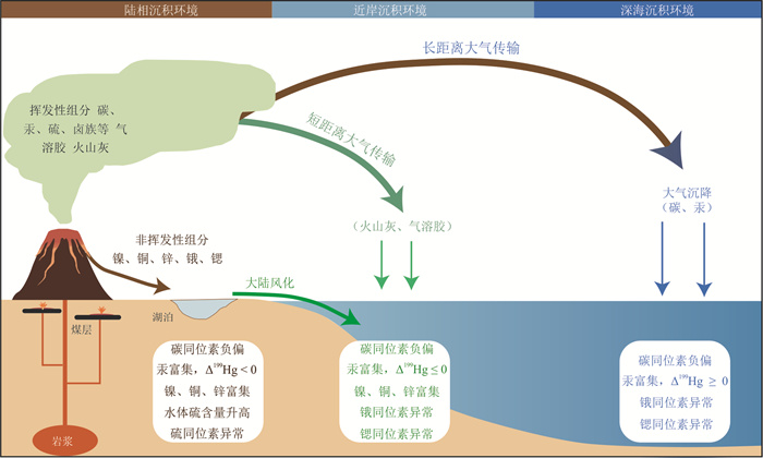
2026, 51(7): 2915-2926.
doi: 10.3799/dqkx.2026.118
Abstract:
Geological samples beneath the Antarctic ice and in the Southern Ocean are crucial for understanding the evolution of the Antarctic geology, the stability of the Antarctic ice sheet and the influence mechanisms of the Southern Ocean on global climate and environment. Scientific drilling is the only technical means to obtain such samples. In recent years, the United States has developed a series of scientific drilling equipment and tools for drilling beneath the Antarctic ice and in the Southern Ocean, and has carried out a large number of scientific drilling projects. Although China has also carried out the research and development of drilling equipment for subglacial bedrock coring and successfully applied it in Antarctica, there is still a considerable gap compared with the United States. This paper systematically reviews the drilling technologies and projects at home and abroad involved in drilling beneath the Antarctic ice, beneath the ice shelves, and in the Southern Ocean, and proposes development suggestions for scientific drilling beneath the Antarctic ice and in the Southern Ocean that are suitable for China's national conditions with the aim of providing a reference for the formulation of China's polar science and technology plans.
Geological samples beneath the Antarctic ice and in the Southern Ocean are crucial for understanding the evolution of the Antarctic geology, the stability of the Antarctic ice sheet and the influence mechanisms of the Southern Ocean on global climate and environment. Scientific drilling is the only technical means to obtain such samples. In recent years, the United States has developed a series of scientific drilling equipment and tools for drilling beneath the Antarctic ice and in the Southern Ocean, and has carried out a large number of scientific drilling projects. Although China has also carried out the research and development of drilling equipment for subglacial bedrock coring and successfully applied it in Antarctica, there is still a considerable gap compared with the United States. This paper systematically reviews the drilling technologies and projects at home and abroad involved in drilling beneath the Antarctic ice, beneath the ice shelves, and in the Southern Ocean, and proposes development suggestions for scientific drilling beneath the Antarctic ice and in the Southern Ocean that are suitable for China's national conditions with the aim of providing a reference for the formulation of China's polar science and technology plans.