- 中文版:
- EI 100%收录
- 英文版
- SCI 100%收录


中国出版政府奖提名奖
中国百强科技报刊
湖北出版政府奖
中国高校百佳科技期刊
中国最美期刊
中国出版政府奖提名奖
中国百强科技报刊
湖北出版政府奖
中国高校百佳科技期刊
中国最美期刊
| Citation: | Yuan Xinxia, Guo Changbao, Yan Yiqiu, Li Caihong, Liu Gui, Jian Wenxing, 2026. Landslide Hazard Assessment in Alpine Gorge Region Based on Slope Units and SBAS-InSAR Surface Deformation Velocity: A Case Study of Diwu Township Section in Upper Reaches of Jinsha River. Earth Science, 51(4): 1371-1387. doi: 10.3799/dqkx.2025.146

|
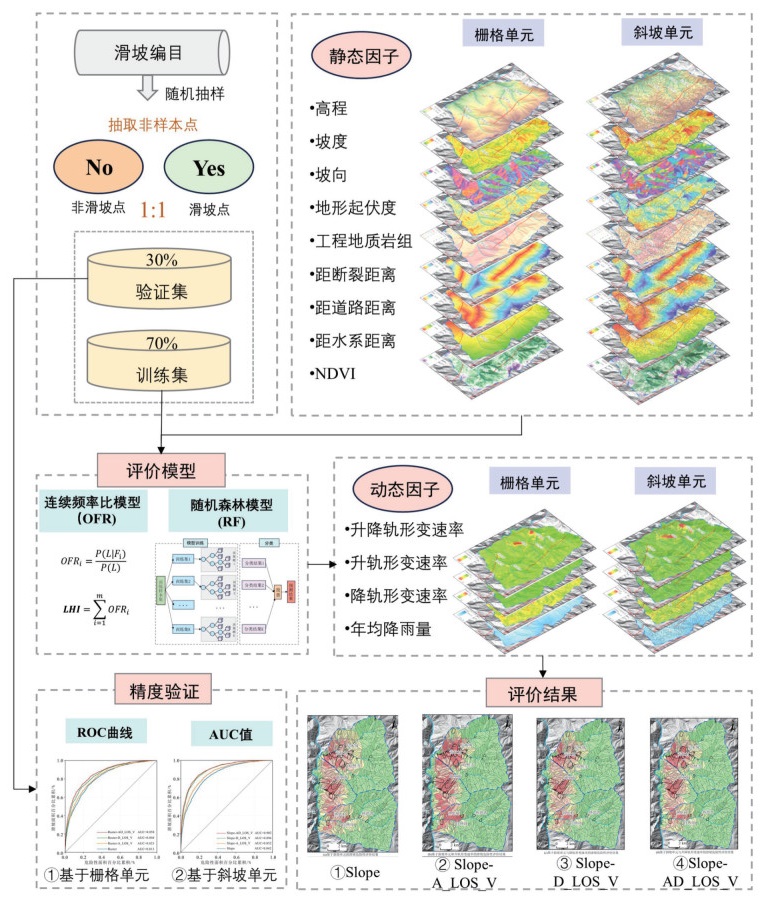
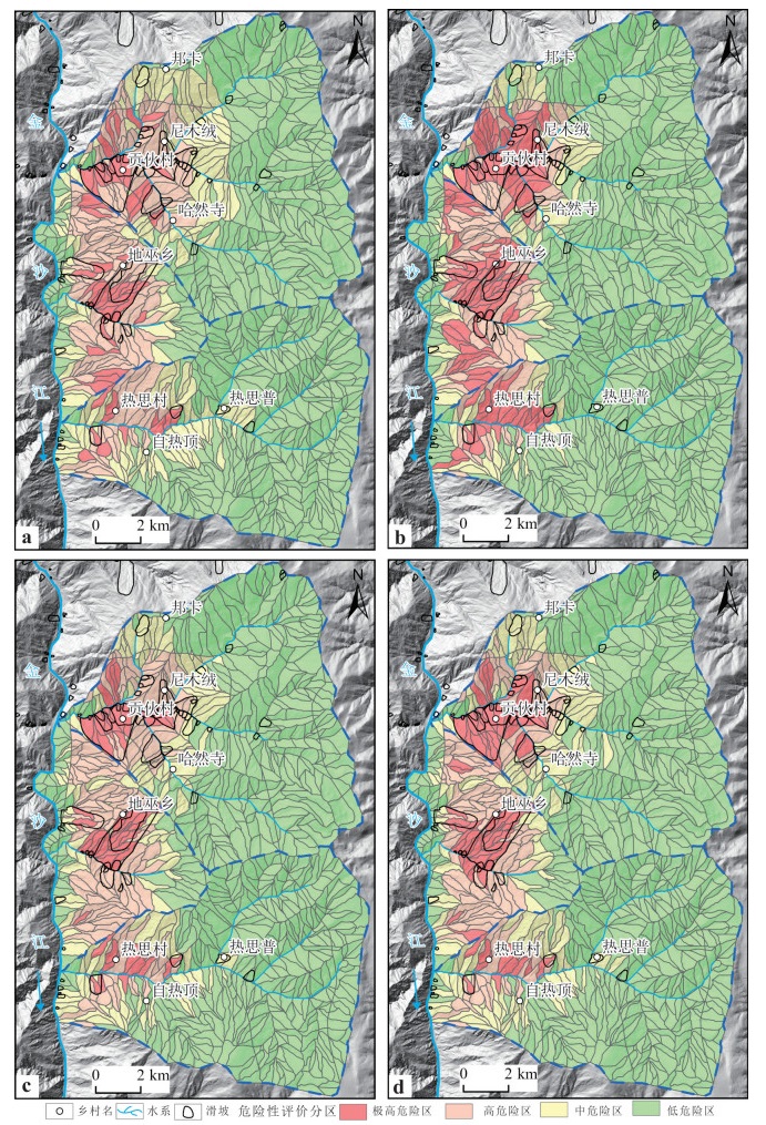
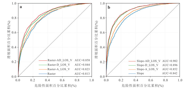
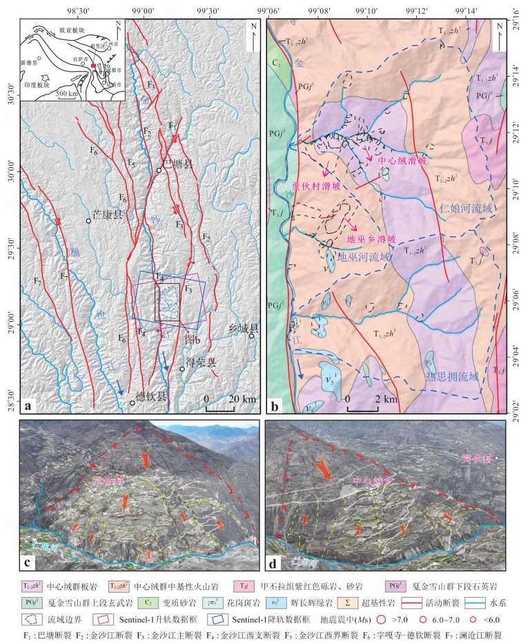
The upper reaches of the Jinsha River, located on the eastern margin of Tibet Plateau, is characterized by intense tectonic activity and frequent landslide disasters in alpine gorge region. However, current landslide hazard assessment models demonstrate limited predictive accuracy, failing to meet the precision requirements for practical disaster prevention and mitigation efforts. This study focuses on the Diwu Township Section in the upper reaches of Jinsha River. Through the integration of remote sensing interpretation and field geological surveys, and based on the regional characteristics of landslide development, it refined the hydrological analysis method to delineate slope units guided by a watershed–geomorphology–slope structure framework. Thirteen evaluation factors were selected, including topographic and geomorphological indicators (elevation, slope, aspect, and terrain relief), lithology, active faults, rainfall, hydrographic network, anthropogenic engineering activities, vegetation coverage, and SBAS-InSAR surface deformation velocity. A novel random forest-continuous frequency ratio (RF-OFR) model was employed to conduct regional landslide hazard assessment. Results demonstrate that slope unit-based evaluation achieves significantly higher accuracy (AUC=0.902) compared to grid unit analysis (AUC=0.858), with delineated high-risk zones showing strong spatial correspondence with documented landslide occurrences. Moreover, within the slope unit framework, the combined ascending and descending SBAS-InSAR deformation results yielded the highest predictive accuracy (AUC=0.902), representing improvements of 6%, 5%, and 0.6% over models using no deformation input, ascending-only, and descending-only data, while significantly improving detection capability for hidden creeping landslides. These findings provide enhanced scientific support for landslide hazard assessment in alpine gorge region and offer valuable references for regional geohazard prevention and risk management strategies.

|
Alvioli, M., Marchesini, I., Reichenbach, P., et al., 2016. Automatic Delineation of Geomorphological Slope Units with R. slopeunits V1.0 and Their Optimization for Landslide Susceptibility Modeling. Geoscientific Model Development, 9(11): 3975-3991. https://doi.org/10.5194/gmd-9-3975-2016
|
|
Bui, D. T., Tuan, T. A., Klempe, H., et al., 2016. Spatial Prediction Models for Shallow Landslide Hazards: A Comparative Assessment of the Efficacy of Support Vector Machines, Artificial Neural Networks, Kernel Logistic Regression, and Logistic Model Tree. Landslides, 13(2): 361-378. https://doi.org/10.1007/s10346-015-0557-6
|
|
Cao, P., Tang, H. M., Wang, M., et al., 2025. Exploring the Failure Mechanism of the Baige Landslide via Field Observations and Physical Model Tests. Journal of Earth Science, 36(4): 1682-1699. https://doi.org/10.1007/s12583-025-0267-5
|
|
Chang, Y. Q., Chen, L. C., Zhang, Q., 2019. Analysis of Tectonic Geomorphology and Activity Characteristics of the Jinsha River Fault. Recent Developments in World Seismology, 49(8): 142-143 (in Chinese with English abstract).
|
|
Chen, Z., Ye, F., Fu, W. X., et al., 2020. The Influence of DEM Spatial Resolution on Landslide Susceptibility Mapping in the Baxie River Basin, NW China. Natural Hazards, 101(3): 853-877. https://doi.org/10.1007/s11069-020-03899-9
|
|
Du, J., Yang, Q. H., Yan, J., et al., 2010. Hazard Evaluation of Secondary Geological Disaster Based on GIS and Information Value Method. Earth Science, 35(2): 324-330 (in Chinese with English abstract).
|
|
Feng, H. J., Zhou, A. G., Yu, J. J., et al., 2016. A Comparative Study on Plum-Rain-Triggered Landslide Susceptibility Assessment Models in West Zhejiang Province. Earth Science, 41(3): 403-415 (in Chinese with English abstract).
|
|
Fruneau, B., Achache, J., Delacourt, C., 1996. Observation and Modelling of the Saint-Étienne-de-Tinée Landslide Using SAR Interferometry. Tectonophysics, 265(3-4): 181-190. https://doi.org/10.1016/S0040-1951(96)00047-9
|
|
Ge, D. Q., Wang, Y., Fan, J. H., et al., 2007. A Study of Surface Deformation Monitoring Using Differential SAR Interferometry Technique and an Analysis of Its Key Problems. Remote Sensing for Land & Resources, 19(4): 14-22 (in Chinese with English abstract).
|
|
Guo, C. B., Qiu, Z. D., Yan, Y. Q., et al., 2025. Research on Spatial Structural Characteristics of Large Deep-Seated Landslide Based on High-Density Electrical Resistivity and Microtremor Detection: A Case Study of the Diwuxiang Landslide in Batang County, Tibetan Plateau, China. Geomatics and Information Science of Wuhan University: 1-20 (in Press) (in Chinese with English abstract).
|
|
He, J. Y., Ju, N. P., Xie, M. L., et al., 2023. Comparison of InSAR Technology for Identification of Hidden Dangers of Geological Hazards in Alpine and Canyon Areas. Earth Science, 48(11): 4295-4310 (in Chinese with English abstract).
|
|
Huang, X. C., Yu, T. B., Wang, M., et al., 2021. Remote Sensing Dynamic Analysis of Chain Characteristics of Long Range and High Position Landslide in Jinsha River Junction Zone: A Case Study of Baige Landslide. The Chinese Journal of Geological Hazard and Control, 32(5): 40-51 (in Chinese with English abstract).
|
|
Jiao, W. Z., Zhang, M., Xie, X. P., et al., 2022. Susceptibility Evaluation of Urban Geological Disaster Based on GIS and Weighted Information Value Model: A Case Study of Daxin Town. Safety and Environmental Engineering, 29(4): 119-128 (in Chinese with English abstract).
|
|
Li, L. P., Lan, H. X., Guo, C. B., et al., 2017. A Modified Frequency Ratio Method for Landslide Susceptibility Assessment. Landslides, 14(2): 727-741. https://doi.org/10.1007/s10346-016-0771-x
|
|
Li, L. P., Lan, H. X., Li, L. P., et al., 2023. Bivariate Landslide Susceptibility Analysis: Clarification, Optimization, Open Software, and Preliminary Comparison. Remote Sensing, 15(5): 1418. https://doi.org/10.3390/rs15051418
|
|
Li, Y., Wu, R. Z., Zhu, L. D., et al., 2000. Discovery of Late Paleozoic Conodonts in the Western Segment of Jinshajiang Fault Zone in Xizang and Its Geological Significance. Earth Science, 25(6): 586-616 (in Chinese with English abstract).
|
|
Liu, C. L., Qi, S. W., Tong, L. Q., et al., 2010. Great Landslides in Himalaya Mountain Area and Their Occurrence with Lithology. Journal of Engineering Geology, 18(5): 669-676 (in Chinese with English abstract).
|
|
Meng, T., Xu, X. L., Liu, H. H., 2021. Landslide Risk Assessment in High Altitude Areas Based on Slope Unit Optimization: Taking the Baige Landslide in Jinsha River as an Example. Journal of Henan Polytechnic University (Natural Science), 40(1): 65-73 (in Chinese with English abstract).
|
|
Mondal, S., Maiti, R., 2013. Integrating the Analytical Hierarchy Process (AHP) and the Frequency Ratio (FR) Model in Landslide Susceptibility Mapping of Shiv-Khola Watershed, Darjeeling Himalaya. International Journal of Disaster Risk Science, 4(4): 200-212. https://doi.org/10.1007/s13753-013-0021-y
|
|
Niu, R. Q., Peng, L., Ye, R. Q., et al., 2012. Landslide Susceptibility Assessment Based on Rough Sets and Support Vector Machine. Journal of Jilin University (Earth Science Edition), 42(2): 430-439 (in Chinese with English abstract).
|
|
Notti, D., Davalillo, J. C., Herrera, G., et al., 2010. Assessment of the Performance of X-Band Satellite Radar Data for Landslide Mapping and Monitoring: Upper Tena Valley Case Study. Natural Hazards and Earth System Sciences, 10(9): 1865-1875. https://doi.org/10.5194/nhess-10-1865-2010
|
|
Notti, D., Galve, J. P., Mateos, R. M., et al., 2015. Human-Induced Coastal Landslide Reactivation. Monitoring by PSInSAR Techniques and Urban Damage Survey (SE Spain). Landslides, 12(5): 1007-1014. https://doi.org/10.1007/s10346-015-0612-3
|
|
Peng, J. B., Ma, R. Y., Lu, Q. Z., et al., 2004. Geological Hazards Effects of Uplift of Qinghai-Tibet Plateau. Advance in Earth Sciences, 19(3): 457-466 (in Chinese with English abstract).
|
|
Ren, S. S., Guo, C. B., Zhang, Y. S., et al., 2017. Development Characteristics and Formation Mechanism of Chashushan Landslide in Batang, Western Sichuan. Geoscience, 31(5): 978-989 (in Chinese with English abstract).
|
|
Shan, Y. F., Xu, Z., Zhou, S. S., et al., 2023. Landslide Hazard Assessment Combined with InSAR Deformation: A Case Study in the Zagunao River Basin, Sichuan Province, Southwestern China. Remote Sensing, 16(1): 99. https://doi.org/10.3390/rs16010099
|
|
Shano, L., Raghuvanshi, T. K., Meten, M., 2020. Landslide Susceptibility Evaluation and Hazard Zonation Techniques—A Review. Geoenvironmental Disasters, 7(1): 18. https://doi.org/10.1186/s40677-020-00152-0
|
|
Silalahi, F. E. S., Pamela, Arifianti, Y., et al., 2019. Landslide Susceptibility Assessment Using Frequency Ratio Model in Bogor, West Java, Indonesia. Geoscience Letters, 6(1): 10. https://doi.org/10.1186/s40562-019-0140-4
|
|
Wang, K., Zhang, S. J., DelgadoTéllez, R., et al., 2019. A New Slope Unit Extraction Method for Regional Landslide Analysis Based on Morphological Image Analysis. Bulletin of Engineering Geology and the Environment, 78(6): 4139-4151. https://doi.org/10.1007/s10064-018-1389-0
|
|
Xi, W. F., Cheng, X., Yang, Z. Q., et al., 2024. Research on High-Altitude and Long-Distance Landslide Risk Analysis Based on the Combination of SBAS-InSAR Technology and BP Neural Network. Journal of Kunming University of Science and Technology (Natural Science), 49(3): 65-74 (in Chinese with English abstract).
|
|
Xia, J. W., Zhu, M., 2020. Study on Tectonic Characteristics and Activity of Middle Section of Jinshajiang Main Fault Zone. Yangtze River, 51(5): 131-137, 159 (in Chinese with English abstract).
|
|
Xiao, T., Liu, Q. L., Deng, M., et al., 2025. Evolution Patterns of Landslide Susceptibility in Three Gorges Reservoir Areas. Earth Science, 50(4): 1625-1637 (in Chinese with English abstract).
|
|
Xie, M. W., Esaki, T., Zhou, G. Y., 2004. GIS-Based Probabilistic Mapping of Landslide Hazard Using a Three-Dimensional Deterministic Model. Natural Hazards, 33(2): 265-282. https://doi.org/10.1023/B:NHAZ.0000037036.01850.0d
|
|
Xu, X. W., Zhang, P. Z., Wen, X. Z., et al., 2005. Features of Active Tectonics and Recurrence Behaviors of Strong Earthquakes in the Western Sichuan Province and Its Adjacent Regions. Seismology and Geology, 27(3): 446-461 (in Chinese with English abstract).
|
|
Xu, Z. W., Luo, Y. Z., 2002. The Forming Cause and the Stability Analyze of the Landslide in Huale Village, Fengjie County, the City of Chongqing. Journal of Geological Hazards and Environment Preservation, 13(1): 29-32, 47 (in Chinese with English abstract).
|
|
Yan, G., Liang, S. Y., Zhao, H. L., 2017. An Approach to Improving Slope Unit Division Using GIS Technique. Scientia Geographica Sinica, 37(11): 1764-1770 (in Chinese with English abstract).
|
|
Yan, Y. Q., Guo, C. B., Zhong, N., et al., 2022. Deformation Characteristics of Jiaju Ancient Landslide Based on InSAR Monitoring Method, Sichuan, China. Earth Science, 47(12): 4681-4697 (in Chinese with English abstract).
|
|
Yan, Y. Q., Yang, Z. H., Zhang, X. J., et al., 2021. Landslide Susceptibility Assessment Based on Weight-of-Evidence Modeling of the Batang Fault Zone, Eastern Tibetan Plateau. Geoscience, 35(1): 26-37 (in Chinese with English abstract).
|
|
Yin, Y. P., Wang, W. P., Zhang, N., et al., 2017. Long Runout Geological Disaster Initiated by the Ridge-Top Rockslide in a Strong Earthquake Area: A Case Study of the Xinmo Landslide in Maoxian County, Sichuan Province. Geology in China, 44(5): 827-841 (in Chinese with English abstract).
|
|
Yuan, H., Guo, C. B., Wu, R. A., et al., 2024. Shear Strength Characteristics of Sliding Zone Soils and Mechanisms of Luanshibao Long Runout Landslide in Litang County, Sichuan Province, China. Earth Science, 49(12): 4659-4672 (in Chinese with English abstract).
|
|
Zhang, Y. S., Liu, X. Y., Yao, X., 2020. InSAR-Based Method for Early Recognition of Ancient Landslide Reactivation in Dadu River, China. Journal of Hydraulic Engineering, 51(5): 545-555 (in Chinese with English abstract).
|
|
Zhang, Y. S., Ren, S. S., Liu, X. Y., et al., 2023. Reactivation Mechanism of Old Landslide Triggered by Coupling of Fault Creep and Water Infiltration: A Case Study from the East Tibetan Plateau. Bulletin of Engineering Geology and the Environment, 82(8): 291. https://doi.org/10.1007/s10064-023-03290-5
|
|
Zheng, Y. K., Chen, J. G., Wang, C. B., et al., 2020. Application of Certainty Factor and Random Forests Model in Landslide Susceptibility Evaluation in Mangshi City, Yunnan Province. Bulletin of Geological Science and Technology, 39(6): 131-144 (in Chinese with English abstract).
|
|
常玉巧, 陈立春, 张琦, 2019. 金沙江断裂带构造地貌与断裂活动特征研究. 国际地震动态, 49(8): 142-143.
|
|
杜军, 杨青华, 严嘉, 等, 2010. 基于GIS与信息量模型的汶川次生地质灾害危险性评价. 地球科学, 35(2): 324-330. doi: 10.3799/dqkx.2010.034
|
|
冯杭建, 周爱国, 俞剑君, 等, 2016. 浙西梅雨滑坡易发性评价模型对比. 地球科学, 41(3): 403-415. doi: 10.3799/dqkx.2016.032
|
|
葛大庆, 王艳, 范景辉, 等, 2007. 地表形变D-InSAR监测方法及关键问题分析. 国土资源遥感, 19(4): 14-22.
|
|
郭长宝, 邱振东, 闫怡秋, 等, 2025. 基于高密度电法与微动探测的大型深层滑坡空间结构特征研究: 以巴塘县地巫乡滑坡为例. 武汉大学学报(信息科学版): 1-20 (待刊).
|
|
何佳阳, 巨能攀, 解明礼, 等, 2023. 高山峡谷地区地质灾害隐患InSAR识别技术对比. 地球科学, 48(11): 4295-4310. doi: 10.3799/dqkx.2022.308
|
|
黄细超, 余天彬, 王猛, 等, 2021. 金沙江结合带高位远程滑坡灾害链式特征遥感动态分析: 以白格滑坡为例. 中国地质灾害与防治学报, 32(5): 40-51.
|
|
焦伟之, 张明, 谢鑫鹏, 等, 2022. 基于GIS与加权信息量模型的城镇地质灾害易发性评价: 以大新镇为例. 安全与环境工程, 29(4): 119-128.
|
|
李勇, 吴瑞忠, 朱利东, 等, 2000. 西藏金沙江断裂带西段晚古生代牙形石的发现及其地质意义. 地球科学, 25(6): 586-616. http://www.earth-science.net/article/id/1011
|
|
刘春玲, 祁生文, 童立强, 等, 2010. 喜马拉雅山地区重大滑坡灾害及其与地层岩性的关系研究. 工程地质学报, 18(5): 669-676.
|
|
孟田, 许晓露, 刘汉湖, 2021. 基于斜坡单元优化的高海拔地区滑坡危险性评价: 以金沙江白格滑坡为例. 河南理工大学学报(自然科学版), 40(1): 65-73.
|
|
牛瑞卿, 彭令, 叶润青, 等, 2012. 基于粗糙集的支持向量机滑坡易发性评价. 吉林大学学报(地球科学版), 42(2): 430-439.
|
|
彭建兵, 马润勇, 卢全中, 等, 2004. 青藏高原隆升的地质灾害效应. 地球科学进展, 19(3): 457-466.
|
|
任三绍, 郭长宝, 张永双, 等, 2017. 川西巴塘茶树山滑坡发育特征及形成机理. 现代地质, 31(5): 978-989.
|
|
喜文飞, 成鑫, 杨志全, 等, 2024. 基于SBAS-InSAR技术和BP神经网络的高位远程滑坡危险性分析研究. 昆明理工大学学报(自然科学版), 49(3): 65-74.
|
|
夏金梧, 朱萌, 2020. 金沙江主断裂带中段构造特征与活动性研究. 人民长江, 51(5): 131-137, 159.
|
|
肖婷, 刘庆丽, 邓敏, 等, 2025. 三峡库区万州区滑坡易发性演化规律. 地球科学, 50(4): 1625-1637. doi: 10.3799/dqkx.2024.038
|
|
徐锡伟, 张培震, 闻学泽, 等, 2005. 川西及其邻近地区活动构造基本特征与强震复发模型. 地震地质, 27(3): 446-461.
|
|
徐志文, 罗永忠, 2002. 三峡库区重庆市奉节县花乐村滑坡成因机制及稳定性分析. 地质灾害与环境保护, 13(1): 29-32, 47.
|
|
颜阁, 梁收运, 赵红亮, 2017. 基于GIS的斜坡单元划分方法改进与实现. 地理科学, 37(11): 1764-1770.
|
|
闫怡秋, 郭长宝, 钟宁, 等, 2022. 基于InSAR形变监测的四川甲居古滑坡变形特征. 地球科学, 47(12): 4681-4697. doi: 10.3799/dqkx.2022.162
|
|
闫怡秋, 杨志华, 张绪教, 等, 2021. 基于加权证据权模型的青藏高原东部巴塘断裂带滑坡易发性评价. 现代地质, 35(1): 26-37.
|
|
殷跃平, 王文沛, 张楠, 等, 2017. 强震区高位滑坡远程灾害特征研究: 以四川茂县新磨滑坡为例. 中国地质, 44(5): 827-841.
|
|
袁浩, 郭长宝, 吴瑞安, 等, 2024. 四川理塘乱石包滑坡滑带土环剪强度特性与高位远程滑动机制. 地球科学, 49(12): 4659-4672. doi: 10.3799/dqkx.2024.040
|
|
张永双, 刘筱怡, 姚鑫, 2020. 基于InSAR技术的古滑坡复活早期识别方法研究: 以大渡河流域为例. 水利学报, 51(5): 545-555.
|
|
郑迎凯, 陈建国, 王成彬, 等, 2020. 确定性系数与随机森林模型在云南芒市滑坡易发性评价中的应用. 地质科技通报, 39(6): 131-144.
|
 袁新霞.zip
|

|
Figures(7) / Tables(2)


 DownLoad: