- 中文版:
- EI 100%收录
- 英文版
- SCI 100%收录


中国出版政府奖提名奖
中国百强科技报刊
湖北出版政府奖
中国高校百佳科技期刊
中国最美期刊
中国出版政府奖提名奖
中国百强科技报刊
湖北出版政府奖
中国高校百佳科技期刊
中国最美期刊
| Citation: | Jiang Yanan, Xu Qiang, Tang Minggao, Zhu Xing, Zhang Chao, 2026. Three-Dimensional Deformation and River Blocking Effects of Landslides in the Upper Jinsha River Revealed by SBAS-InSAR. Earth Science, 51(4): 1189-1199. doi: 10.3799/dqkx.2025.269

|
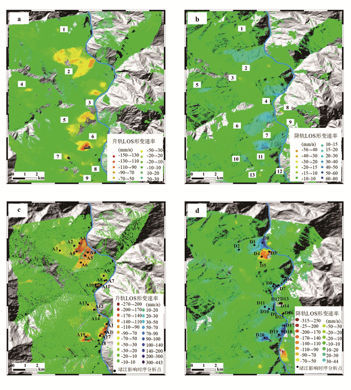
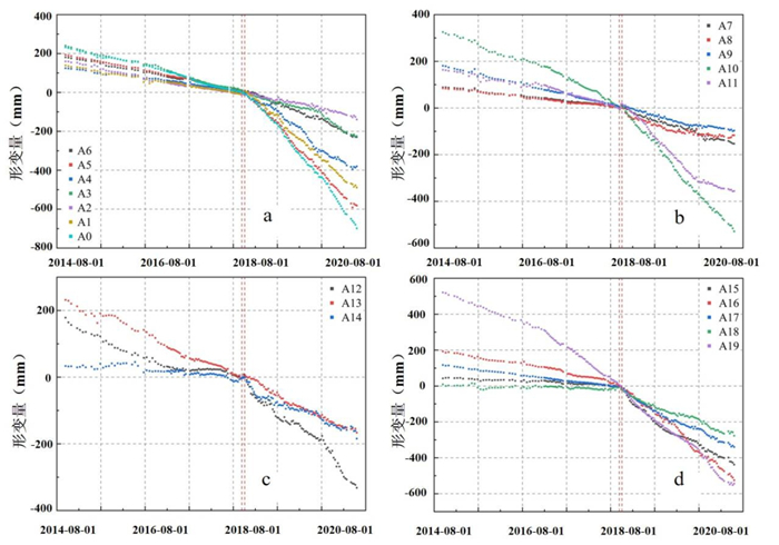
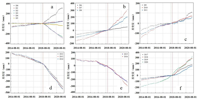
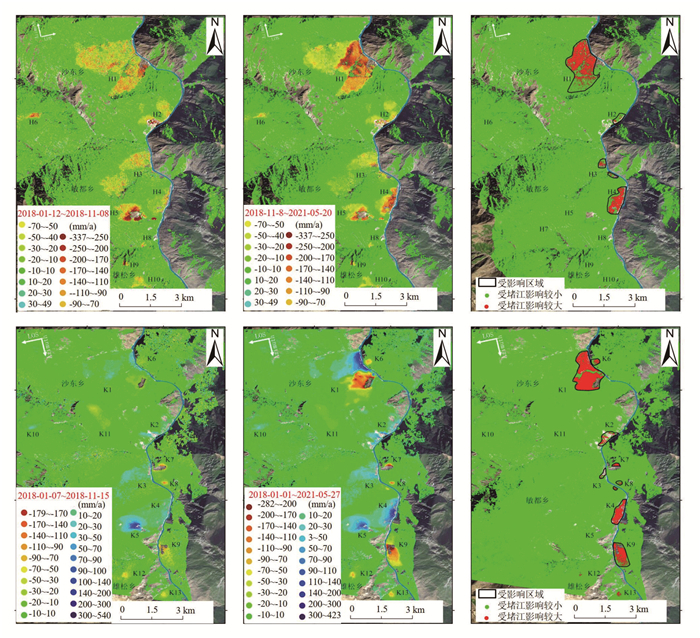
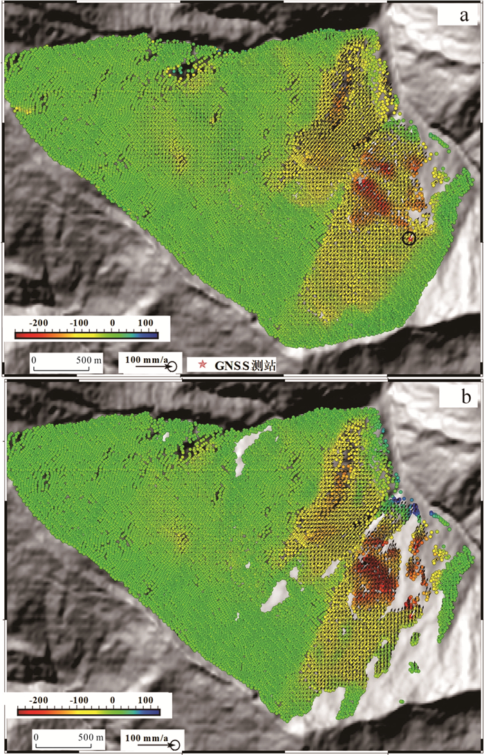
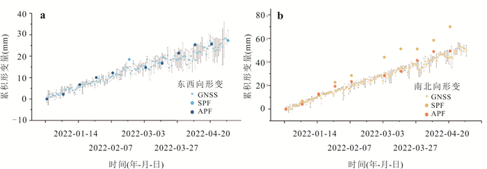
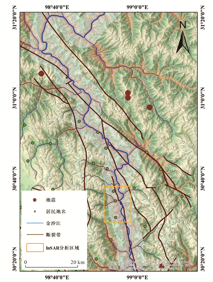
This study employs the SBAS-InSAR technique to process Sentinel-1A ascending and descending orbit SAR data from 2014 to 2022, focusing on the impact of the Baige landslide-induced river damming event on the activity of the nearest downstream landslide cluster. The Shadong landslide, which was significantly affected by the damming, was selected for terrain-constrained three-dimensional (3D) deformation inversion using InSAR, with GNSS observations used to validate model performance. Results indicate that, following the damming event, deformation rates of the riverside landslides generally increased by a factor of 3 to 7. In particular, the Shadong landslide, located on the concave bank of the Jinsha River, exhibited a notably impacted area of approximately 1.85 km2, with the maximum deformation rate increasing up to 7 times compared to the pre-damming period. The 3D deformation analysis demonstrates that the Aspect-Parallel Flow (APF) terrain-constrained model outperforms the Surface-Parallel Flow (SPF) model in reconstructing the deformation pattern of the Shadong landslide.

|
Berardino, P., Fornaro, G., Lanari, R., et al., 2002. A New Algorithm for Surface Deformation Monitoring Based on Small Baseline Differential SAR Interferograms. IEEE Transactions on Geoscience and Remote Sensing, 40(11): 2375-2383. https://doi.org/10.1109/TGRS.2002.803792
|
|
Chai, H. J., Liu, H. C., Zhang, Z. Y., 2000. Development and Distribution Characteristics of Dujiang Landslide in China. Mountain Research, 18(S1): 51-54 (in Chinese with English abstract).
|
|
Chen, J. P., Li, H. Z., 2016. Genetic Mechanism and Disasters Features of Complicated Structural Rock Mass along the Rapidly Uplift Section at the Upstream of Jinsha River. Journal of Jilin University (Earth Science Edition), 46(4): 1153-1167 (in Chinese with English abstract).
|
|
Evans, S. G., Delaney, K. B., Hermanns, R. L., et al., 2011. The Formation and Behaviour of Natural and Artificial Rockslide Dams; Implications for Engineering Performance and Hazard Management. Natural and Artificial Rockslide Dams. Springer Berlin Heidelberg, Berlin, Heidelberg, 1-75.
|
|
Fan, X. M., Dufresne, A., Siva Subramanian, S., et al., 2020. The Formation and Impact of Landslide Dams – State of the Art. Earth-Science Reviews, 203: 103116. https://doi.org/10.1016/j.earscirev.2020.103116
|
|
Fan, X. M., Xu, Q., Alonso-Rodriguez, A., et al., 2019. Successive Landsliding and Damming of the Jinsha River in Eastern Tibet, China: Prime Investigation, Early Warning, and Emergency Response. Landslides, 16(5): 1003-1020. https://doi.org/10.1007/s10346-019-01159-x
|
|
Franco, A., Moernaut, J., Schneider-Muntau, B., et al., 2021. Triggers and Consequences of Landslide-Induced Impulse Waves–3D Dynamic Reconstruction of the Taan Fiord 2015 Tsunami Event. Engineering Geology, 294: 106384. https://doi.org/10.1016/j.enggeo.2021.106384
|
|
Guo, C. B., Wu, R. A., Zhong, N., et al., 2024. Large Landslides along Active Tectonic Zones of Eastern Tibetan Plateau: Background and Mechanism of Landslide Formation. Earth Science, 49(12): 4635-4658 (in Chinese with English abstract).
|
|
Guo, C. B., Yan, Y. Q., Zhang, Y. S., et al., 2021. Study on the Creep-Sliding Mechanism of the Giant Xiongba Ancient Landslide Based on the SBAS-InSAR Method, Tibetan Plateau, China. Remote Sensing, 13(17): 3365. https://doi.org/10.3390/rs13173365
|
|
Hu, X., Lu, Z., Pierson, T. C., et al., 2018. Combining InSAR and GPS to Determine Transient Movement and Thickness of a Seasonally Active Low-Gradient Translational Landslide. Geophysical Research Letters, 45(3): 1453-1462. https://doi.org/10.1002/2017GL076623
|
|
Joughin, I. R., Kwok, R., Fahnestock, M. A., 1998. Interferometric Estimation of Three-Dimensional Ice-Flow Using Ascending and Descending Passes. IEEE Transactions on Geoscience and Remote Sensing, 36(1): 25-37. https://doi.org/10.1109/36.655315
|
|
Li, M. H., Zhang, L., Ding, C., et al., 2020. Retrieval of Historical Surface Displacements of the Baige Landslide from Time-Series SAR Observations for Retrospective Analysis of the Collapse Event. Remote Sensing of Environment, 240: 111695. https://doi.org/10.1016/j.rse.2020.111695
|
|
Li, X., Guo, C. B., Yang, Z. H., et al., 2021. Development Characteristics and Formation Mechanism of the Xiongba Giant Ancient Landslide in the Jinshajiang Tectonic Zone. Geoscience, 35(1): 47-55 (in Chinese with English abstract).
|
|
Liu, X. J., Zhao, C. Y., Zhang, Q., et al., 2021a. Integration of Sentinel-1 and ALOS/PALSAR-2 SAR Datasets for Mapping Active Landslides along the Jinsha River Corridor, China. Engineering Geology, 284: 106033. https://doi.org/10.1016/j.enggeo.2021.106033
|
|
Liu, X. J., Zhao, C. Y., Zhang, Q., et al., 2021b. Three-Dimensional and Long-Term Landslide Displacement Estimation by Fusing C- and L-Band SAR Observations: A Case Study in Gongjue County, Tibet, China. Remote Sensing of Environment, 267: 112745. https://doi.org/10.1016/j.rse.2021.112745
|
|
Penna, D., Brocca, L., Borga, M., et al., 2013. Soil Moisture Temporal Stability at Different Depths on Two Alpine Hillslopes during Wet and Dry Periods. Journal of Hydrology, 477: 55-71. https://doi.org/10.1016/j.jhydrol.2012.10.052
|
|
Samsonov, S. V., d'Oreye, N. F., 2016. Multidimensional Time‐Series Analysis of Ground Deformation from Multiple InSAR Data Sets Applied to Virunga Volcanic Province. Geophysical Journal International, 191: 1095-1108. https://doi.org/10.1111/J.1365-246X.2012.05669.X
|
|
Schulz, W. H., Coe, J. A., Ricci, P. P., et al., 2017. Landslide Kinematics and Their Potential Controls from Hourly to Decadal Timescales: Insights from Integrating Ground-Based InSAR Measurements with Structural Maps and Long-Term Monitoring Data. Geomorphology, 285: 121-136. https://doi.org/10.1016/j.geomorph.2017.02.011
|
|
Song, C., Yu, C., Li, Z. H., et al., 2022. Triggering and Recovery of Earthquake Accelerated Landslides in Central Italy Revealed by Satellite Radar Observations. Nature Communications, 13: 7278. https://doi.org/10.1038/s41467-022-35035-5
|
|
Wang, G. F., Bi, Y. H., Li, H., et al., 2025. Developmental and Distribution Characteristics and Formation Mechanisms of Large-Scale Landslide Disaster Chains in Bailong River Basin. Earth Science, 50(10): 3885-3904(in Chinese with English abstract).
|
|
Wang, L. C., Wen, M. S., Feng, Z., et al., 2019. Researches on the Baige Landslide at Jinshajiang River, Tibet, China. The Chinese Journal of Geological Hazard and Control, 30(1): 1-9 (in Chinese with English abstract).
|
|
Yang, Y. T., Liu, M., Quincey, D. J., et al., 2023. Cyclic Landslide-Flood Chains along a Major Mountain River. Geomorphology, 439: 108835. https://doi.org/10.1016/j.geomorph.2023.108835
|
|
Yao, J. M., Yao, X., Liu, X. H., et al., 2022. Landslide Detection and Mapping Based on SBAS-InSAR and PS-InSAR: A Case Study in Gongjue County, Tibet, China. Remote Sensing, 14(19): 4728. https://doi.org/10.3390/rs14194728
|
|
Zhu, S. N., Yin, Y. P., Wang, M., et al., 2021. Instability Mechanism and Disaster Mitigation Measures of Long-Distance Landslide at High Location in Jinsha River Junction Zone: Case Study of Sela Landslide in Jinsha River, Tibet. Chinese Journal of Geotechnical Engineering, 43(4): 688-697 (in Chinese with English abstract).
|
|
Zhu, W., Yang, L. Y., Cheng, Y. Q., et al., 2024. Active Thickness Estimation and Failure Simulation of Translational Landslide Using Multi-Orbit InSAR Observations: A Case Study of the Xiongba Landslide. International Journal of Applied Earth Observation and Geoinformation, 129: 103801. https://doi.org/10.1016/j.jag.2024.103801
|
|
柴贺军, 刘汉超, 张倬元, 2000. 中国堵江滑坡发育分布特征. 山地学报, 18(增刊1): 51-54.
|
|
陈剑平, 李会中, 2016. 金沙江上游快速隆升河段复杂结构岩体灾变特征与机理. 吉林大学学报(地球科学版), 46(4): 1153-1167.
|
|
郭长宝, 吴瑞安, 钟宁, 等, 2024. 青藏高原东部活动构造带大型滑坡成灾背景与灾变机制. 地球科学, 49(12): 4635-4658. doi: 10.3799/dqkx.2024.124
|
|
李雪, 郭长宝, 杨志华, 等, 2021. 金沙江断裂带雄巴巨型古滑坡发育特征与形成机理. 现代地质, 35(1): 47-55.
|
|
王高峰, 毕远宏, 李浩, 等, 2025. 白龙江流域特大滑坡灾害链发育分布特征及形成机制. 地球科学, 50(10): 3885-3904. doi: 10.3799/dqkx.2025.151
|
|
王立朝, 温铭生, 冯振, 等, 2019. 中国西藏金沙江白格滑坡灾害研究. 中国地质灾害与防治学报, 30(1): 1-9.
|
|
朱赛楠, 殷跃平, 王猛, 等, 2021. 金沙江结合带高位远程滑坡失稳机理及减灾对策研究: 以金沙江色拉滑坡为例. 岩土工程学报, 43(4): 688-697.
|
Figures(8) / Tables(2)


 DownLoad: