- 中文版:
- EI 100%收录
- 英文版
- SCI 100%收录


中国出版政府奖提名奖
中国百强科技报刊
湖北出版政府奖
中国高校百佳科技期刊
中国最美期刊
中国出版政府奖提名奖
中国百强科技报刊
湖北出版政府奖
中国高校百佳科技期刊
中国最美期刊
| Citation: | LIU Jun-qi, MAO Xiao-ping, 2009. Integrated Mode and Key Technique of Quantificational Expressing for Mineral Resource Prospecting. Earth Science, 34(2): 375-380.

|
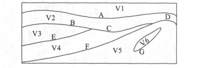
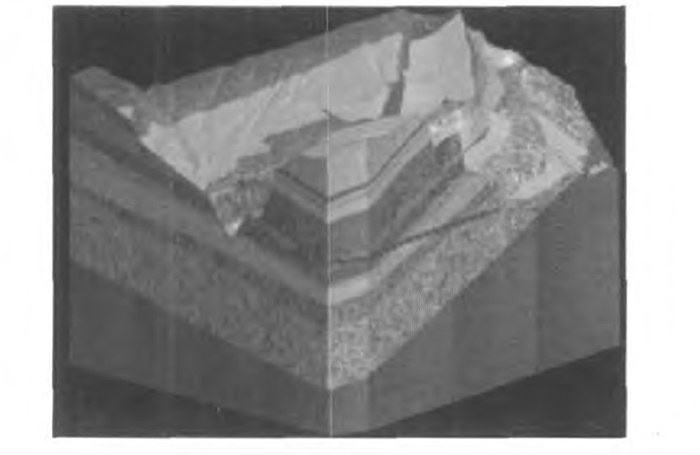
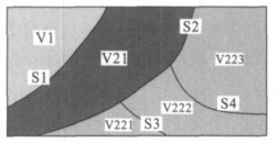
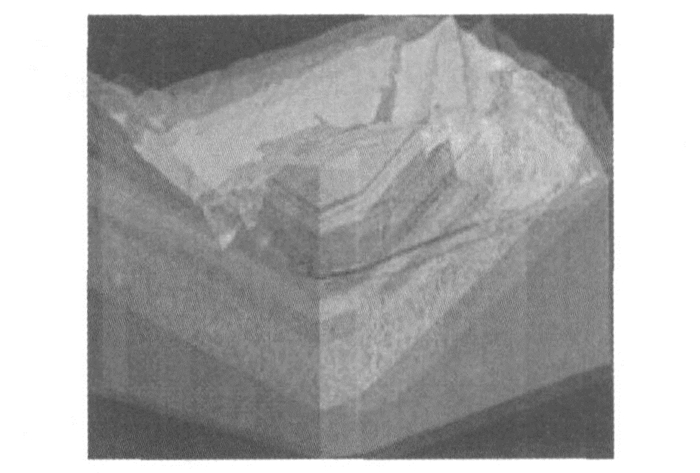
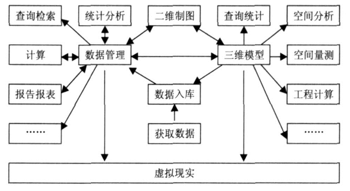
Mineral resource prospecting aims at providing sufficient information on mine state for further resource evaluation and production.In this process, the information technique can be utilized to increase the efficiency and quality of data analysis and processing.In this paper, the authors consider that data management and three dimensional model and virtual reality are three pivotal taches of information processing, by which we can systematically integrate the information technique for mineral resource prospecting.And the authors put forward a new 3D data structure and a new systematic method for expressing geological solid, which have already been successfully applied to multi-resource perambulation work.

|
Bastante, F. G., Taboada, J., Alejano, L. R., et al., 2005. Evaluation of the resources of a slate deposit using indicator Kriging. Engineering Geology, 81 (4): 407-418. doi: 10.1016/j.enggeo.2005.08.003
|
|
Buchele, S. F., Crawford, R. H., 2004. Three-dimensional half space constructive solid geometry tree construction from implicit boundary representations. Computer-Aided Design, 36 (1115): 1063-1073. https://www.deepdyve.com/lp/association-for-computing-machinery/three-dimensional-halfspace-constructive-solid-geometry-tree-Rqn0kVowME
|
|
Cervera, E., Trevelyan, J., 2005. Evolutionary structural optimisation based on boundary representation of NURBS. Part Ⅱ: 3D algorithms. Computers & Structures, 83 (23-24): 1917-1929.
|
|
Du, D. S., 1995. Integration and application of GPS and RSand GIS. Wuhan Technical University of Surveying andMapping Press, Wuhan, 200-209 (in Chinese).
|
|
Elber, G., Shapiro, V., 2004. Editorial to special issue on solid modeling theory and applications. Computer-Aided Design, 36 (1115): 1011-1012. https://www.researchgate.net/publication/220583810_Editorial_to_special_issue_on_solid_modeling_theory_and_applications
|
|
Fang, X. F., 2007.3D simulation designing system for urban planning based on virtual reality. Computer Simulation, 24 (3): 230-234, 285 (in Chinese with English abstract).
|
|
Fleisig, R. V., Spence, A. D., 2005. Techniques for accelerating B-Rep based parallel machining simulation. Computer-Aided Design, 37 (12): 1229-1240. doi: 10.1016/j.cad.2004.11.008
|
|
Hou, Q., Chen, X. W., 2007. Simulation about liquid based on OpenGL. Application Research of Computers, 24 (2): 186-188 (in Chinese with English abstract).
|
|
Li, D. R., 1997. On definition, theory and key technics of the integration of GPS, RS and GIS. Journal of Remote Sensing, 1 (1): 64-68 (in Chinese with English abstract). https://en.cnki.com.cn/Article_en/CJFDTOTAL-YGXB199701008.htm
|
|
Lions, J. L., Pironneau, O., 1999. Domain decomposition methods for CAD. Comptes Rendus de I'Académie des Sciences-Series Ⅰ-Mathematics, 328 (1): 73-80.
|
|
Liu, J. Q., 2007. Research and application in 3D information system of water conservancy and electricity engineering geology (Dissertation). China University of Geosciences, Wuhan (in Chinese with English abstract).
|
|
Liu, J. Q., Huang, C. Q., Wu, C. L., 2007. Management strategy and realized methods for geological information of Yangtze River embankment engineering. Journal of Yangtze River Scientific Research Institute, 24 (4): 38-41 (in Chinese with English abstract).
|
|
Liu, J. Q., Zhou, X. Z., Wu, C. L., et al., 2008. The problem of technology integrated to process geological information for water conservancy and electricity engineering. The Yangtze River, 39 (12): 58-60, 105 (in Chinese).
|
|
Mun, W. L., Surendra, R., 2003. Pose-invariant face recognition using a 3D deformable model. Pattern Recognition, 36 (8): 1835-1846. doi: 10.1016/S0031-3203(03)00008-6
|
|
Reed, M. K., Allen, P. K., 1999. 3-D modeling from range imagery: An incremental method with a planning component. Image and Vision Computing, 17 (2): 99-111. doi: 10.1016/S0262-8856(98)00114-0
|
|
Sen, D., Srikanth, T. K., 2008. Efficient computation of volume fractions for multi-material cell complexes in a grid by slicing. Computers & Geosciences, 34 (7): 754-782. https://www.sciencedirect.com/science/article/pii/S0098300408000034
|
|
Shih, F. Y., Gaddipati, V., 2005. Geometric modeling and representation based on sweep mathematical morphology. Information Sciences, 171, 1-3: 213-231. https://www.sciencedirect.com/science/article/pii/S0020025504001331
|
|
Tian, Y., Peters, C. D., Kumar, S. V., et al., 2008. High-performance land surface modeling with a Linux cluster. Computers & Geosciences, 34 (11): 1492-1504.
|
|
Wang, Y., 2007. Periodic surface modeling for computer aided nano design. Computer-Aided Design, 39 (3): 179-189. doi: 10.1016/j.cad.2006.09.005
|
|
Wu, C. L., 1998. Development and applications of geological and mineral resources point-source information system. Earth Science-Journal of China University of Geosciences, 23 (2): 193-198 (in Chinese with English abstract).
|
|
杜道生, 1995. GPS、RS、GIS的集成与应用. 武汉: 武汉测绘科技大学出版社, 200-209.
|
|
方小峰, 2007. 基于虚拟现实的城市规划三维仿真设计系统. 计算机仿真, 24 (3): 230-234, 285. https://www.cnki.com.cn/Article/CJFDTOTAL-JSJZ200703061.htm
|
|
侯庆, 陈孝威, 2007. 基于OpenGL的流体交互式仿真. 计算机应用研究, 24 (2): 186-188. doi: 10.3969/j.issn.1001-3695.2007.02.062
|
|
李德仁, 1997. 论RS, GPS与GIS集成的定义、理论与关键技术. 遥感学报, 1 (1): 64-68. https://www.cnki.com.cn/Article/CJFDTOTAL-YGXB199701008.htm
|
|
刘军旗, 2007. 水利水电工程地质三维信息系统研究与应用(博士学位论文). 武汉: 中国地质大学.
|
|
刘军旗, 黄长青, 吴冲龙, 2007. 长江堤防工程地质信息管理策略及实现方法. 长江科学院院报, 24 (4): 38-41. https://www.cnki.com.cn/Article/CJFDTOTAL-CJKB200704011.htm
|
|
刘军旗, 周兴龙, 吴冲龙, 等, 2008. 水电工程地质信息处理技术集成问题探讨. 人民长江, 39 (12): 58-60, 105. https://www.cnki.com.cn/Article/CJFDTOTAL-RIVE200812025.htm
|
|
吴冲龙, 1998. 地质矿产点源信息系统的开发与应用. 地球科学—中国地质大学学报, 23 (2): 193-198. https://www.cnki.com.cn/Article/CJFDTOTAL-DQKX802.018.htm
|
Figures(7)

 DownLoad: