2017 Vol. 42, No. 12
column
- Ductile Deformation and Continental Rheology, Amalgamation of the Micro-Continents and Their Evolution in NE China
- Ductile Deformation and Continental Rheology, Amalgamation of the Micro-Continents and Their Evolution in NEChina
- Mineralogy, Petrology and Mineral Deposits
- Stratigraphy
- Geophysics
- Remote Sensing Geology
- Hydrogeology
Display Method:
 PDF 267KB
2017, 42(12): 2105-2116.
doi: 10.3799/dqkx.2017.135
Abstract:
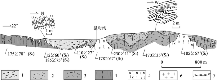
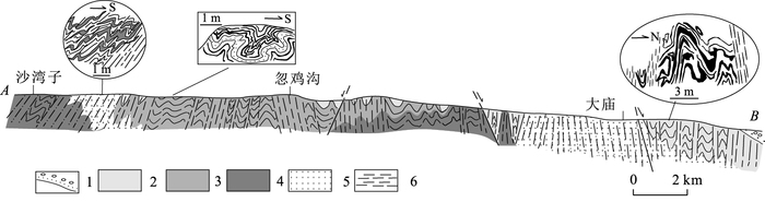
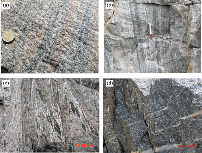
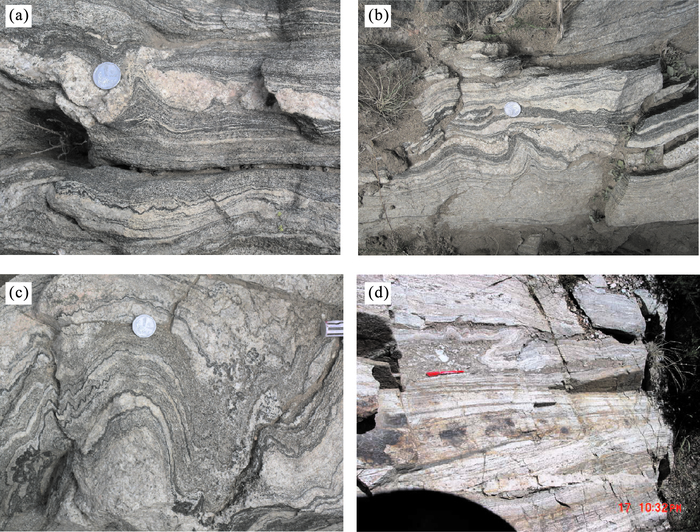
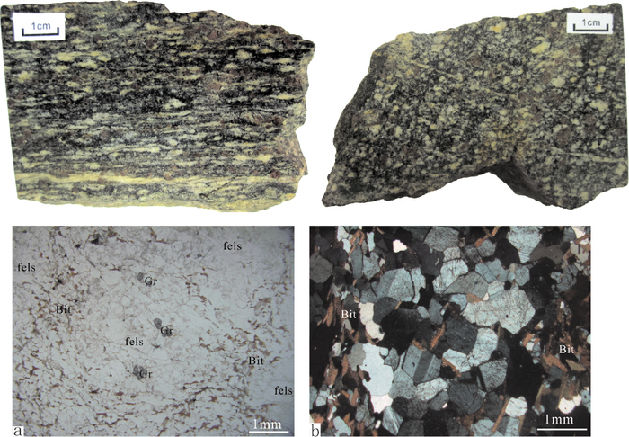
The high-grade metamorphic rocks in Daqing Mountain area not only record the early formation and evolution of the North China craton, but also retain rheomorphic characteristics in the middle-lower crust. These rocks undergwent metamorphism, deformation and anatexis of high amphibolite facies-granulite facies in the lower crust, forming the complex structure styles and association of structural elements. As the main structural feature in the high-grade metamorphic rocks, the ductile shear zones controlled the major tectonic framework of Pre-Cambrian high-grade metamorphic rocks in this area. According to the superimposed reformation between the geological occurrence and deformed deformation characteristics with the structural elements, the ductile shear zones are divided into early subhorizontal bedding extension type and later steep type. The subhorizontal bedding extension ductile shear zone remained at the locations that experienced weak-deformation in later stage. They formed along interfaces of different geological bodies and lithologies under an extensional deformation system. The later steep ductile shear zone was distributed in near E-W direction with a larger scale. It formed in the later orogenic compressional environment and reformed the early structural features. These two types of ductile shear zone were both formed under the high amphibolite facies-granulite facies metamorphism in the middle-lower crust. And, the mian deformation is the melt-enhanced grain side diffusion and the grain flow, which caused a large scale plastic flow of the rocks. Some macrostructural elemenrs, such as asymmetry flowing fabric, perthitic and band structural, melting lineation and intraformational flowing fold were formed. However, the microfabrics features of the rocks are equilibrium textures of triple sides, similar to the metafabrics of rocks by static crystalline metamorphism; the deforrnation of mineral grain is not obvious and the intracrystalline deformation textures did not develop:the metamorphic tectonite of lower crustal tectonic 1evel, the tectonic gneiss, was formed.
The high-grade metamorphic rocks in Daqing Mountain area not only record the early formation and evolution of the North China craton, but also retain rheomorphic characteristics in the middle-lower crust. These rocks undergwent metamorphism, deformation and anatexis of high amphibolite facies-granulite facies in the lower crust, forming the complex structure styles and association of structural elements. As the main structural feature in the high-grade metamorphic rocks, the ductile shear zones controlled the major tectonic framework of Pre-Cambrian high-grade metamorphic rocks in this area. According to the superimposed reformation between the geological occurrence and deformed deformation characteristics with the structural elements, the ductile shear zones are divided into early subhorizontal bedding extension type and later steep type. The subhorizontal bedding extension ductile shear zone remained at the locations that experienced weak-deformation in later stage. They formed along interfaces of different geological bodies and lithologies under an extensional deformation system. The later steep ductile shear zone was distributed in near E-W direction with a larger scale. It formed in the later orogenic compressional environment and reformed the early structural features. These two types of ductile shear zone were both formed under the high amphibolite facies-granulite facies metamorphism in the middle-lower crust. And, the mian deformation is the melt-enhanced grain side diffusion and the grain flow, which caused a large scale plastic flow of the rocks. Some macrostructural elemenrs, such as asymmetry flowing fabric, perthitic and band structural, melting lineation and intraformational flowing fold were formed. However, the microfabrics features of the rocks are equilibrium textures of triple sides, similar to the metafabrics of rocks by static crystalline metamorphism; the deforrnation of mineral grain is not obvious and the intracrystalline deformation textures did not develop:the metamorphic tectonite of lower crustal tectonic 1evel, the tectonic gneiss, was formed.
2017, 42(12): 2117-2128.
doi: 10.3799/dqkx.2017.136
Abstract:
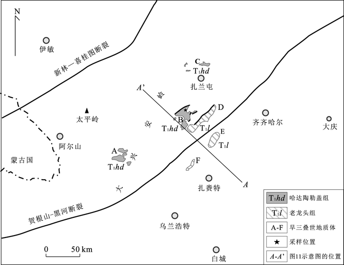
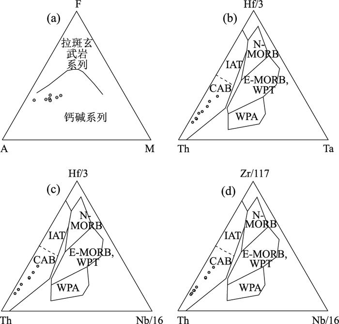
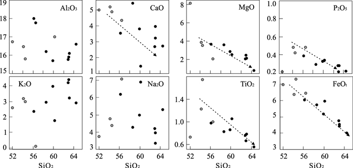
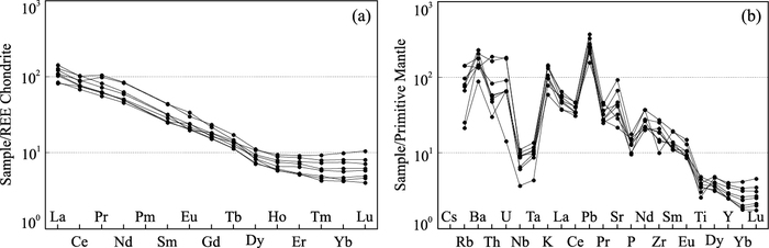
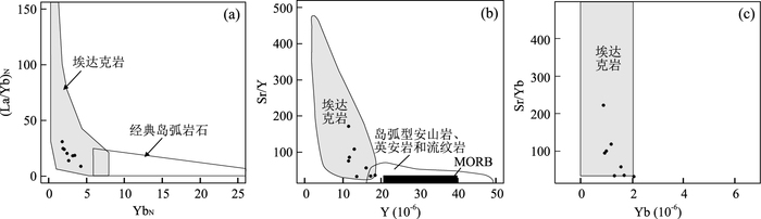
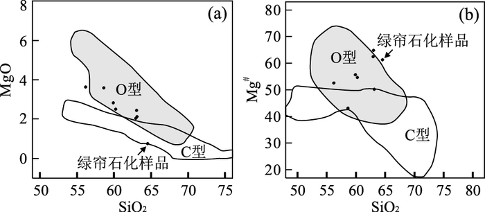
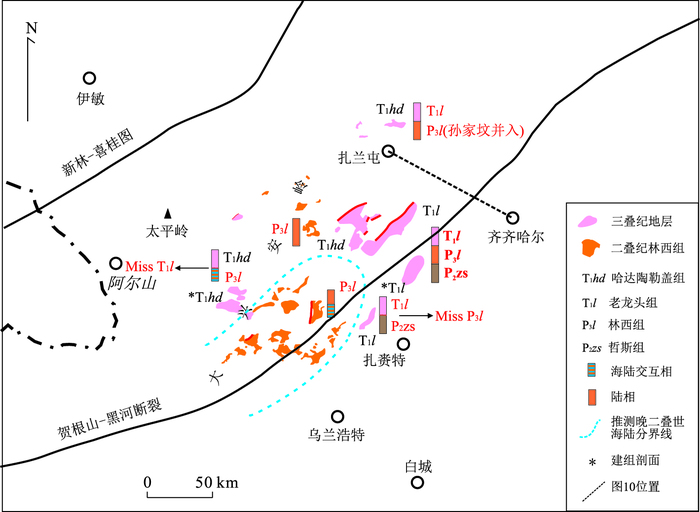
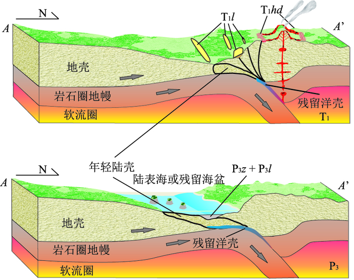
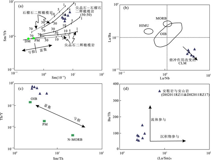
In order to study the tectonic setting of the Early Triassic of the middle of the Greater Xing'an Range, the volcanic rocks of Lower Triassic Hadataolegai Formation was studied by field observation. Respectively, the main elements and trace elements were analyzed by XRF and ICP-MS. The results show that the volcanic rocks are a series of calcareous series rocks with high Sr, low Yb, Y and high Sr/Y ratios, showing geochemical features of O-type adakites are related to subduction of oceanic slab. we suggests Paleo-Asian Ocean collision along the line of Silumulon River-Changchun-Yanji which activated Hegenshan-Nenjiang-Heihe structural belt in Early Triassic. The collision pushed the young crust to subduct northward along Hegenshan-Nenjiang-Heihe line. The residual Paleozoic oceanic crust are advanced to the deeper mantle melting and then the Hadataolegai Formation adakites were formed. At the same time, the Laolongtou Formation that is lacustrine clastic sediments was deposited in the intermountain basin.
In order to study the tectonic setting of the Early Triassic of the middle of the Greater Xing'an Range, the volcanic rocks of Lower Triassic Hadataolegai Formation was studied by field observation. Respectively, the main elements and trace elements were analyzed by XRF and ICP-MS. The results show that the volcanic rocks are a series of calcareous series rocks with high Sr, low Yb, Y and high Sr/Y ratios, showing geochemical features of O-type adakites are related to subduction of oceanic slab. we suggests Paleo-Asian Ocean collision along the line of Silumulon River-Changchun-Yanji which activated Hegenshan-Nenjiang-Heihe structural belt in Early Triassic. The collision pushed the young crust to subduct northward along Hegenshan-Nenjiang-Heihe line. The residual Paleozoic oceanic crust are advanced to the deeper mantle melting and then the Hadataolegai Formation adakites were formed. At the same time, the Laolongtou Formation that is lacustrine clastic sediments was deposited in the intermountain basin.
2017, 42(12): 2129-2145.
doi: 10.3799/dqkx.2017.137
Abstract:
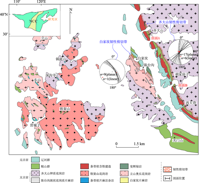
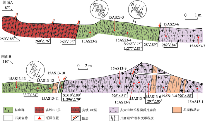
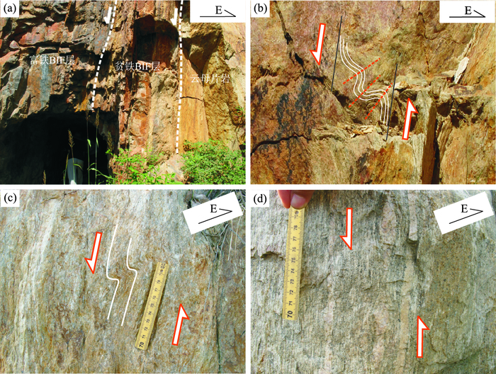
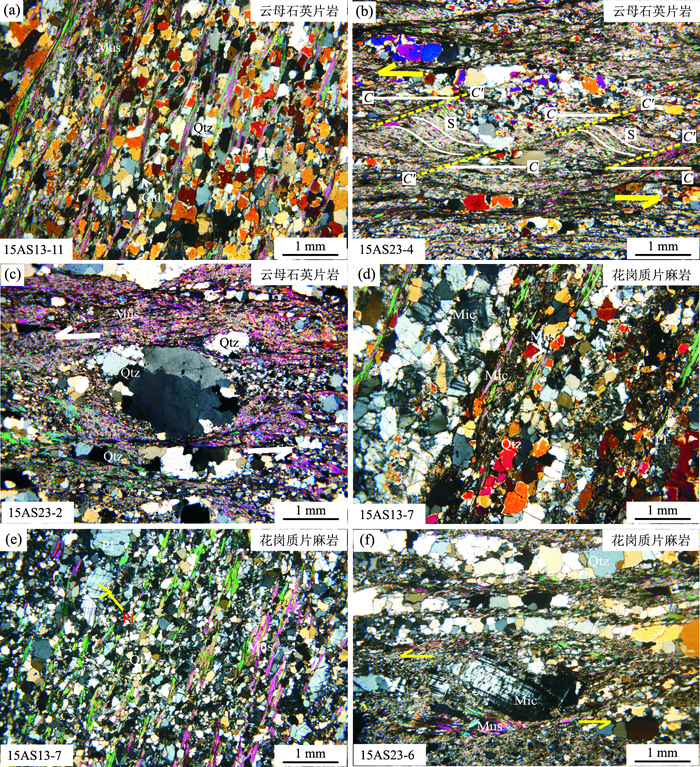
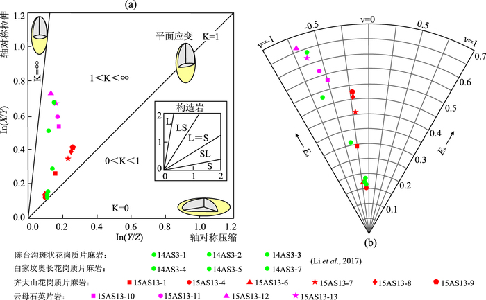
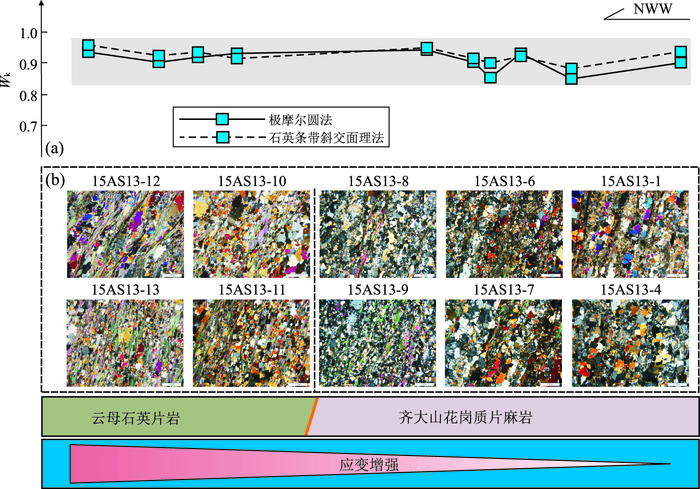
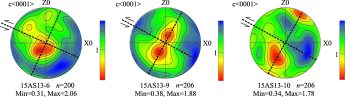
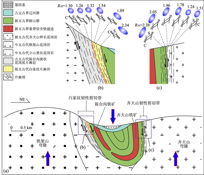
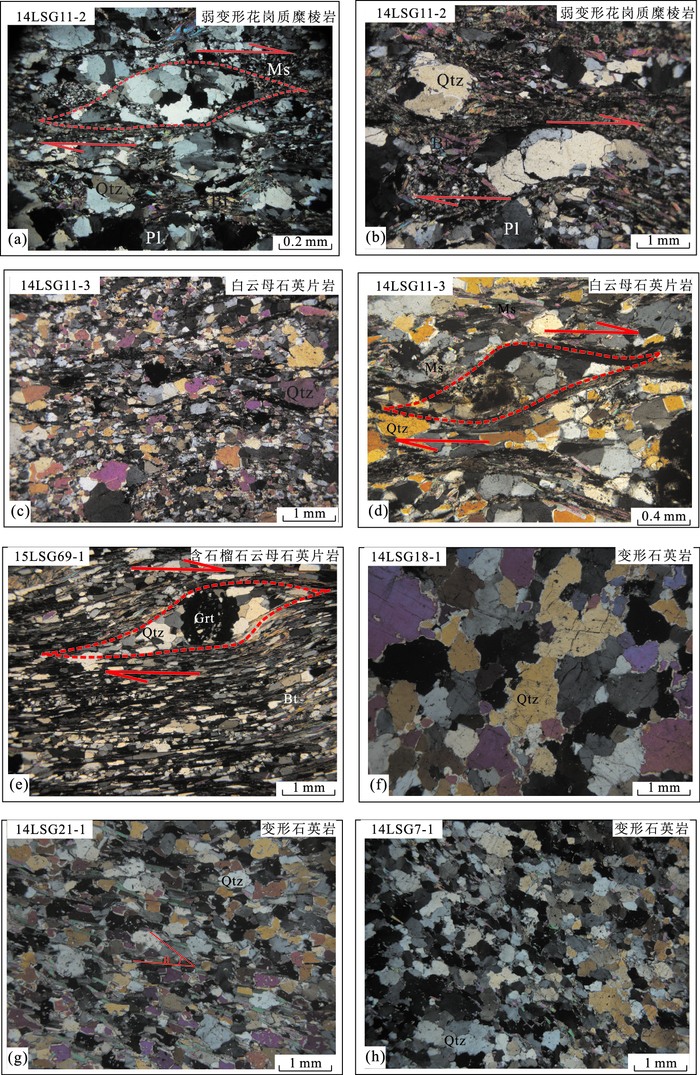
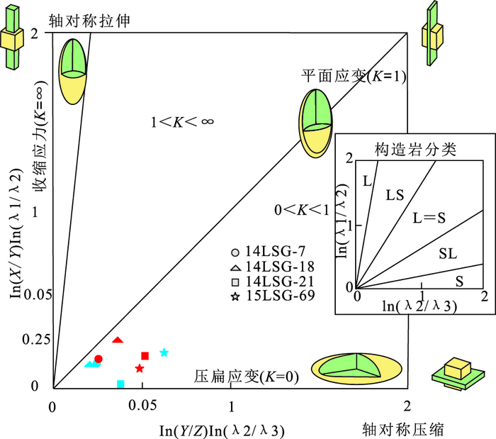
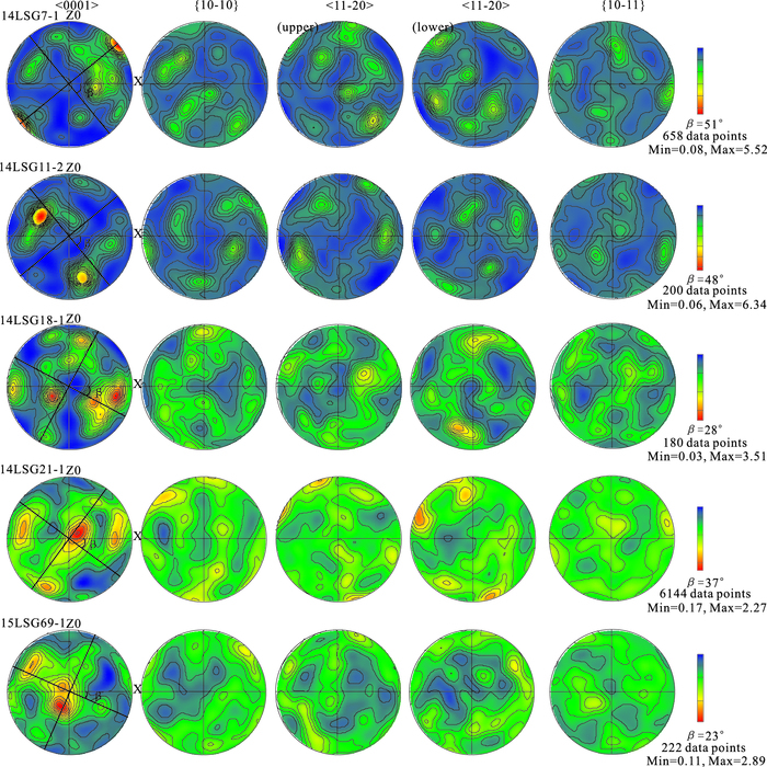
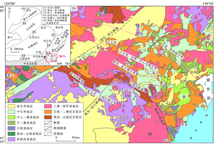
The controversy over the Archean tectonic regimes has lasted several decades focused on the horizontal and vertical tectonics, the two classical tectonic models for Archean.Thus, more studies of the early crustal tectonic evolution are requisite for better understanding geodynamic regimes in the early Precambrian. In this study, detailed structural analysis of Qidashan down-slip ductile shear zones which developed in the eastern Anshan area was carried out and an example for revealing Neoarchean vertical tectonics is provided. The ribbon structures formed by intensely elongated felsic minerals are widespread in the deformed gneisses. The quartz C-axis fabric patterns obtained by electron backscatter diffraction technique imply low to middle temperature non-coaxial deformation with active rhomb < a > slip and basal < a > slip. Deformation behaviors of minerals and quartz crystallographic preferred orientations demonstrate that the rocks underwent mylonitization at a temperature of 400-500℃ under greenschist facies metamorphic conditions. Dislocation creep is the main rock deformation mechanism within the shear zones. Finite strain measurement results suggest that toward the iron ore belt, the tectonites change from L=S-to LS-type and the strain intensity exhibits an enhanced trend across the shear zones. Kinematic vorticity values (>0.75) indicate that the deformed rocks in ductile shear zones were produced by steady-state simple-shear dominated general shear. Compared to the Baijiafen ductile shear zone to the west, the Qidashan and Baijiafen ductile shear zones both have mutually down-slip kinematic characteristics, indicating that the Neoarchean crust growth and tectonic evolution in Anshan area is dominated by vertical tectonics.
The controversy over the Archean tectonic regimes has lasted several decades focused on the horizontal and vertical tectonics, the two classical tectonic models for Archean.Thus, more studies of the early crustal tectonic evolution are requisite for better understanding geodynamic regimes in the early Precambrian. In this study, detailed structural analysis of Qidashan down-slip ductile shear zones which developed in the eastern Anshan area was carried out and an example for revealing Neoarchean vertical tectonics is provided. The ribbon structures formed by intensely elongated felsic minerals are widespread in the deformed gneisses. The quartz C-axis fabric patterns obtained by electron backscatter diffraction technique imply low to middle temperature non-coaxial deformation with active rhomb < a > slip and basal < a > slip. Deformation behaviors of minerals and quartz crystallographic preferred orientations demonstrate that the rocks underwent mylonitization at a temperature of 400-500℃ under greenschist facies metamorphic conditions. Dislocation creep is the main rock deformation mechanism within the shear zones. Finite strain measurement results suggest that toward the iron ore belt, the tectonites change from L=S-to LS-type and the strain intensity exhibits an enhanced trend across the shear zones. Kinematic vorticity values (>0.75) indicate that the deformed rocks in ductile shear zones were produced by steady-state simple-shear dominated general shear. Compared to the Baijiafen ductile shear zone to the west, the Qidashan and Baijiafen ductile shear zones both have mutually down-slip kinematic characteristics, indicating that the Neoarchean crust growth and tectonic evolution in Anshan area is dominated by vertical tectonics.
2017, 42(12): 2146-2173.
doi: 10.3799/dqkx.2017.138
Abstract:
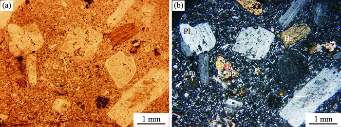
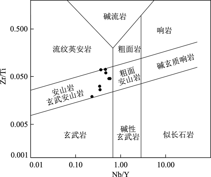
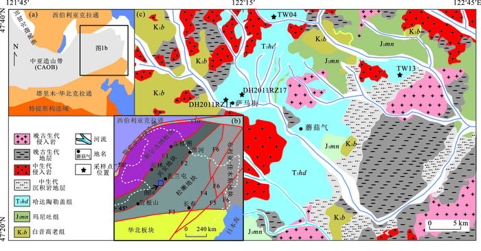
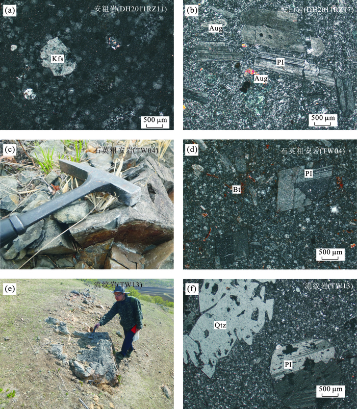
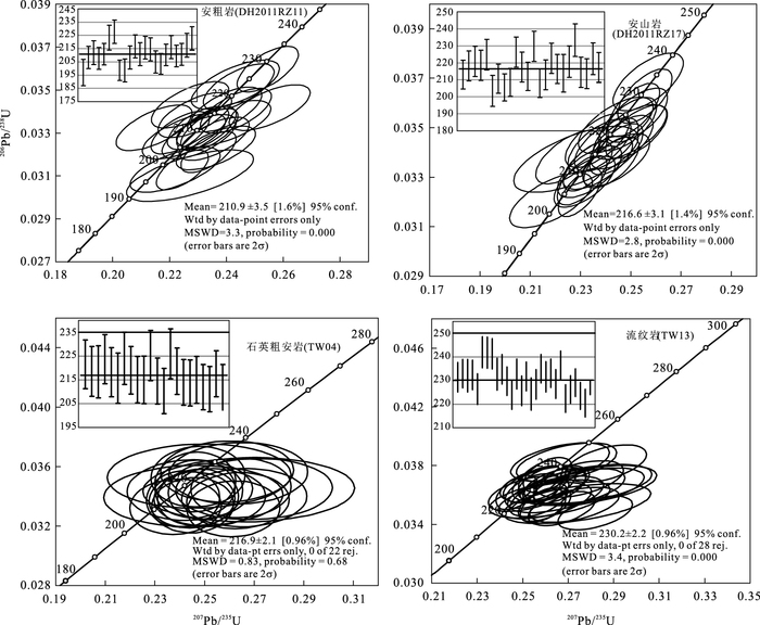
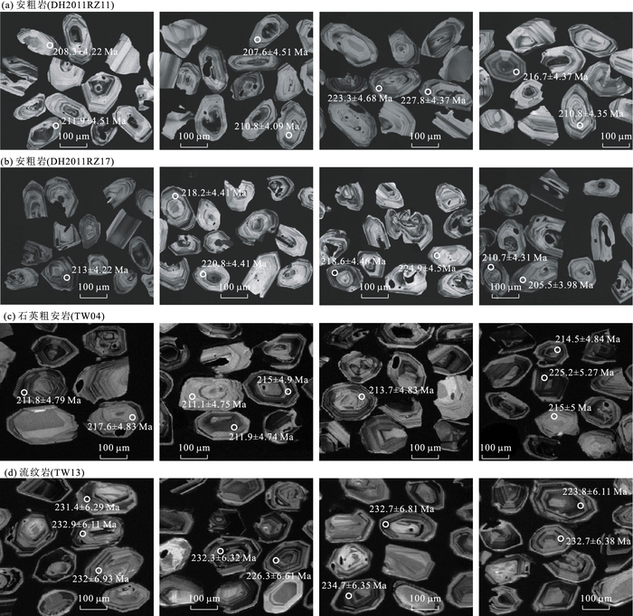
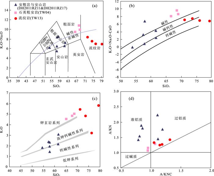
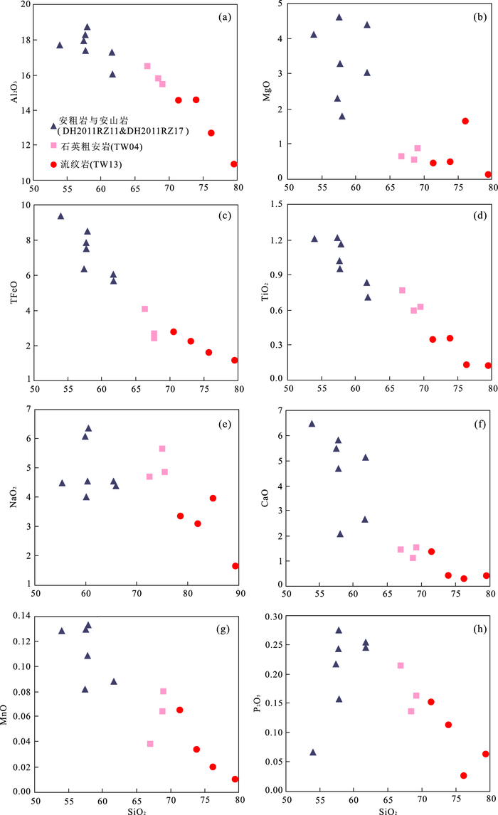
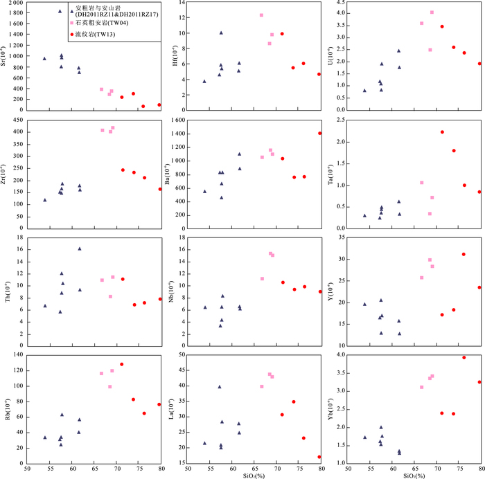
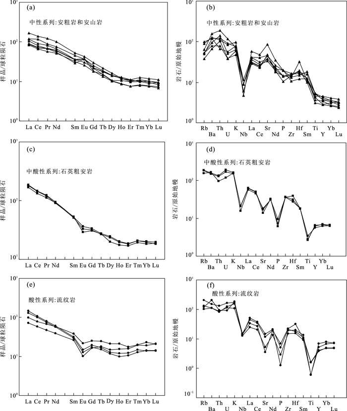
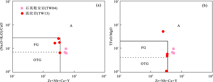
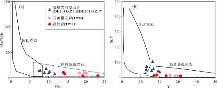
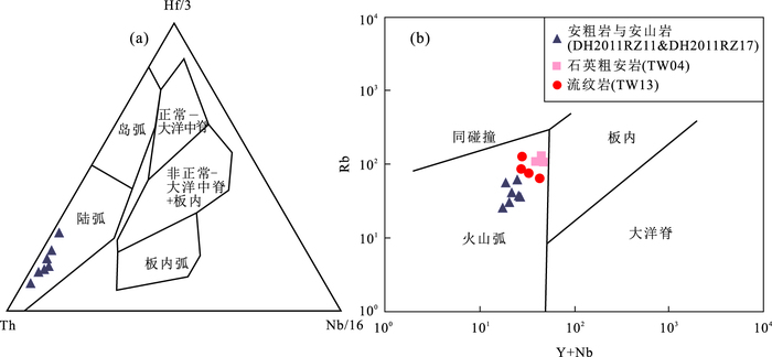
To realize the tectonic setting at central part of Great Xing'an Range during Late Triassic, petrology, zircon U-Pb chronology and geochemical of the Late Triassic Hadataolegai Fm. were analyzed in this paper. The volcanic rocks from Late Triassic Hadataolegai Fm. can be divided into three rock series which are intermediate latite and andesite, intermediate to acidic quartz trachyandensite and acid rhyolite, and their formation ages are 210.9±3.5 Ma, 216.6±3.1 Ma, 216.9±2.1 Ma and 230.2±2.2 Ma, respectively.The magma of intermediate series was derived from partial melting of lithospheric mantle which fully enriched by fluids released from subduction oceanic lithosphere.There have no or slightly crystallization fractionation but suffered seriously crustal contamination during magma upwelling.Intermediate to acidic and acidic series rocks have crustal-derived magma source features, the crystallization fractionation of intermediate to acidic magma was unconspicuous during its evolution course, but it was quite obvious to the acidic series.The southward subduction of the Okhotsk oceanic lithosphere has played an important role to the tectonic setting at central part of Great Xing'an Range during Late Triassic, and appear back-arc extension signiture at the study area.This extension background leaded by asthenosphere magma upwelling which caused by subduction oceanic lithosphere delamination, and the asthenosphere magma upwelling provides energy to the primary magma generation for volcanic rocks of the Late Triassic Hadataolegai Fm. meanwhile.
To realize the tectonic setting at central part of Great Xing'an Range during Late Triassic, petrology, zircon U-Pb chronology and geochemical of the Late Triassic Hadataolegai Fm. were analyzed in this paper. The volcanic rocks from Late Triassic Hadataolegai Fm. can be divided into three rock series which are intermediate latite and andesite, intermediate to acidic quartz trachyandensite and acid rhyolite, and their formation ages are 210.9±3.5 Ma, 216.6±3.1 Ma, 216.9±2.1 Ma and 230.2±2.2 Ma, respectively.The magma of intermediate series was derived from partial melting of lithospheric mantle which fully enriched by fluids released from subduction oceanic lithosphere.There have no or slightly crystallization fractionation but suffered seriously crustal contamination during magma upwelling.Intermediate to acidic and acidic series rocks have crustal-derived magma source features, the crystallization fractionation of intermediate to acidic magma was unconspicuous during its evolution course, but it was quite obvious to the acidic series.The southward subduction of the Okhotsk oceanic lithosphere has played an important role to the tectonic setting at central part of Great Xing'an Range during Late Triassic, and appear back-arc extension signiture at the study area.This extension background leaded by asthenosphere magma upwelling which caused by subduction oceanic lithosphere delamination, and the asthenosphere magma upwelling provides energy to the primary magma generation for volcanic rocks of the Late Triassic Hadataolegai Fm. meanwhile.
2017, 42(12): 2174-2192.
doi: 10.3799/dqkx.2017.139
Abstract:
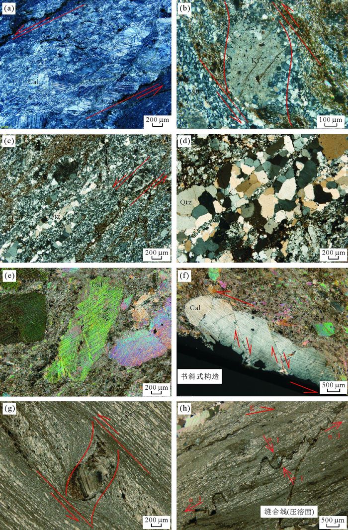
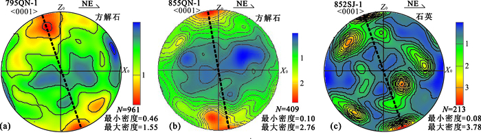
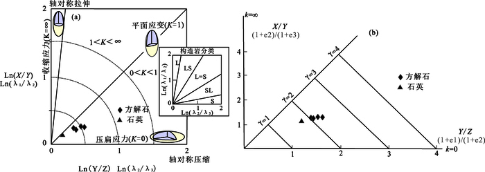
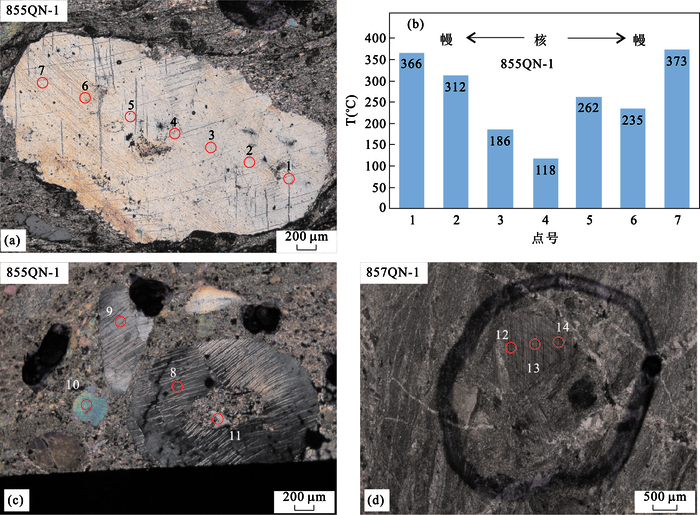
The Quannongshan area is located in the southeastern part of Changchun, at the junction of the Jiamusi-Yilan fault belt and Xar Moron suture zone. Detailed field observations indicate strong ductile deformation event which developed in these mylonites:Lower Permian Fanjiatun Formation (P1f) calc-mylonites and the intrusive Yanshanian granitic mylonites. Most rocks were deformed to protomylonites and mylonites macroscopically in a gneissic-like structure. The major strain type is plan-strain and marked by much compression, which is general compression. And the deformed rocks are characterized by L=S type tectonites demonstrating a strong tectonic condition of a compressive ductile shear zone. A variety of macro/micro-ductile deformation kinematic marks indicate a significant sinistral shearing. Based on detailed macro/microstructural analysis, quartz c-axis EBSD fabrics, calcite-dolomite geothermometer from electron probe, calcite < e > twin morphology and quartz/feldspar deformation behaviors, a low-temperature plastic flow characteristics and greenschist metamorphic environment were estimated. The ductile shear zone has a relatively high strain rate, which is between 10-6.95 and 10-8.89 in a highly strained zone and 10-9.25-10-12.17 away from the strong deformation zone. The lower limit of the differential stress during the mylonization process should be approximately 51.27-65.46 MPa, which represents that the mylonitization formed at a slightly faster strain rate with low deformation temperature and moderate strain strength. In the initial deformation period, the pressolution diffusion and the twin gliding are the main deformation mechanisms, then in the middle of the deformation they are dominated by the twin gliding and the grain boundary slip. In the late stage of the progressive deformation, the grain boundary sliding occurred in parts of strong stain zone. The formation of this ductile shear zone might be related to the Izanagi plate obliquely NNW subducting under the Eurasia plate during the middle and late Early Cretaceous, which is a local performance of the sinistral strike-slip Jia-Yi fault.
The Quannongshan area is located in the southeastern part of Changchun, at the junction of the Jiamusi-Yilan fault belt and Xar Moron suture zone. Detailed field observations indicate strong ductile deformation event which developed in these mylonites:Lower Permian Fanjiatun Formation (P1f) calc-mylonites and the intrusive Yanshanian granitic mylonites. Most rocks were deformed to protomylonites and mylonites macroscopically in a gneissic-like structure. The major strain type is plan-strain and marked by much compression, which is general compression. And the deformed rocks are characterized by L=S type tectonites demonstrating a strong tectonic condition of a compressive ductile shear zone. A variety of macro/micro-ductile deformation kinematic marks indicate a significant sinistral shearing. Based on detailed macro/microstructural analysis, quartz c-axis EBSD fabrics, calcite-dolomite geothermometer from electron probe, calcite < e > twin morphology and quartz/feldspar deformation behaviors, a low-temperature plastic flow characteristics and greenschist metamorphic environment were estimated. The ductile shear zone has a relatively high strain rate, which is between 10-6.95 and 10-8.89 in a highly strained zone and 10-9.25-10-12.17 away from the strong deformation zone. The lower limit of the differential stress during the mylonization process should be approximately 51.27-65.46 MPa, which represents that the mylonitization formed at a slightly faster strain rate with low deformation temperature and moderate strain strength. In the initial deformation period, the pressolution diffusion and the twin gliding are the main deformation mechanisms, then in the middle of the deformation they are dominated by the twin gliding and the grain boundary slip. In the late stage of the progressive deformation, the grain boundary sliding occurred in parts of strong stain zone. The formation of this ductile shear zone might be related to the Izanagi plate obliquely NNW subducting under the Eurasia plate during the middle and late Early Cretaceous, which is a local performance of the sinistral strike-slip Jia-Yi fault.
2017, 42(12): 2193-2207.
doi: 10.3799/dqkx.2017.140
Abstract:
The ductile shear zone is widely discovered in the lithospheric crust, and it contains abundance environmental parameters such as stress, strain temperature and pressure, hence it is an important object for the study of structural analysis, rheology and genetic mechanism. The Liao-Ji rift zone is one of the ancient primitive activities of the North China craton, located in the east of Liaoning Province and North of Jilin Province. The Lianshanguan granitic body, exposed in the Northern margin of Liao-Ji rift zone, experienced complex metamorphic deformation. The mylonitic in the ductile shear zone have obvious dextral strike-slip characteristics with an NWW strike. The observation and analysis of the microstructure of mylonitic reveals that the taconite developed in shear zone is S-SL type, representing a flattening strain. Kinematics vorticity of 0.91-0.97, which are greater than 0.75, indicates that the shearing is formed in the general shear dominated simple shear. In addition, The quartz dynamic recrystallization is obvious, while the mica shows plastic elongation. The quartz c-axis EBSD analysis shows that the quartz fabric is characterized by the middle to low temperature rhomb slip system, corresponding deformation temperature of 450-550℃, consistent with a greenschist-low amphibolite facies condition. Based on the previous studies, the forming age of the ductile shear deformation is considered to be the late Early Proterozoic. In conclusion, the Lianshanguan granitic body suffered an initial uplift stage, resulting extension-stretching-decollement within the Liaohe Formation surrounding the granitic body. Subsequently, the studied area was suffered a S-N directing compression, and led to the dextral strike-slip ductile shearing.
The ductile shear zone is widely discovered in the lithospheric crust, and it contains abundance environmental parameters such as stress, strain temperature and pressure, hence it is an important object for the study of structural analysis, rheology and genetic mechanism. The Liao-Ji rift zone is one of the ancient primitive activities of the North China craton, located in the east of Liaoning Province and North of Jilin Province. The Lianshanguan granitic body, exposed in the Northern margin of Liao-Ji rift zone, experienced complex metamorphic deformation. The mylonitic in the ductile shear zone have obvious dextral strike-slip characteristics with an NWW strike. The observation and analysis of the microstructure of mylonitic reveals that the taconite developed in shear zone is S-SL type, representing a flattening strain. Kinematics vorticity of 0.91-0.97, which are greater than 0.75, indicates that the shearing is formed in the general shear dominated simple shear. In addition, The quartz dynamic recrystallization is obvious, while the mica shows plastic elongation. The quartz c-axis EBSD analysis shows that the quartz fabric is characterized by the middle to low temperature rhomb slip system, corresponding deformation temperature of 450-550℃, consistent with a greenschist-low amphibolite facies condition. Based on the previous studies, the forming age of the ductile shear deformation is considered to be the late Early Proterozoic. In conclusion, the Lianshanguan granitic body suffered an initial uplift stage, resulting extension-stretching-decollement within the Liaohe Formation surrounding the granitic body. Subsequently, the studied area was suffered a S-N directing compression, and led to the dextral strike-slip ductile shearing.
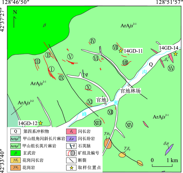
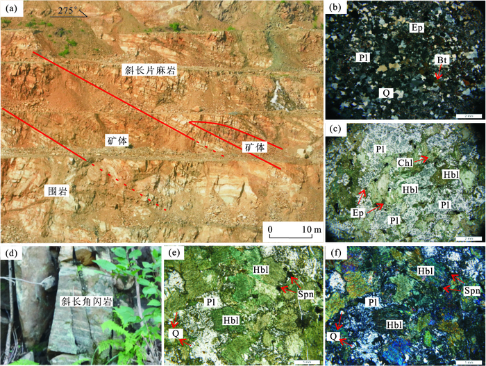
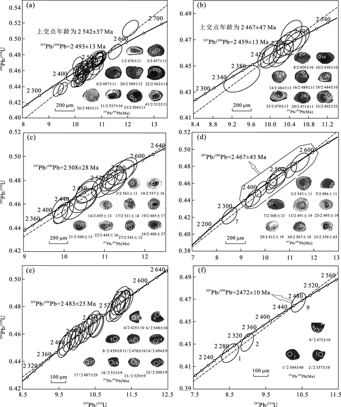
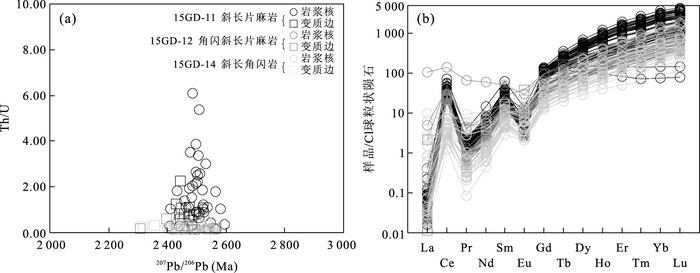
2017, 42(12): 2208-2228.
doi: 10.3799/dqkx.2017.611
Abstract:
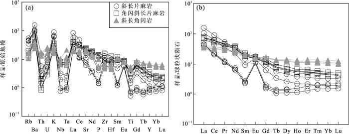
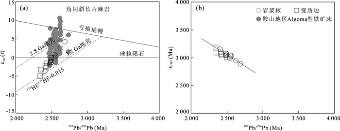
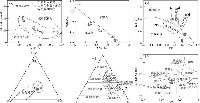
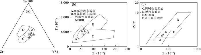
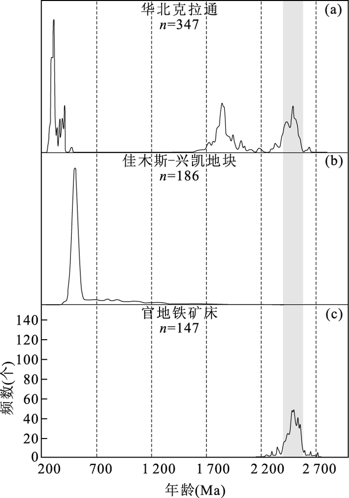
The Guandi iron deposit has been discovered and developed for several years and has been considered as a typical BIF-type iron deposit in Yanbian area, Northeast China. This deposit is located at the north part of the Helong massif, at the joint of the North China craton and the Xing'an-Mongolia orogenic belt. The stratiform and lenticular iron orebodies are dominantly hosted within the metamorphic rocks of Jiashan Formation, Anshan Group. In order to determine the formation age, metamorphic age and tectonic setting of the Guandi deposit, in this paper, the geochemistry, LA-ICP-MS zircon U-Pb dating and zircon Hf isotope for the ore-hosting plagiogneiss, amphibole plagiogneiss and amphibolite were conducted. The results indicate that the protolith of the plagiogneiss is rhyodacite and dacite pyroclastic rock, the protolith of the amphibole plagiogneiss is andesite, the protolith of the amphibolite is basalt. The LA-ICP-MS zircon U-Pb dating data imply that the Guandi area experienced the late Neoarchean to early Paleoproterozoic magmatic event (ca. 2 508~2 483 Ma) and metamorphic event (ca. 2 472~2 459 Ma), both of which have closely genetic relationship with the iron formation of the Guandi iron deposit. Geochemical characteristics of the ore-hosting amphibolite indicate that they formed in the back-arc basin setting, which is also interpreted as the tectonic setting of the Guandi iron deposit. The εHf(t) values of zircon grains from amphibole plagiogneiss range from -5.0 to +4.2, and the corresponding two-stage Hf model ages (tDM2) are from 3 182 Ma to 2 889 Ma, both of which indicate that the initial magma was mainly derived from the partial melting of the Mesoarchean crust. On the basis of comparison with several representative banded iron formations (BIFs) at home and abroad, it can be concluded that the Guandi iron deposit belongs to the Algoma-type BIFs, and was caused by the late Neoarchean large-scale BIF metallogenic event, which were widely developed in the North China craton. The Guandi area took place a crustal growth event at the early Neoarchean (2.8-2.7 Ga). Moreover, this paper proposes that the Helong massif has affinities to the North China Craton, which provides new evidence for the eastward termination of the Solonker-Xar Moron-Changchun suture in the Yanbian area.
The Guandi iron deposit has been discovered and developed for several years and has been considered as a typical BIF-type iron deposit in Yanbian area, Northeast China. This deposit is located at the north part of the Helong massif, at the joint of the North China craton and the Xing'an-Mongolia orogenic belt. The stratiform and lenticular iron orebodies are dominantly hosted within the metamorphic rocks of Jiashan Formation, Anshan Group. In order to determine the formation age, metamorphic age and tectonic setting of the Guandi deposit, in this paper, the geochemistry, LA-ICP-MS zircon U-Pb dating and zircon Hf isotope for the ore-hosting plagiogneiss, amphibole plagiogneiss and amphibolite were conducted. The results indicate that the protolith of the plagiogneiss is rhyodacite and dacite pyroclastic rock, the protolith of the amphibole plagiogneiss is andesite, the protolith of the amphibolite is basalt. The LA-ICP-MS zircon U-Pb dating data imply that the Guandi area experienced the late Neoarchean to early Paleoproterozoic magmatic event (ca. 2 508~2 483 Ma) and metamorphic event (ca. 2 472~2 459 Ma), both of which have closely genetic relationship with the iron formation of the Guandi iron deposit. Geochemical characteristics of the ore-hosting amphibolite indicate that they formed in the back-arc basin setting, which is also interpreted as the tectonic setting of the Guandi iron deposit. The εHf(t) values of zircon grains from amphibole plagiogneiss range from -5.0 to +4.2, and the corresponding two-stage Hf model ages (tDM2) are from 3 182 Ma to 2 889 Ma, both of which indicate that the initial magma was mainly derived from the partial melting of the Mesoarchean crust. On the basis of comparison with several representative banded iron formations (BIFs) at home and abroad, it can be concluded that the Guandi iron deposit belongs to the Algoma-type BIFs, and was caused by the late Neoarchean large-scale BIF metallogenic event, which were widely developed in the North China craton. The Guandi area took place a crustal growth event at the early Neoarchean (2.8-2.7 Ga). Moreover, this paper proposes that the Helong massif has affinities to the North China Craton, which provides new evidence for the eastward termination of the Solonker-Xar Moron-Changchun suture in the Yanbian area.
2017, 42(12): 2229-2242.
doi: 10.3799/dqkx.2017.141
Abstract:
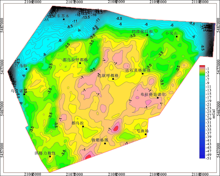
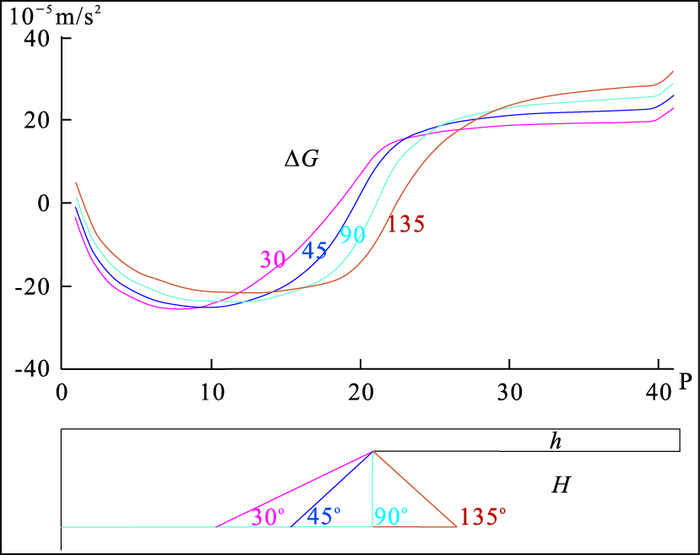
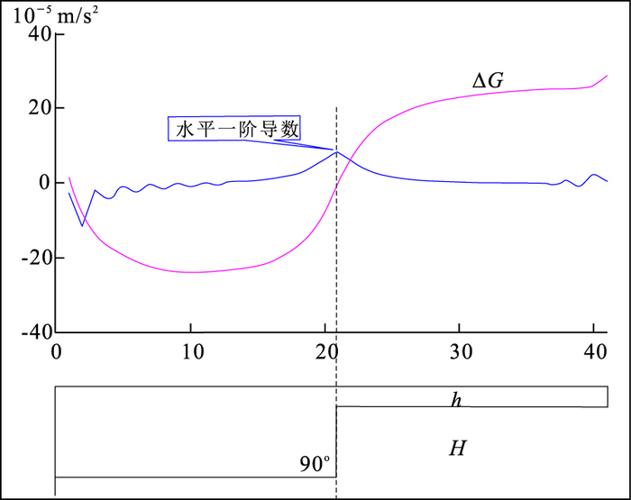
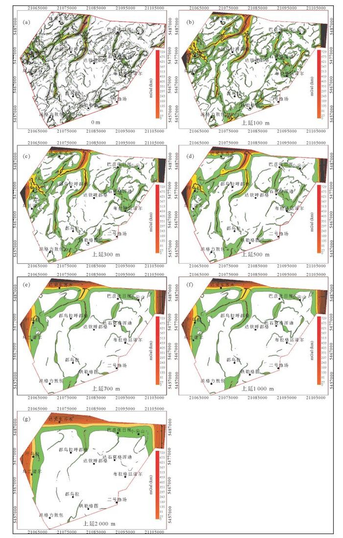
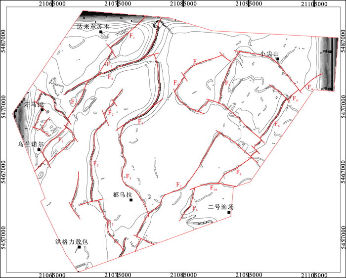
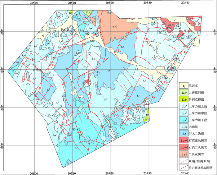
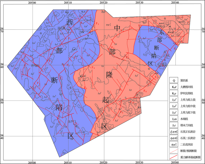
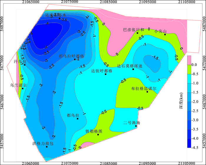
Characteristics of Bouguer gravity anomaly in the Lingquan basin indicate that lower gravity region on both sides of the basin is mainly the Jurassic-Cretaceous fault zone, the center is mainly a basement uplift. The upward continuation of the gravity anomaly is carried out, the results show that the upper surface of deep geological bodies has the characteristics of "east, west deep and center shallow"; the residual gravity anomaly also indicates that the local gravity of the central region mainly reflects the basement uplift, and the lower gravity of the eastern and western regions mainly reflects the fault of the Jurassic-Cretaceous. The basement faults of the Lingquan basin mainly are north and north-east, secondly is northwest, there are also early near north-south and east-west faults. The tectonic unit of the Lingquan basin is divided into the western fault zone, the central uplift zone and the eastern fault zone, we find that the Lingquan basin is actually an uplift rather than a graben basin, this is the result of tectonic inversion in the basin, other Mesozoic volcanic basins in the Erguna massif also have this model, and its basement is characterized by "shallow south deep north".
Characteristics of Bouguer gravity anomaly in the Lingquan basin indicate that lower gravity region on both sides of the basin is mainly the Jurassic-Cretaceous fault zone, the center is mainly a basement uplift. The upward continuation of the gravity anomaly is carried out, the results show that the upper surface of deep geological bodies has the characteristics of "east, west deep and center shallow"; the residual gravity anomaly also indicates that the local gravity of the central region mainly reflects the basement uplift, and the lower gravity of the eastern and western regions mainly reflects the fault of the Jurassic-Cretaceous. The basement faults of the Lingquan basin mainly are north and north-east, secondly is northwest, there are also early near north-south and east-west faults. The tectonic unit of the Lingquan basin is divided into the western fault zone, the central uplift zone and the eastern fault zone, we find that the Lingquan basin is actually an uplift rather than a graben basin, this is the result of tectonic inversion in the basin, other Mesozoic volcanic basins in the Erguna massif also have this model, and its basement is characterized by "shallow south deep north".

2017, 42(12): 2243-2257.
doi: 10.3799/dqkx.2017.142
Abstract:
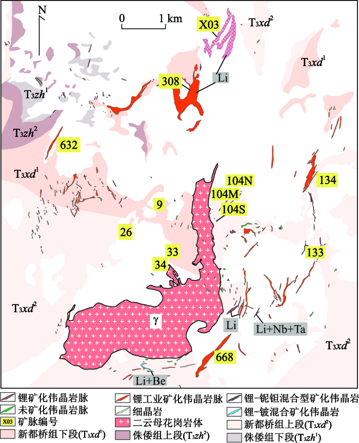
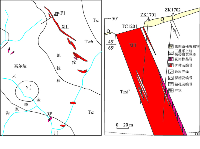
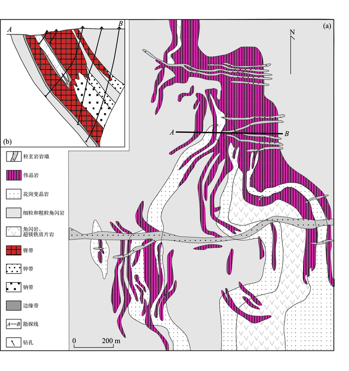
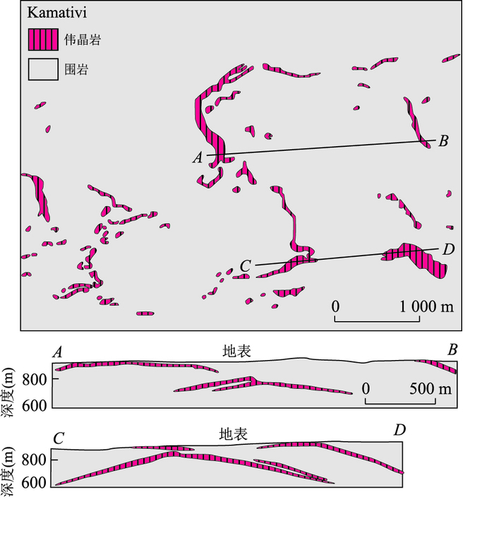
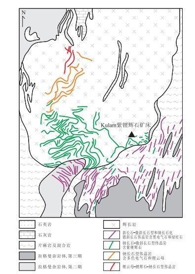
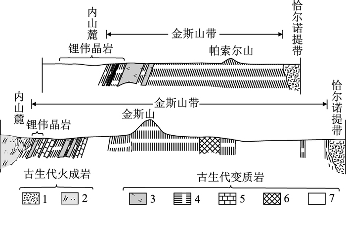
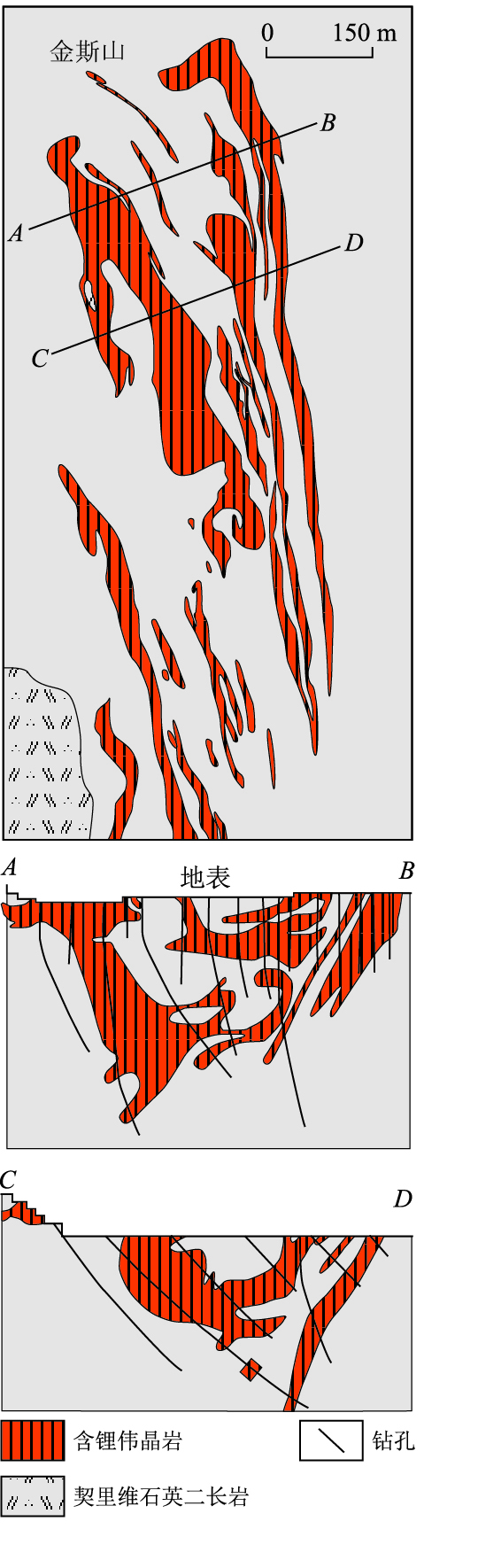
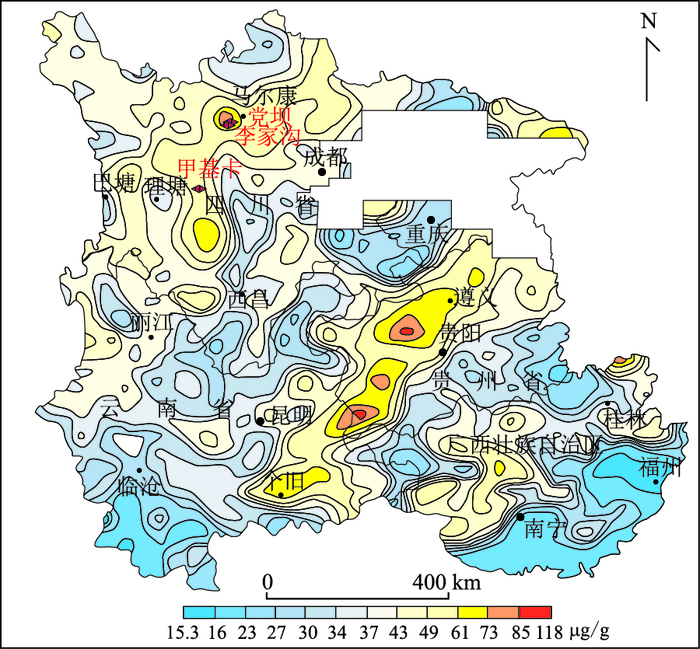
The spodumene deposit is an important type of lithium ore deposit, but it's prospecting has been discontinued because of its higher cost than salt lake in extracting lithium. Recently, the demand for lithium has multiplied due to the rapid development of emerging industries, and the recovery of spodumene has become an important source of lithium resources. This article summarizes some metallogenic characteristics of seven large and super-large spodumene deposits at home and abroad, and it is concluded that certain particularities are always associated with large-scale spodumene mineralization. For example, spodumene ore deposit of pegmatite type can be hosted within basic rocks instead of granite, gneiss, schist and other common host rocks. The size of spodumene grain can be either coarse or fine in the pegmatite. The zonality of pegmatite veins containing spodemene can be of good or not. The shape of the pegmatite veins can be simple or extremely complex. The metallogenic epoch can be old to the Archean or be new to the Cenozoic. The metallogenic tectonic environment can be a stable platform or an active Himalayan orogenic belt. In this paper, the prospecting direction of large and super-large spodumene deposits is discussed in terms of the particularity of the host rock, the mineralization epoch, the tectonic background and the mineralization zonality and so on. It points out that prospecting can neither be confined to the periphery of granite rock mass, nor taking the Greenbushes in Western Australian or the Tanco in North American located in old platform as the only case. It can't only think about the complexity of Xinjiang Koktokey, and oversight other super-large deposits whose size can be ten times in large deposits but in simple form such as the Jiajika and the Ke'eryin pegmatite fields in Sichuan. Also, it can not only consider the traditional geological method but also combine the actual situation to establish proper geophysical and geochemical prospecting models. As long as the specific problem is analyzed, the prospecting method is expanded, the exploration technique is used properly, it is completely possible to obtain a new prospecting breakthrough.
The spodumene deposit is an important type of lithium ore deposit, but it's prospecting has been discontinued because of its higher cost than salt lake in extracting lithium. Recently, the demand for lithium has multiplied due to the rapid development of emerging industries, and the recovery of spodumene has become an important source of lithium resources. This article summarizes some metallogenic characteristics of seven large and super-large spodumene deposits at home and abroad, and it is concluded that certain particularities are always associated with large-scale spodumene mineralization. For example, spodumene ore deposit of pegmatite type can be hosted within basic rocks instead of granite, gneiss, schist and other common host rocks. The size of spodumene grain can be either coarse or fine in the pegmatite. The zonality of pegmatite veins containing spodemene can be of good or not. The shape of the pegmatite veins can be simple or extremely complex. The metallogenic epoch can be old to the Archean or be new to the Cenozoic. The metallogenic tectonic environment can be a stable platform or an active Himalayan orogenic belt. In this paper, the prospecting direction of large and super-large spodumene deposits is discussed in terms of the particularity of the host rock, the mineralization epoch, the tectonic background and the mineralization zonality and so on. It points out that prospecting can neither be confined to the periphery of granite rock mass, nor taking the Greenbushes in Western Australian or the Tanco in North American located in old platform as the only case. It can't only think about the complexity of Xinjiang Koktokey, and oversight other super-large deposits whose size can be ten times in large deposits but in simple form such as the Jiajika and the Ke'eryin pegmatite fields in Sichuan. Also, it can not only consider the traditional geological method but also combine the actual situation to establish proper geophysical and geochemical prospecting models. As long as the specific problem is analyzed, the prospecting method is expanded, the exploration technique is used properly, it is completely possible to obtain a new prospecting breakthrough.

2017, 42(12): 2258-2275.
doi: 10.3799/dqkx.2017.614
Abstract:
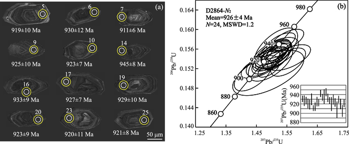
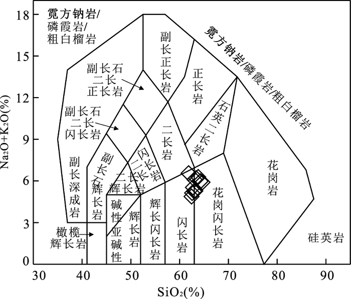
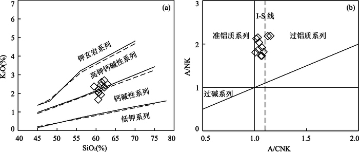
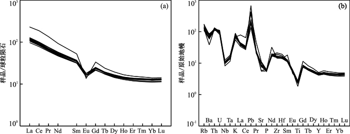
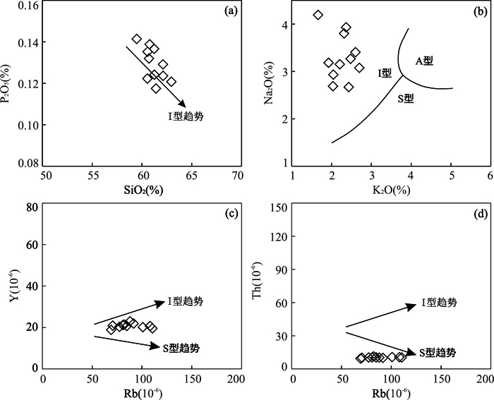
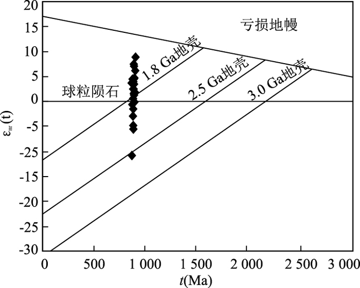
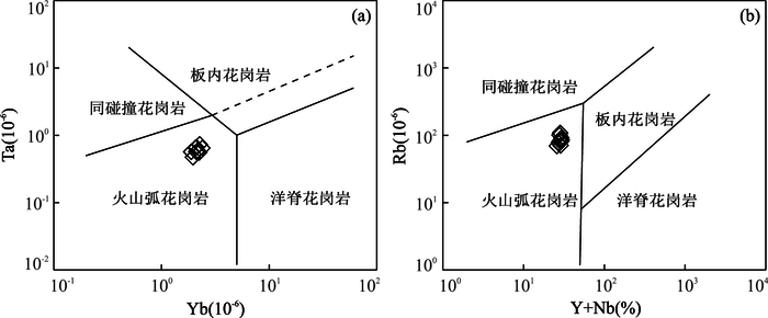
More geological researchers are focusing on the Neoproterozoic magmatic activities of Qilian Terrane and little chronological and geochemical materials are about the North Liuhuangkuang Granodiorites (NLG) in the western segment of Qilian Terrane.The zircons of rock samples which havedistinct rhythmic growth zoning are long cylindrical and euhedral well, implying the features of magmatic origin. The resultsof dating indicate that the rocks were formed in the Early Neoproterozoic (926±4 Ma).11 samples' new whole-rock geochemical analysis results have SiO2 content of 59.47%~62.96%, P2O5 content of 0.12%~0.14% with A/CNK values of 1.01~1.15, which showed that the NLG were high-K calc-alkaline with characteristics of I-type. The ∑REE content was between 118.80×10⁻⁶ and 253.07×10⁻⁶, with (La/Yb)N ratio of 7.87~16.17 and δEu (0.89~1.03). The REE diagram showed rightward incline and mid-negative weekly negative Eu abnormity. The NLG were enriched in large-ion lithophile elements:Rb, Th, U, LREE and depleted in high field strength elements:Nb, Ta, Ti, P. The ratios of Nb/Ta, La/Nb, Nb/U and Sm/Nd show crustal characteristics. The Hf isotopes showed that the εHf(t) of NLG mainly ranged from 0 to 7 and its crustal model ages were between 1 247 Ma and 1 801 Ma. With the regional magmatic activities, the NLG probably were formed in a subduction tectonic environment of continental margin arc and it suggested that the primary magma was derived from the remelting of juvenile crustal materials in Mesoproterozic, experiencinga certain extent of fractional crystallization. Otherwise, the melting of the ancient crust also probably participated the formation of the NLG. The NLG magma activities may the response of the converge of the Rodinia Supercontinental, during the Neoproterozoic, which provided the attribute of the Qilian Terrane with credible research materials.
More geological researchers are focusing on the Neoproterozoic magmatic activities of Qilian Terrane and little chronological and geochemical materials are about the North Liuhuangkuang Granodiorites (NLG) in the western segment of Qilian Terrane.The zircons of rock samples which havedistinct rhythmic growth zoning are long cylindrical and euhedral well, implying the features of magmatic origin. The resultsof dating indicate that the rocks were formed in the Early Neoproterozoic (926±4 Ma).11 samples' new whole-rock geochemical analysis results have SiO2 content of 59.47%~62.96%, P2O5 content of 0.12%~0.14% with A/CNK values of 1.01~1.15, which showed that the NLG were high-K calc-alkaline with characteristics of I-type. The ∑REE content was between 118.80×10⁻⁶ and 253.07×10⁻⁶, with (La/Yb)N ratio of 7.87~16.17 and δEu (0.89~1.03). The REE diagram showed rightward incline and mid-negative weekly negative Eu abnormity. The NLG were enriched in large-ion lithophile elements:Rb, Th, U, LREE and depleted in high field strength elements:Nb, Ta, Ti, P. The ratios of Nb/Ta, La/Nb, Nb/U and Sm/Nd show crustal characteristics. The Hf isotopes showed that the εHf(t) of NLG mainly ranged from 0 to 7 and its crustal model ages were between 1 247 Ma and 1 801 Ma. With the regional magmatic activities, the NLG probably were formed in a subduction tectonic environment of continental margin arc and it suggested that the primary magma was derived from the remelting of juvenile crustal materials in Mesoproterozic, experiencinga certain extent of fractional crystallization. Otherwise, the melting of the ancient crust also probably participated the formation of the NLG. The NLG magma activities may the response of the converge of the Rodinia Supercontinental, during the Neoproterozoic, which provided the attribute of the Qilian Terrane with credible research materials.
2017, 42(12): 2276-2281.
doi: 10.3799/dqkx.2017.584
Abstract:
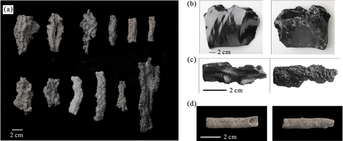
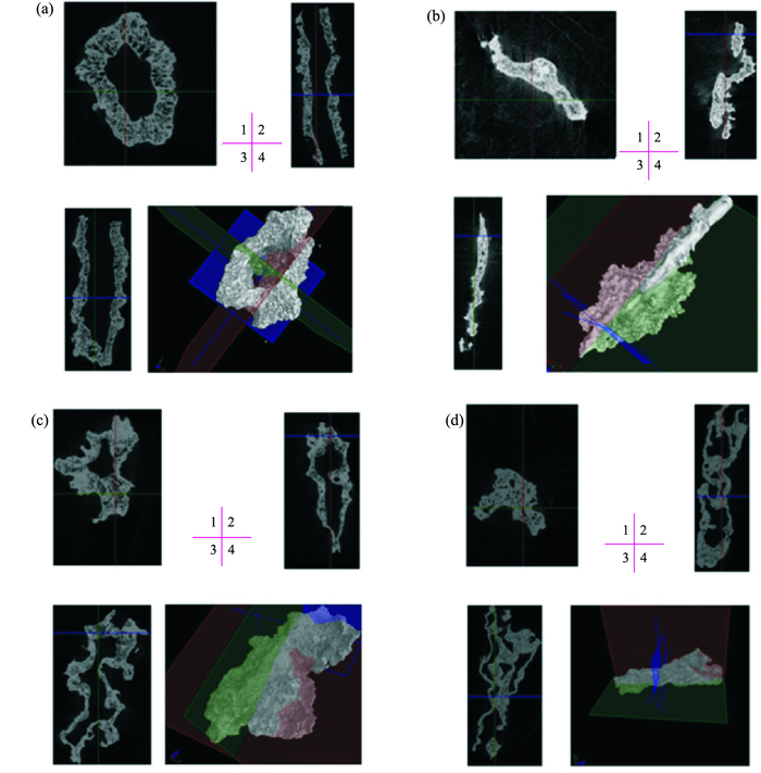
Fulgurites are natural glass material which is formed when lightning strikes and melts the ground and the super high temperature fuses and vitrifies mineral grains. The fulgurite was seldom studied in China due to the rareness of the specimens. By using several new technologies such as CT scanning, 3-D reconstruction of the interior structure and electron probe microanalysis, the results reveal the detailed morphology of both the external and interior structures of the fulgurite as well as its mineral composition. Its external surface is complex and coarse while the internal surface is bright and different from the internal surface in color. The internal surface is full of foramina, and can be classed into three types:fully run-through, partially closed, and completely closed. The fulgurite has the dominant composition of SiO2, with only small proportion of other metal elements. It also was compared with volcanic glass and tektite and determined that a tubular structured stone from Inner Mongolia is not fulgurite. This paper provides some basic data for future study and application of the fulgurite.
Fulgurites are natural glass material which is formed when lightning strikes and melts the ground and the super high temperature fuses and vitrifies mineral grains. The fulgurite was seldom studied in China due to the rareness of the specimens. By using several new technologies such as CT scanning, 3-D reconstruction of the interior structure and electron probe microanalysis, the results reveal the detailed morphology of both the external and interior structures of the fulgurite as well as its mineral composition. Its external surface is complex and coarse while the internal surface is bright and different from the internal surface in color. The internal surface is full of foramina, and can be classed into three types:fully run-through, partially closed, and completely closed. The fulgurite has the dominant composition of SiO2, with only small proportion of other metal elements. It also was compared with volcanic glass and tektite and determined that a tubular structured stone from Inner Mongolia is not fulgurite. This paper provides some basic data for future study and application of the fulgurite.
2017, 42(12): 2282-2298.
doi: 10.3799/dqkx.2017.143
Abstract:
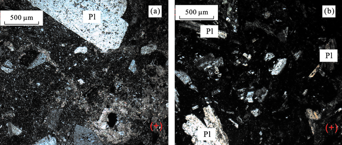
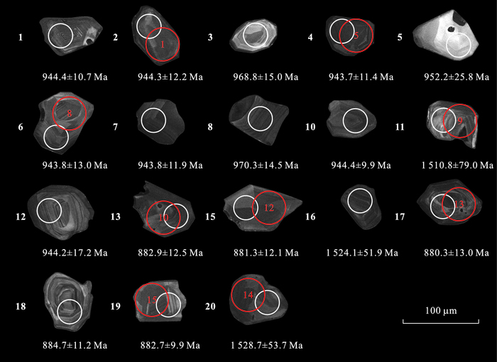
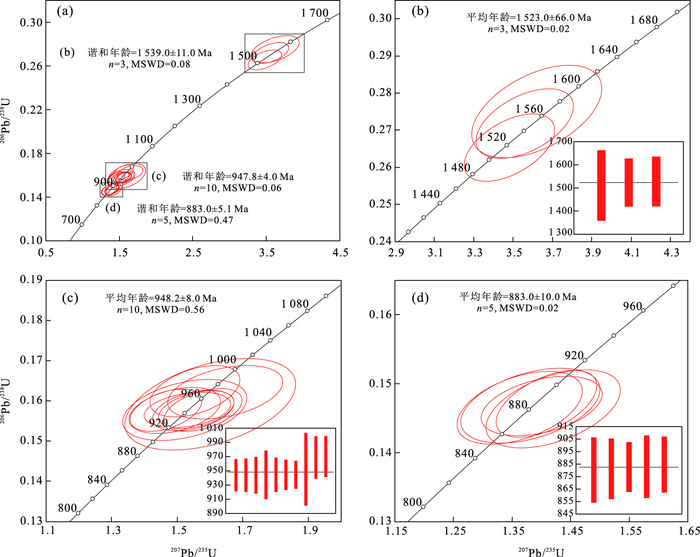
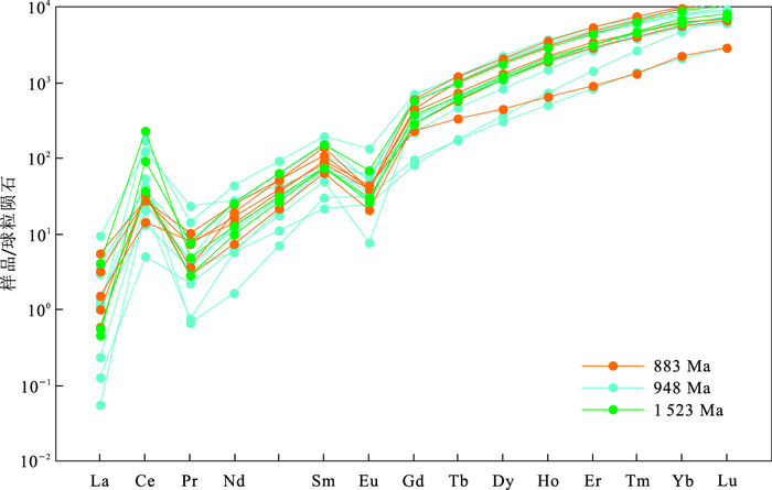
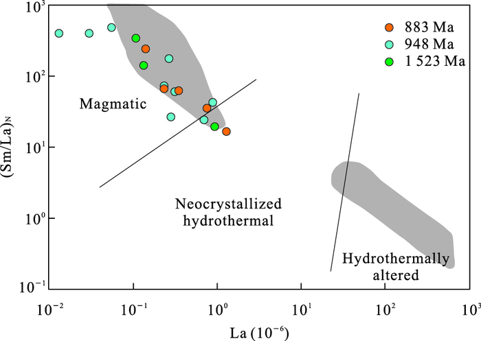
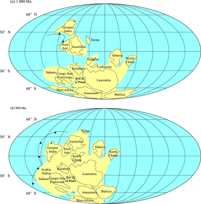
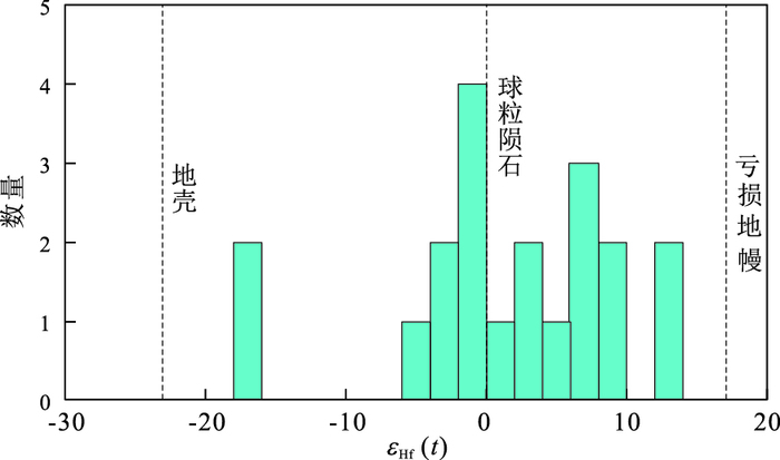
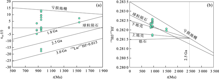
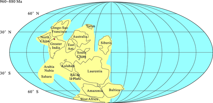
This is a hotpoint that the study the breakup of Rodinia supercontinent and the formation of Chiniot iron oxide-apatite deposit, we report zircon U-Pb ages, Hf isotopic composition and REE contents of andesite. All the zircons are magmatic origin with the similar REE patterns which are enriched in HREE with a positive Ce anomaly and a negative Eu anomaly. The zircon U-Pb isotopic analyses yields 206Pb/238U ages of 947.8±4.0 Ma and 883.0±5.1 Ma, which can be interpreted as the crystallization ages of two stages of andesites. Besides, the inherited zircons with U-Pb age of 1 523.0±66 Ma may indicate a Mesoproterozoic basement. The igneous zircons have highly variable εHf(t) values ranging from -4.67 to +13.10, indicating that the andesites were derived from partial melting of a mixed mantle sourse. The geochemical and isotopic variation suggest that mantle-derived basic magmas have went through some degree of crustal commination during migration through Mesoproterozoic granitoids. The formation of the andesites were induced by a series of tectono-thermal events, associated with extensional rift and mantle plume during Rodinia supercontinent. There are many similarities between Chiniotiron deposit and Khetri Copper Belt in geological setting of ore-forming processes, indicating that the metallogenetic potentiality of giant IOCG is very well. The northwest of Indian craton may have connection with North China-Congo-São Francisco craton between 960 Ma and 880 Ma.
This is a hotpoint that the study the breakup of Rodinia supercontinent and the formation of Chiniot iron oxide-apatite deposit, we report zircon U-Pb ages, Hf isotopic composition and REE contents of andesite. All the zircons are magmatic origin with the similar REE patterns which are enriched in HREE with a positive Ce anomaly and a negative Eu anomaly. The zircon U-Pb isotopic analyses yields 206Pb/238U ages of 947.8±4.0 Ma and 883.0±5.1 Ma, which can be interpreted as the crystallization ages of two stages of andesites. Besides, the inherited zircons with U-Pb age of 1 523.0±66 Ma may indicate a Mesoproterozoic basement. The igneous zircons have highly variable εHf(t) values ranging from -4.67 to +13.10, indicating that the andesites were derived from partial melting of a mixed mantle sourse. The geochemical and isotopic variation suggest that mantle-derived basic magmas have went through some degree of crustal commination during migration through Mesoproterozoic granitoids. The formation of the andesites were induced by a series of tectono-thermal events, associated with extensional rift and mantle plume during Rodinia supercontinent. There are many similarities between Chiniotiron deposit and Khetri Copper Belt in geological setting of ore-forming processes, indicating that the metallogenetic potentiality of giant IOCG is very well. The northwest of Indian craton may have connection with North China-Congo-São Francisco craton between 960 Ma and 880 Ma.
2017, 42(12): 2299-2311.
doi: 10.3799/dqkx.2017.571
Abstract:
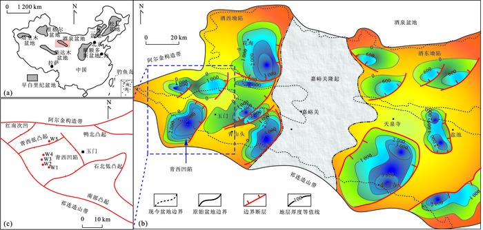
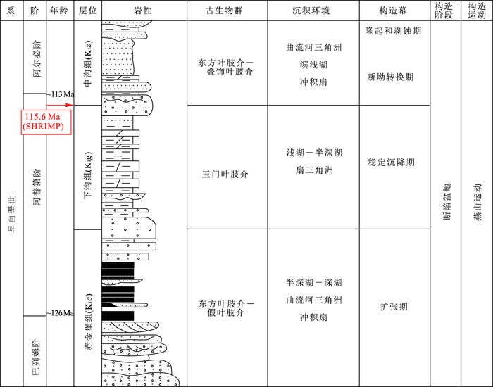
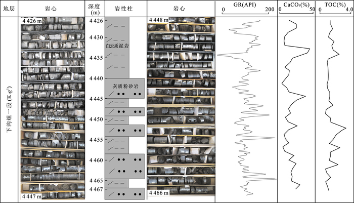
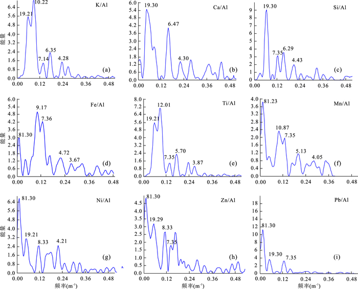
The high resolution geochemical data are used as important proxies in cyclostratigraphy, which cost a lot of time and money to obtain the data in the usual way (ICP-MS or WD-XRF). And the handheld energy-dispersive X-ray fluorescence (ED-XRF) can obtain the high resolution geochemical data efficiently. Currently, the handheld energy-dispersive X-ray fluorescence (ED-XRF) was few used in the study of sedimentary strata, especially in cyclostratigraphy research field.Continuous core samples of deep lacustrine mudstone and dolomitic mudstone were selected from the Xiagou Formation of the Lower Cretaceous in the Qingxi Sag, Jiuquan Basin. Content of 24 major elements and trace elements which can be used as important proxies in cyclostratigraphy were accurately measured under the Handheld energy-dispersive X-ray fluorescence (ED-XRF) testing, a non-destructive, direct method with high precision in an efficiency way which can test one single sample in five minutes. Ratios of obtained geochemical data (K/Al, Ca/Al, Si/Al, Fe/Al, Ti/Al, Mn/Al, Ni/Al, Zn/Al and Pb/Al) were analyzed by spectral methods further. Such results presented cycle wavelengths in the stratigraphic units show a value of 20.25:4.75:1.75:1.00, corresponding with those of Milankovitch cycle periods (400 ka (long eccentricity):95 ka (short eccentricity):37 ka (obliquity):20 ka (precession), respectively) in Well W2. The correspondences between the sedimentary cycle ratios and the Milankovitch cycle periods indicates controlling effect of astronomical factors on sedimentation. ED-XRF provide the new possibilities in detection and quantification of geological processes, and have great significance in establishing geological time series.
The high resolution geochemical data are used as important proxies in cyclostratigraphy, which cost a lot of time and money to obtain the data in the usual way (ICP-MS or WD-XRF). And the handheld energy-dispersive X-ray fluorescence (ED-XRF) can obtain the high resolution geochemical data efficiently. Currently, the handheld energy-dispersive X-ray fluorescence (ED-XRF) was few used in the study of sedimentary strata, especially in cyclostratigraphy research field.Continuous core samples of deep lacustrine mudstone and dolomitic mudstone were selected from the Xiagou Formation of the Lower Cretaceous in the Qingxi Sag, Jiuquan Basin. Content of 24 major elements and trace elements which can be used as important proxies in cyclostratigraphy were accurately measured under the Handheld energy-dispersive X-ray fluorescence (ED-XRF) testing, a non-destructive, direct method with high precision in an efficiency way which can test one single sample in five minutes. Ratios of obtained geochemical data (K/Al, Ca/Al, Si/Al, Fe/Al, Ti/Al, Mn/Al, Ni/Al, Zn/Al and Pb/Al) were analyzed by spectral methods further. Such results presented cycle wavelengths in the stratigraphic units show a value of 20.25:4.75:1.75:1.00, corresponding with those of Milankovitch cycle periods (400 ka (long eccentricity):95 ka (short eccentricity):37 ka (obliquity):20 ka (precession), respectively) in Well W2. The correspondences between the sedimentary cycle ratios and the Milankovitch cycle periods indicates controlling effect of astronomical factors on sedimentation. ED-XRF provide the new possibilities in detection and quantification of geological processes, and have great significance in establishing geological time series.


2017, 42(12): 2312-2326.
doi: 10.3799/dqkx.2017.144
Abstract:
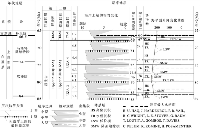
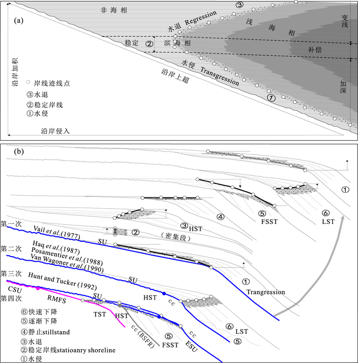
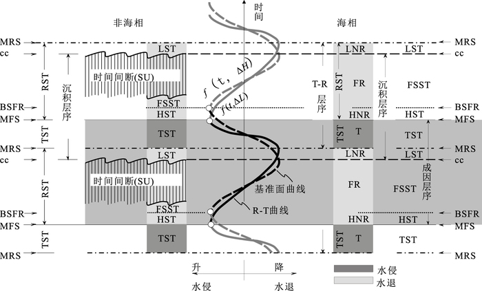
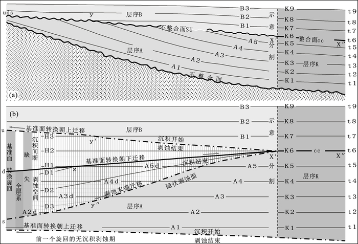
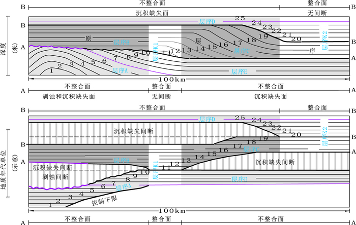
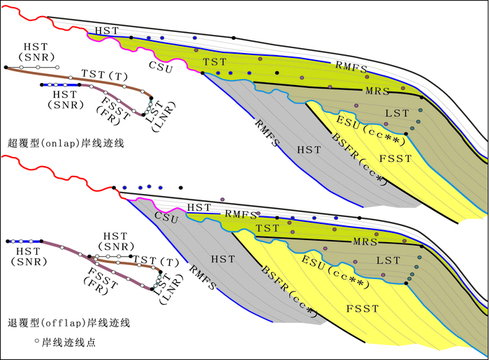
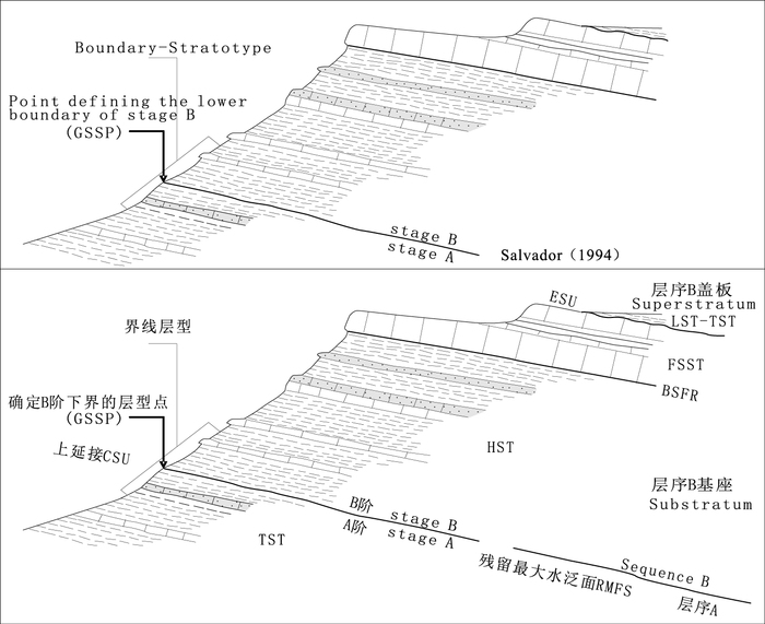
This article reviews contributions and influences of seismic stratigraphy to sequence stratigraphy, and theoretical accumulations of sequence stratigraphy; and points four problems as followings:sequence boundaries (subaerial unconformities and their correlative conformies) spanning boundaries of Erathem, System, Series and Stage; "transgressive-regressive" cycles as base of original sequence stratigraphic models inducing to adjust sequence boundaries at least three times, base-level curve delaying transgressive-regressive (T-R) curve, and the purely geometric correlative conformity (c.c) obstructing theoretically sequence stratigraphy. Meanwhile this paper points four aspects as followings. (1) Stillstand normal regression (SNR) replacing highstand normal regression is used to avoid the non-periodicity hiding in sequence stratigraphy due to the unreasonable design of highstand normal regression. (2) Based on the character of remnant maximum flooding surfaces potentially closed to or in accord with the boundaries of chronostratigraphic units or even the lower boundaries of stage (GSSP), sequence stratigraphy is necessary to establish compound sequence boundary composed of remnant maximum flooding surfaces (RMFS) and their correlative unconformities (CSU), and to use the RMFS component to solve the problem that current sequence boundaries have been spanning the boundaries of chronostratigraphic units. (3) It may be applied the one-to-one tracing style (one RMFR to one CSU) from basin to land in compound sequence boundary to the problem that current sequence boundaries have been adjusted many times, i.e., they were placed to base of T-R, base of lowstand systems tract in three-divided model or base surface of forced regression, and top of forced regressive wedge systems tract, due to one-to-many tracing style (one subarial unconformity to many potential correlative conformities) from basin to land in existing sequence stratigraphic models. (4) The term "correlative unconformity" should be reduced to a lower rank as boundary of systems tract so as to solve the problem about "doubly defined correlative conformities" in existing sequence stratigraphic models. Respectively, Hunt and Tucker (1992)'s correlative conformity is replaced by extension of subarial unconformity (ESU) from correlative subaerial unconformity component of compound sequence boundary, and is as base of lowstand systems tract and partially as subarial unconformable base of transgressive systems tract; whereas, Posamentier and Allen (1999)'s correlative conformity is replaced by the resumed term basal surface of forced regression (BSFR) above compound sequence boundary, and is as base of falling stage systems tract. Moreover, regressive surface of marine erosion (RSME) as the synonymous term for basal surface of forced regression does not completely represent marine and nonmarine settings.
This article reviews contributions and influences of seismic stratigraphy to sequence stratigraphy, and theoretical accumulations of sequence stratigraphy; and points four problems as followings:sequence boundaries (subaerial unconformities and their correlative conformies) spanning boundaries of Erathem, System, Series and Stage; "transgressive-regressive" cycles as base of original sequence stratigraphic models inducing to adjust sequence boundaries at least three times, base-level curve delaying transgressive-regressive (T-R) curve, and the purely geometric correlative conformity (c.c) obstructing theoretically sequence stratigraphy. Meanwhile this paper points four aspects as followings. (1) Stillstand normal regression (SNR) replacing highstand normal regression is used to avoid the non-periodicity hiding in sequence stratigraphy due to the unreasonable design of highstand normal regression. (2) Based on the character of remnant maximum flooding surfaces potentially closed to or in accord with the boundaries of chronostratigraphic units or even the lower boundaries of stage (GSSP), sequence stratigraphy is necessary to establish compound sequence boundary composed of remnant maximum flooding surfaces (RMFS) and their correlative unconformities (CSU), and to use the RMFS component to solve the problem that current sequence boundaries have been spanning the boundaries of chronostratigraphic units. (3) It may be applied the one-to-one tracing style (one RMFR to one CSU) from basin to land in compound sequence boundary to the problem that current sequence boundaries have been adjusted many times, i.e., they were placed to base of T-R, base of lowstand systems tract in three-divided model or base surface of forced regression, and top of forced regressive wedge systems tract, due to one-to-many tracing style (one subarial unconformity to many potential correlative conformities) from basin to land in existing sequence stratigraphic models. (4) The term "correlative unconformity" should be reduced to a lower rank as boundary of systems tract so as to solve the problem about "doubly defined correlative conformities" in existing sequence stratigraphic models. Respectively, Hunt and Tucker (1992)'s correlative conformity is replaced by extension of subarial unconformity (ESU) from correlative subaerial unconformity component of compound sequence boundary, and is as base of lowstand systems tract and partially as subarial unconformable base of transgressive systems tract; whereas, Posamentier and Allen (1999)'s correlative conformity is replaced by the resumed term basal surface of forced regression (BSFR) above compound sequence boundary, and is as base of falling stage systems tract. Moreover, regressive surface of marine erosion (RSME) as the synonymous term for basal surface of forced regression does not completely represent marine and nonmarine settings.
2017, 42(12): 2327-2335.
doi: 10.3799/dqkx.2017.145
Abstract:
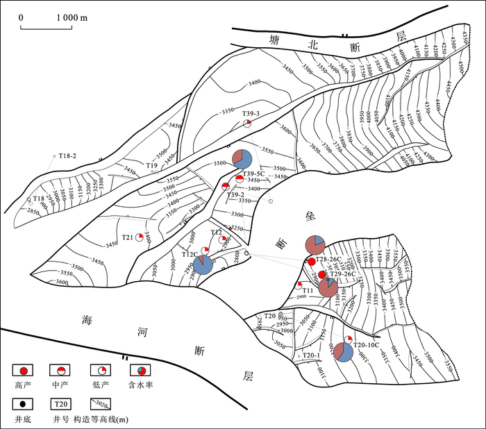
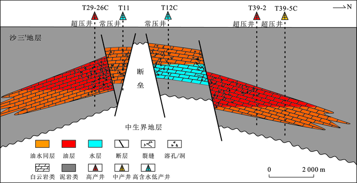
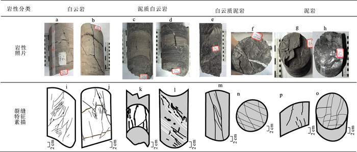
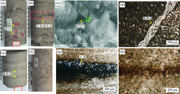
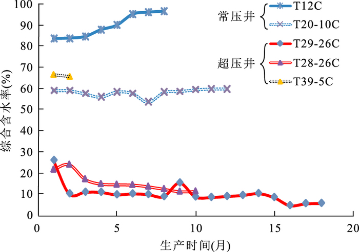
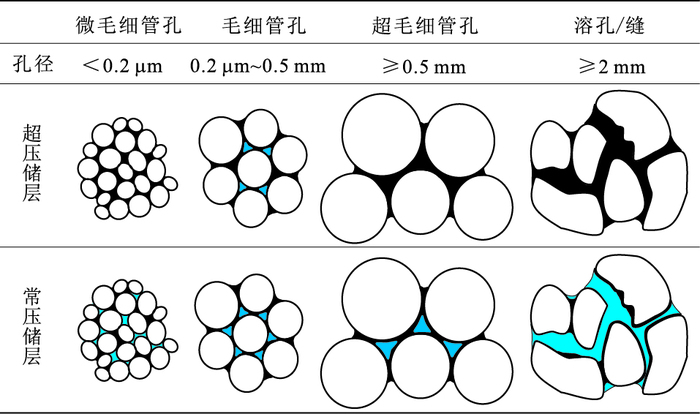
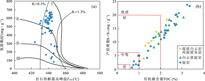
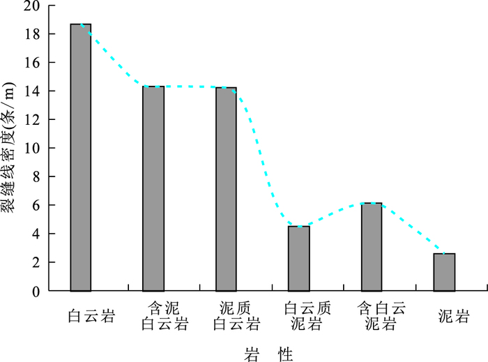
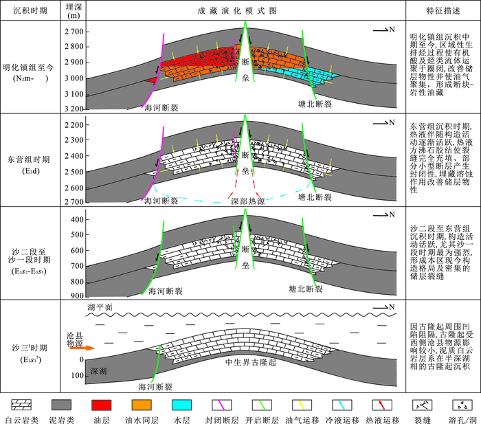
Lacustrine argillaceous dolomite reservoir has been found the Ⅲ-5 Member of Shahejie Formation, Tanggu District, Bohai Bay Basin, China, which buried depth is 2 800-3 600 m and keeps oil in the fault block-lithologic argillaceous dolomite reservoir. Considering structure and sedimentary background, the research summarizes reservoir characteristics mainly includes lithologic character, reservoir property and hydrocarbon distribution. At the same time, the paper provides the controlling factors and pattern of hydrocarbon accumulation through integrated analysis of source-reservoir-seal combination and evolution of tectonics, diagenesis and hydrocarbon accumulation. The results show that reservoir lithologic is mainly dolomite and argillaceous dolomite and belongs to fracture-pore reservoir of ultra low porosity and permeability, whose reservoir space, to a large extent, includes intercrystalline pore, secondary dissolved pore, dissolved fractures and fractures. Overpressure is closely correlated with the hydrocarbon distribution. The overpressure wells show medium-high production and their water cuts are under 20% with a continuing downward trend; while instead, the normal wells show low production and water cuts are above 55% owning a smooth or upward trend. Mudstone is high-quality source rocks and can supply enough oil to dolomite reservoir. The quantity of hydrocarbon generation and reserves capacity of dolomite are both closely relevant to abundant algae laminae. Fault sealing controls the hydrocarbon accumulation and distribution of overpressure, whose one of the main driving force is hydrocarbon generation. The overpressure has been the significant mark of hydrocarbon enrichment. The hydrocarbon-charging time is behind the fault sealing, thus hydrocarbon-charging is effective.
Lacustrine argillaceous dolomite reservoir has been found the Ⅲ-5 Member of Shahejie Formation, Tanggu District, Bohai Bay Basin, China, which buried depth is 2 800-3 600 m and keeps oil in the fault block-lithologic argillaceous dolomite reservoir. Considering structure and sedimentary background, the research summarizes reservoir characteristics mainly includes lithologic character, reservoir property and hydrocarbon distribution. At the same time, the paper provides the controlling factors and pattern of hydrocarbon accumulation through integrated analysis of source-reservoir-seal combination and evolution of tectonics, diagenesis and hydrocarbon accumulation. The results show that reservoir lithologic is mainly dolomite and argillaceous dolomite and belongs to fracture-pore reservoir of ultra low porosity and permeability, whose reservoir space, to a large extent, includes intercrystalline pore, secondary dissolved pore, dissolved fractures and fractures. Overpressure is closely correlated with the hydrocarbon distribution. The overpressure wells show medium-high production and their water cuts are under 20% with a continuing downward trend; while instead, the normal wells show low production and water cuts are above 55% owning a smooth or upward trend. Mudstone is high-quality source rocks and can supply enough oil to dolomite reservoir. The quantity of hydrocarbon generation and reserves capacity of dolomite are both closely relevant to abundant algae laminae. Fault sealing controls the hydrocarbon accumulation and distribution of overpressure, whose one of the main driving force is hydrocarbon generation. The overpressure has been the significant mark of hydrocarbon enrichment. The hydrocarbon-charging time is behind the fault sealing, thus hydrocarbon-charging is effective.
2017, 42(12): 2336-2344.
doi: 10.3799/dqkx.2017.567
Abstract:
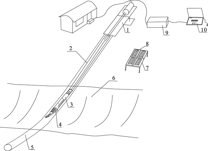
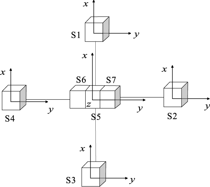
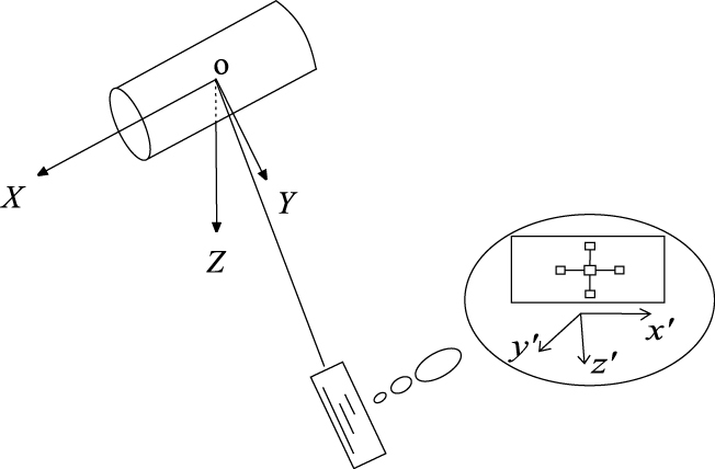
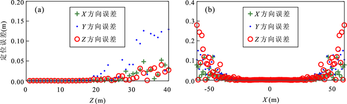
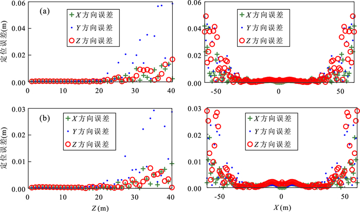
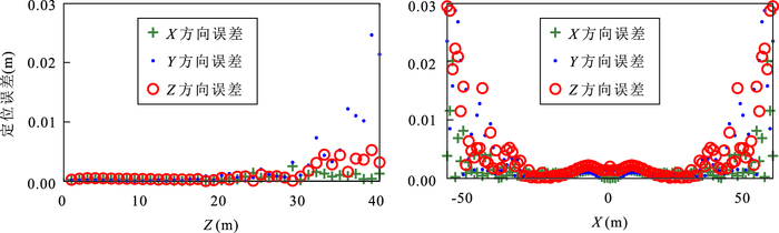
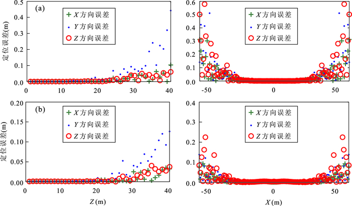
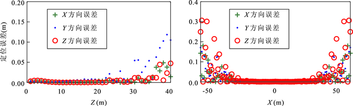
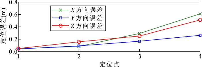
Determining the dynamic position of the drill bit is the key to the successful implementation of horizontal directional drilling (HDD). To improve the accuracy and the scope of application of HDD positioning technology, a new method is proposed to detect the position of the drill bit. A cylindrical permanent magnet with 50 mm in diameter and 300 mm height is placed on the ground as a magnetic beacon and the magnet axis is parallel to the horizontal plane. A sensors array which consists of five tri-axial magnetometers, a tri-axial accelerometer and a tri-axial gyroscope is attached to the bottom hole assembly and measures the magnetic gradient tensor of the magnetic beacon. Then, the position of the drill bit can be solved by the localization algorithm based on magnetic gradient tensor. The simulation analysis shows that. The simulation analysis shows that this method has high positioning accuracy in vertical direction and horizontal direction, and the position errors can be controlled within 1% through adjusting the beacon position, the number of the permanent magnets, the sensitive of magnetometers and the baseline distance. Besides, in the limited space of drilling tools, the longer the baseline is, the higher the position accuracy is. The outdoor experiment demonstrate that this method totally avoids the impact of the environmental magnetic field and has good practical effect. Conclusion can be made that this new method can be applied in trenchless HDD positioning with better effect and wider application range than other methods.
Determining the dynamic position of the drill bit is the key to the successful implementation of horizontal directional drilling (HDD). To improve the accuracy and the scope of application of HDD positioning technology, a new method is proposed to detect the position of the drill bit. A cylindrical permanent magnet with 50 mm in diameter and 300 mm height is placed on the ground as a magnetic beacon and the magnet axis is parallel to the horizontal plane. A sensors array which consists of five tri-axial magnetometers, a tri-axial accelerometer and a tri-axial gyroscope is attached to the bottom hole assembly and measures the magnetic gradient tensor of the magnetic beacon. Then, the position of the drill bit can be solved by the localization algorithm based on magnetic gradient tensor. The simulation analysis shows that. The simulation analysis shows that this method has high positioning accuracy in vertical direction and horizontal direction, and the position errors can be controlled within 1% through adjusting the beacon position, the number of the permanent magnets, the sensitive of magnetometers and the baseline distance. Besides, in the limited space of drilling tools, the longer the baseline is, the higher the position accuracy is. The outdoor experiment demonstrate that this method totally avoids the impact of the environmental magnetic field and has good practical effect. Conclusion can be made that this new method can be applied in trenchless HDD positioning with better effect and wider application range than other methods.
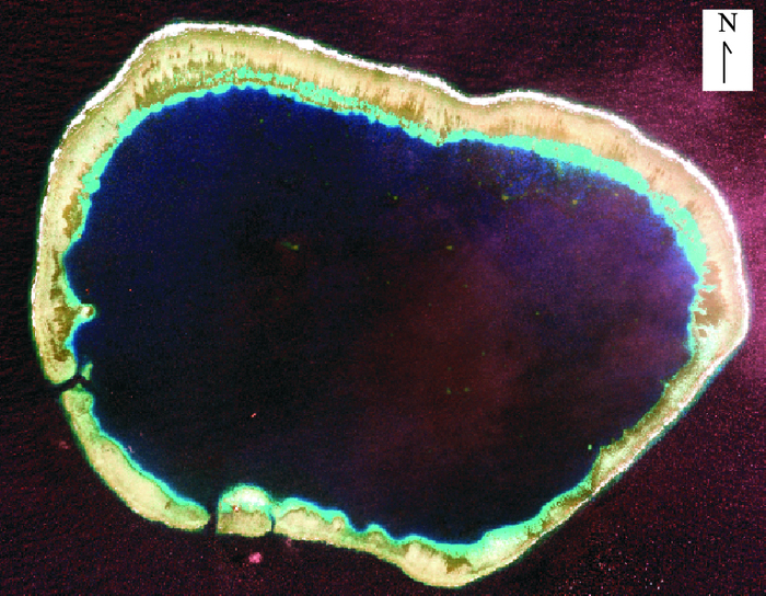
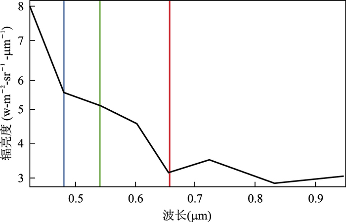
2017, 42(12): 2345-2353.
doi: 10.3799/dqkx.2017.552
Abstract:
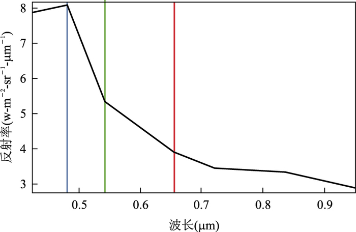
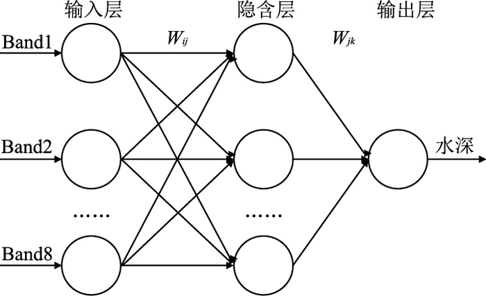
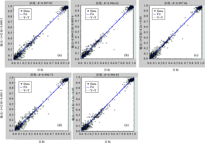
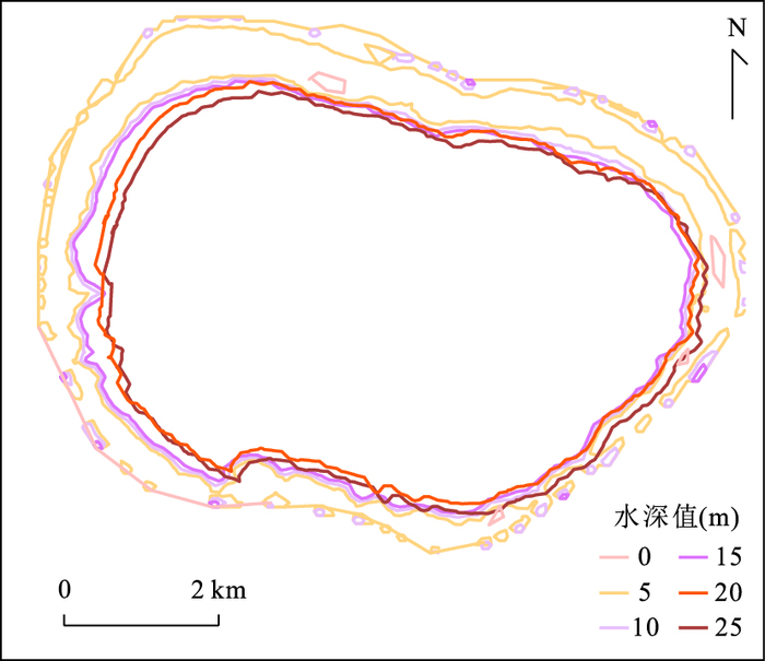
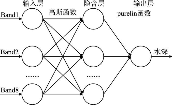
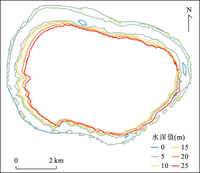
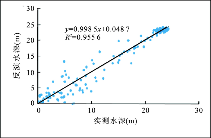
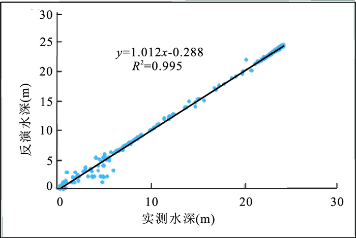
The inversion of water depth from remote sensing imagery is an important technology of depth measurement. In this paper, on the basis of radiometric calibration and atmospheric correction, BP(back propagation)and RBF(radial basis function) neural networks were built to retrieve water depth from WorldView-02 high-resolution satellite imagery in Mischief reef. Band 1 to band 8 of satellite imagery were used as the input data of the neural networks. Then, they were converted from input layer to hidden layer and from the hidden layer to output layer with tansig, logsig, Gaussian and purelin functions. Finally, the accuracy of the two models was evaluated by R2 (coefficient of determination), MAE(mean absolute error), RMSE(root mean square error) and the regression analysis between retrieved water depth and ground measured water depth. The results show that RBF neural network has simpler model structure, and lower requirement of samples. Besides, its retrieval accuracy reaches 0.995. Therefore, RBF neural network is more suitable for the inversion of water depth.
The inversion of water depth from remote sensing imagery is an important technology of depth measurement. In this paper, on the basis of radiometric calibration and atmospheric correction, BP(back propagation)and RBF(radial basis function) neural networks were built to retrieve water depth from WorldView-02 high-resolution satellite imagery in Mischief reef. Band 1 to band 8 of satellite imagery were used as the input data of the neural networks. Then, they were converted from input layer to hidden layer and from the hidden layer to output layer with tansig, logsig, Gaussian and purelin functions. Finally, the accuracy of the two models was evaluated by R2 (coefficient of determination), MAE(mean absolute error), RMSE(root mean square error) and the regression analysis between retrieved water depth and ground measured water depth. The results show that RBF neural network has simpler model structure, and lower requirement of samples. Besides, its retrieval accuracy reaches 0.995. Therefore, RBF neural network is more suitable for the inversion of water depth.
2017, 42(12): 2354-2362.
doi: 10.3799/dqkx.2017.570
Abstract:
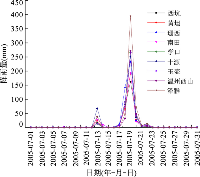
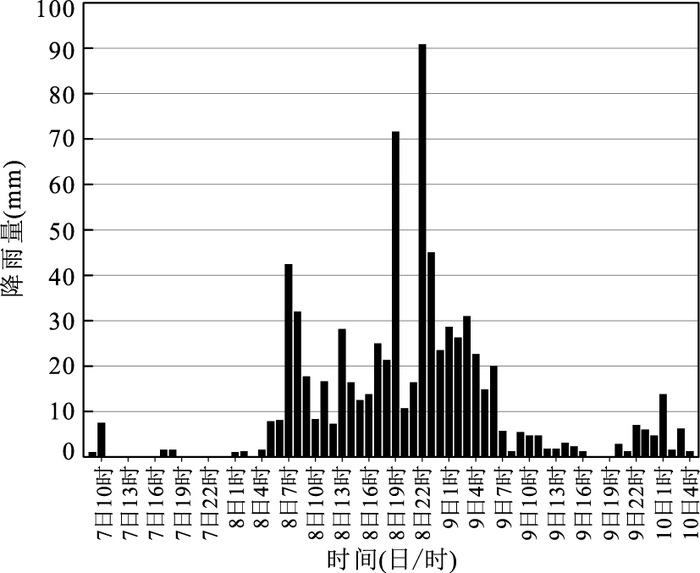
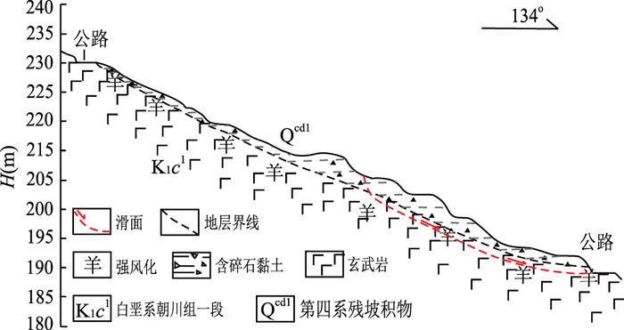
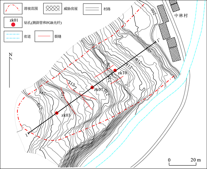
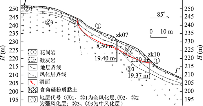
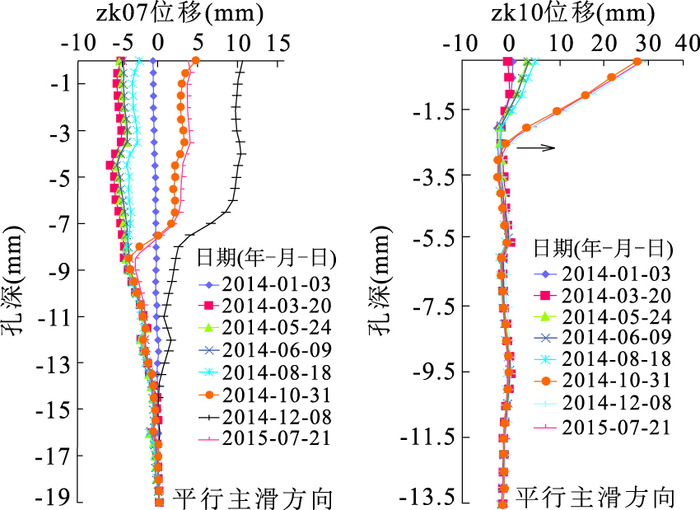
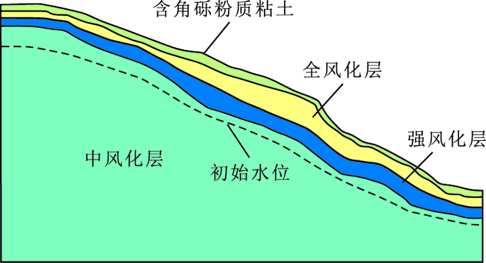
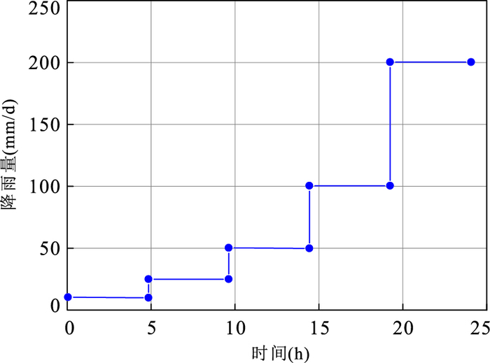
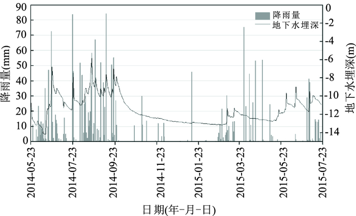
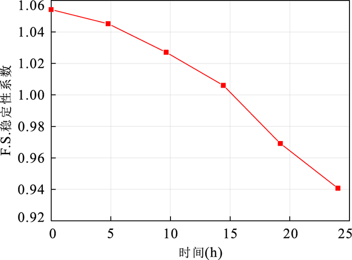
Typhoon rainstorm usually causes a large number of landslides leading to property and life losses. The research on the characteristics of groundwater seepage and genetic mechanism of landslides, therefore, is of great significance in early warning and forecasting of typhoon-induced-landslide. Taking Zhonglincun landslide located in Zhejiang province as an example, the paper used finite element method to simulate the transient seepage field and stability of the landslide under two conditions including rainfalls with constant intensity of 200 mm/d and gradually increased intensity. The results showed that the characteristics of groundwater seepage under both conditions were almost the same. The groundwater level responded rapidly and finally approached near the contact between strongly and moderately weathered strata, in addition, the ground water overflowed from the slope toe. The rising speed of groundwater level, however, was faster and the range was larger under the first condition. The factor of safety was closely related to the ground water level and rainfall intensity. Under the former condition, factor of safety decreased rapidly with increased water level, the falling speed slowed down after the water level became roughly stable. Failure mode of the Zhonglincun landslide can be summed up as creep-crack and slide-crack-creep, while rise of water table, decrease of matrix suction and increase of pore pressure in the slope were the main reasons leading to the failure of Zhonglincun landslide.
Typhoon rainstorm usually causes a large number of landslides leading to property and life losses. The research on the characteristics of groundwater seepage and genetic mechanism of landslides, therefore, is of great significance in early warning and forecasting of typhoon-induced-landslide. Taking Zhonglincun landslide located in Zhejiang province as an example, the paper used finite element method to simulate the transient seepage field and stability of the landslide under two conditions including rainfalls with constant intensity of 200 mm/d and gradually increased intensity. The results showed that the characteristics of groundwater seepage under both conditions were almost the same. The groundwater level responded rapidly and finally approached near the contact between strongly and moderately weathered strata, in addition, the ground water overflowed from the slope toe. The rising speed of groundwater level, however, was faster and the range was larger under the first condition. The factor of safety was closely related to the ground water level and rainfall intensity. Under the former condition, factor of safety decreased rapidly with increased water level, the falling speed slowed down after the water level became roughly stable. Failure mode of the Zhonglincun landslide can be summed up as creep-crack and slide-crack-creep, while rise of water table, decrease of matrix suction and increase of pore pressure in the slope were the main reasons leading to the failure of Zhonglincun landslide.