- 中文版:
- EI 100%收录
- 英文版
- SCI 100%收录


中国出版政府奖提名奖
中国百强科技报刊
湖北出版政府奖
中国高校百佳科技期刊
中国最美期刊
中国出版政府奖提名奖
中国百强科技报刊
湖北出版政府奖
中国高校百佳科技期刊
中国最美期刊
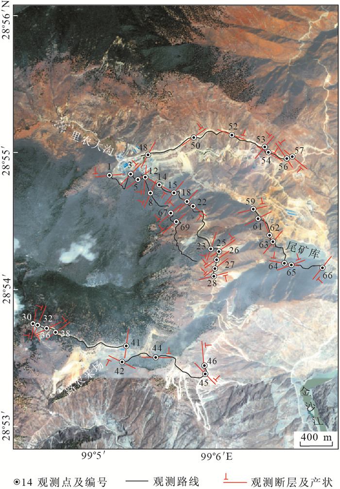
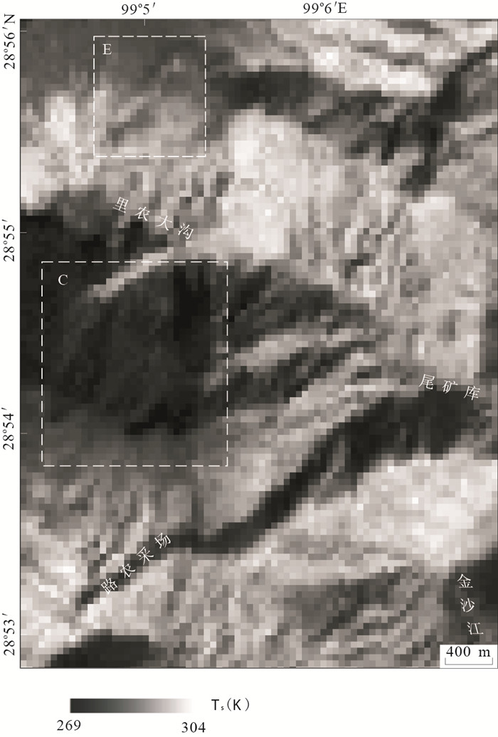
| Citation: | ZHOU Dan, ZHANG Zhen-fei, LONG Fei, LUO Cheng, 2013. Mapping Buried Faults Using the Temperature-Vegetation-Dryness Index with an Application in Yangla Copper Mining Area, Yunnan. Earth Science, 38(2): 423-430. doi: 10.3799/dqkx.2013.042

|

|
Bateson, L., Vellico, M., Beaubien, S.E., et al., 2008. The Application of Remote-Sensing Techniques to Monitor CO2-Storage Sites for Surface Leakage: Method Development and Testing at Latera (Italy) Where Naturally Produced CO2 Is Leaking to the Atmosphere. International Journal of Greenhouse Gas Control, 2(3): 388-400. doi: 10.1016/j.ijggc.2007.12.005
|
|
Carlson, T.N., Gillies, R.R., Perry, E.M., 1994. A Method to Make Use of Thermal Infrared Temperature and NDVI Measurements to Infer Surface Soil Water Content and Fractional Vegetation Cover. Romote Sensing Reviews, 9(1-2): 161-173. doi: 10.1080/02757259409532220
|
|
Cui, X.F., Xie, F.R., Zhang, H.Y., 2006. Recent Tectonic Stress Field Zoning in Sichuan-Yunnan Region and Its Dynamic Interest. Acta Seismologica Sinica, 19(5): 485-496. doi: 10.1007/s11589-006-0501-x
|
|
Genzano, N., Aliano, C., Pergola, N., et al., 2007. A Robust Satellite Technique for Monitoring Seismically Active Areas: The Case of Bhuj-Gujarat Earthquake. Tectonophysics, 431(1-4): 197-210. doi: 10.1016/j.tecto.2006.04.024
|
|
Goetz, S.J., 1997. Multi-Sensor Analysis of NDVI, Surface Temperature and Biophysical Variables at a Mixed Grassland Site. International Journal of Remote Sensing, 18(1): 71-94. doi: 10.1080/014311697219286
|
|
Goward, S.N., Xue, Y.K., Czajkowski, K.P., 2002. Evaluating Land Surface Moisture Conditions from the Remotely Sensed Temperature/Vegetation Index Measurements: An Exploration with the Simplified Simple Biosphere Model. Remote Sensing of Environment, 79(2-3): 225-242. doi: 10.1016/S0034-4257(01)00275-9
|
|
Ji, Q., He, L.L., Yu, M., et al., 2009. Study on Relationship between Land Use and Urban Heat Islands Based on Landsat ETM+ Remote Sensing Data. Journal of Fujian Normal University (Natural Science Edition), 25(6): 106-113(in Chinese with English abstract).
|
|
Liu, F.J., Wu, G.P., Guo, Y., et al., 2008. Extraction of Oil and Gas Haloes Based on ETM+ Data: A Case Study from Yakela, Xinjiang. Earth Science—Journal of China University of Geosciences, 33(1): 107-111(in Chinese with English abstract). doi: 10.3799/dqkx.2008.014
|
|
Moran, M.S., Clarke, T.R., Inoue, Y., et al., 1994. Estimating Crop Water Deficit Using the Relation between Surface-Air Temperature and Spectural Vegetation Index. Remote Sensing of Environment, 49(3): 246-263. doi: 10.1016/0034-4257(94)90020-5
|
|
Pulinets, S.A., Ouzounov, D., Karelin, A.V., et al., 2006. The Physical Nature of Thermal Anomalies Observed before Strong Earthquakes. Physics and Chemistry of the Earth, 31(4-9): 143-153. doi: 10.1016/j.pce.2006.02.042
|
|
Pulinets, S.A., Dunajecka, M.A., 2007. Specific Variations of Air Temperature and Relative Humidity around the Time of Michoacan Earthquake M8.1 Sept. 19, 1985 as a Possible Indicator of Interaction between Tectonic Plates. Tectonophysics, 431(1-4): 221-230. doi: 10.1016/j.tecto.2006.05.044
|
|
Qi, S.H., Wang, C.Y., Niu, Z., 2003. Evaluating Soil Moisture Status in China Using the Temperature/Vegetation Dryness Index(TVDI). Journal of Remote Sensing, 7(5): 420-427 (in Chinese with English abstract). http://www.oalib.com/paper/1468949
|
|
Qian, X.D., Qin, J.Z., Liu, L.F., 2011. Study on the Recent Tectonic Stress Field in the Yunnan Region. Earthquake Research in China, 25(4): 410-425. http://www.researchgate.net/publication/287560169_Study_on_recent_tectonic_stress_field_in_Yunnan_region
|
|
Qiang, Z.J., Kong, L.C., Guo, M.H., et al., 1997. An Experimental Study of Temperature Increasing Mechanism of Satellitic Thermoinfrared. Acta Seismologica Sinica, 19(2): 197-201 (in Chinese). doi: 10.1007/s11589-997-0093-0
|
|
Qin, Z.H., Li, W.J., Xu, B., 2004. The Estimation of Land Surface Emissivity for Landsat TM6. Remote Sensing for Land & Resources, 3: 29-42 (in Chinese with English abstract). http://www.researchgate.net/publication/292600766_The_estimation_of_land_surface_emissivity_for_landsat_TM6
|
|
Qu, C.Y., Ma, J., Shan, X.J., 2007. An Attempt to Observe Gas Releasing Phenomena of the Earth by Using Satellite Thermal Infrared Technique. Seismology and Geology, 26(3): 539-547 (in Chinese with English abstract). http://www.researchgate.net/publication/286917058_An_attempt_to_observe_gas_releasing_phenomena_of_the_earth_by_using_satellite_thermal_infrared_technique
|
|
Sandholt, I., Rasmussen, K., Andersen, J., 2002. A Simple Interpretation of the Surface Temperature/ Vegetation Index Space for Assessment of Surface Moisture Status. Remote Sensing of Environment, 79(2-3): 213-224. doi: 10.1016/S0034-4257(01)00274-7
|
|
Sobrino, J.A., Li, Z.L., Stoll, M.P., et al., 1994. Improvements in the Split-Window Technique for Landsurface Temperature Determination. IEEE Transactions on Geosciences and Remote Sensing, 32: 243-253. doi: 10.1109/36.295038
|
|
Surkov, V.V., Pokhotelov, O.A., Parrot, M., et al., 2006. On the Origin of Stable IR Anomalies Detected by Satellites above Seismo-Active Regions. Physics and Chemistry of the Earth, 31(4-9): 164-171. doi: 10.1016/j.pce.2006.02.020
|
|
Tronin, A.A., Masashi, H., Molchanov, O.A., 2002. Thermal IR Satellite Data Application for Earthquake Research in Japan and China. Journal of Geodynamics, 33(4-5): 519-534. doi: 10.1016/S0264-3707(02)00013-3
|
|
Van de Griend, A.A., Owe, M., 1993. On the Relationship between Thermal Emissivity and the Normalized Difference Vegetation Index for Natural Surfaces. International Journal of Remote Sensing, 14(6): 1119-1131. doi: 10.1080/01431169308904400
|
|
Van der Meer, F.D., Van der Werff, H.M.A., Van Ruitenbeek, F.J.A., et al., 2012. Multi- and Hyperspectral Geologic Remote Sensing: A Review. International Journal of Applied Earth Observation and Geoinformation, 14(1): 112-128. doi: 10.1016/j.jag.2011.08.002
|
|
Wu, M.C., Ding, J.L., Wang, G.F., 2012. Regional Soil Moisture Inversion Based on Surface Temperature and Vegetation Index Characteristic Spaces. Journal of Desert Research, 32(1): 148-154 (in Chinese with English abstract). http://en.cnki.com.cn/Article_en/CJFDTOTAL-ZGSS201201022.htm
|
|
Wu, W.Y., Zou, L.J., Shen, X.H., et al., 2012. Thermal Infrared Remote-Sensing Detection of Thermal Information Associated with Faults: A Case Study in Western Sichuan Basin, China. Journal of Asian Earth Sciences, 43(1): 110-117. doi: 10.1016/j.jseaes.2011.08.015
|
|
Zheng, G.Q., Lu, M., Zhang, T., et al., 2010. The Impact of Difference of Land Surface Emissivity on the Land Surface Temperature Retrieval of Jinan City. Journal of Shandong Jianzhu University, 25(5): 519-523(in Chinese with English abstract). http://en.cnki.com.cn/Article_en/CJFDTOTAL-SDJG201005011.htm
|
|
Zheng, L.Z., Qiang, Z.J., Lin, C.G., 1996. Practice and Research on Short Term Impending Earthquake Prediction by Interpreting Satellite Thermal Infrared Anomaly Image. Earth Science—Journal of China University of Geosciences, 21(6): 665-668 (in Chinese with English abstract).
|
|
季青, 贺伶俐, 余明, 等, 2009. 基于LandsatETM+数据的福州市土地利用/覆被与城市热岛的关系研究. 福建师范大学学报(自然科学版), 25(6): 106-113. https://www.cnki.com.cn/Article/CJFDTOTAL-FJSZ200906023.htm
|
|
刘福江, 吴国平, 郭艳, 等, 2008. 基于ETM+遥感影像油气晕反演: 以新疆雅克拉地区为例. 地球科学——中国地质大学学报, 33(1): 107-111. https://www.cnki.com.cn/Article/CJFDTOTAL-DQKX200801017.htm
|
|
齐述华, 王长耀, 牛铮, 2003. 利用温度植被旱情指数(TVDI)进行全国旱情监测研究. 遥感学报, 7(5): 420-427. https://www.cnki.com.cn/Article/CJFDTOTAL-YGXB200305012.htm
|
|
强祖基, 孔令昌, 郭满红, 等, 1997. 卫星热红外增温机制的实验研究. 地震学报, 19(2): 197-201. https://www.cnki.com.cn/Article/CJFDTOTAL-DZXB702.009.htm
|
|
覃志豪, 李文娟, 徐斌, 等, 2004. 陆地卫星TM6波段范围内地表比辐射率的估计. 国土资源遥感, 3: 29-42. https://www.cnki.com.cn/Article/CJFDTOTAL-GTYG200403007.htm
|
|
屈春燕, 马瑾, 单新建, 2004. 利用卫星热红外观测地球排气现象的一次尝试. 地震地质, 26(3): 539-547. doi: 10.3969/j.issn.0253-4967.2004.03.018
|
|
伍漫春, 丁建丽, 王高峰, 2012. 基于地表温度—植被指数特征空间的区域土壤水分反演. 中国沙漠, 32(1): 148-154. https://www.cnki.com.cn/Article/CJFDTOTAL-ZGSS201201022.htm
|
|
郑国强, 鲁敏, 张涛, 等, 2010. 地表比辐射率求算对济南市地表温度反演结果的影响. 山东建筑大学学报, 25(5): 519-523. doi: 10.3969/j.issn.1673-7644.2010.05.012
|
|
郑兰哲, 强祖基, 赁常恭, 1996. 卫星热红外影像在地震短临预报中的应用. 地球科学——中国地质大学学报, 21(6): 665-668. https://www.cnki.com.cn/Article/CJFDTOTAL-DQKX606.031.htm
|

Figures(6)

 DownLoad: