
- 中文版:
- EI 100%收录
- 英文版
- SCI 100%收录


中国出版政府奖提名奖
中国百强科技报刊
湖北出版政府奖
中国高校百佳科技期刊
中国最美期刊
中国出版政府奖提名奖
中国百强科技报刊
湖北出版政府奖
中国高校百佳科技期刊
中国最美期刊
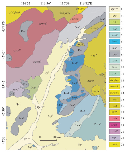
| Citation: | Zha Fengli, Ma Ming, Chen Shengbo, Liu Yanli, Li Yanqiu, Huang Shuang, 2015. Remote Sensing Lithologic Classification of Multispectral Data Based on the Vegetation Inhibition Method in the Vegetation Coverage Area. Earth Science, 40(8): 1403-1408. doi: 10.3799/dqkx.2015.125

|

|
Chen, S.B., Liu, Y.L., Yang, Q., et al., 2012. Lithologic Classification from Hyperspectral Data in Dense Vegetation Cover Area. Journal of Jilin University(Earth Science Edition), 42(6): 1959-1965(in Chinese with English abstract). http://en.cnki.com.cn/Article_en/CJFDTOTAL-CCDZ201206044.htm
|
|
Clark, R.N., Swayze, G.A., 1995. Mapping Minerals, Amorphous Materials, Environmental Materials, Vegetation, Water, Ice and Snow, and Other Materials: The USGS Tricorder Algorithm. Summaries of the Fifth Annual JPL Airborne Earth Science Workshop, 95(1): 39-40.
|
|
James, K.C., David, W.B., Lawrence, C.R., et al., 1989. Airborne Imaging Spectrometer Data of the Ruby Mountains, Montana: Mineral Discrimination Using Relative Absorption Band-Depth Images. Remote Sensing of Environment, 29(2): 121-134. doi: 10.1016/0034-4257(89)90021-7
|
|
Roger, N.C., Trude, V.V.K., Matthew Klejwa, G.A., et al., 1990. High Spectral Resolution Reflectance Spectroscopy of Minerals. Journal of Geophysical Research, 95(B8): 12653-12680. doi: 10.1029/JB095Ib08p12653
|
|
Wang, Y.D., Shen, X.L., Xie, J., 2006. A Review of Remote Sensing Image Classification Method. Remote Sensing Information, (5): 67-71 (in Chinese with English abstract).
|
|
陈圣波, 刘彦丽, 杨倩, 等, 2012. 植被覆盖区卫星高光谱遥感岩性分类. 吉林大学学报(地球科学版), 42(6): 1959-1965. https://www.cnki.com.cn/Article/CJFDTOTAL-CCDZ201206044.htm
|
|
王一达, 沈熙玲, 谢炯, 2006. 遥感图像分类方法综述. 遥感信息, (5): 67-71. doi: 10.3969/j.issn.1000-3177.2006.05.021
|
Figures(4) / Tables(3)

 DownLoad:


