- 中文版:
- EI 100%收录
- 英文版
- SCI 100%收录


中国出版政府奖提名奖
中国百强科技报刊
湖北出版政府奖
中国高校百佳科技期刊
中国最美期刊
中国出版政府奖提名奖
中国百强科技报刊
湖北出版政府奖
中国高校百佳科技期刊
中国最美期刊
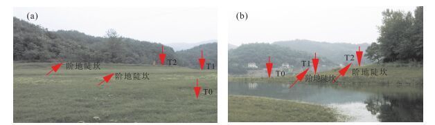
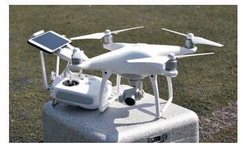
| Citation: | Li Hui, Yu Zhongdi, Cai Xiaobin, Hu Zunyu, 2017. River Terrace Extraction Based on Unmanned Aerial Vehicle Remote Sensing. Earth Science, 42(5): 734-742. doi: 10.3799/dqkx.2017.061

|

|
Del Val, M., Iriarte, E., Arriolabengoa, M., et al., 2015.An Automated Method to Extract Fluvial Terraces from LIDAR Based High Resolution Digital Elevation Models:The Oiartzun Valley, a Case Study in the Cantabrian Margin.Quaternary International, 364:35-43.doi: 10.1016/j.quaint.2014.10.030
|
|
Demoulin, A., Bovy, B., Rixhon, G., et al., 2007.An Automated Method to Extract Fluvial Terraces from Digital Elevation Models:The Vesdre Valley, a Case Study in Eastern Belgium.Geomorphology, 91(1-2):51-64.doi: 10.1016/j.geomorph.2007.01.020
|
|
Diaz-Varela, R.A., Zarco-Tejada, P.J., Angileri, V., et al., 2014.Automatic Identification of Agricultural Terraces through Object-Oriented Analysis of very High Resolution DSMs and Multispectral Imagery Obtained from an Unmanned Aerial Vehicle.Journal of Environmental Management, 134(4):117-126.doi: 10.1016/j.jenvman.2014.01.006
|
|
Erlanger, E.D., Granger, D.E., Gibbon, R.J., 2012.Rock Uplift Rates in South Africa from Isochron Burial Dating of Fluvial and Marine Terraces.Geology, 40(11):1019-1022.doi: 10.1130/g33172.1
|
|
Gonalves, J.A., Henriques, R., 2015.UAV Photogrammetry for Topographic Monitoring of Coastal Areas.ISPRS Journal of Photogrammetry and Remote Sensing, 104:101-111.doi: 10.1016/j.isprsjprs.2015.02.009
|
|
Gong, H.L., Ran, Y.K., 2015.Digital Terrain Analysis of Anning River Terraces Based on SPOT Image.North China Earthquake Sciences, 33(3):31-36(in Chinese with English abstract).
|
|
Gong, H.L., Ran, Y.K., Chen, L.C., 2008.The Method of Terrace Analysis Based on Dem—A Case Study in Zimakua of Anninghe Fault.Seismology and Geology, 30(1):339-348 (in Chinese with English abstract). https://www.researchgate.net/publication/286960856_The_method_of_terrace_analysis_based_on_DEM_-_A_case_study_in_Zimakua_of_Anninghe_Fault
|
|
Han, F., Zhang, K.X., Wei, Y., et al., 2010.Sedimentary Sequences and Paleoclimate of Late Pleistocene in Xunhua Basin, Qinghai Province.Earth Science, 35(5):849-856(in Chinese with English abstract).
|
|
Hu, X.F., Pan, B.T., Gao, H.S., et al., 2013.Development of Holocene Fluvial Terraces in the Eastern Qilianshan Mountain and Its Relationship with Climatic Changes.Quaternary Sciences, 33(4):723-736(in Chinese with English abstract). http://en.cnki.com.cn/Article_en/CJFDTOTAL-DSJJ201304010.htm
|
|
Jin, W., Ge, H.L., Du, H.Q., et al., 2009.A Review on Unmanned Aerial Vehicle Remote Sensing and Its Application.Remote Sensing Information, (1):88-92(in Chinese with English abstract).
|
|
Lewin, J., Gibbard, P.L., 2010.Quaternary River Terraces in England:Forms, Sediments and Processes.Geomorphology, 120(3-4):293-311.doi: 10.1016/j.geomorph.2010.04.002
|
|
Li, B., Liu, R.Y., Liu, S.H., et al., 2012.Monitoring Vegetation Coverage Variation of Winter Wheat by Low-Altitude UAV Remote Sensing System.Transactions of the Chinese Society of Agricultural Engineering, 28(13):160-165(in Chinese with English abstract).
|
|
Lowe, D.G., 2004.Distinctive Image Features from Scale-Invariant Key Points.International Journal of Computer Vision, 60(2):91-110.doi: 10.1023/b:visi.0000029664.99615.94
|
|
Pang, J.L., Huang, C.C., Zhou, Y.L., et al., 2014.Formation of the First River Terraces of Hanjiang River and Its Response to the East Asian Monsoon Change.Geological Review, 60(5):1076-1084(in Chinese with English abstract).
|
|
Passaro, S., Ferranti, L., de Alteriis, G.D., 2011.The Use of High-Resolution Elevation Histograms for Mapping Submerged Terraces:Tests from the Eastern Tyrrhenian Sea and the Eastern Atlantic Ocean.Quaternary International, 232(1-2):238-249.doi: 10.1016/j.quaint.2010.04.030
|
|
Schildgen, T.F., Cosentino, D., Bookhagen, B., et al., 2012.Multi-Phased Uplift of the Southern Margin of the Central Anatolian Plateau, Turkey:A Record of Tectonic and Upper Mantle Processes.Earth and Planetary Science Letters, 317-318:85-95.doi: 10.1016/j.epsl.2011.12.003
|
|
D'Oleireoltmanns, S., Marzolff, I., Peter, K.D., et al., 2012.Unmanned Aerial Vehicle(UAV) for Monitoring Soil Erosion in Morocco.Remote Sensing, 4(11):3390-3416.
|
|
Smith, M.W., Carrivick, J.L., Quincey, D.J., 2015.Structure from Motion Photogrammetry in Physical Geography.Progress in Physical Geography, 40(2):247-275.doi: 10.1177/0309133315615805
|
|
Song, Z.Q., Zhang, J.L., Li, J.J., 2014.A Clustering Approach for Incorporation Spatial Dependence into the Automatic Fluvial Terrace Extraction from Digital Elevation Model:A Case Study from the Zhangla Basin along the Upstream of the Minjiang River.Seismology and Geology, 36(4):1029-1042 (in Chinese with English abstract).
|
|
Tonkin, T.N., Midgley, N.G., Graham, D.J., et al., 2014.The Potential of Small Unmanned Aircraft Systems and Structure-from-Motion for Topographic Surveys:A Test of Emerging Integrated Approaches at Cwm Idwal, North Wales.Geomorphology, 226(1-2):35-43.doi: 10.1016/j.geomorph.2014.07.021
|
|
Turner, D., Lucieer, A., Watson, C., 2012.An Automated Technique for Generating Georectified Mosaics from Ultra-High Resolution Unmanned Aerial Vehicle (UAV) Imagery, Based on Structure from Motion (SfM) Point Clouds.Remote Sensing, 4(12):1392-1410.doi: 10.3390/rs4051392
|
|
Wang, P.T., Shao, Y.X., Zhang, H.P., et al., 2016.The Application of sUAV Photogrammetry in Active Tectonics:Shanmagou Site of Haiyuan Fault, for Example.Quaternary Sciences, 36(2):433-442 (in Chinese with English abstract).
|
|
Wei, Z.Y., Ramon, A., He, H.L., et al., 2015.Accuracy Analysis of Terrain Point Cloud Acquired by "Structure from Motion" Using Aerial Photos.Seismology and Geology, 37(2):636-648(in Chinese with English abstract).
|
|
Xiang, F., Zhu, L.D., Wang, C.S., et al., 2005.Terrace Age Correlation and Its Significance in Research of Yangtze Three Gorges, China.Journal of Chengdu University of Technology(Science & Technology Edition), 32(2):162-166(in Chinese with English abstract).
|
|
Zhang, Z.L., Wu, S.R., Tang, H.M., et al., 2015.Control Effect of Evolution Process of the Yellow River Terrace in Lanzhou on Landslide Activity.Earth Science, 40(9):1585-1597(in Chinese with English abstract).
|
|
宫会玲, 冉勇康, 2015.基于SPOT影像的安宁河阶地数字地形分析.华北地震科学, 33(3):31-36. http://www.cnki.com.cn/Article/CJFDTOTAL-HDKD201503008.htm
|
|
宫会玲, 冉勇康, 陈立春, 2008.基于DEM的阶地分析方法——以安宁河断裂紫马跨地区为例.地震地质, 30(1):339-348. http://www.cnki.com.cn/Article/CJFDTOTAL-DZDZ200801026.htm
|
|
韩芳, 张克信, 韦一, 等, 2010.青海循化盆地晚更新世沉积序列与古气候.地球科学, 35(5):849-856. http://www.earth-science.net/WebPage/Article.aspx?id=2029
|
|
胡小飞, 潘保田, 高红山, 等, 2013.祁连山东段全新世河流阶地发育及其与气候变化的关系研究.第四纪研究, 33(4):723-736. http://www.cnki.com.cn/Article/CJFDTOTAL-DSJJ201304010.htm
|
|
金伟, 葛宏立, 杜华强, 等, 2009.无人机遥感发展与应用概况.遥感信息, (1):88-92. http://www.cnki.com.cn/Article/CJFDTOTAL-YGXX200901020.htm
|
|
李冰, 刘镕源, 刘素红, 等, 2012.基于低空无人机遥感的冬小麦覆盖度变化监测.农业工程学报, 28(13):160-165. http://www.cnki.com.cn/Article/CJFDTOTAL-NYGU201213027.htm
|
|
庞奖励, 黄春长, 周亚利, 等, 2014.汉江上游Ⅰ级河流阶地形成及对东亚季风变化的响应.地质论评, 60(5):1076-1084. http://www.cnki.com.cn/Article/CJFDTOTAL-DZLP201405013.htm
|
|
宋卓沁, 张军龙, 李建军, 2014.基于模糊聚类和空间自相关性的河流阶地自动提取方法——以岷江上游漳腊盆地为例.地震地质, 36(4):1029-1042. http://www.cnki.com.cn/Article/CJFDTOTAL-DZDZ201404008.htm
|
|
王朋涛, 邵延秀, 张会平, 等, 2016.sUAV摄影技术在活动构造研究中的应用——以海原断裂骟马沟为例.第四纪研究, 36(2):433-442. http://cdmd.cnki.com.cn/Article/CDMD-85402-1015543026.htm
|
|
魏占玉, Ramon, A., 何宏林, 等, 2015.基于SfM方法的高密度点云数据生成及精度分析.地震地质, 37(2):636-648. http://www.cnki.com.cn/Article/CJFDTOTAL-DZDZ201502024.htm
|
|
向芳, 朱利东, 王成善, 等, 2005.长江三峡阶地的年代对比法及其意义.成都理工大学学报(自然科学版), 32(2):162-166. http://www.cnki.com.cn/Article/CJFDTOTAL-CDLG20050200A.htm
|
|
张泽林, 吴树仁, 唐辉明, 等, 2015.兰州黄河阶地演变过程对滑坡活动的控制效应.地球科学, 40(9):1585-1597. http://www.earth-science.net/WebPage/Article.aspx?id=3162
|
Figures(8) / Tables(3)

 DownLoad: