- 中文版:
- EI 100%收录
- 英文版
- SCI 100%收录


中国出版政府奖提名奖
中国百强科技报刊
湖北出版政府奖
中国高校百佳科技期刊
中国最美期刊
中国出版政府奖提名奖
中国百强科技报刊
湖北出版政府奖
中国高校百佳科技期刊
中国最美期刊
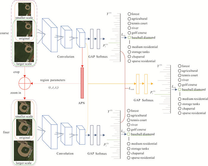
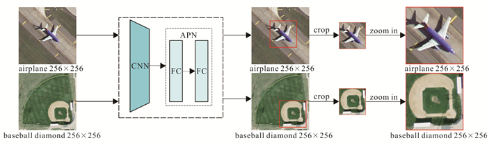
| Citation: | Ma Xinyue, Wang Liming, Qi Kunlun, Zheng Guizhou, 2021. Remote Sensing Image Scene Classification Method Based on Multi-Scale Cyclic Attention Network. Earth Science, 46(10): 3740-3752. doi: 10.3799/dqkx.2020.365

|

|
Bahdanau, D., Cho, K., Bengio, Y., 2014. Neural Machine Translation by Jointly Learning to Align and Translate. Computer Science, arXiv: 1409.0473. https://arxiv.org/abs/1409.0473
|
|
Castelluccio, M., Poggi, G., Sansone, C., et al., 2015. Land Use Classification in Remote Sensing Images by Convolutional Neural Networks. Acta Ecologica Sinica, 28(2): 627-635. http://pdfs.semanticscholar.org/4191/fe93bfd883740a881e6a60e54b371c2f241d.pdf
|
|
Chen, Q.H., Liu, Z.M., Liu, X.G., et al., 2010. Element-Oriented Land-Use Classification of Mining Area by High Spatial Resolution Remote Sensing Image. Earth Science, 35(3): 453-458(in Chinese with English abstract). http://ieeexplore.ieee.org/xpls/icp.jsp?arnumber=5631116
|
|
Chen, S.Z., Tian, Y.L., 2014. Pyramid of Spatial Relatons for Scene-Level Land Use Classification. IEEE Transactions on Geoscience and Remote Sensing, 53(4): 1947-1957. https://doi.org/10.1109/TGRS.2014.2351395
|
|
Cheng, G., Han, J., Lu, X., 2017. Remote Sensing Image Scene Classification: Benchmark and State of the Art. Proceedings of the IEEE, 105(10): 1865-1883. https://doi.org/10.1109/JPROC.2017.2675998
|
|
Cheng, G., Ma, C. C., Zhou, P. C., et al., 2016. Scene Classification of High Resolution Remote Sensing Images Using Convolutional Neural Networks. In Proceedings 2016 IEEE International Geoscience and Remote Sensing Symposium (IGARSS), Beijing, 767-770. https://doi.org/10.1109/IGARSS.2016.7729193
|
|
Cheng, G.X., Niu, R.Q., Zhang, K.X., et al., 2018. Opencast Mining Area Recognition in High-Resolution Remote Sensing Images Using Convolutional Neural Networks. Earth Science, 43(Suppl. 2): 256-262(in Chinese with English abstract). http://en.cnki.com.cn/Article_en/CJFDTotal-DQKX2018S2021.htm
|
|
Fu, J.L., Zheng, H.L., Mei, T., 2017. Look Closer to See Better: Recurrent Attention Convolutional Neural Network for Fine-Grained Image Recognition. In Proceedings of the IEEE Conference on Computer Vision and Pattern Recognition (CVPR), Honolulu Hawaii, 4476-4484. https://doi.org/10.1109/CVPR.2017.476
|
|
Gómez-Chova, L., Tuia, D., Moser, G., et al., 2015. Multimodal Classification of Remote Sensing Images: A Review and Future Directions. Proceedings of the IEEE, 103(9): 1560-1584. https://doi.org/10.1109/JPROC.2015.2449668
|
|
Han, X.B., Zhong, Y.F., Cao, L.Q., et al., 2017. Pre-Trained AlexNet Architecture with Pyramid Pooling and Supervision for High Spatial Resolution Remote Sensing Image Scene Classification. Remote Sensing, 9(8): 848. https://doi.org/10.3390/rs9080848
|
|
He, K.M., Zhang, X.Y., Ren, S Q., et al., 2016. Deep Residual Learning for Image Recognition. In Proceedings of the IEEE Conference on Computer Vision and Pattern Recognition (CVPR), Las Vegas Nevada, 770-778. https://doi.org/10.1109/CVPR.2016.90
|
|
He, N.J., Fang, L.Y., Li, S.T., et al., 2018. Remote Sensing Scene Classification Using Multilayer Stacked Covariance Pooling. IEEE Transactions on Geoscience and Remote Sensing, 56(12): 6899-6910. https://doi.org/10.1109/TGRS.2018.2845668
|
|
Jia, Y.Q., Shelhamer, E., Donahue, J., et al., 2014. Caffe: Convolutional Architecture for Fast Feature Embedding. In Proceedings of the 22nd ACM International Conference on Multimedia, Orlando Florida USA, 675-678. https://doi.org/10.1145/2647868.2654889
|
|
Ketkar, N., 2017. Introduction to PyTorch. Deep Learning with Python. Apress, Berkeley, CA, 195-208. https://doi.org/10.1007/978-1-4842-2766-4_12
|
|
Li, G.D., Zhang, C.J., Wang, M.K., et al., 2019. Transfer Learning Using Convolutional Neural Network for Scene Classification within High Resolution Remote Sensing Image. Science of Surveying and Mapping, 44(4): 116-123, 174(in Chinese with English abstract). http://en.cnki.com.cn/Article_en/CJFDTotal-CHKD201904021.htm
|
|
Li, W.K., Zhang, W., Qin, J.H., et al., 2020. "Expansion-Fusion" Extraction of Surface Gully Area Based on DEM and High-Resolution Remote Sensing Images. Earth Science, 45(6): 1948-1955(in Chinese with English abstract).
|
|
Lienou, M., Maitre, H., Datcu, M., 2009. Semantic Annotation of Satellite Images Using Latent Dirichlet Allocation. IEEE Geoscience and Remote Sensing Letters, 7(1): 28-32. https://doi.org/10.1109/LGRS.2009.2023536
|
|
Luo, W., Li, H. L., Liu, G. H., 2011. Automatic Annotation of Multispectral Satellite Images Using Author-Topic Model. IEEE Geoscience and Remote Sensing Letters, 9(4): 634-638. https://doi.org/10.1109/LGRS.2011.2177064
|
|
Nogueira, K., Penatti, O. A. B., dos Santos, J.A., 2017. Towards Better Exploiting Convolutional Neural Networks for Remote Sensing Scene Classification. Pattern Recognition, 61: 539-556. https://doi.org/10.1016/j.patcog.2016.07.001
|
|
Oliva, A., Torralba, A., 2001. Modeling the Shape of the Scene: A Holistic Representation of the Spatial Envelope. International Journal of Computer Vision, 42(3): 145-175. https://doi.org/10.1023/A:1011139631724
|
|
Pan, S. J., Yang, Q., 2009. A Survey on Transfer Learning. IEEE Transactions on Knowledge and Data Engineering, 22(10): 1345-1359. https://doi.org/10.1109/TKDE.2009.191
|
|
Simonyan, K., Zisserman, A., 2014. Very Deep Convolutional Networks for Large-Scale Image Recognition. CoRR. Computer Science, arXiv: 1409.1556.
|
|
Szegedy, C., Liu, W., Jia, Y.Q., et al., 2015. Going Deeper with Convolutions. In Proceedings of the IEEE Conference on Computer Vision and Pattern Recognition (CVPR). Boston, MA, IEEE, 1-9. https://doi.org/10.1109/CVPR.2015.7298594
|
|
Xia, G. S., Hu, J. W., Hu, F., et al., 2017. AID: A Benchmark Data Set for Performance Evaluation of Aerial Scene Classification. IEEE Transactions on Geoscience and Remote Sensing, 55(7): 3965-3981. https://doi.org/10.1109/TGRS.2017.2685945
|
|
Yang, Y., Newsam, S., 2010. Bag-of-Visual-Words and Spatial Extensions for Land-Use Classification. In Proceedings of the ACM International Symposium on Advances in Geographic Information Systems, San Jose California, 270-279. https://doi.org/10.1145/1869790.1869829
|
|
Yang, Y., Newsam, S., 2013. Geographic Image Retrieval Using Local Invariant Features. IEEE Transactions on Geoscience and Remote Sensing, 51(2): 818-832. https://doi.org/10.1109/TGRS.2012.2205158
|
|
Yu, D.H., Zhang, B.M., Zhao, C., et al., 2020. Scene Classification of Remote Sensing Image Using Ensemble Convolutional Neural Network. Journal of Remote Sensing, 24(6): 717-727(in Chinese with English abstract).
|
|
Yu, S.C., Yu, D.Q., Wang, L.C., et al., 2019. Remote Sensing Study of Dongting Lake Beach Changes before and after Operation of Three Gorges Reservoir. Earth Science, 44(12): 4275-4283(in Chinese with English abstract). http://en.cnki.com.cn/Article_en/CJFDTotal-DQKX201912037.htm
|
|
Yuan, Y., Fang, J., Lu, X.Q., et al., 2019. Remote Sensing Image Scene Classification Using Rearranged Local Features. IEEE Transactions on Geoscience and Remote Sensing, 57(3): 1779-1792. https://doi.org/10.1109/TGRS.2018.2869101
|
|
Zhang, D., Li, N., Ye, Q.L., 2019. Positional Context Aggregation Network for Remote Sensing Scene Classification. IEEE Geoscience and Remote Sensing Letters, 17(6): 943-947. https://doi.org/10.1109/LGRS.2019.2937811
|
|
Zhao, Z.C., Li, J.Q., Luo, Z., et al., 2020. Remote Sensing Image Scene Classification Based on an Enhanced Attention Module. IEEE Geoscience and Remote Sensing Letters, (99): 1-5. https://doi.org/10.1109/LGRS.2020.3011405
|
|
陈启浩, 刘志敏, 刘修国, 等, 2010. 面向基元的高空间分辨率矿区遥感影像土地利用分类. 地球科学, 35(3): 453-458. doi: 10.3799/dqkx.2010.055
|
|
程国轩, 牛瑞卿, 张凯翔, 等, 2018. 基于卷积神经网络的高分遥感影像露天采矿场识别. 地球科学, 43(增刊2): 256-262. doi: 10.3799/dqkx.2018.987
|
|
李冠东, 张春菊, 王铭恺, 等, 2019. 卷积神经网络迁移的高分影像场景分类学习. 测绘科学, 444): 116-123, 174. https://www.cnki.com.cn/Article/CJFDTOTAL-CHKD201904021.htm
|
|
李文凯, 张唯, 秦家豪, 等, 2020. 基于DEM和高分辨率遥感影像的"膨胀-融合"式地表沟壑提取. 地球科学, 45(6): 1948-1955. doi: 10.3799/dqkx.2020.004
|
|
余东行, 张保明, 赵传, 等, 2020. 联合卷积神经网络与集成学习的遥感影像场景分类. 遥感学报, 24(6): 717-727. https://www.cnki.com.cn/Article/CJFDTOTAL-YGXB202006006.htm
|
|
余姝辰, 余德清, 王伦澈, 等, 2019. 三峡水库运行前后洞庭湖洲滩面积变化遥感认识. 地球科学, 44(12): 4275-4283. doi: 10.3799/dqkx.2019.182
|

Figures(11) / Tables(6)

 DownLoad: