- 中文版:
- EI 100%收录
- 英文版
- SCI 100%收录


中国出版政府奖提名奖
中国百强科技报刊
湖北出版政府奖
中国高校百佳科技期刊
中国最美期刊
中国出版政府奖提名奖
中国百强科技报刊
湖北出版政府奖
中国高校百佳科技期刊
中国最美期刊
| Citation: | Lin Nan, Xu Yaochen, Gao Bowen, Weng Xuhua, Chen Ninghua, 2021. Semi-Automatic Extraction of Triangular Facet Attitude Based on Edge Extraction Algorithm. Earth Science, 46(10): 3753-3763. doi: 10.3799/dqkx.2021.060

|

|
Berger, Z., Williams, T.H.L., Anderson, D.W., 1992. Geological Stereo Mapping of Geologic Structures with SPOT Satellite Data. Bull. Am. Assoc. Petrol. Geol., 76(1): 101-120. http://aapgbull.geoscienceworld.org/content/76/1/101
|
|
Bilotti, F., Shaw, J.H., Brennan, P.A., 2000. Quantitative Structural Analysis with Stereoscopic Remote Sensing Imagery. AAPG Bulletin, 84(6): 727-740. https://doi.org/10.1306/a96733d8-1738-11d7-8645000102c1865d
|
|
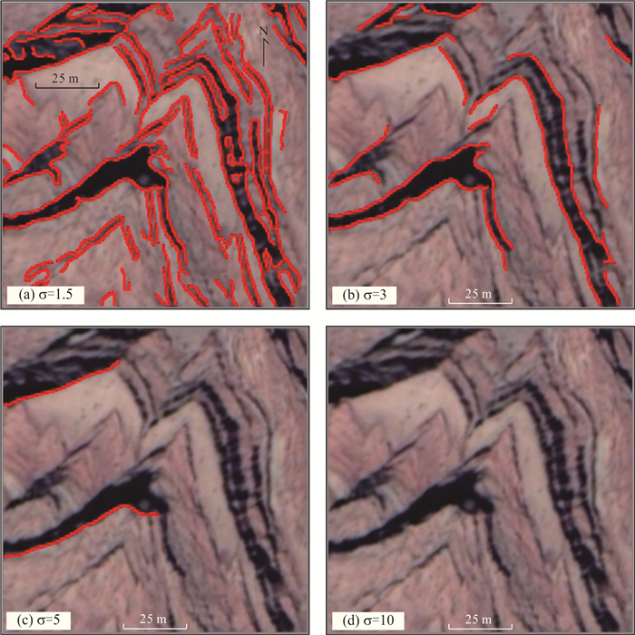
Canny, J., 1986. A Computational Approach to Edge Detection. IEEE Transactions on Pattern Analysis and Machine Intelligence, 8(6): 679-698. http://www.researchgate.net/publication/301840781_A_computational_approach_to_edge_detection_IEEE_Transactions_on_Pattern_Analysis_and_Machine_Intelligence
|
|
Chen, N.H., Ni, N.N., Kapp, P., et al., 2015. Structural Analysis of the Hero Range in the Qaidam Basin, Northwestern China, Using Integrated UAV, Terrestrial LiDAR, Landsat 8, and 3-D Seismic Data. IEEE Journal of Selected Topics in Applied Earth Observations and Remote Sensing, 8(9): 4581-4591. https://doi.org/10.1109/JSTARS.2015.2440171
|
|
Chen, N.H., Wang, X., Yang, S.F., 2007. Quantitative Extraction of Shallow Stratum Information Based on CORONA Imagery. Journal of Zhejiang University (Engineering Science), 41(4): 662-667(in Chinese with English abstract). http://www.cnki.com.cn/Article/CJFDTotal-ZDZC200704026.htm
|
|
Cracknell, M. J., Roach, M., Green, D., et al., 2013. Estimating Bedding Orientation from High-Resolution Digital Elevation Models. IEEE Transactions on Geoscience and Remote Sensing, 51(5): 2949-2959. https://doi.org/10.1109/TGRS.2012.2217502
|
|
Ding, H., Yao, A.Q., 2012. DEM Generation and Analysis Using IKONOS Stereo Pairs. Science of Surveying and Mapping, 37(1): 179-181(in Chinese with English abstract). http://www.en.cnki.com.cn/Article_en/CJFDTotal-CHKD201201062.htm
|
|
Foroutan, M., Zimbelman, J.R., 2017. Semi-Automatic Mapping of Linear-Trending Bedforms Using 'Self-Organizing Maps' Algorithm. Geomorphology, 293: 156-166. https://doi.org/10.1016/j.geomorph.2017.05.016
|
|
Guo, Q.Q., Li, S.L., Liu, Z.M., 2016. Platform of Online Interpretation and Attitude Measurement for Faults Using High Resolution Remote Sensing Image. Remote Sensing for Land & Resources, 28(1): 190-196(in Chinese with English abstract). http://www.cnki.com.cn/Article/CJFDTotal-GTYG201601029.htm
|
|
He, D.F., Yuan, H., Li, D., et al., 2011. Chronology, Geochemistry and Tectonic Setting of Granites at the Core of Tugerming Anticline, Tarim Basin: Indications of Paleozoic Extensional and Compressional Cycle at the Northern Margin of Tarim Continental Block. Acta Petrologica Sinica, 27(1): 133-146(in Chinese with English abstract). http://www.oalib.com/paper/1475929
|
|
Jin, M.S., Wu, J.L., Chen, L., et al., 2015. Application of High-Resolution Remote Sensing Data Combined with 3D Approach Geological Investigation in the Eastern Kunlun Mountain Area. Mineral Exploration, 6(5): 609-614(in Chinese with English abstract). http://en.cnki.com.cn/Article_en/CJFDTOTAL-YSJS201505016.htm
|
|
Liu, H.G., Ran, Y.K., Li, A., et al., 2011. Attitude Extraction of Shallow Stratum Based on P5 Stereo Images and GeoEye-1 Image. Seismology and Geology, 33(4): 951-962(in Chinese with English abstract). http://proceedings.spiedigitallibrary.org/proceeding.aspx?articleid=2476369
|
|
Liu, C.J., Ding, L.Q., Sun, D.Y., 2011. Automatic Fuzzy Clustering Analysis and Geometric Information Acquisition of Rock Mass Discontinuities Based on Laser Point Cloud Data. Chinese Journal of Rock Mechanics and Engineering, 30(2): 358-364(in Chinese with English abstract). http://www.researchgate.net/publication/289214117_Automatic_fuzzy_clustering_analysis_and_geometric_information_acquisition_of_rock_mass_discontinuities_based_on_laser_point_cloud_data
|
|
Liu, X., Lü, X.B., Wu, C.M., et al., 2020. Topographic Correction Method for High Spatial Resolution Remote Sensing Data in Mountainous Area. Earth Science, 45(2): 645-662(in Chinese with English abstract).
|
|
Philipson, W.R., 1960. Manual of Photographic Interpretation. American Society for Photogrammetry, Washington D.C. .
|
|
Sang, X.J., 2018. Application of UAV and Deep Learning in Geological Survey: A Case Study of Xingcheng City in Liaoning and Beishan Area in Gansu Province(Dissertation). Jilin University, Changchun(in Chinese with English abstract).
|
|
Song, B.W., Zhang, K.X., Xu, Y.D., et al., 2020. Paleogene Tectonic-Stratigraphic Realms and Sedimentary Sequence in China. Earth Science, 45(12): 4352-4369(in Chinese with English abstract). http://www.researchgate.net/publication/352838064_Neogene_tectonic-stratigraphic_realms_and_sedimentary_sequence_in_China
|
|
Vasuki, Y., Holden, E.J., Kovesi, P., et al., 2013. A Geological Structure Mapping Tool Using Photogrammetric Data. ASEG Extended Abstracts, 1-4. https://doi.org/10.1071/ASEG2013ab144
|
|
Wang, L, . 2016. DEM Extracted by Stereo Images of High Resolution Satellite and Accuracy Analysis in Plateau(Dissertation). Chengdu University of Technology, Chengdu(in Chinese with English abstract).
|
|
Wang, S.Y., Ai, M., Wu, C.Y., et al., 2018. Application of DEM Generation Technology from High Resolution Satellite Image in Quantitative Active Tectonics Study: A Case Study of Fault Scarps in the Southern Margin of Kumishi Basin. Seismology and Geology, 40(5): 999-1017(in Chinese with English abstract). http://www.zhangqiaokeyan.com/academic-journal-cn_seismology-geology_thesis/0201270242403.html
|
|
Yang, H.B., Yang, X.P., Huang, X.N., et al., 2016. Data Comparative Analysis between SFM Data and DGPS Data: A Case Study from Fault Scarp in the East Bank of Hongshuiba River, Northern Margin of the Qilian Shan. Seismology and Geology, 38(4): 1030-1046(in Chinese with English abstract). http://www.researchgate.net/publication/313597914_Data_comparative_analysis_between_SfM_data_and_DGPS_data_A_case_study_from_fault_scarp_in_the_east_bank_of_Hongshuiba_River_northern_margin_of_the_Qilian_Shan
|
|
Zhu, L.P., 1994. Geology Remote Sensing. Geological Publishing House, Beijing(in Chinese).
|
|
陈宁华, 汪新, 杨树锋, 2007. 基于CORONA影像的浅层地层信息定量提取. 浙江大学学报(工学版), 41(4): 662-667. doi: 10.3785/j.issn.1008-973X.2007.04.027
|
|
丁辉, 姚安强, 2012. 利用IKONOS立体像对提取DEM精度的实验. 测绘科学, 37(1): 179-181. https://www.cnki.com.cn/Article/CJFDTOTAL-CHKD201201062.htm
|
|
郭啟倩, 李盛乐, 刘珠妹, 2016. 断层高分辨率遥感在线解译及产状测量平台. 国土资源遥感, 28(1): 190-196. https://www.cnki.com.cn/Article/CJFDTOTAL-GTYG201601029.htm
|
|
何登发, 袁航, 李涤, 等, 2011. 吐格尔明背斜核部花岗岩的年代学、地球化学与构造环境及其对塔里木地块北缘古生代伸展聚敛旋回的揭示. 岩石学报, 27(1): 133-146. https://www.cnki.com.cn/Article/CJFDTOTAL-YSXB201101009.htm
|
|
金谋顺, 吴君丽, 陈玲, 等, 2015. 高分遥感数据结合三维技术在东昆仑地区地质调查中的应用. 矿产勘查, 6(5): 609-614. doi: 10.3969/j.issn.1674-7801.2015.05.016
|
|
刘昌军, 丁留谦, 孙东亚, 2011. 基于激光点云数据的岩体结构面全自动模糊群聚分析及几何信息获取. 岩石力学与工程学报, 30(2): 358-364. https://www.cnki.com.cn/Article/CJFDTOTAL-YSLX201102021.htm
|
|
刘华国, 冉勇康, 李安, 等, 2011. 基于P5像对与GeoEye-1影像的近地表地层产状的提取. 地震地质, 33(4): 951-962. doi: 10.3969/j.issn.0253-4967.2011.04.018
|
|
柳潇, 吕新彪, 吴春明, 等, 2020. 面向高空间分辨率遥感影像的山区地形校正方法. 地球科学, 45(2): 645-662. doi: 10.3799/dqkx.2019.012
|
|
桑学佳, 2018. 无人机及深度学习在地质调查中的应用(博士学位论文). 长春: 吉林大学.
|
|
宋博文, 张克信, 徐亚东, 等, 2020. 中国古近纪构造-地层区划及地层格架. 地球科学, 45(12): 4352-4369. doi: 10.3799/dqkx.2020.122
|
|
王蕾, 2016. 高原地区高分辨率卫星立体像对提取DEM及精度分析(硕士学位论文). 成都: 成都理工大学.
|
|
汪思妤, 艾明, 吴传勇, 等, 2018. 高分辨率卫星影像提取DEM技术在活动构造定量研究中的应用: 以库米什盆地南缘断裂陡坎为例. 地震地质, 40(5): 999-1017. https://www.cnki.com.cn/Article/CJFDTOTAL-DZDZ201805005.htm
|
|
杨海波, 杨晓平, 黄雄南, 等, 2016. 移动摄影测量数据与差分GPS数据的对比分析: 以祁连山北麓洪水坝河东岸断层陡坎为例. 地震地质, 38(4): 1030-1046. https://www.cnki.com.cn/Article/CJFDTOTAL-DZDZ201604018.htm
|
|
朱亮璞, 1994. 遥感地质学. 北京: 地质出版社.
|
Figures(10) / Tables(1)

 DownLoad: