- 中文版:
- EI 100%收录
- 英文版
- SCI 100%收录


中国出版政府奖提名奖
中国百强科技报刊
湖北出版政府奖
中国高校百佳科技期刊
中国最美期刊
中国出版政府奖提名奖
中国百强科技报刊
湖北出版政府奖
中国高校百佳科技期刊
中国最美期刊
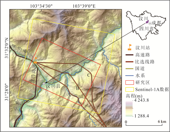
| Citation: | Liu Peiyuan, Chang Ming, Wu Binbin, Luo Chaopeng, Zhou Chao, 2022. Route Selection of Landslide Prone Area in Wenchuan Section of Chengdu-Wenchuan Expressway Based on SBAS-InSAR. Earth Science, 47(6): 2048-2057. doi: 10.3799/dqkx.2022.069

|

|
Berardino, P., Fornaro, G., Lanari, R., et al., 2002. A New Algorithm for Surface Deformation Monitoring Based on Small Baseline Differential SAR Interferograms. IEEE Transactions on Geoscience and Remote Sensing, 40(11): 2375-2383. https://doi.org/10.1109/tgrs.2002.803792
|
|
Bürgmann, R., Rosen, P., Fielding, E., 2000. Synthetic Aperture Radar Interferometry to Measure Earth's Surface Topography and Its Deformation. Annual Review of Earth and Planetary Sciences, 28(1): 169-209. https://doi.org/10.1146/annurev.earth.28.1.169
|
|
Chen, F. L., Lin, H., Li, Z., et al., 2012. Interaction between Permafrost and Infrastructure along the Qinghai-Tibet Railway Detected via Jointly Analysis of C- and L-Band Small Baseline SAR Interferometry. Remote Sensing of Environment, 123: 532-540. https://doi.org/10.1016/j.rse.2012.04.020
|
|
Chen, Q., Liu, G. X., Hu, Z. Q., et al., 2012. Mapping Ground 3-D Displacement with GPS and PS-InSAR Networking in the Pingtung Area, Southwestern Taiwan, China. Chinese Journal of Geophysics, 55(10): 3248-3258(in Chinese with English abstract).
|
|
Cheng, S., Yi, J. Q., 2007. Geological Hazards and Their Preventions in Wenchuan County, Sichuan Province. Journal of Geological Hazards and Environment Preservation, 18(4): 1-6(in Chinese with English abstract).
|
|
Dong, X. J., Wang, D., Feng, T., 2019. Research on the Application of Unmanned Aerial Vehicle Digital Photogrammetry in Landslide Disaster Investigation. Journal of Geological Hazards and Environment Preservation, 30(3): 77-84(in Chinese with English abstract).
|
|
Feng, W. K., Dun, J. W., Yi, X. Y., et al., 2020. Deformation Analysis of Woda Village Old Landslide in Jinsha River Basin Using SBAS-INSAR Technology. Journal of Engineering Geology, 28(2): 384-393(in Chinese with English abstract).
|
|
Ferretti, A., Prati, C., Rocca, F. L., 1999. Permanent Scatterers in SAR Interferometry. Remote Sensing. Proc SPIE 3869, SAR Image Analysis, Modeling, and Techniques II. Florence, Italy, 139-145. https://doi.org/10.1117/12.373150
|
|
Galarreta, J. F., Kerle, N., Gerke, M., 2015. UAV-Based Urban Structural Damage Assessment Using Object-Based Image Analysis and Semantic Reasoning. Natural Hazards and Earth System Sciences, 15(6): 1087-1101. https://doi.org/10.5194/nhess-15-1087-2015
|
|
Guo, J. M., Hu, J. Y., Li, B., et al., 2017. Land Subsidence in Tianjin for 2015 to 2016 Revealed by the Analysis of Sentinel-1A with SBAS-InSAR. Journal of Applied Remote Sensing, 11: 026024. https://doi.org/10.1117/1.jrs.11.026024
|
|
Huang, R. Q., 2007. Large-Scale Landslides and Their Sliding Mechanisms in China since the 20th Century. Chinese Journal of Rock Mechanics and Engineering, 26(3): 433-454(in Chinese with English abstract).
|
|
Huo, D. P., Zhang, B., Peng, J. H., et al., 2015. Review and Prospective of Landslide Deformation Monitoring. Geotechnical Investigation & Surveying, 43(8): 62-67(in Chinese with English abstract).
|
|
Li, D., Deng, K. Z., Gao, X. X., et al., 2018. Monitoring and Analysis of Surface Subsidence in Mining Area Based on SBAS-InSAR. Geomatics and Information Science of Wuhan University, 43(10): 1531-1537(in Chinese with English abstract).
|
|
Lin, H., Ma, P. F., Wang, W. X., 2017. Urban Infrastructure Health Monitoring with Spaceborne Multi-Temporal Synthetic Aperture Radar Interferometry. Acta Geodaetica et Cartographica Sinica, 46(10): 1421-1433(in Chinese with English abstract).
|
|
Liu, G. W., 2016. Application of Multi-Scale 3D Remote Sensing Technology for Geological Investigation in Railway. Journal of Railway Engineering Society, 33(8): 40-43, 99(in Chinese with English abstract).
|
|
Liu, X. Y., Yang, Z. H., Guo, C. B., et al., 2017. Study of Slow-Moving Landslide Characteristics Based on the SBAS-InSAR in the Xianshuihe Fault Zone. Geoscience, 31(5): 965-977(in Chinese with English abstract).
|
|
Lu, H. Y., Li, W. L., Xu, Q., et al., 2019. Early Detection of Landslides in the Upstream and Downstream Areas of the Baige Landslide, the Jinsha River Based on Optical Remote Sensing and InSAR Technologies. Geomatics and Information Science of Wuhan University, 44(9): 1342-1354(in Chinese with English abstract).
|
|
Lü, X. K., Chen, J. J., 2015. Three-Dimensional Geological Environment Modeling Method for Digital Railway Alignment. Journal of the China Railway Society, 37(8): 91-97(in Chinese with English abstract).
|
|
Ma, P. F., Wang, W. X., Zhang, B. W., et al., 2019. Remotely Sensing Large- and Small-Scale Ground Subsidence: A Case Study of the Guangdong-Hong Kong-Macao Greater Bay Area of China. Remote Sensing of Environment, 232: 111282. https://doi.org/10.1016/j.rse.2019.111282
|
|
Meng, H., Zhang, R. L., Shi, J. S., et al., 2021. Geological Environment Safety Evaluation. Earth Science, 46(10): 3764-3776(in Chinese with English abstract).
|
|
Shi, X. G., Xu, J. H., Jiang, H. J., et al., 2019. Slope Stability State Monitoring and Updating of the Outang Landslide, Three Gorges Area with Time Series InSAR Analysis. Earth Science, 44(12): 4284-4292(in Chinese with English abstract).
|
|
Shi, Y., Li, W. X., Tang, Y. M., et al., 2019. Time Series InSAR Measurement for Earth Environmental Monitoring and Resource Management: A Case Study of Jiaocheng-Qingxu Area. Geomatics and Information Science of Wuhan University, 44(11): 1613-1621(in Chinese with English abstract).
|
|
Tao, Y. L., Zhang, M., 2019. Research on Mine Surface GPS Monitoring Based on Beidou System. Mineral Exploration, 10(12): 2990-2994(in Chinese with English abstract).
|
|
Wang, G. J., Xie, M. W., Qiu, C., et al., 2010. Application of D-INSAR Technique to Landslide Monitoring. Rock and Soil Mechanics, 31(4): 1337-1344(in Chinese with English abstract).
|
|
Wang, R. Y., 2015. Research on High Resolution Land Subsidence Monitoring Technology Based on SBAS InSAR(Dissertation). China University of Geosciences, Beijing(in Chinese with English abstract).
|
|
Wang, X. M., Yin, J., Luo, M. H., et al. 2021. Active High-Locality Landslides in Mao County: Early Identification and Deformational Rules. Journal of Earth Science. https://doi.org/10.1007/s12583-021-1505-0
|
|
Xu, Q., Dong, X. J., Li, W. L., 2019. Integrated Space-Air-Ground Early Detection, Monitoring and Warning System for Potential Catastrophic Geohazards. Geomatics and Information Science of Wuhan University, 44(7): 957-966(in Chinese with English abstract).
|
|
Yin, K. L., Han, Z. S., Li, Z. Z., 2000. Progress of Landslide Researches in the World. Hydrogeology and Engineering Geology, 27(5): 1-4(in Chinese with English abstract).
|
|
Yin, Y. P., Pan, G. T., Liu, Y. P., 2009. Introduction to Wenchuan Earthquake Geology and Landslide Disaster. Geological Publishing House, Beijing(in Chinese).
|
|
Yu, M. Y., Yu, C. Q., Qu, C., et al., 2021. Deep Structural Characteristics of Pengguan Complex in Longmenshan Fault Zone Derived from Seismic Reflective Profile. Earth Science, 46(5): 1737-1748(in Chinese with English abstract).
|
|
Zhu, J. J., Li, Z. W., Hu, J., 2017. Research Progress and Methods of InSAR for Deformation Monitoring. Acta Geodaetica et Cartographica Sinica. 46(10): 1717-1733(in Chinese with English abstract).
|
|
陈强, 刘国祥, 胡植庆, 等, 2012. GPS与PS-InSAR联网监测的台湾屏东地区三维地表形变场. 地球物理学报, 55(10): 3248-3258. doi: 10.6038/j.issn.0001-5733.2012.10.007
|
|
程思, 易加强, 2007. 四川省汶川县地质灾害的成因及防治对策. 地质灾害与环境保护, 18(4): 1-6. doi: 10.3969/j.issn.1006-4362.2007.04.001
|
|
董秀军, 王栋, 冯涛, 2019. 无人机数字摄影测量技术在滑坡灾害调查中的应用研究. 地质灾害与环境保护, 30(3): 77-84. doi: 10.3969/j.issn.1006-4362.2019.03.013
|
|
冯文凯, 顿佳伟, 易小宇, 等, 2020. 基于SBAS-InSAR技术的金沙江流域沃达村巨型老滑坡形变分析. 工程地质学报, 28(2): 384-393. https://www.cnki.com.cn/Article/CJFDTOTAL-GCDZ202002019.htm
|
|
黄润秋, 2007.20世纪以来中国的大型滑坡及其发生机制. 岩石力学与工程学报, 26(3): 433-454. doi: 10.3321/j.issn:1000-6915.2007.03.001
|
|
霍东平, 张彬, 彭军还, 等, 2015. 滑坡变形监测技术研究现状与展望. 工程勘察, 43(8): 62-67. https://www.cnki.com.cn/Article/CJFDTOTAL-GCKC201508013.htm
|
|
李达, 邓喀中, 高晓雄, 等, 2018. 基于SBAS-InSAR的矿区地表沉降监测与分析. 武汉大学学报(信息科学版), 43(10): 1531-1537. https://www.cnki.com.cn/Article/CJFDTOTAL-WHCH201810014.htm
|
|
林珲, 马培峰, 王伟玺, 2017. 监测城市基础设施健康的星载MT-InSAR方法介绍. 测绘学报, 46(10): 1421-1433. doi: 10.11947/j.AGCS.2017.20170339
|
|
刘桂卫, 2016. 多尺度三维遥感技术在某铁路地质勘察中应用. 铁道工程学报, 33(8): 40-43, 99. doi: 10.3969/j.issn.1006-2106.2016.08.009
|
|
刘筱怡, 杨志华, 郭长宝, 等, 2017. 基于SBAS-InSAR的鲜水河断裂带蠕滑型滑坡特征研究. 现代地质, 31(5): 965-977. doi: 10.3969/j.issn.1000-8527.2017.05.008
|
|
陆会燕, 李为乐, 许强, 等, 2019. 光学遥感与InSAR结合的金沙江白格滑坡上下游滑坡隐患早期识别. 武汉大学学报(信息科学版), 44(9): 1342-1354. https://www.cnki.com.cn/Article/CJFDTOTAL-WHCH201909011.htm
|
|
吕希奎, 陈进杰, 2015. 铁路数字化选线三维地质环境建模方法. 铁道学报, 37(8): 91-97. doi: 10.3969/j.issn.1001-8360.2015.08.014
|
|
孟晖, 张若琳, 石菊松, 等, 2021. 地质环境安全评价. 地球科学, 46(10): 3764-3776. doi: 10.3799/dqkx.2019.031
|
|
史绪国, 徐金虎, 蒋厚军, 等, 2019. 时序InSAR技术三峡库区藕塘滑坡稳定性监测与状态更新. 地球科学, 44(12): 4284-4292. doi: 10.3799/dqkx.2019.180
|
|
师芸, 李伟轩, 唐亚明, 等, 2019. 时序InSAR技术在地球环境监测及其资源管理中的应用: 以交城-清徐地区为例. 武汉大学学报(信息科学版), 44(11): 1613-1621. https://www.cnki.com.cn/Article/CJFDTOTAL-WHCH201911005.htm
|
|
王桂杰, 谢谟文, 邱骋, 等, 2010. D-INSAR技术在大范围滑坡监测中的应用. 岩土力学, 31(4): 1337-1344. doi: 10.3969/j.issn.1000-7598.2010.04.057
|
|
王如意, 2015. 基于SBAS-InSAR的高分辨率地面沉降监测技术研究(博士学位论文). 北京: 中国地质大学.
|
|
许强, 董秀军, 李为乐. 2019. 基于天-空-地一体化的重大地质灾害隐患早期识别与监测预警. 武汉大学学报(信息科学版), 44(7): 957-966. https://www.cnki.com.cn/Article/CJFDTOTAL-WHCH201907002.htm
|
|
殷坤龙, 韩再生, 李志中, 2000. 国际滑坡研究的新进展. 水文地质工程地质, 27(5): 1-4. doi: 10.3969/j.issn.1000-3665.2000.05.001
|
|
殷跃平, 潘桂棠, 刘宇平, 2009. 汶川地震地质与滑坡灾害概论. 北京: 地质出版社.
|
|
于明羽, 于常青, 瞿辰, 等, 2021. 从反射地震剖面认识龙门山断裂带彭灌杂岩深部结构. 地球科学, 46(5): 1737-1748. doi: 10.3799/dqkx.2020.020
|
|
张明, 2019. 基于北斗系统的矿山地表GPS监测研究. 矿产勘查, 10(12): 2990-2994. doi: 10.3969/j.issn.1674-7801.2019.12.015
|
|
朱建军, 李志伟, 胡俊, 2017. InSAR变形监测方法与研究进展. 测绘学报, 46(10): 1717-1733. doi: 10.11947/j.AGCS.2017.20170350
|
Figures(9) / Tables(2)

 DownLoad: