- 中文版:
- EI 100%收录
- 英文版
- SCI 100%收录


中国出版政府奖提名奖
中国百强科技报刊
湖北出版政府奖
中国高校百佳科技期刊
中国最美期刊
中国出版政府奖提名奖
中国百强科技报刊
湖北出版政府奖
中国高校百佳科技期刊
中国最美期刊
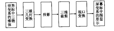
| Citation: | XI Da-ping, JIANG Wen-ping, 2002. Research and Application of Three-Dimensional Visibility Based on Digital Map. Earth Science, 27(3): 278-284.

|

| [1] |
江文萍, 杜清运. 《中国深圳》光盘地图中三维模拟飞行的研制[J]. 地图, 2000, (4): 13-15. https://www.cnki.com.cn/Article/CJFDTOTAL-DITU200004007.htm
JIANG W P, DUQ Y. Research& development of 3D simulant flight in Shenzhen of China CD-ROM map[J]. Cartography, 2000, (4): 13-15. https://www.cnki.com.cn/Article/CJFDTOTAL-DITU200004007.htm
|
| [2] |
邬伦, 刘瑜, 马修军, 等. 地理信息系统[M]. 第一版. 北京: 科学出版社, 2001.
WU L, LIU Y, MA X J, et al. Geographic information system[M]. lst Edtion. Beijing: Science Press, 2001.
|
| [3] |
Moore R R, Johnson S E. Three-dimensional reconstruction
and modeling of complexly folded surfaces using mathematics
[J]. Computers and Geosciences, 2001, 27 (4): 401-418. doi: 10.1016/S0098-3004(00)00079-0
|
| [4] |
Marschallinger R. Three-dimensional reconstruction and visualization of geological materials with IDL— examples and source
code[J]. Computers and Geosciences, 2001, 27 (4): 419-426. doi: 10.1016/S0098-3004(00)00126-6
|
| [5] |
江文萍, 杜清运. 数字地图三维可视化的若干研究与应用[A]. 第三届两岸测绘发展研讨会论文集[C]. 香港: [s. n. ], 2000.80-89.
JIANG W P, DU Q Y. Researches and applications of 3D visibility of digital map[A]. Proceedings of the 3rd Across-theStrait geomatics conference[C]. Hongkong: [s. n. ], 2000.
|
| [6] |
周成虎, 李军. 地球空间元数据研究[J]. 地球科学———中国地质大学学报, 2000, 25 (6): 579-585. https://www.cnki.com.cn/Article/CJFDTOTAL-DQKX200006006.htm
ZHOU C H, LI J. Research into geo-spatial metadata[J].
Earth Science—Journal of China University of Geosciences, 2000, 25 (6): 579-585. https://www.cnki.com.cn/Article/CJFDTOTAL-DQKX200006006.htm
|
| [7] |
戴福初, 李军, 张晓晖. 城市建设用地与地质环境协调性评价的GIS方法及其应用[J]. 地球科学———中国地质大学学报, 2000, 25 (2): 209-214. https://www.cnki.com.cn/Article/CJFDTOTAL-DQKX200002019.htm
DAI F C, LI J, ZHANG X H. GIS method and its applications
to evaluation of coordination between urban land use and geoenvironmental potential[J]. Earth Science—Journal of China
University of Geosciences, 2000, 25 (2): 209-214. https://www.cnki.com.cn/Article/CJFDTOTAL-DQKX200002019.htm
|
Figures(14)

 DownLoad: