
- 中文版:
- EI 100%收录
- 英文版
- SCI 100%收录


中国出版政府奖提名奖
中国百强科技报刊
湖北出版政府奖
中国高校百佳科技期刊
中国最美期刊
中国出版政府奖提名奖
中国百强科技报刊
湖北出版政府奖
中国高校百佳科技期刊
中国最美期刊
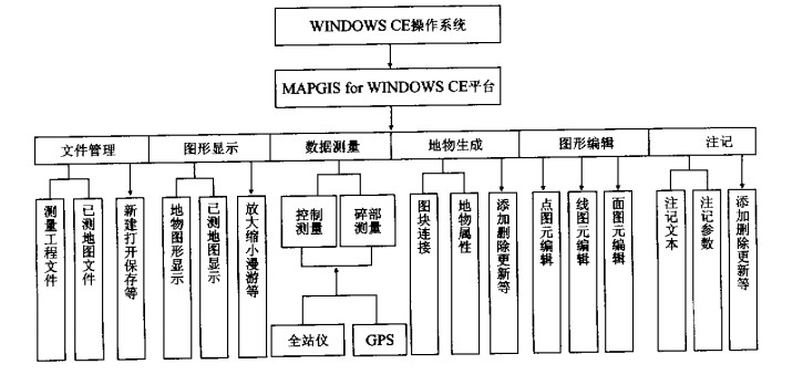
| Citation: | FAN Wen-you, XIE Zhong, XU Shi-wu, 2002. Design and Realization of Digital Surveying and Mapping of Pocket PC Based on MAPGIS. Earth Science, 27(3): 289-292.

|

| [1] |
樊文有, 谢忠. GIS空间数据的误差校正[J]. 地球科学———中国地质大学学报, 1998, 23(4): 344-347. https://www.cnki.com.cn/Article/CJFDTOTAL-DQKX804.006.htm
FAN W Y, XIE Z. Error rectification of geographic information system map data[J]. Earth Science—Journal of China University of Geosciences, 1998, 23(4): 344-347. https://www.cnki.com.cn/Article/CJFDTOTAL-DQKX804.006.htm
|
| [2] |
杨德麟. 大比例尺数字测图的原理方法与应用[M]. 北京: 清华大学出版社, 1998.
YANG D L. Theory, method and application of a large-scale digital surveying and mapping system[M]. Beijing: Tsinghua University Press, 1998.
|
| [3] |
陈刘成, 郝金明, 吕志伟. 基于Windws CE的GPS观测数据质量检测系统[J]. 测绘通报, 2001, 11: 19-20. https://www.cnki.com.cn/Article/CJFDTOTAL-CHTB200111010.htm
CHEN LC, HAO J M, Lü Z W. The GPS raw data quality detection system based on Windows CE[J]. Bulletin of Surveying and Mapping, 2001, 11: 19-20. https://www.cnki.com.cn/Article/CJFDTOTAL-CHTB200111010.htm
|
| [4] |
李德仁, 关泽群. 空间信息系统的集成与实现[M]. 武汉: 武汉测绘科技大学出版社, 2000.
LI D R, GUAN Z Q. The integration and realization of space information system[M]. Wuhan: Wuhan Technical University of Surveying and Mapping Press, 2000.
|
| [5] |
李超岭, 张克信. 基于GIS技术的区域性多源地学空间信息集成若干问题探讨[J]. 地球科学———中国地质大学学报, 2001, 26(6): 545-550. https://www.cnki.com.cn/Article/CJFDTOTAL-DQKX200105021.htm
LI C L, ZHANG K X. study on regional multi-source geological Spatial information system based on techniques of GIS[J]. Earth Science—Journal of China University of Geosciences, 2001, 26(6): 545-550. https://www.cnki.com.cn/Article/CJFDTOTAL-DQKX200105021.htm
|
| [6] |
周成虎, 李军. 地球空间元数据研究[J]. 地球科学———中国地质大学学报, 2000, 25(6): 579-585. https://www.cnki.com.cn/Article/CJFDTOTAL-DQKX200006006.htm
ZHOUC H, LI J. Disquisition on metadata of geospace[J]. Earth Science—Journal of China University of Geosciences, 2000, 25(6): 579-585. https://www.cnki.com.cn/Article/CJFDTOTAL-DQKX200006006.htm
|
| [7] |
Goggin TA. WINDOWS CE高级开发指南[M]. 龙滔, 张平, 周晓权, 等译. 北京: 电子工业出版社, 2000.
Goggin TA. Aguide to the advanced development aboutWINDOWS CE[M]. Beijing: The Electrical Industry Press, 2000.
|
| [8] |
张夏林, 汪新庆, 吴冲龙. 计算机辅助地质填图属性数据采集子系统的动态数据模型[J]. 地球科学———中国地质大学学报, 2001, 26(2): 201-204. https://www.cnki.com.cn/Article/CJFDTOTAL-DQKX200102021.htm
ZHANG X L, WANG XQ, WUC L. The dynamic data model of attribute data processing subsystem in computer aided geological map filling[J]. Earth Science—Journal of China University of Geosciences, 2001, 26(2): 201-204. https://www.cnki.com.cn/Article/CJFDTOTAL-DQKX200102021.htm
|
| [9] |
石伟伟, 钟耳顺, 王康宏, 等. 以GIS为核心的数字化成图系统的设计与实现[A]. 2001中国GIS年会论文集[C]. 成都: [s. n. ], 2001.
SHI W W, ZHONG E S, WANG K H, et al. The development of digital mapping system for GIS[A]. The collection of articles in 2001 annual meeting of Chinese GIS[C]. Chengdu: [s. n. ], 2001.
|
| [10] |
GB/T7929-1995, 1∶ 500 1∶ 1 000 1∶ 2 000地形图图式[S]. 北京: 中国标准出版社, 1995.
GB/T7929-1995, Specifications for cartographic symbols 1∶ 500 1∶1 000 1∶2 000 topographic maps[S]. Beijing: China Standard Press, 1995.
|
Figures(1)

 DownLoad: