


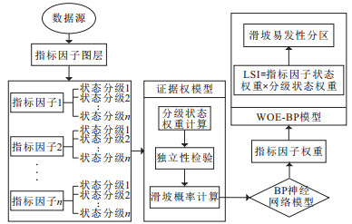
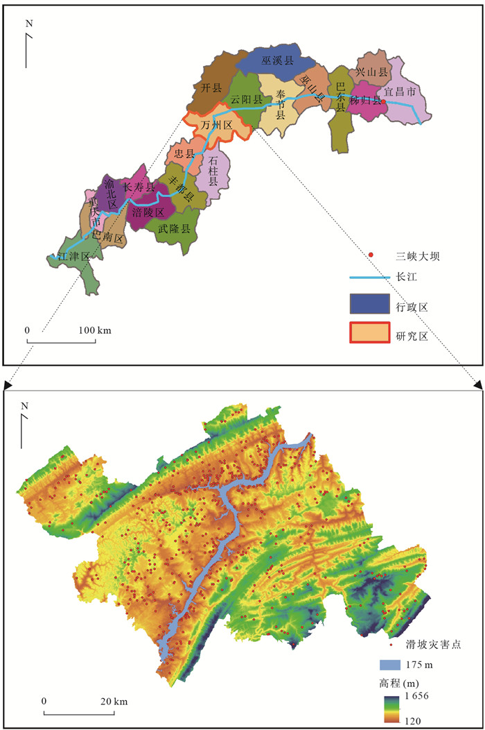
Evaluation of Landslide Susceptibility Based on GIS and WOE-BP Model
-
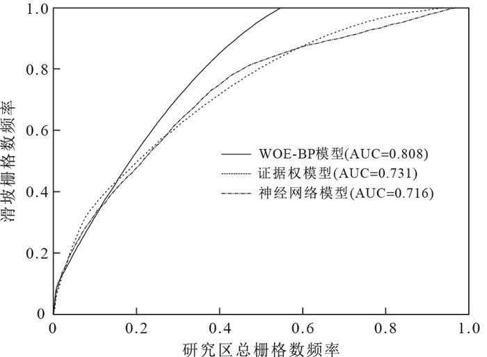
摘要: 区域滑坡易发性研究对地质灾害风险管理具有重要意义.以往研究中,将多元统计模型与机器学习方法相结合用于滑坡易发性评价的研究较少.以三峡库区万州区为例,首先选取9种指标因子(坡度、坡向、剖面曲率、地表纹理、地层岩性、斜坡结构、地质构造、水系分布及土地利用类型)作为滑坡易发性评价指标.基于证据权模型(weights of evidence,WOE)计算得到的对比度和滑坡面积比与分级面积比的相对大小,对各指标因子进行状态分级;再利用粒子群法优化的BP神经网络模型(PSO-BP)得到各指标因子权重.综合两种模型确定的状态分级权重和指标因子权重(WOE-BP)计算滑坡易发性指数(landslide susceptibility index,LSI),基于GIS平台得到全区滑坡易发性分区图.结果表明:水系、地层岩性和地质构造是影响万州区滑坡发育的主要指标因子;WOE-BP模型的预测精度为80.8%,优于WOE模型的73.1%和BP神经网络模型的71.6%,可为定量计算指标因子权重和优化滑坡易发性评价提供有效途径.Abstract: Susceptibility assessment of region landslides plays an important role in geological hazard risk management. In previous studies, few of them applied the combination of multivariate statistic model and machine learning method to assess landslide susceptibility. Taking Wanzhou District of Three Gorges reservoir as an example, nine index factors including slope angle, slope direction, curvature, terrain surface texture, stratum lithology, slope structure, geological structure, water distribution and land use, were selected as the evaluation indexes of landslide susceptibility. The state of each index was graded based on the contrast values calculated by weights of evidence (WOE) model, landslide area ratio and grading area ratio firstly. Then the BP neural network model optimized by particle swarm optimization (PSO-BP) was applied to obtain the weight of each index. The landslide susceptibility index (LSI) was calculated by the combining weight of states and weight of indexes determined by these two models (WOE-BP) and landslide susceptibility mapping was obtained based on the GIS platform. The results indicate that water distribution, stratum lithology and geological structure are the main index factors influencing the development of landslides in Wanzhou District. The accuracy of the WOE-BP model reaches 80.8%, better than 73.1% of WOE model and 71.6% of BP neural network model. The proposed model provides an effective approach for calculating the weight of index quantificationally and optimizing the landslide susceptibility evaluation.
-
Key words:
- landslide /
- index factor /
- weight of evidence model /
- BP neural network /
- GIS /
- geological hazard
-
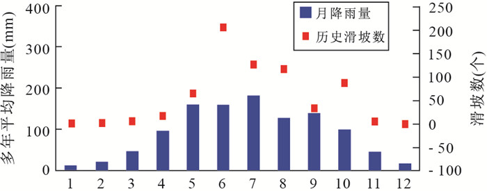
图 4 万州区历史滑坡数及降雨时间分布特征
Fig. 4. The time distribution characteristic of history landslide number and rainfall in Wanzhou District
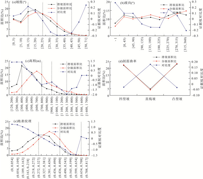
图 5 地形地貌类因子状态分级统计图
Fig. 5. Statistical results of state classification of topography index
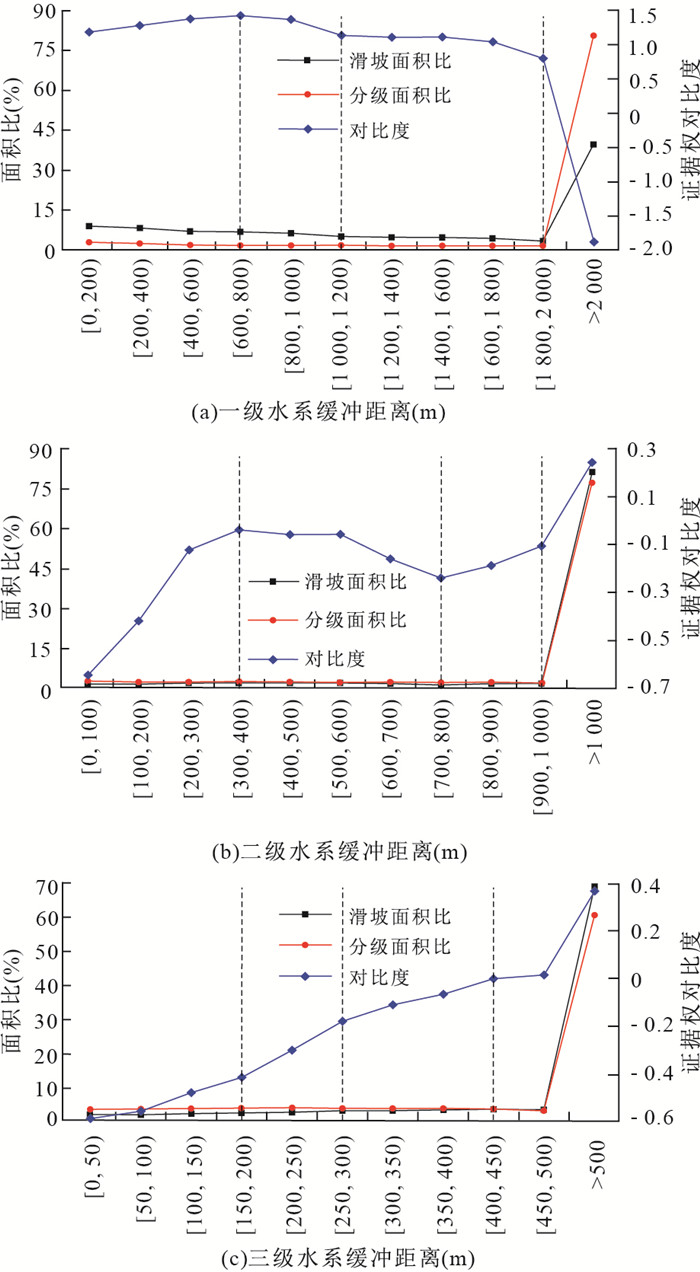
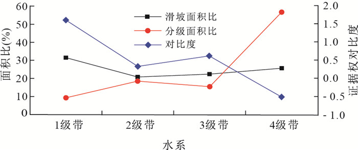
图 6 不同级别水系状态分级
Fig. 6. Statistical results of state classification of different levels water system
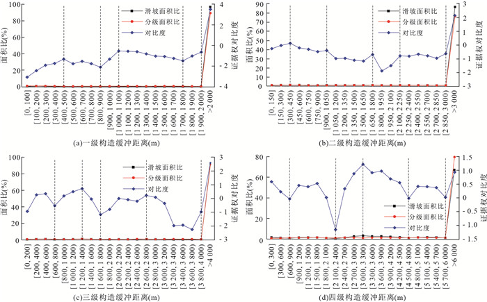
图 8 不同级别地质构造状态分级
Fig. 8. Statistical results of state classification of different geological structures
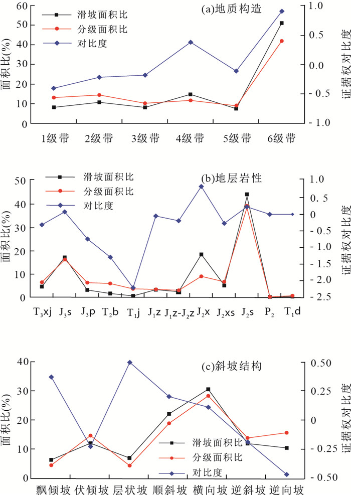
图 9 基础地质类因子状态分级统计图
Fig. 9. Statistical results of state classification of basic geology index
表 1 万州区特大型滑坡信息
Table 1. The information of super-large landslides in Wanzhou District
滑坡名称 位置 面积(104 m2) 体积(104 m3) 类型 塘角1号滑坡 陈家坝街道 115 2 900 特大型堆积体滑坡 和平广场滑坡 高笋塘街道 105 1 950 特大型堆积体滑坡 枇杷坪滑坡 钟鼓楼街道 105 5 050 特大型堆积体滑坡  下载: 导出CSV
表 2 水系影响带分级
Table 2. Classification of river system influenced region
水系 影响距离(m) 级别 1级带 2级带 3级带 4级带 1 [0, 800] (800, 1200] (1 200, 2 000] > 2000 2 > 1000 (400, 800] (800, 1000] [0, 400] 3 > 450 (300, 450] (200, 300] [0, 200] 对比度C 1.611 0.331 0.620 -0.514
下载: 导出CSV
表 3 地质构造影响带分级
Table 3. Classification of geological structure influenced region
构造 影响距离(m) 类别 1级带 2级带 3级带 4级带 5级带 6级带 1 [0, 500] (500, 900] (900, 1100] (1 800, 2 000] (1 100, 1 800] >2 000 2 (1 800, 2 250] (1 050, 1 800] (2 250, 3 000] (450, 1050] [0, 450] >3 000 3 (2 800, 4 000] (1 800, 2 800] [0, 800] (1 400, 1 800] (800, 1400] >4 000 4 (900, 2400] [4800, 6000] [0, 900] [3300, 4 800] >6 000 (2 400, 3 300] 对比度C 0.409 -0.218 -0.179 0.388 -0.110 0.919
下载: 导出CSV
表 4 因子相关性计算
Table 4. The calculation results of correlation between factors
指标因子 坡度 坡向 高程 剖面曲率 地表纹理 水系 地层岩性 地质构造 斜坡结构 土地利用 坡度(°) 1.00 坡向 0.09 1.00 高程(m) 0.16 0.10 1.00 剖面曲率 0.09 -0.18 -0.06 1.00 地表纹理 0.03 0.00 0.05 -0.02 1.00 水系(m) 0.01 -0.01 -0.03 0.01 0.00 1.00 地层岩性 -0.18 -0.01 0.01 0.01 0.00 0.02 1.00 地质构造(m) -0.13 -0.03 -0.05 -0.07 -0.01 -0.01 -0.09 1.00 斜坡结构 0.04 0.08 0.45 -0.03 0.02 -0.01 0.11 -0.11 1.00 土地利用 -0.09 0.01 0.04 -0.06 0.00 -0.01 -0.07 0.26 0.03 1.00
下载: 导出CSV
表 5 各指标因子二级状态证据权重
Table 5. Weights of evidence of states of each index factor
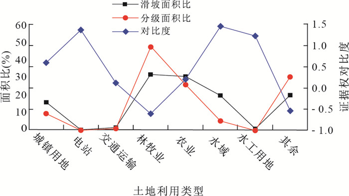
指标因子 取值 证据权重 坡度(°) 0~15 0.161 15~25 0.05 25~35 -0.308 35~45 -0.286 45~71 -0.29 坡向(°) -1 0.289 0~45 0.102 45~90 0.102 90~135 -0.087 135~180 -0.144 180~225 -0.148 225~270 0.173 270~315 0.058 315~360 -0.203 剖面曲率 凹型坡 -0.016 直线坡 0.185 凸型坡 -0.02 地表纹理 0~0.327 1.135 0.327~0.545 -0.758 0.545~0.763 -1.049 0.763~0.817 0.179 水系缓冲距离(m) 1级带 0.494 2级带 -0.786 3级带 -0.497 4级带 -1.631 地层岩性 T3xj -0.416 J3s -0.024 J3p -0.841 T2b -1.39 T1j -2.314 J1z -0.153 J1z-2z -0.295 J2x 0.733 J2xs -0.372 J2s 0.104 P2 -0.102 T1d -0.106 地质构造缓冲距离(m) 1级带 -0.409 2级带 -0.218 3级带 -0.179 4级带 0.388 5级带 -0.11 6级带 0.919 斜坡结构 飘倾坡 0.363 伏倾坡 -0.232 层状坡 0.488 顺斜坡 0.194 横向坡 0.103 逆斜坡 -0.192 逆向坡 -0.472 土地利用 城镇用地 0.652 电站 1.428 交通运输 0.179 林牧业 -0.547 农业 0.267 水域 1.517 水工用地 1.285 其余 -0.479
下载: 导出CSV
表 6 指标因子权重计算结果
Table 6. The results of weights of index factors
编号 指标因子 PSO-BP计算权重 ArcGIS输入权重 1 坡度 0.878 9 1.274 5 2 坡向 0.884 3 1.282 3 3 剖面曲率 0.756 4 1.096 9 4 地表纹理 1.108 4 1.607 3 5 水系 1.432 8 2.077 7 6 地层岩性 1.186 1 1.720 0 7 地质构造 1.128 7 1.636 7 8 斜坡结构 0.934 8 1.355 6 9 土地利用 0.689 6 1.000 0 注:ArcGIS输入权重=计算权重/最小指标因子权重.
下载: 导出CSV
表 7 栅格统计结果
Table 7. The statistical results of grids
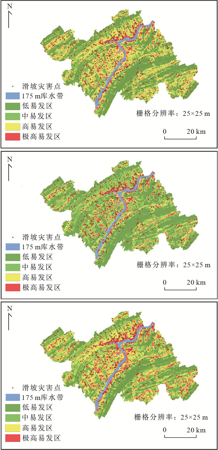
易发性等级 分级栅格数 分级比例(%) 滑坡栅格数 滑坡占总栅格比例 滑坡比例(%) 滑坡比率 低 1 801004 32.57 9 162 0.51 12.74 0.391 2 中 1 302703 23.56 10 117 0.78 14.07 0.597 2 高 1 677254 30.33 23 241 1.39 32.32 1.065 5 极高 749 196 13.55 29 399 3.92 40.88 3.017 4
下载: 导出CSV
表 8 WOE-BP模型预测正确率和错报率
Table 8. The correct rate and erroneous rate in WOE-BP model prediction
样本类型 样本数(个) 预测正确的样本数(个) 正确率(%) 预测错误的样本数(个) 错报率(%) 训练样本 10 000 8 409 84.1 880 8.8 预测样本 61 919 44 231 71.4 8 282 13.4 总样本 71 919 52 640 73.2 9 162 12.7
下载: 导出CSV
-
Agterberg, F. P., Bonham-Carter, G. F., Cheng, Q. M., et al., 1993. Weights of Evidence Modeling and Weighted Logistic Regression for Mineral Potential Mapping. Computers in Geology, 25 Years of Progress. Oxford University Press, Oxford, 13-32. Bonham-Carter, G. F., Agterberg, F. P., Wright, D. F., 1988. Integration of Geological Datasets for Cold Exploration in Nova Scotia. American Society for Photogrammetry and Remote Sensing, 54(11): 1585-1592. Cheng, Q. M., Chen, Z. J., Ali, K., 2007. Application of Fuzzy Weights of Evidence Method in Mineral Resource Assessment for Gold in Zhenyuan District, Yunnan Province, China. Earth Science, 32(2): 175-184 (in Chinese with English abstract). http://www.wanfangdata.com.cn/details/detail.do?_type=perio&id=dqkx200702004 Cheng, W. M., Peng, L., Niu, R., Q., 2013. Landslide Susceptibility Assessment Based on Rough Set Theory: Taking Zigui County Territory in Three Gorges Reservoir for Example. Journal of Central South University(Science and Technology), 44(3): 1083-1090 (in Chinese with English abstract). Devkota, K. C., Regmi, A. D., Pourghasemi, H. R., et al., 2013. Landslide Susceptibility Mapping Using Certainty Factor, Index of Entropy and Logistic Regression Models in GIS and Their Comparison at Mugling-Narayanghat Road Section in Nepal Himalaya. Natural Hazards, 65(1): 135-165. https://doi.org/10.1007/s11069-012-0347-6 Du, J., Yang, Q. H., Yan, J., et al., 2010. Hazard Evaluation of Secondary Geological Disaster Based on GIS and Information Value Method. Earth Science, 35 (2): 324-330 (in Chinese with English abstract). http://d.old.wanfangdata.com.cn/Periodical/dqkx201002018 Eberhart, R., Kennedy, J., 1995. A New Optimizer Using Particle Swarm Theory. Proceeding of the Sixth International Symposium on Micro Machine and Human Science. IEEE, Nagoya, 39-43. Fan, L. F., Hu, R. L., Zeng, F. C., et al., 2012. Application of Weighted Information Value Model to Landslide Susceptibility Assessment: A Case Study of Enshi City, Hubei Province. Journal of Engineering Geology, 20(4): 508-513 (in Chinese with English abstract). Fan, Q., Ju, N. P., Xiang, X. Q., et al., 2014. Landslides Hazards Assessment with Weights of Evidence: A Case Study in Guizhou, China. Journal of Engineering Geology, 22(3): 474-481 (in Chinese with English abstract). Fan, Q., Ju, N. P., Xiang, X. Q., et al., 2015. Application of Weights of Evidence Method in Landslide Susceptibility Zoning: A Case Study on Tongzi River Basin in Guizhou. Journal of Catastrophology, 30(1): 124-129 (in Chinese with English abstract). Feng, H. J., Zhou, A. G., Yu, J. J., et al., 2016. A Comparative Study on Plum-Rain-Triggered Landslide Susceptibility Assessment Models in West Zhejiang Province. Earth Science, 41(3): 403-415 (in Chinese with English abstract). http://www.wanfangdata.com.cn/details/detail.do?_type=perio&id=dqkx201603007 Ge, Y. F., Tang, H. M., Li, W., et al., 2016. Evaluation for Deposit Areas of Rock Avalanche Based on Features of Rock Mass Structure. Earth Science, 41(9): 1583-1592 (in Chinese with English abstract). http://d.old.wanfangdata.com.cn/Periodical/dqkx201609013 Hines, J. W., 2007. Fuzzy and Neural Approaches in Engineering. Wiley Press, New York. Huang, F. M., Yin, K. L., Huang, J. S., et al., 2017. Landslide Susceptibility Mapping Based on Self-Organizing- Map Network and Extreme Learning Machine. Engineering Geology, 223: 11-22. doi: 10.1016/j.enggeo.2017.04.013 Huang, R. Q., 2007. Large-Scale Landslides and Their Sliding Mechanisms in China since the 20th Century. Chinese Journal of Rock Mechanics and Engineering, 26(3): 433-454 (in Chinese with English abstract). http://www.wanfangdata.com.cn/details/detail.do?_type=perio&id=yslxygcxb200703001 Iqbal, J., Dai, F. C., Hong, M., et al., 2018. Failure Mechanism and Stability Analysis of an Active Landslide in the Xiangjiaba Reservoir Area, Southwest China. Journal of Earth Science, 29(3): 646-661. https://doi.org/10.1007/s12583-017-0753-5 Lee, S., Pradhan, B., 2007. Landslide Hazard Mapping at Selangor, Malaysia Using Frequency Ratio and Logistic Regression Models. Landslides, 4(1): 33-41. doi: 10.1007/s10346-006-0047-y Liu, Y. L., Yin, K. L., Liu, B., 2010. Application of Logistic Regression and Artificial Neural Networks in Spatial Assessment of Landslide Hazards. Hydrogeology and Engineering Geology, 37(5): 92-96 (in Chinese with English abstract). http://www.wanfangdata.com.cn/details/detail.do?_type=perio&id=swdzgcdz201005017 Mantovani, F., Gracia, F. J., de Cosmo, P. D., et al., 2010. A New Approach to Landslide Geomorphological Mapping Using the Open Source Software in the Olvera Area (Cadiz, Spain). Landslides, 7(1): 69-74. doi: 10.1007/s10346-009-0181-4 Migoń, P., Jancewicz, K., Różycka, M., et al., 2017. Large- Scale Slope Remodelling by Landslides-Geomorphic Diversity and Geological Controls, Kamienne Mts., Central Europe. Geomorphology, 289: 134-151. doi: 10.1016/j.geomorph.2016.09.037 Pradhan, B., 2013. A Comparative Study on the Predictive Ability of the Decision Tree, Support Vector Machine and Neuro-Fuzzy Models in Landslide Susceptibility Mapping Using GIS. Computers & Geosciences, 51: 350-365. http://www.wanfangdata.com.cn/details/detail.do?_type=perio&id=c652c43324bfb4b73bd38d99709fd144 Regmi, A. D., Devkota, K. C., Yoshida, K., et al., 2014. Application of Frequency Ratio, Statistical Index, and Weights-of-Evidence Models and Their Comparison in Landslide Susceptibility Mapping in Central Nepal Himalaya. Arabian Journal of Geosciences, 7(2): 725-742. doi: 10.1007/s12517-012-0807-z Song, S., Y., Wang, Q., Pan, Y., Z., et al., 2014. Evaluation of Landslide Susceptibility Degree Based on Catastrophe Theory. Rock and Soil Mechanics, 35(Suppl. 2):422-428 (in Chinese with English abstract). http://d.old.wanfangdata.com.cn/Periodical/ytlx2014z2060 Tang, Y., Yin, K. L., Wang, Y., et al., 2017. The Landslide Rain Infiltration Based on the Improved Mein-Larson Model. Earth Science, 42(4): 634-640 (in Chinese with English abstract). http://www.wanfangdata.com.cn/details/detail.do?_type=perio&id=dqkx201704012 Wang, J., Guo, J., Wang, W. D., et al., 2012. Application and Comparison of Weighted Linear Combination Model and Logistic Regression Model in Landslide Susceptibility Mapping. Journal of Central South University (Science and Technology), 43(5): 1932-1939 (in Chinese with English abstract). http://www.wanfangdata.com.cn/details/detail.do?_type=perio&id=zngydxxb201205050 Wang, J. J., Yin, K. L., Xiao, L. L., 2014. Landslide Susceptibility Assessment Based on GIS and Weighted Information Value: A Case Study of Wanzhou District, Three Gorges Reservoir. Chinese Journal of Rock Mechanics and Engineering, 33(4): 797-808 (in Chinese with English abstract). Wang, Z. W., Li, D.Y., Wang, X. G., 2007. Zonation of Landslide Hazards Based on Weights of Evidence Model. Chinese Journal of Geotechnical of Engineering, 29(8): 1268-1273 (in Chinese with English abstract). Wu, X. L., Ren, F., Niu, R. Q., 2014. Landslide Susceptibility Assessment Using Object Mapping Units, Decision Tree, and Support Vector Machine Models in the Three Gorges of China. Environmental Earth Sciences, 71(11): 4725-4738. doi: 10.1007/s12665-013-2863-4 Wu, Y. P., Tang, H. M., Ge, X. R., 2005. Application of BP Model to Landslide Hazard Risk Prediction. Rock and Soil Mechanics, 26(9): 1409-1413 (in Chinese with English abstract). http://www.wanfangdata.com.cn/details/detail.do?_type=perio&id=ytlx200509012 Wu, Y. P., Zhang, Q. X., Tang, H. M., et al., 2014. Landslide Hazard Warning Based on Effective Rainfall Intensity. Earth Science, 39(7): 889-895 (in Chinese with English abstract). Xu, C., Dai, F. C., Xu, X. W., 2011. Earthquake Triggered Landslides Susceptibility Evaluation Based on GIS Platform and Weight-of-Evidence Modeling. Earth Science, 36(6): 1155-1164 (in Chinese with English abstract). Yalcin, A., Reis, S., Aydinoglu, A. C., et al., 2011. A GIS- Based Comparative Study of Frequency Ratio, Analytical Hierarchy Process, Bivariate Statistics and Logistics Regression Methods for Landslide Susceptibility Mapping in Trabzon, NE Turkey. Catena, 85(3): 274-287. doi: 10.1016/j.catena.2011.01.014 Zhang, J., 2016. Landslide Risk Assessment in Wanzhou County, Three Gorges Reservoir(Dissertation). China University of Geosciences, Wuhan (in Chinese with English abstract). Zhang, J., Yin, K. L., Wang, J. J., et al., 2016. Evaluation of Landslide Susceptibility for Wanzhou District of Three Gorges Reservoir. Chinese Journal of Rock Mechanics and Engineering, 35(2): 284-296 (in Chinese with English abstract). http://www.wanfangdata.com.cn/details/detail.do?_type=perio&id=yslxygcxb201602009 Zhang, T. L., Zhou A. G., Sun, Q., et al., 2017. Characteristics of the Groundwater Seepage and Failure Mechanisms of Landslide Induced by Typhoon Rainstorm. Earth Science, 42(12): 2354-2362 (in Chinese with English abstract). http://www.wanfangdata.com.cn/details/detail.do?_type=perio&id=dqkx201712018 Zhou, W. Y., 1999. Verification of the Nonparametric Characteristics of Back Propagation Neural Networks for Image Classification. IEEE Transactions on Geoscience and Remote Sensing, 37(2): 771-779. doi: 10.1109/36.752193 成秋明, 陈志军, Ali, K., 2007.模糊证据权方法在镇沅(老王寨)地区金矿资源评价中的应用.地球科学, 32(2): 175-184. doi: 10.3321/j.issn:1000-2383.2007.02.004 程温鸣, 彭令, 牛瑞卿, 2013.基于粗糙集理论的滑坡易发性评价—以三峡库区秭归县境内为例.中南大学学报(自然科学版), 44(3): 1083-1090. http://www.wanfangdata.com.cn/details/detail.do?_type=perio&id=zngydxxb201303033 杜军, 杨青华, 严嘉, 等, 2010.基于GIS与信息量模型的汶川次生地质灾害危险性评价.地球科学, 35(2): 324-330. doi: 10.3799/dqkx.2010.034 范林峰, 胡瑞林, 曾逢春, 等, 2012.加权信息量模型在滑坡易发性评价中的应用:以湖北省恩施市为例.工程地质学报, 20(4): 508-513. doi: 10.3969/j.issn.1004-9665.2012.04.005 范强, 巨能攀, 向喜琼, 等, 2014.证据权法在区域滑坡危险性评价中的应用:以贵州省为例.工程地质学报, 22(3): 474-481. http://d.old.wanfangdata.com.cn/Periodical/gcdzxb201403022 范强, 巨能攀, 向喜琼, 等, 2015.证据权法在滑坡易发性分区中的应用:以贵州桐梓河流域为例.灾害学, 30(1): 124-129. doi: 10.3969/j.issn.1000-811X.2015.01.024 冯杭建, 周爱国, 俞剑君, 等, 2016.浙江梅雨滑坡易变性评价模型对比.地球科学, 41(3): 403-415. doi: 10.3799/dqkx.2016.032 葛云峰, 唐辉明, 李伟, 等, 2016.基于岩体结构特征的高速远程滑坡致灾范围评价.地球科学, 41(9): 1583-1592. doi: 10.3799/dqkx.2016.117 黄润秋, 2007.20世纪以来中国的大型滑坡及其发生机制.岩石力学与工程学报, 26(3): 433-454. doi: 10.3321/j.issn:1000-6915.2007.03.001 刘艺梁, 殷坤龙, 刘斌, 2010.逻辑回归和人工神经网络模型在滑坡灾害空间预测中的应用.水文地质工程地质, 37(5): 92-96. doi: 10.3969/j.issn.1000-3665.2010.05.017 宋盛渊, 王清, 潘玉珍, 等, 2014.基于突变理论的滑坡危险性评价.岩土力学, 35(增刊2): 422-428. http://d.old.wanfangdata.com.cn/Periodical/ytlx2014z2060 唐扬, 殷坤龙, 汪洋, 等, 2017.斜坡降雨入渗的改进Mein-Larson模型.地球科学, 42(4): 634-640. doi: 10.3799/dqkx.2017.050 王进, 郭靖, 王卫东, 等, 2012.权重线性组合与逻辑回归模型在滑坡易发性区划中的应用与比较.中南大学学报(自然科学版), 43(5): 1932-1939. http://www.wanfangdata.com.cn/details/detail.do?_type=perio&id=zngydxxb201205050 王佳佳, 殷坤龙, 肖莉丽, 2014.基于GIS和信息量的滑坡灾害易发性评价:以三峡库区万州区为例.岩石力学与工程学报, 33(4): 797-808. http://d.old.wanfangdata.com.cn/Periodical/yslxygcxb201404018 王志旺, 李端有, 王湘桂, 2007.证据权法在滑坡危险度区划研究中的应用.岩土工程学报, 29(8): 1268-1273. doi: 10.3321/j.issn:1000-4548.2007.08.026 吴益平, 唐辉明, 葛修润, 2005. BP模型在区域滑坡灾害风险预测中的应用.岩土力学, 26(9): 1409-1413. doi: 10.3969/j.issn.1000-7598.2005.09.012 吴益平, 张秋霞, 唐辉明, 等, 2014.基于有效降雨强度的滑坡灾害危险性预警.地球科学, 39(7): 889-895. doi: 10.3799/dqkx.2014.083 许冲, 戴福初, 徐锡伟, 2011.基于GIS平台与证据权的地震滑坡易发性评价.地球科学, 36(6): 1155-1164. http://www.earth-science.net/article/id/2192 张俊, 2016.三峡库区万州区滑坡灾害风险评估研究(硕士学位论文).武汉: 中国地质大学. 张俊, 殷坤龙, 王佳佳, 等, 2016.三峡库区万州区滑坡灾害易发性评价研究.岩石力学与工程学报, 35(2): 284-296. http://www.wanfangdata.com.cn/details/detail.do?_type=perio&id=yslxygcxb201602009 张泰丽, 周爱国, 孙强, 等, 2017.台风暴雨条件下滑坡地下水渗流特征及成因机制.地球科学, 42(12): 2354-2362. doi: 10.3799/dqkx.2017.570 -

 点击查看大图
计量
- 文章访问数: 6481
- HTML全文浏览量: 2343
- PDF下载量: 160
- 被引次数: 0
