


Topographic Correction Method for High Spatial Resolution Remote Sensing Data in Mountainous Area
-
摘要: 山区地形复杂,遥感影像地形效应明显,易造成"同物异谱"、"同谱异物"现象,增大了遥感地质填图的难度.但前人对适用于复杂地形条件下地质填图的地形校正模型讨论较少,特别是校正高空间分辨率遥感影像时多缺少对应高精度数字高程模型,校正结果易受地形异常影响.在Richter"山区"校正模型基础上引入地形抹平模型,提出"Smoothed山区"校正方法,并与另14种地形校正模型在GF-1、GF-2、SPOT6山区影像上进行对比实验.结果显示,"Smoothed山区"校正模型在山区高空间分辨率遥感影像的校正效果明显优于其他模型,校正结果地形效应减弱,影像信息丰富不失真,并且直接获取地表反射率数据,可为进一步的遥感蚀变提取等工作提供基础数据.该模型适用于复杂地形山区的遥感地质填图.Abstract: With complex terrain and steep slopes, sharp orographic effect occurs in mountainous areas which obviously increases the difficulty of remote sensing geological mapping by the phenomenon of "different bodies with same spectrums" or "same body with different spectrums". Although several Topographic correction (TOC) methods have been proposed and applied to vegetationcovered area and snowfield successfully in the last decades, there is little discussion on topographic correction models for geological mapping under complex topographic conditions, which have totally different application environment since the uncovered geological bodies of mountainous areas have bigger spatial variability. Especially in the correction of high spatial resolution remote sensing images, the corresponding high-precision Digital Elevation Model (DEM) is often absent, and the correction results are vulnerable to topographic anomalies. This paper proposes a "Smoothed Mountains" correction method, which combines Richter "Mountains" correction model with terrain smoothing model. GF-1, GF-2 and SPOT6 mountain images obtained by this model have been compared with those by other 14 terrain correction models. The results show that the stability and correction effect of the "Smoothed Mountains" correction model are obviously better than other models. The correction images show that the terrain effect is weakened, and the image information is rich and undistorted. Moreover, the surface reflectance data can be obtained directly, which provides basic data for further remote sensing alteration extraction. Therefore, the "Smoothed Mountains" model could be a practical and feasible TOC model in remote sensing geological mapping over steep mountain terrain.
-

图 1 实验区1坡度直方图(a)与地形抹平后坡度直方图(b)
Fig. 1. Histogram of study surface slope (a) and histogram of surface slope by smoothed terrain in study area 1 (b)
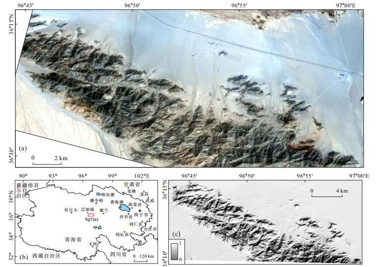
图 3 地形校正前实验区1 GF-1 3(R), 2(G)1(B)波段组合影像(a)、实验区1地理位置示意图(b)及地形阴影图(c)
Fig. 3. Composite of GF-1 bands 3, 2 and 1in study area 1(before topographic correction) (a), Geographical location sketch map of study area (b), Topographic hill-shade map (c).
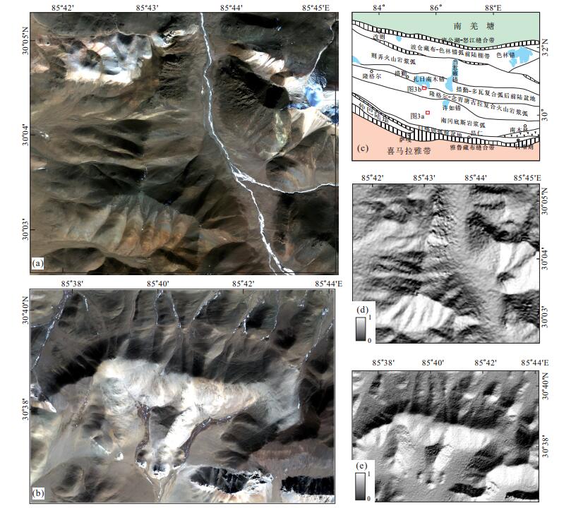
图 4 地形校正前实验区2 GF-2 3(R), 2(G)1(B)波段组合影像(a)、实验区3 SPOT63(R), 2(G)1(B)波段组合影像(b)、实验区2与实验区3地理位置示意图(c)、及地形阴影图(d, e)
Fig. 4. Composite of GF-2 bands 3, 2 and 1 in study area 2 (before topographic correction) (a), Composite of SPOT6 bands 3, 2 and 1 in study area 1 (before topographic correction) (b), Geographical location sketch map of study area-2 and area-3 (c), Topographic hill-shade map (d, e)
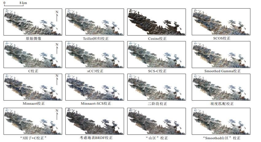
图 5 实验区1地形校正前后影像对比[GF-1 3(R), 2(G), 1(B)1%线性拉伸]
Fig. 5. Original and corrected images in study area 1 with different topographic correction models
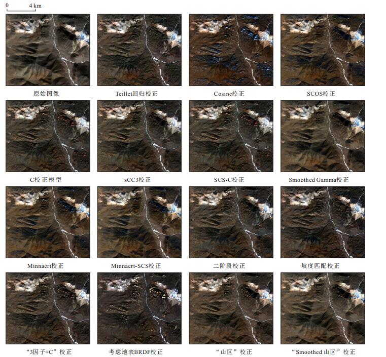
图 6 实验区2地形校正前后影像对比[GF-2 3(R), 2(G), 1(B)线性1%拉伸]
Fig. 6. Original and corrected images in study area 2 with different topographic correction models
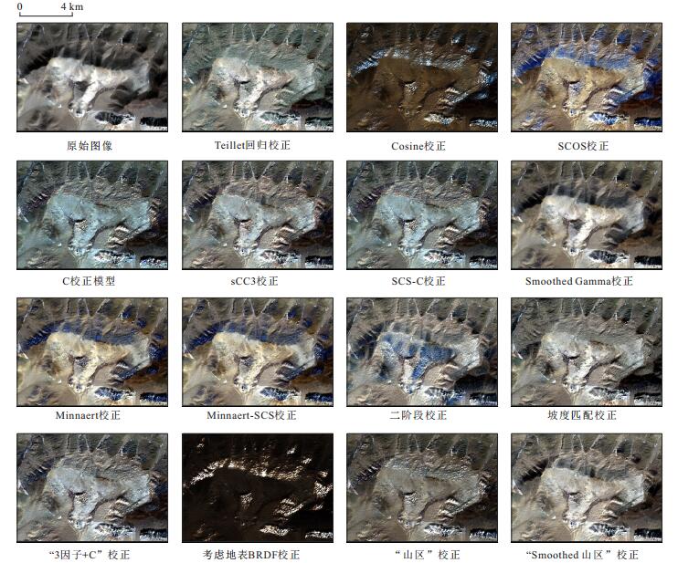
图 7 实验区3地形校正前后影像对比[SPOT6 3(R), 2(G), 1(B)1%线性拉伸]
Fig. 7. Original and corrected images in study area 3 with different topographic correction models
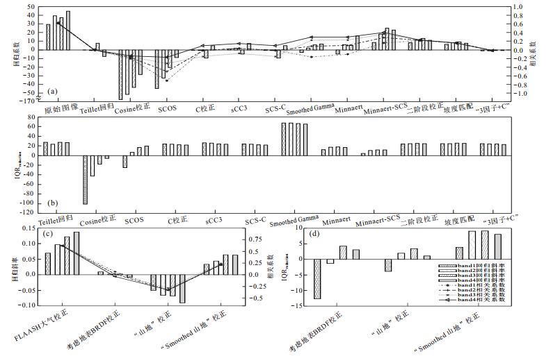
图 8 实验区1地形校正后GF-1各波段辐射度与cosis 的回归斜率和相关系数(a、c)、地形校正后GF-1各波段辐射度四分位距减少量(b, d)
Fig. 8. Slope and correlation coefficient of regression between cosis and the radiance of each spectral band of GF-1 after topographic correction in study area-1(a, c); Intraclass IQR reduction of each spectral band of GF-1 after topographic correction in study area-1(b, d)
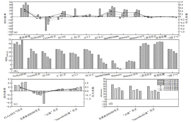
图 9 实验区2地形校正后GF-2各波段辐射度与cosis 的回归斜率和相关系数(a、c)、地形校正后GF-1各波段辐射度四分位距减少量(b, d)
Fig. 9. Slope and correlation coefficient of regression between cosis and the radiance of each spectral band of GF-2 after topographic correction in study area-2(a, c); Intraclass IQR reduction of each spectral band of GF-1 after topographic correction in study area-2(b, d)
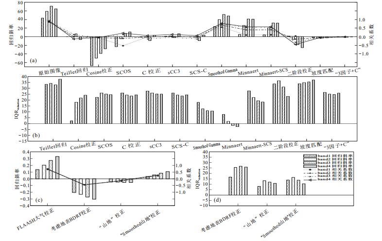
图 10 实验区3地形校正后SPOT6各波段辐射度与cosis 的回归斜率和相关系数(a、c)、地形校正后SPOT6各波段辐射度四分位距减少量(b, d)
Fig. 10. Slope and correlation coefficient of regression between cosis and the radiance of each spectral band of SPOT6 after topographic correction in study area-3(a, c); Intraclass IQR reduction of each spectral band of SPOT6 after topographic correction in study area-3(b, d)
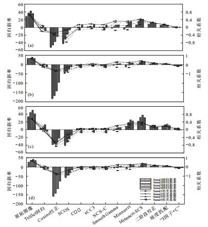
图 11 实验区1内4个岩体地形校正后GF-1各波段辐射度与cosis 的回归斜率和相关系数
Fig. 11. Slope and correlation coefficient of regression between cosis and the radiance of each spectral band of GF-1 after topographic correctionfor the 4 rocks in study area-1
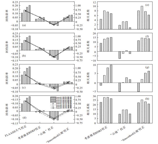
图 13 实验区1内4个岩体地形校正后GF-1各波段辐射度与cosis 的回归斜率和相关系数(a、b、c、d)、地形校正后GF-1各波段辐射度四分位距减少量(e、f、g、h)
Fig. 13. Slope and correlation coefficient of regression between cosis and the radiance of each spectral band of GF-1 after topographic correction Image for the4 rocks in study area-1 (a, b, c, d); Intraclass IQR reduction of each spectral band of GF-1 after topographic correction for the 4 rocks in study area-1 (e, f, g, h)
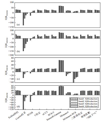
图 12 实验区1内4个岩体地形校正后GF-1各波段辐射度四分位距减少量
Fig. 12. Intraclass IQR reduction of each spectral band of GF-1 after topographic correction for the 4 rocks in study area-1
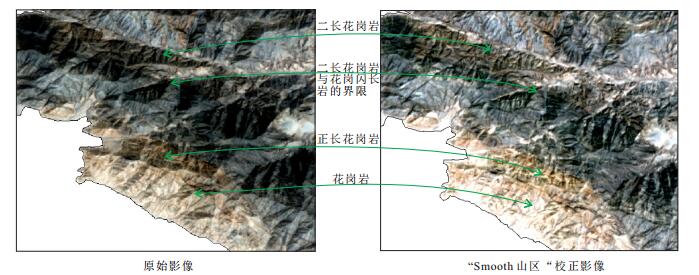
图 14 实验区1“Smoothed山区”校正前后影像对比
Fig. 14. Image of the study area 1 before and after "Smooth Mountains" correction models
表 1 地形校正模型及其算法表达式
Table 1. algorithm Expressions of topographic correction methods
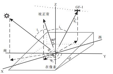
校正模型 算法公式 参考文献 校正模型 算法公式 参考文献 Teillet-回归 $ {L}_{\text{corr}, \mathtt{λ }}={{L}_{\lambda }}-a\cdot \text{cos}{{i}_{s}}-b+\overline{{{L}_{\mathtt{λ }}}}$ Teillet et al.(1982) Cosine ${{L}_{\text{corr}, \mathtt{λ }}}={{L}_{\lambda }}\frac{\text{cos}{{\theta }_{z}}}{\text{cos}{{i}_{s}}}$ Teillet et al.(1982) C ${{L}_{\text{corr}, \mathtt{λ }}}={{L}_{\lambda }}\frac{{cos}{{\theta }_{z}}+{{C}_{\mathtt{λ }}}}{\text{cos}{{i}_{s}}+{{C}_{\mathtt{λ }}}}$ Teillet et al.(1982) SCOS ${{L}_{\text{corr}, \mathtt{λ }}}={{L}_{\lambda }}\frac{\text{cos}{{\theta }_{z}}}{\text{cos}i{{'}_{s}}}$ 姜亢等(2014) sCC3 ${{L}_{\text{corr}, \mathtt{λ }}}={{L}_{\lambda }}\frac{{cos}{{\theta }_{z}}+{{C}_{\mathtt{λ }}}}{\text{cos}i{{'}_{s}}+{{C}_{\mathtt{λ }}}}$ Riano et al.(2003) Minnaert ${{L}_{\text{corr}, \mathtt{λ }}}={{L}_{\lambda }}\frac{\text{cos}\alpha }{\text{co}{{\text{s}}^{\text{k}}}{{i}_{\text{s}}}\cdot \text{co}{{\text{s}}^{\text{k}}}\alpha }$ Smith et al.(1980) SCS-C ${{L}_{\text{corr}, \mathtt{λ }}}={{L}_{\mathtt{λ }}}\frac{{cos}{{\theta }_{z}}cos\mathtt{α}+{{C}_{\mathtt{λ }}}}{\text{cos}{{i}_{s}}+{{C}_{\mathtt{λ }}}}$ Scott et al. (2005) Minnaert-SCS ${{L}_{\text{corr}, \mathtt{λ }}}={{L}_{\lambda }}\frac{\text{co}{{\text{s}}^{\text{k}}}{{\theta }_{z}}\text{cos}\alpha }{\text{co}{{\text{s}}^{\text{k}}}{{i}_{s}}}$ Vincini et al.(2002) Smoothed Gamma ${{L}_{\text{corr}, \mathtt{λ }}}={{L}_{\mathtt{λ }}}\frac{{cos}{{\theta }_{z}}+\text{cos}{{\theta }_{v}}}{\text{cos}i{{'}_{s}}+\text{cos}i{{'}_{v}}}$ 本文 二阶段校正 1步:${{L}_{\text{first}}}={{L}_{\lambda }}+{{L}_{\lambda }}\left(\frac{{{\mu }_{k}}-{{X}_{ij}}}{{{\mu }_{k}}} \right)$;2步:${{L}_{\text{corr, }\mathtt{λ }}}={{L}_{\lambda }}+{{L}_{\lambda }}\left(\frac{{{\mu }_{k}}-{{X}_{ij}}}{{{\mu }_{k}}} \right)\begin{array}{*{35}{l}} {{C}_{\text{2sn}}} \\ \end{array}$ Civco(1989) 坡度匹配 1步:${{L}_{\text{first}}}={{L}_{\lambda }}+\left({{L}_{\text{max}, \mathtt{λ }}}-{{L}_{\text{min}, \mathtt{λ }}} \right)\left(\frac{{{\mu }_{w}}-{{X}_{ij}}}{{{\mu }_{w}}} \right)$; 2步:${{L}_{\text{corr}, \mathtt{λ }}}={{L}_{\lambda }}+\left({{L}_{\text{max}, \mathtt{λ }}}-{{L}_{\text{min}, \mathtt{λ }}} \right)\left(\frac{{{\mu }_{w}}-{{X}_{ij}}}{{{\mu }_{w}}} \right){{C}_{2\text{sm}}}$ Nichol et al. (2006) 3因子+C ${{L}_{\text{corr}, \mathtt{λ }}}={{L}_{\mathtt{λ }}}\left\{ \frac{\text{cos}{{\theta }_{z}}+\frac{1-T\left(\lambda, \theta \right)}{2T\left(\lambda, \theta \right)}+{{C}_{\mathtt{λ }}}}{\left(1+\left(1-{{V}_{\text{sky}}}\left(x, y \right) \right)\mathtt{ρ}_{\text{terrain}}^{\left(i-1 \right)} \right)\left\{ \Phi \left(x, y \right)\text{cos}{{i}_{\text{s}}}+\frac{1-T\left(\lambda, \theta \right)}{2}\left[ \text{cos}{{i}_{s}}+\left(1/T\left(\lambda, \theta \right)-\text{cos}{{\theta }_{z}} \right){{V}_{\text{sky}}}\left(x, y \right) \right]+{{C}_{\mathtt{λ }}} \right\}} \right\}$ Zhang and Gao(2011), 张伟阁等(2015) 考虑地表BRDF校正 $ {{\mathtt{ρ}}_{\text{corr}, \mathtt{λ }}}=\frac{\pi \cdot\left[L_{\lambda}-L_\text{p}\right] / \tau_\text{u p}}{\mathtt{ɸ}(x, y) \frac{\left(E_\text{d i r}+E_\text{d i l} \tau_\text{d o m n}\right) \cos i_{s}}{\cos \theta_{s}} \frac{\Omega\left(i_{s}, i_{v}, \varphi\right)}{\Omega\left(\theta_{s}, \theta_{v}, \varphi\right)}+\frac{\left[E_\text{dif}\left(1-\mathtt{ɸ}(x, y)(x, y) \tau_\text{d o w n}\right) V_\text{s ky}(x, y)+E_\text{iter}^{(i)}\right]}{\pi \Omega\left(\theta_{s}, \theta_{v}, \varphi\right)} \int_{0}^{2 \pi} \int_{0}^{\pi / 2} \Omega\left(i_{s}, i_{v}, \varphi\right) \text{d} \Omega_{i}}$ 闻建光等(2007); 蒋璐媛等(2015) “山区”校正 ${{\mathtt{ρ}}_{\text{corr}, \mathtt{λ }}}=\frac{\mathtt{π}\left[ {{\text{d}}^{2}}{{L}_{\lambda }}-{{L}_{\text{min}, \mathtt{λ }}} \right]}{{{\mathtt{τ }}_{\text{up}}}\left\{ \Phi \left(x, y \right){{E}_{\text{dir}}}\text{cos}{{i}_{s}}+{{E}_{\text{dif}}}\left[ \Phi \left(x, y \right){{\mathtt{τ }}_{\text{down}}}\frac{\text{cos}{{i}_{s}}}{\text{cos}{{\theta }_{z}}}+\left(1-\Phi \left(x, y \right){{\mathtt{τ }}_{\text{down}}} \right){{V}_{\text{sky}}}\left(x, y \right) \right]+E_{\text{iter}}^{\left(i \right)} \right\}} $ Richter(1998); 宋丽瑶等(2017)  下载: 导出CSV
-
Blesius, L., Weirich, F., 2005. The Use of the Minnaert Correction for Land-Cover Classification in Mountainous Terrain. International Journal of Remote Sensing, 26(17):3831-3851. https://doi.org/10.1080/01431160500104194 Civco, D. L., 1989. Topographic Normalization of Landsat Thematic Mapper Digital Imagery. Photogrammetric Engineering & Remote Sensing, 55(9):1303-1309. Cooley, T., Anderson, G. P., Felde, G. W., et al., 2002. FLAASH, a MODTRAN4-Based Atmospheric Correction Algorithm, Its Application and Validation. IEEE international Geoscience and Remote SensingSymposium, 3:1414-1418. https://doi.org/10.1109/IGARSS.2002.1026134 Ding, Y. F., You, H. J., Zhang, H., et al., 2018. Topographic Correction Method for High-Resolution Remote Sensing Images. Journal of Being University of Aeronautics and Astronautics, 44(1): 27-35(in Chinese with English abstract). Duan, S. B., Yan, G. J., 2007. A Review of Models for TopoGraphic Correction of Remotely Sensed Images in Mountainous Area. Journal of Beijing Normal University: Natural Science, 43(3): 362-366(in Chinese with English abstract). http://www.wanfangdata.com.cn/details/detail.do?_type=perio&id=bjsfdxxb200703025 Duan, S. B., Yan, J. G., Mu, X. H., et al., 2007. DEM Based Remote Sensed Imagery Topographic Correction Method in Mountainous Areas. Geography and Geo-Information Science, 23(6): 18-22 (in Chinese with English abstract). http://www.wanfangdata.com.cn/details/detail.do?_type=perio&id=750d09b753115dcf77498a41771ca260 Dymond, J. R., Shepherd, J. D., 1999. Correction of the Topographic Effect in Remote Sensing. IEEE Transactions on Geoscience and Remote Sensing, 37(5): 2618-2619. https://doi.org/10.1109/36.789656 Gao, Y. N., Zhang, W. C., 2008a. Comparison Test and Research Progress of Topographic Correction on Remotely Sensed Data. Geographical Research, 27(2): 467-477(in Chinese with English abstract). http://www.wanfangdata.com.cn/details/detail.do?_type=perio&id=dlyj200802024 Gao, Y. N., Zhang, W. C., 2008b. Simplification and Modification of a Physical Topographic Correction Algorithm for Remotely Sensed Data. Acta Geodaetica et Cartographica Sinica, 37(1): 89-94(in Chinese with English abstract). http://www.wanfangdata.com.cn/details/detail.do?_type=perio&id=chxb200801016 Gao, Y.N., Zhang, W.C., 2009. A Simple Empirical Topographic Correction Method for ETM Plus Imagery. International Journal of Remote Sensing, 30(9): 2259-2275 (in Chinese with English abstract). doi: 10.1080/01431160802549336 Gou, Z. B., Liu, H., Li, J., et al., 2018. The Petrogenesis and Tectonic Significance of Early Cretaceous Volcanic Rocks in Nixiong Area from the Central and Northern Lhasa Terrane. Earth Science, 43(8):2780-2794. (in Chinese with English abstract). http://d.old.wanfangdata.com.cn/Periodical/dqkx201808018 Gu, D. G., Gillespie, A., 1998. Topographic Normalization of Landsat TM Images of Forest Based on Subpixel Sun-Canopy-Sensor Geometry. Remote Sensing of Environment, 64(2): 166-175. doi: 10.1016/S0034-4257(97)00177-6 He, K. T., Gan, P. P., Wang, Y. J., 2009. The Extraction of Geological Micro-Structure and Altered Rock Information with High-Resolution Satellite Images in a Small Range. Remote Sensing For Land and Resources, 21(1):97-99 (in Chinese with English abstract). http://www.wanfangdata.com.cn/details/detail.do?_type=perio&id=gtzyyg200901023 Huang, W., Zhang, L. P., Li, X. P., 2005. An Improved Topographic Correction Approach for Satellite Image. Journal of Image and Graphics, 10(9): 1124-1128(in Chinese with English abstract). http://www.wanfangdata.com.cn/details/detail.do?_type=perio&id=zgtxtxxb-a200509009 Ion, S., María, G. A., Jesús, Á., M., 2016.Multi-Criteria Evaluation of Topographic Correction Methods. Remote Sensing of Environment, 184: 247-262. https://doi.org/10.1016/j.rse.2016.07.002 Jiang, K., Hu, C. M., Yu, K., et al., 2014. Landsat TM/ETM+Topographic Correction Method Based on Smoothed Terrain and Semi-Empirical Model. Journal of Remote Sensing, 18(2): 287-306 (in Chinese with English abstract). http://www.wanfangdata.com.cn/details/detail.do?_type=perio&id=ygxb201402004 Jiang, L. Y., Xiao, P. F., Feng, X. Z., et al., 2015. Calculation of Snow Reflectance from GF-1 Satellite Image in Rugged Mountain Areas. Journal of Nanjing University(Natural Sciences), 51(5):944-954 (in Chinese with English abstract). http://www.wanfangdata.com.cn/details/detail.do?_type=perio&id=njdxxb201505005 Kotchenova, S. Y., Vermote, E. F., 2007. Validation of a Vector Version of the 6S Radiative Transfer Code for Atmospheric Correction of Satellite Data Part II Homogeneous Lambertian and Anisotropic Surfaces. Applied Optics, 46(20): 4455. https://doi.org/10.1364/ao.46.004455 Law, K. H., Nichol, J., 2004. Topographic Correction for Differential Illumination Effects on iKONOS Satellite Imagery. Int. Arch. Photogramm. Remote Sens. Spat. Inform. Sci., 641-646. http://www.wanfangdata.com.cn/details/detail.do?_type=perio&id=CC0211211548 Li, A. N., Wang, Q. F., Bian, J. H., et al., 2015. An Improved Physics-Based Model for Topographic Correction of Landsat TM Images. Remote Sensing, 7(5): 6296-6319. https://doi.org/10.3390/rs70506296 Li, Y.X., Li, G.M., Xie, Y.L., et al., 2018. Properties and Evolution Path of Ore-Forming Fluid in Qiagong Polymetallic Deposit of Middle Gangdese in Tibet, China. Earth Science, 43(8):2684-2700. (in Chinese with English abstract). http://d.old.wanfangdata.com.cn/Periodical/dqkx201808011 Liu, H., Zhang, L. K., Huang, H. X., et al., 2018. Origin and Evolution of Ore-Forming Fluids in Luerma Porphyry Copper Deposit from the Western Gangdise. Earth Science.(in Chinese with English abstract). http://en.cnki.com.cn/Article_en/CJFDTotal-DQKX201906014.htm Minnaert, M., 1941. The Reciprocity Principle in Lunar Photometry. The Astrophysical Journal, 93: 403. https://doi.org/10.1086/144279 Nichol, J., Hang, L. K., Sing, W. M., 2006. Empirical Correction of Low Sun Angle Images in Steeply Sloping Terrain: A Slope-Matching Technique. International Journal of Remote Sensing, 27(3): 629-635. https://doi.org/10.1080/02781070500293414 Oke, T.R., 1987. Boundary Layer Climates. Routledge, London and New York, 405-410. Pan, G.T., Xiao, Q.H., Lu, S.N., et al., 2009. Subdivision of Tectonic Units in China. Geology in China, 36(1):1-28.(in Chinese with English abstract). http://d.old.wanfangdata.com.cn/Periodical/zgdizhi201804003 Proy, C., Tanre, D., Deschamps, P., 1989. Evaluation of Topographic Effects in Remotely Sensed Data. Remote Sensing of Environment, 30(1): 21-32. https://doi.org/10.1016/0034-4257(89)90044-8 Pu, R. L., Gong, P., 2000. Hyperspectral Remote Sensing and Its Application. Higher Education Press, Beijing, 47-80. Riano, D., Chuvieco, E., Salas, J., et al., 2003. Assessment of Different Topographic Corrections in Landsat-TM Data for Mapping Vegetation Types (2003). IEEE Transactions on Geoscience and Remote Sensing, 41(5): 1056-1061. https://doi.org/10.1109/tgrs.2003.811693 Richter, R., 1998. Correction of Satellite Imagery over Mountainous Terrain. Applied Optics, 37(18): 4004. https://doi.org/10.1364/ao.37.004004 Richter, R., Kellenberger, T., Kaufmann, H., 2009. Comparison of Topographic Correction Methods. Remote Sensing, 1(3): 184-196. https://doi.org/10.3390/rs1030184 Richter, R., Schläpfer, D., 2002. Geo-Atmospheric Processing of Airborne Imaging Spectrometry Data. Part 2: Atmospheric/topographic Correction. International Journal of Remote Sensing, 23(13): 2631-2649. https://doi.org/10.1080/01431160110115834 Sandmeier, S., Itten, K. I., 1997. A Physically-Based Model to Correct Atmospheric and Illumination Effects in Optical Satellite Data of Rugged Terrain. IEEE Transactions on Geoscience and Remote Sensing, 35(3): 708-717. https://doi.org/10.1109/36.581991 Scott, A. S., Derek, R., Craig, A. C., 2005. SCS +C : A modified Sun-Canopy-Sensor Topographic Correction in Forested Terrain. IEEE Transaction on Geoscience and Remote Sensing, 43(9):2148-2159. https://doi.org/10.1109/TGRS.2005.852480 Smith, J. A., Lin, T. L., Ranson, K. J., 1980. The Lambertian Assumption and Landsat Data. Photogrammetric Engineering & Remote Sensing, 46(9):1183-1189. http://www.cabdirect.org/abstracts/19800667141.html Song, L. Y., Zhang, H., Lin, F., 2017. Impact and Analysis of Shadow Area Extracting to the Terrain Radiation Correction for High Resolution Image. Bulletin of Surveying and Mapping, (3):29-33 (in Chinese with English abstract). http://d.old.wanfangdata.com.cn/Periodical/chtb201703008 Szantoi, Z., Simonetti, D., 2013. Fast and Robust Topographic Correction Method for Medium Resolution Satellite Imagery Using a Stratified Approach. IEEE Journal of Selected Topics in Applied Earth Observations and Remote Sensing, 6(4): 1921-1933. https://doi.org/10.1109/jstars.2012.2229260 Teillet, P. M., Guindon, B., Goodenough, D. G., 1982. On the Slope-Aspect Correction of Multispectral Scanner Data. Canadian Journal of Remote Sensing, 8(2): 84-106. https://doi.org/10.1080/07038992.1982.10855028 Tokola, T., Sarkeala, J., Van Der Linden, M., 2001. Use of Topographic Correction in Landsat TM-Based Forest Interpretation in Nepal. International Journal of Remote Sensing, 22(4): 551-563. https://doi.org/10.1080/01431160050505856 Tong, Q. X., Zhang, B., Zheng, L. F., 2006. Hyperspectral Remote Sensing and Its Multidisciplinary Applications. Publishing House of Electronics Industry, Beijing, 153-177. Vincini, M., Reeder, D., Frazzi, E., 2002. An Empirical Topographic Normalization Method for Forest TM Data. IEEE Transactions on Geoscience and Remote Sensing, 4(4): 2091-2093. https://doi.org/10.1109/IGARSS.2002.1026454 Wang, J. G., Feng, X. Z., Xiao, P. F., et al., 2018. Snow Grain-Size Estimation over Mountainous Areas from MODIS Imagery. IEEE Geoscience and Remote Sensing Letters, 15(1): 97-101. doi: 10.1109/LGRS.2017.2775207 Wang, R. S., Xiong, S. Q., Nie, H. F., et al., 2001. Remote Sensing Technology and its Application in Geological Exploration. Acta Geologica Sinica. 85(11):1699-1744 (in Chinese with English abstract). http://d.old.wanfangdata.com.cn/OAPaper/oai_doaj-articles_a306b0564393f5bccaf8dcf876afb8ca Wang, Z. H., Lin, W. L., Ding, R. X., 2017. Quantitative Measurement of Bedding Orientation Using Remote Sensing Data: Yili Basin, Northwest China. Journal of Earth Science, 29(3): 689-694. https://doi.org/10.1007/s12583-017-0943-1 Wen, J. G., Liu, Q. H., Xiao, Q., 2007. Assessment of Different Topographic Correction Methods and Validation. Journal of Beijing Normal University: Natural Science, 43(3):255-263 (in Chinese with English abstract). http://www.wanfangdata.com.cn/details/detail.do?_type=perio&id=bjsfdxxb200703007 Xu, C. K., Liu, S. B., Zhao, Z. J., et al., 2012. Metallogenic Law and Prospect Direction of Iron Deposits in the East Kunlun Metallogenic Belt in Qinghai. Acta Geologica Sinica. 86(10):1621-1678 (in Chinese with English abstract). http://www.wanfangdata.com.cn/details/detail.do?_type=perio&id=dizhixb201210006 Zang, X., Yang, B., Qi, J. W., et al., 2015. An Improved Topographic Correction Method of Remote-Sensing Images. Bulletin of Surveying and Mapping, (1):75-80 (in Chinese with English abstract). http://d.old.wanfangdata.com.cn/Periodical/chtb201501015 Zhang, K., Ma, S. B., Li, Z. R., et al., 2016.Geological Interpretation of GF-1 Satellite Imagery. Remote Sensing Information, (1): 115-123 (in Chinese with English abstract). http://en.cnki.com.cn/Article_en/CJFDTOTAL-YGXX201601019.htm Zhang, W. C., Gao, Y. N., 2011. Topographic Correction Algorithm for Remotely Sensed Data Accounting for Indirect Irradiance. International Journal of Remote Sensing, 32(7): 1807-1824. https://doi.org/10.1080/01431161003623441 Zhang, W.G., Yang, L., Cao, L.Z, et al., 2015. An Improved Topographic Correction Based on the Three Factor + C Model. Remote Sensing for Land and Resources, 27(2):36-43(in Chinese with English abstract). http://www.wanfangdata.com.cn/details/detail.do?_type=perio&id=gtzyyg201502007 Zhang, X.T., Yang, S.D., Yang, Z.J., 2007. The Regional Geology of Qinhai Province. Geological Publishing House, Beijing, 7-170. 丁一帆, 尤红建, 张浩, 等, 2018.面向高分辨率遥感影像的地形辐射校正方法.北京航空航天大学学报, 44(1):27-35. doi: 10.3969/j.issn.1005-4561.2018.01.009 段四波, 闫广建, 2007.山区遥感图像地形校正模型研究综述.北京师范大学学报:自然科学版, 43(3):362-366. http://d.old.wanfangdata.com.cn/Periodical/bjsfdxxb200703025 段四波, 闫广建, 穆西晗, 等, 2007.基于DEM的山区遥感图像地形校正方法.地理与地理信息科学, 23(6):18-22. doi: 10.3969/j.issn.1672-0504.2007.06.004 高永年, 张万昌, 2008a.遥感影像地形校正研究进展及其比较实验地理研究.地理研究, 27(2):467-477. 高永年, 张万昌, 2008b.遥感地形校正物理模型的简化与改进.测绘学报, 37(1):89-94. http://www.wanfangdata.com.cn/details/detail.do?_type=perio&id=chxb200801016 苟正彬, 刘函, 李俊, 等, 2018.拉萨地块中北部尼雄地区早白垩世火山岩的成因及构造意义.地球科学, 43(8):2780-2794. doi: 10.3799/dqkx.2018.153 何凯涛, 甘甫平, 王永江, 2009.高空间分辨率卫星遥感地质微构造及蚀变信息识别.国土资源遥感, 21(1):97-99. http://d.old.wanfangdata.com.cn/Periodical/gtzyyg200901023 黄微, 张良培, 李平湘, 2005.一种改进的卫星影像地形校正算法.中国图象图形学报, 10(9):1124-1128. doi: 10.3969/j.issn.1006-8961.2005.09.009 姜亢, 胡昌苗, 于凯, 等, 2014.地形抹平与半经验模型的Landsat TM /ETM+地形校正方法.遥感学报, 18(2):287-306. 蒋璐媛, 肖鹏峰, 冯学智, 等, 2015.山区复杂地形条件下GF-1卫星遥感雪面反射率计算.南京大学学报(自然科学), 51(5):944-954. http://d.old.wanfangdata.com.cn/Periodical/njdxxb201505005 李应栩, 李光明, 谢玉玲, 等, 2018.西藏冈底斯中段恰功多金属矿床成矿流体性质与演化.地球科学, 43(8):2684-2700. doi: 10.3799/dqkx.2018.170 刘洪, 张林奎, 黄瀚霄, 等, 2018.冈底斯西段鲁尔玛斑岩型铜矿成矿流体性质及演化.地球科学. doi: 10.3799/dqkx.2018.370 潘桂棠, 肖庆辉, 陆松年, 等, 2009.中国大地构造单元划分.中国地质, 36(1):1-28. http://d.old.wanfangdata.com.cn/Periodical/zgdizhi200901001 浦瑞良, 宫鹏, 2000.高光谱遥感及其应用.北京:高等教育出版社, 47-80. 宋丽瑶, 张浩, 林峰, 2017.阴影区提取对高分辨率影像地形辐射校正的影响与分析.测绘通报, (3):29-33. http://d.old.wanfangdata.com.cn/Periodical/chtb201703008 童庆禧, 张兵, 郑兰芬, 2006.高光谱遥感的多学科应用.北京:电子工业出版社, 153-177. 王润生, 熊盛青, 聂洪峰, 等, 2011.遥感地质勘查技术与应用研究.地质学报, 85(11):1699-1744. http://d.old.wanfangdata.com.cn/Periodical/dizhixb201111002 闻建光, 柳钦火, 肖青, 2007.基于模拟数据分析地形校正模型效果及检验.北京师范大学学报:自然科学版, 43(3):255-263. http://d.old.wanfangdata.com.cn/Periodical/bjsfdxxb200703007 许长坤, 刘世宝, 赵子基, 等, 2012.青海省东昆仑成矿带铁矿成矿规律与找矿方向研究.地质学报, 86(10):1621-1678. doi: 10.3969/j.issn.0001-5717.2012.10.006 臧熹, 杨博, 齐建伟, 等, 2015.一种改进的遥感影像地形校正方.测绘通报, (1):75-80. http://d.old.wanfangdata.com.cn/Periodical/chtb201501015 张焜, 马世斌, 李宗仁, 等, 2016.高分一号卫星数据遥感地质解译.遥感信息, (1):115-123. doi: 10.3969/j.issn.1000-3177.2016.01.019 张伟阁, 杨辽, 曹良中, 等, 2015.基于Three Factor + C模型改进的地形辐射校正方法.国土资源遥感, 27(2):36-43. http://d.old.wanfangdata.com.cn/Periodical/gtzyyg201502007 张雪亭, 杨生德, 杨占君, 2007.青海省区域地质概论.北京:地质出版社, 7-170. -

 点击查看大图
计量
- 文章访问数: 5991
- HTML全文浏览量: 1583
- PDF下载量: 134
- 被引次数: 0
