


Application of Spectral Remote Sensing Technology in Inspection of the Earth
-
摘要: 人类活动的不断加剧已逐步影响到地球的健康状况,急需发展有效的地球健康诊断、评估与识别技术.为获悉地球健康状态,需要对地球进行全面的体检.谱遥感技术因具有动态、快速、大范围应用等特点,综合了地物波谱、地学图谱、地表时空演化谱信息,是监测和分析资源、环境乃至生态状况的最佳手段之一,是地球健康状况检测的核心技术.本文在遥感地物波谱特征的基础上,结合遥感揭示地学图谱和地表时空演化谱的优势,提出了谱遥感的定义、谱遥感地球体检应用的内容及其关键技术,总结了实现健康地球的谱遥感应用需求,归纳了天、空、地一体化的谱遥感平台构建方法,并探讨了提高地球体检效果的技术体系,最后对利用谱遥感技术开展地球体检提出了思路和展望.Abstract: The increasing human activities have gradually brought negative effect to the health of the Earth. In order to grasp comprehensively the health status of the Earth, an integrated inspection of the Earth is needed to be performed. Due to its advantages of dynamic monitoring, rapid inspection and wide range of application, spectral remote sensing technology has been one of the best means of monitoring and analyzing the status of resources, environment, and ecology. In this paper, the definition, research contents and key technologies of spectral remote sensing are presented. The application requirements of spectral remote sensing to realize a healthy Earth are summarized. In addition, the construction method of the integrated spectral remote sensing platform from space, air and ground is introduced. The technical system to improve the effect of the Earth physical examination is discussed. Finally, the principles and prospects for carrying out the Earth physical examination using spectral remote sensing technology are proposed.
-
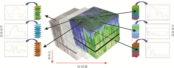
图 1 谱遥感地物识别基础
Fig. 1. Schematic for the recognition of ground objects based on spectral remote sensing
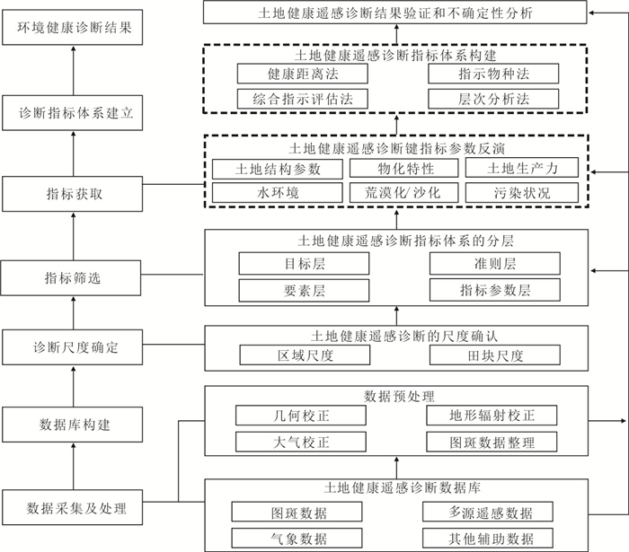
图 3 土地健康遥感诊断指标体系构建技术路线
Fig. 3. Technology roadmap for the establishment of healthy land indexes based on spectral sensing
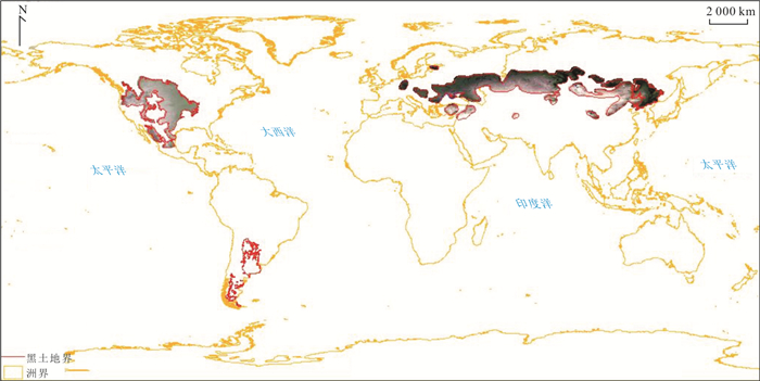
图 4 北纬46度带黑土区遥感影像
Fig. 4. Remote sensing image for the black soil area at the zone of 46 degree north latitude
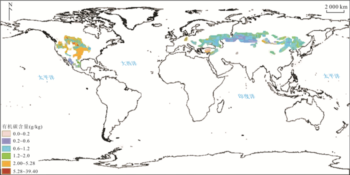
图 5 北纬46度带黑土区有机碳分布
Fig. 5. Distribution for the organic carbon of the black soil at the zone of 46 degree north latitude
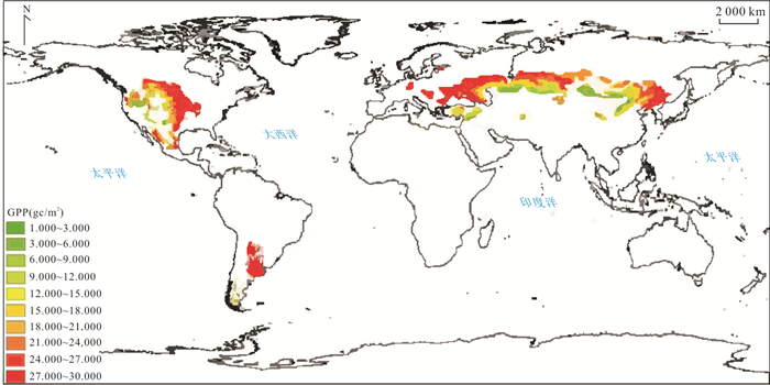
图 6 北纬46度带黑土区总初级生产力分布
Fig. 6. Distribution for the gross primary productivity (GPP) of the black soil area at the zone of 46 degree north latitude
表 1 国际上部分已发射与即将发射的高光谱卫星及其载荷指标
Table 1. Load indexes for the international hyperspectral satellite to be launched and launched
载荷/卫星 国别/地区 发射年份 谱段范围(nm) 谱段数 光谱分辨率(nm) 空间分辨率(m) 成像幅宽(km) AHSI/GF5 中国 2018 400~2 500 330 VNIR:5 SWIR:10 30 60 ZH1-OHS 中国 2018 400~1 000 256个谱段中任选32 2.5 10 150 AHSI/ZY1-02D 中国 2019 400~2 500 166 VNIR:10 SWIR:20 30 60 PRISMA 意大利 2019 400~2 500 238 < 12 5/30 30 EnMAP 德国 待发射 420~2 450 > 240 6.5~10.0 30 30 GISAT 印度 待发射 900~2 500 150 < 10 500 / ALOS-3 日本 待发射 450~2 500 189 10.0~12.5 5/30 90 MTG-S1 欧盟 待发射 300~775 590 0.5/0.12 / 8 HyspIRI 美国 待发射 400~2 500 400~12 000 220 8 10 60 150 SHALOM 美国 待发射 400~2 500 275 10 10 30 AHSI/GF5-02 中国 待发射 400~2 500 330 VNIR:5 SWIR:10 30 60 AHSI/ZY1-02E 中国 待发射 400~2 500 166 VNIR:10 SWIR:20 30 60  下载: 导出CSV
表 2 典型机载成像仪的技术参数
Table 2. Parameters of typical airborne imaging instruments
传感器 产地 启用年份 谱段范围(nm) 光谱分辨率(nm) 空间分辨率(m) 通道数 幅宽(m) AIS-1 美国 1983 1.2~2.4 9.3 3.8 128 125 AIS-2 美国 1986 0.8~2.4 10.6 4.1 128 260 CASI/SASI 加拿大 1988 0.38~2.45 VNIR:5 SWIR:6.25 1 133 150 AVIRIS 美国 1989 0.4~2.5 10 20 224 11 000 TRWIS-3 美国 1990 0.4~2.5 VNIR:5 SWIR:6.25 1.8 384 460 ROSIS 德国 1991 0.43~0.85 4 2.5 256 1 000 IMS 法国 1991 0.115~3.000 VNIR:12.5 SWIR:25.0 - 64 - OMIS 中国 1991 0.46~12.50 VNIR:10 SWIR:40 6 128 3 000 ASAS 美国 1992 0.40~1.06 11.5 - 62 - PHI 中国 1996 0.40~0.85 5 2 244 1 000 HYMAP 澳大利亚 1997 0.45~2.50 VNIR:15 SWIR:15 4.5 128 3 460 GER DAIS 美国 1998 0.4~2.5 12 10 211 4 000 WPHI 中国 2000 0.4~2.5 VNIR:5 SWIR:6.25 4 - 4 000 SIVNIR/SWIR 挪威 2003 0.4~2.5 5 1 160 400 AHI 美国 2004 7.0~11.5 18 - 256 -
下载: 导出CSV
表 3 常用地面光谱传感器参数
Table 3. Parameters of main ground spectral sensors
传感器 国别 波长范围(nm) 波段数 光谱分辨率(nm) ASD FieldSpec 3 美国 350~1 050,1 000~2 500 2 150 1.4,2 ASD pro FR 美国 350~1 050,1 000~2 500 2 150 1.4,2 FTIR 德国 2500~25 000 9 000 2.5 Headwall HS-VNIR 美国 400~1 000 753 0.8 Perkin Elmer Lambda 900 美国 320~2 480 1 081 2 VIS-NIR 美国 920~1 718 128 6.3 Spectralevolution Unispec-SC 英国 310~1 130 82 10 MATRIX-1 德国 781~2 779 800 2.5 SVC-GER 1500 美国 300~1 100 250 3.2 Cary 5000 美国 350~2 500 2 150 1 Fiber Optic Center FTS 175 美国 500~2 500 400 5 Nicolet 380 美国 500~2 500 400 5 SVC HR-768 美国 350~2 500 1 024 variable
下载: 导出CSV
-
Birkett, S., 2019. Sixth Global Environment Outlook GEO-6. United Nations Environment Programme, Cambridge. Bruzzone, L., Casadio, S., Cossu, R., et al., 2003. A System for Monitoring NO2 Emissions from Biomass Burning by Using GOME and ATSR-2 Data. International Journal of Remote Sensing, 24(8): 1709-1721. https://doi.org/10.1080/01431160210144714 Cao, C. X., Chen, W., Huang, X. Y., et al., 2017. Index System for Diagnosis of Environmental Health by Remote Sensing. Science Press, Beijing (in Chinese). Che, Y.F., Zhao, Y.J., Ye, F.W., 2017. Extraction and Analysis of Hyperspectral Remote Sensing Alteration Mineral Based on Spectral Characteristic Parameters. Geological Review, 63(S1): 197-198 (in Chinese with English abstract). Chikhaoui, M., Bonn, F., Bokoye, A. I., et al., 2005. A Spectral Index for Land Degradation Mapping Using ASTER Data: Application to a Semi-Arid Mediterranean Catchment. International Journal of Applied Earth Observation and Geoinformation, 7(2): 140-153. https://doi.org/10.1016/j.jag.2005.01.002 Clark, R. N., Swayze, G. A., Livo, K. E., et al., 2003. Imaging Spectroscopy: Earth and Planetary Remote Sensing with the USGS Tetracorder and Expert Systems. Journal of Geophysical Research: Planets, 108(E12): 5131. https://doi.org/10.1029/2002je001847 Corradini, S., Pugnaghi, S., Teggi, S., et al., 2003. Will ASTER See the Etna SO2 Plume?. International Journal of Remote Sensing, 24(6): 1207-1218. https://doi.org/10.1080/01431160210153084 Duro, D. C., Coops, N. C., Wulder, M. A., et al., 2007. Development of a Large Area Biodiversity Monitoring System Driven by Remote Sensing. Progress in Physical Geography: Earth and Environment, 31(3): 235-260. https://doi.org/10.1177/0309133307079054 Feng, Y. L., Yang, J. J., Wang, X. G., 2018. Research Progress of Quantitative Evaluation on Water and Soil Loss by Remote Sensing Based on Gis. Geology and Resources, 27(3): 279-283 (in Chinese with English abstract). Goetz, A. F. H., Vane, G., Solomon, J. E., et al., 1985. Imaging Spectrometry for Earth Remote Sensing. Science, 228(4704): 1147-1153. https://doi.org/10.1126/science.228.4704.1147 He, C., Feng, Z. K., Yuan, J. J., et al., 2012. Advances in the Research on Hyperspectral Remote Sensing in Biodiversity and Conservation. Spectroscopy and Spectral Analysis, 32(6): 1628-1632 (in Chinese with English abstract). http://www.ncbi.nlm.nih.gov/pubmed/22870654 Hou, Z. Q., 2020. Promote Basic Research with Strategic Thinking. China Natural Resources News, Beijing (in Chinese). Hunt, G. R., 1977. Spectral Signatures of Particulate Minerals in the Visible and near Infrared. Geophysics, 42(3): 501-513. https://doi.org/10.1190/1.1440721 Ji, H. Y., Zhao, B. Y., 2008. Summarization of Remote Sensing Technology on Environmental Monitoring. Environmental Science Survey, 27(2): 21-24 (in Chinese with English abstract). Li, S. J., Wang, X. J., 2002. The Spectral Features Analysis and Quantitative Remote Sensing Advances of Inland Water Quality Parameters. Geography and Territorial Research, 18(2): 26-30 (in Chinese with English abstract). http://search.cnki.net/down/default.aspx?filename=DLGT200202007&dbcode=CJFD&year=2002&dflag=pdfdown Li, Z. Z., 2020. Selenium-Enriched Soil Mapping Using Airborne SASI Images. Geoderma, 363: 114133. https://doi.org/10.1016/j.geoderma.2019.114133 Li, Z. Z., Wang, D. M., Liu, D. C., et al., 2015. Hyperspectral Remote Sensing Technology and Its Progress in Resources Exploration. Earth Science, 40(8): 1287-1294 (in Chinese with English abstract). Li, Z. Z., Yang, R. H., Dang, F. X., et al., 2009. The Hyperspectral Remote Sensing Technology and Its Application. Geological Bulletin of China, 28(Z1): 270-277 (in Chinese with English abstract). Lin, H., 2011. Research on Forest Tree Species with the Hyperspectral Remote Sensing Technology. China Forestry Publishing House, Beijing (in Chinese). Lu, D. H., Zhao, Y. J., Zhang, D. H., et al., 2017. Analysis of the Role of Multi-Source Remote Sensing Data in Geological Environment Stability Assessment. Geological Review, 63(S1): 399-400 (in Chinese with English abstract). Marco, L., 2018. Living Planet Report. World Wildlife Fund, Washington, D.C. . Pu, R. L., Gong, P., 2000. Hyperspectral Remote Sensing and Its Application. Higher Education Press, Beijing (in Chinese). Qin, K., Chen, J. P., Zhao, Y. J., et al., 2015. Study on Lithological Identification Method Based on Airborne Hyper-Spectral Data. Mineral Exploration, 6(5): 594-600 (in Chinese with English abstract). http://en.cnki.com.cn/Article_en/CJFDTOTAL-YSJS201505014.htm Rencz, A. N., 1999. Remote Sensing for the Earth Sciences: Manual of Remote Sensing (3rd Edition). John Wiley and Sons, Toronto. Shu, X. Z., Yin, Q., Kuang, D. B., 2000. Relationship between Algal Chlorophyll Concentration and Spectral Reflectance of Inland Water. Journal of Remote Sensing, 4(1): 41-45 (in Chinese with English abstract). Tong, Q. X., 2008. Development of Hyperspectral Remote Sensing in China. China Survey and Mapping News, Beijing (in Chinese) Wang, J. N., Li, Z. Z., Zhang, L. F., et al., 2012. "Spectral Crust" Project: Research on New Mineral Exploration Technology. Journal of Geo-Information Science, 14(3): 344-351 (in Chinese with English abstract). doi: 10.3724/SP.J.1047.2012.00344 Wang, J. N., Zhang, B., Liu, J. G., et al., 1999. Hyperspectral Data Mining: Toward Target Recognition and Classification. Journal of Image and Graphics, 4(11): 957-964 (in Chinese with English abstract) Wang, Y. X., 2020. Innovative Development of Medical Geology: A One Health Perspective. Earth Science, 45(4): 1093-1102 (in Chinese with English abstract). Wu, C. S., Xiang, Y. Q., Zheng, L. F., et al., 2000. Estimating Chlorophyll Density of Crop Canopies by Using Hyperspectral Data. Journal of Remote Sensing, 4(3): 228-232 (in Chinese with English abstract). Wu, J., Peng, D. L., 2011. Advances in Researches on Hyperspectral Remote Sensing Forestry Information-Extracting Technology. Spectroscopy and Spectral Analysis, 31(9): 2305-2312 (in Chinese with English abstract). http://www.ncbi.nlm.nih.gov/pubmed/22097816/ Yang, J. J., Bai, L., Wu, S., 2019. Study on the Erosion in Typical Black Soil Areas of Heilongjiang Province by Remote Sensing Monitoring Technology. Geology and Resources, 28(2): 193-199 (in Chinese with English abstract). http://en.cnki.com.cn/Article_en/CJFDTotal-GJSD201902013.htm Ye, F. W., Liu, D. C., Zhao, Y. J., 2011. Airborne Hyper-Spectral Survey System CASI/SASI and Its Preliminary Application in Uranium Exploration. World Nuclear Geoscience, 28(4): 231-236 (in Chinese with English abstract). http://en.cnki.com.cn/Article_en/CJFDTOTAL-GWYD201104010.htm Zhang, C. F., Hao, L. N., Wang, S. J., et al., 2020. Geological Units Classification with Texture-Spectral Synergy of Multi-Sourced Remote Sensing Images. Earth Science, 45(5): 1844-1854 (in Chinese with English abstract). Zhang, D. H., Zhao, Y. J., Qin, K., 2018a. Design and Construction of the Typical Ground Target Spectral Information System. Remote Sensing for Land & Resources, 30(4): 206-211 (in Chinese with English abstract). http://www.zhangqiaokeyan.com/academic-journal-cn_remote-sensing-land-resources_thesis/0201270245203.html Zhang, D. H., Zhao, Y. J., Qin, K., et al., 2018b. A Review of Hyperspectral Multivariate Information Extraction Models for Soils. Soil and Fertilizer Sciences in China, (2): 22-28 (in Chinese with English abstract). http://www.zhangqiaokeyan.com/academic-journal-cn_soil-fertilizer-sciences-china_thesis/0201257078546.html Zhao, D. Z., 1999. Research on Monitoring System of Marine Environmental Pollution Based on Satellite Remote Sensing Technique. Remote Sensing Information, 14(2): 22-25 (in Chinese with English abstract). Zheng, L. F., Wang, J. N., 1992. A Study on Imaging Spectrometry and Its Extraction of Image Spectral Information. Remote Sensing of Environmental China, 7(1): 49-58 (in Chinese with English abstract). http://en.cnki.com.cn/Article_en/CJFDTOTAL-YGXB199201006.htm Zhong, Y., 2016. Remote Sensing Estimation of Heavy Metal Cd and Pb in Cultivated Soil Based on HSI Hyperspectral Data (Dissertation). Sichuan Agriculture University, Ya'an (in Chinese with English abstract). 曹春香, 陈伟, 黄晓勇, 等, 2017. 环境健康遥感诊断指标体系. 北京: 科学出版社. 车永飞, 赵英俊, 叶发旺, 2017. 基于光谱特征参量的高光谱遥感蚀变矿物提取与分析. 地质论评, 63(S1): 197-198. https://www.cnki.com.cn/Article/CJFDTOTAL-DZLP2017S1096.htm 冯雨林, 杨佳佳, 王晓光, 2018. 基于GIS技术的水土流失遥感定量评价研究进展. 地质与资源, 27(3): 279-283. doi: 10.3969/j.issn.1671-1947.2018.03.011 何诚, 冯仲科, 袁进军, 等, 2012. 高光谱遥感技术在生物多样性保护中的应用研究进展. 光谱学与光谱分析, 32(6): 1628-1632. doi: 10.3964/j.issn.1000-0593(2012)06-1628-05 侯增谦, 2020. 用战略思维推动基础研究. 北京: 中国自然资源报. 季惠颖, 赵碧云, 2008. 遥感技术在环境监测中的应用综述. 环境科学导刊, 27(2): 21-24 doi: 10.3969/j.issn.1673-9655.2008.02.006 李素菊, 王学军, 2002. 内陆水体水质参数光谱特征与定量遥感. 地理学与国土研究, 18(2): 26-30. doi: 10.3969/j.issn.1672-0504.2002.02.008 李志忠, 汪大明, 刘德长, 等, 2015. 高光谱遥感技术及资源勘查应用进展. 地球科学, 40(8): 1287-1294. doi: 10.3799/dqkx.2015.108 李志忠, 杨日红, 党福星, 等, 2009. 高光谱遥感卫星技术及其地质应用. 地质通报, 28(Z1): 270-277. https://www.cnki.com.cn/Article/CJFDTOTAL-ZQYD2009Z1021.htm 林辉, 2011. 森林树种高光谱遥感研究. 北京: 中国林业出版社. 陆冬华, 赵英俊, 张东辉, 等, 2017. 多元遥感数据在地质环境稳定性评价的作用分析. 地质论评, 63(S1): 399-400. https://www.cnki.com.cn/Article/CJFDTOTAL-DZLP2017S1192.htm 浦瑞良, 宫鹏, 2000. 高光谱遥感及其应用. 北京: 高等教育出版社. 秦凯, 陈建平, 赵英俊, 等, 2015. 基于航空高光谱遥感岩性识别技术研究. 矿产勘查, 6(5): 594-600. doi: 10.3969/j.issn.1674-7801.2015.05.014 疏小舟, 尹球, 匡定波, 2000. 内陆水体藻类叶绿素浓度与反射光谱特征的关系. 遥感学报, 4(1): 41-45. https://www.cnki.com.cn/Article/CJFDTOTAL-YGXB200001007.htm 童庆禧, 2008. 我国高光谱遥感的发展. 北京: 中国测绘报. 王晋年, 李志忠, 张立福, 等, 2012. "光谱地壳"计划: 探索新一代矿产勘查技术. 地球信息科学学报, 14(3): 344-351. https://www.cnki.com.cn/Article/CJFDTOTAL-DQXX201203010.htm 王晋年, 张兵, 刘建贵, 等, 1999. 以地物识别和分类为目标的高光谱数据挖掘. 中国图象图形学报, 4(11): 957-964. https://www.cnki.com.cn/Article/CJFDTOTAL-ZGTB199911012.htm 王焰新, 2020. "同一健康"视角下医学地质学的创新发展. 地球科学, 45(4): 1093-1102. doi: 10.3799/dqkx.2020.060 吴长山, 项月琴, 郑兰芬, 等, 2000. 利用高光谱数据对作物群体叶绿素密度估算的研究. 遥感学报, 4(3): 228-232. https://www.cnki.com.cn/Article/CJFDTOTAL-YGXB200003012.htm 吴见, 彭道黎, 2011. 高光谱遥感林业信息提取技术研究进展. 光谱学与光谱分析, 31(9): 2305-2312. https://www.cnki.com.cn/Article/CJFDTOTAL-GUAN201109000.htm 杨佳佳, 白磊, 吴嵩, 2019. 黑龙江典型黑土区土壤侵蚀遥感监测技术研究. 地质与资源, 28(2): 193-199. doi: 10.3969/j.issn.1671-1947.2019.02.012 叶发旺, 刘德长, 赵英俊, 2011. CASI/SASI航空高光谱遥感测量系统及其在铀矿勘查中的初步应用. 世界核地质科学, 28(4): 231-236. doi: 10.3969/j.issn.1672-0636.2011.04.008 张翠芬, 郝利娜, 王少军, 等, 2020. 多源遥感数据图谱协同岩石单元分类方法. 地球科学, 45(5): 1844-1854. doi: 10.3799/dqkx.2019.168 张东辉, 赵英俊, 秦凯, 2018a. 典型目标地面光谱信息系统设计与实现. 国土资源遥感, 30(4): 206-211. https://www.cnki.com.cn/Article/CJFDTOTAL-GTYG201804031.htm 张东辉, 赵英俊, 秦凯, 等, 2018b. 高光谱土壤多元信息提取模型综述. 中国土壤与肥料, (2): 22-28. https://www.cnki.com.cn/Article/CJFDTOTAL-TRFL201802004.htm 赵冬至, 1999. 海洋环境污染与灾害卫星遥感业务化监测系统研究. 遥感信息, 14(2): 22-25. doi: 10.3969/j.issn.1000-3177.1999.02.009 郑兰芬, 王晋年, 1992. 成像光谱遥感技术及其图像光谱信息提取的分析研究. 环境遥感, 7(1): 49-58. https://www.cnki.com.cn/Article/CJFDTOTAL-YGXB199201006.htm 钟燕, 2016. 基于HSI高光谱数据的耕地土壤重金属镉、铅含量遥感反演(硕士学位论文). 雅安: 四川农业大学. -

 点击查看大图
计量
- 文章访问数: 2210
- HTML全文浏览量: 1057
- PDF下载量: 81
- 被引次数: 0
