


Error Correction in Geological Model Based on Stratigraphic Interdependency
-
摘要: 在地质勘探中,多数钻孔存在深部地层底板未采样的情况,不完整的采样信息限制了地质模型的准确性.为了提高模型准确性,提出了一种基于地层相关结构约束的地层面模型修正方法.由于地层的形成机制及后期构造运动,相邻地层的形态具有相似性.基于此,利用Copula函数对相邻地层面的相关结构进行建模,构建相邻地层面的联合分布模型和待更新地层面的似然函数.在贝叶斯框架中,利用似然函数对待修正的模型进行贝叶斯更新,得到地层面的后验分布,计算地层面的条件期望作为模型修正值.利用该方法,对北海海岸带地区的钻孔数据和地层面模型进行了实验.实验结果表明,模型修正后,地层面模型的误差降低,所提方法可以提高地质模型准确性.Abstract: In geological exploration, the bottom interface of deep stratum is not sampled in most boreholes, and incorrect sample information limits the accuracy of geological models. In order to improve the accuracy of geological model, we proposes a method to correct geological model based on stratigraphic interdependency. Due to the formation mechanism of the strata, the morphology of the adjacent strata is similar. Based on this character, the Copula function is used to model the dependence structure of adjacent strata, and the joint distribution model of adjacent strata and the likelihood function of the stratum to be corrected are constructed. In the Bayesian framework, the established interface model is taken as the prior model, and the likelihood function is used to update the prior model to obtain the posterior distribution. In the end, the condition expectation of the interface is calculated as the posterior model. The proposed approach is illustrated through a case study of the geological interface model of the coastal zone near Beihai. The results show that the error of the geological interface model is reduced after model correction.
-
Key words:
- geologic models /
- error correction /
- stratigraphic interdependency /
- Bayes /
- Copula
-
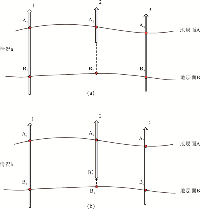
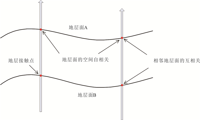
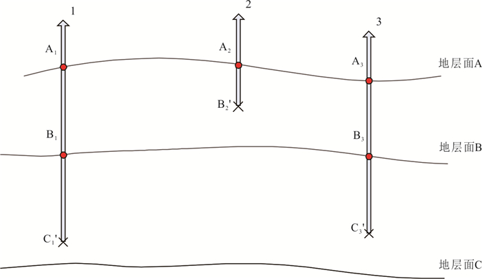
图 3 待修正地层面数据的两种情况
Fig. 3. Two different cases of interface B recorded in No. 2 borehole.
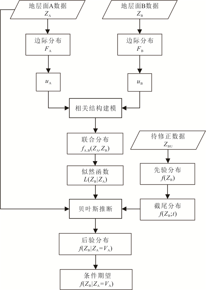
图 5 基于双地层Copula的模型修正流程图
Fig. 5. Model correction flowchart based on Copula of two adjacent strata
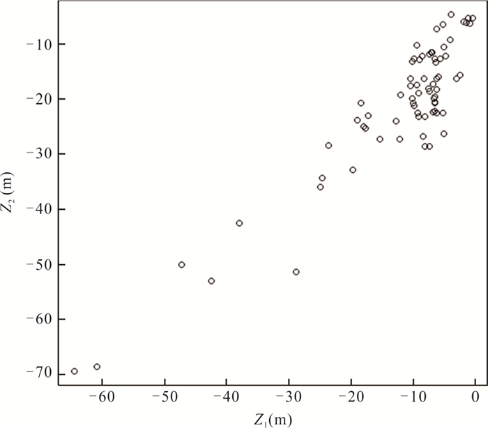
图 7 ⑤-2和⑥-1地层面高程值的分布图
Fig. 7. Scatter diagrams of the elevation of interface ⑤-2 and ⑥-1
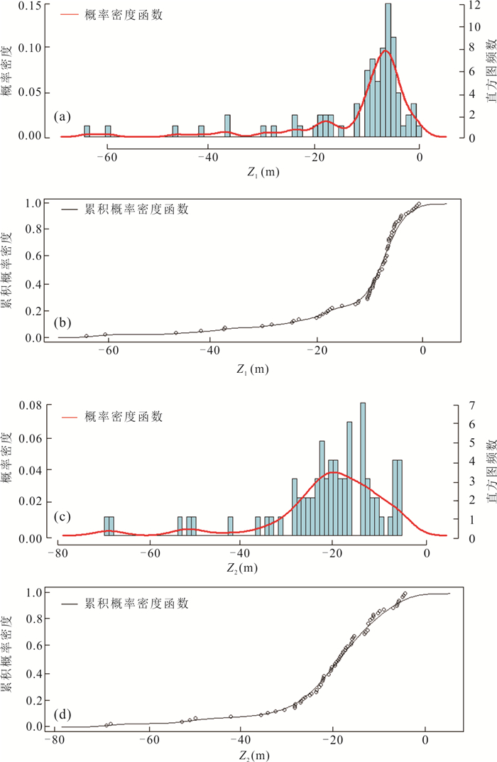
图 8 ⑤-2和⑥-1地层面高程统计直方图和边际概率分布
Fig. 8. Histogram and marginal probability distribution of elevation of interface ⑤-2 and ⑥-1
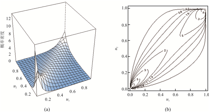
图 9 ⑤-2和⑥-1地层面高程Copula密度图
Fig. 9. Copula densities of interface ⑤-2 (u1) and interface ⑥-1 (u2) in 3D and contour map
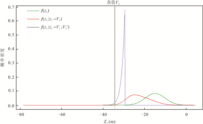
图 10 #8钻孔位置上的⑥-1地层面贝叶斯更新
Fig. 10. Bayesian updating of probability distributions of interface ⑥-1 at borehole #8
图 11 #8钻孔位置上的⑥-1地层面高程似然函数$ f\left({z}_{1}={V}_{1}|{z}_{2}\right) $
Fig. 11. Likelihood function $ f\left({z}_{1}={V}_{1}|{z}_{2}\right) $ of interface ⑥-1 at borehole #8
表 1 验证位置上修正前后的模型值与样本值的比较(m)
Table 1. Model values (unit: m) before and after correction comparing with observed values in validation boreholes
钻孔位置 样本值 不准确样本值 IDW模型值 未截尾修正值 截尾修正值 #V1 -51.50 -40.15 -24.85 -36.05 -42.61 #V2 -68.60 -64.60 -21.18 -40.78 -65.59 #V3 -27.56 -19.91 -17.97 -28.35 -30.21 #V4 -19.82 -13.23 -20.74 -19.79 -19.81 #V5 -26.99 -17.76 -19.24 -19.95 -24.92 #V6 -21.48 -15.73 -16.82 -21.98 -24.64 #V7 -50.20 -48.65 -23.93 -38.64 -52.34 #V8 -34.60 -29.60 -15.08 -22.61 -31.41 #V9 -69.40 -66.80 -23.34 -38.48 -69.00 #V10 -18.50 -12.45 -20.76 -12.53 -19.62 #V11 -13.72 -10.12 -25.91 -20.88 -21.54 #V12 -5.60 -3.15 -6.81 -5.92 -6.08 #V13 -6.50 -4.10 -6.17 -5.09 -6.09 #V14 -5.60 -3.45 -9.15 -8.43 -8.44 #V15 -12.50 -10.6 -5.78 -5.96 -11.35 #V16 -10.80 -8.05 -13.68 -12.61 -12.97 #V17 -13.10 -11.10 -12.00 -12.87 -14.08 #V18 -13.50 -11.90 -13.92 -16.24 -17.32 #V19 -13.00 -9.85 -15.42 -15.31 -15.31 #V20 -26.50 -15.85 -20.22 -19.72 -19.73 … … … … … …  下载: 导出CSV
表 2 修正前后模型误差统计(m)
Table 2. Cross-validation errors (unit: m)
地层面模型 MAE ME RMSE IDW 8.18 2.25 12.60 未截尾修正值 6.77 0.74 9.59 截尾修正值 4.77 -2.34 6.59
下载: 导出CSV
表 3 未钻透位置上不准确测量值与修正后模型值的比较(m)
Table 3. Model values before and after correction comparing with biased observed values in inaccurate boreholes(m)
钻孔位置 不准确样本值 IDW模型值 截尾修正值 #U1 -20.00 -18.24 -20.63 #U2 -20.00 -19.92 -21.25 #U3 -5.60 -20.77 -20.35 #U4 -15.00 -21.08 -20.55 #U5 -20.00 -20.95 -21.41 #U6 -50.50 -26.83 -54.81 #U7 -50.20 -41.62 -53.20
下载: 导出CSV
-
Abrahamsen, P., Omre, H., 1994. Random Functions and Geological Subsurfaces. Ecmor Ⅳ-European Conference on the Mathematics of Oil Recovery, Røros, Norway, 21. https://doi.org/10.3997/2214-4609.201411142 Autin, J., Scheck-Wenderoth, M., Götze, H. J., et al., 2016. Deep Structure of the Argentine Margin Inferred from 3D Gravity and Temperature Modelling, Colorado Basin. Tectonophysics, 676(47): 198-210. https://doi.org/10.1016/j.tecto.2015.11.023 Bárdossy, A., 2006. Copula-Based Geostatistical Models for Groundwater Quality Parameters. Water Resources Research, 42(11). https://doi.org/10.1029/2005wr004754 Bárdossy, A., Li, J., 2008. Geostatistical Interpolation Using Copulas. Water Resources Research, 44(7). https://doi.org/10.1029/2007wr006115 Calcagno, P., Chiles, J. P., Courrioux, G., at al., 2008. Geological Modelling from Field Data and Geological Knowledge: Part Ⅰ. Modelling Method Coupling 3D Potential-Field Interpolation and Geological Rules. Physics of the Earth and Planetary Interiors, 171 (1-4): 147-157. https://doi.org/10.1016/j.pepi.2008.06.013 Caumon, G., Journel, A. G., 2004. Early Uncertainty Assessment: Application to A Hydrocarbon Reservoir Appraisal. Geostatistics Banff 2004, Springer, Dordrecht, 551-557. https://doi.org/10.1007/978-1-4020-3610-1_56 Daly, C., 2006. Guidelines for Assessing the Suitability of Spatial Climate Data Sets. International Journal of Climatology, 26(6): 707-721. https://doi.org/10.1002/joc.1322 de Kemp, E. A., Sprague, K. B., 2003. Interpretive Tools for 3-D Structural Geological Modeling Part Ⅰ: Bxezier-Based Curves, Ribbons and Grip Frames. Geoinformatica, 7 (1): 55-71. https://doi.org/10.1023/a:1022822227691 De la Varga, M., Schaaf, A., Wellmann J. F., 2018. GemPy 1.0: Open-Source Stochastic Geological Modeling and Inversion. Geoscientific Model Development Discussions, 1-50. https://doi.org/10.5194/gmd-12-1-2019 De Paor, D. G., 1996. Bxezier Curves and Geological Design. In: De Paor, D. G., ed., Computer Methods in the Geosciences. Pergamon, 389-417. https://doi.org/10.1016/s1874-561x(96)80031-9 Fremming, N. P., 2002. 3D Geological Model Construction Using a 3D Grid. ECMOR Ⅷ-8th European Conference on the Mathematics of Oil Recovery. https://doi.org/10.3997/2214-4609.201405917 Gradmann, S., Ebbing, J., Fullea, J., 2013. Integrated Geophysical Modelling of a Lateral Transition Zone in the Lithospheric Mantle under Norway and Sweden. Geophysical Journal International, 194 (3): 1358-1373. https://doi.org/10.1093/gji/ggt213 Haase, C., Ebbing, J., Funck, T., 2017. A 3D Regional Crustal Model of the NE Atlantic Based on Seismic and Gravity Data. Geological Society, London, Special Publications, 447 (1): 233-247. https://doi.org/10.1144/sp447.8 Hou, Z., Wang, T. Y., Yu, C. C., et al., 2018. Study of 3d Geological Modeling Based on Aeromagnetic Data. Advances in Earth Science, 33(3): 257-269 (in Chinese with English abstract). Kessler, H., Mathers, S., Sobisch, H. G., 2009. The Capture and Dissemination of Integrated 3D Geospatial Knowledge at the British Geological Survey Using GSI3D Software and Methodology. Computers & Geosciences, 35 (6): 1311-1321. https://doi.org/10.1016/j.cageo.2008.04.005 Lemon, A. M., Jones, N. L., 2003. Building Solid Models from Boreholes and User-Defined Cross-Sections. Computers & Geosciences, 29(5): 547-555. https://doi.org/10.1016/s0098-3004(03)00051-7 Liu, Z. F., Wei, Z. H., Huang, X. J., et al., 2012. Research on Dynamic Update Method of 3d Geological Model: A Case Study of Water Resources and Hydropower Projects. China Rural Water and Hydropower, 11: 93-96 (in Chinese with English abstract). Lyu, Y. H., Du, Y., Zou, C. Y., 2007. Improved Numerical Simulation Method of Complex Fault Block Oil Reservoir. Fault-Block Oil & Gas Field, 14(6): 21-22, 94 (in Chinese with English abstract). Ming, J., Pan, M., Qu, H. G., et al., 2010. GSIS: A 3D Geological Multi-Body Modeling System from Netty Cross-Sections with Topology. Computers & Geosciences, 36(6): 756-767. https://doi.org/10.1016/j.cageo.2009.11.003 Nelsen, R. B., 2007. An Introduction to Copulas. Springer, New York. Perrin, M., Rainaud, J. F., 2013. Shared Earth Modeling: Knowledge Driven Solutions for Building and Managing Subsurface 3D Geological Models, Editions Technip. Sadegh, M., Ragno, E., Aghakouchak, A., 2017. Multivariate Copula Analysis Toolbox (MvCAT): Describing Dependence and Underlying Uncertainty Using a Bayesian Framework. Water Resources Research, 53. https://doi.org/10.1002/2016WR020242. Sklar, A, 1959. Fonctions de Repartition An Dimensions et Leurs Marges. Publications de l'Insitut de Statistique de Paris, 229-231 Sprague, K. B., de Kemp, E. A., 2005. Interpretive Tools for 3-D Structural Geological Modelling Part Ⅱ: Surface Design from Sparse Spatial Data. GeoInformatica, 9(1): 5-32. https://doi.org/10.1007/s10707-004-5620-8 Tacher, L., Pomian-Srzednicki, I., Parriaux, A., 2006. Geological Uncertainties Associated with 3-D Subsurface Models. Computers & Geosciences, 32(2): 212-221. https://doi.org/10.1016/j.cageo.2005.06.010 Tan, F., Wang, J., Jiao, Y.Y., et al., 2021. Current Situation and Development of Urban Underground Space Suitability Evaluation. Earth Science, 46(5): 1896-1908 (in Chinese with English abstract). Tearpock, D. J., Bischke, R. E., 1991. Applied Subsurface Geological Mapping. Prentice Hall. Tobler, W. R., 1970. A Computer Movie Simulating Urban Growth in the Detroit Region. Economic Geography, 46: 234. https://doi.org/10.2307/143141 Wellmann, J. F., de la Varga, M., Murdie, R. E., et al., 2017. Uncertainty Estimation for a Geological Model of the Sandstone Greenstone Belt, Western Australia: Insights from Integrated Geological and Geophysical Inversion in a Bayesian Inference Framework. Geological Society, London, Special Publications, 453(1): 41-56. https://doi.org/10.1144/sp453.12 Wellmann, J. F., Caumon, G., 2018. 3-D Structural Geological Models: Concepts, Methods, and Uncertainties, Advances in Geophysics, 59: 1-121. https://doi.org/10.1016/bs.agph.2018.09.001 Winter, J. G., 1968. The Prodromus of Nicolaus Steno's Dissertation Concerning A Solid Body Enclosed by Process of Nature within A Solid, Hafner. Wolff, B, S. F., 1981. On Nonparametric Measures of Dependence for Random Variables. Annals of Statistics, 9(4): 879-885. https://doi.org/10.1214/aos/1176345528 Xie, J. R., Qiao, S. F., Qian, H., et al., 2014. The Application of Virtual Drilling Technology in the Three-Dimensional Geological Modeling of Water Resources and Hydropower. Journal of Railway Science and Engineering, (3): 123-128 (in Chinese with English abstract). Xiu, C. H., Che, D. F., Jia, G. B., 2015. A 3D Dynamic Modeling Method for Coal Seams with Complex Geological Structures. Mine Surveying, 6: 52-55 (in Chinese with English abstract). Zhang, X.L., Wu, C.L., Zhou, Q., et al., 2020. Multi-Scale 3D Modeling and Visualization of Super Large Manganese Ore Gathering Area in Guizhou China. Earth Science, 45(2): 634-644 (in Chinese with English abstract). Zhu, L. F., Wu, X. C., Pan, X., 2006. Mechan6ism and Implementation of Error Correction for 3D Strata Model. Rock and Soil Mechanics, 27(2): 268-271 (in Chinese with English abstract). Zhu, L. F., Wu, X. C., Pan, X., 2009. Theory of Accuracy Assessment and Methods for Error Correction in 3D Geological Structure Models. Earth Science Frontiers, 16(4): 363-371 (in Chinese with English abstract). Zhu, L. F., Zhang, C. J., Li, M. J., et al., 2012. Building 3D Solid Models of Sedimentary Stratigraphic Systems from Borehole Data: An Automatic Method and Case Studies. Engineering Geology, 127(8): 1-13. https://doi.org/10.1016/j.enggeo.2011.12.001 侯征, 王天意, 于长春, 等, 2018. 基于航磁数据的三维地质建模研究. 地球科学进展, 33(3): 257-269. https://www.cnki.com.cn/Article/CJFDTOTAL-DXJZ201803007.htm 刘志锋, 魏振华, 黄笑鹃, 等, 2012. 三维地质模型动态更新方法研究——以水利水电工程为例. 中国农村水利水电, 11: 93-96. https://www.cnki.com.cn/Article/CJFDTOTAL-ZNSD201211027.htm 吕迎红, 杜燕, 邹存友, 等, 2007. 复杂断块油藏地质模型修正技术探讨. 断块油气田, 14(6): 21-22, 94. https://www.cnki.com.cn/Article/CJFDTOTAL-DKYT200706006.htm 谭飞, 汪君, 焦玉勇, 等, 2021. 城市地下空间适宜性评价研究国内外现状及趋势. 地球科学, 46(5): 1896-1908. doi: 10.3799/dqkx.2020.155 谢济仁, 乔世范, 钱骅, 等, 2014. 虚拟钻孔技术在水利水电三维地质建模中的应用. 铁道科学与工程学报, 3: 123-128. https://www.cnki.com.cn/Article/CJFDTOTAL-CSTD201403022.htm 修春华, 车德福, 贾国兵, 2015. 含复杂地质构造的三维煤层动态建模方法. 矿山测量, 6: 52-55. https://www.cnki.com.cn/Article/CJFDTOTAL-KSCL201506016.htm 张夏林, 吴冲龙, 周琦, 等, 2020. 贵州超大型锰矿集区的多尺度三维地质建模. 地球科学, 45(2): 634-644. doi: 10.3799/dqkx.2018.384 朱良峰, 吴信才, 潘信, 2006. 三维地层模型误差修正机制及其实现技术. 岩土力学, 27(2): 268-271. https://www.cnki.com.cn/Article/CJFDTOTAL-YTLX200602020.htm 朱良峰, 吴信才, 潘信, 2009. 三维地质结构模型精度评估理论与误差修正方法研究. 地学前缘, 16(4): 363-371. https://www.cnki.com.cn/Article/CJFDTOTAL-DXQY200904042.htm -

 点击查看大图
计量
- 文章访问数: 1168
- HTML全文浏览量: 555
- PDF下载量: 57
- 被引次数: 0
