


Geomorphic Constraints on Listric Thrust Faulting: Implications for Active Deformation of Bayan Anticline in Youludusi Basin, East Tianshan, China
-
摘要: 将地表河流阶地变形特征与运动学模型、地貌年代相结合,可以推测出地下断层几何形态、断层变形量与变形速率.定量限定天山山间盆地不同褶皱冲断带的几何形态、运动学和变形速率是研究天山挤压应变吸收作用的关键.在天山东部的尤路都斯盆地内,开都河横穿巴音背斜构造发育并保存了较为完整的三级河流阶地.通过详细的野外考察发现,处于巴音背斜构造后翼位置的河流阶地具有宽阔、连续和逐渐倾斜的特点,符合通过翼部旋转运动而褶皱变形的铲式逆冲断层模型,其深部根植于平面断层斜坡.基于该运动学模型并结合阶地年代,得到巴音背斜构造下伏断层晚第四纪滑动速率为(0.35-0.06)~(0.35+0.16)mm/a,地壳缩短速率为(0.23-0.04)~(0.23+0.10)mm/a.对比尤路都斯盆地北部那拉提断裂的构造应变和GPS速率揭示的东天山南北向总地壳缩短速率,认为巴音背斜构造的变形作用占尤路都斯盆地总变形作用的15%~20%,进而容纳了~2%的东天山南北向地壳应变.东天山内部的山间盆地在天山变形量分配中占据重要作用.Abstract: Subsurface fault geometry and deformation rates can be estimated by combining the pattern of terrace deformation with kinematic model and geomorphic age. Quantifying the geometry, kinematics and deformation rate of the thrust-and-fold belt is the key to exploring tectonic deformation and strain distribution of the Tianshan intermontane basin. This is demonstrated by the Bayan anticline in Youlududsi basin in the eastern Chinese Tianshan. The Kaidu River, flowing through the central part of the Bayan anticline, has formed three terrace levels at tilted fold backlimbs. Based on the field geological investigation, warped and tilted terraces in the Bayan anticline are characterized by broad, continuous backlimbs and abrupt forelimbs and suggest folding through progressive limb rotation of listric thrust model. Combining with the kinematic model and geomorphic age, the slip rate and crustal shortening rate of the underlying fault in Bayan anticline is (0.35-0.06)-(0.35+0.16) mm/a and (0.23-0.04)-(0.23+0.10) mm/a, respectively. This shortening represents over 15%-20% of the total deformation in Youludusi basin and ~2% of the 8.5±0.5 mm/a total shortening rate measured from GPS velocity across the entire range in East Tianshan.Therefore, a significant fraction of the total Quaternary deformation is accommodated within the central part of the East Tianshan.
-
Key words:
- listric thrust /
- terrace /
- Bayan anticline /
- Youludusi basin /
- Tianshan /
- structural geology
-
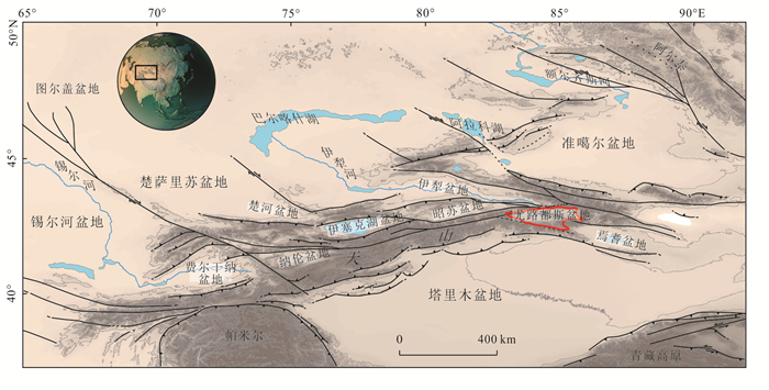
图 1 天山山脉区域构造格局
红色框线为尤路都斯盆地范围
Fig. 1. General geographic and structural framework of the Tianshan Range
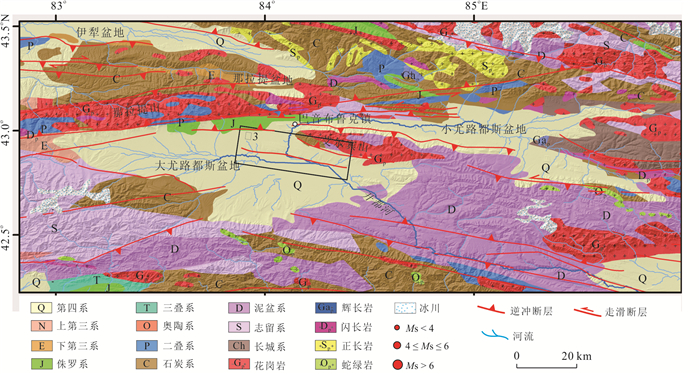
图 2 尤路都斯盆地地质构造图
地层信息根据1∶20万地质图绘制.下伏地形底图来源于12.5 m ALOS(Advanced Land Observing Satellite)数字高程模型(digital elevation model,DEM)
Fig. 2. Geological map of theYouludusi basin
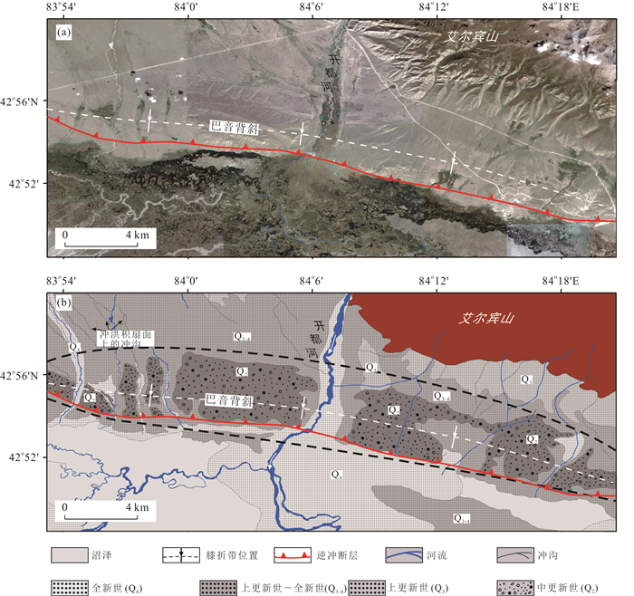
图 3 巴音背斜区域地貌解译图
a. 巴音背斜构造区Goole Earth影像;b.地貌解译地层信息来源于1∶20万地质图.图示位置见图 2
Fig. 3. Geomorphic interpretations of Bayan anticline
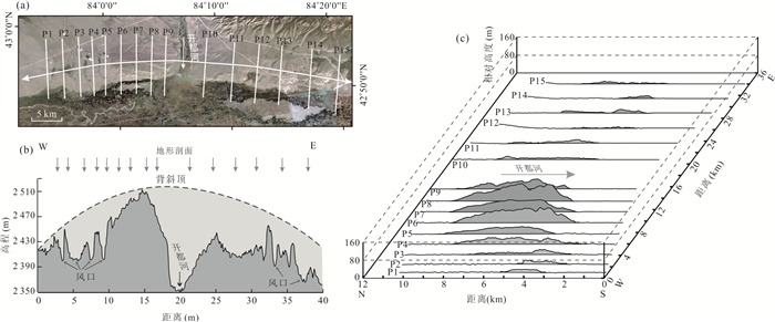
图 4 巴音背斜构造区地貌图
a. 巴音背斜构造区Goole Earth影像;b. 沿巴音背斜走向的地形剖面;c. 巴音背斜横向剖面背斜部分表面被河流/冲沟侵蚀.沿巴音背斜走向的地形剖面显示顶部隆起幅度呈弓形,且由于褶皱的生长,水流横穿背斜形成水口或风口.横穿巴音背斜的横向剖面显示背斜的扩展和延伸.背斜西部保存较为完整,东部受侵蚀严重
Fig. 4. Geomorphology of Bayan anticline
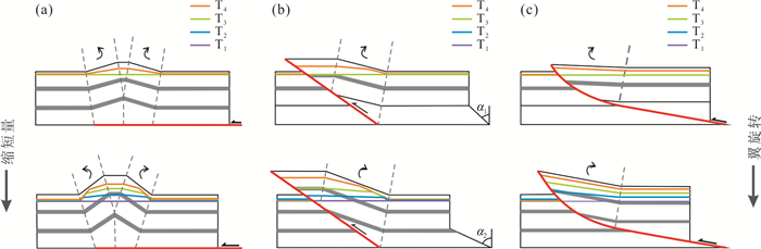
图 6 断层相关褶皱的翼旋转运动学简化模型(修改自Amos et al., 2007)
a.滑脱褶皱;b.简单剪切断弯褶皱;c.铲式断展褶皱.沿垂直于褶皱方向的横向河流形成连续的阶地面,并随地层缩短而变形
Fig. 6. Simplified kinematic models for fault-related folding involving limb rotation (modified from Amos et al., 2007)
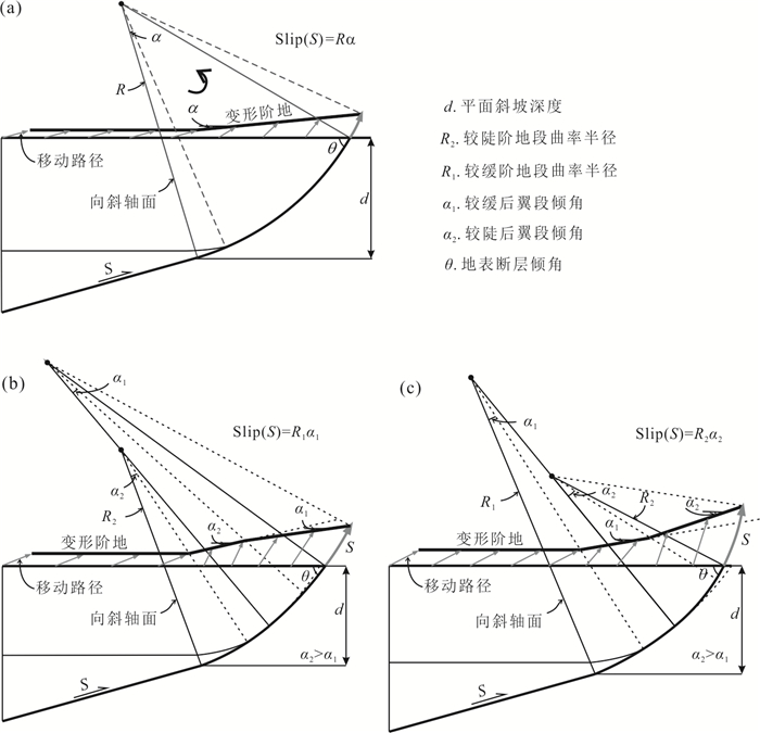
图 7 基于铲型逆冲断层的阶地变形几何学/运动学模型
a.断层曲率未变化的河流阶地变形模型(修改自Amos et al.,2007,2010);b.断层曲率半径变大的河流阶地变形模型;c.断层曲率半径变小的河流阶地变形模型.铲型逆冲断层段上的刚性旋转导致褶皱后翼倾斜.移动路径描述变形阶地随断层滑动的运动轨迹.断层逆冲过程中曲率半径增大导致褶皱后翼的变形阶地下凹.断层逆冲过程中曲率半径减小导致褶皱后翼的变形阶地上凸
Fig. 7. Geometric/kinematic model for terrace deformation over a listric thrust rooted at depth into a planarramp
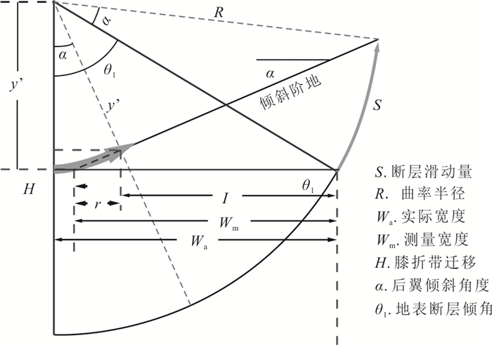
图 8 断层滑动量(S)计算图解(修改自Amos et al., 2007)
Fig. 8. Calculation diagram of fault slip momentum (S) (modified from Amos et al., 2007)
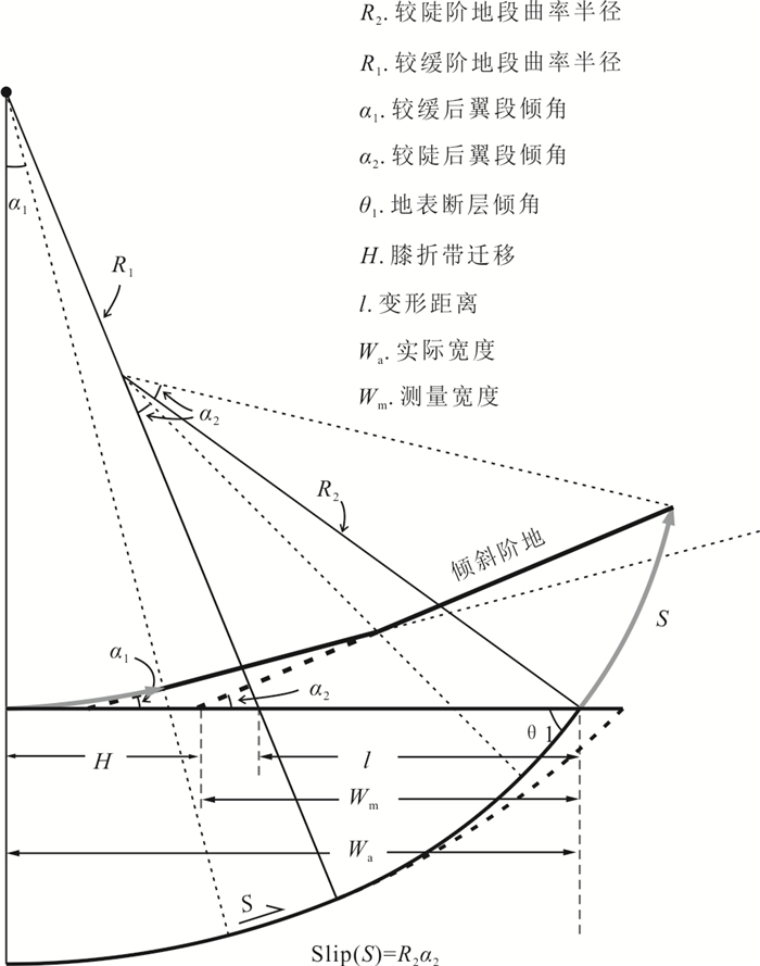
图 9 基于下凹形变形阶地的断层滑动量(S)计算图解
Fig. 9. Calculation diagram of fault slip (S) based on lower concave deformed terrace
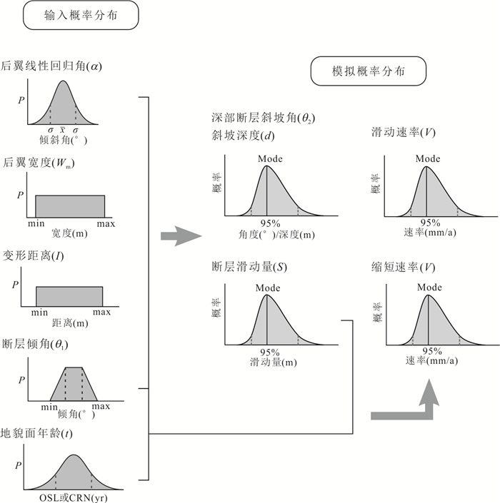
图 10 基于蒙特卡洛模拟的断层变形速率相关计算参数与输出结果示意图
后翼线性回归角(α)和地貌面年龄(t)符合正态概率密度分布;后翼宽度(Wm)和变形距离(I)符合均匀概率密度分布;断层倾角(θ)符合梯形概率密度分布
Fig. 10. Schematic illustration of inputs for Monte Carlo calculation of fault parameters and associated uncertainties (95% confidence intervals)
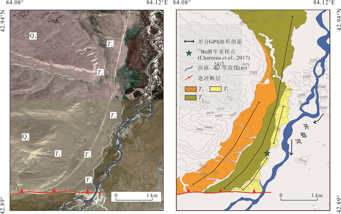
图 11 开都河穿过巴音背斜中部区域的谷歌影像(a)和地貌解译(b)
Fig. 11. Google Earth image (a) and the geomorphic interpretation (b) of the area where the Kaidu River crosses the Bayan anticline
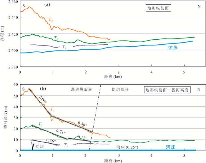
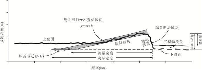
图 12 开都河阶地纵剖面
a.近似垂直于向斜轴面的原始地形纵剖面;b.去除河床高度的阶地拔河高度纵剖面.阶地纵剖面来源于野外实测差分GPS数据.河床纵剖面则是基于ALOS 12.5 m DEM数据提取.黑色直线为线性拟合线,灰色阴影部分为线性拟合的误差(95%置信区间)
Fig. 12. Kaidu River terrace profiles
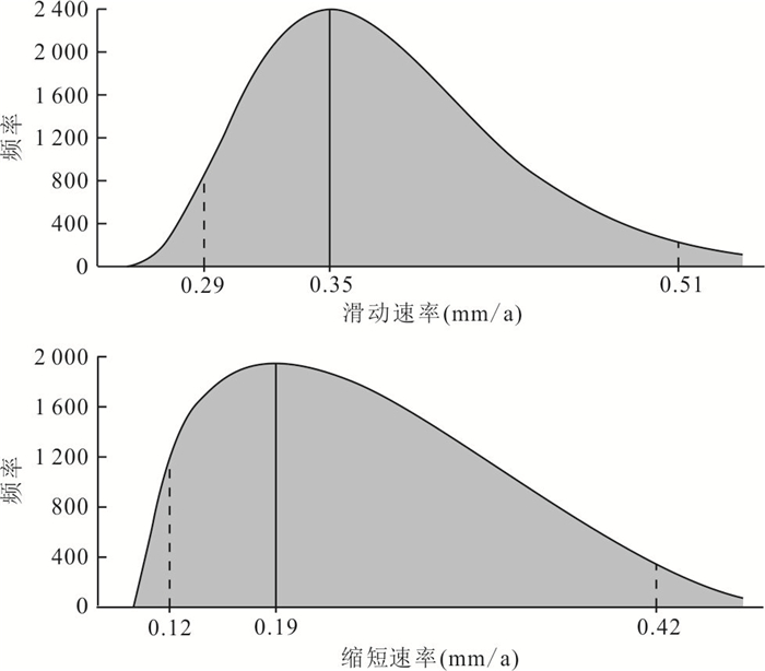
图 13 巴音背斜构造滑动速率与缩短速率
Fig. 13. Slip (up) and shortening (down) rates calculated from listric thrust model combined with geomorphic age
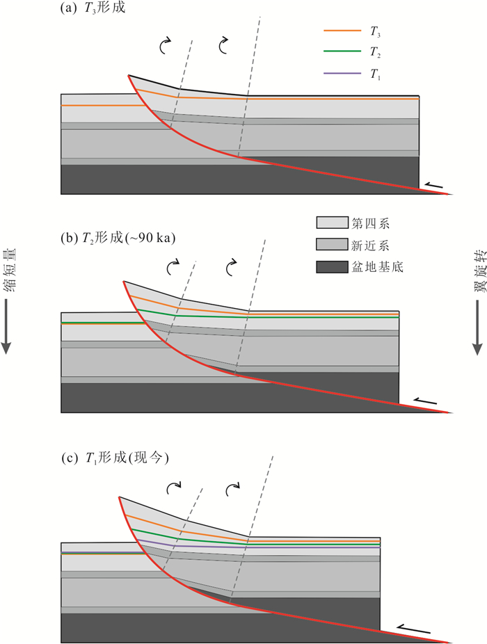
图 14 巴音背斜构造区河流阶地演化过程和断层结构
图中T3、T2和T1为河流阶地,依次由老到新.随着断层运动(由a~c),地壳逐渐缩短,褶皱翼渐进旋转,河流阶地倾斜程度加大
Fig. 14. Evolution of river terraces and fault structure in Bayan anticline
表 1 蒙特卡洛分析输入参数
Table 1. Input parameters for Monte Carlo simulation
输入参数 θ1(°) Wm(m) 距离I(m) 后翼阶地倾角α(°) 年代(a) T3 T2 T1 T2 值 50±10 2 000±170 850±150 2.06±0.03 0.70±0.01 0.36±0.01 88±6 注:T1、T2和T3为河流阶地;θ1为近地表断层倾角;Wm为测量的后翼宽度.  下载: 导出CSV
表 2 蒙特卡洛分析输出结果
Table 2. Output results from Monte Carlo simulation
输出参数 滑动量S(m) 膝折带迁移H (m) θ2 (°) d (m) 滑动速率(mm/a) 缩短速率(mm/a) T3 T2 T1 T3 T2 T1 数值 90.78 30.26 15.60 24.39 8.11 4.26 28.81 442.93 0.35 0.19 95%置信区间 下限 77.04 25.89 13.24 15.94 5.39 2.76 19.8 344.70 0.29 0.12 上限 135.38 44.86 22.93 55.61 18.49 9.46 42.61 572.68 0.51 0.42 注:T1、T2和T3为河流阶地;θ2为地下断层斜坡倾角;d为地下断层斜坡顶深度.
下载: 导出CSV
表 3 东天山山间盆地晚第四纪构造缩短速率
Table 3. Late Quaternary shortening rates of intermontane basins in the East Tianshan
位置 构造单元 变形地貌标志 地壳缩短率(mm/a) 来源 尤路都斯盆地 巴音背斜 河流阶地 0.19~0.33 本研究 0.15 ±0.06 Charreau et al., 2017 那拉提断裂 冲洪积扇 0.8~1.1 吴传勇等, 2014 吐哈盆地 火焰山背斜 河流阶地 2.0~3.2 Yang et al., 2021 焉耆盆地 和静逆断裂褶皱带 河流阶地、冲洪积扇 0.4~0.5 Huang et al., 2015 开都河断裂 冲洪积扇 0.59±0.17 黄伟亮, 2015 南缘褶皱带 河流阶地、冲洪积扇 0.13±0.1 库米什盆地 库米什断裂 冲洪积扇 ~0.31 Wang et al., 2020b
下载: 导出CSV
-
Allmendinger, R. W., 1998. Inverse and Forward Numerical Modeling of Trishear Fault-Propagation Folds. Tectonics, 17(4): 640-656. https://doi.org/10.1029/98tc01907 Amos, C. B., Burbank, D. W., Nobes, D. C., et al., 2007. Geomorphic Constraints on Listric Thrust Faulting: Implications for Active Deformation in the Mackenzie Basin, South Island, New Zealand. Journal of Geophysical Research, 112(B3): B03S11. https://doi.org/10.1029/2006jb004291 Amos, C. B., Burbank, D. W., Read, S. A. L, 2010. Along-Strike Growth of the Ostler Fault, New Zealand: Consequences for Drainage Deflection above Active Thrusts. Tectonics, 29(4): 1-33. https://doi.org/10.1029/2009tc002613 Avouac, J. P., Tapponnier, P., 1993. Kinematic Model of Active Deformation in Central Asia. Geophysical Research Letters, 20(10): 895-898. https://doi.org/10.1029/93GL00128 Benedetti, L., Tapponnier, P., King, G. C. P., et al., 2000. Growth Folding and Active Thrusting in the Montello Region, Veneto, Northern Italy. Journal of Geophysical Research: Solid Earth, 105(B1): 739-766. https://doi.org/10.1029/1999jb900222 Burbank, D. W., Anderson, R. S., 2013. Tectonic Geomorphology, Second Edition. Environmental & Engineering Geoscience, 19: 198-200. https://doi.org/10.2113/GSEEGEOSCI.19.2.198 Cao, X. L., Hu, X. F., Pan, B. T., et al., 2021. Using Fluvial Terraces as Distributed Deformation Offset Markers: Implications for Deformation Kinematics of the North Qilian Shan Fault. Geomorphology, 386: 107750. https://doi.org/10.1016/j.geomorph.2021.107750 Cardozo, N., Brandenburg, J. P., 2014. Kinematic Modeling of Folding above Listric Propagating Thrusts. Journal of Structural Geology, 60: 1-12. https://doi.org/10.1016/j.jsg.2013.12.004 Cardozo, N., Jackson, C. A. L., Whipp, P. S., 2011. Determining the Uniqueness of Best-Fit Trishear Models. Journal of Structural Geology, 33(6): 1063-1078. https://doi.org/10.1016/j.jsg.2011.04.001 Charreau, J., Avouac, J. P., Chen, Y., et al., 2008. Miocene to Present Kinematics of Fault-Bend Folding across the Huerguosi Anticline, Northern Tianshan (China), Derived from Structural, Seismic, and Magnetostratigraphic Data. Geology, 36(11): 871-874. https://doi.org/10.1130/g25073a.1 Charreau, J., Saint-Carlier, D., Dominguez, S., et al., 2017. Denudation Outpaced by Crustal Thickening in the Eastern Tianshan. Earth and Planetary Science Letters, 479: 179-191. https://doi.org/10.1016/j.epsl.2017.09.025 Chen, Y. Y., Li, Y. Q., Wei, D. T., et al., 2022. Quantitative Relationship between Tectonic Deformation and Topography in Bogda Piedmont of Eastern Tianshan Mountains: Based on 3D Structural Modeling and Geomorphic Analysis. Earth Science, 47(2): 418-436(in Chinese with English abstract). Davis, K., Burbank, D. W., Fisher, D., et al., 2005. Thrust-Fault Growth and Segment Linkage in the Active Ostler Fault Zone, New Zealand. Journal of Structural Geology, 27(8): 1528-1546. https://doi.org/10.1016/j.jsg.2005.04.011 Deng, Q. D., Feng, X. Y., Zhang, P. Z., et al., 2000. Active Tectonics of the Tianshan Mountains. Seismological Press, Beijing (in Chinese). Erslev, E. A., 1986. Basement Balancing of Rocky Mountain Foreland Uplifts. Geology, 14(3): 259. https://doi.org/10.1130/0091-7613(1986)14259: bbormf>2.0.co;2 doi: 10.1130/0091-7613(1986)14259:bbormf>2.0.co;2 Erslev, E. A., 1991. Trishear Fault-Propagation Folding. Geology, 19(6): 617. https://doi.org/10.1130/0091-7613(1991)0190617: tfpf>2.3.co;2 doi: 10.1130/0091-7613(1991)0190617:tfpf>2.3.co;2 Gold, R. D., Cowgill, E., Wang, X. F., et al., 2006. Application of Trishear Fault-Propagation Folding to Active Reverse Faults: Examples from the Dalong Fault, Gansu Province, NW China. Journal of Structural Geology, 28: 200-219. https://doi.org/10.1016/J.JSG.2005.10.006 Guo, C., Zhang, Z. Y., Wu, L., et al., 2022. Mesozoic-Cenozoic Coupling Process of Tianshan Denudation and Sedimentation in the Northern Margin of the Tarim Basin: Evidence from Low-Temperature Thermochronology (Kuqa River Section, Xinjiang). Earth Science, 47(9): 3417-3430(in Chinese with English abstract). Hardy, S., Poblet, J., 1994. Geometric and Numerical Model of Progressive Limb Rotation in Detachment Folds. Geology, 22(4): 371-374. https://doi.org/10.1130/0091-7613(1994)0220371: ganmop>2.3.co;2 doi: 10.1130/0091-7613(1994)0220371:ganmop>2.3.co;2 Huang, W. L., 2015. Crustal Shortening Rate across the Yanqi Basin, Tianshan during Mid-Late Quaternary (Dissertation). Institute of Geology, China Earthquake Administration, Beijing, 91-120(in Chinese with English abstract). Huang, W. L., 2015. Late Pleistocene Shortening Rate on the Northern Margin of the Yanqi Basin, Southeastern Tian Shan, NW China. Journal of Asian Earth Sciences, 112: 11-24. https://doi.org/10.1016/j.jseaes.2015.08.024 Jolivet, M., Dominguez, S., Charreau, J., et al., 2010. Mesozoic and Cenozoic Tectonic History of the Central Chinese Tian Shan: Reactivated Tectonic Structures and Active Deformation. Tectonics, 29(6): 1-30. https://doi.org/10.1029/2010tc002712 Lavé, J., Avouac, J. P., 2000. Active Folding of Fluvial Terraces across the Siwaliks Hills, Himalayas of Central Nepal. Journal of Geophysical Research: Solid Earth, 105(B3): 5735-5770. https://doi.org/10.1029/1999jb900292 Liu, Q. R., Zhang, H. P., Li, Y. L., et al., 2021. Effects of Erosion and Deposition on Constraining Vertical Slip Rates of Thrust Faults: A Case Study of the Minle-Damaying Fault in the North Qilian Shan, NE Tibetan Plateau. Frontiers in Earth Science, 9: 635702. https://doi.org/10.3389/feart.2021.635702 Lu, H. H., Li, B. J., Wu, D. Y., et al., 2019. Spatiotemporal Patterns of the Late Quaternary Deformation across the Northern Chinese Tian Shan Foreland. Earth-Science Reviews, 194: 19-37. https://doi.org/10.1016/j.earscirev.2019.04.026 Scharer, K. M., Burbank, D. W., Chen, J., et al., 2006. Kinematic Models of Fluvial Terraces over Active Detachment Folds: Constraints on the Growth Mechanism of the Kashi-Atushi Fold System, Chinese Tian Shan. Geological Society of America Bulletin, 118(7/8): 1006-1021. https://doi.org/10.1130/b25835.1 Seeber, L., Sorlien, C. C., 2000. Listric Thrusts in the Western Transverse Ranges, California. Geological Society of America Bulletin, 112(7): 1067-1079. https://doi.org/10.1130/0016-7606(2000)1121067: ltitwt>2.0.co;2 doi: 10.1130/0016-7606(2000)1121067:ltitwt>2.0.co;2 Stewart, I. S., Hancock, P. L., 1988. Normal Fault Zone Evolution and Fault Scarp Degradation in the Aegean Region. Basin Research, 1(3): 139-153. https://doi.org/10.1111/j.1365-2117.1988.tb00011.x Thompson, S. C., Weldon, R. J., Rubin, C. M., et al., 2002. Late Quaternary Slip Rates across the Central Tien Shan, Kyrgyzstan, Central Asia. Journal of Geophysical Research: Solid Earth, 107(B9): ETG7-1. https://doi.org/10.1029/2001jb000596 Trexler, C. C., Cowgill, E., Spencer, J. Q. G., et al., 2020. Rate of Active Shortening across the Southern Thrust Front of the Greater Caucasus in Western Georgia from Kinematic Modeling of Folded River Terraces above a Listric Thrust. Earth and Planetary Science Letters, 544: 116362. https://doi.org/10.1016/j.epsl.2020.116362 Wang, Y. R., Oskin, M. E., Zhang, H. P., et al., 2020a. Deducing Crustal-Scale Reverse-Fault Geometry and Slip Distribution from Folded River Terraces, Qilian Shan, China. Tectonics, 39(1): e2019TC005901. https://doi.org/10.1029/2019tc005901 Wang, S. Y., Jiao, R. H., Ren, Z. K., et al., 2020b. Active Thrusting in an Intermontane Basin: The Kumysh Fault, Eastern Tian Shan. Tectonics, 39(8): e2019TC006029. https://doi.org/10.1029/2019tc006029 Wu, C. Y., Wu, G. D., Shen, J., et al., 2016. Late Quaternary Tectonic Activity and Crustal Shortening Rate of the Bogda Mountain Area, Eastern Tian Shan, China. Journal of Asian Earth Sciences, 119: 20-29. https://doi.org/10.1016/j.jseaes.2016.01.001 Wu, C. Y., Wu, G. D., Shen, J., et al., 2014. The Late Quaternary Activity of the Nalati Fault and Its Implications for the Crustal Deformation in the Interior of the Tianshan Mountains. Quaternary Sciences, 34(2): 269-280(in Chinese with English abstract). doi: 10.3969/j.issn.1001-7410.2014.02.01 Wu, G., Ran, H. L., Zhou, Q., 2022. Probabilistic Fault Displacement Hazard Analysis Based on Monte Carlo Simulation. Earth Science, 47(3): 844-855(in Chinese with English abstract). Yang, X., Wu, C. Y., Li, Z. G., et al., 2021. Late Quaternary Kinematics and Deformation Rate of the Huoyanshan Structure Derived from Deformed River Terraces in the South Piedmont of the Eastern Chinese Tian Shan. Frontiers in Earth Science, 9: 649011. https://doi.org/10.3389/feart.2021.649011 Zhang, P. Z., 2003. Late Cenozoic Tectonic Deformation of Tianshan Foreland Basin. Chinese Science Bulletin, 48(24): 2499-2500(in Chinese). doi: 10.1360/csb2003-48-24-2499 Zheng, G., Wang, H., Wright, T. J., et al., 2017. Crustal Deformation in the India-Eurasia Collision Zone from 25 Years of GPS Measurements. Journal of Geophysical Research: Solid Earth, 122(11): 9290-9312. https://doi.org/10.1002/2017jb014465 Zhou, Z. L., Xiao, J. L., Yuan, S. Q., 2001. The Structure Geology Characteristic of Yultuz Basin in Western Tianshan Mountains. Xinjiang Geology, 19(2): 93-96(in Chinese with English abstract). Zubovich, A. V., Wang, X. Q., Scherba, Y. G., et al., 2010. GPS Velocity Field for the Tien Shan and Surrounding Regions. Tectonics, 29(6): 250-272. https://doi.org/10.1029/2010tc002772 陈莹莹, 李一泉, 魏东涛, 等, 2022. 东天山博格达山前构造变形与地形定量关系: 基于三维建模与地貌分析. 地球科学, 47(2): 418-436. doi: 10.3799/dqkx.2021.097 邓起东, 冯先岳, 张培震, 等, 2000. 天山活动构造. 北京: 地震出版社, 1-20. 郭超, 张志勇, 吴林, 等, 2022. 中新生代天山剥蚀与塔里木盆地北缘沉积耦合过程: 新疆库车河剖面的低温热年代学证据. 地球科学, 47(9): 3417-3430. doi: 10.3799/dqkx.2022.152 黄伟亮, 2015. 天山内部焉耆盆地中晚第四纪地壳缩短速率研究(博士学位论文). 北京: 中国地震局地质研究所, 91-120. 吴传勇, 吴国栋, 沈军, 等, 2014. 那拉提断裂晚第四纪活动及其反映的天山内部构造变形. 第四纪研究, 34(2): 269-280. https://www.cnki.com.cn/Article/CJFDTOTAL-DSJJ201402001.htm 吴果, 冉洪流, 周庆, 2022. 基于蒙特卡洛模拟的概率断层位错危险性分析. 地球科学, 47(3): 844-855. doi: 10.3799/dqkx.2022.037 张培震, 2003. 天山及其前陆盆地的晚新生代构造变形. 科学通报, 48(24): 2499-2500. https://www.cnki.com.cn/Article/CJFDTOTAL-KXTB200324000.htm 周宗良, 肖建玲, 袁淑琴, 2001. 中国天山西段尤路都斯盆地构造地质特征. 新疆地质, 19(2): 93-96. https://www.cnki.com.cn/Article/CJFDTOTAL-XJDI200102003.htm -

 点击查看大图
计量
- 文章访问数: 1744
- HTML全文浏览量: 819
- PDF下载量: 106
- 被引次数: 0
