


Relative Tectonic Activity of Puduhe Fault in Central Yunnan
-
摘要: 鲜水河‒小江断裂带在滇中发散成数条SN向分支断裂,其中的普渡河断裂多次引发5级以上的地震,但其构造活动性的空间分布特征并不清晰.地貌指数对构造活动非常敏感,可以很好地指示构造活动性分布特征.利用30 m分辨率的数字高程模型(DEM)提取了普渡河断裂区域41个流域盆地,并将流域划分为北段(撒营盘‒富民段)、中段(富民‒晋宁段)、南段(晋宁‒峨山段)三段,通过分析获得了面积高程积分(HI)、流域盆地不对称度(AF)、流域形状指数(BS)、谷底宽高比(VF)、标准化河流阶梯指数(SLK)、山前曲折度(Smf)、河流陡峭指数(Ksn)这7种地貌指数来揭示研究区的相对构造活动分布规律.结果表明普渡河断裂的各地貌指数的空间变化特征不受非构造因素(降水和岩性)的影响,而表现为主要受构造活动影响.普渡河断裂相对构造活动性呈现出由北向南逐渐减弱趋势,且断裂东侧的构造活动性略弱于西侧.普渡河断裂构造活动性弱于小江断裂,表明川滇地块在挤出过程中,活动性强的区域主要集中在边界断裂带.Abstract: The Xianshuihe-Xiaojiang fault zone diverges into several SN-trending branch faults in central Yunnan, among which the Puduhe fault has triggered earthquakes of magnitude more than 5 for many times, but its spatial distribution characteristics of tectonic activity are not clear. Because geomorphic index is very sensitive to tectonic activity, it can well indicate the distribution characteristics of tectonic activity. In order to study the distribution characteristics of tectonic activity of the Purduhe fault, 41 basins in the Purduhe fault region were extracted by using digital elevation model (DEM) with a resolution of 30 m. The basin is divided into three sections: north section (Sayingpan-Fumin Section), middle section (Fumin-Jinning Section) and south section (Jinning-Eshan Section). Seven geomorphic indices including hypsometric curve and hypsometric integral (HI), asymmetric factor (AF), basin shape index (BS), the ratio of valley floor width to valley height (VF), normalized stream-length gradient (SLK), sinuosity of the mountain front (Smf) and the steepness index(Ksn)were obtained through analysis. The results show that the spatial variation characteristics of geomorphic indices of the Puduhe fault are not affected by non-structural factors (precipitation and lithology), but they are mainly affected by tectonic activities. The relative tectonic activity of the Puduhe fault gradually decreases from north to south, and the tectonic activity of the east side of the fault is slightly weaker than that of the west side. The structural activity of the Puduhe fault is weaker than that of the Xiaojiang fault, indicating that during the extrusion process of the Sichuan-Yunnan block, the highly active area is mainly concentrated in the boundary fault zone.
-
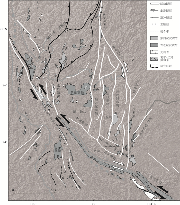
图 1 滇中地区及邻近地区地质简图(修改自Cao et al., 2021)
Fig. 1. The structural sketch map of the Central Yunnan terrane and adjacent area (modified from Cao et al., 2021)
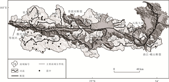
图 2 普渡河断裂区域提取的亚流域盆地
Fig. 2. Shaded relief map with the drainage basins extracted for the Puduhe fault
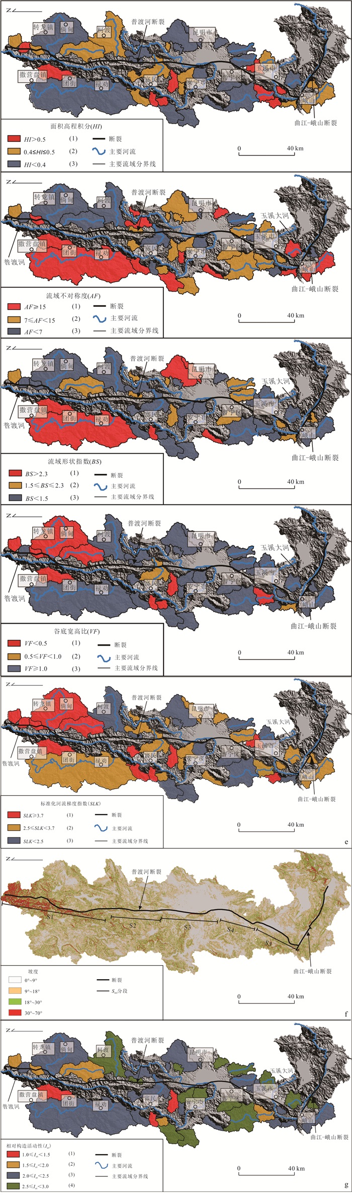
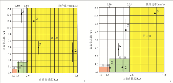
图 3 五种地貌指数数值及相对构造活动分类
a. 面积高程积分(HI);b. 流域盆地不对称度(AF);c. 流域形状指数(BS);d.谷底宽度与谷间高度比(VF);e.标准化河流梯度指数(SLK);f.坡度及Smf分段;g.相对构造活动分类
Fig. 3. Five geomorphic index values and classification of relative tectonic activities for drainage basins
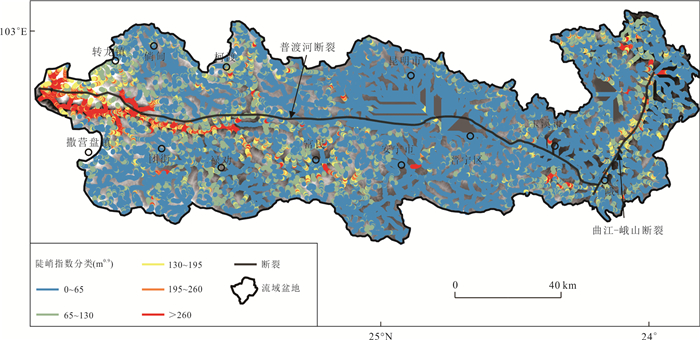
图 5 普渡河断裂流域河网陡峭指数分布
Fig. 5. Steepness indices distribution of river network in Puduhe Fault River Basin
表 1 构造活动性分析中的地貌指数
Table 1. Summary and explanation of morphometric parameters used in tectonic landform analysis
地貌指数 公式 示意图 面积高程积分(HI) HI=(Haver - Hmin)/(Hmax - Hmin) 
流域形状指数(BS) BS = Bl / Bw 
流域盆地不对称度(AF) AF = 100(Ar/At) 
标准化河流阶梯指数(SLK) SL =ΔH/ΔL×L
K = Htotal / ln(Ltotal)
SLK = SL/K
谷底宽度与谷间高度比(VF) VF = 2Vfw / [(Eld - Esc)+(Erd - Esc)] 
山前曲折度(Smf) Smf=Lmf/Ls 
注:据Figueroa and Knott, 2010; Cheng et al., 2018 . 下载: 导出CSV
-
Allen, C. R., Gillespie, A. R., Han, Y. A., et al., 1984. Red River and Associated Faults, Yunnan Province, China: Quaternary Geology, Slip Rates, and Seismic Hazard. Geological Society of America Bulletin, 95(6): 686. https://doi.org/10.1130/0016-7606(1984)95686: rraafy>2.0.co;2 doi: 10.1130/0016-7606(1984)95686:rraafy>2.0.co;2 An, X. W., Chang, Z. F., Chen, N. J., et al., 2018. Quaternary Active Faults in Yunnan and Distribution Map of Quaternary Active Faults in Yunnan. Seismological Press, Beijing (in Chinese). Bull, W. B., 2009. Tectonic Geomorphology of Mountains: A New Approach to Paleoseismology. In: Ravazzi, C., Orombelli, G., Donegana, M., et al., eds., Quaternary Research in the Southern Alps of Italy. Quaternary International, 204(1-2): 105-106. https://doi.org/10.1016/j.quaint.2009.03.001 Bull, W. B., McFadden, L. D., 1977. Tectonic Geomorphology North and South of the Garlock Fault, California. Synthetic Metals, 14(8): 115-136. https://doi.org/10.1016/S0379-6779(00)01411-9 Burchfiel, B. C., Wang, E., 2003. Northwest-Trending, Middle Cenozoic, Left-Lateral Faults in Southern Yunnan, China, and Their Tectonic Significance. Journal of Structural Geology, 25(5): 781-792. https://doi.org/10.1016/S0191-8141(02)00065-2 Cao, K., Leloup, P. H., Wang, G. C., et al., 2021. Thrusting, Exhumation, and Basin Fill on the Western Margin of the South China Block during the India-Asia Collision. GSA Bulletin, 133(1-2): 74-90. https://doi.org/10.1130/b35349.1 Cheng, Y. L., He, C. Q., Rao, G., et al., 2018. Geomorphological and Structural Characterization of the Southern Weihe Graben, Central China: Implications for Fault Segmentation. Tectonophysics, 722: 11-24. https://doi.org/10.1016/j.tecto.2017.10.024 El Hamdouni, R., Irigaray, C., Fernández, T., et al., 2008. Assessment of Relative Active Tectonics, Southwest Border of the Sierra Nevada (Southern Spain). Geomorphology, 96(1-2): 150-173. https://doi.org/10.1016/j.geomorph.2007.08.004 Faghih, A., Nezamzadeh, I., Kusky, T. M., 2016. Geomorphometric Evidence of an Active Pop-up Structure along the Sabzpushan Fault Zone, Zagros Mountains, SW Iran. Journal of Earth Science, 27(6): 945-954. https://doi.org/10.1007/s12583-016-0663-y Figueroa, A. M., Knott, J. R., 2010. Tectonic Geomorphology of the Southern Sierra Nevada Mountains (California): Evidence for Uplift and Basin Formation. Geomorphology, 123(1-2): 34-45. https://doi.org/10.1016/j.geomorph.2010.06.009 Gilley, L. D., Harrison, T. M., Leloup, P. H., et al., 2003. Direct Dating of Left-Lateral Deformation along the Red River Shear Zone, China and Vietnam. Journal of Geophysical Research: Solid Earth, 108(B2): 2127. https://doi.org/10.1029/2001jb001726 Goren, L., Fox, M., Willett, S. D., 2014. Tectonics from Fluvial Topography Using Formal Linear Inversion: Theory and Applications to the Inyo Mountains, California. Journal of Geophysical Research: Earth Surface, 119(8): 1651-1681. https://doi.org/10.1002/2014jf003079 Guo, S. M., 2001. Red River Active Fault Zone: A Special Study on Active Faults in China. Ocean Press, Beijing (in Chinese). Hack, J. T., 1973. Stream-Profile Analysis and Stream-Gradient Index. Journal of Research of the U. S. Geological Survey, 1(4): 421-429. He, H. L., Fang, Z. J., Li, P., 1993. A Preliminary Approach to the Fault Activity of Southern Segment on Xiaojiang West Branch Fault. Journal of Seismological Research, 16(3): 291-298 (in Chinese with English abstract). http://en.cnki.com.cn/Article_en/CJFDTOTAL-DZYJ199303009.htm He, Z. Q., An, H. S., Shen, K., et al., 2013. Detection of Puduhe Fault in Yuxi Basin of Yunnan by Seismic Reflection Method. Acta Seismologica Sinica, 35(6): 836-847 (in Chinese with English abstract). doi: 10.3969/j.issn.0253-3782.2013.06.007 Howard, A. D., Kerby, G., 1983. Channel Changes in Badlands. Geological Society of America Bulletin, 94(6): 739-752. https://doi.org/10.1130/0016-7606(1983)94739: ccib>2.0.co;2 doi: 10.1130/0016-7606(1983)94739:ccib>2.0.co;2 Kirby, E., Whipple, K. X., 2012. Expression of Active Tectonics in Erosional Landscapes. Journal of Structural Geology, 44: 54-75. https://doi.org/10.1016/j.jsg.2012.07.009 Leloup, P. H., Lacassin, R., Tapponnier, P., et al., 1995. The Ailao Shan-Red River Shear Zone (Yunnan, China), Tertiary Transform Boundary of Indochina. Tectonophysics, 251(1-4): 3-10, 13-84. https://doi.org/10.1016/0040-1951(95)00070-4 Li, S. H., Su, T., Spicer, R. A., et al., 2020. Oligocene Deformation of the Chuandian Terrane in the SE Margin of the Tibetan Plateau Related to the Extrusion of Indochina. Tectonics, 39(7): e2019TC005974. https://doi.org/10.1029/2019tc005974 Marshall, J. A., Roering, J. J., 2014. Diagenetic Variation in the Oregon Coast Range: Implications for Rock Strength, Soil Production, Hillslope Form, and Landscape Evolution. Journal of Geophysical Research: Earth Surface, 119(6): 1395-1417. https://doi.org/10.1002/2013jf003004 Qiao, X. J., Wang, Q., Du, R. L., 2004. Characteristics of Current Crustal Deformation of Active Blocks in the Sichuan-Yunnan Region. Chinese Journal of Geophysics, 47(5): 806-812 (in Chinese with English abstract). http://www.mendeley.com/research/characteristics-current-crustal-deformation-active-blocks-sichuan/ Replumaz, A., Lacassin, R., Tapponnier, P., et al., 2001. Large River Offsets and Plio-Quaternary Dextral Slip Rate on the Red River Fault (Yunnan, China). Journal of Geophysical Research: Solid Earth, 106(B1): 819-836. https://doi.org/10.1029/2000jb900135 Sağlam Selçuk, A., 2016. Evaluation of the Relative Tectonic Activity in the Eastern Lake Van Basin, East Turkey. Geomorphology, 270: 9-21. https://doi.org/10.1016/j.geomorph.2016.07.009 Strahler, A. N., 1952. Hypsometric (Area-Altitude) Analysis of Erosional Topography. Geological Society of America Bulletin, 63(11): 1117-1142. https://doi.org/10.1130/0016-7606(1952)63[1117: HAAOET]2.0.CO;2 doi: 10.1130/0016-7606(1952)63[1117:HAAOET]2.0.CO;2 Su, Q., Yuan, D. Y., Xie, H., et al., 2016. Geomorphic Features of the Shule River Drainage Basin in Qilianshan and Its Insight into Tectonic Implications. Seismology and Geology, 38(2): 240-258 (in Chinese with English abstract). doi: 10.3969/j.issn.0253-4967.2016.02.002 Wang, D., Dong, Y. P., Jiao, Q. Q., et al., 2021. The Mechanism of Tectonic Deformation of the Central Yunnan Terrane in the Late Cenozoic Based on Tectonic Geomorphology. Earth Science, 47(8): 3016-3028 (in Chinese with English abstract). Wang, E., Burchfiel, B. C., 1997. Interpretation of Cenozoic Tectonics in the Right-Lateral Accommodation Zone between the Ailao Shan Shear Zone and the Eastern Himalayan Syntaxis. International Geology Review, 39(3): 191-219. https://doi.org/10.1080/00206819709465267 Wang, E., Burchfiel, B. C., Royden, L. H., et al., 1998. Late Cenozoic Xianshuihe-Xiaojiang, Red River, and Dali Fault Systems of Southwestern Sichuan and Central Yunnan, China. Special Paper of the Geological Society of America, 327: 1-108. Wang, E. Q., Burchfiel, B. C., Royden, L. H., et al., 1995. Late Cenozoic Compressional Deformations and Their Origin along the Xiaojiang Strike-Slip Fault System in Central Yunnan China. Chinese Journal of Geology (Scientia Geologica Sinica), 30(3): 209-219 (in Chinese with English abstract). Wang, G., Wang, E. Q., 2005. Extensional Structures within the Compressional Orogenic Belt and Its Mechanism: A Case Study for the Late Cenozoic Deformation in Central Yunnan. Seismology and Geology, 27(2): 188-199 (in Chinese with English abstract). doi: 10.3969/j.issn.0253-4967.2005.02.002 Wang, J. H., Yin, A., Harrison, T. M., et al., 2001. A Tectonic Model for Cenozoic Igneous Activities in the Eastern Indo-Asian Collision Zone. Earth and Planetary Science Letters, 188(1-2): 123-133. https://doi.org/10.1016/S0012-821X(01)00315-6 Wang, Y. Z., Zhang, H. P., Zheng, D. W., et al., 2014. Controls on Decadal Erosion Rates in Qilian Shan: Re-Evaluation and New Insights into Landscape Evolution in North-East Tibet. Geomorphology, 223: 117-128. https://doi.org/10.1016/j.geomorph.2014.07.002 Wang, Y. Z., Zheng, D. W., Zhang, H. P., et al., 2020. Activity Characteristics of the Huashan Piedmont Normal Fault: Insights from Fluvial Geomorphic Parameters. Seismology and Geology, 42(2): 382-398 (in Chinese with English abstract). doi: 10.3969/j.issn.0253-4967.2020.02.009 Whipple, K. X., Tucker, G. E., 1999. Dynamics of the Stream-Power River Incision Model: Implications for Height Limits of Mountain Ranges, Landscape Response Timescales, and Research Needs. Journal of Geophysical Research: Solid Earth, 104(B8): 17661-17674. https://doi.org/10.1029/1999jb900120 Willett, S. D., 1999. Orogeny and Orography: The Effects of Erosion on the Structure of Mountain Belts. Journal of Geophysical Research: Solid Earth, 104(B12): 28957-28981. https://doi.org/10.1029/1999jb900248 Wu, K., Dong, Y. P., Duan, J. X., et al., 2020. Cenozoic Uplift of the Central Yunnan Fragment, Southwestern China, Revealed by Apatite (U-Th)/He Dating. Journal of Earth Science, 31(4): 735-742. https://doi.org/10.1007/s12583-020-1328-4 Yu, W. X., Xie, Y. Q., Zhang, J. G., et al., 2004. Age Studies of Major Active Faults around Kunming Basin. Journal of Seismological Research, 27(4): 357-362 (in Chinese with English abstract). doi: 10.3969/j.issn.1000-0666.2004.04.014 Zhang, P. Z., 2008. Current Tectonic Deformation, Strain Distribution and Deep Dynamic Process in Western Sichuan on the Eastern Margin of Qinghai-Tibet Plateau. Scientia Sinica Terrae, 38(9): 1041-1056 (in Chinese). Zhang, P. Z., Deng, Q. D., Zhang, Z. Q., et al., 2013. Active Faults, Earthquake Disasters and Their Dynamic Processes in Chinese Mainland. Scientia Sinica Terrae, 43(10): 1607-1620 (in Chinese). doi: 10.1360/zd-2013-43-10-1607 Zhu, T., Zhou, J. G., Shen, K., et al., 2012. Application of Electrical Resistivity Tomography to the Detection of Pudu River Fault in Yuxi Basin. Seismology and Geology, 34(3): 467-476 (in Chinese with English abstract). doi: 10.3969/j.issn.0253-4967.2012.03.008 安晓文, 常祖峰, 陈宁军, 等, 2018. 云南第四纪活动断裂暨《云南第四纪活动断裂分布图》. 北京: 地震出版社. 虢顺民, 2001. 红河活动断裂带: 中国活断层研究专辑. 北京: 海洋出版社. 何宏林, 方仲景, 李玶, 1993. 小江断裂带西支断裂南段新活动初探. 地震研究, 16(3): 291-298. 何正勤, 安好收, 沈坤, 等, 2013. 用地震反射法对玉溪盆地普渡河断裂的探测. 地震学报, 35(6): 836-847. doi: 10.3969/j.issn.0253-3782.2013.06.007 乔学军, 王琪, 杜瑞林, 2004. 川滇地区活动地块现今地壳形变特征. 地球物理学报, 47(5): 806-812. 苏琦, 袁道阳, 谢虹, 等, 2016. 祁连山西段疏勒河流域地貌特征及其构造意义. 地震地质, 38(2): 240-258. doi: 10.3969/j.issn.0253-4967.2016.02.002 王丹, 董有浦, 焦骞骞, 等, 2022. 滇中地块新生代晚期的变形机制: 基于构造地貌学分析. 地球科学, 47(8): 3016-3028. doi: 10.3799/dqkx.2021.146 王二七, Burchfiel, B. C., Royden, R. H., 等, 1995. 滇中小江走滑剪切带晚新生代挤压变形研究. 地质科学, 30(3): 209-219. 王刚, 王二七, 2005. 挤压造山带中的伸展构造及其成因——以滇中地区晚新生代构造为例. 地震地质, 27(2): 188-199. doi: 10.3969/j.issn.0253-4967.2005.02.002 王一舟, 郑德文, 张会平, 等, 2020. 华山山前正断层的分段活动特征——来自河流地貌参数的约束. 地震地质, 42(2): 382-398. doi: 10.3969/j.issn.0253-4967.2020.02.009 俞维贤, 谢英情, 张建国, 等, 2004. 昆明盆地周边地区主要断裂活动时代研究. 地震研究, 27(4): 357-362. doi: 10.3969/j.issn.1000-0666.2004.04.014 张培震, 2008. 青藏高原东缘川西地区的现今构造变形、应变分配与深部动力过程. 中国科学: 地球科学, 38(9): 1041-1056. doi: 10.3321/j.issn:1006-9267.2008.09.001 张培震, 邓起东, 张竹琪, 等, 2013. 中国大陆的活动断裂、地震灾害及其动力过程. 中国科学: 地球科学, 43(10): 1607-1620. 朱涛, 周建国, 沈坤, 等, 2012. 玉溪盆地内普渡河断裂的电阻率层析成像探测. 地震地质, 34(3): 467-476. doi: 10.3969/j.issn.0253-4967.2012.03.008 -

 点击查看大图
计量
- 文章访问数: 191
- HTML全文浏览量: 125
- PDF下载量: 36
- 被引次数: 0
