


Prediction of Quaternary Cover Thickness and 3D Geological Modeling Based on BP Neural Network
-
摘要: 地质灾害风险精细化调查和评估是目前地质灾害减灾防控的重要内容. 斜坡三维地质建模技术的发展为滑坡灾害风险精细化调查评估提供了新的思路,可大幅提高区域范围内滑坡灾害调查的效率和评估精度. 基于Skua-Gocad平台,针对第四系覆盖物和下伏基岩两大模块开展区域斜坡三维地质建模技术研究,以重庆市万州区大周镇为例,采用BP神经网络模型,通过构建研究区第四系覆盖物厚度与地质环境指标的多维非线性网络实现了第四系覆盖物厚度预测. 结合现场调查数据进行方法验证,基于BP神经网络的第四系覆盖物厚度预测精度达91.49%,在此基础上构建了三维地质模型,具有良好的可视化效果,并确保了数据的可靠性. 克服了传统基于克里金插值方法无法反应地质环境因素的缺点,解决了区域范围第四系覆盖物厚度预测的难题.Abstract: Fine investigation and assessment of geological disaster risk is an important part of prevention and control of geological disaster reduction at present. The development of 3D slope geological modeling technology provides a new idea for detailed investigation and assessment of landslide hazard risk, which can greatly improve the efficiency and assessment accuracy of landslide hazard investigation in the region.In this paper, based on Skua-Gocad platform, three-dimensional geological modeling technology of regional slope is studied for two modules of Quaternary cover and underlying bedrock. Taking Dazhou Town, Wanzhou District, Chongqing as an example, BP neural network model is used to predict the thickness of Quaternary cover by building a multi-dimensional nonlinear network of Quaternary cover thickness and geological environment indicators in the study area.Combined with the field survey data, the method is verified, and the prediction accuracy of Quaternary cover thickness based on BP neural network reaches 91.49%. On this basis, a 3D geological model is built, which has good visualization effect and ensures the reliability of data.It overcomes the shortcoming of traditional Kriging interpolation method that can't reflect geological environment factors, and solves the difficult problem of prediction of Quaternary cover thickness in regional scope.
-
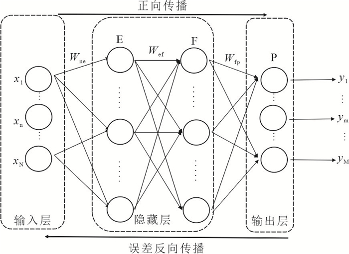
图 1 两层隐藏层的BP神经网络结构图
Fig. 1. BP neural network structure diagram with two hidden layers
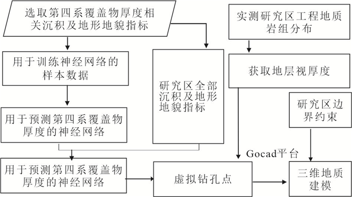
图 2 神经网络预测第四系覆盖物厚度及三维建模流程图
Fig. 2. Prediction of Quaternary Cover Thickness by Neural Network and Flow Chart of 3D Modeling
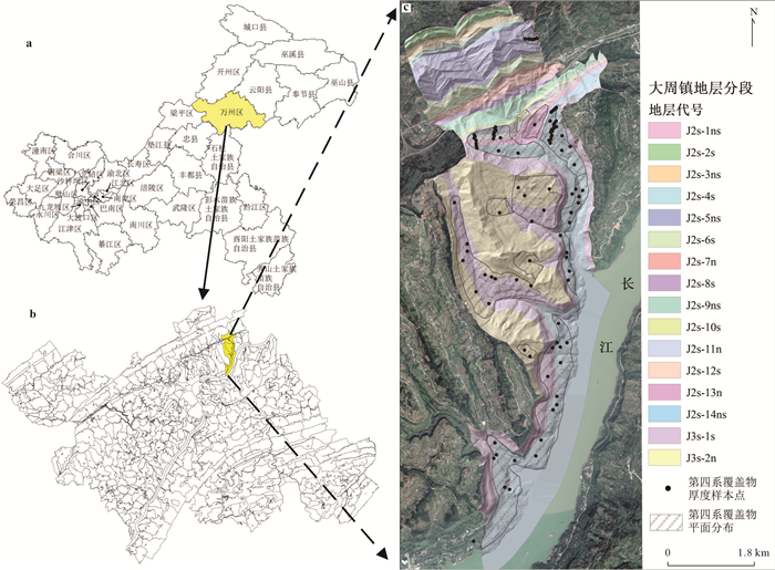
图 3 大周镇位置与地层分段及第四系覆盖物厚度样本点分布图
a.重庆市区划;b.万州区乡镇分布;c.大周镇平面图
Fig. 3. Location of Dazhou Town, stratigraphic segmentation and distribution map of sample points of quaternary accumulation layer thickness
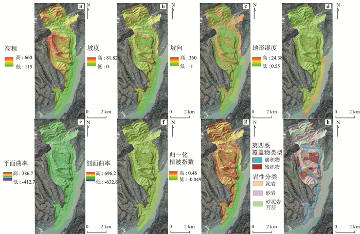
图 4 研究区指标因子图
a.高程;b.坡度;c.坡向;d.地形湿度;e.平面曲率;f.剖面曲率;g.归一化植被指数;h.第四系覆盖物类型及岩性分类
Fig. 4. Index factor diagram of study area
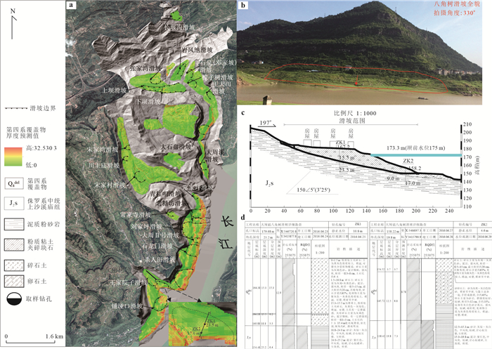
图 5 大周镇第四系平面覆盖物厚度预测结果与实地勘察对比图
a.大周镇第四系覆盖物厚度预测平面分布图;b.大周镇八角树滑坡全貌图;c.八角树滑坡1-1’工程地质剖面图;d.八角树滑坡钻孔柱状图
Fig. 5. Plane distribution of Quaternary cover thickness prediction in Dazhou Town and comparison with field investigation
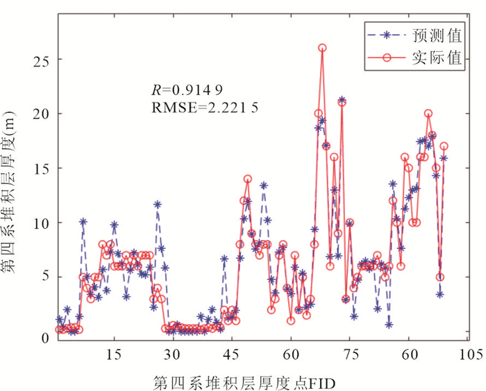
图 6 第四系覆盖物厚度预测值与真实值对比
Fig. 6. Comparison between predicted and true values of Quaternary accumulation layer thickness
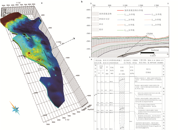
图 7 基于大周镇三维模型的虚拟工程地质剖面图与实地钻孔柱状图
Fig. 7. Virtual engineering geological profile and field borehole histogram based on 3D model of Dazhou Town
表 1 沉积及地形地貌指标及选取原因
Table 1. Deposit and topographic indicators and selection reasons
地形地貌因素 选取原因 归一化植被指数 第四系覆盖物对植被演化具有关键作用,植被覆盖也反映地区第四系覆盖物厚度(柴强, 2015) 高程 与第四系覆盖物厚度具有显著相关性,根据高程不同具有垂直分布特点(Penížek and Borůvka, 2006) 坡度 Ziadat et al.(2010)从DEM栅格图层中提取地形指标预测土壤厚度,利用实地测量的土壤厚度数据与预测数值做对比,结果显示土壤厚度与坡度及坡向指标呈显著的正相关 坡向 平面曲率 Patton et al.(2018)建立第四系覆盖物厚度-曲率关系模型,结果表示两者具有相关度的线性关系 剖面曲率 地形湿度 第四系覆盖物厚度易受流水搬运及库岸堆积影响,地形湿度直接影响覆盖物运移(Mehnatkesh et al., 2013) 第四系覆盖物类型 风化、崩落方式而形成的残积、崩积物影响第四系覆盖物厚度 软硬岩性 第四系覆盖物的下伏基岩软硬程度为第四系覆盖物急供聚集基础(孙立群等, 2021)  下载: 导出CSV
表 2 第四系覆盖物厚度预测值与实测值对比
Table 2. Comparison between predicted and measured valuesof Quaternary covering thickness
钻孔编号 实测值(m) 预测值(m) 绝对误差(m) 相对误差 ZK1 18.8 12.90 5.90 31.38% ZK2 12.5 8.78 3.72 29.76%
下载: 导出CSV
-
Cascini, L., Ciurleo, M., Di Nocera, S., 2016. Soil Depth Reconstruction for the Assessment of the Susceptibility to Shallow Landslides in Fine-Grained Slopes. Landslides, 14(2): 459-471. https://doi.org/10.1007/s10346-016-0720-8 Chai, Q., 2015. The Analysis about Soil Main Properties and Its Influence Factors of Grassland in Xinjiang(Dissertation). Xinjiang Agricultural University, Xinjian(in Chinese with English abstract). Che, D. F., Jia, Q. R., 2019. Three-Dimensional Geological Modeling of Coal Seams Using Weighted Kriging Method and Multi-Source Data. IEEE Access, 7: 118037-118045. https://doi.org/10.1109/access.2019.2936811 Chen, S., Chen, G. J., Xu, G. L., 2008. Mechanism of Geological Processes of Formation and Deformation of the Huangtupo Landslide. Earth Science, 33(3): 411-415(in Chinese with English abstract). doi: 10.3321/j.issn:1000-2383.2008.03.017 Chen, Y. Y., Li, Y. Q., Wei, D. T., et al., 2021. Quantitative Relationship between Tectonic Deformation and Topography in Bogda Piedmont of Eastern Tianshan Mountains: Based on 3D Structural Modeling and Geomorphic Analysis. Earth Science, 47(2): 418-436(in Chinese with English abstract). Clyde, W. C., Fisher, D. C., 1997. Comparing the Fit of Stratigraphic and Morphologic Data in Phylogenetic Analysis. Paleobiology, 23(1): 1-19. https://doi.org/10.1017/s0094837300016614 Houlding, S. W., 1992. Subsurface Contaminant Assessment by 3D Geoscience Modeling. In: Singhal, R. K., Mehrotra, A. K., Fytas, K., eds., Environmental Issues and Management of Waste in Energy and Mineral, AA Balkema, Calgary, Canada, 1355-1362. Jiang, T. Y., Cui, L. L., Li, J. H., 2012. An Implementation of 3D Landslide Geological Modeling and Visualization. Advanced Materials Research, 594-597: 2338-2343. https://doi.org/10.4028/www.scientific.net/amr.594-597.2338 Kuriakose, S. L., Devkota, S., Rossiter, D. G., et al., 2009. Prediction of Soil Depth Using Environmental Variables in an Anthropogenic Landscape, a Case Study in the Western Ghats of Kerala, India. CATENA, 79(1): 27-38. https://doi.org/10.1016/j.catena.2009.05.005 Li, M. C., Bai, S., Kong, R., et al., 2020. 3D Parametric Modeling Method of Engineering-Scale Geological Structures. Chinese Journal of Rock Mechanics and Engineering, 39(Supp. 1): 2848-2858(in Chinese with English abstract). Liu, L., Yin, K. L., Zhang, J., 2016. Estimation Method of the Quaternary Deposits Thickness and Its Application in Wanzhou Central District, Three Gorges Reservoir Region. Bulletin of Geological Science and Technology, 35(1): 177-183(in Chinese with English abstract). Mehnatkesh, A., Ayoubi, S., Jalalian, A., et al., 2013. Relationships between Soil Depth and Terrain Attributes in a Semi Arid Hilly Region in Western Iran. JournalofMountainScience, 10(1): 163-172. https://doi.org/10.1007/s11629-013-2427-9 Miu, X., 2016, Research on Landslide Risk Assessment Considering the States of Slope Activity: A Case of Fengjie New County(Dissertation), Chengdu University of Technology, Chengdu(in Chinese with English abstract). Muzik, J., Vondráčková, T., Sitányiová, D., et al., 2015. Creation of 3D Geological Models Using Interpolation Methods for Numerical Modelling. Procedia Earth and Planetary Science, 15: 25-30. https://doi.org/10.1016/j.proeps.2015.08.007 Na, W. B., Su, Z. W., Zhang, P., 2013. Research of Oilfield Production Forecast Based on Least Squares Fitting and Improved BP Neural Network. Applied Mechanics and Materials, 333-335: 1456-1460. https://doi.org/10.4028/www.scientific.net/amm.333-335.1456 Patton, N. R., Lohse, K. A., Godsey, S. E., et al., 2018. Predicting Soil Thickness on Soil Mantled Hillslopes. Nature Communications, 9(1). https://doi.org/10.1038/s41467-018-05743-y Penížek, V., Borůvka, L., 2006. Soil Depth Prediction Supported by Primary Terrain Attributes: A Comparison of Methods. Plant, SoilandEnvironment, 52(9): 424-430. https://doi.org/10.17221/3461-pse Shen, J., Xu, D. W., Cai, J, X., 2008. 3D Geological Modeling of Landslides Based on Borehole Data. Journal of East China University of Technology(Natural Science), 31(2): 127-130(in Chinese with English abstract). Thak, J. H., Ryu, T. G., Sin, J. S., et al., 2021. Digital Terrain Analysis Approach to Improve Soil Depth Prediction with Parent Material Dataset. Eurasian Soil Science, 54(12): 1818-1825. https://doi.org/10.1134/s1064229321120139 Wang, J. M., Zhao, H., Bi, L., et al., 2018. Implicit 3D Modeling of Ore Body from Geological Boreholes Data Using Hermite Radial Basis Functions. Minerals, 8(10): 443. https://doi.org/10.3390/min8100443 Wang, Y., Zhang, X. Y., Chen, W. J., et al., 2017. Application of Virtual Boreholes in 3D Deep Geological Modeling. Urban Geology, 12(2): 118-122(in Chinese with English abstract). Wen, C. M., 2018. 3D Geological Modeling Technology And Tts Application Tn a Mine. In: 3rd International Conference on Smart City and Systems Engineering(ICSCSE), IEEE, China, 809-812. Xiong, Z. Q., 2007. Study on the Technology of 3D Engineering Geological Modeling and Visualization(PhD thesis). The Chinese Academy of Sciences(Institute of Rock & Soil Mechanics), Wuhan(in Chinese with English abstract). Yan, Z., 2015. Research and Application on BP Neural Network Algorithm. In: International Industrial Informatics and Computer Engineering Conference in Peoples R China 2015, Xi'an, 1444-1447. Yang, L., Song, M. L., 2009. Research on BP Neural Network for Nonlinear Economic Modeling and Its Realization Based on Matlab. In: Luo, Q., Song, M., eds., 3rd International Symposium on Intelligent Information Technology Application, IEEE, Nanchang, 505. Yi, X. S., Li, G. S., Yin, Y. Y., et al., 2012. Comparison on Soil Depth Prediction among Different Spatial Interpolation Methods: A Case study in the Three-River Headwaters Region of Qinghai Province. Geographical Research, 31(10): 1793-1805(in Chinese with English abstract). Yip, H. J., Ji, G. R., Liu, J. H., et al., 2016. Optimal Structure and Parameters of BP Neural Network for Curve Fitting Problem. In: Jing, W., Guiran, C., Huiyu, Z., eds., 6th International Conference on Electronic, Mechanical, Information and Management Society (EMIM), Shenyang, 40: 1647-1652. Zhang, L. Q., Zhang, X., Liang, X., et al., 2021. Identification and Characteristics of the Sedimentary Environment since the Quaternary in Zi River Delta, Dongting Basin. Earth Science, 46(9): 3245-3257(in Chinese with English abstract). Zhang, M. S., Tang, Y. M., 2008. Risk Investigation Method and Practice of Geohazards. Geological Bulletin of China, 27(8): 1205-1216(in Chinese with English abstract). doi: 10.3969/j.issn.1671-2552.2008.08.017 Zhang, W. T., Hu, G. Q., Sheng, J. D., et al., 2018. Estimating Effective Soil Depth at Regional Scales: Legacy Maps versus Environmental Covariates. Journal of Plant Nutrition and Soil Science, 181(2): 167-176. https://doi.org/10.1002/jpln.201700081 Zhu, D. P., Niu, W. J., Yang, Q., et al., 2001. 3 Dimension visualization for Geology-Constructed-Model. Journal of Beijing University of Aeronautics and Astronautics, 27(4): 448-451(in Chinese with English abstract). doi: 10.3969/j.issn.1001-5965.2001.04.018 Zhu, L. F., Wang, X. F., Zhang, B., 2014. Modeling and Visualizing Borehole Information on Virtual Globes Using KML. Computers & Geosciences, 62(1): 62-70. https://doi.org/10.1016/j.cageo.2013.09.016 Ziadat, F. M., 2010. Prediction of Soil Depth from Digital Terrain Data by Integrating Statistical and Visual Approaches. Pedosphere, 20(3): 361-367. https://doi.org/10.1016/s1002-0160(10)60025-2 柴强, 2015. 新疆草地土壤主要性质及影响因素的分析(硕士学位论文). 新疆: 新疆农业大学. 陈松, 陈国金, 徐光黎, 2008. 黄土坡滑坡形成与变形的地质过程机制. 地球科学, 33(3): 411-415. doi: 10.3321/j.issn:1000-2383.2008.03.017 陈莹莹, 李一泉, 魏东涛, 等, 2022. 东天山博格达山前构造变形与地形定量关系: 基于三维建模与地貌分析. 地球科学, 47(2): 418-436. doi: 10.3799/dqkx.2021.097 杜文凤, 彭苏萍, 2010. 利用地质统计学预测煤层厚度. 岩石力学与工程学报, 29(增1): 2762-2767. https://www.cnki.com.cn/Article/CJFDTOTAL-YSLX2010S1028.htm 李明超, 白硕, 孔锐, 等, 2020. 工程尺度地质结构三维参数化建模方法. 岩石力学与工程学报, 39(增1): 2848-2858. https://www.cnki.com.cn/Article/CJFDTOTAL-YSLX2020S1026.htm 刘磊, 殷坤龙, 张俊, 2016. 三峡库区万州主城区第四系堆积层厚度的估算方法及应用. 地质科技情报, 35(1): 177-183. https://www.cnki.com.cn/Article/CJFDTOTAL-DZKQ201601028.htm 缪信, 2016. 考虑斜坡活动性状态的滑坡风险评价技术研究——以奉节新城区为例(硕士学位论文). 成都: 成都理工大学. 申健, 徐大伟, 蔡雄翔, 2008. 基于钻孔数据的滑坡三维地质建模研究. 东华理工大学学报(自然科学版), 31(2): 127-130. https://www.cnki.com.cn/Article/CJFDTOTAL-HDDZ200802006.htm 孙立群, 张鑫, 梁杏, 等, 2021. 洞庭盆地资水三角洲地区第四纪沉积环境判别及其特征. 地球科学, 46(9): 3245-3257. doi: 10.3799/dqkx.2020.357 王瑶, 张像源, 陈文杰, 等, 2017. 虚拟钻孔在深层三维地质建模中的应用. 城市地质, 12(2): 118-122. https://www.cnki.com.cn/Article/CJFDTOTAL-CSDZ201702027.htm 熊祖强, 2007. 工程地质三维建模及可视化技术研究(博士学位论文). 武汉: 中国科学院研究生院(武汉岩土力学研究所). 易湘生, 李国胜, 尹衍雨, 等, 2012. 土壤厚度的空间插值方法比较——以青海三江源地区为例. 地理研究, 31(10): 1793-1805. https://www.cnki.com.cn/Article/CJFDTOTAL-DLYJ201210006.htm 张茂省, 唐亚明, 2008. 地质灾害风险调查的方法与实践. 地质通报, 27(8): 1205-1216. https://www.cnki.com.cn/Article/CJFDTOTAL-ZQYD200808021.htm 朱大培, 牛文杰, 杨钦, 等, 2001. 地质构造的三维可视化. 北京航空航天大学学报, 27(4): 448-451. https://www.cnki.com.cn/Article/CJFDTOTAL-BJHK200104017.htm -

 点击查看大图
计量
- 文章访问数: 1262
- HTML全文浏览量: 790
- PDF下载量: 133
- 被引次数: 0
