


Mapping Bare Rock in Open-Pit Limestone Mining Area Using Gaofen-2 Satellite Image
-
摘要: 为了高效、准确地从高分辨率遥感影像中提取裸岩,利用国产高分二号(GF-2)影像数据,通过构建斜率差异裸岩指数模型(slope difference bare rock index,简称SDBRI)和裸岩阴影指数模型(bare rock shadow index,简称BRSI),提出了亚米级高分影像的露天矿区裸岩提取技术方案.以青州市南部山区为试验区对此方法进行检验,结果表明:在SDBRI指数图像中,裸岩能够与周边植被较好区分,裸岩与其他地物的可分性显著高于NDVI、CRI1、CRI2等指数模型;以基于谷歌地球高清影像的目视解译结果作为验证数据进行精度评估,交并比(IoU)指标达到91%左右.此方法能够满足基于国产高分影像数据进行大范围矿区裸岩制图的需求,可以为矿山环境的遥感监测提供技术支持,具有较强的实践价值.Abstract: In order to extract accurately and efficiently the bare rock from high-resolution remote sensing image, in this study it used Chinese Gaofen-2 (GF-2) satellite imagery as data source, the slope difference bare rock index (SDBRI) and bare rock shadow index (BRSI) for the extraction of bare rock and bare rock shadow were created, respectively. Based on the two index models, it proposed a strategy for sub-meter-level high-resolution image bare rock extraction in the open-pit mining area. Then the southern mountainous area of Qingzhou City, Shandong Province was selected as the test area. The results show follows: In the SDBRI index image, the values of the bare rock can be easily distinguished from the surrounding vegetation. And the separability of bare rock and other objectives is significantly higher than that of other index models such as NDVI, CRI1, and CRI2. The visual interpretation results from the Google Earth high resolution images are used as verification data for accuracy evaluation, and the IoU index reaches about 91%. The method proposed in this paper can meet the needs of large-scale open rock mapping in mining areas based on Chinese high-resolution image data, and can provide technical support for remote sensing monitoring of mine environment, which has strong practical value.
-
Key words:
- Gaofen-2 /
- sub-meter satellite image /
- open-pit mining area /
- index model /
- bare rock extraction /
- remote sensing
-
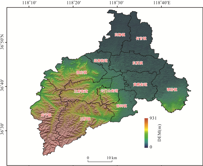
图 1 研究区地理位置及地貌特征
Fig. 1. Geographical location and geomorphologic characteristics of the study area
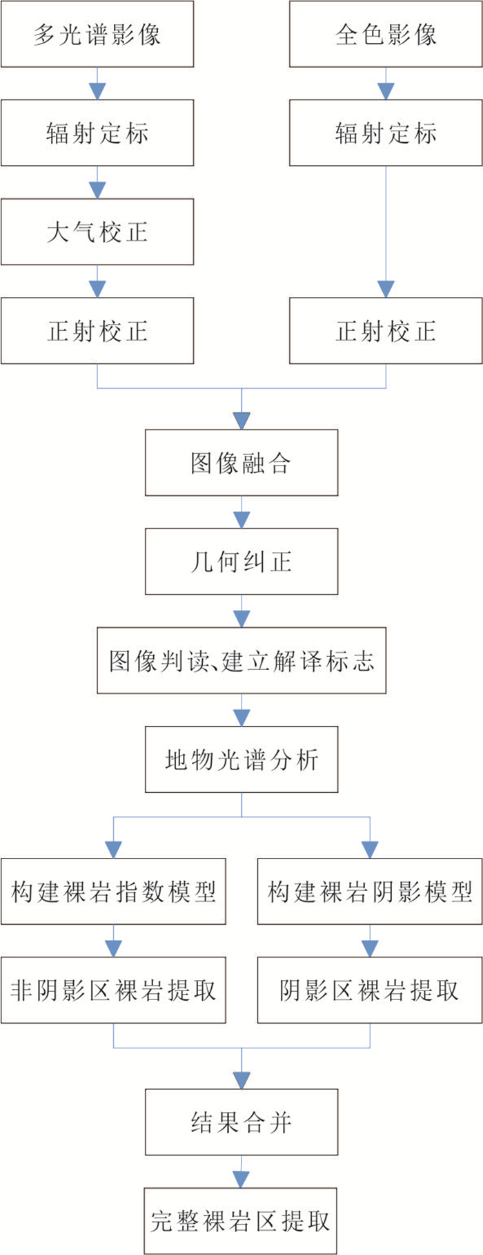
图 2 基于GF-2影像的裸岩提取技术路线
Fig. 2. The diagram of bare rock extraction based on GF-2 images
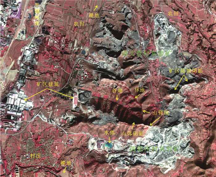
图 3 青州市南文登村灰岩矿和西郭庄村灰岩矿GF-2遥感影像图(4-3-2波段组合)
Fig. 3. GF-2 remote sensing image of the Nanwendeng and Xiguozhuang limestone mining areas (4-3-2 band combination)
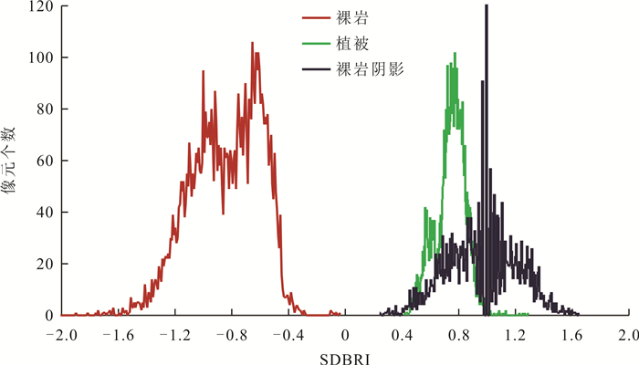
图 5 SDBRI图像裸岩、裸岩阴影、植被取值分布直方图
Fig. 5. Histogram of bare rock, bare rock shadow and vegetation in SDBRI image
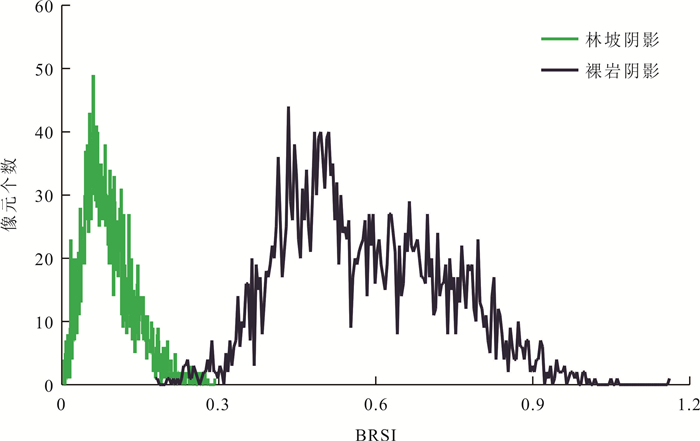
图 6 BRSI图像裸岩阴影、林坡阴影取值分布直方图
Fig. 6. Histogram of bare rock shadow and vegetation shadow in BRSI image
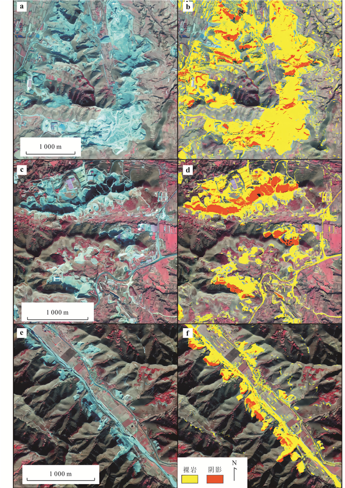
图 7 裸岩指数模型典型区域的提取结果
Fig. 7. Extraction results of the bare rock index model in 3 typical regions
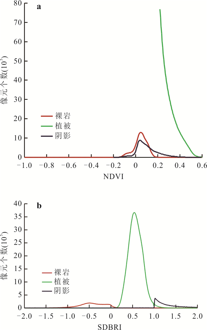
图 9 NDVI指数(a)和SDBRI指数(b)裸岩、植被、阴影统计直方图
Fig. 9. Statistical histograms of bare rock, vegetation and shadow in the NDVI index image (a) and SDBRI index image (b)
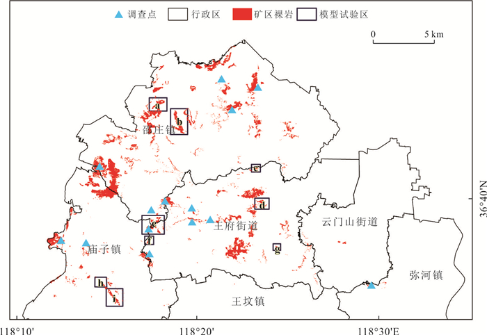
图 10 青州市西南山区灰岩矿区提取结果、模型验证区和现场调查点分布情况
Fig. 10. Extraction results of open-pit limestone mining area, model verification areas, and field survey points in the southwestern mountainous area of Qingzhou City
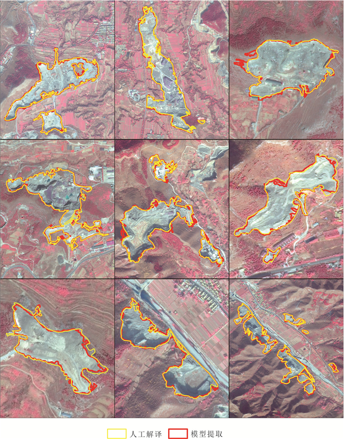
图 12 提取结果验证
Fig. 12. The comparison of model-derived results and visual interpretation results from Google Earth images
表 1 GF-2卫星有效载荷技术指标
Table 1. The technical specifications of GF-2 satellite payload
载荷 波段编号 波段范围(μm) 空间分辨率 幅宽 重访周期 全色多光谱相机(PMS) 1 0.45~0.90 0.8 m 45 km(2台相机组合) 侧摆时:5 d
不侧摆:69 d2 0.45~0.52 3.2 m 3 0.52~0.59 4 0.63~0.69 5 0.77~0.89  下载: 导出CSV
表 2 GF-2影像4-3-2波段组合下相关地物的影像特征和解译标志
Table 2. Image features and interpretation keys of relevant ground objects in the GF-2 images with 4-3-2 band combination
地物类型 影像特征 解译标志 矿区/裸岩 
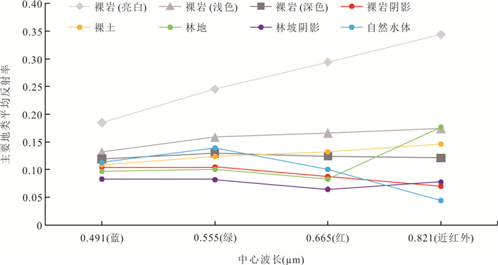
裸岩主要呈石板灰色,颜色有深有浅,形状不规则.露天矿区主要表现为大面积的裸露岩石,形态和颜色上不易与其他裸岩如干涸河床、建筑工程形成的裸岩等区分,但矿区裸岩常有开采活动导致的陡坎,会有阴影出现.另外,矿区周边有矿区建筑物、道路等 植被 
通常显示为红色,不同类型的植被色调、形状、纹理都会不一样.如山间林地多为不规则形状、深红色、颗粒状明显;山间草地为浅红褐色,常覆盖整片山坡,覆盖度不同色调会有差异 水体 
形状不一,人工水体形状多规则、自然水体不规则,颜色因水的深浅而不同,深水颜色为深蓝或黑色,随着水深变浅颜色也逐渐变为浅蓝、灰蓝.同时,水体颜色也会受到所含泥沙、有机物及其他物质的影响而呈现不同的颜色.如左图为矿区水体,整体较浅,随着深度的增加颜色也由浅蓝变为深蓝,浅水处有矿渣堆积 裸土 
多为无植被覆盖的农田,形状规则,常表现为深灰色或灰白色
下载: 导出CSV
表 3 裸岩信息的模型提取结果与人工解译结果
Table 3. The IoU information of the model-derived results and visual interpretation results from Google Earth images
验证区域 交集面积 并集面积 IoU (m2) (m2) a 288 770.500 309 676.760 93.24% b 524 881.000 568 072.771 92.40% c 219 625.020 249 511.285 88.02% d 65 071.458 72 017.129 90.36% e 294 757.971 319 765.366 92.18% f 326 084.314 360 207.762 90.53% g 74 858.900 80 378.748 93.13% h 156 444.232 168 631.982 92.77% i 24 943.370 28 347.101 87.99%
下载: 导出CSV
-
Chen, W. T., Li, X. J., Wang, L. Z., 2019. Fine Land Cover Classification in an Open Pit Mining Area Using Optimized Support Vector Machine and World View-3 Imagery. Remote Sensing, 12(1): 82. https://doi.org/10.3390/rs12010082 Jiang, H., Wang, X. Q., Chen, X., 2005. A Method for Abstraction of Vegetation Density from SPOT Image. Geo-Information Science, 7(4): 113-116 (in Chinese with English abstract). Kang, J., Cheng, X., Hui, F. M., et al., 2018. An Accurate and Automated Method for Identifying and Mapping Exposed Rock Outcrop in Antarctica Using Landsat 8 Images. IEEE Journal of Selected Topics in Applied Earth Observations and Remote Sensing, 11(1): 57-67. https://doi.org/10.1109/jstars.2017.2755502 Li, D. R., Ding, L., Shao, Z. F., 2021. Application-Oriented Real-Time Remote Sensing Service Technology. Journal of Remote Sensing, 25(1): 15-24 (in Chinese with English abstract). Li, H. K., Xu, F., Li, Q., 2020. Remote Sensing Monitoring of Land Damage and Restoration in Rare Earth Mining Areas in 6 Counties in Southern Jiangxi Based on Multisource Sequential Images. Journal of Environmental Management, 267: 110653. https://doi.org/10.1016/j.jenvman.2020.110653 Li, W. K., Zhang, W., Qin, J. H., et al., 2020. "Expansion-Fusion" Extraction of Surface Gully Area Based on DEM and High-Resolution Remote Sensing Images. Earth Science, 45(6): 1948-1955 (in Chinese with English abstract). Liao, X. H., 2021. Scientific and Technological Progress and Development Prospect of the Earth Observation in China in the Past 20 Years. Journal of Remote Sensing, 25(1): 267-275 (in Chinese with English abstract). Lin, N., Xu, Y. C., Gao, B. W., et al., 2021. Semi-Automatic Extraction of Triangular Facet Attitude Based on Edge Extraction Algorithm. Earth Science, 46(10): 3753-3763 (in Chinese with English abstract). Liu, B., Ge, D. Q., Li, M., et al., 2018. Using Ground-Based InSAR to Evaluate the Stability of an Open-Pit Slope under Blasting Operation. Journal of Remote Sensing, 22(S1): 139-145 (in Chinese with English abstract). Liu, J. L., 2018. Information Extraction of Open-Pit Limestone Mine Based on Remote Sensing. North China University of Science and Technology, Tangshan(in Chinese with English abstract). Maus, V., Giljum, S., Gutschlhofer, J., et al., 2020. A Global-Scale Data Set of Mining Areas. Scientific Data, 7(1): 289. https://doi.org/10.1038/s41597-020-00624-w Pei, J., Wang, L., Huang, N., et al., 2018. Analysis of Landsat-8 OLI Imagery for Estimating Exposed Bedrock Fractions in Typical Karst Regions of Southwest China Using a Karst Bare-Rock Index. Remote Sensing, 10(9): 1321. https://doi.org/10.3390/rs10091321 Shao, Y. X., Zou, X. B., Yuan, D. Y., et al., 2021. Late Quaternary Slip along Yangguan Fault at Northeastern Section of Altyn Tagh Fault and Implications for Seismic Risk. Earth Science, 46(2): 683-696(in Chinese with English abstract). Vorovencii, I., 2021. Changes Detected in the Extent of Surface Mining and Reclamation Using Multitemporal Landsat Imagery: A Case Study of Jiu Valley, Romania. Environmental Monitoring and Assessment, 193(1): 1-24. https://doi.org/10.1007/s10661-020-08834-w Wang, K. N., Wang, X. X., 2018. Temporal and Spatial Changes of Desertification Remote Sensing Parameters in Karst City. Science Technology and Engineering, 18(10): 284-289 (in Chinese with English abstract). Wang, M. J., 2019. Research on Information Extraction of Karst Rocky Desertification Based on Multi-Source Remote Sensing Data (Dissertation). Lanzhou University of Technology, Lanzhou (in Chinese with English abstract). Wang, Y. Y., Chen, R., Shen, C. Y., et al., 2020. Research on Remote Sensing Image Characteristics of Carbonate Rock Based on RS and GIS: An Example of Southern Guizhou Region. Carsologica Sinica, 39(5): 762-774 (in Chinese with English abstract). Wu, Q. H., Song, C. Q., Liu, K., et al., 2020. Integration of TanDEM-X and SRTM DEMs and Spectral Imagery to Improve the Large-Scale Detection of Opencast Mining Areas. Remote Sensing, 12(9): 1451. https://doi.org/10.3390/rs12091451 Xie, X. J., Du, P. J., Xia, J. S., et al., 2015. Spectral Indices for Estimating Exposed Carbonate Rock Fraction in Karst Areas of Southwest China. IEEE Geoscience and Remote Sensing Letters, 12(9): 1988-1992. https://doi.org/10.1109/LGRS.2015.2441962 Ye, J. L., He, Z. W., Weng, Z. Y., et al., 2012. Application of NDVI Pixel Binary Model in Extraction of Rocky Desertification in Karst Areas. Geospatial Information, 10(4): 134-136, 183 (in Chinese with English abstract). Zhang, J. D., Xi, F. R., 2020. Study on Ecological Restoration of Abandoned Mines in China. Acta Ecologica Sinica, 40(21): 7921-7930 (in Chinese with English abstract). Zhang, P. P., Hu, Y. M., Xiao, D. N., et al., 2010. A Method of the Percentage of Bare Rock Calculation in Karst Areas Based on Multi-Spectrum Remote Sensing Image. Remote Sensing Technology and Application, 25(4): 510-514 (in Chinese with English abstract). Zhang, Y. B., Liu, J. L., Ji, J., et al., 2018a. Texture Analysis and Object-Oriented Classification of Open Limestone Mines. Geology and Exploration, 54(2): 348-357 (in Chinese with English abstract). Zhang, Y. B., Liu, J. L., Li, S. B., et al., 2018b. Study on Automatic Extraction of Mining Range Information of Open-Pit Limestone Mine. Mining Research and Development, 38(6): 104-108 (in Chinese with English abstract). Zhang, Z. H., Liu, W., Li, X. H., et al., 2020. The Spatial Distribution Pattern of Rock in Rocky Desertification Area based on Unmanned Aerial Vehicle Imagery and Object-Oriented Classification Method. Journal of Geo-Information Science, 22(12): 2436-2444 (in Chinese with English abstract). 江洪, 汪小钦, 陈星, 2005. 一种以FCD模型从SPOT影像提取植被覆盖率的方法. 地球信息科学, 7(4): 113-116. https://www.cnki.com.cn/Article/CJFDTOTAL-DQXX200504027.htm 李德仁, 丁霖, 邵振峰, 2021. 面向实时应用的遥感服务技术. 遥感学报, 25(1): 15-24. https://www.cnki.com.cn/Article/CJFDTOTAL-YGXB202101002.htm 李文凯, 张唯, 秦家豪, 等, 2020. 基于DEM和高分辨率遥感影像的"膨胀-融合" 式地表沟壑提取. 地球科学, 45(6): 1948-1955. doi: 10.3799/dqkx.2020.004 廖小罕, 2021. 中国对地观测20年科技进步和发展. 遥感学报, 25(1): 267-275. https://www.cnki.com.cn/Article/CJFDTOTAL-YGXB202101018.htm 林楠, 徐遥辰, 高博文, 等, 2021. 基于边缘提取算法的岩层三角面产状半自动提取. 地球科学, 46(10): 3753-3763. doi: 10.3799/dqkx.2021.060 刘斌, 葛大庆, 李曼, 等, 2018. 地基InSAR评估爆破作业对露天采矿边坡的稳定性影响. 遥感学报, 22(增刊1): 139-145. https://www.cnki.com.cn/Article/CJFDTOTAL-YGXB2018S1014.htm 刘佳丽, 2018. 基于遥感的露天灰岩矿山开采信息提取(硕士学位论文). 唐山: 华北理工大学. 邵延秀, 邹小波, 袁道阳, 等, 2021. 阿尔金断裂东北段敦煌阳关断裂晚第四纪活动性及其强震危险性影响分析. 地球科学, 46(2): 683-696. doi: 10.3799/dqkx.2020.082 王恺宁, 王修信, 2018. 喀斯特城市石漠化遥感参数的时空变化. 科学技术与工程, 18(10): 284-289. https://www.cnki.com.cn/Article/CJFDTOTAL-KXJS201810049.htm 王梦娟, 2019. 基于多源遥感数据的岩溶石漠化信息提取研究(硕士学位论文). 兰州: 兰州理工大学. 王跃跃, 陈蓉, 申朝永, 等, 2020. 基于RS与GIS的碳酸盐岩遥感影像特征研究: 以黔南地区为例. 中国岩溶, 39(5): 762-774. https://www.cnki.com.cn/Article/CJFDTOTAL-ZGYR202005016.htm 叶娇珑, 何政伟, 翁中银, 等, 2012. NDVI像元二分模型在喀斯特地区提取石漠化中的应用. 地理空间信息, 10(4): 134-136, 183. https://www.cnki.com.cn/Article/CJFDTOTAL-DXKJ201204048.htm 张进德, 郗富瑞, 2020. 我国废弃矿山生态修复研究. 生态学报, 40(21): 7921-7930. https://www.cnki.com.cn/Article/CJFDTOTAL-STXB202021034.htm 张盼盼, 胡远满, 肖笃宁, 等, 2010. 一种基于多光谱遥感影像的喀斯特地区裸岩率的计算方法初探. 遥感技术与应用, 25(4): 510-514. https://www.cnki.com.cn/Article/CJFDTOTAL-YGJS201004011.htm 张永彬, 刘佳丽, 汲姣, 等, 2018a. 露天灰岩矿纹理特征分析及面向对象的分类. 地质与勘探, 54(2): 348-357. https://www.cnki.com.cn/Article/CJFDTOTAL-DZKT201802013.htm 张永彬, 刘佳丽, 李示波, 等, 2018b. 露天石灰岩矿开采范围信息自动提取研究. 矿业研究与开发, 38(6): 104-108. https://www.cnki.com.cn/Article/CJFDTOTAL-KYYK201806022.htm 张志慧, 刘雯, 李笑含, 等, 2020. 基于无人机航摄影像的喀斯特地区裸岩信息提取及景观格局分析. 地球信息科学学报, 22(12): 2436-2444. https://www.cnki.com.cn/Article/CJFDTOTAL-DQXX202012015.htm -

 点击查看大图
计量
- 文章访问数: 1526
- HTML全文浏览量: 402
- PDF下载量: 63
- 被引次数: 0
