


Research on Material Source Factors of Gully-Type Debris Flow Caused by Shallow Landslides
-
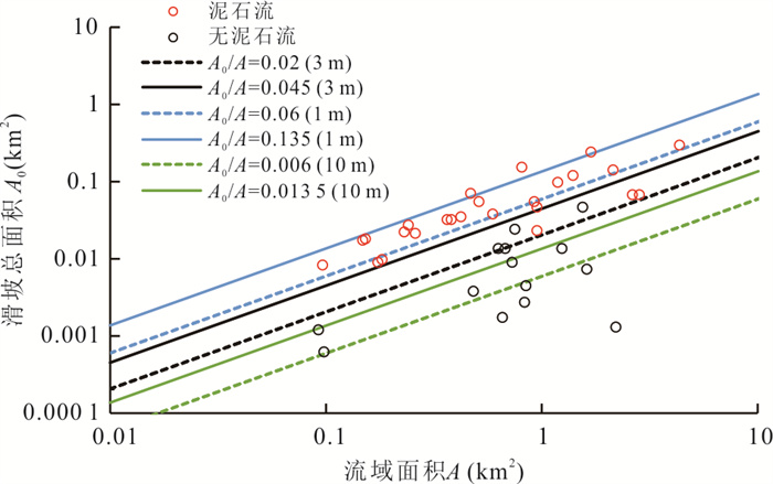
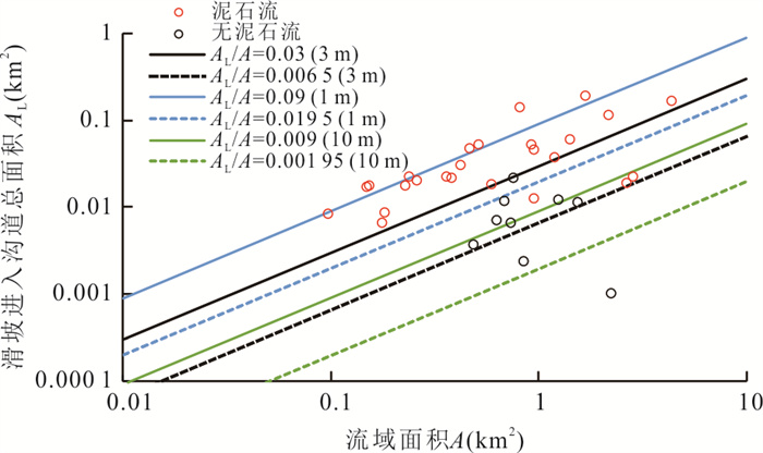
摘要: 流域内暴发大量浅层滑坡会导致沟谷型泥石流发生,但鲜有研究揭示滑坡物源量和沟谷泥石流形成条件.因此,基于泥石流的形成机理对这类型泥石流形成需要的滑坡物源条件进行评价,分析2010年福建顺昌元坑镇宝庄村沟谷型泥石流和浅层滑坡之间的关系,进而提出这类泥石流发生的物源条件模型.结果表明:流域内滑坡面积越大,土层厚度越大,则越有利于暴发浅层滑坡诱发的沟谷型泥石流.因此,可运用滑坡面积(A0)、流域面积(A)和土层厚度(h)划分某区域内沟谷泥石流的易发等级.对于华东区域的沟谷:流域的平均土层厚度为h时,当发生滑坡的总面积(A0)与流域的面积(A)关系为:A0/A≥0.045×(3/h),极容易暴发沟谷型泥石流;0.02×(3/h)≤A0/A≤0.045×(3/h),较容易暴发沟谷型泥石流;0.02×(3/h)≥A0/A,不容易暴发沟谷型泥石流.当进入沟道的滑坡总面积(AL)与流域的面积(A)的关系为:AL/A≥0.03×(3/h),极容易暴发沟谷型泥石流;0.006 5×(3/h)≤AL/A≤0.03×(3/h),较容易暴发沟谷型泥石流;0.006 5×(3/h)≥AL/A,不容易暴发沟谷型泥石流.所提出的模型适用于分析福建省浅层滑坡诱发的沟谷型泥石流形成机理.模型简单,输入所需的数据是易于测量的流域面积和流域内的浅层滑坡面积.该方法可根据新的局部条件对阈值参数进行调整,可用于其他地区浅层滑坡诱发的沟谷型泥石流案例分析.Abstract: Few studies pay attention to revealing the relationship between the amount of landslide material and the formation of gully debris flow, although a large number of shallow landslides in a watershed can lead to gully-type debris. Thus, the landslide source conditions required for the formation of this type of debris flow are evaluated based on the mechanism of debris flow formation. To analyze the relationship between the debris flow by shallow landslides in Baozhuang Village, Fujian, in 2010. And the material model of gully-type debris flow by shallow landslides was proposed. The result shows that the larger the landslides area in the catchment, the greater the possibility of gully-type debris flow. The landslide area (A0), catchment area (A) and soil thickness (h) can be applied to classify the susceptibility class of gully-type debris flow by shallow landslides. For the gullies in the East China region: when the average soil thickness of the catchment is h (m), the total of area where landslides occur (A0) is related to the area of the catchment (A) as: it is very high probabilities of debris flow formation when A0/A≥0.045×(3/h). The probabilities of debris flow formation is medium when 0.02×(3/h)≤A0/A≤0.045×(3/h). The probabilities of debris flow formation is very low when 0.02×(3/h)≥A0/A. When the total area of landslides entering the channel (AL) is related to the area of the catchment (A) as: it is very high probabilities of debris flow formation when AL/A≥0.03×(3/h). The probabilities of debris flow formation is medium when 0.006 5×(3/h)≤AL/A≤0.03×(3/h). The probabilities of debris flow formation is very low when 0.006 5×(3/h)≥AL/A. The empirical models are simple, and the data needed necessary for the input are easily measurable catchment areas and landslides area. The approach may be applied to the analysis debris flow by shallow landslides in other areas due to simplicity, when adapting the threshold parameters according to new local conditions.
-
Key words:
- shallow landslides /
- debris flow /
- statistical model /
- threshold /
- engineering geology
-
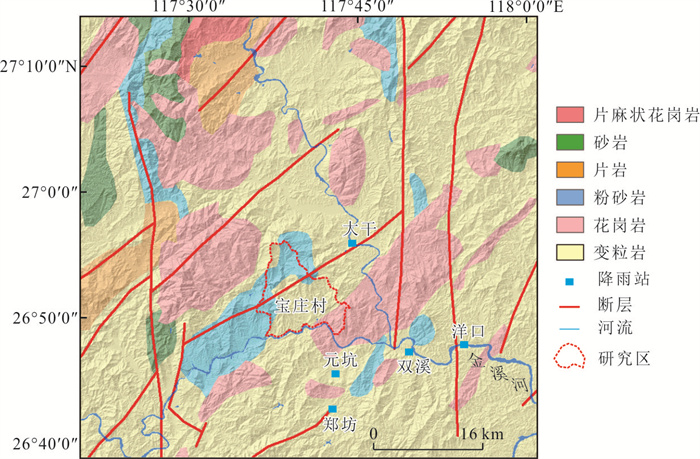
图 1 研究区地理位置及地质环境特征
Fig. 1. Geographical location and geological environment characteristics of the study area
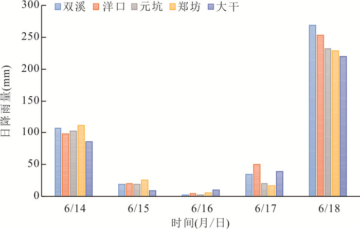
图 2 双溪、洋口、元坑、郑坊、大干镇气象站日降雨量
站点位置分布图 1所示.2010年6月14日至6月18日,顺昌县
Fig. 2. Distribution of daily rainfall in Shuangxi, Yangkou, Yuankeng, Zhengfang and Dagan towns
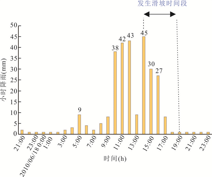
图 3 顺昌县元坑镇“6·18”小时降雨分布
Fig. 3. Hourly rainfall distribution of Yuankeng Town, Shunchang county from June 18th, 2010
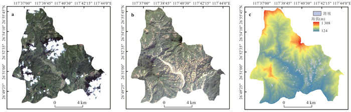
图 4 研究区遥感影像
a.灾前遥感影像(2009年9月);b.灾后遥感影像(2014年3月)c.研究区滑坡空间分布(裁剪范围是图 1中研究区范围)
Fig. 4. Remote sensing image of the study area
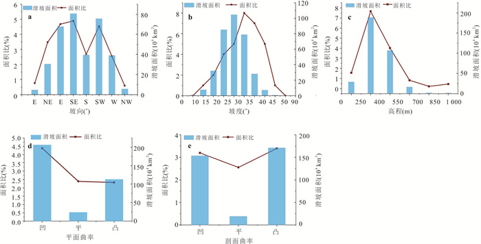
图 5 滑坡刮痕面积、滑坡刮痕面积百分比(LASP)与坡向、坡度、高程、平面曲率、剖面曲率的关系
Fig. 5. Relationship between landslide scar area, landslide scar area percentage (LASP) and slope aspect, slope angle, elevation, plane curvature, profile curvature

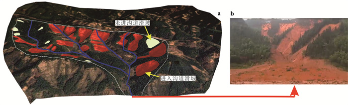
图 7 遥感解译示意
AL为所有标红滑坡的面积总和,对应的总体积为VSL;A0为所有滑坡面积总和,对应的总体积为VS0
Fig. 7. Remote sensing interpretation diagram
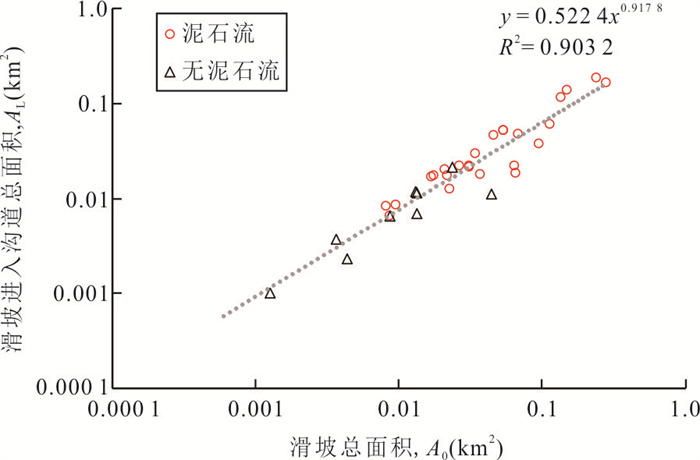
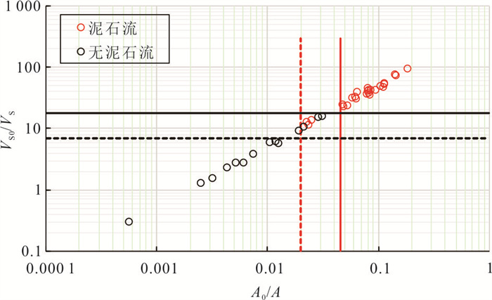
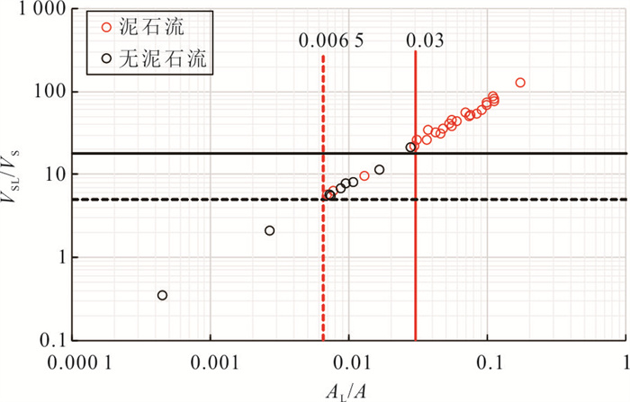
图 8 流域内滑坡总面积(A0)和直接进入沟道的滑坡总面积(AL)的关系
Fig. 8. Relationship between the total area of landslides in the catchment (A0) and the total area of landslides directly into the channel (AL)
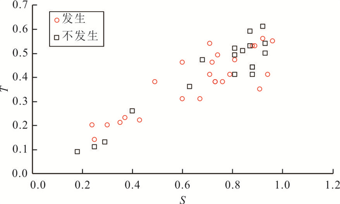
图 9 S-T关系图
Fig. 9. Relationship between the T-factor and the area percentage (S) of slopes between 25° to 45°
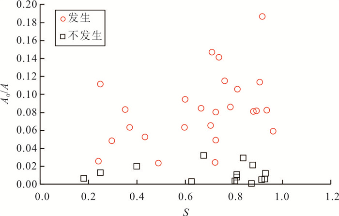
图 10 S和A0/A的关系图
Fig. 10. Relationship between the A0/A and the area percentage (expressed as ratio S) of slopes between 25° to 45°
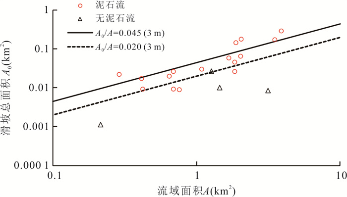
图 15 A0-A关系图(聂都乡)
Fig. 15. A0-A thresholds associated with debris flow catchment in Niedu township
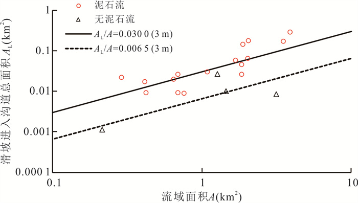
图 16 AL-A关系图(聂都乡)
Fig. 16. AL-A thresholds associated with debris flow catchment in Niedu township
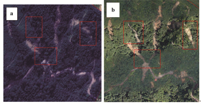
图 17 谷歌卫星图像和无人机图像对比分析
a.谷歌图像;b.无人机航拍图像
Fig. 17. Comparative analysis of Google satellite image and UAV image
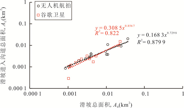
图 18 谷歌图像和无人机图像A0和AL对比分析
Fig. 18. Google images and UAV images A0 and AL comparison analysis
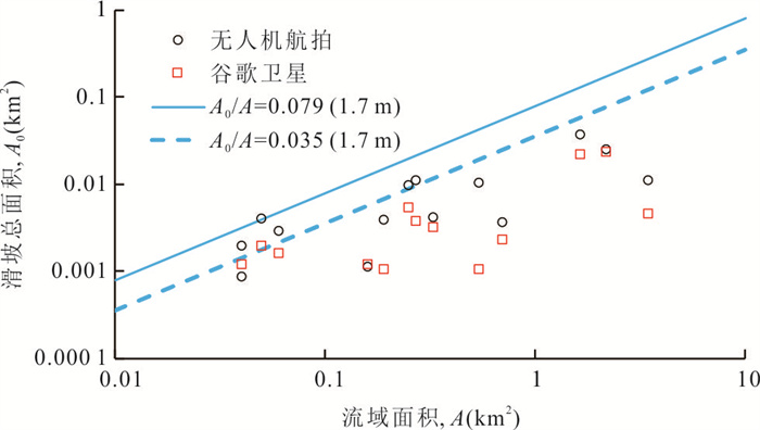
图 19 A0-A关系图(三明市)
Fig. 19. A0-A thresholds associated with debris flow catchment in Sanming
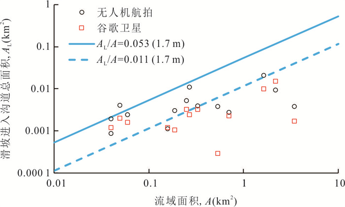
图 20 AL-A关系图(三明市)
Fig. 20. AL-A thresholds associated with debris flow catchment in Sanming
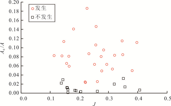
图 21 纵比降和滑坡的关系
Fig. 21. The relationship between the stream channel gradient and the A0/A
表 1 泥石流地形、降雨条件情况统计
Table 1. Statistics of debris flow topography and rainfall conditions
编号 A S J T 是否发生泥石流(野外调查) 1 1.41 0.89 0.14 0.53 是 2 0.15 0.76 0.35 0.38 是 3 0.26 0.73 0.27 0.38 是 4 0.10 0.67 0.35 0.31 是 5 0.38 0.35 0.32 0.21 是 6 0.59 0.37 0.29 0.23 是 7 0.24 0.25 0.40 0.14 是 8 2.66 0.24 0.26 0.20 是 9 0.18 0.73 0.38 0.38 是 10 2.16 0.60 0.25 0.46 是 11 0.47 0.71 0.26 0.41 是 12 2.84 0.49 0.22 0.38 是 13 0.81 0.92 0.23 0.56 是 14 1.19 0.88 0.16 0.53 是 15 0.42 0.94 0.11 0.41 是 16 0.15 0.91 0.15 0.35 是 17 0.96 0.72 0.22 0.46 是 18 1.69 0.74 0.18 0.49 是 19 0.96 0.30 0.28 0.20 是 20 0.18 0.43 0.31 0.22 是 21 0.36 0.79 0.23 0.41 是 22 0.93 0.96 0.17 0.55 是 23 0.23 0.60 0.28 0.31 是 24 0.51 0.81 0.26 0.47 是 25 4.38 0.71 0.16 0.54 是 26 2.23 0.87 0.16 0.59 否 27 0.85 0.93 0.18 0.54 否 28 0.68 0.40 0.32 0.26 否 29 0.75 0.68 0.35 0.47 否 30 0.74 0.93 0.16 0.50 否 31 0.33 0.88 0.16 0.41 否 32 1.62 0.92 0.19 0.61 否 33 0.09 0.25 0.36 0.11 否 34 0.10 0.18 0.41 0.09 否 35 0.07 0.29 0.40 0.13 否 36 1.55 0.84 0.14 0.51 否 37 0.66 0.63 0.20 0.36 否 38 0.49 0.81 0.16 0.41 否 39 1.25 0.81 0.16 0.49 否 40 0.56 0.88 0.14 0.44 否 41 0.63 0.88 0.14 0.44 否 42 1.40 0.87 0.15 0.53 否 43 0.83 0.81 0.26 0.52 否 注:表 1编号和表 2编号对应.  下载: 导出CSV
表 2 “6·18”宝庄村调查沟道发生泥石流时的最低泥沙含量
Table 2. Minimum sand content required for debris flow to occur in Baozhuang village of "6·18"
编号 A0(m2) VS0(m3) AL(m2) VSL(m3) VS(m3) 1 114 796.0 43 048.5 59 590.0 44 692.5 1 420.2 2 17 469.0 6 550.9 17 196.0 12 897.0 169.9 3 20 798.0 7 799.3 19 838.0 14 878.5 290.4 4 8 172.0 3 064.5 8 172.0 6 129.0 116.8 5 31 322.0 11 745.8 21 066.0 15 799.5 417.7 6 37 189.0 13 945.9 17 854.0 13 390.5 621.1 7 26 735.0 10 025.6 22 256.0 16 692.0 284.4 8 66 106.0 24 789.8 18 611.0 13 958.3 2 485.8 9 8 604.0 32 26.5 6 532.0 4 899.0 193.1 10 134 921.0 50 595.4 114 719.0 86 039.3 2 143.1 11 68 760.0 25 785.0 47 318.0 35 488.5 488.0 12 64 343.0 24 128.6 22 161.0 16 620.8 2 633.2 13 150 469.0 56 425.9 140 209.0 105 156.8 829.8 14 95 939.0 35 977.1 37 056.0 27 792.0 1 077.4 15 34 562.0 12 960.8 29 762.0 22 321.5 413.5 16 16 936.0 6 351.0 16 936.0 12 702.0 156.8 17 22 532.0 8 449.5 12 348.0 9 261.0 996.3 18 238 105.0 89 289.4 188 396.0 141 297.0 1 633.6 19 45 923.0 17 221.1 45 923.0 34 442.3 968.2 20 9 594.0 3 597.8 8 462.0 6 346.5 208.5 21 31 176.0 11 691.0 21 894.0 16 420.5 379.8 22 54 337.0 20 376.4 51 509.0 38 631.8 877.3 23 21 707.0 8 140.1 17 185.0 12 888.8 263.9 24 53 931.0 202 24.1 51 497.0 38 622.8 568.5 25 283 646.0 106 367.3 166 119.0 124 589.3 3 724.4 26 1 255.0 470.6 1 008.0 756.0 2 121.0 27 4 392.0 1 647.0 2 300.0 1 725.0 829.8 28 13 290.0 4 983.8 11 381.0 8 535.8 745.7 29 23 616.0 8 856.0 21 369.0 16 026.8 757.3 30 8 740.0 3 277.5 6 489.0 4 866.8 725.9 31 0 0 0 0 341.4 32 7 011.0 2 629.1 0 0 1 561.0 33 1 181.0 442.9 0 0 105.2 34 601.0 225.4 0 0 110.3 35 0 0 0 0 74.3 36 44 431.0 16 661.6 11 269.0 8 451.8 1 485.3 37 1 672.0 627.0 0.0 0.0 677.1 38 3 653.0 1 369.9 3 653.0 2 739.8 487.6 39 13 175.0 4 940.6 11 921.0 8 940.8 1 131.9 40 0 0 0 0 536.8 41 13 327.0 4 997.6 6 854.0 5 140.5 640.3 42 0 0 0 0 1 288.1 43 2 668.0 1 000.5 0 0 879.6 注:表 1编号和表 2编号对应.
下载: 导出CSV
-
Adeline, K. R. M., Chen, M., Briottet, X., et al., 2013. Shadow Detection in Very High Spatial Resolution Aerial Images: A Comparative Study. ISPRS Journal of Photogrammetry and Remote Sensing, 80: 21-38. https://doi.org/10.1016/j.isprsjprs.2013.02.003 Bordoni, M., Galanti, Y., Bartelletti, C., et al., 2020. The Influence of the Inventory on the Determination of the Rainfall-Induced Shallow Landslides Susceptibility Using Generalized Additive Models. Catena, 193: 104630. https://doi.org/10.1016/j.catena.2020.104630. Bai, H. L., Feng, W. K., Yi, X. Y., et al., 2021. Group-Occurring Landslides and Debris Flows Caused by the Continuous Heavy Rainfall in June 2019 in Mibei Village, Longchuan County, Guangdong Province, China. Natural Hazards, 108(3): 3181-3201. https://doi.org/10.1007/s11069-021-04819-1 Chiang, S. H., Chang, K. T., Mondini, A. C., et al., 2012. Simulation of Event-Based Landslides and Debris Flows at Watershed Level. Geomorphology, 138(1): 306-318. https://doi.org/10.1016/j.geomorph.2011.09.016 Chen, X. L., Jiang, K., 2021. Modeling Method of Concurrent Emergency Chain Based on Bayesian Network. Chinese Journal of Management Science, 29(10): 165-177(in Chinese with English abstract). Cui, P., Guo, J., 2021. Evolution Models, Risk Prevention and Control Countermeasures of the Valley Disaster Chain. Advanced Engineering Sciences, 53(3): 5-18(in Chinese with English abstract). Cannon, S. H., Gartner, J. E., Rupert, M. G., et al., 2010. Predicting the Probability and Volume of Postwildfire Debris Flows in the Intermountain Western United States. GSA Bulletin, 122(1-2): 127-144. https://doi.org/10.1130/b26459.1 Dahlquist, M. P., West, A. J., 2019. Initiation and Runout of Post-Seismic Debris Flows: Insights from the 2015 Gorkha Earthquake. Geophysical Research Letters, 46(16): 9658-9668. https://doi.org/10.1029/2019GL083548 Dou, J., Paudel, U., Oguchi, T., et al., 2015. Shallow and Deep-Seated Landslide Differentiation Using Support Vector Machines: A Case Study of the Chuetsu Area, Japan. Terrestrial, Atmospheric and Oceanic Sciences, 26: 227. https://doi.org/10.3319/tao.2014.12.02.07 (eosi)Fan, L. F., Lehmann, P., McArdell, B., et al., 2017. Linking Rainfall-Induced Landslides with Debris Flows Runout Patterns towards Catchment Scale Hazard Assessment. Geomorphology, 280: 1-15. https://doi.org/10.1016/j.geomorph.2016.10.007 Guo, C. B., Wu, R. A., Zhong, N., et al., 2024. Large Landslides along Active Tectonic Zones of Eastern Tibetan Plateau: Background and Mechanism of Landslide Formation. Earth Science, 49(12): 4635-4658. (in Chinese with English abstract). Huang, X. H., Guo, F., Deng, M. L., et al., 2020. Understanding the Deformation Mechanism and Threshold Reservoir Level of the Floating Weight-Reducing Landslide in the Three Gorges Reservoir Area, China. Landslides, 17(12): 2879-2894. https://doi.org/10.1007/s10346-020-01435-1 Hürlimann, M., Abancó, C., Moya, J., et al., 2014. Results and Experiences Gathered at the Rebaixader Debris-Flow Monitoring Site, Central Pyrenees, Spain. Landslides, 11(6): 939-953. https://doi.org/10.1007/s10346-013-0452-y Iverson, R. M., Reid, M. E., Lahusen, R. G., 1997. Debris-Flow Mobilization from Landslides. Annual Review of Earth and Planetary Sciences, 25: 85. https://doi.org/10.1146/annurev.earth.25.1.85 Jakob, M., 2000. The Impacts of Logging on Landslide Activity at Clayoquot Sound, British Columbia. Catena, 38(4): 279-300. https://doi.org/10.1016/s0341-8162(99)00078-8 Lan, H. X., Zhou, C. H., Wang, L. J., et al., 2004. Landslide Hazard Spatial Analysis and Prediction Using GIS in the Xiaojiang Watershed, Yunnan, China. Engineering Geology, 76(1-2): 109-128. https://doi.org/10.1016/j.enggeo.2004.06.009 Li, Y. W., Xu, L. R., Zhang, L. L., et al., 2023. Study on Development Patterns and Susceptibility Evaluation of Coseismic Landslides within Mountainous Regions Influenced by Strong Earthquakes. Earth Science, 48(5): 1960-1976(in Chinese with English abstract). Li, Z. H., Zhang, C. L., Chen, B., et al., 2022. A Technical Framework of Landslide Prevention Based on Multi-Source Remote Sensing and Its Engineering Application. Earth Science, 47(6): 1901-1916(in Chinese with English abstract). Liu, C. N., Dong, J. J., Peng, Y. F., et al., 2009. Effects of Strong Ground Motion on the Susceptibility of Gully Type Debris Flows. Engineering Geology, 104(3-4): 241-253. https://doi.org/10.1016/j.enggeo.2008.10.012 Liang, Z., Wang, C. M., Ma, D. H., et al., 2021. Exploring the Potential Relationship between the Occurrence of Debris Flow and Landslides. Natural Hazards and Earth System Sciences, 21(4): 1247-1262. https://doi.org/10.5194/nhess-21-1247-2021 Pradhan, A. M. S., Lee, S. R., Kim, Y. T., 2019. A Shallow Slide Prediction Model Combining Rainfall Threshold Warnings and Shallow Slide Susceptibility in Busan, Korea. Landslides, 16(3): 647-659. https://doi.org/10.1007/s10346-018-1112-z Pu, L. M., Zhang, S. W., Wang, R. H. et al., 2016. Analysis of Erosion Gully Information Extraction Based on Multi-Resource Remote Sensing Images. Geography and Geo-Information Science, 32(1): 90-94(in Chinese with English abstract). Qi, S., Zhang, Y. L., Zhang, P., et al., 2014. An Assessment Index System for Landslide Risk in Bailong River Basin. Journal of Yangtze River Scientific Research Institute, 31(1): 23-28 (in Chinese with English abstract). Qiu, Q. C., Zheng, Q. M., Zhang, N. S., 2010. Meteorological Condition Analysis for the Extraordinarily Geological Hazard in Shunchang, Fujian Province. Geology of Fujian, 29(Suppl. 1): 92-97(in Chinese with English abstract). Roering, J. J., Schmidt, K. M., Stock, J. D., et al., 2003. Shallow Landsliding, Root Reinforcement, and the Spatial Distribution of Trees in the Oregon Coast Range. Canadian Geotechnical Journal, 40(2): 237-253. https://doi.org/10.1139/t02-113 Tang, C., Zhu, J., Chang, M., et al., 2012. An Empirical-Statistical Model for Predicting Debris-Flow Runout Zones in the Wenchuan Earthquake Area. Quaternary International, 250: 63-73. https://doi.org/10.1016/j.quaint.2010.11.020 van Den Eeckhaut, M., Moeyersons, J., Nyssen, J., et al., 2009. Spatial Patterns of Old, Deep-Seated Landslides: A Case-Study in the Northern Ethiopian Highlands. Geomorphology, 105(3-4): 239-252. https://doi.org/10.1016/j.geomorph.2008.09.027 Vandromme, R., Thiery, Y., Bernardie, S., et al., 2020. ALICE (Assessment of Landslides Induced by Climatic Events): A Single Tool to Integrate Shallow and Deep Landslides for Susceptibility and Hazard Assessment. Geomorphology, 367: 107307. https://doi.org/10.1016/j.geomorph.2020.107307 Wang, Y. M., Yin, K. L., 2018. Initiating Mechanism of Typhoon-Triggered Debris Flow. Earth Science, 43(Suppl. 2): 263-270(in Chinese with English abstract). Wei, D. G., Jie, Y. J., Huang, T. G., 1997. Regional Geological Structure of Fujian. Regional Geology of China, 16(2): 162-170(in Chinese with English abstract). Xia, M. X., Li, Y. Y., Wu, J. M., et al., 2021. Research on Rainfall Early Warning Threshold of Landslide Disaster in Zhangjiajie City Based on 1-D Statistical Model. Journal of Natural Disasters, 30(4): 203-212. https://doi.org/10.13577/j.jnd.2021.0422 Yang, H. J., Yang, T. Q., Zhang, S. J., et al., 2020. Rainfall-Induced Landslides and Debris Flows in Mengdong Town, Yunnan Province, China. Landslides, 17(4): 931-941. https://doi.org/10.1007/s10346-019-01336-y Ye, X. Q., 2018. Planting Performance and High-Yielding Cultivation Techniques of Y Liangyou 8199 in Shunchang County. Fujian Science and Technology of Rice and Wheat, 36(1): 37-39 in Chinese with English abstract. Yu, B., Wang, T., Zhu, Y., et al., 2016. Topographical and Rainfall Factors Determining the Formation of Gully-Type Debris Flows Caused by Shallow Landslides in the Dayi Area, Guizhou Province, China. Environmental Earth Sciences, 75(7): 551. https://doi.org/10.1007/s12665-016-5243-z Zhang, Q. K., Ling, S. X., Li, X. N., et al., 2020. Comparison of Landslide Susceptibility Mapping Rapid Assessment Models in Jiuzhaigou County, Sichuan Province, China. Chinese Journal of Rock Mechanics and Engineering, 39(8): 1595-1610 (in Chinese with English abstract). Zhou, B. F., Lee, D. J., Luo, D. F., et al., 1991. A Guide for Debris-Flows Hazard Mitigation. Science Press, Beijing (in Chinese). Zhou, W., Tang, C., Van Asch, T. W. J., et al., 2016. A Rapid Method to Identify the Potential of Debris Flow Development Induced by Rainfall in the Catchments of the Wenchuan Earthquake Area. Landslides, 13(5): 1243-1259. https://doi.org/10.1007/s10346-015-0631-0 陈雪龙, 姜坤, 2021. 基于贝叶斯网络的并发型突发事件链建模方法. 中国管理科学, 29(10): 165-177. 崔鹏, 郭剑, 2021. 沟谷灾害链演化模式与风险防控对策. 工程科学与技术, 53(3): 5-18. 郭长宝, 吴瑞安, 钟宁, 等, 2024. 青藏高原东部活动构造带大型滑坡成灾背景与灾变机制. 地球科学, 49(12): 4635-4658. 李永威, 徐林荣, 张亮亮, 等, 2023. 强震山区地震诱发滑坡发育规律与易发性评估. 地球科学, 48(5): 1960-1976. 李振洪, 张成龙, 陈博, 等, 2022. 一种基于多源遥感的滑坡防灾技术框架及其工程应用. 地球科学, 47(6): 1901-1916. 蒲罗曼, 张树文, 王让虎, 等, 2016. 多源遥感影像的侵蚀沟信息提取分析. 地理与地理信息科学, 32(1): 90-94. 齐识, 张雅莉, 张鹏, 等, 2014. 白龙江流域滑坡危险性评价指标体系的构建. 长江科学院院报, 31(1): 23-28. 邱泉成, 郑清明, 张能胜, 2010. 福建顺昌特大地质灾害气象条件分析. 福建地质, 29(增刊1): 92-97. 王一鸣, 殷坤龙, 2018. 台风暴雨型泥石流启动机制. 地球科学, 43(增刊2): 263-270. 韦德光, 揭育金, 黄廷淦, 1997. 福建省区域地质构造特征. 中国区域地质, 16(2): 162-170. 叶喜琴, 2018. Y两优8199在顺昌县种植表现与高产栽培技术. 福建稻麦科技, 36(1): 37-39. 张玘恺, 凌斯祥, 李晓宁, 等, 2020. 九寨沟县滑坡灾害易发性快速评估模型对比研究. 岩石力学与工程学报, 39(8): 1595-1610. 周必凡, 李德基, 罗德富, 等, 1991. 泥石流防治指南. 北京: 科学出版社. -

 点击查看大图
计量
- 文章访问数: 10
- HTML全文浏览量: 5
- PDF下载量: 3
- 被引次数: 0
