


Quantitative Representation and Influencing Factors to Landscape Maturity of Danxia Landscape: A Case Study in Mount Danxiashan, Guangdong Province
-
摘要: 地貌发育的定量化研究对于深化丹霞地貌的基础研究和多学科融合具有重要意义,而地貌指数可以用于评估区域构造活动及地貌演化,定量指示地貌发育程度,有助于理解丹霞地貌的发育过程及控制因素. 因此,以广东丹霞山世界地质公园为研究区,基于TecDEM工具箱移动窗口方法选择窗口大小并计算面积高程积分(HI)、地表粗糙度(SR)和地表指数(SI)这3种地貌指数. 丹霞山移动窗口边长可选择900 m,由此计算的丹霞组HI集中于0.22~0.47,SR和SI分别集中在1.05~1.14和-0.37~-0.11,SR和SI呈显著的负相关,且高SR和低SI多在赤壁丹崖景观一带分布,表明丹霞山的地貌发育程度整体较高,与学者定义的丹霞山地貌发育阶段相符. 分析地貌指数与断裂、地层和河流的定量关系可知:HI值及SR值随着与断裂两侧距离的增大而逐渐下降;锦石岩段的HI值集中于0.29~0.48,在丹霞组中最高,巴寨段及白寨顶段较低;河流两侧的白寨顶段显示出较高的HI值(> 0.24),而巴寨段具有较低的HI值,显示其在构造分布和河流的共同作用下呈现较明显的侧蚀.Abstract: Quantitative research of geomorphic evolution is of great significance to further study the theorical research and multi-disciplinary integration of Danxia landscape. Geomorphic indices, which play an important role on evaluating regional tectonic activity and geomorphic evolution as well as quantitatively indicating landscape maturity, are advantageous to understand the evolution process and controlling factors of Danxia landscape. Therefore, in this study, the Mount Danxiashan, located in Shaoguan, Guangdong Province, was taken as study area, and suitable moving window sizes as well as three geomorphic which are Hypsometric Integral (HI), Surface Roughness (SR) and Surface Index (SI) were calculated based on the open-source TecDEM toolbox. The 900 meters was chosen as moving window size for calculating geomorphic indices. The HI values distribution of Danxia Formation concentrates in 0.22 to 0.47, as well as the ones of SR values and SI values concentrate in 1.04 to 1.14 and -0.37 to -0.11, respectively. There is an apparent negative correlation between SR values and SI values, and high SR values with low SI values usually distribute around Danxia redcliff landscape. The relatively high landscape maturity indicated by this study is compatible with scholars' views about the evolution stage of Mount Danxiashan. The quantitative relation between geomorphic indices and fault activities, lithology and fluvial erosion shows that HI and SR values decrease with the increasing distance from faults. The HI values of Jinshiyan Member concentrates in 0.29to 0.48, which is the highest of ones in Danxia Formation, in contrast to relatively low values of Bazhai Member and Baizhaiding Member. Moreover, the relatively high HI values (> 0.24) appears in Baizhaiding Member while the relatively low HI values appears in Bazhai Member located on sides of stream, indicating distinct lateral erosion with the combined action of tectonic condition and fluvial process.
-
Key words:
- Danxia landscape /
- TecDEM toolbox /
- moving window /
- geomorphic indices /
- quantitative research /
- geomorthology
-
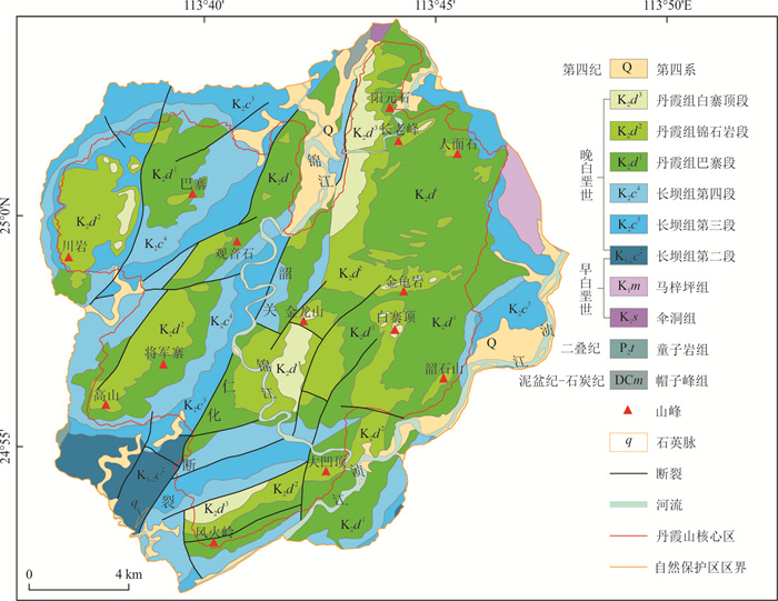
图 1 丹霞山世界地质公园区域地质简图
广东省地质局2000年绘制. 参考张显球(1992)和Chen et al.,(2022)修改
Fig. 1. Brief geological map of Danxiashan UGGp
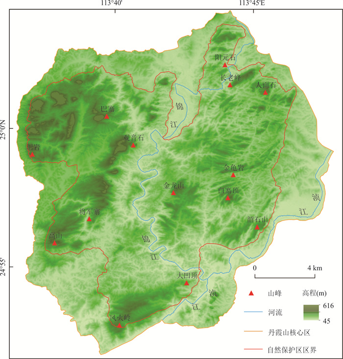
图 2 丹霞山区域地表高程分布
AW3D30,下载自JAXA的ALOS全球数字地表模型平台(
https://www.eorc.jaxa.jp/ALOS/en/dataset/aw3d30/aw3d30_e.htm )Fig. 2. Elevation distribution of Danxiashan UGGp
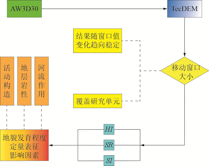
图 3 丹霞山地貌发育程度定量指示技术路线图
Fig. 3. Technology roadmap of quantitative representation to landscape maturity of Mount Danxiashan
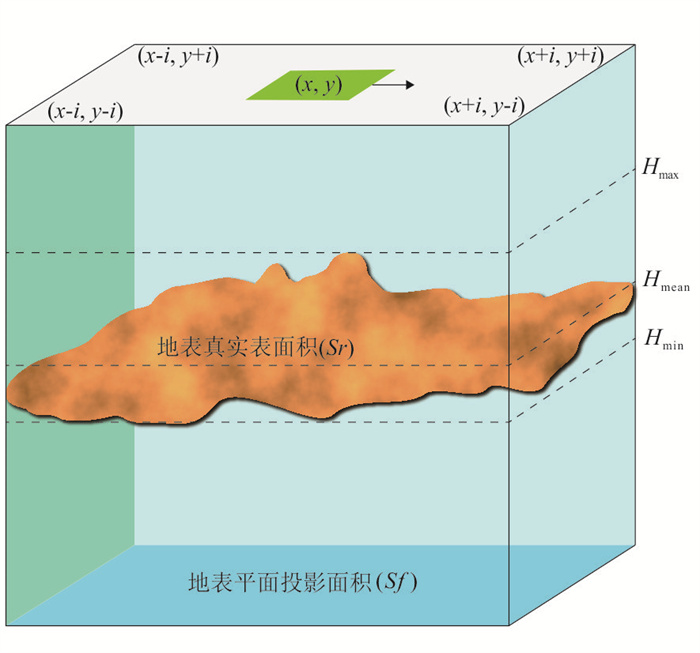
图 4 TecDEM移动窗口计算原理
参考Andreani et al.(2014)和Obaid and Allen(2017)修改
Fig. 4. Calculation principle of moving window in TecDEM
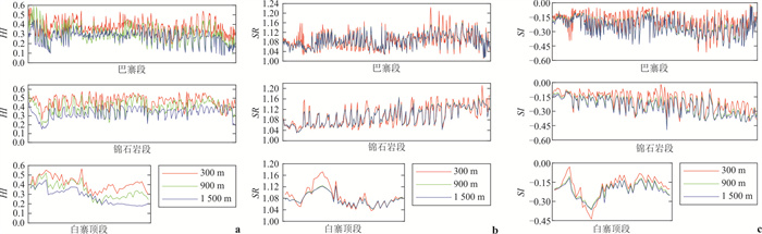
图 5 基于300 m、900 m、1 500 m移动窗口计算的丹霞组HI(a)、SR(b)和SI(c)指数结果
Fig. 5. HI(a), SR(b) and SI(c) values of Danxia Formation based on moving window with the size of 300 m, 900 m and 1 500 m
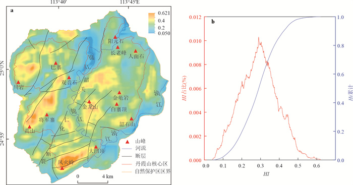
图 6 丹霞山HI计算结果图(a)及HI值分布图(b)
Fig. 6. HI value map (a) and distribution (b) of Mount Danxiashan
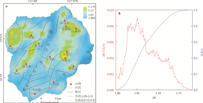
图 7 丹霞山SR计算结果图(a)及SR值分布图(b)
Fig. 7. SR value map (a) and distribution (b) of Mount Danxiashan
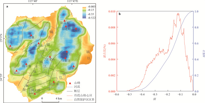
图 8 丹霞山SI计算结果图(a)及SI值分布图(b)
Fig. 8. SI value map (a) and distribution (b) of Mount Danxiashan
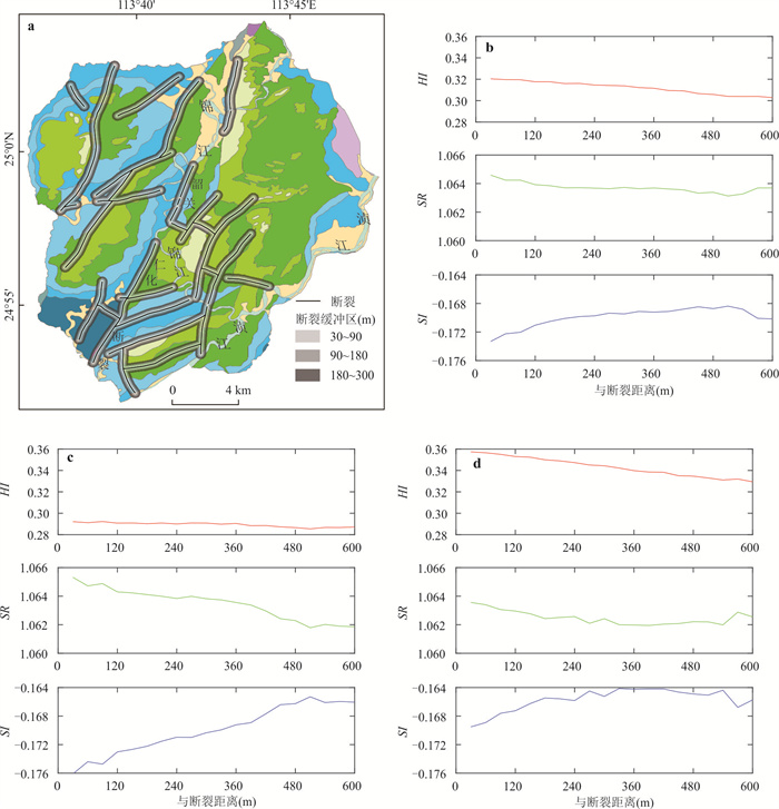
图 9 丹霞山主要断裂多重环形缓冲区及其地貌指数提取结果
以300 m内缓冲区为例展示. 以韶关-仁化断裂为界,盆地西侧及东侧断裂缓冲区的地貌指数提取结果如c和d所示
Fig. 9. Geomorphic indices of multiple ring buffers of main faults in Mount Danxiashan
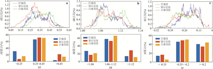
图 10 丹霞山HI(a)、SR(b)、SI(c)计算结果图和丹霞组HI值分布图
Fig. 10. HI (a), SR (b) and SI (c) values map of Mount Danxiashan and HI values distribution of Danxia Formation
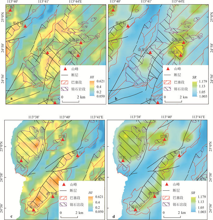
图 11 丹霞山局部区域HI和SR提取结果对比
Fig. 11. Comparison to HI and SR values of local area in Mount Danxiashan
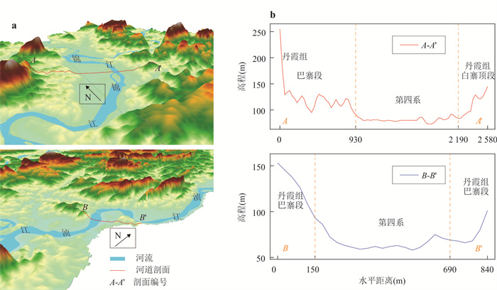
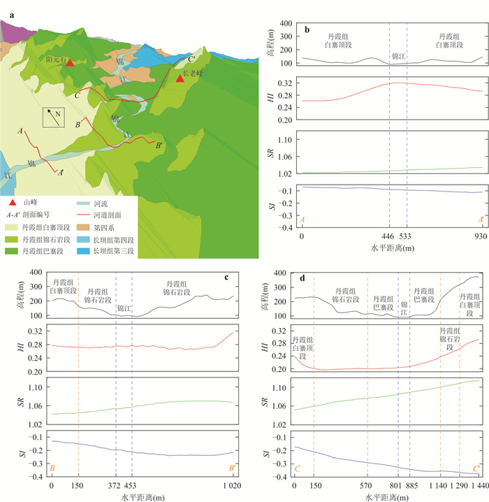
图 12 丹霞山流经第四系主要河流的沿岸地势
三维展示图纵向拉伸2倍以便于显示
Fig. 12. Terrain along main rivers which traverse quaternary system in Mount Danxiashan
-
Albani, A., Klinkenberg, A., Andison, . W., et al., 2004. The Choice of Window Size in Approximating Topographic Surfaces from Digital Elevation Models. International Journal of Geographical Information Science, 18(6): 577-593. https://doi.org/10.1080/13658810410001701987 Andreani, L., Stanek, K. P., Gloaguen, R., et al., 2014. DEM-Based Analysis of Interactions between Tectonics and Landscapes in the Ore Mountains and Eger Rift (East Germany and NW Czech Republic). Remote Sensing, 6(9): 7971-8001. https://doi.org/10.3390/rs6097971 Barbosa, N., Andreani, L., Gloaguen, R., et al., 2021. Window-Based Morphometric Indices as Predictive Variables for Landslide Susceptibility Models. Remote Sensing, 13(3): 451. https://doi.org/10.3390/rs13030451 Berti, M., Corsini, A., Daehne, A., 2013. Comparative Analysis of Surface Roughness Algorithms for the Identification of Active Landslides. Geomorphology, 182: 1-18. https://doi.org/10.1016/j.geomorph.2012.10.022 Chang, Z. Y., Wang, J., Bai, S. B., et al., 2015. Comparison of Hypsometric Integral Methods. Journal of Arid Land Resources and Environment, (3): 171-175 (in Chinese with English abstract). Chen, L. Q., Li, X. M., Guo, F. S., et al., 2018. Characteristics and Origin of Honeycombs in the DanxiashanGlobal Geopark in South China. Geological Review, 64(4): 895-904 (in Chinese with English abstract). Chen, L. Q., Li, P. C., Guo, F. S., et al., 2019. Facies Analysis and Paleoclimate Implications of the Late Cretaceous Danxia Formation in the Danxia Basin, Northern Guangdong Province, South China. Acta Sedimentologica Sinica, 37(1): 17-29 (in Chinese with English abstract). Chen, X., Chen, L. Q., Zhang, Y. H., et al., 2021. Lithological and Environmental Controls on Large Tafoni along Conglomerate Cliffs in Subtropic Humid Danxiashan UNESCO Global Geopark. Journal of Mountain Science, 18(5): 1131-1143. https://doi.org/10.1007/s11629-020-6649-3 Chen, L. Q., Guo, F. S., Shao, C. J., et al., 2022. Characteristics and Controlling Factors of Danxia Landscapes in Jiangxi Province. Acta Geologica Sinica, 96(11): 4023-4037 (in Chinese with English abstract). Chen, L. Q., Shi, Y. X., Ng, Y., et al., 2022. Roles of Algae in Honeycomb Weathering in Humid Climate: an Example from Danxiashan UNESCO Global Geopark of China. Geoheritage, 14(4): 120. https://doi.org/10.1007/s12371-022-00749-x Cohen, S., Willgoose, G., Hancock, G., 2008. A Methodology for Calculating the Spatial Distribution of the Area-Slope Equation and the Hypsometric Integral within a Catchment. Journal of Geophysical Research: Earth Surface, 113(F3): F03027. https://doi.org/10.1029/2007JF000820 Florinsky, I. V., Skrypitsyna, T. N., Luschikova, O. S., 2018. Comparative Accuracy of the AW3D30 DSM, ASTER GDEM, and SRTM1 DEM: a Case Study on the Zaoksky Testing Ground, Central European Russia. Remote Sensing Letters, 9(7): 706-714. https://doi.org/10.1080/2150704X.2018.1468098 Grohmann, C. H., Riccomini, C., Alves, F. M., 2007. SRTM-Based Morphotectonic Analysis of the Poços de Caldas Alkaline Massif, Southeastern Brazil. Computers & Geosciences, 33(1): 10-19. https://doi.org/10.1016/j.cageo.2006.05.002 Guo, F. S., Chen, L. Q., Yan, Z. B., et al., 2020. Definition, Classification, and Danxianization of Danxia Landscapes. Acta Geologica Sinica, 94(2): 361-374 (in Chinese with English abstract). Hu, Z. H., Peng, J. W., Hou, Y. L., et al., 2017. Evaluation of Recently Released Open Global Digital Elevation Models of Hubei, China. Remote Sens, 9: 262. https://doi.org/10.3390/rs9030262 Huang, R. H., 1996. Trend Surface Analysis for Danxia Landform in the Danxia Basin. Acta Scientiarum Naturalium Universitatis Sunyatseni, 35(S1): 100-105(in Chinese with English abstract). Li, H., Zhao, J. Y., 2018. Evaluation of the Newly Released Worldwide AW3D30 DEM over Typical Landforms of China Using Two Global DEMs and ICESat/GLAS Data. IEEE Journal of Selected Topics in Applied Earth Observations and Remote Sensing, 11(11): 4430-4440. https://doi.org/10.1109/JSTARS.2018.2874361 Li, Z. C., Wang, X. Y., Yu, Y., et al., 2021. The Impacts of Base Level and Lithology on Fluvial Geomorphic Evolution at the Tectonically Active Laohu and Hasi Mountains, Northeastern Tibetan Plateau. Science China Earth Sciences, 64(6): 906-919 (in Chinese with English abstract). doi: 10.1007/s11430-020-9743-1 Liu, X., Guo, F. S., Chen, L. Q., et al., 2019. Lithologic Control on the Development of Danxia Landscapes in Red Basins. Mountain Research, (2), 214-221 (in Chinese with English abstract). Luo, D. Y., Wen, X. P., Shen, P., et al., 2017. Information on Extraction of River Networks and Determination of Drainage Area Threshold Using DEM Data. Bulletion of Soil and Water Conservation, 37(4): 189-193 (in Chinese with English abstract). Nikolakopoulos, K. G., 2020. Accuracy Assessment of ALOS AW3D30 DSM and Comparison to ALOS PRISM DSM Created with Classical Photogrammetric Techniques. European Journal of Remote Sensing, 53(Sup2): 39-52. https://doi.org/10.1080/22797254.2020.1774424 Obaid, A. K., Allen, M. B., 2017. Landscape Maturity, Fold Growth Sequence and Structural Style in the Kirkuk Embayment of the Zagros, Northern Iraq. Tectonophysics, 717: 27-40. https://doi.org/10.1016/j.tecto.2017.07.006 Pei, Y. Q., Qiu, H. J., Hu, S., et al., 2021. Appraisal of Tectonic-Geomorphic Features in the Hindu Kush-Himalayas. Earth and Space Science, 8(5): e2020EA001386. https://doi.org/10.1029/2020EA001386 Peng, H., Pan, Z. X., Yan, L. B., et al., 2013. A Review of the Research on Red Beds and Danxia Landform. Acta GeographicaSinica, 68(9): 1170-1181(in Chinese with English abstract). Qi, D. L., Chen, Z. J., Wang, S. J., et al., 2015. Stratigraphic Classification, Evolution Stage and Geomorphologic Age of Kongtongshan Danxia Landform in Pingliang, Gansu, China. Mountain Research, (4): 408-415 (in Chinese with English abstract). Schanz, S. A., Montgomery, D. R., 2016. Lithologic Controls on Valley Width and Strath Terrace Formation. Geomorphology, 258: 58-68. https://doi.org/10.1016/j.geomorph.2016.01.015 Shahzad, F., Gloaguen, R., 2011. TecDEM: a MATLAB Based Toolbox for Tectonic Geomorphology, Part 2: Surface Dynamics and Basin Analysis. Computers & Geosciences, 37(2): 261-271. https://doi.org/10.1016/j.cageo.2010.06.009 Shen, P. F., 2014. The Evolution Mirrored by the Cretaceous Sedimentary Sequences in the Nanxiong-Danxia Basin and its Response to the Tectonic Transition at the SCS's Area(Dissertation). China University of Geosciences, Beijing (in Chinese with English abstract). Sofia, G., Dalla Fontana, G., Tarolli, P., 2014. High-Resolution Topography and Anthropogenic Feature Extraction: Testing Geomorphometric Parameters in Floodplains. Hydrological Processes, 28(4): 2046-2061. https://doi.org/10.1002/hyp.9727 Strahler, A. N., 1952. Hypsometric (Area-Altitude) Analysis of Erosional Topography. Geological Society of America Bulletin, 63: 1117-1142. https://doi.org/10.1130/0016-7606(1952)63[1117: HAAOET]2.0.CO;2 doi: 10.1130/0016-7606(1952)63[1117:HAAOET]2.0.CO;2 Tarolli, P., Sofia, G., Dalla Fontana, G., 2012. Geomorphic Features Extraction from High-Resolution Topography: Landslide Crowns and Bank Erosion. Natural Hazards, 61(1): 65-83. https://doi.org/10.1007/s11069-010-9695-2 Wang, D., Dong, Y. P., Jiao, Q. Q., et al., 2022. The Mechanism of Tectonic Deformation of the Central Yunnan Terrane in the Late Cenozoic Based on Tectonic Geomorphology. Earth Science, 47(8): 3016-3028 (in Chinese with English abstract). Wang, Z., Jiang, Y. B., 2019. Analysis of Danxia Landform Characteristics in the Yihuang Basin, Jiangxi Province, China. Mountain Research, 37(6): 839-847 (in Chinese with English abstract). Wu, J. T., Liu, J. X., Liao, S. T., 2001. Geological Characteristics, evolution of the Danxia Basin. Regional Geology of China, 20(3): 274-279 (in Chinese with English abstract). Yan, L. B., Peng, H., Zhang, S. Y., et al., 2019. The Spatial Patterns of Red Beds and Danxia Landforms: Implication for the Formation Factors-China. Scientific Reports, 9(1): 1961. https://doi.org/10.1038/s41598-018-37238-7 Yang, W. T., 2016. Study on Genesis of Danxia Landforms in the Southwestern Margin of Ordos Basin (Dissertation). Chang'an University, Xi'an (in Chinese with English abstract). Yang, Z. J., Du, H. H., Luo, X., et al., 2022. Mineralogy Study on the Origin of White Spots in the Red Strata of Danxia Mountain, Guangdong. Mineral Resource and Geology, (1), 129-137 (in Chinese with English abstract). Yu, H. Y., Dong, Y. P., Yu, L., et al., 2022. Study on Relative Tectonic Activity of The Puduhe Fault in Central Yunnan. Earth Science, https://kns.cnki.net/kcms/detail/42.1874.P.20220527.1605.021.html (in Chinese with English abstract). https://kns.cnki.net/kcms/detail/42.1874.P.20220527.1605.021.html Zebari, M., Grützner, C., Navabpour, P., et al., 2018. Relative Timing of Uplift along the Zagros Mountain Front Flexure (Kurdistan Region of Iraq): Constrained by Geomorphic Indices and Landscape Evolution Modeling. Solid Earth, 10(3): 663. https://doi.org/10.5194/se-10-663-2019 Zhang, G. F., Chen, K. L., Zhang, H. R., et al., 2018. The Evolution Stage Decision of Danxia Landform Based on Digital Elevation Model (DEM). Acta ScientiarumNaturalium Universitatis Sunyatseni, 57(2): 12-21 (in Chinese with English abstract). Zhang, X. Q., 1992. The Division and Comparison of Cretaceous System in Danxia Basin. Journal of Stratigraphy, (2): 81-95 (in Chinese with English abstract). Zhu, C., Peng, H., Ouyang, J., et al., 2010. Rock Resistance and the Development of Horizontal Grooves on Danxia Slopes. Geomorphology, 123(1/2): 84-96. https://doi.org/10.1016/j.geomorph.2010.07.002 Zhu, S. J., Tang, G. A., Li, F. Y., et al., 2013. Spatial Variation of Hypsometric Integral in the Loess Plateau Based on DEM. Acta Geographica Sinica, 68(7): 921-932 (in Chinese with English abstract). 常直杨, 王建, 白世彪, 等, 2015. 面积高程积分值计算方法的比较. 干旱区资源与环境, (3): 171-175. 陈留勤, 李馨敏, 郭福生, 等, 2018. 丹霞山世界地质公园蜂窝状洞穴特征及成因分析. 地质论评, 64(4): 895-904. 陈留勤, 李鹏程, 郭福生, 等, 2019. 粤北丹霞盆地晚白垩世丹霞组沉积相及古气候意义. 沉积学报, 37(1): 17-29. 陈留勤, 郭福生, 邵崇建, 等, 2022. 江西省丹霞地貌特征及其控制因素探讨. 地质学报, 96(11): 4023-4037. 郭福生, 陈留勤, 严兆彬, 等, 2020. 丹霞地貌定义、分类及丹霞作用研究. 地质学报. 94(2): 361-374. 黄瑞红, 1996. 丹霞盆地地貌趋势面分析. 中山大学学报(自然科学版), (S1): 100-105. 李正晨, 王先彦, 于洋, 等, 2021. 岩性和侵蚀基准面对构造活跃区河流地貌演化的影响——以青藏高原东北缘老虎山和哈思山地区为例. 中国科学: 地球科学, (6): 994-1008. 刘鑫, 郭福生, 陈留勤, 等, 2019. 红层盆地岩性差异对丹霞地貌发育的控制. 山地学报, (2), 214-221. 罗大游, 温兴平, 沈攀, 等, 2017. 基于DEM的水系提取及集水阈值确定方法研究. 水土保持通报, 37(4): 189-193. 彭华, 潘志新, 闫罗彬, 等, 2013. 国内外红层与丹霞地貌研究述评. 地理学报, 68(9): 1170-1181. 齐德利, 陈致均, 王随继, 等, 2015. 崆峒山丹霞地貌地层归属演化及地貌年龄. 山地学报, (4): 408-415. 沈鹏飞, 2014. 南雄-丹霞盆地白垩纪沉积序列演化特征及其对南海构造转换的响应. 北京: 中国地质大学(北京). 吴甲添, 刘建雄, 廖示庭, 2001. 丹霞盆地地质特征和演化. 中国区域地质, (3): 274-279. 王丹, 董有浦, 焦骞骞, 等, 2022. 滇中地块新生代晚期的变形机制: 基于构造地貌学分析. 地球科学, (8), 3016-3028. doi: 10.3799/dqkx.2021.146 汪震, 姜勇彪. 2019. 江西宜黄盆地丹霞地貌特征分析. 山地学报, 37(6): 839-847. 杨望暾, 2016. 鄂尔多斯盆地西南缘丹霞地貌形成机制研究. 西安: 长安大学. 杨志军, 都衡恒, 罗曦, 等, 2022. 广东丹霞山红色岩层中白斑成因的矿物学研究. 矿产与地质, (1), 129-137. 余华玉, 董有浦, 于良, 等, 2022. 滇中普渡河断裂相对构造活动性特征. 地球科学: 1-15. 章桂芳, 陈凯伦, 张浩然, 等, 2018. 基于DEM的丹霞地貌演化阶段划分. 中山大学学报: 自然科学版, 57(2): 12-21. 张显球, 1992. 丹霞盆地白垩系的划分与对比. 地层学杂志, (2): 81-95. 祝士杰, 汤国安, 李发源, 等, 2013. 基于DEM的黄土高原面积高程积分研究. 地理学报, 68(7): 921-932. -

 下载:
下载:
 点击查看大图
计量
- 文章访问数: 306
- HTML全文浏览量: 101
- PDF下载量: 45
- 被引次数: 0
