


Elevation Gradient Characteristics of the Interfeeding between Human Activities and Ecological Environment in Xi 'an Section of the Northern Foot of Qinling Mountains
-
摘要:
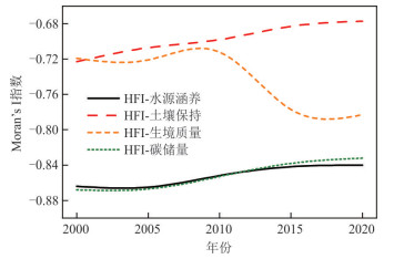
为了解秦岭北麓西安段人类活动对生态系统的影响,采用人类足迹指数表征人类活动强度,通过InVEST模型评价生态系统服务功能,分析近20 a秦岭北麓西安段人类活动与生态系统服务时空演化规律,凝练二者在海拔梯度上的空间关联特征. 结果表明:近20 a研究区高和较高等级的人类活动强度区面积分别扩大了5.99倍和1.85倍. 人类活动强度提高的区域主要集中在周至县平原区、山前控制带和4条主要峪道,城镇化、公路建设和旅游业发展是秦岭北麓人类活动强度增大的主要原因. 秦岭北麓生态系统的水源涵养、土壤保持和碳储量受到人类活动的影响程度逐渐减弱,稳定性有所提升;生境质量对人类活动变化表现的愈加敏感,低山区人类活动强度的增大削弱了生境质量的稳定性. 秦岭北麓人地关系存在明显的海拔分异特征. 从人类活动-生态系统服务关联特征角度开展秦岭北麓人地协调分区时,可根据海拔将秦岭北麓分为人地冲突强烈区(< 853 m);人地协调失衡区(853~1 105 m);人地协调敏感区(1 105~1 576 m)和人地关系平衡区(> 1 576 m).
Abstract:In order toelucidate the impact of human activities on ecosystem in Xi 'an section of the northern foot of Qinling Mountains, the spatio-temporal evolution of human activities and ecosystem services in the region in the past 20 years was analyzed in the present study.The human footprint index is adopted to quantify intensity of human activities. The InVEST model is used to evaluate the ecosystem services.Their spatial correlation characteristics are analyzed from the perspective of altitude gradient.The results indicate that the area of high and relatively high level human activity intensity increased by 5.99 times and 1.85 times, respectively. The areas where the intensity of human activities increased were mainly concentrated in the plain area of Zhouzhi County, the control zone in front of mountains and the four main valley roads. Urbanization, highway construction and tourism development are the main reasons for the increase of human activities in the northern foot of Qinling Mountains. In the past 20 years, the water conservation, soil conservation and carbon storage service functions of the ecosystem in the northern foot of the Qinling Mountains have been gradually weakened by human activities. Their stability has improved. However, habitat quality has become more sensitive to changes in human activities. The increasing intensity of human activities in the low mountainous areas weakened the stability of habitat quality. The coordination areas between human activities and ecological environment in the northern foot of Qinling Mountains can be divided into four categories: intense conflict area of human-land relationship (< 853 m), unbalance area of human-land coordination (853~1 105 m), sensitive area of human-land coordination (1 105~1 576 m), balance area of human-land relationship (> 1 576 m).
-
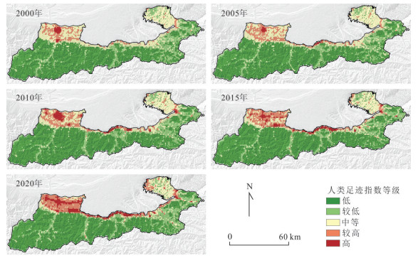
图 3 2000—2020年秦岭北麓人类足迹指数空间分布
Fig. 3. Spatial distribution of human footprint index in the northern foot of Qinling Mountains from 2000 to 2020
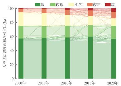
图 4 近20 a秦岭北麓人类足迹指数转移情况
Fig. 4. Human footprint index transfer in the northern foothills of Qinling Mountains in recent 20 years
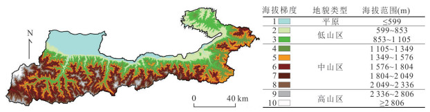
图 5 近20 a人类足迹指数及其变化随高程分布
Fig. 5. Human footprint index and its variation with elevation in recent 20 years
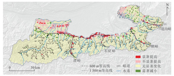
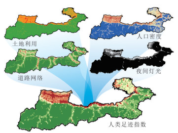
图 6 2000—2020年秦岭北麓人类活动变化
Fig. 6. Change of human activities in the northern foot of Qinling Mountains from 2000 to 2020
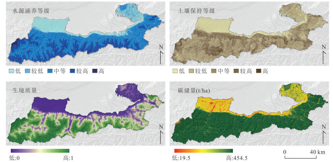
图 7 秦岭北麓2020年生态系统服务空间分布
Fig. 7. Spatial distribution of ecosystem services in the northern foot of Qinling Mountains in 2020
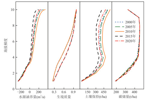
图 9 近20 a生态系统服务功能沿海拔梯度的变化规律
Fig. 9. Changes of ecosystem service function along elevation gradient in recent 20 years
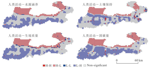
图 10 秦岭北麓2020年人类活动强度-生态系统服务功能空间关联特征
Fig. 10. Spatial correlation between human activity intensity and ecosystem service function in the northern foot of Qinling Mountains in 2020
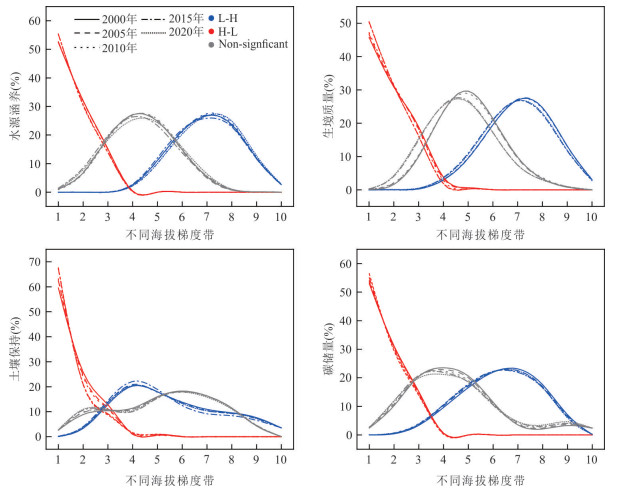
图 11 不同海拔梯度带上HFI-ESs空间聚集特征
Fig. 11. Spatial aggregation characteristics of HFI-ESs in different altitude gradient belts
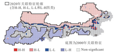
图 13 2000—2020年人类活动与生境质量关联特征空间变异规律
Fig. 13. Spatial variation of correlation characteristics between human activities and habitat quality from 2000 to 2020
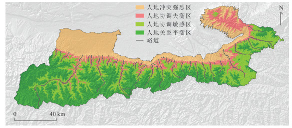
图 14 基于人类活动-生态系统服务相关性的秦岭北麓(西安段)人地协调分区
Fig. 14. Human-land coordination area in northern Qinling Mountains based on the correlation between human activities and ecosystem services
表 1 威胁因素系数
Table 1. Threat factors coefficient
威胁因素 最长威胁距离drmax(km) 权重ωr 距离函数衰减类型 耕地 4 0.7 指数衰减 建筑用地 8 1.0 指数衰减 公路 6 1.0 线性衰减 铁路 2 0.8 线性衰减  下载: 导出CSV
表 2 土地利用类型对生境威胁因子的敏感性(Sjr)
Table 2. Sensitivity of land use types to habitat threat factors (Sjr)
土地利用 生境适宜度 耕地 建设用地 公路 铁路 耕地 0.4 0.25 0.40 0.40 0.30 林地 1.0 0.70 0.80 0.80 0.75 灌木 1.0 0.70 0.80 0.80 0.75 草地 1.0 0.70 0.75 0.80 0.75 水体 0.8 0.65 0.70 0.65 0.60 建筑用地 0 0 0 0 0 荒地 0 0 0 0 0
下载: 导出CSV
表 3 各地类碳库数据表(单位:t/ha)
Table 3. Carbon pool data for each land use(Unit: t/ha)
土地利用 Cabove Cbelow Csoil Cdead 耕地 46.50 80.50 107.30 13.00 林地 58.30 115.20 268.00 13.00 灌木 39.45 82.83 163.13 7.61 草地 20.59 50.46 58.28 2.22 水体 0 70.00 0 0 建筑用地 3.50 5.45 10.57 0 荒地 9.20 0.10 12.50 0
下载: 导出CSV
-
Chen, S. S., Liu, K., Li, T., et al., 2016. Evaluation of Ecological Service Function of Soil Conservation in Shangluo City Based on InVEST Model. Acta Pedologica Sinica, 53(3): 800-807(in Chinese with English abstract). Cui, X. L., Bai, H. Y., Wang, T., 2013. Difference in NDVI with Altitudinal Gradient and Temperature in Qinling Area. Resources Science, 35(3): 618-626(in Chinese with English abstract). Darvill, R., Lindo, Z., 2016. The Inclusion of Stakeholders and Cultural Ecosystem Services in Land Management Trade-off Decisions Using an Ecosystem Services Approach. Landscape Ecology, 31: 533-545. https://doi.org/10.1007/s10980-015-0260-y Duan, Q. T., Luo, L. H., 2020. A Dataset of Human Footprint Over the Qinghai-Tibet Plateau During 1990-2015. China Scientific Data, 5(3): 303-312(in Chinese with English abstract). Ellis, E., Ramankutty, N., 2008. Putting People in the Map: Anthropogenic Biomes of the World. Frontiers in Ecology and the Environment, 6(8): 439-447. https://doi.org/10.1890/070062 FAO, IIASA, 2023. Harmonized World Soil Database version 2.0. Rome and Laxenburg. https://doi.org/10.4060/cc3823en Guo, S. Z., Bai, H. Y., Meng, Q., et al., 2018. Landscape Pattern Phange and Its Response to Anthropogenic Disturbance inthe Qinling Mountains During 1980 to 2015. Chinese Journal of Applied Ecology, 29(12): 4080-4088(in Chinese with English abstract). HJ 1173-2021, 2021. Technical Specification for Investigation and Assessment of National Ecological Status: Ecosystem Services Assessment. Ministry of Ecology and Environment of the People's Republic of China, Beijing (in Chinese). Huang, Z. A., Chen, Y. B., Zheng, Z. H., et al., 2023. Spatiotemporal Coupling Analysis Between Human Footprint and Ecosystem Service Value in the Highly Urbanized Pearl River Delta Urban Agglomeration, China. Ecological Indicators, 148: 110033. https://10.1016/j.ecolind.2023.110033 doi: 10.1016/j.ecolind.2023.110033 Ji, Y. H., Zhou, G. S., Wang, S. D., et al., 2021. Evolution Characteristics and Its Driving Forces Analysis of Vegetation Ecological Quality in Qinling Mountains Region from 2000 to 2019. Chinese Journal of Plant Ecology, 45(6): 617-625(in Chinese with English abstract). doi: 10.17521/cjpe.2020.0253 Li, S., Wu, J., Gong, J., et al., 2018. Human Footprint in Tibet: Assessing the Spatial Layout and Effectiveness of Nature Reserves, Science of The Total Environment, 621: 18-29. https://10.1016/j.scitotenv.2017.11.216 doi: 10.1016/j.scitotenv.2017.11.216 Li, X., Li, D. R., Xu, H. M., et al., 2021. Intercalibration between DMSP/OLS and VIIRS Night-Time Light Images to Evaluate City Light Dynamics of Syria's Major Human Settlement during Syrian Civil War. Remote Sensing of Night-Time Light. London, Routledge, 80–97. https://doi.org/10.4324/9781003169246-5 Liu, D. Q., Cao, E. J., Zhang, J. X., et al., 2020. Spatiotemporal Pattern of Water Conservation and Its Influencing Factors in Bailongjiang Watershed of Gansu. Journal of Natural Resources, 35(7): 1728-1743(in Chinese with English abstract). doi: 10.31497/zrzyxb.20200716 Liu, T., Ren, C., Zhang, S., et al., 2022. Coupling Coordination Analysis of Urban Development and Ecological Environment in Urban Area of Guilin Based on Multi-Source Data. International Journal of Environmental Research and Public Health, 19(19): 12583. https://10.3390/ijerph191912583. doi: 10.3390/ijerph191912583 Ma, L., Wang, C. M., Wang, L. Y., et al., 2023. Study of Spatiotemporal Variation and Driving Factors of Habitat Quality in the Northern Foothills of the Qinling Mountains: a Case Study of Xi'an, China. Frontiers in Ecology and Evolution, 11: 1284281. https://doi.org/10.3389/fevo. 2023. 1284281 doi: 10.3389/fevo.2023.1284281 Peng, S. Z., 2020. 1km Monthly Precipitation Dataset for China (1901-2023). National Tibetan Plateau/Third Pole Environment Data Center. https://doi.org/10.5281/zenodo.3114194 Peng, S. Z., 2022. 1 km Monthly Potential Evapotranspiration Dataset in China (1901-2023). National Tibetan Plateau/Third Pole Environment Data Center. https://doi.org/10.11866/db.loess.2021.001 Peng, J. B., Shen, Y. J., Jin, Z., et al., 2023. Key Thoughts on the Study of the Eco-Geological Environment System in Qinling Mountains. Acta Ecologica Sinica, 43(11): 4344-4358(in Chinese with English abstract). Reid, W. V., Mooney, H. A., Cropper, A., et al., 2005. Ecosystems and Human Well-being-Synthesis: A Report of the Millennium Ecosystem Assessment. Island Press, Washington, D. C. Ren, Z. G., Tian, Z. H., Wei, H. T., et al., 2022. Spatiotemporal Evolution and Driving Mechanisms of Vegetation in the Yellow River Basin, China during 2000—2020. Ecological Indicators, 138: 108832. https://doi.org/10.1016/j.ecolind.2022.108832 Sanderson, E. W., Jaiteh, M., Levy, M. A., et al., 2002. The Human Footprint and the Last of the Wild: the Human Footprint is a Global Map of Human Influence on the Land Surface, Which Suggests that Human Beings Are Stewards of Nature, Whether We Like It or Not. BioScience, 52(10): 891-904. https://doi.org/10.1641/0006-3568(2002)052[0891:thfatl]2.0.co;2 Sharp, R., Chaplin-Kramer, R., Wood, S., et al., 2018. InVEST User's Guide. Shen, Y. J., Chen, X., Peng, J. B., et al., 2024. Background Characteristics of Ecological Geological Environment System in the Qinling Mountains and Assumption of Its Theoretical System. Earth Science, 49(6): 2103-2119(in Chinese with English abstract). Si, F., Li, K., Huang, T. L., et al., 2024. Temporal and Spatial Variation in Atmospheric Wet Deposition of Nutrients and Organic Matter at the Southern and Northern Foothills of the Qinling Mountains. Water Science & Technology, 90(2): 631-648. https://doi.org/10.2166/wst.2024.237 Sun, Y. H., Zhang, S. R., Xu, Q. H., 2022. Pollen-Based Land Cover Changes Reveal Temporal and Spatial Differences of Human Activity in North-Central China During the Holocene. Catena, 219: 106620. https://10.1016/j.catena.2022.106620 doi: 10.1016/j.catena.2022.106620 Terrado, M., Sabater, S., Chaplin-Kramer, B., et al., 2016. Model Development for the Assessment of Terrestrial and Aquatic Habitat Quality in Conservation Planning. Science of The Total Environment, 540: 63-70. https://https://doi.org/10.1016/j.scitotenv.2015.03.064 Woolmer, G., Trombulak, S. C., Ray, J. C., et al., 2008. Rescaling the Human Footprint: A Tool for Conservation Planning at an Ecoregional Scale. Landscape and Urban Planning, 87(1): 42-53. https://https://doi.org/10.1016/j.landurbplan.2008.04.005 Wang, X. C., 2022. Evolution of Ecosystem Services of WeiheRiver Basin in Shaanxi Qinling Mountainbased on InVEST Model(Dissertation). Northwest University, Xi'an, 30(in Chinese with English abstract). Wu, W. Q., Zhao, Y., Tian, H. W., et al., 2023. Spatio-Temporal Variation Characteristics and Driving Mechanism of Habitat Quality of Qinling Mountains in Recent 40 Years. Journal of Earth Environment, 14(4): 488-504(in Chinese with English abstract). Wu, Y., Wu, Y. M., Gao, B. B., et al., 2023. Spatial Relationship between Human Activity Intensities and Ecosystem Services Value in Chengdu-Chongqing Urban Agglomeration. Research of Soil and Water Conservation, 30(1): 173-182(in Chinese with English abstract). Xu, Z. H., Wei, H. J., Fan, W. G., et al., 2019. Relationships Between Ecosystem Services and Human Well-Being Changes Based on Carbon Flow: A Case Study of The Manas River Basin, Xinjiang, China. Ecosystem Services, 37, 100934. https://10.1016/j.ecoser.2019.100934. doi: 10.1016/j.ecoser.2019.100934 Yang, J., Huang, X., 2021. The 30 m Annual Land Cover Dataset and Its Dynamics in China from 1990 to 2019. Earth System Science Data, 13(8): 3907-3925. https://10.5194/essd-13-3907-2021 doi: 10.5194/essd-13-3907-2021 Yang, Y., Zhu, X., 2024. Distribution and Change Characteristics of Ecosystem Services in Highly Urbanized Areas along Gradients of Human Activity Intensity: A Case Study of Shenzhen City, China. Sustainability, 16(6): 2543. https://10.3390/su16062543. doi: 10.3390/su16062543 Zhang, C. X., Xie, G. D., Yang, Q. K., et al., 2008. Influence of Human Activities on the Value of Ecosystem Services: CaseStudy of Zhifanggou Watershed. Resources Science, 30(12): 1910-1915(in Chinese with English abstract). Zhang, X. Y., Ning, X. G., Wang, H., et al., 2022. Impact of Human Footprint on Landscape Fragmentation in the Northeastern China Tiger and Leopard National Park. Acta Ecologica Sinica, 42(11): 4688-4702 (in Chinese with English abstract). Zhang, Y. Z., Yin, H. R., Zhu, L. Q., et al., 2021. Landscape Fragmentation in Qinling-Daba Mountains Nature Reserves and Its Influencing Factors. Land, 10(11): 1124. https://doi.org/10.3390/land10111124 Zhang, Z., 2022. Research on the Carbon Source/Sink Characteristics of the Ecosystem on the Southern Slope of the Qilianmountains and Its Effect Factors of Carbon Pool(Dissertation). Qinghai Normal University. Xining, 55-56(in Chinese with English abstract). Zheng, B. J., Liu, X. F., Zhou, Z. X., 2022. Effects of Human Activities on Ecosystem Quality in Qinling-Daba Mountains: A Case Study of Hanzhong city. Journal of Shaanxi Normal University(Natural Science Edition), 50(4): 45-58(in Chinese with English abstract). 陈姗姗, 刘康, 李婷, 等, 2016. 基于InVEST模型的商洛市水土保持生态服务功能研究. 土壤学报, 53(3): 800-807. 崔晓临, 白红英, 王涛, 2013. 秦岭地区植被NDVI海拔梯度差异及其气温响应. 资源科学, 35(3): 618-626. 段群滔, 罗立辉, 2020. 1990–2015年青藏高原人类足迹数据集. 中国科学数据(中英文网络版), 5(3): 303-312. 郭少壮, 白红英, 孟清, 等, 2018. 1980—2015年秦岭地区景观格局变化及其对人为干扰的响应. 应用生态学报, 29(12): 4080-4088. HJ 1173-2021, 2021. 全国生态状况调查评估技术规范——生态系统服务功能评估. 北京: 中华人民共和国生态环境部. 汲玉河, 周广胜, 王树东, 等, 2021.2000–2019年秦岭地区植被生态质量演变特征及驱动力分析. 植物生态学报, 45(6): 617-625. 柳冬青, 曹二佳, 张金茜, 等, 2020. 甘肃白龙江流域水源涵养服务时空格局及其影响因素. 自然资源学报, 35(7): 1728-1743. 彭建兵, 申艳军, 金钊, 等, 2023. 秦岭生态地质环境系统研究关键思考. 生态学报, 43(11): 4344-4358. 申艳军, 陈兴, 彭建兵, 等, 2024. 秦岭生态地质环境系统本底特征及研究体系初步构想. 地球科学, 49(6): 2103-2119. doi: 10.3799/dqkx.2023.210 王晓晨, 2022. 基于InVEST模型的陕西秦岭(渭河流域)生态系统服务评估(博士学位论文). 西安: 西北大学, 30. 武文琦, 赵燕, 田瀚文, 等, 2023. 近40 a秦岭生境质量时空变化特征及驱动机制. 地球环境学报, 14(4): 488-504. 武燕, 吴映梅, 高彬嫔, 等, 2023. 成渝城市群生态系统服务价值与人类活动强度空间关系. 水土保持研究, 30(1): 173-182. 张彩霞, 谢高地, 杨勤科, 等, 2008. 人类活动对生态系统服务价值的影响——以纸坊沟流域为例. 资源科学, 30(12): 1910-1915. 张晓宇, 宁晓刚, 王浩, 等, 2022. 人类足迹对东北虎豹国家公园景观破碎化的影响. 生态学报, 42(11): 4688-4702. 张卓, 2022. 祁连山南坡生态系统碳源/汇特征及碳库影响因素研究(博士学位论文). 西宁: 青海师范大学, 55-56. 郑碧军, 刘晓芳, 周忠学, 2022. 秦巴山区人类活动对生态系统质量的影响——以汉中市为例. 陕西师范大学学报(自然科学版), 50(4): 45-58. -

 点击查看大图
计量
- 文章访问数: 34
- HTML全文浏览量: 20
- PDF下载量: 5
- 被引次数: 0
