


Preliminary Study on the Characteristics of Landslides and Soil Liquefaction Triggered by the Dingri MS6.8 Earthquake on January 7, 2025, Southern Tibetan Plateau
-
摘要:
现今强震触发次生灾害空间展布的快速遥感制图,对强震致灾机理完整认识有重要意义,青藏高原具有高海拔、人口稀少、野外调查困难等特点,因此,利用震后高分辨率卫星影像开展地震触发滑坡及砂土液化的分布规律研究,具有特别重要的研究意义.为了系统获取2025年1月7日定日MS6.8地震触发的次生灾害的空间展布特征,利用国产卫星的应急成像影像数据,通过震前、震后影像对比的人工目视解译方法,结合野外实地调查,获得如下认识:(1)定日地震触发的同震滑坡2 869处,具有南北两个集中分布区,60%集中海拔为5 000~6 000 m的区域,且以坡面碎屑及局部崩塌为主,土方量较小,远离居民点;(2)定日地震触发的砂土液化点~40万处,集中分布在海拔为4 100~4 300 m的朋曲河的河漫滩及低阶地上,德么错盆地、郭加盆地、定结盆地均有密集分布,部分位于5 200 m的第四纪冰碛物中.此次定日地震触发的同震滑坡以位于高海拔区域(~5 000 m)的有限的坡面碎屑流为主,可能对应高海拔区域的基岩表层风化层的陡坡度部位的震中地形放大效应,而砂土液化空间分布覆盖定结‒申扎裂谷南段的3个盆地,表明裂谷系的次级断裂的破裂事件可以导致邻近多个盆地内的严重同震液化现象,与各自盆地断裂是否发生破裂无关.
Abstract:The rapid mapping of secondary effects triggered by strong earthquakes is crucial for understanding the disaster-causing mechanisms of mainshock events. The Tibetan Plateau, characterized by its higher altitude, sparse population, and challenging field conditions, presents significant difficulties for on-site investigations. Consequently, it is significant to analyze the distribution of earthquake-induced landslides and soil liquefaction utilizing post-earthquake emergency satellite imagery. We aim to systematically identify the spatial distribution characteristics of secondary hazards triggered by the MS6.8 Dingri earthquake on January 7, 2025. We utilized emergency imaging data from high-resolution Chinese satellite images. We employed manual visual interpretation through a comparative analysis of pre- and post-earthquake imagery supplemented by field investigations. The following results are obtained: (1) The mainshock triggered 2 869 coseismic landslides, with two major concentration zones in the north and south. Approximately 60% of these landslides occurred in high-altitude regions between 5 000-6 000 m, predominantly manifesting as slope debris flows and collapses with limited effect for far away the residents. (2) The mainshock also induced about 400, 000 soil liquefaction pits, primarily concentrated in the floodplains and low terraces of the Pengqu River at elevations of 4 100-4 300 m. These liquefaction sites are distributed across the Democuo Basin, Guojia Basin, and Dingjie Basin, with some occurrences in Quaternary tills at elevations reaching 5 200 m. The distribution pattern of coseismic landslides, primarily as slope debris flows in higher-altitude (about 5 000 m) areas, suggests a possible correlation with the topographic amplification effect. Meanwhile, the spatial extent of soil liquefaction, spanning three basins in the southern section of the Dingjie-Shenzha Rift system, indicates that single secondary-fault rupture event within a single basin can significantly impact other adjacent secondary-faulted basins, leading to severe secondary disasters, even the controlled faults without coseismal faulting.
-
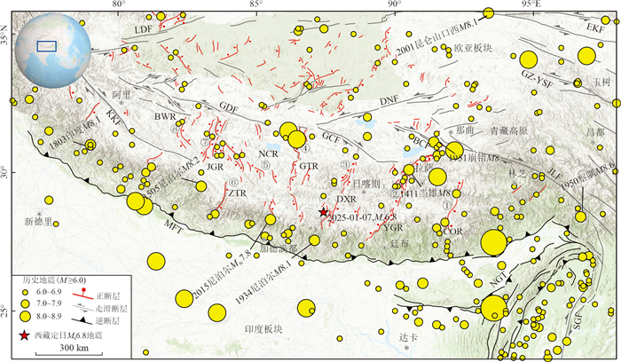
图 1 藏南裂谷系区域构造
藏南裂谷系名称(自东向西):①错那‒桑日裂谷系(COR);②亚东‒谷露裂谷系(YGR);③定结‒申扎裂谷系(DXR);④岗嘎‒当惹雍措裂谷系(GTR);⑤聂拉木‒措勤裂谷系(NCR);⑥仲巴‒塔若错裂谷系(ZTR);⑦江曲藏布‒改泽裂谷系(JGR);⑧普兰‒文布当桑裂谷系(BWR);断裂名称:MFT.主前锋逆冲断裂带;NGT.娜迦逆冲带;SGF.实皆断裂带;JLF.嘉黎断裂带;KKF.喀拉‒昆仑断裂带;GDF.改则‒洞错断裂带;LBF.龙木错‒独立石湖断裂;DNF.多玛‒尼玛断裂带;GCF.格仁错断裂带;BCF.崩错断裂带;EKF.东昆仑断裂带;GZ-YSF.甘孜‒玉树断裂带
Fig. 1. Tectonic map of the southern Tibetan rift systems
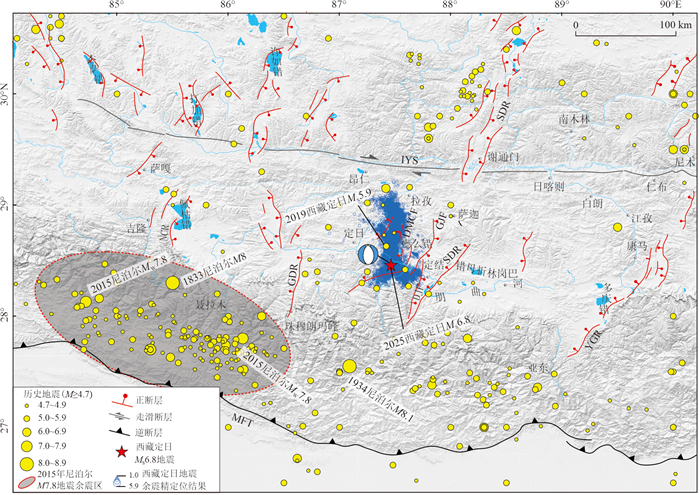
图 2 2025年定日地震的主震与余震及周边活动断裂分布
YGR.亚东‒谷露裂谷系;DSR.定结‒申扎裂谷系;GTR.岗嘎‒当惹雍措裂谷系;NCR.聂拉木‒措勤裂谷系;MFT.主前锋逆冲断裂带;IYS.雅鲁藏布江缝合带;DJF.定结断裂;GJF.郭加断裂;DMCF.德么错断裂
Fig. 2. The main shock and aftershocks of the 2025 Dingri earthquake and the distribution map of surrounding active faults
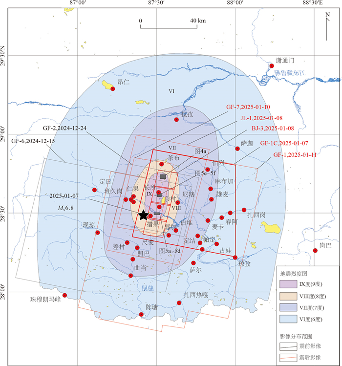
图 3 定日地震震中区及周边的震前(黑色多边形)、震后(红色多边形)卫星影像覆盖分布
震前影像获取时间为震前1个月内,可以准确代表震前震中区的地表地貌特征;震后影像获取时间为地震当天至5 d内,覆盖的范围包含了Ⅶ度区的绝大部分区域,Ⅶ度区北侧拉孜县附近的区域未覆盖
Fig. 3. Satellite image coverage distribution map of the epicenter of the Dingri earthquake and its surrounding areas before the earthquake (black polygons) and after the mainshock (red polygons)
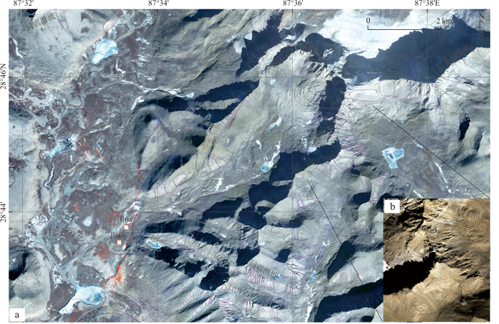
图 4 地震当天3 h后获取的GF-1C卫星影像(a)显示拉昂村东北方向发育在冰碛物上的同震地表破裂及触发的5 200 m以上的同震滑坡(b)(位置见图 3)
同震地表破裂沿德么错断裂已有迹线展布(a),同震地表变形带局部宽度可达300 m;第四纪冰碛物上发育有砂土液化和震动变形带;同震滑坡主要沿着朋曲河与雅鲁藏布江的分水岭一带发育,解译的同震滑坡(粉红色多边形)以沿坡面的崩塌或坡面碎屑流为主(b),坡脚堆积规模有限表明滑坡的实际体积远小于预期
Fig. 4. The fresh GF-1C image (a) acquired 3 h after the mainshock showing the coseismic surface rupture developed on the moraine and the coseismic landslides (b) with an altitude of about 5 200 m at northeast of La'ang Village (see the location in Fig. 3)
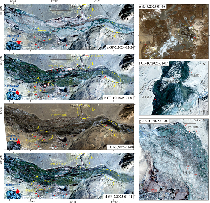
图 5 定日地震震中措果乡附近的朋曲河河谷震前(a)、震后(b‒d)卫星影像上同震密集砂土液化导致的河漫滩及低阶地上的纹理显著差异,茶布南(e)、朋曲河与叶如茶布河交汇处(f)及定结县东北侧的叶如藏布河谷(g)的密集砂土液化(位置见图 11)
Fig. 5. Satellite images of the Pengqu River valley near the epicenter, Cuoguo Township, before (a) and after (b‒d) the earthquake show significant differences in texture on the river floodplain and low terraces caused by densely coseismic soil liquefaction. Dense soil liquefaction at site of southern of Chabu Village (e), the site of confluence of the Pengqu River and the Yeruchabu River (f) and valley of Yeruzangbo River Valley, northeast of Dingjie County (g) (see the location in Fig. 11)
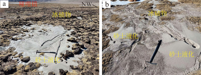
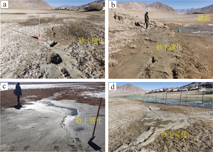
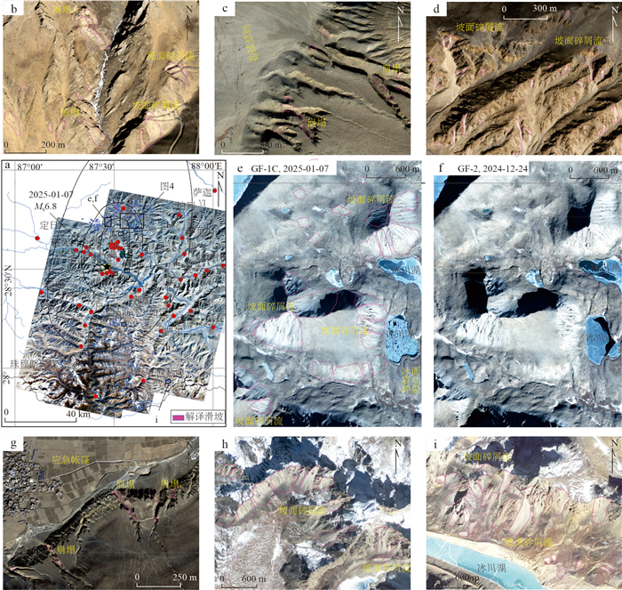
图 8 定日地震触发的同震滑坡解译分布
广义的同震滑坡的总体数量较少,多表现为沿着坡面的崩塌或者坡面上的风化岩石碎屑发生部分崩落,一般规模较小(b~d,g)通过局部区域震前(e)震后(f)的影像对比来看,同震滑坡的土方量较小,均在原来的高海拔坡面碎屑发生的部位强烈震动情况下部分碎屑物发生崩落所致,发生滑坡的为主多集中在第四纪冰川发生的位置(e,h,i)
Fig. 8. Extracted distribution map of coseismic landslides triggered by the Dingri earthquake
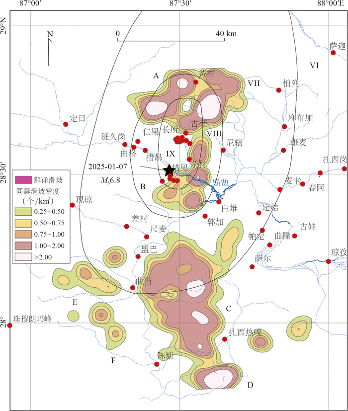
图 9 定日地震触发滑坡点核密度分布
Fig. 9. Kernel density distribution map of coseismic landslide triggered by the Dingri earthquake
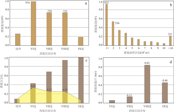
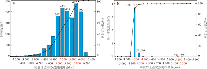
图 10 定日地震触发滑坡面积区间(b)及与烈度分布(a,c,d)统计
Fig. 10. Statistical diagram of landslide area range (b) and seismically intensity distribution (a, c, d) triggered by the main shock
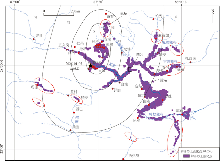
图 11 定日地震触发的砂土液化解译点分布
定日地震解译液化点分布有3个主要特征:(1)液化主要沿着朋曲河河谷及低阶地上密集分布,自郭加以上至措昂包含震中附近的朋曲河段,在定结县城所在的叶如藏布的宽缓河面上也分布有大量的液化点,距离震中已超过40 km,主体位于Ⅵ度区内;(2)宏观震中长所至德莫么湖沿线发育有数量较多的液化点;(3)部分液化点位于古荣至茶布的同震地表破裂迹线沿线的第四纪冰川沉积物上,海拔超过5 200 m
Fig. 11. Distribution map of coseismic soil liquefaction triggered by the main shock
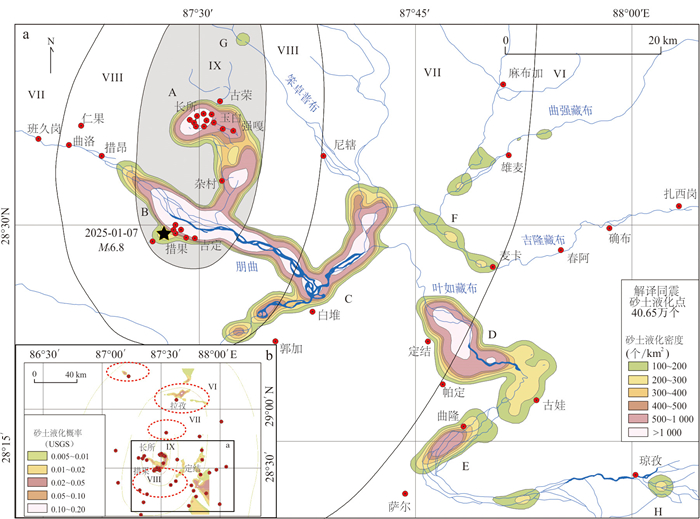
图 12 解译砂土液化核密度分布(a)及USGS估计的液化概率分布(b)
Fig. 12. Interpretation of the soil liquefaction kernel density distribution map (a) and the liquefaction probability distribution map estimated by USGS (b)
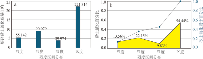
图 13 定日地震触发砂土液化与不同烈度之间的统计关系分布
Fig. 13. Distribution of the statistical relationship between soil liquefaction triggered by the Dingri earthquake and different seismically intensities
-
Armijo, R., Tapponnier, P., Mercier, J. L., et al., 1986. Quaternary Extension in Southern Tibet: Field Observations and Tectonic Implications. Journal of Geophysical Research: Solid Earth, 91(B14): 13803-13872. https://doi.org/10.1029/jb091ib14p13803 Chen, W. K., Rao, G., Kang, D. J., et al., 2023. Early Report of the Source Characteristics, Ground Motions, and Casualty Estimates of the 2023 Mw 7.8 and 7.5 Turkey Earthquakes. Journal of Earth Science, 34(2): 297-303. https://doi.org/10.1007/s12583-023-1316-6 Deng, Q. D., Cheng, S. P., Ma, J., et al., 2014. Seismic Activities and Earthquake Potential in the Tibetan Plateau. Chinese Journal of Geophysics, 57(7): 2025-2042 (in Chinese with English abstract). Elliott, J. R., Walters, R. J., England, P. C., et al., 2010. Extension on the Tibetan Plateau: Recent Normal Faulting Measured by InSAR and Body Wave Seismology. Geophysical Journal International, 183(2): 503-535. https://doi.org/10.1111/j.1365-246x.2010.04754.x He, X. L., Xu, C., Qi, W. W., et al., 2021. Landslides Triggered by the 2020 Qiaojia Mw5.1 Earthquake, Yunnan, China: Distribution, Influence Factors and Tectonic Significance. Journal of Earth Science, 32(5): 1056-1068. https://doi.org/10.1007/s12583-021-1492-1 Hu, G. M., Xu, Y. R., Liu, H., et al., 2025. Discussion on Seismic-Generating Potential and Seismic Risk of Normal Fault Zone in South Tibet Rift System. Earth Science, 50(5): 1794-1812(in Chinese). Li, Z. C., Sun, J. Z., Ji, Z. W., et al., 2025. Rapid Simulation of Acceleration Time History at the Qomolangma Seismic Station during the Ms6.8 Dingri Earthquake in Tibet on January 7, 2025. Earth Science, 50(2): 798-804 (in Chinese with English abstract). Liang, P., Xu, Y. R., Zhou, X. C., et al., 2025. Coseismic Surface Ruptures of MW7.8 and MW7.5 Earthquakes Occurred on February 6, 2023, and Seismic Hazard Assessment of the East Anatolian Fault Zone, Southeastern Türkiye. Science China Earth Sciences, 68(2): 611-625. https://doi.org/10.1007/s11430-024-1457-7 Liu, J., Ji, C., Zhang, J. Y., et al., 2015. Seismogenic Tectonic Background and Characteristics of the Mw7.8 Earthquake in Nepal on April 25, 2015. Chinese Science Bulletin, 60(27): 2640-2655 (in Chinese with English abstract). doi: 10.1360/N972015-00559 Liu, J., Xu, J., Ou, Q., et al., 2023. Discussion on the Overestimated Magnitude of the 1920 Haiyuan Earthquake. Acta Seismologica Sinica, 45(4): 579-596 (in Chinese with English abstract). Liu-Zeng, J., Zhang, Z., Rollins, C., et al., 2020. Postseismic Deformation Following the 2015 MW7.8 Gorkha (Nepal) Earthquake: New GPS Data, Kinematic and Dynamic Models, and the Roles of Afterslip and Viscoelastic Relaxation. Journal of Geophysical Research: Solid Earth, 125(9). https://doi.org/10.1029/2020jb019852 Lu, L. Y., Xu, Y. R., Tang, J. C., et al., 2024. Using High-Spatial-Resolution Images to Extract the Distribution of Coseismic Landslides and Soil Liquefaction Triggered by the 2024 Hualien MW7.4 Earthquake in Eastern Taiwan. Earthquake Research Advances. https://doi.org/10.1016/j.eqrea.2024.100356 Molnar, P., Tapponnier, P., 1975. Cenozoic Tectonics of Asia: Effects of a Continental Collision: Features of Recent Continental Tectonics in Asia Can Be Interpreted as Results of the India-Eurasia Collision. Science, 189(4201): 419-426. https://doi.org/10.1126/science.189.4201.419 Sheng, S. Z., Wan, Y. G., Jiang, C. S., et al., 2015. Preliminary Study on the Static Stress Triggering Effects on China Mainland with the 2015 Nepal MS8.1 Earthquake. Chinese Journal of Geophysics, 58(5): 1834-1842 (in Chinese with English abstract). Shi, F., Liang, M. J., Luo, Q. X., et al., 2025. Seismogenic Structure and Coseismic Surface Rupture Characteristics of the M6.8 Dingri Earthquake in Tibet on January 7, 2025. Seismological Geology, 47(1): 1-15 (in Chinese). Wan, Y. G., Sheng, S. Z., Li, X., et al., 2015. Stress Influence of the 2015 Nepal Earthquake Sequence on Chinese Mainland. Chinese Journal of Geophysics, 58(11): 4277-4286 (in Chinese with English abstract). Wu, J. J., Chen, W. K., Jia, Y. J., et al., 2025. Rapid Seismic Intensity and Disaster Assessment Based on Dense Seismic Array: An Case of the 2025 Rikaze MS6.8 Earthquake in Xizang. Earth Science, 50(5): 1770-1781 (in Chinese with English abstract). https://doi.org/10.3799/dqkx.2025.035 Wu, Z. H., Zhao, G. M., Liu, J., 2016. Tectonic Genesis of the 2015 MS8.1 Earthquake in Nepal and Its Impact on Future Strong Earthquake Trends in the Tibetan Plateau and Adjacent Areas. Acta Geologica Sinica, 90(6): 1062-1082 (in Chinese with English abstract). Xu, X. W., Wang, S. G., Cheng, J., et al., 2025. Shaking the Tibetan Plateau: Insights from the MW7.1 Dingri Earthquake and Its Implications for Active Fault Mapping and Disaster Mitigation. NPJ Natural Hazards, 2: 16. https://doi.org/10.1038/s44304-025-00074-7 Xu, Y. R., He, H. L., Deng, Q. D., et al., 2018. The CE 1303 Hongdong Earthquake and the Huoshan Piedmont Fault, Shanxi Graben: Implications for Magnitude Limits of Normal Fault Earthquakes. Journal of Geophysical Research: Solid Earth, 123(4): 3098-3121. https://doi.org/10.1002/2017jb014928 Xu, Y. R., Liu‐Zeng, J., Allen, M. B., et al., 2022. Understanding Historical Earthquakes by Mapping Coseismic Landslides in the Loess Plateau, Northwest China. Earth Surface Processes and Landforms, 47(9): 2266-2282. https://doi.org/10.1002/esp.5375 Yang, T., Wang, S. G., Fang, L. H., et al., 2025. Analysis of Earthquake Sequence and Seismogenic Structure of the 2025 MS6.8 Dingri Earthquake in Tibetan Plateau. Earth Science, 50(5): 1721-1732 (in Chinese with English abstract). https://doi.org/10.3799/dqkx.2025.033 Zhang, P. Z., Wang, W. T., Gan, W. J., et al., 2022. Present Tectonic Deformation and Geodynamic Processes of the Tibetan Plateau. Acta Geologica Sinica, 96(10): 3297-3313 (in Chinese with English abstract). Zhao, B., Su, L. J., Xu, Q., et al., 2023. A Review of Recent Earthquake-Induced Landslides on the Tibetan Plateau. Earth-Science Reviews, 244. https://doi.org/10.1016/j.earscirev.2023.104534 Zhou, J., Li, L., 2025. An Open Access 90 m Resolution VS30 Data and Map for Areas Affected by the January 2025 M6.8 Dingri Xizang, China Earthquake. Earthquake Science, 38. https://doi.org/10.29382/eqs-D-25-00004 Zou, J. J., Shao, Z. G., He, H. L., et al., 2025. Surface Rupture Interpretation and Building Damage Statistics of the MS Earthquake in Dingri, Xizang Province, January 7, 2025. Seismological Geology, 47(1): 16-35 (in Chinese). 邓起东, 程绍平, 马冀, 等, 2014. 青藏高原地震活动特征及当前地震活动形势. 地球物理学报, 57(7): 2025-2042. 胡贵明, 徐岳仁, 刘晗, 等, 2025. 藏南裂谷系正断层带孕震潜力和地震危险性讨论. 地球科学, 50(5): 1794-1812. 李宗超, 孙吉泽, 纪志伟, 等, 2025. 2025年1月7日西藏定日MS6.8地震珠峰地震台加速度时程快速模拟. 地球科学, 50(2): 798-804. doi: 10.3799/dqkx.2025.009 刘静, 纪晨, 张金玉, 等, 2015. 2015年4月25日尼泊尔MW7.8级地震的孕震构造背景和特征. 科学通报, 60(27): 2640-2655. 刘静, 徐晶, 偶奇, 等, 2023. 关于1920年海原大地震震级高估的讨论. 地震学报, 45(4): 579-596. 盛书中, 万永革, 蒋长胜, 等, 2015. 2015年尼泊尔MS8.1强震对中国大陆静态应力触发影响的初探. 地球物理学报, 58(5): 1834-1842. 石峰, 梁明剑, 罗全星, 等, 2025. 2025年1月7日西藏定日6.8级地震发震构造与同震地表破裂特征. 地震地质, 47(1): 1-15. 万永革, 盛书中, 李祥, 等, 2015. 2015年尼泊尔强震序列对中国大陆的应力影响. 地球物理学报, 58(11): 4277-4286. 吴佳杰, 陈文凯, 贾艺娇, 等, 2025. 基于密集台阵的地震烈度及灾情快速评估——以2025年西藏日喀则MS6.8地震为例. 地球科学, 50(5): 1770-1781. 吴中海, 赵根模, 刘杰, 2016. 2015年尼泊尔MS8.1地震构造成因及对青藏高原及邻区未来强震趋势的影响. 地质学报, 90(6): 1062-1082. 杨婷, 王世广, 房立华, 等, 2025. 2025年1月7日西藏定日MS6.8地震余震序列特征与发震构造. 地球科学, 50(5): 1721-1732. 张培震, 王伟涛, 甘卫军, 等, 2022. 青藏高原的现今构造变形与地球动力过程. 地质学报, 96(10): 3297-3313. 邹俊杰, 邵志刚, 何宏林, 等, 2025. 2025年1月7日西藏定日MS地震地表破裂解译与建筑物震害损毁统计. 地震地质, 47(1): 16-35. -

 下载:
下载:
 点击查看大图
计量
- 文章访问数: 222
- HTML全文浏览量: 13
- PDF下载量: 35
- 被引次数: 0
